
Bingley Neighbourhood Development Plan
4. Social, Economic and Environmental Characteristics
4.1 Introduction
4.1.1 This section of the Neighbourhood Plan establishes the most recent social, economic and environmental information which sets the context for the challenges and opportunities facing the parish. Bradford Council has published information for the Bingley Sub-Area, but the boundaries of the area are smaller than the Parish which forms our Neighbourhood Area. This makes the data less useful for the Neighbourhood Plan.
4.2 Physical characteristics
4.2.1 The Parish is located to the northwest of urban area of Bradford, lying within Airedale Valley on the A650 Aire Valley Trunk Road, completed in 2004, which connects Bradford with the towns of Shipley, Bingley and Keighley. Bingley is served by two train stations (Bingley, and Crossflatts which was opened in 1982) that provide access to Bradford, Leeds, Carlisle and other major towns and cities in Yorkshire. It has a reasonable network of footpaths, cycleways, and public transport. Leeds Bradford Airport is only 10 miles away.
4.2.2 The Parish comprises the main town of Bingley together with the villages of Cottingley, Crossflatts, Eldwick, Gilstead and Micklethwaite. Beyond these main settlements, there are several hamlets, plus many isolated dwellings. The town is nestled in the Airedale Valley which provides it with a noteworthy setting amongst the surrounding Pennine moors. Some parts of the town, particularly Eldwick and Micklethwaite, lie uphill from the town centre, lending the town topographical and settlement distinctiveness between its different areas, but also challenges when it comes to the promotion of walking and cycling.
4.2.3 Bingley has a vibrant and historic town centre that provides the principal focus for shopping, social and leisure activity in the parish. A large part of its town centre is a Conservation Area and it has several other notable historical features including the Five Rise Locks on the Leeds Liverpool Canal. With the exception of Micklethwaite (which relies on Crossflatts), the other villages within Bingley town possess essential key local public and commercial services which access on foot by people living there.
4.3 Social Characteristics
4.3.1 Bingley is a popular, distinct and civil parish in the metropolitan district of Bradford, West Yorkshire. In 2021, the Census counted the population of the Parish as 23,170, which was 432 lower than the 23,602 recorded at the time of the 2011 Census. The working age and younger populations are lower than the West Yorkshire and England averages.
4.3.2 The Housing Needs Assessment (HNA), prepared as a supporting document to the Neighbourhood Plan, indicates (paragraph 16 of the HNA) that the population of Bingley is forecast to grow by 1,014 residents by 2030, with the majority of the increased population likely to be aged over 75 years.
4.3.3 In terms of ethnicity within the Bingley Sub-Area (statistics are drawn from an OCSI Local Insight Report produced by Bradford Council, for the sub-area), the 2011 Census records 91.7% of the population as White British, which is above the West Yorkshire average of 78.4%. 'Other ethnic groups' account for 1% of the population (slightly above the West Yorkshire average) while all other census classified ethnic groups (Asian, Black, Mixed, Multiple Ethnicities) are present below the average.
4.3.4 In 2011, the Census recorded 27.1% of households with dependent children. 2.2% of households in Bingley contained households with dependent children and no adult in employment. 23.6% of all households in Bingley contained one resident person with a long-term health problem or disability. 3.6% of households in this subset in Bingley also contained dependent children. The 2011 Census also recorded 553 lone parent households with dependent children (5.5%) of which 89.5% with female lone parents.
4.3.5 The OCSI report produced for the Bingley Sub-Area reports (for May 2020) 12.2% (slightly higher than the West Yorkshire average) of people living in the area as able to claim Attendance Allowance (payable to people over the age of 65 who are so severely disabled, physically or mentally, that they need a great deal of help with personal care or supervision.
4.4 Economic characteristics
4.4.1 Employment in the town has changed in recent years with the loss of major employers such as Bradford & Bingley's head office and a growth in small businesses. Predating these changes, the 2011 Census recorded 9.5% of economically active residents as self-employed, which was above the Bradford District and England averages. According to the 2021 Census, 17.3% of residents aged 16 years and over had no qualifications, 39.6% had Level 1, 2 or 3 qualifications, 5.9% were in apprenticeships, 37.6% with Level 4 qualifications and above, and 2.5% with other qualifications.
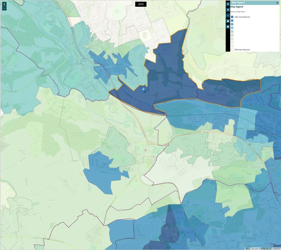
4.4.2 The Government's Indices of Multiple Deprivation for 2019, records the level of deprivation in England based on multiple indicators and ranks Local Super Output Areas (LSOAs) on a basket of indicators including employment, crime, environment, housing, health and other criteria. The lowest 20% of wards on the ranking are seen to exhibit the greatest level of deprivation. Within Bingley, the area to the east of Bingley Town Centre (LSOA Bradford 015D) is ranked in the 30% most deprived LSOAs in England. LSOA Bradford 018B straddles Bingley and Shipley Parishes and is ranked in the 10% most deprived LSOAs in England the number of people living in the most deprived 20% of area of England. Figure 2 shows the location of the LSOAs referred to with the darkest colours representing the most deprived LSOAs.
Figure 2: Levels of Deprivation within Bingley, 2019 Indices
Source: UK Government Indices of Multiple Deprivation Explorer Map.
4.4.3 Figure 3 shows the percentage composition of employment by Standard Industrial Classification as recorded at the Census in 2021
Figure 3: Key Employment Sectors in Bingley - number of people aged 16+ years, 2021
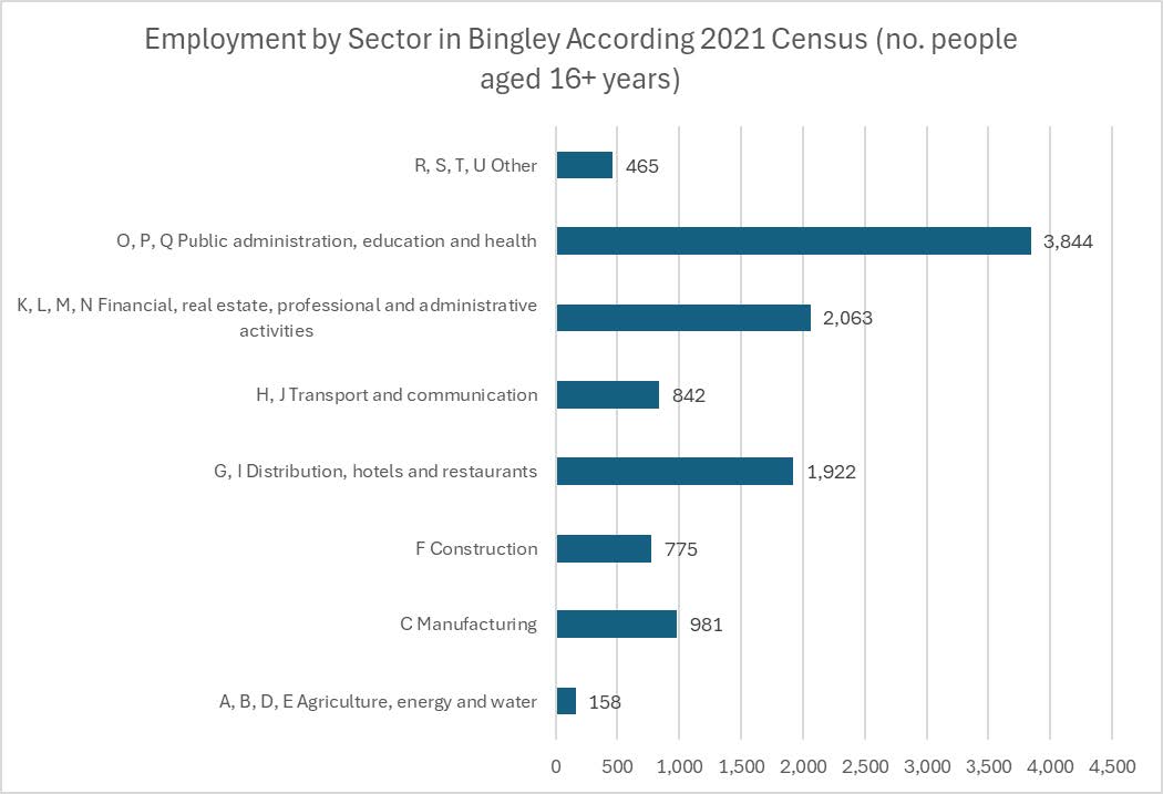
Source: 2021 Census
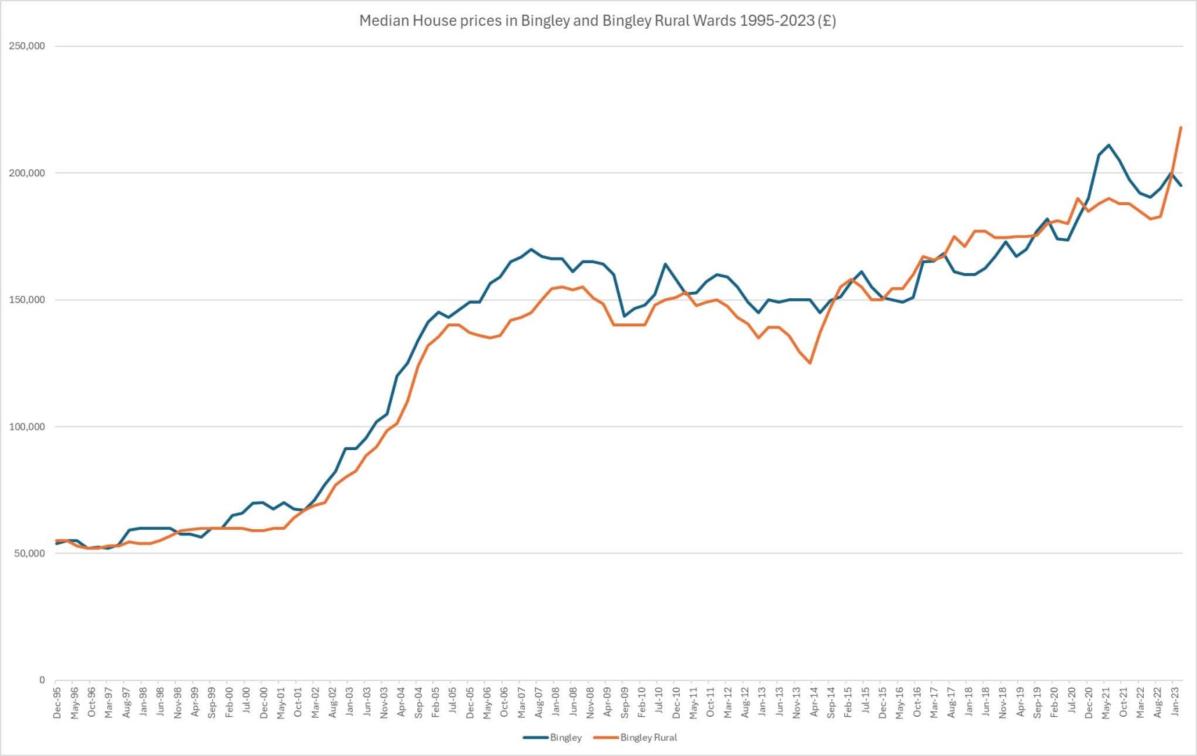
4.4.4 The attractiveness and location of the town mean that average house prices are higher than in neighbouring areas. Figure 4, below, charts house price trends by ward for the local area according to Office for National Statistics data, showing that the median average house price for the year ending March 2023, was £195,000 within Bingley Ward and £218,000 within Bingley Rural Ward.
4.4.5 The 2021 Census recorded the proportion of owner-occupied housing (including shared ownership) in the Bingley Parish at the 71.7%. 10.1% of households lived in social rented accommodation and the remainder were living in private rented accommodation or rent free.
4.4.6 The Census 2021 records around 10,500 households in Bingley Parish. 69.5% of households contained one or two persons. 96.4% of households were single person or single-family households. Larger houses predominate in the area with 62% of houses having three or more bedrooms, 27.3% have two bedrooms and 10.7% have one bedroom. In view of the high proportion of small households, 76.9% of households have at least one spare bedroom. Only 1.5% of households were recorded as lacking one or two bedrooms for their needs.
Figure 4: Median House Prices (£) in Bingley and Bingley Rural Wards, 1995-2023
4.5 Environmental characteristics
4.5.1 Within the wider parish, the South Pennine Moors are internationally recognised for nature conservation/biodiversity value. In addition to be designated as a Site of Special Scientific Interest (SSSI), they are also designated as Special Areas of Conservation (SAC) and Special Protection Areas (SPA).
4.5.2 Much of Bingley town is green and open in nature. This green landscape is important to the character and setting of the town as well as the wildlife and wildflowers it supports. These extensive green spaces support some important habitats and a wide variety of wildlife and wildflowers, some of which are rare or declining. There are several environmental assets that have been identified as of national significance. These include two Sites of Special Scientific Interest (SSSI), namely the South Pennine Moors, and Bingley South Bog. The Leeds-Liverpool Canal is a Local Wildlife Site designated by BMDC. Abutting the eastern boundary of the Parish is Trench Meadows SSSI.
4.5.3 Bingley has a rich history. One of the most obvious manifestations of this is the number of fine buildings that can be found within it. There are over a hundred 'Listed' Buildings that have been designated as of national architectural or historic importance. Many of these Listed Buildings lie in the four designated Conservation Areas (Bingley, Micklethwaite, Eldwick Beck and the Leeds-Liverpool Canal) that can be found fully or partly in the Parish.