
Oxenhope Neighbourhood Development Plan (Regulation 16) July 2021
6.0 APPENDIX
6.1 Non-designated heritage assets assessment
The criteria used to assess potential non-designated heritage assets is informed by the criteria provided by Historic England https://historicengland.org.uk/images-books/publications/local-heritage-listing-advice-note-7/
|
Criterion |
Description |
|||
|
Age |
The age of an asset may be important criterion, and the age range can be adjusted to take into account distinctive local characteristics of building traditions. |
|||
|
Rarity |
Appropriate for all assets, as judged against local characteristics |
|||
|
Aesthetic Interest |
The intrinsic value of an asset relating to local styles materials or any other distinctive local characteristics |
|||
|
Group Value |
Groupings of assets with clear visual design or historic relationship |
|||
|
Archeological Interest |
The local heritage asset may provide evidence about past human activity in the locality, which may be archeological - that is in the form of buried remains - but may also be revealed in the structure of buildings or in a manmade landscape. Heritage assets with archeological interests are the primary source of evidence about the substance and evolution of places, and of the people and cultures that made them. |
|||
|
Archival Interest |
The significance of a local heritage asset of any kind may be enhanced by a significant contemporary or historic written record. |
|||
|
Historical Association |
The significance of a local heritage asset of any kind may be enhanced by a significant historical association of local or national note, including links to important local figures. |
|||
|
Designated Landscape Interest |
The interest attached to locally important designated landscapes, parks and garden which may relate to their design or social history. This may complement a local green space designation, which provides special protection against development for green areas of particular importance to local communities for their current use. |
|||
|
Landmark Status |
An asset with strong communal or historical associations, or because it has especially striking aesthetic value, may be singled out as a landmark within the local scene. |
|||
|
Social and Communal Value |
Relating to places perceived as a source as local identity, distinctiveness, social interaction and coherence sometimes residing in intangible aspects of heritage, contributing to the 'collective memory' of place. |
|||
|
Feature name ( Map ref no.) |
Location |
Description |
Why is the feature of interest and significance? What evidence exists to support the proposed selection? |
|
|
Horkinstone gothic tombs (1) |
Horkinstone burial ground, Leeming Conservation Area. |
Pair of gothic style tombs |
Built in 1882 A pair of spired gothic style tombs with cross finials which stand at the western end of the cemetery dominate views of it. Both feature decorative carving, polished granite in the form of colonnettes and plaques and are encircled by highly ornate wrought iron railings. Both are key unlisted buildings. The two large monuments at the west end of the ground were not erected until 1882. The first burial in the large monument farthest away from the road (Grave 23/24) was that of William Crabtree of Leeming who was buried in 1885. The Crabtrees were stonemasons and building contractors who built reservoirs, schools and houses, which probably accounts for these two flamboyant grave memorials. The plot of the other large monument (Grave 27) alongside the main road, was owned by John Crabtree of Sykes in 1853, but not built until 1882 when his wife Mary died, he died 1894. Also buried in this vault are four Kershaws who were related to the Crabtrees. The Kershaws built the nearby worsted spinning Sykes Mill in 1847. Ebenezer Kershaw buried in 1933 was a councillor on the Oxenhope Urban District Council, the Overseer of the Parish of Oxenhope, and served as chairman of the Oxenhope Food Control Committee during the First World War. He lived at Woodville. His brother George Kershaw, of Mayfield, Station Road died in 1953 and was the last burial in that grave. BASIS OF DESIGNATION: Rarity, Aesthetic Value, Historical association, Social and Communal Value |
|
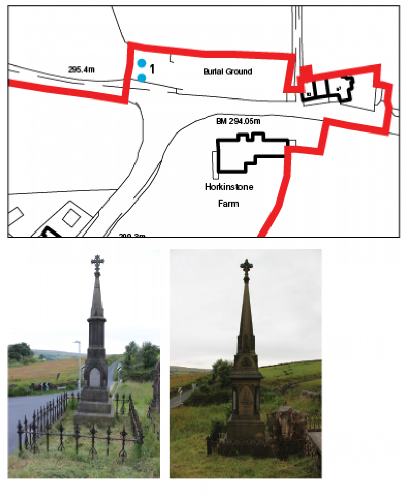
Map showing location of Horkinstone gothic tombs (1)
|
Feature name ( Map ref no.) |
Location |
Description |
Why is the feature of interest and significance? What evidence exists to support the proposed selection? |
|
Horkinstone barn & Horkinstone farm (2) |
Denholme Road, opposite Horkinstone burial ground |
A late 18th century grain store. |
Built in the late 18th century. Key unlisted building. Converted into a residential dwelling in 2008 but sympathetically retains much of its agricultural character. The segmented archway still dominates the roadside facade and renovation has been done sensitively with appropriate materials. BASIS OF DESIGNATION: Age, Social and Communal Value |
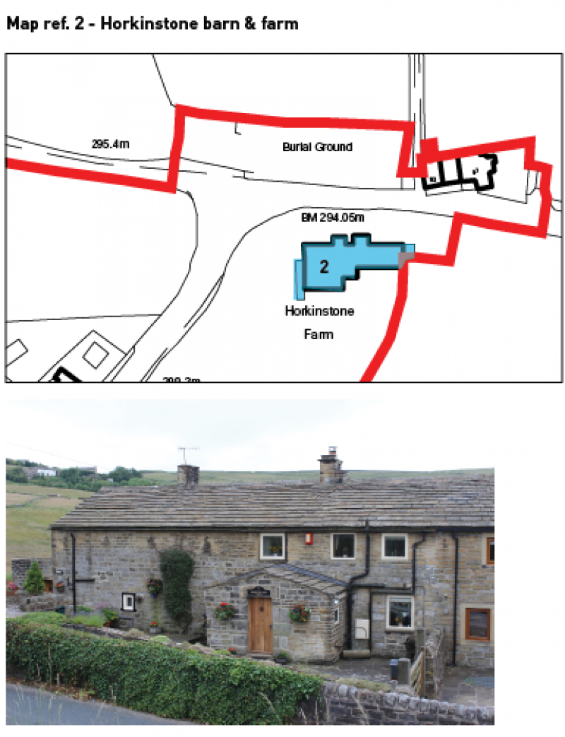
Map showing location of Horkinstone barn and farm
|
Feature name ( Map ref no.) |
Location |
Description |
Why is the feature of interest and significance? What evidence exists to support the proposed selection? |
|
Fernhill villa (3) |
Opposite Bull Hill |
Gothic Style picturesque villa |
The house was built in 1873 for the Pawson family, owners of Wadsworth Mill and the Olde Mill in Oxenhope. The Pawson family are important to Oxenhope, with several businesses throughout the village that employed local people. Many of these buildings still exist today including Pawsons Mill (George Emmott Ltd). The A-shape white timber bargeboards on each of the different sized gables/dormers which break up the steeply pitched overhanging slate roof are the most prominent features. The three bay front elevation is asymmetrical and the architraved pointed arch doorway with fanlight is off-centre. To the left is an ashlar canted bay window (a similar one can be found on the northern gable) and a pair of mullioned windows to the right. BASIS OF DESIGNATION: Historical Association, Social and Communal Value |
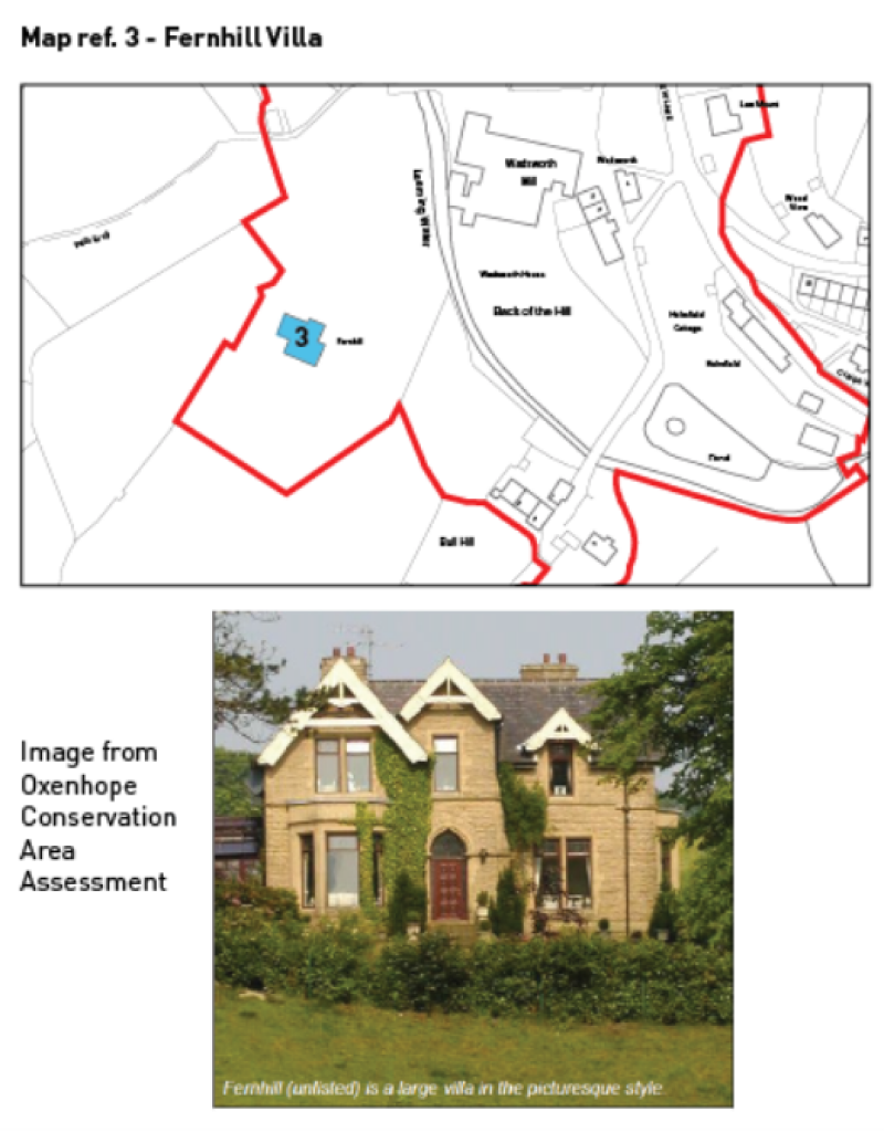
Map showing location of Fernhill Villa
|
Feature name ( Map ref no.) |
Location |
Description |
Why is the feature of interest and significance? What evidence exists to support the proposed selection? |
|
Bull Hill (4) |
Bull Hill |
Cottages, barn & workshop |
This group of buildings dates from the late 18th and early 19th century, being of two builds. All are key unlisted buildings. There was originally a mill (Bull Hill Mill) on this site that was established around 1810. It was occupied by local business owners Emmott/Pawsons spindle and flyer makers. The mill was still in use by 1870 when it burnt down. No trace of the mill remains but it was attached to the northern end of no.4 Bull Hill. The eastern barn element of Bull Hill retains original details such as kneelers and tabling, a segmental headed cart entrance with timber board doors and a wide taking-in door above. The barn adjoins a quoined cottage with an ashlar corniced chimney and rows of four mullioned lights in plain stone surrounds. At the end is a slightly later and larger cottage with a corniced ashlar chimney, moulded timber gutters and some of its original single pane sash windows. In front of this house is an unusual freestanding stone workshop (1 Bull Hill) which retains its four-paned fixed timber windows and recessed timber board doors, all in plain stone surrounds. This building was used as the meeting room of the Co-operative Society Women's Guild until the 1960s (Hindley, 2004). BASIS OF DESIGNATION: Age, Historical Association, Social and Communal Value |
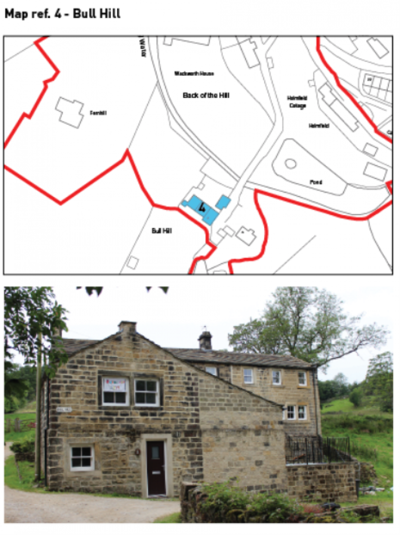
Map showing location of Bull Hill.
|
Feature name ( Map ref no.) |
Location |
Description |
Why is the feature of interest and significance? What evidence exists to support the proposed selection? |
|
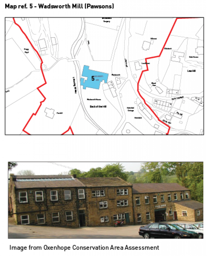
Wadsworth Mill (5) |
Wadsworth, Lower Town |
Former mill, first recorded in 1808. |
Wadsworth Mill (better known as George Emmott (Pawsons)) faces 1 Wadsworth gable-on. The oldest element of the mill is the three storey stone roofed central element which is probably the mill premises first recorded on this site in 1808. The blocked taking-in doors are visible on the upper floors which have an irregular fenestration of two and three-light mullioned windows in plain stone surrounds. The central windows in the groups of three are two-pane timber sashes and are flanked by what were probably originally fixed windows. Attached to the eastern gable is a mid-19th century five bay extension with a row of lights set in its slate roof. At the apex of its gable is a loading door with hoist and a well-recessed doorway accessed by an industrial iron staircase. A late 19th century eightbay extension completes the roadside elevation of Wadsworth Mill, which started out as a textile mill but has been used from the 1850s onward for the manufacture of springs by the same company, George Emmott (Pawsons) Spring Works for over 150 years. BASIS OF DESIGNATION: Age, Historical Association, Social and Communal Value |
|
Feature name ( Map ref no.) |
Location |
Description |
Why is the feature of interest and significance? What evidence exists to support the proposed selection? |
|
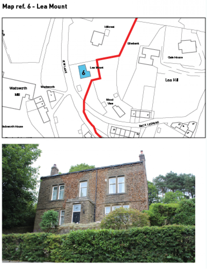
Lea Mount (6) |
Jew Lane, Lower Town |
Late Victorian Villa |
An attractive late Victorian villa built after 1892. The house has a modest symmetrical three bay arrangement with a central doorway with fanlight leading into a stone porch which is flanked by three mullioned single pane timber sash windows. A dripmould, which surmounts the lintels of the windows, also wraps around the porch. At first floor, mullioned pairs of timber sashes flank the central window. The coping and the corniced chimneys at the apex of either gable complete the symmetry. Other decoration includes an eaves band surmounted by paired gutter blocks. It retains many of its original features including front door and windows ensuring the building retains its historic appearance. BASIS OF DESIGNATION: Aesthetic Interest |
Map showing location of Lea Mount
|
Feature name ( Map ref no.) |
Location |
Description |
Why is the feature of interest and significance? What evidence exists to support the proposed selection? |
|
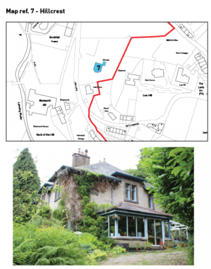
Hillcrest (7) |
Jew Lane, Lower Town |
Edwardian Arts & Crafts style house |
Marked with a pair of cylindrical stone gateposts with an entablature capped with ball capitals frame the entrance to Hillcrest, an Arts and Crafts style Edwardian house, built for a member of the Bancroft family, who owned Charles Mill. The overhanging rosemary red clay tile pavilion roof is carried on timber sprockets, although the bays of first floor windows break though and have small flat roofs. The walls are pebbledashed and the windows, including a bay window and many of mullioned groups, are set in slightly projecting plain stone surrounds while stonework on the angles gives Hillcrest a quoined appearance. The timber casement windows incorporate the lovely leaded stained glass panels of the original sashes. BASIS OF DESIGNATION: Aesthetic Interest, Social and Communal Value |
Map showing location of Hillcrest
|
Feature name (Map ref no.) |
Location |
Description |
Why is the feature of interest and significance? What evidence exists to support the proposed selection? |
|
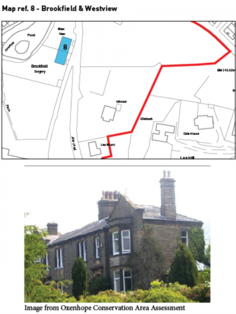
Brookfield & Westview (8) |
Off Jew Lane, Lower Town |
Brookfield and West View; a pair of houses built in the 1870s. The original building is the higher central element with a slate pavilion roof with a shared central corniced chimneystack. Below the gutter blocks, are single and paired single and two pane sash windows with slightly projecting cills and plain stone doorways beneath bracketed hoods. In the late 19th century the outer bays were added. Each of these has a gabled front with parapet and canted bays windows which extend up to the first floor. These houses were built for members of the Bancroft family, who from 1849 onwards were the owners of Charles Mill. BASIS OF DESIGNATION: Historical Interest, Social and Communal Value |
Map showing location of Brookfield & Westview
|
Feature name (Map ref no.) |
Location |
Description |
Why is the feature of interest and significance? What evidence exists to support the proposed selection? |
|
Cragg Royd & terrace (9) |
Off Meadowfield, Lower Town |
Substantial detached house |
Cragg Royd, a substantial detached house which was built in 1904 for a Mr Ogden, who had been a partner at Charles Mill since 1884 (Hindley, 2004). Its rendered walls contrast with the golden sandstone surrounds to openings and ashlar quoins. The off-centre panelled timber door is surmounted by a hood on brackets with a moulded profile which continues across the wall as a dripmould and extends across the two canted bay windows which flank the doorway. The rosemary red clay tile roof has crested ridge tiles and in its centre there is a dormer with three timber sash lights surmounted by bargeboards and a drop finial. The timber sash windows of the dormer are different in that they have multi-pane upper sashes while the rest of the windows have single pane upper sashes. Both of the corniced chimneys are made of stone. There is a stone terrace in front of Cragg Royd with a room underneath. The terrace has a golden sandstone balustrade and a central doorway and four bays of round-headed voussoired windows front the room below. BASIS OF DESIGNATION: Aesthetic Interest, Social and Communal Value |
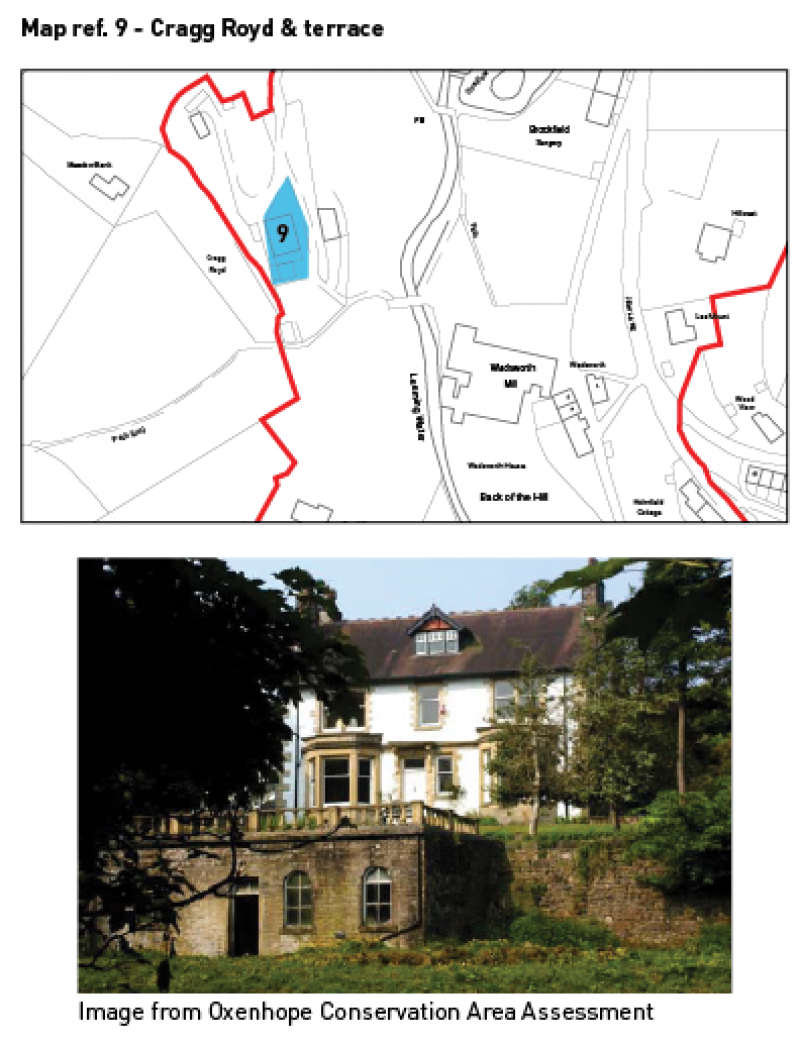
Map showing location of Cragg Royd
|
Feature name (Map ref no.) |
Location |
Description |
Why is the feature of interest and significance? What evidence exists to support the proposed selection? |
|
16-20 Hill House Lane (10) |
Hill House Lane, Lower Town |
Workers cottages |
These houses were built before the mill (Olde Mill, attached to no.20) and date from c.1810. Only number 18 retains the original fenestration of six flat-faced mullioned lights with plain stone surrounds over five on the ground floor, a typical arrangement for weavers' cottages. The doors are also set in plain stone surrounds although the recessing of the lintel within the doorway is an unusual feature. The corniced chimneys with chamfered ledges, panelled timber doors and the unpainted stonework help to unite this short row of houses. The eastern bay of number 16 was added in the late 19th century and presumably features the tabling and kneeler of the original gable end. BASIS OF DESIGNATION: GROUP VALUE |
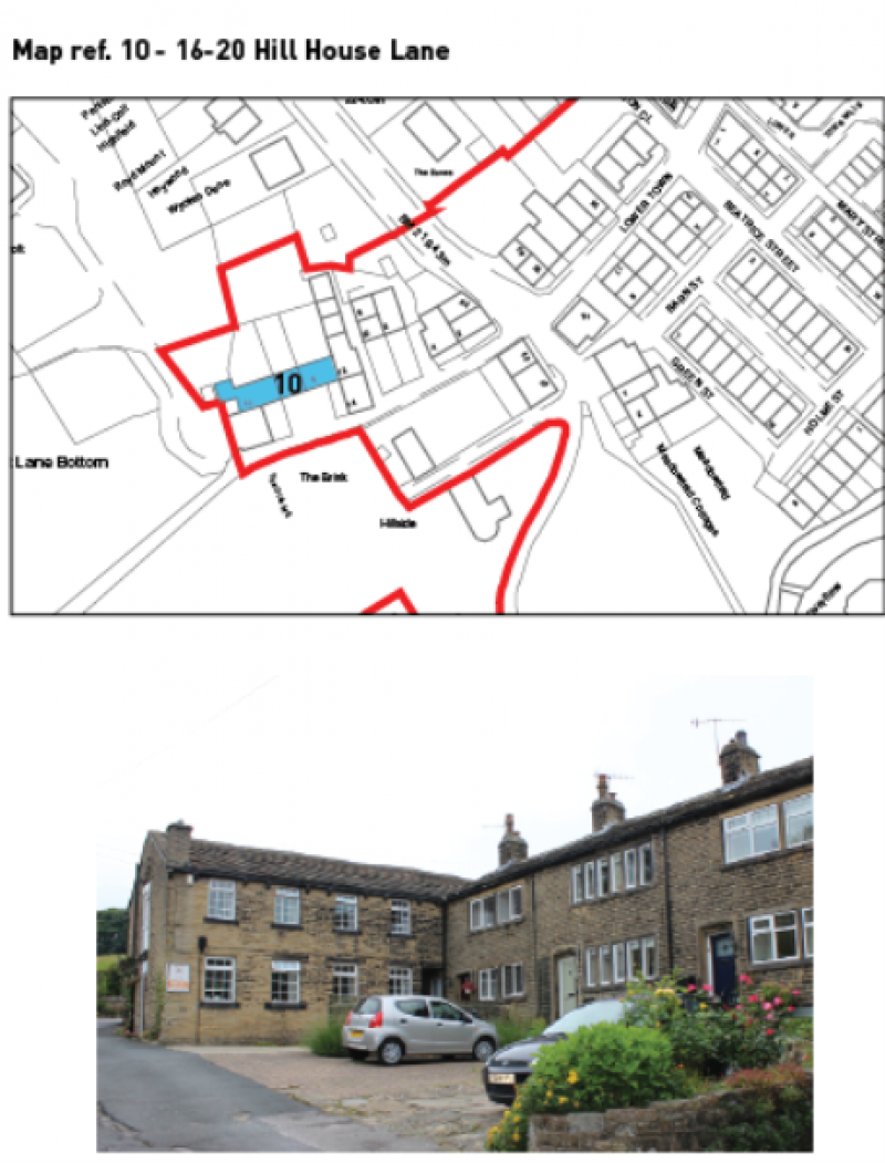
Map showing location of 16-20 Hill House Lane
|
Feature name (Map ref no.) |
Location |
Description |
Why is the feature of interest and significance? What evidence exists to support the proposed selection? |
|
Ashdene (11) |
Yate Lane, Station Road Conservation Area |
Large detached Arts & Crafts style house |
Ashdene, an Arts and Crafts style villa dated 1908, stands behind an ashlar gateway with an iron gate and a high garden wall with flat-topped moulded coping. Although pebble dashed and lacking its original windows, the use of stone mullioned windows with moulded lintels and a stone base with ashlar quoins means Ashdene contributes to the overall unity of Station Road. The timber bargeboards and a roof which overhangs these eaves are typical of the style. BASIS OF DESIGNATION: Aesthetic Interest, Rarity |
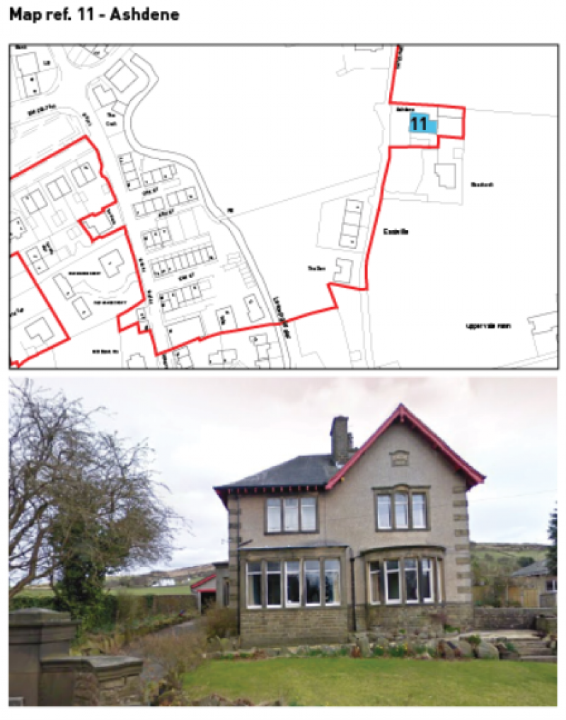
Map showing location of Ashdene
|
Feature name (Map ref no.) |
Location |
Description |
Why is the feature of interest and significance? What evidence exists to support the proposed selection? |
|
Oxenhope Railway Station (12) |
Mill Lane, Station Road Conservation Area |
Historic Railway |
The station building is H-plan and appears to have been built in two stages as the northern wing and the central block sit on an ashlar plinth and is Italianate in style, while the northern wing has a different fenestration and overhanging eaves with bargeboards. The former wing with entrance hall was probably added when Midland Railway took over the branch railway in 1881. The line opened in 1867, funded predominantly by local wealthy mill owners. Within a very short time, the railway became part of the Midland Railway until in 1923 at the Grouping, it was absorbed into the new London Midland and Scottish Railway. Upon Nationalisation in 1948, the line became part of British Railways, and with its fortunes declining with the rise of competition from the roads, the branch closed in 1962. The line is currently run by a dedicated group of volunteers and is one of countries premier heritage railways. BASIS OF DESIGNATION: Archival Interest, Historical Association, Landmark Status, Social and Communal Value |
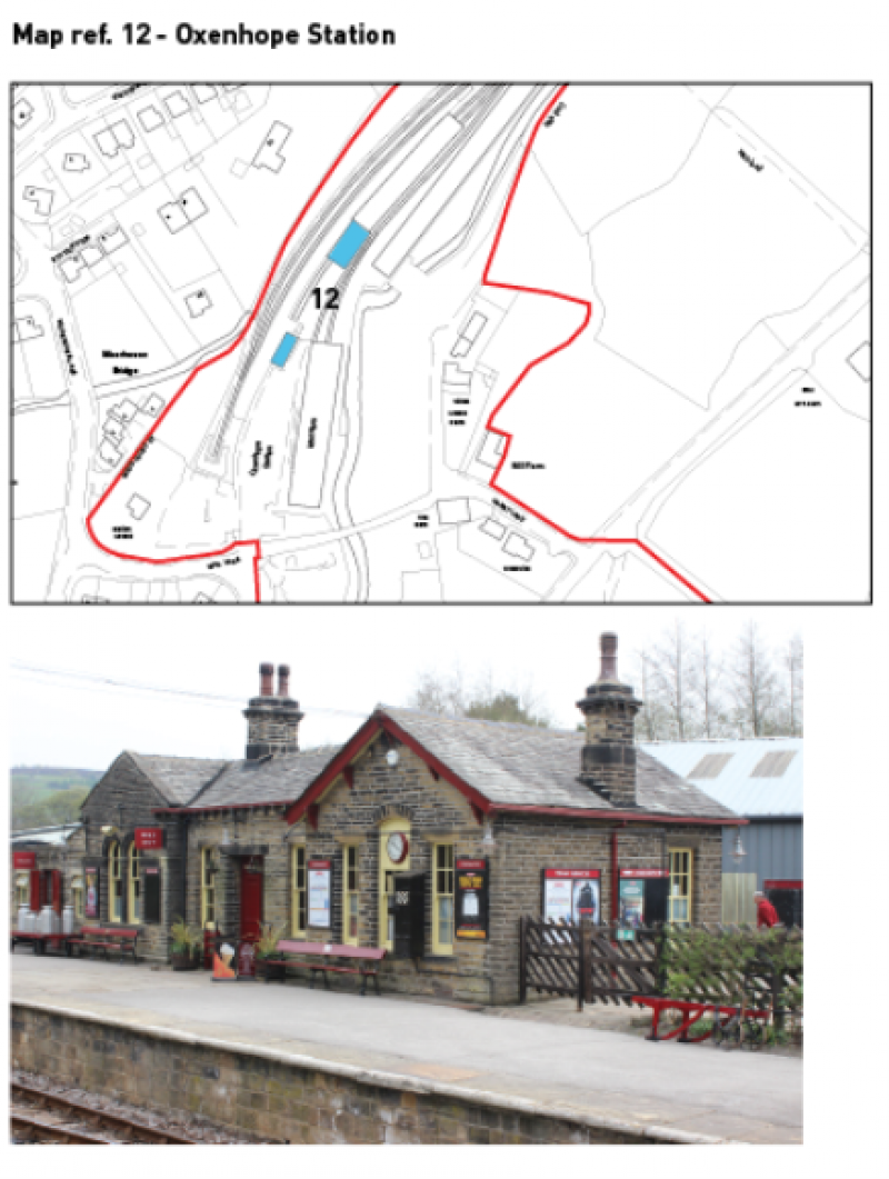
Map showing location of Oxenhope Station
|
Feature name (Map ref no.) |
Location |
Description |
Why is the feature of interest and significance? What evidence exists to support the proposed selection? |
|
Wilton House (13) |
Off Harry Lane & Mill Lane |
Detached former hunting lodge |
A small classically influenced house known as Wilton House, dated 1823 and bearing the same inscription 'The Rt. & Hon. The Earl of Wilton', the lord of Far Oxenhope, who was also lord of Denholme Manor, but resided in Wiltshire, apparently used this modest house as a hunting lodge. In later years Wilton House was used as the offices to the adjacent and since-demolished Oxenhope Mill. The symmetrical three bay front features a six panelled central door with Regency style astragal mouldings which is flanked by a bay of two pane timber sash windows set in plain stone surrounds. A first floor cill band, corniced chimney and kneelers are the only other elements of decoration on this austere looking lodge. BASIS OF DESIGNATION: Age, Social and Communal Value |
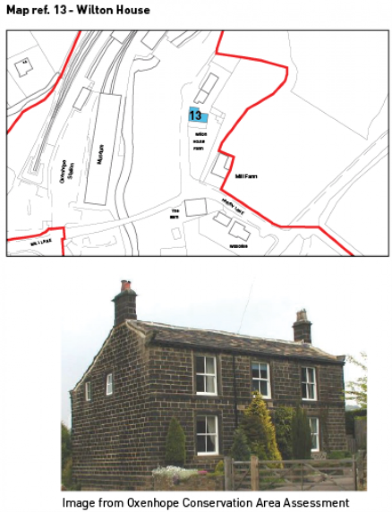
Map showing location of Wilton House
|
Feature name (Map ref no.) |
Location |
Description |
Why is the feature of interest and significance? What evidence exists to support the proposed selection? |
|
The Croft (14) |
Station Road |
Detached early 20th century house |
The Croft, a stylish early 20th century house, built by James William Greenwood who moved from Rose Bank to this house c.1910. It has flat faced mullioned windows with leaded glazing and Art-Deco stained glass tops and the original central stone porch to the left of which is a five-light bay window. The slate roof is coped and overhangs the front elevation on timber sprockets. The Croft is adjacent to the Rose Garden and contributes to the setting of the green space. BASIS OF DESIGNATION: Designated Landscape Interest, Aesthetic Interest |
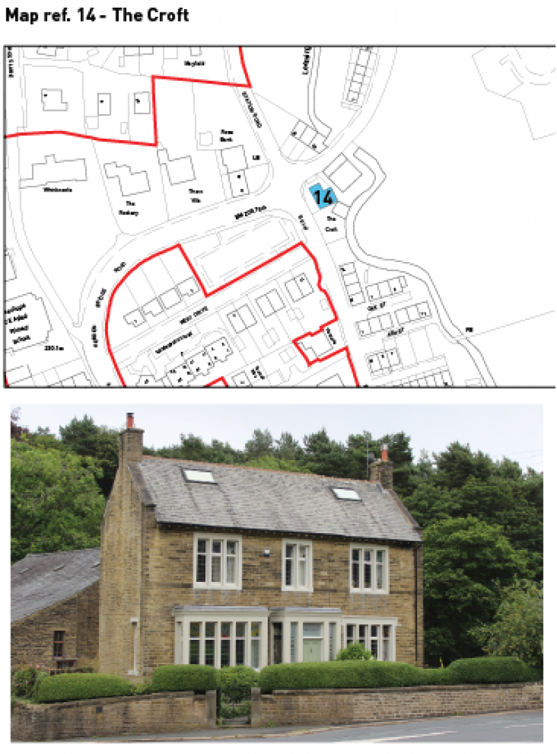
Map showing location of The Croft
|
Feature name (Map ref no.) |
Location |
Description |
Why is the feature of interest and significance? What evidence exists to support the proposed selection? |
|
Rose Bank (15) |
Station Road |
Substantial house and former warehouse |
Rose Bank a substantial house with attached warehouse built c.1873 for Mr Greenwood, a local corn merchant who built all of the other properties overlooking 'Muffin Corner' allegedly so named after the muffins made by his firm. The house has a symmetrical façade with an Italianate arched doorway with fanlight set within a pilastered doorcase with hood flanked by full height canted bay windows which are topped by their own pyramidal roofs. The slate pavilion roof of the house has open crested ridge decoration. Two moulded stone bands separate the floors and an entablature wraps around the entire house, a motif which is repeated on the chimneys.
BASIS OF DESIGNATION: Social and Communal Value |
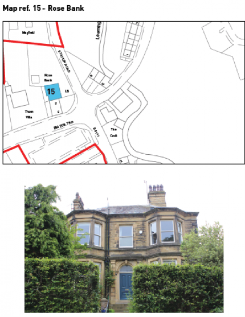
Map showing location of Rose Bank
|
Feature name (Map ref no.) |
Location |
Description |
Why is the feature of interest and significance? What evidence exists to support the proposed selection? |
|
Thorn Villa (16) |
Hebden Bridge Road |
Large home to former Oxenhope businessman |
Thorn Villa, the home of another wealthy Oxenhope businessman, Thomas Feather, a textile manufacturer at Holme Mill and Lower Town Mill, built c.1872. Built in a Classical style, this almost cubic house has a central doorcase framed by pilasters with the window above and flanking bay containing single pane timber sash windows set in eared architraved surrounds. A first floor cill band, eaves band and modillion brackets wrap around the entire house and supports cast iron guttering. The chimneys, set behind the slate pavilion roof, feature a similar entablature. To the rear of the house is an unaltered coach house with elements of the stabling and is thus quite a rare survival. Its small front gable contains pigeonholes. The gateway to Thorn Villa consists of two monolithic gatepiers with pyramidal capitals. BASIS OF DESIGNATION: Social and Communal Value |
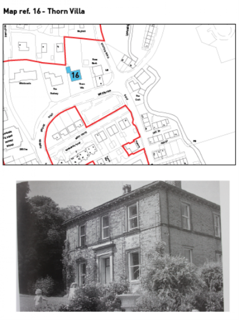
Map showing location of Thorn Villa
|
Feature name (Map ref no.) |
Location |
Description |
Why is the feature of interest and significance? What evidence exists to support the proposed selection? |
|
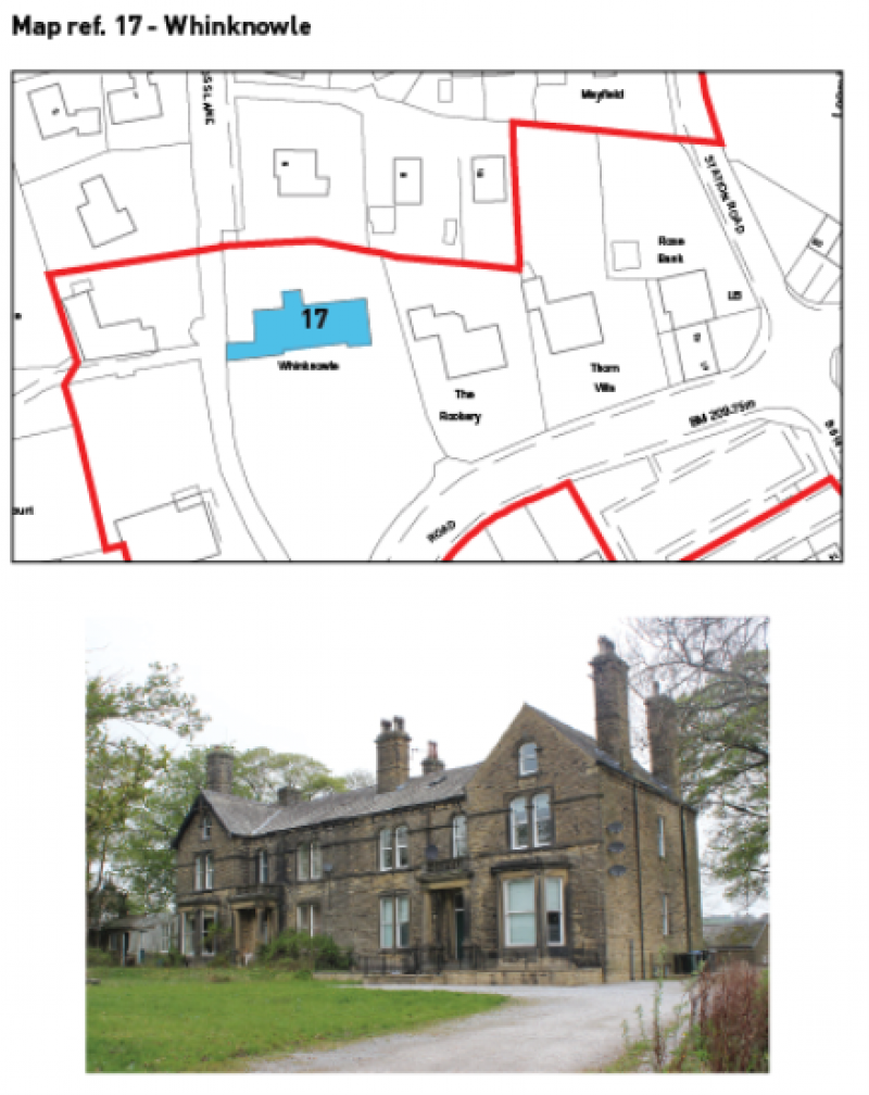
Whinknowle (17) |
Hedben Bridge Road |
Two semi-detached villas |
Whinknowle has a gateway with impressive monolithic gatepiers with arched panels and corniced caps. This was formerly the entrance to one of the two semi-detached villas of Whinknowle, built in the early 1870s for local textile manufacturers Thomas Parker and Son, worsted spinners of Holme Mill. With a separate entrance for father and son, the interesting six-bay symmetrical vaguely Italianate façade has a first floor cill band and paired semi-circular-arched windows with impost and keystone at first floor level on the main block. The projecting two-and-half storey outer bays are gable fronted with canted bay windows at ground floor, two-light camber-headed windows above and a single arched light set at the apex of the gable above. Only the western bay retains its overhanging roof and timber bargeboards with drop finials. In the second and fifth bays are open porches with tapering Doric pilasters supporting the porch roof and a stone balustrade above. Very few of the single pane sash windows have been replaced (none at all on the front elevation) and the rear stairlights with coloured margin panes are still in place. To the rear of the western house is a three-storey high embattlemented turret, which was once a highly prominent feature of the skyline of the village when viewed from Oxenhope Station. Whinknowle remained the residence of the owners of Thomas Parker and Son Ltd into the mid-1960s, by which time the firm was based in Keighley. BASIS OF DESIGNATION: Social and Communal Value, Aesthetic Interest |
Map showing location of Whinknowle
|
Feature name (Map ref no.) |
Location |
Description |
Why is the feature of interest and significance? What evidence exists to support the proposed selection? |
|
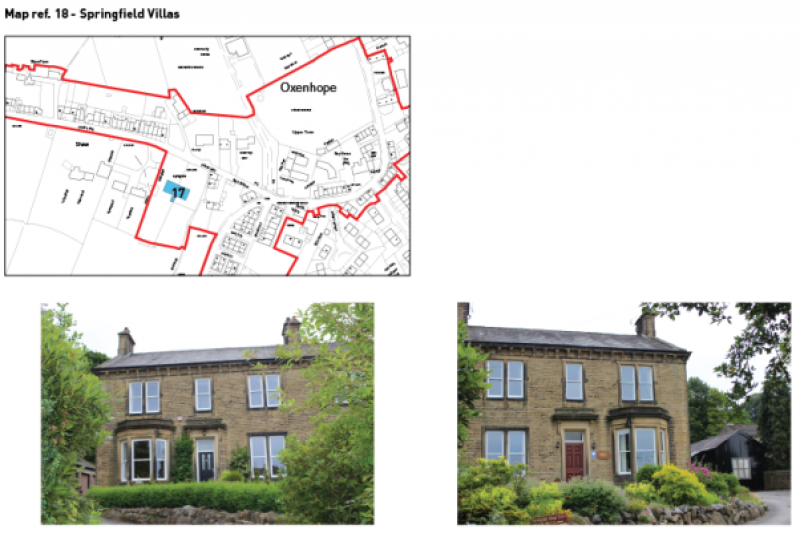
Springfield Villas (18) |
Shaw Lane |
Impressive twin villas |
Across Shaw Lane from Holme Lea, but equally set back are the impressive twin villas of Springfield which date from 1874 and are arranged in a symmetrical fashion, similar to Whinknowle. They were built for the Speak family, who presumably owned or were partners in Brooks Meeting Mill at the time. In later years, the houses were occupied by the Denby family, partners in mills in Lower Town who in 1931-2 provided the site for Oxenhope Park. The long slate roof is coped with a corniced chimney at the apex of either gable with a third chimney indicating the position of the party wall of the villas. Directly below the roof is a stone gutter supported by modillion gutter brackets set in an eaves band. The second and fifth bays contain the doorway to each respective villa which consist of a bold monolithic doorcase below a bracketed hood with parapet. The same parapet is found on the canted ashlar bay windows in the first and sixth bays. The rest of the windows are set in eared projecting plain stone surrounds as singles or in mullioned pairs. All of the windows are the original single pane painted timber sashes. To the rear are more original details, most notably the large round-headed stairlight with etched glass and stained margin lights. BASIS OF DESIGNATION: Social and Communal Value, Aesthetic Interest |
Map showing location of Springfield Villas
|
Feature name (Map ref no.) |
Location |
Description |
Why is the feature of interest and significance? What evidence exists to support the proposed selection? |
|
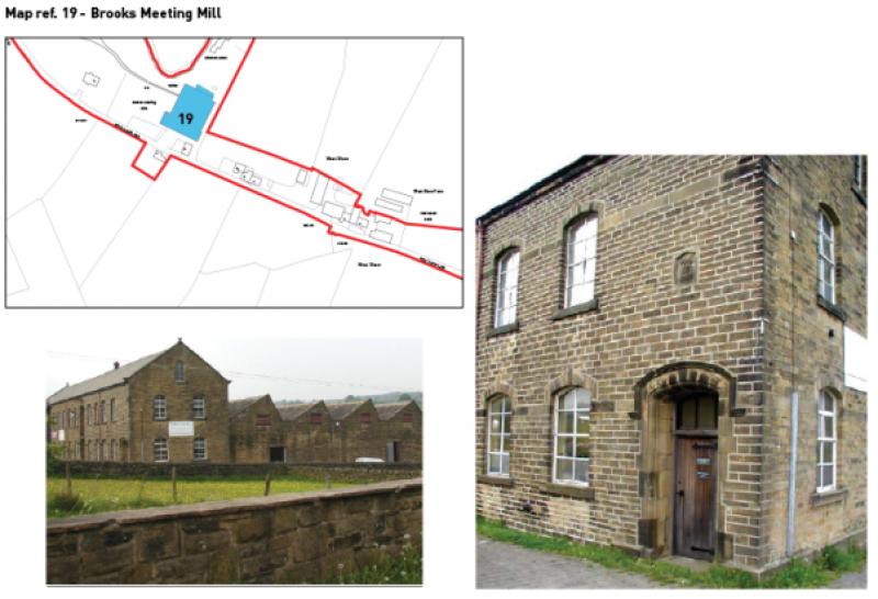
Brooks Meeting Mill (19) |
West Shaw Lane |
Dominant historic mill building |
Brooks Meeting Mill is a dominating building with a 15 bay, two-and-a-half storey mass . The mill was established at an unknown date prior to 1817 on the site of the present day Brook House and was still on this site in 1847-8. The mill was substantially extended in the 1880s and again in 1910. The three storey spinning mill element (presumably the older elements of the mill complex) burnt down in 1916 and was not replaced, leaving only the 1880s and 1910 elements. The 1910 shed runs parallel to the lane and is surprisingly still in commercial use and more or less unchanged externally. 14 bays contain tall segmental-headed industrial windows with flush voussoirs. Bay 10 is a similarly style loading bay with a tall timber board door at first floor level. The 15 bay contains the segmental-headed main doorway with architraved jambs and voussoirs with a moulded hoodmould above. Above the doorway is a date plaque. The long slate roof is coped at either end with a ball finial presiding at the apex. Halfway along the ridge is and iron flue. This building replaced an earlier shed which was built in the second half of the 19th century which burned down. It is attached to the shed is an older four bay weaving shed with a sawtooth profile and north lights. Behind this are an enginehouse and a boilerhouse which are contemporary with the 1910 shed. BASIS OF DESIGNATION: Social and Communal Value |
Map showing location of Brooks Meeting Mill
|
Feature name (Map ref no.) |
Location |
Description |
Why is the feature of interest and significance? What evidence exists to support the proposed selection? |
|
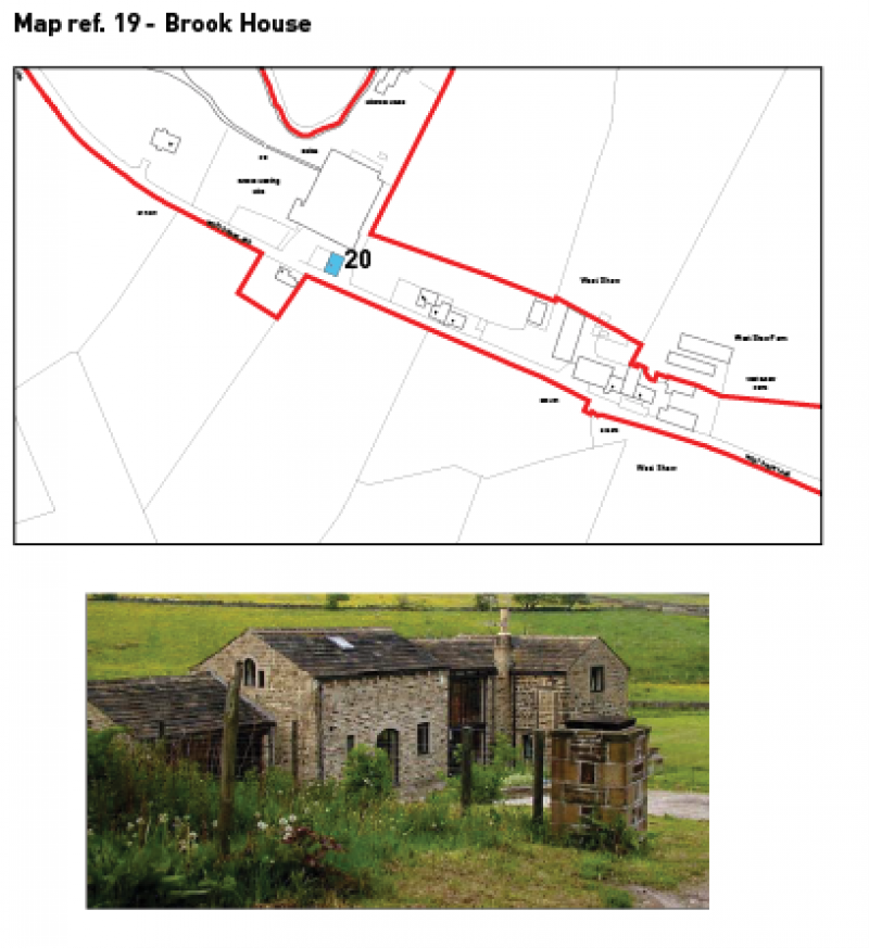
Brook House (20) |
West Shaw Lane |
Dwelling with former industrial links |
Brook House now occupies the initial/original site of Brooks Meeting Mill. This mysterious group of buildings does not appear to be on the ordinance Surveys of 1852 (unless it was part of the original Brooks Meeting Mill) or 1892. However, the blocked taking-in door at first floor level and the industrial looking chimney set within the angle of the buildings suggest that its was used in the manufacture of textiles. This industrial looking building is linked to what appears to be an old barn by two storeys of dark glazing beneath a pitched stone roof, an attractive integration of old and modern. The barn has a keyed segmental cart entrance flanked by two plain stone windows. At first floor level are three ventilators, while the gable is lit by a Venetian window near its apex. The stonework around the openings, their proportions and the appearance of the roofs suggest that Brook House has been extensively rebuilt, perhaps even newly built using reclaimed stone BASIS OF DESIGNATION: Social and Communal Value |
Map showing location of Brook House
6.2 LOCAL GREEN SPACE ASSESSMENTS
Local Green Spaces are designated sites that are protected from development due to the contribution they make to the local area. There is specific criteria for designating sites (NPPF Para 100) so not all green spaces are suitable for Local Green Space listing. The listing criteria is shown below:
Paragraph 100 of the NPPF states that the designation should only be used.
The Local Green Space designation should only be used where the green space is:
- in reasonably close proximity to the community it serves;
- demonstrably special to a local community and holds a particular local significance, for example because of its beauty, historic significance, recreational value (including as a playing field), tranquillity or richness of its wildlife; and
- local in character and is not an extensive tract of land.
The above criteria has been used to filter suggested sites and to provide a recommendation as to whether or not they should be designated.
Also included in this appendix are suggested LGS sites that have been 'filtered' out because they did not sufficiently satisfy the relevant criteria.
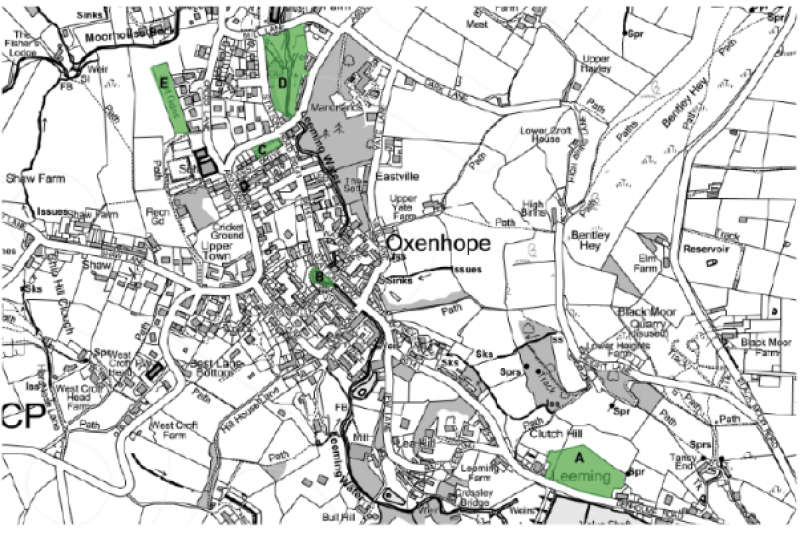
Map of proposed Local Green Spaces for Policy GS1
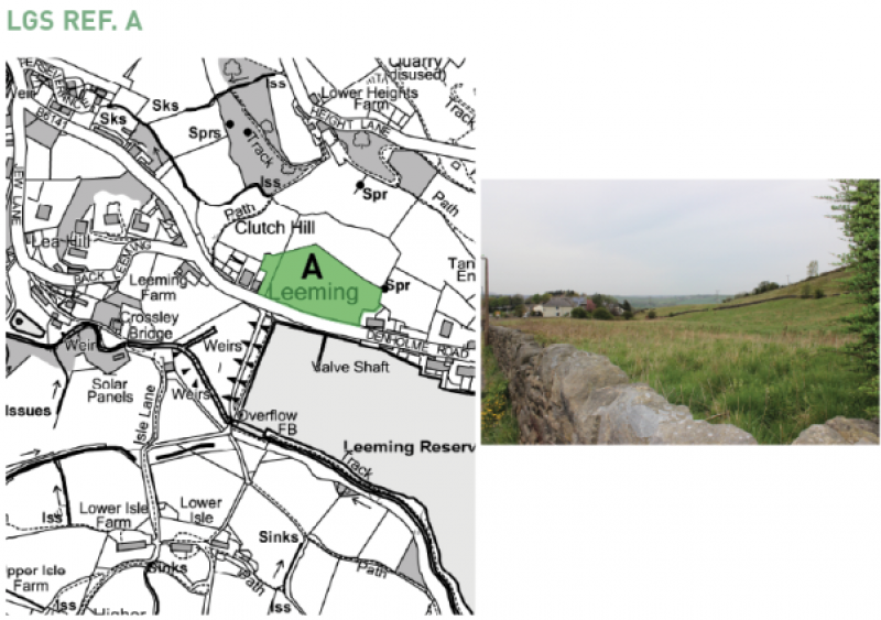
- Leeming Field
Location: Off Denholme Road, opposite Leeming Reservoir
Size: 0.86ha
Proximity to community served (ref NPPF 100a):
Site is within the settlement limits and the area has dwellings built in a linear form to both the east and west of the site. It is within proximity to the community it serves.
Local in character / not an extensive tract of land (ref NPPF 100c):
Site is local in character. Oxenhope is defined as a series of settlements separated by open green space and this green space contributes to that, sitting between Leeming and Lower Town. The site is 0.86ha.
Landscape significance (beauty, tranquillity), Historic significance, Recreational value, Wildlife richness (ref NPPF 100b):
Designated as village green space in the RUDP. The site is listed as a key open space in the Leeming Conservation Area Appraisal and as an 'area that provides a positive contribution to the character' of the conservation area. The site contributes to local wildlife and biodiversity and is within a few meters of sites designated as Bradford Wildlife Habitat Network. On the West Yorkshire ecology species map the site is marked as being a home to two species of birds (although does not say which ones). The site is opposite Leeming Reservoir which was constructed in 1872 and is directly behind the valve tower which is of local historical significance and contributes to the setting of the reservoir.
Summary Assessment: Given the sites designation as village green space in the RUDP, its listing as a key open space in the Leeming Conservation Area Appraisal, and as an area that makes a positive contribution to the character of the area it is considered that this space is of landscape significance due to its beauty and potentially its wildlife richness.
Recommendation: Designate as Local Green Space
Map of Local Green Space Site A – Leeming Field
- Horseshoe Dam
Location: Station Road
Size: 0.1ha
Proximity to community served (ref NPPF 100a):
Located in the heart of the village, surrounded by residential properties.
Local in character / not an extensive tract of land (ref NPPF 100c):
The space is local in character and is not an extensive tract of land.
Landscape significance (beauty, tranquillity), Historic significance, Recreational value, Wildlife richness (ref NPPF 100b):
Designated as a key open space in the Lower Town Conservation Area Appraisal and as 'an area that makes a positive contribution to the character' of the area. Horseshoe Dam is a small site currently used for flood mitigation and contributing to wildlife and biodiversity in the centre of the village.
It is of landscape significance due to both its beauty and tranquillity and its wildlife richness.
Summary Assessment: Given its listing as a key open space in the Lower Town Conservation Area and as 'an area that makes a positive contribution to the character of the area' it is considered that Horseshoe Dam is of landscape significance due to its beauty and tranquillity. It also supports local wildlife and biodiversity and is locally referred to as the 'duck pond'. The site is managed and maintained regularly by local volunteers.
Recommendation: Designate as Local Green Space
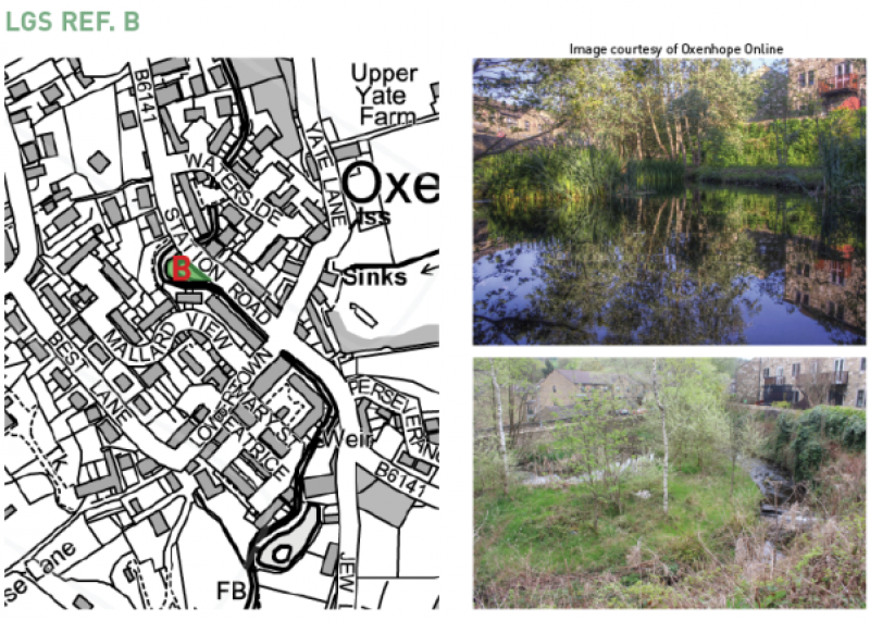
Map showing location of Local Green Space Site B – Horsehoe Dam
- Rose Garden
Location: Corner of Station Road & Hebden Bridge Road
Size: 0.12ha
Proximity to community served (ref NPPF 100a):
Located in the heart of the village, surrounded by residential properties.
Local in character / not an extensive tract of land (ref NPPF 100c):
The space is local in character and is not an extensive tract of land.
Landscape significance (beauty, tranquillity), Historic significance, Recreational value, Wildlife richness (ref NPPF 100b):
Designated as Key Open Space in Station Road Conservation Area Appraisal, and as 'an area that makes a positive contribution to the character of the area'. It includes a 'Key View' and 'Important Trees/Woodland'.
Rose Garden has recently been adopted by the Friends of Oxenhope Rose Garden who oversee the ongoing maintenance and management of the space. The space provides amenity and recreational space for members of the community and visitors. It therefore has landscape significance due to its beauty and tranquillity, and its recreational value.
Summary Assessment: Due to the listings in the Station Road Conervation Area Appraisal and the important role this space plays in the day to day lives of the community it must be considered this site has landscape significance and is important due to its recreational value.
Recommendation: Designate as Local Green Space
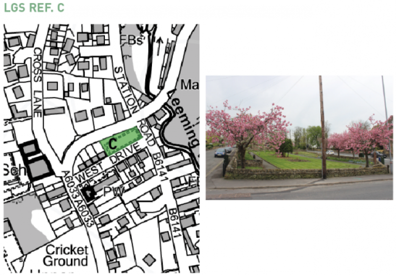
Map of Local Green Space Site C – Rose Garden
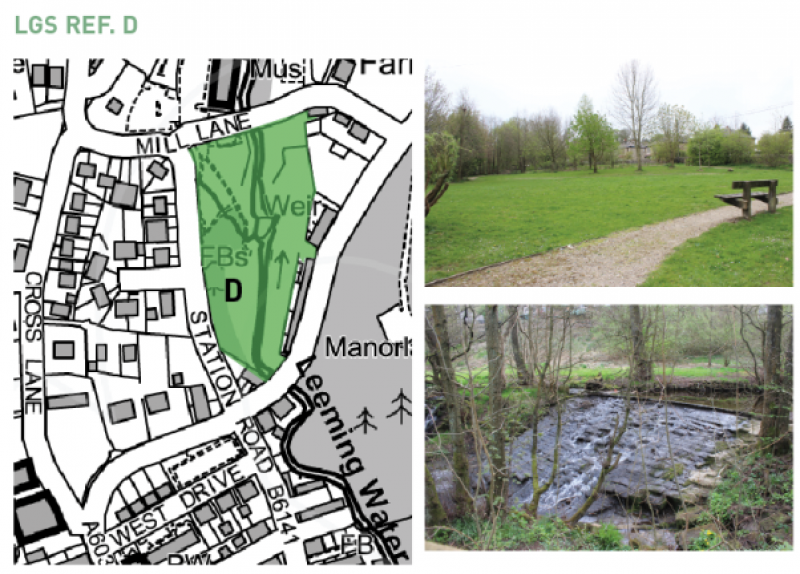
- Millennium Green
Location: Station Road
Size: 0.46ha
Proximity to community served (ref NPPF 100a):
Located in the centre of the village, with many residential properties surrounding the site.
Local in character / not an extensive tract of land (ref NPPF 100c):
Local in character and not an extensive tract of land.
Landscape significance (beauty, tranquillity), Historic significance, Recreational value, Wildlife richness (ref NPPF 100b):
Village Green Space and Site Important for Nature Conservation in RUDP.
Key Open Space in Station Road Conservation Area Appraisal, and listed as 'an area that makes positive contribution to character of area'. Also listed as 'Contains important trees/woodland' and contains two Key Views. It is also within the Bradford Wildlife Habitat Network.
The Millennium Green is at the heart of the village. It was purchased by the residents of Oxenhope with funding from the Countryside Agency, the Millennium Commission (a project supported by the National Lottery) and other donors to celebrate the Millennium. It provides a local space for recreation and events including the annual village fete.
Summary Assessment: Given the sites listings and designations in the RUDP, Bradford Wildlife Habitat Network and Station Road CAA it is considered the site plays a significant role in the village for its recreational value, landscape significance and wildlife richness.
Recommendation: Designate as Local Green Space
Map showing site Local Green Space Site D – Millennium Green
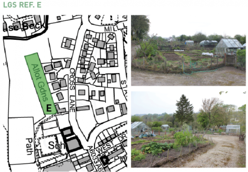
- Oxenhope Allotments
Location: West of Cross Lane
Size: 0.32ha
Proximity to community served (ref NPPF 100a):
The site is next to a variety of community facilities such as playing fields, cricket pitch, community centre and children's play area. It is bordered by residential properties to the east. It is considered in close proximity to the community it serves.
Local in character / not an extensive tract of land (ref NPPF 100c):
The site is local in character and is not an extensive tract of land. The allotments are well used and maintained by allotment holders. It is not an extensive tract of land.
Landscape significance (beauty, tranquillity), Historic significance, Recreational value, Wildlife richness (ref NPPF 100b):
The site is important locally for its recreational value. This is demonstrated by the high level of occupancy. The site may have some level of wildlife richness depending on what is being grown on the plots.
Summary Assessment: The site is local in character and is in close proximity to the community it serves. The site is demonstrably special to the local community due to its recreational value, this is reinforced by its popularity.
Recommendation: Designate as Local Green Space
Map showing Local Green Space Site E – Oxenhope Allotments
Policies map ref. DS1
Location: Land to west of Moorhouse Lane & Marsh Lane junction
Size: 0.76ha
Proximity to community served (ref NPPF 100a):
The site is immediately north of the village's development limits and the main settlement. There are both residential and agricultural buildings in close proximity to the south and west.
Local in character / not an extensive tract of land (ref NPPF 100c):
The site is local in character, being a small agricultural field bounded by traditional stone walls and is not an extensive tract of land.
Landscape significance (beauty, tranquillity), Historic significance, Recreational value, Wildlife richness (ref NPPF 100b):
The site is within the green belt so is already afforded a level of protection.
The site does not possess wildlife richness and is outside of the Bradford Wildlife Habitat Network. The site is not within a conservation area. Due to the topography of the site and surrounding area it does provide high quality views over the village of the wider valley.
Summary Assessment: Despite the site enabling views over the village and the wider valley the overall level of landscape significance and wildlife richness is low. This is because the site is outside of a conservation area, the Bradford Wildlife Habitat Network and is of low to average quality, used primarily for agricultural purposes.
Recommendation:DO NOT DESIGNATE AS LOCAL GREEN SPACE
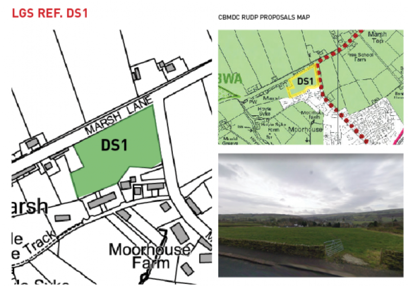
Map showing discounted site DS1 off Marsh Lane
(Policies map ref. DS2
Location: Land to east of Moorhouse Lane & Marsh Lane junction
Size: 0.39ha
Proximity to community served (ref NPPF 100a):
The site is immediately north of the village's development limits and the main settlement. There are both residential and agricultural buildings in close proximity to the south, west and north.
Local in character / not an extensive tract of land (ref NPPF 100c):
The site is local in character, being a small agricultural field bounded by traditional stone walls and is not an extensive tract of land.
Landscape significance (beauty, tranquillity), Historic significance, Recreational value, Wildlife richness (ref NPPF 100b):
The site is within the green belt so is already afforded a level of protection.
The site does not possess wildlife richness and is outside of the Bradford Wildlife Habitat Network. The site is not within a conservation area. Due to the topography of the site and surrounding area it does provide high quality views over the village of the wider valley.
Summary Assessment: Despite the site enabling views over the village and the wider valley the overall level of landscape significance and wildlife richness is low. This is because the site is outside of a conservation area, the Bradford Wildlife Habitat Network and is of low to average quality, used primarily for agricultural purposes.
Recommendation:DO NOT DESIGNATE AS LOCAL GREEN SPACE
Map showing discounted site DS2