Harden Neighbourhood Development Plan - Regulation 16 Consultation
3. TRANSPORT & MOVEMENT
3.0 INTRODUCTION
3.0.1 Harden aspires to being a community where people can access opportunities easily, and get around in healthy and sustainable ways, benefiting themselves, others and the environment. The community wants to be well- connected to employment, education and leisure opportunities, while also reducing traffic noise, pollution and congestion, especially by enabling more people to walk, cycle and use public transport.
3.1 KEY OBJECTIVES
- Work towards better management of traffic, speeding and parking issues that negatively affect the community.
- Improve pedestrian and cycle infrastructure and support and enable greater use of sustainable and healthy transport methods, and greater mobility for all.
This part of the plan will also contribute to these wider aims:
- Encourage and support more sustainable living, striving towards being carbon- neutral.
- Preserve and enhance green spaces and heritage assets for everyone to enjoy now and in the future.
3.2 KEY ISSUES
Community engagement, consultation, and discussions by the Neighbourhood Planning group, and a review of local data and wider evidence identified five issues to focus on:
- Public transport links
- Traffic volume, noise and pollution
- Speed and safety
- Problem parking
- Pedestrian connectivity
POLICY HNDP7: HARDEN TO BINGLEY ACTIVE TRAVEL
Enhanced walking and cycling infrastructure connecting Harden to Bingley is required and will be sought.
3.2.1 This policy gives support to the provision of enhanced walking and cycling connections from Harden to Bingley – Harden's closest major conurbation. At present the primary connection along Harden road is meagre, and in places is unsafe and unwelcoming. To the east of Woodbank Nurseries only the southern side of the road has pavements.
3.2.2 The width of the pavement is narrow and restricts users to travel in single-file. People with pushchairs, wheelchair, or mobility scooters are unlikely to be able to use the route safely at all.
3.3.3 Walking or cycling along Harden Road can also be intimidating due to the high speed and volume of traffic. This policy supports the aims and objectives of the plan by seeking to provide safer and healthier options of travel to Bingley, which boasts public transport connections to the wider area.
3.3.4 It is anticipated that this will be scoped and delivered by a local project involving the Village Council and other key stakeholders such as landowners. The NDP is unable to provide an indicative route at this time.
This policy seeks to achieve aims & objectives 5.
This policy aligns with CBMDC adopted core strategy 2017 policies PN1 (E.4), TR1 (E).
POLICY HNDP8: ELECTRIC VEHICLE CHARGING POINTS
Support is given to new housing developments that provide on-site electric vehicle charging points.
3.3.5 To promote more sustainable travel habits the Neighbourhood Plan supports and encourages the inclusion of electric vehicle charging points in new housing developments. The preferred location of these is outside of the property.
3.3.6 It is expected that the use of electric vehicles will increase in the near future and Harden aims to secure the infrastructure needed to support this. Increased use of electric vehicles can help reduce carbon emissions and reduce the noise of traffic which are contained in the aims and objectives for the Plan.
This policy seeks to achieve aims & objectives 1, 2, 5.
This policy aligns with CBMDC adopted core strategy 2017 policy TR1.
POLICY HNDP9: PARKING SOLUTIONS
New residential developments should comply with design guidance contained in the plan to produce design-led street layouts and parking solutions that provide:
- high quality and secure on-site cycle storage,
- the minimum expected amount of parking spaces in line with Bradford Council standards, and appropriate visitor parking bays, where necessary,
- garages and driveways to the rear or side of properties in the same style as the house they serve, with suggested internal dimension of the garages 3.5m x 6m and driveways a minimum of 3.5m in width.
3.3.7 Applicants should refer to Bradford Council's Homes and Neighbourhood Design Guide SPD which includes advise on parking provision as part of new developments. Engagement responses cited problem parking as a key issue in the village and new residential developments should not exacerbate the problem.
3.3.8 Some garages locally are not large enough to store cars - so the Plan proposes internal dimensions in line with Lifetime Homes standards that will enable residents to park and enter/exit the vehicle both on the driveway and in the garage. This policy responds to the aims and objectives of the Plan by promoting and enabling more sustainable travel habits through the inclusion and promotion of pedestrian and cycle infrastructure whilst also aiming to reduce issues around problem or inconsiderate parking through requiring adequate parking and garaging solutions.
This policy seeks to achieve aims & objectives 2, 3, 5.
This policy aligns with CBMDC adopted core strategy 2017 policy TR2.
POLICY HNDP10: PEDESTRIAN & CYCLE CONNECTIONS
All new developments will be expected to connect with existing footpaths and cycle paths, where available, and where possible, improve the network. Developments should allow for safe and convenient pedestrian and cycle movement to local facilities, shops, schools and public transport connections.
3.3.9 This policy seeks to ensure that new developments are well connected to pedestrian and cycle connections. It responds to the aims and objectives of the plan which promote safe and convenient pedestrian and cycle movement throughout the village and to the wider area.
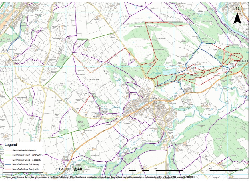
3.3.10 A map of definitive and non-definitive footpaths and bridleways can be found overleaf.
This policy seeks to achieve aims & objectives 5.
This policy aligns with CBMDC adopted core strategy 2017 policy PN1
Map of Footpaths and Bridleways