Harden Neighbourhood Development Plan - Regulation 16 Consultation
6. HERITAGE
6.0 INTRODUCTION
6.0.1 Excavations on Leech Lane led to discoveries of pottery, coins and elephant ivory which suggest Harden was once a Roman settlement around 150 AD. The first written record of Harden is in the Domesday Book of 1086 written as 'Hateltone' or 'Hateltun. Presently, there are some examples of buildings dating back to the 17th century with many more examples from the 18th and 19th centuries.
6.0.2 Harden, like many settlements in the area was predominantly home to agricultural workers, and later, mill workers. Many of these buildings are still
present today, although most now serve alternative uses, such as residential and have been altered over time, meaning many no longer contain all of their original architectural features.
6.0.3 The Neighbourhood Plan seeks to protect heritage assets, and supports their sensitive enhancement and restoration. Listed buildings and monuments are sufficiently covered and protected by national and local planning policy so these are not addressed in this section.
6.1 COMMUNITY ENGAGEMENT IDENTIFIED THAT:
- 43 people felt the Neighbourhood Plan should promote heritage and conservation
- Retaining the character of the village was the most popular response when people were asked what Harden should be like in 15 years with 34 responses
6.2 KEY OBJECTIVES
- Conserve local heritage and ensure new developments are in keeping with the local character
- Promote sensitive enhancement and /or restoration of non-designated heritage assets
ST IVES ESTATE
6.2.1 St Ives Estate is a 550 acre Grade II Listed historic park and gardens containing a variety of buildings of historical interest. The estate is highly valued locally and regionally as a place of recreational, ecological and heritage value.
6.2.2 St Ives estate is a Local Wildlife Site and is within the Bradford Wildlife Habitat Network. The estate comprises ancient semi-natural woodland, deciduous woodland, and lowland fens which support a variety of flora and fauna. Within the estate are locally significant artefacts such as Lady Blantyre's Rock and the William Busfeild Ferrand Obelisk Monument - two memorials built in honour of former residents of the estate.
6.2.3 St Ives is well used by residents and visitors – attracting around 300,000 visitors annually including walkers, bird watchers, anglers, horse riders. The estate includes public amenities such as a large children's play area, a café, and public toilets.
6.2.4 There are 14 listed buildings or monuments within the estate including Old Harden Grange a country house dating back to early to mid 17th Century and St Ives Mansion House dating back to mid to late 19th Century. Also within the estate are residential properties, several business premises, St Ives golf course, and St Ives discovery centre.
6.2.5 The Neighbourhood Plan will work closely with Bradford Council and the many stakeholders involved in the estate, including the Friends of St Ives, a local group promoting activities on the estate, whilst aiming to conserve its traditions.
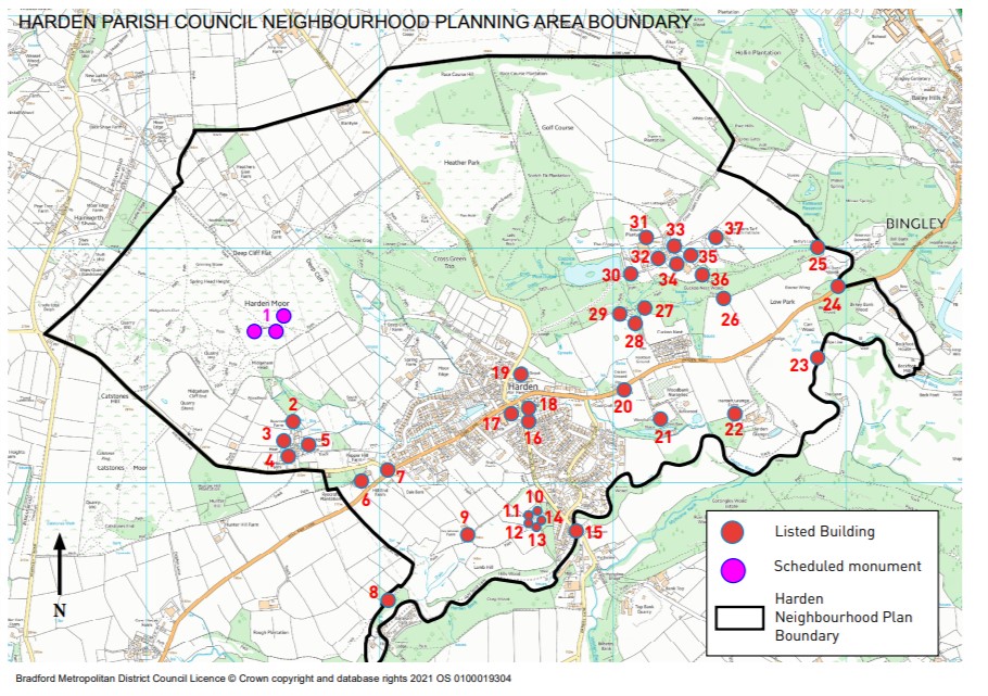
6.2.6 List of listed buildings / monuments:
- Cairns
- Ryecroft Farmhouse
- Barn immediately to the north of no.13 Ryecroft
- 13 Ryecroft
- Ivy House Farmhouse (Ryecroft)
- Hill End farmhouse
- Hostel Stone
- Goit stock cottages
- Ivy House Farmhouse (Harden)
- Harden Hall
- Garden wall and mounting block attached to south front of Harden Hall
- Entrance gatepiers and wall with balcony attached to barn aproximately 10 metres east of Harden Hall
- Barn approximately 10 metres east of Harden Hall
- Barn approximately 25 metres south east of Harden Hall
- Harden Beck Bridge
- Harden Wesleyan Methodist Church
- Harden War Memorial
- Harden Congregational Church
- 2-3 Crowther Fold
- Ferrands Stone
- Wood Bank
- 22. Stable block architecture Harden Grange Farm
- Footbridge over Harden Beck
- Entrance gate piers to St Ives Estate
- Betty's Lodge
- Barn Low Park
- Outbuilding approximately 15 metres north east of number 3 Cuckoo Nest
- Steps, gate piers and flanking walls to front of Cuckoo Nest
- Cuckoo Nest
- Footbridge approximately 10 metres east of coppice pond
- Dutch barn to rear of the home farm building at St Ives
- Wall to rear of the cottage at Old Harden Grange forming walled garden
- The cottage attached at right angles to north west corner of Old Harden Grange
- Wall attached to south front of the cottage at Old Harden Grange
- Old Harden Grange
- St Ives Mansion House
- The stable block used by Turf Research Institute
MAP 7 - Listed buildings and scheduled monuments
POLICY HNDP19: HERITAGE
New developments will be expected to respect and protect non-designated heritage assets and their settings. The level of protection should be commensurate to the level of designation of the asset.
The development or alteration of a non-designated heritage asset should be undertaken sensitively, respecting the historical and architectural integrity of the buildings. Proposals to restore non-designated heritage assets and original features will be supported, providing all other material planning considerations are satisfied.
The following buildings and structures are to be included as Non- designated heritage assets (refer to Harden Neighbourhood Plan Non Designated Heritage Assets Assessment document for methodology and justifications) :
- Old Police House, Keighley Road
- 1, 1a, 3, 5, 7, 9 Keighley Road & 10, 12 Long Lane
- Telephone Box, off Keighley Road/Long Lane
- St Saviour's Church, Long Lane
- Harden Primary School, Long Lane
- Shops adjacent to the Golden Fleece Public House, Long Lane
- The Golden Fleece Public House
- 23 – 37 Lane End
- Spring Row
- Cockcroft Fold, Harden Road
- Cockcroft Old Mill, near Harden Beck
- Moor Edge High Side
- Park View Terrace, Moor Edge
- Stone Terrace, Moor Edge
- 1-5 Anthony Lane
- Old Oak Farm, Anthony Lane
- 4, 6, 8, 10, 12, 14, 16, 18 Harden Brow
- 1 Bradley Square
- 2 Keighley Road
- Memorial Hall, Wilsden Road
- Harden Park Lodge, Harden Park
- 3-15 Wilsden Road
- Hard Hill Houses
- Field Head, Wilsden Old Road
- Barn adjoining Field Head Farm, Wilsden Old Road
- 19-21 Wilsden Old Road
- Former Wesleyan Chapel 25 Wilsden Old Road
- Chapel House, 23 Wilsden Old Road
- Old Rectory, Wilsden Old Road
- The Barn, Wilsden Old Road
- Beck Cottage, Wilsden Old Road
- 1-10 Harden Beck
- 40-80 Long Lane
- 132-146 Long Lane, including former Black Bull public house
- Braes Castle off Long Lane
- Shackleton House Farm, off Long Lane
- Pepper Hill Farm, Ryecroft Road
6.2.7 This policy seeks to protect heritage assets from development and supports their sensitive enhancement and restoration. 43 people felt the plan should include policies that promote heritage and conservation at the initial engagement exercises. This is a non-exhaustive list and may be added to in the future.
This policy seeks to achieve aims & objectives 3, 4.
This policy aligns with CBMDC adopted core strategy 2017 policies PN1, EN3.
MAP 8 - MAP OF LISTED BUILDINGS AND SCHEDULED MONUMENTS
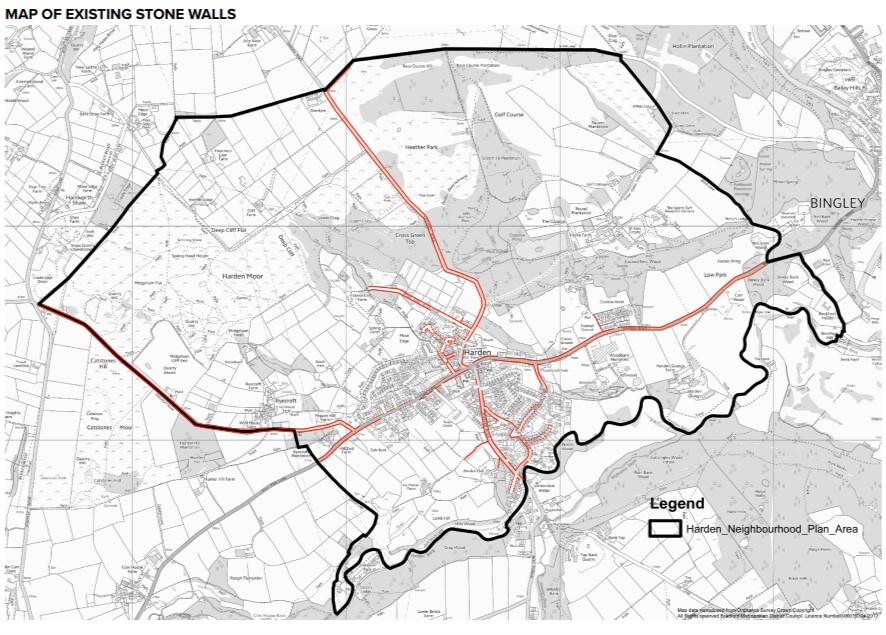
POLICY HNDP20: STONE WALLS
Stone walls, including areas of historic dry-stone wall should be retained and restored using local stone and traditional techniques wherever possible in new developments or in refurbishments.
6.2.8 Dry stone walls are a defining feature of Harden that contributes to the rural character of the village. This policy seeks to ensure that existing stone walls are retained, wherever possible, where planning permission is required.'
6.2.9 For over 300 years quarrying was prominent on the western edge of Harden Moor with many quarrymen residing in the hamlet of Ryecroft. Yeadonian Sandstone quarried here was used to build many local buildings and dry stone walls. Stone was also quarried in Harden to help build Saltaire.
6.2.10 Engagement exercises identified that:
- Dry stones walls are a defining characteristic of Harden that are locally valued
- 43 people felt the plan should include policies that promote heritage and conservation at the initial engagement exercises.
This policy seeks to achieve aims & objectives 3, 4.
This policy aligns with CBMDC adopted core strategy 2017 policy EN3.
MAP 9 – MAP OF EXISTING STONE WALLS
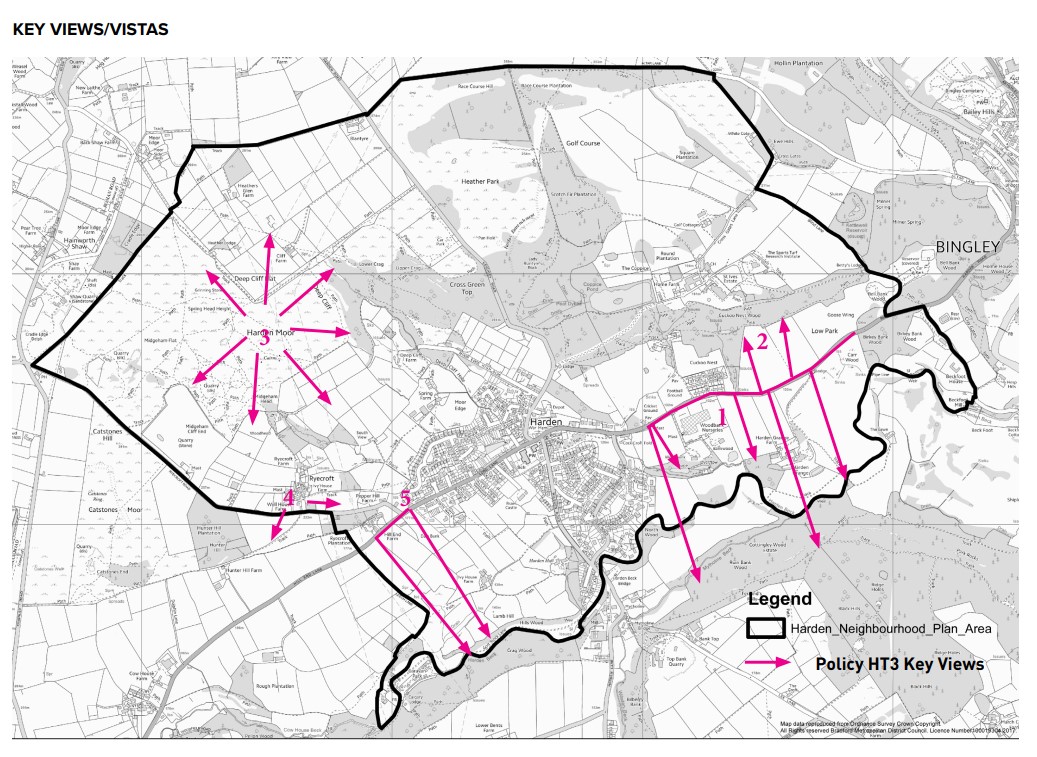
POLICY HNDP21: KEY VIEWS
The views and vistas within Harden village and into Harden village should be retained. Development affecting these views and vistas should be designed in such a way so as not to have a significant adverse impact on their visual quality and amenity. Applications should demonstrate any impact development proposals may have on the views identified below:
- View south from Harden Road
- View north from Harden Road
- Panoramic view from Harden Moor
- Views south from Ryecroft
- View south from Long Lane towards Wilsden
6.2.11 The local topography and landscape provide many great views and vistas of the surrounding area. These are highly valued by residents and visitors and contribute to the rural character of Harden.
6.2.12 The views included in this policy have been suggested by members of the project group. A key view assessment has been undertaken using the Ryecroft Conservation Area appraisal and the Wilsden Landscape Character Supplementary Planning Document, and is contained in the evidence base and appendix to the Neighbourhood Plan. The views included in this policy are non-exhaustive and may be added to or amended in the future.
6.2.13 Initial engagement identified that:
- The rural nature, countryside and green spaces were the 2nd most popular response to what people like to most about Harden.
- Green spaces was the most important issue when people were asked what the Neighbourhood Plan should cover.
This policy seeks to achieve aims & objective 4.
This policy aligns with CBMDC adopted core strategy 2017 policy EN3.
MAP 10 – KEY VIEWS/VISTAS