Harden Neighbourhood Development Plan - Regulation 16 Consultation
9. APPENDIX
9.1 Local Green Space assessments
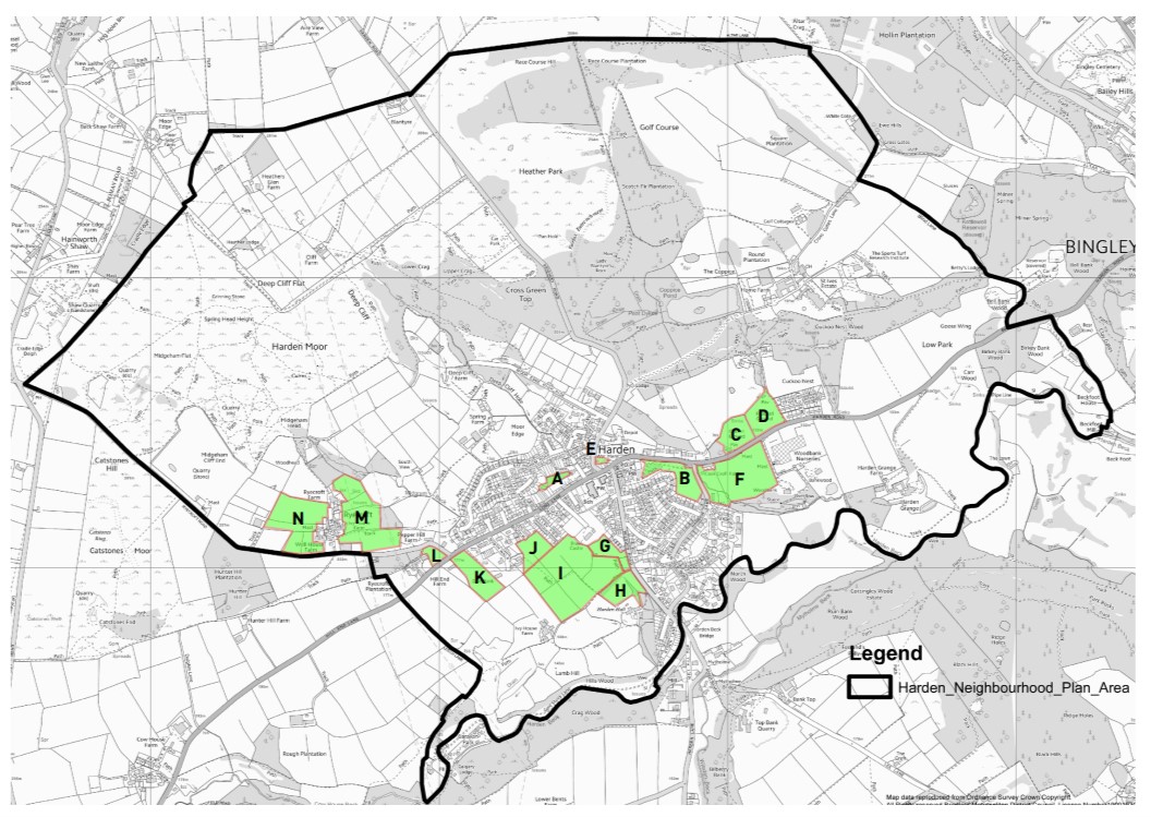
MAP OF ALL GREEN SPACES ASSESSED
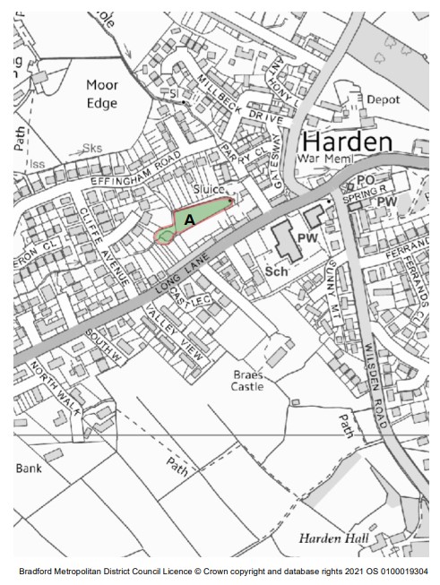
LOCAL GREEN SPACE ASSESSMENT: A
Site name & reference letter: Midgram Beck Millpond (Ref. A)
Location: Beck and millpond north of Long Lane
Size (hectares - ha): 0.1ha
Proximity to community served (ref NPPF 100a): The site is in the village centre and is therefore in close proximity to the community it serves.
Landscape significance, Historic significance, Recreational value, Wildlife richness (ref NPPF 100b): The site is a millpond which forms part of Midgram Beck. Whilst not designated the millpond has some level of landscape significance. The site contributes to wildlife and biodiversity locally.
Local in character / not an extensive tract of land (ref NPPF 100c): The site is local in character and is not an extensive tract of land.
Summary Assessment: The site provides many wildlife and biodiversity benefits despite not being a designated wildlife site. Improved management of the site, perhaps by local volunteers could improve the quality of the site and provide additional benefits to the local wildlife population.
Recommendation: DESIGNATE AS LOCAL GREEN SPACE
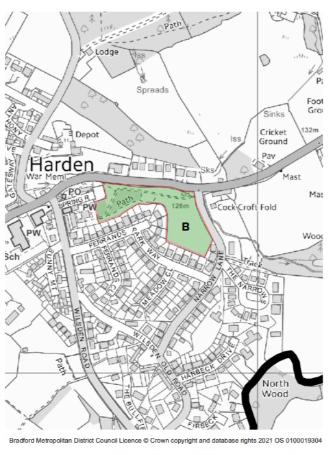
LOCAL GREEN SPACE ASSESSMENT: B
Site name & reference letter: Harden Park (Ref. B)
Location: South of Harden Road, west of Narrow Lane
Size (hectares - ha): 1.5ha
Proximity to community served (ref NPPF 100a): The site is within close proximity to the community it serves. There are residential properties immediately to the south and west of the site.
Landscape significance, Historic significance, Recreational value, Wildlife richness (ref NPPF 100b): The site provides a high level of recreational value. Within the site is a children's playground equipped with play equipment. This is well-used by young people, especially those that use the nearby nursery facilities.
The site is popular with dog walkers, cyclists and is also used for informal sport and leisure activities.
The site is not a designated wildlife site but still contributes to wildlife and biodiversity through its provision of mature trees, hedges and shrubs.
Local in character / not an extensive tract of land (ref NPPF 100c): The site is local in character. The boundary of the park is made from traditional stone. The site is not an extensive tract of land.
Summary Assessment: The site has a high level of recreational value and is popular amongst the local community. The provision of play equipment is well-used and the rest of the site provides informal sports and leisure opportunities.
Recommendation: DESIGNATE AS LOCAL GREEN SPACE
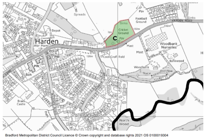
LOCAL GREEN SPACE ASSESSMENT: C
Site name & reference letter: Harden Cricket Ground ref. C
Location: North of Harden Road
Size (hectares - ha): 1.6ha
Proximity to community served (ref NPPF 100a): The site is 450m east of the village centre and has residential properties to the east and west of the site. The site is within close proximity to the community it serves.
Landscape significance, Historic significance, Recreational value, Wildlife richness (ref NPPF 100b): The site has a high level of recreational value and accounts for one of the few sporting facilities within the village. Harden Cricket Club has 6 active teams, including 3 youth teams.
There is an area within the cricket club grounds measuring 0.3ha of mature planting and vegetation. Whilst this is not a designated wildlife site, it is 169m north of the Bradford Wildlife Habitat Network site near Woodbank, and is 230m south of St Ives which is a Local Wildlife Site and within the Bradford
Wildlife Habitat Network. There is potential for this area of the site to contribute to wildlife and biodiversity give it's location and proximity to other sites.
Local in character / not an extensive tract of land (ref NPPF 100c): The site is local in character. It is bounded by traditional stone walls. It is not an extensive tract of land.
Summary Assessment: The site contributes greatly to recreational opportunities locally and therefore has a high level of recreational value. There is also potential for the site to positively contribute to local wildlife and biodiversity. The site is within the Green Belt but it is agreed that given the site's recreational value it is important to specifically designate them as LGS.
Recommendation: DESIGNATE AS LOCAL GREEN SPACE
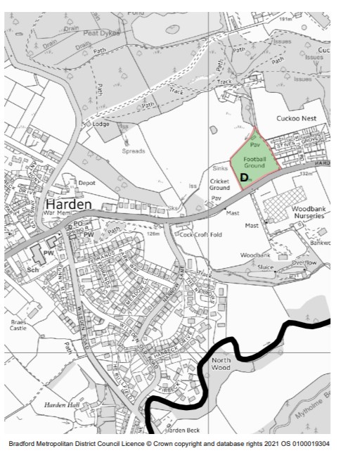
LOCAL GREEN SPACE ASSESSMENT: D
Site name & reference letter: Harden Football Ground (ref D)
Location: North of Harden Road
Size (hectares - ha): 1.1ha
Proximity to community served (ref NPPF 100a): The site is 490m east of the village centre and has residential properties to the east and immediately to the west of the site. The site is within close proximity to the community it serves.
Landscape significance, Historic significance, Recreational value, Wildlife richness (ref NPPF 100b): The site has a high level of recreational value and accounts for one of the few sporting facilities within the village. The ground is well used by Wilsden Juniors AFC.
Local in character / not an extensive tract of land (ref NPPF 100c): The site is local in character. It is bounded by traditional stone walls. It is not an extensive tract of land.
Summary Assessment: The site contributes greatly to recreational opportunities locally and therefore has a high level of recreational value. The site is within the Green Belt but it is agreed that given the site's recreational value it is important to specifically designate them as LGS.
Recommendation: DESIGNATE AS LOCAL GREEN SPACE
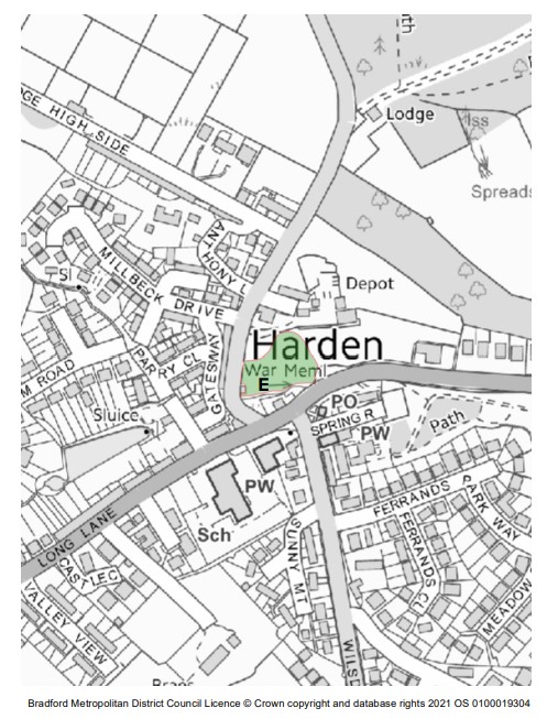
LOCAL GREEN SPACE ASSESSMENT: E
Site name & reference letter: Village Green Space at Highfell Grove (ref E)
Location: Highfell Grove off Keighley Road
Size (hectares - ha): 2.6ha (approx)
Proximity to community served (ref NPPF 100a): The site is in the village centre and is therefore in close proximity to the community it serves.
Landscape significance, Historic significance, Recreational value, Wildlife richness (ref NPPF 100b): It is expected the site will provide recreational opportunities to local residents once complete.
Local in character / not an extensive tract of land (ref NPPF 100c): The site is local in character and is not an extensive tract of land.
Summary Assessment: As indicated in the planning application for the nearby dwellings, the land will be safeguarded as village green space. Because of this it is appropriate to designate the site as local green space.
Recommendation: DESIGNATE AS LOCAL GREEN SPACE
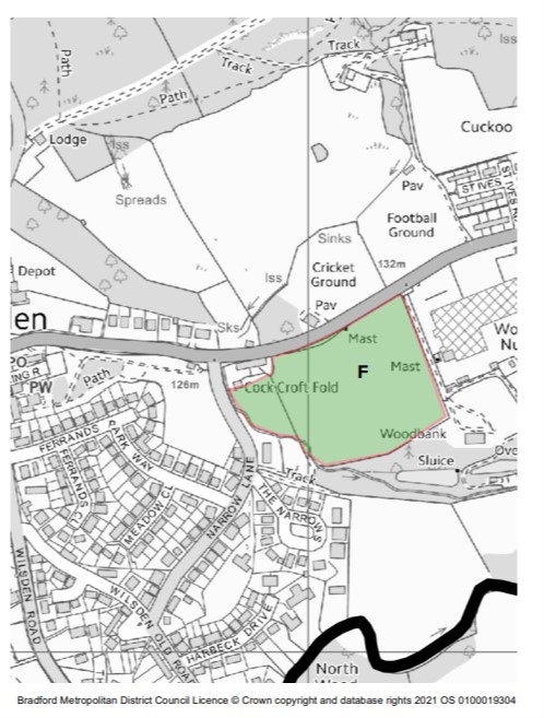
LOCAL GREEN SPACE ASSESSMENT: F
Site name & reference letter: Woodbank (Ref. F)
Location: Land south of Harden Road
Size (hectares - ha): 3.1 ha
Proximity to community served (ref NPPF 100a): The site is east of the village centre and is in close proximity to several residential properties. The site is within close proximity to the community is serves.
Landscape significance, Historic significance, Recreational value, Wildlife richness (ref NPPF 100b): The site bounds Woodbank which is part of the Bradford Wildlife Habitat Network and at its southern edge borders Midgram Beck. Because of its siting next to the BWHN the site possess a richness of wildlife.
To the south east of the site is Woodbank, a grade II listed property so the site also contributes to the setting of a historically significant building.
Local in character / not an extensive tract of land (ref NPPF 100c): The site is local in character and is not an extensive tract of land. The northern site boundary is made of traditional stone walls. The site enables key distant views of the wider landscape and near views of Woodbank (BWHN).
Summary Assessment: The site shares a border with Woodbank which is part of the Bradford Wildlife Habitat Network and therefore contributes greatly to the richness of wildlife in the area. Species spotted on the site include herons, deer, buzzards and grey wagtails The site also contributes to the setting of grade II listed Woodbank and would contribute in the aim of connecting green spaces and wildlife sites within the village to provide greater connectivity and movement for wildlife, however the site is within the green belt and there is no additional benefit in allocating this site as LGS.
Recommendation: DO NOT DESIGNATE AS LOCAL GREEN SPACE
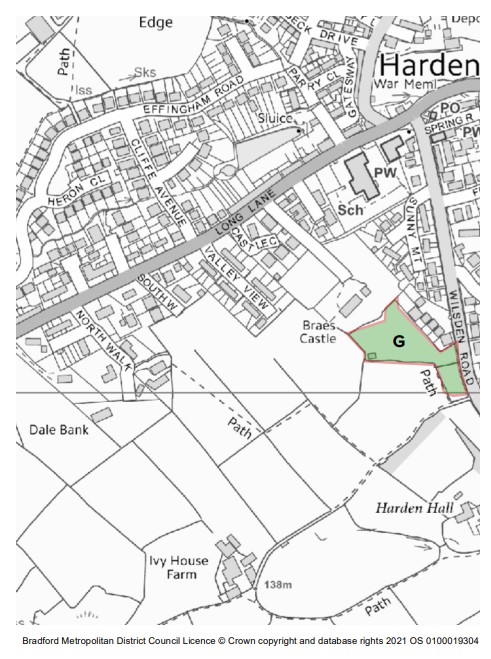
LOCAL GREEN SPACE ASSESSMENT: G
Site name & reference letter: West Wilsden Road (Ref. G)
Location: Land west of Wilsden Road
Size (hectares - ha): 0.6ha
Proximity to community served (ref NPPF 100a): The site is located to the southwest of the village centre and is in close proximity to the community it serves.
Landscape significance, Historic significance, Recreational value, Wildlife richness (ref NPPF 100b): The site provides no recreational value, historic significance or landscape significance. There is no evidence to suggest the site is rich in wildlife.
Local in character / not an extensive tract of land (ref NPPF 100c): The site is local in character and is bounded by traditional stone walls. The site is not an extensive tract of land.
Summary Assessment: The site fails to meet the assessment criteria. The site is within the green belt and there would be no additional benefit in designating this site as a Local Green Space.
Recommendation: DO NOT DESIGNATE AS LOCAL GREEN SPACE
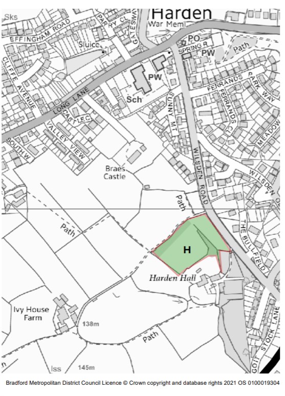
LOCAL GREEN SPACE ASSESSMENT: H
Site name & reference letter: North Harden Hall (Ref. H)
Location: Land north of Harden Hall
Size (hectares - ha): 1.1ha
Proximity to community served (ref NPPF 100a): The site is located to the southwest of the village centre and is in close proximity to the community it serves.
Landscape significance, Historic significance, Recreational value, Wildlife richness (ref NPPF 100b): The site possess recreational value as the site contains a designated footpath that links up with the wider village network supporting walkers and leisure pursuits.
The site is within the green belt.
The site is not a designated wildlife site. There is no evidence to suggest there is a richness of wildlife.
Local in character / not an extensive tract of land (ref NPPF 100c): The site is local in character and is bounded by traditional stone walls. The site is not an extensive tract of land.
Summary Assessment: The site fails to meet the assessment criteria. The site is within the green belt and there would be no additional benefit in designating this site as a Local Green Space.
Recommendation: DO NOT DESIGNATE AS LOCAL GREEN SPACE
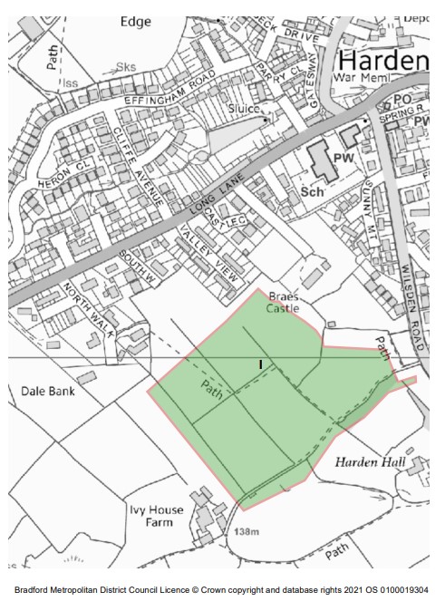
LOCAL GREEN SPACE ASSESSMENT: I
Site name & reference letter: West of Braes Castle (Ref. I)
Location: Land south and west of Braes Castle
Size (hectares - ha): 5.4ha
Proximity to community served (ref NPPF 100a): The site is located to the southwest of the village centre and is in close proximity to the community it serves.
Landscape significance, Historic significance, Recreational value, Wildlife richness (ref NPPF 100b): The site contains a designated footpath which is highly valued by residents as this contributes to leisure and recreational activities locally.
The site is not a Local Wildlife Site nor is it within the Bradford Habitat Wildlife Network. The site is currently in the green belt.
Local in character / not an extensive tract of land (ref NPPF 100c): The site is local in character. At 5.4ha the site is not necessarily an extensive tract of land but is made up of several smaller fields.
Summary Assessment: Despite the presence of a footpath, the site scores poorly against the assessment criteria. Given the site is currently within the green belt, there would be no additional benefit in designating this as a Local Green Space.
Recommendation: DO NOT DESIGNATE AS LOCAL GREEN SPACE
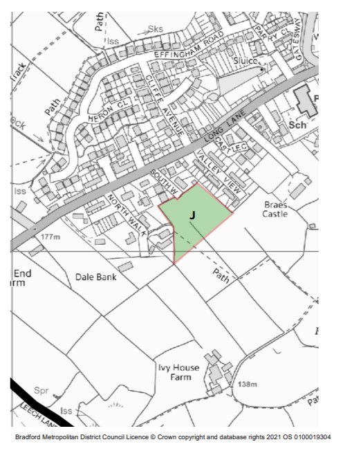
LOCAL GREEN SPACE ASSESSMENT: J
Site name & reference letter: South Walk (Ref. J)
Location: Land south of South Walk
Size (hectares - ha): 0.82ha
Proximity to community served (ref NPPF 100a): The site is located at western edge of the settlement boundary. The site has properties immediately to the north, east and west. The site is in close proximity to the community it serves.
Landscape significance, Historic significance, Recreational value, Wildlife richness (ref NPPF 100b): The site contains a designated footpath which is highly valued by residents as this contributes to leisure and recreational activities locally.
The site is not a Local Wildlife Site nor is it within the Bradford Habitat Wildlife Network.
Local in character / not an extensive tract of land (ref NPPF 100c): The site is local in character is not an extensive tract of land.
Summary Assessment: Despite the presence of a footpath, the site scores poorly against the assessment criteria. The site is one of several sites to be assessed by Bradford Council as a potential housing allocation. This site is also designated as Safeguarded Lane in the RUDP.
Recommendation: DO NOT DESIGNATE AS LOCAL GREEN SPACE
LOCAL GREEN SPACE ASSESSMENT: K
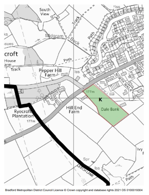
Site name & reference letter: Dale Bank (Ref. K)
Location: Land south of Long Lane, east of Dale Bank
Size (hectares - ha): 1.4ha
Proximity to community served (ref NPPF 100a): The site is located at western edge of the settlement boundary. The site has properties immediately to the east and one property immediately to the west. There are several properties to the northeastern corner of the site. The site is therefore within reasonable proximity to the community.
Landscape significance, Historic significance, Recreational value, Wildlife richness (ref NPPF 100b): The site is within the green belt.
The site is not within the Bradford Wildlife Habitat Network nor it is a Local Wildlife Site. The site has a high level of landscape value and richness of wildlife. Local residents have reported sightings of owls, deer, bats, and phesants. It is also used to graze cattle.
Local in character / not an extensive tract of land (ref NPPF 100c): The site is local in character and is bounded by traditional stone walls. The topography of the site is local in character. The site is not an extensive tract of land.
Summary Assessment: The site is within the green belt and there is no additional benefit in allocating this site as LGS.
Recommendation: DO NOT DESIGNATE AS LOCAL GREEN SPACE
LOCAL GREEN SPACE ASSESSMENT: L
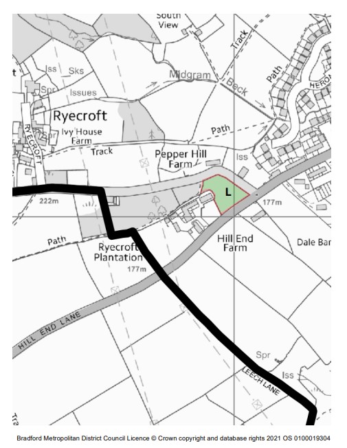
Site name & reference letter: Hill End Lane corner (Ref. L)
Location: Corner of Hill End Lane and Ryecroft Road
Size (hectares - ha): 0.31ha
Proximity to community served (ref NPPF 100a): The site is located at the settlement edge, but is immediately bounded by residential properties on all four sides.
Landscape significance, Historic significance, Recreational value, Wildlife richness (ref NPPF 100b): The site is within the green belt.
To the east of the site on the Ryecroft Road and Hill End Lane junction is grade II listed Hostel Stone and to the west is the grade II listed Hall End Farmhouse. The openness of the site contributes to the setting of these two listed buildings/structures.
Local in character / not an extensive tract of land (ref NPPF 100c): The site is local in character and is bounded by traditional stone walls. The topography of the site is local in character. The site is not an extensive tract of land.
Summary Assessment: The site contributes to the historic setting and maintains the openness around Hall End Farmhouse and the Hostel Stone, however the site is within the green belt and there is no additional benefit in allocating this site as LGS.
Recommendation: DO NOT DESIGNATE AS LOCAL GREEN SPACE
LOCAL GREEN SPACE ASSESSMENT: M
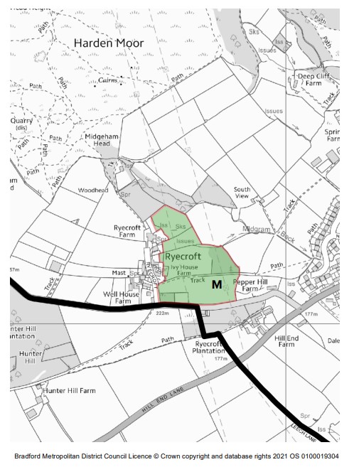
Site name & reference letter: Ryecroft east (Ref M.)
Location: North of Ryecroft Road, east of Ryecroft
Size (hectares - ha): 4.4ha
Proximity to community served (ref NPPF 100a): The site is within Ryecroft which is a small settlement 1km west of Harden village centre. Within Ryecroft is around 15 residential properties.
Landscape significance, Historic significance, Recreational value, Wildlife richness (ref NPPF 100b): The site is historically significant as it forms a key part of the Ryecroft Conservation Area and is listed as a Key Open Space in the Conservation Area Appraisal and as an 'area making a positive contribution to character'. The site contributes to the setting of both listed and key unlisted buildings. The site contains and enables several identified Key Views and Vistas and several important trees.
Local in character / not an extensive tract of land (ref NPPF 100c): The site is local in character as it positively contributes to the defining character of the Ryecroft Conservation Area. The boundary treatments are traditional stone walls.
The site is not an extensive tract of land.
Summary Assessment: The site is historically significant and positively contributes to the character of the area. This is recognised in the Ryecroft Conservation Appraisal which classifies the sites as a Key Open Space and includes Key Views / Vistas and important trees, however there is no additional benefit in allocating this site as LGS. The site is also within the Green Belt.
Recommendation: DO NOT DESIGNATE AS LOCAL GREEN SPACE
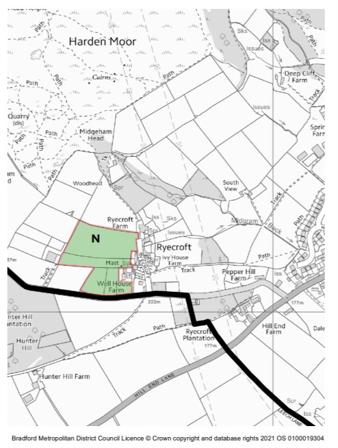
LOCAL GREEN SPACE ASSESSMENT: N
Site name & reference letter: Ryecroft west (Ref N.)
Location: North of Ryecroft Road, west of Ryecroft
Size (hectares - ha): 2.9ha
Proximity to community served (ref NPPF 100a): The site is within Ryecroft which is a small settlement 1km west of Harden village centre. Within Ryecroft is around 15 residential properties.
Landscape significance, Historic significance, Recreational value, Wildlife richness (ref NPPF 100b): The site is historically significant as it forms a key part of the Ryecroft Conservation Area and is listed as a Key Open Space in the Conservation Area Appraisal and as an 'area making a positive contribution to character'. The site contributes to the setting of both listed and key unlisted buildings.
Local in character / not an extensive tract of land (ref NPPF 100c): The site is local in character as it positively contributes to the defining character of the Ryecroft Conservation Area. The boundary treatments are traditional stone walls.
The site is not an extensive tract of land.
Summary Assessment: The site is historically significant and positively contributes to the character of the area. This is recognised in the Ryecroft Conservation Appraisal which classifies the sites as a Key Open Space, however there is no additional benefit in allocating this site as LGS. The site is also within the Green Belt.
Recommendation: DO NOT DESIGNATE AS LOCAL GREEN SPACE