
Wilsden Neighbourhood Plan 2020-2038
ABOUT WILSDEN PARISH
Wilsden is a predominately rural and historic parish situated approximately 6 miles west of Bradford and just south of Bingley.
The population of the Wilsden Parish Council area, which covers the villages of Wilsden and Harecroft and the surrounding farms and houses, was 4,969 based upon mid 2020 ONS data. The Parish Council area contained 2,158 dwellings in November 2022 compared to the 1,819 dwellings in 2004, representing a 18.6% increase.
Wilsden dates back to Saxon times, flourishing in the nineteenth century when the presence of coal, water and wool transformed an agricultural area into an industrial landscape based on textiles. Wilsden initially grew as a farming community, looking very different from its present shape. Housing was not focused along a closely built-up main road but consisted of separate clusters of farms in seven separate hamlets. Some farmers diversified very early into home-based aspects of the textile business, the more prosperous ones converting barns into warehouses and eventually building mills.
Local supplies of building stone and coal were factors in Wilsden's industrial development. The population grew rapidly from 913 at the 1801 census to peak at 3,454 in 1851. This led to the surge of house building, which gave the Village its still recognisable shape and character. Numbers then declined, only exceeding the 1851 figure in the second half of the twentieth century.
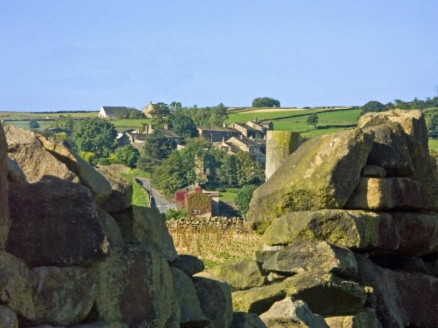
View towards Wilsden Hill
The Parish still retains many buildings from this period and the historic core of Wilsden was made a Conservation Area in 1977. Whilst some of the original hamlets have been absorbed within the settlement boundaries, others have retained their separate characteristics.
With the decline of the textile industry, most of the working population is employed outside the parish, predominantly in Leeds and Bradford. Although for many Wilsden is a dormitory village, there are many small and medium size enterprises in the area. The number of people working in the area is over one third of the total working age population, although a significant number of these commute into the parish. The number of people aged over 65 in in the area is 25.8% of the population compared to 15.2% for the whole district. The proportion of the population of the Bradford district that is under 15 is 25.3% whereas in Wilsden the proportion under 15 is 15.6%. This means that Wilsden has a different demographic to the district as a whole.
Fortunately, the shape of the valley, with a degree of vigilance, has ensured the survival of the character of this independent community, even after a second wave of growth.
Wilsden is on a north facing slope with its lowest point above sea level being 115 m (375 ft.) at the boundary with Harden and the highest point being 285 m (937 ft.) at the boundary with Thornton.
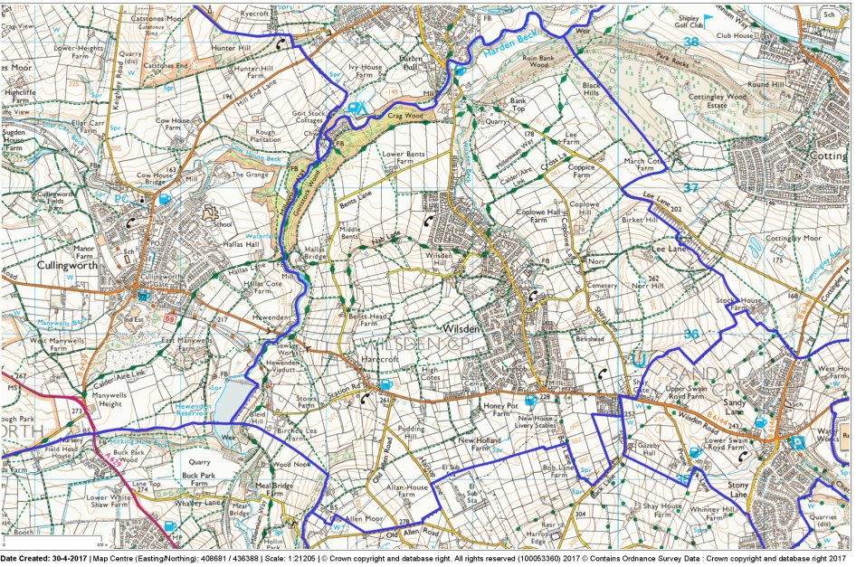
Figure 1 Wilsden Neighbourhood Plan Area