
Wilsden Neighbourhood Plan 2020-2038
1 A SUSTAINABLE WILSDEN PARISH
1.1 A Presumption in favour of Sustainable Development
1.1 The objective of the UK Planning System, as set out in the NPPF, is to achieve sustainable development. Resolution 42/187 of the United Nations General Assembly defined sustainable development as "ensuring that better lives for ourselves does not mean worse lives for future generations".
1.2 This Neighbourhood Plan has the purpose of securing sustainable development at its heart. This includes how much new development is required to meet the needs of the local community, where it should best go and how it should be designed, both for now and in the future. This encompasses all proposals for development from the very smallest, such as a minor extension to a house, to major housing and employment developments.
1.3 In January 2021 Wilsden Parish Council declared a Climate Emergency. In order that the environmental impact of all new housing is minimised Design Codes have been developed that include recommendations on sustainability and climate change.
1.4 The Parish Council will take a positive approach to the consideration of development proposals that contribute to sustainable development. This includes working with CBMDC, the local community, developers and other partners to encourage the formulation of development proposals, which clearly demonstrate how sustainable development has been considered and addressed and can be approved without delay.
1.2 Directing Development to the most Sustainable Locations
1.2.1 One of the key ways in which the planning system can ensure sustainability is to direct development to the most appropriate locations.
1.2.2 The Core Strategy for CBMDC establishes a hierarchy of settlements of the Regional City of Bradford, the principal towns of Keighley, Bingley and Ilkley, local growth centres and local service centres and rural areas. Wilsden has been identified as a Local Service Centre where "the emphasis will be on a smaller scale of development …. together with the protection and enhancement of those centres as attractive and vibrant places and communities, providing quality of place and excellent environmental, economic and social conditions".
1.2.3 The Core Strategy also adds that by the end of 2030 the Pennine Villages of Oakworth, Oxenhope, Harden, Wilsden, Cullingworth and Denholme will "have retained their individual characters and sense of place whilst seeing a smaller scale of housing development and the provision of amenities served by improved bus and rail links to Keighley town centre, Bradford city centre, Bingley, Queensbury and neighbouring Halifax". The community generally supports the role for Wilsden as indicated in the hierarchy of settlements set out in the Core Strategy.
1.2.4 There is overwhelming community support for the use of previously developed land in preference to greenfield development. In seeking to maximise the use of previously developed land, the Core Strategy; Policy HO6 sets a target of 35% of development in local service centres such as Wilsden to be on previously developed land. This target has been reduced to 30% of development on previously developed land in the emerging Local Plan. This Plan supports the effective, efficient and sustainable use of land. To be supported, priority should be given to the use of previously developed (brownfield) land over greenfield sites. Development in the Green Belt will only be supported if it comprises appropriate development in the Green Belt in accordance with national and BMDC Green Belt policy'. This Plan actively encourages development to meet Wilsden's housing needs to be located within the Settlement Boundary of Wilsden, as shown in Figure 2.
1.2.5 In order to achieve the levels of development identified for the Parish in the Core Strategy and in the most sustainable way, this Plan advocates a focus on carefully controlled and limited smaller scale housing and other forms of development within the established built-up area boundary of the Village of Wilsden. This approach reflects the views of the local community.
1.2.6 The consultation carried out during the development of this Plan established that residents recognise the need for limited development in the Parish to accommodate growth, meet housing and other development needs and help sustain local services and facilities. Equally the consultation showed that residents wish to ensure that development will not dominate or have an adverse impact on the distinctive character of the Parish. Concern was also expressed that developments should not place undue pressure on local services and facilities.
1.2.7 The consultation showed that the community wishes to see a smaller more compact pattern of development especially in Wilsden village, reducing the need to travel to access local services and minimising development on green field sites. In the survey of residents 64% (93) of respondents agreed that new housing should be built densely so as to protect green field land. This approach is also consistent with the Core Strategy and national planning policies which seek to focus development in the established built-up areas and avoid development in the open countryside.
1.2.8 A key element of this approach is the scale of development, especially housing, with an emphasis on smaller more compact housing sites. It is considered that this type of development is most suitable for the Parish as it would best complement the existing scale, character and pattern of development, minimise the risk of urban sprawl and effectively promote more sustainable forms of development. This approach recognises in principle that the density of development, especially for housing, may need to be higher to accommodate the growth planned. Policies W/HO/2 and W/HO4 give more detail as to how this Plan proposes to achieve this.
1.2.9 In the smaller villages and hamlets in the Parish a lower level of development will be supported in principle where it is small scale, appropriately designed and located and meets a local need. Furthermore, because the area of the Parish outside of the built-up part of Wilsden is 'washed over' by the Green Belt, its contribution to meeting identified development needs will be limited to those types of development which are appropriate in the Green Belt.
1.3 Wilsden Village Settlement Boundary
1.3.1 A Settlement Boundary is a commonly used tool in planning documents such as neighbourhood plans and local plans/core strategies. It is used to define the extent of a built-up part of a community. It distinguishes between areas where in planning terms development would be acceptable in principle, such as in a town or village, and where it would not be (generally in the least sustainable locations) such as in the open countryside. The current Settlement Boundary was established in the Bradford Replacement Unitary Development Plan (RUDP), adopted in May 2005.
1.3.2 For the purposes of the neighbourhood plan, the settlement boundary is that part of the village that is not in the Green Belt. The designation of the Settlement Boundary will focus the modest scale of development envisaged for the Parish towards Wilsden village and generally supports the smaller more compact pattern of development which the Plan proposes. This will reinforce Wilsden's role as the local centre and hub for the surrounding area and the wider Parish. In addition, it will help protect the distinctive and beautiful countryside of the Parish, which is protected by Green Belt status and has been identified of being of special landscape value.
1.3.3 The consultation shows that the community also shares the view that Wilsden Village is generally a more appropriate and sustainable location for development than the rest of the Parish. This is a view echoed in the Core Strategy.
1.3.4 The existing Settlement Boundary, as shown in Fig 2, is considered to reflect an appropriate and sustainable settlement boundary. It is however recognised that the proposed housing allocation of at least 200 dwellings as set out in the CBMDC Core Strategy may not be achieved without some changes to the Green Belt boundaries. Within the Settlement Boundary for Wilsden small scale, sustainable development will be viewed sympathetically.
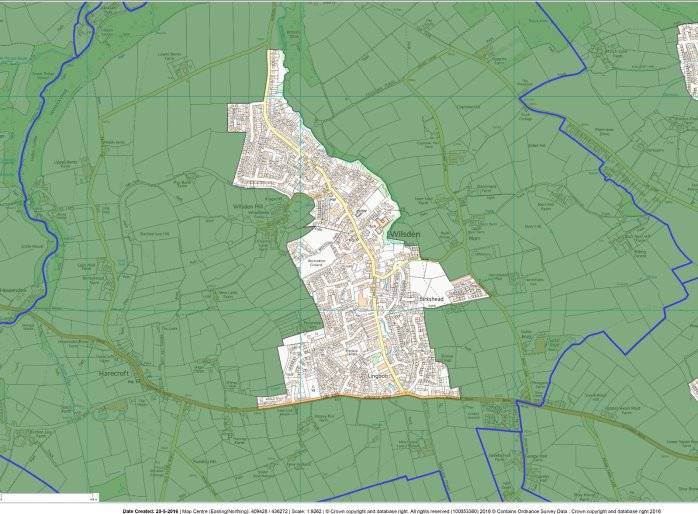
Figure 2 Wilsden Village Settlement Boundary
POLICY W/HO1 - DEVELOPMENT WITHIN WILSDEN VILLAGE
Within the Settlement Boundary for Wilsden, as shown on the Figure 2 and defined as land not in the Green Belt, development proposals will be supported where it can demonstrate that it has taken into account the following, that:
- It respects the size, character and level of service provision of Wilsden;
- It retains existing natural boundaries and features such as trees, hedges, streams and walls (especially dry stone) which either contribute to visual amenity or are important for their ecological value, wherever possible and appropriate;
- It respects and, where possible, enhances the distinctive qualities of the special and attractive landscape in which Wilsden is situated;
- It protects the heritage value and enhances the setting of any locally or nationally designated asset of heritage value, where a proposal would affect the setting of that heritage asset;
- It conserves and, where possible, enhances Wilsden Conservation Area and its setting, where relevant;
- It does not reduce garden/green space to an extent where it adversely affects the distinctive character of Wilsden or the amenity of the proposed occupiers of the new development or adjacent properties/uses;
- It considers the impact on neighbouring occupiers' use by way of excessive overlooking, overshadowing, over-dominance and loss of outlook; and
- Safe and suitable access to the site can be achieved.
- It supports sustainable travel options of walking, cycling and public transport.
In addition to the above Policies W/HO4, W/BH1, W/BH2, W/BH4, W/NE2, W/NE3 and W/NE4 contain detailed policies on specific areas.
1.4 Review of the Green Belt
1.4.1 The majority of Wilsden is designated as Green Belt. It covers much of the open countryside in the Parish, including large swathes of land. The general extent of the Green Belt in the Parish is shown at Figure 2. There is strong community sentiment regarding the Green Belt that generally surrounds the built-up part of Wilsden village. It not only helped retain the distinct character of the area and helps focus development in more sustainable locations, but also provides opportunities for recreation and leisure and contains many key 'Green Infrastructure' assets including sites of nature conservation value.
1.4.2 National Planning policy is clear in its support for the Green Belt, emphasising its essential characteristics of openness and permanence. It also states that inappropriate development (such as the construction of new buildings) which is harmful to the role and function of the Green Belt should not be approved except in very special circumstances.
1.4.3 As the NPPF states in paragraph 137 'The government attaches great importance to Green Belts. The fundamental aim of Green Belt policy is to prevent urban sprawl by keeping land permanently open; the essential characteristics of Green Belts are their openness and their permanence'. The NPPF in paragraph 138 states that Green Belt serves 5 purposes.
- to check unrestricted sprawl of large built-up areas
- to prevent neighbouring towns from merging
- to safeguard the countryside from encroachment
- to preserve the setting and special character of historic towns
- to assist in urban regeneration, by encouraging the recycling of derelict and other urban land
1.4.4 The NPPF also states that changes to the Green Belt can only be made in exceptional circumstances (paragraph 140) and the need for such changes is a strategic decision for the local planning authority. Although the need for such changes to the green belt is a strategic matter the NPPF makes clear that a neighbourhood plan can have a view on how and where those changes take place.
1.4.5 The neighbourhood planning process has highlighted the value and importance that the community place on the Green Belt surrounding Wilsden village and the contribution it makes to local distinctiveness, character and quality of life. Its protection is a top priority for the community.
1.4.6 The CBMDC Core Strategy identifies that some changes to the adopted Green Belt around Wilsden may be required in order for the village to meet the allocated housing number. CBMDC is currently in the process of preparing a new Local Plan and although the housing numbers allocated to Wilsden and the time period over which they are delivered are different some Green Belt changes may be required over the plan period. This will ensure that the preparation of the Local Plan is used as the mechanism for the detailed identification of the Bradford Green Belt boundaries in accordance with national planning policy. It will also provide the proper opportunity for residents, developers and other interested bodies to contribute to this debate both in general terms on the Green Belt boundary and to provide the agreed levels of development for the District.
1.4.7 The methodology used to review the Green Belt is defined by CBMDC and is consistent across the whole district. Before considering the issue of land availability the process involved assessing parcels of land against the five main purposes of the Green Belt. Not all land in the district was considered for potential changes to the Green Belt boundary. Parcels with an inner boundary more than 50 metres from the existing boundary were excluded from any changes.
1.4.8 An important factor when considering changes to the existing settlement boundary is whether this results in a village with strong defensible boundaries. Wilsden has two strong and defensible boundaries that must be taken into account when considering possible changes.
- The B6144 Haworth Road from the PC boundary with Sandy Lane to Harecroft is a strong southerly boundary to Wilsden.
- The wooded valley of Wilsden Beck from Bank Bottom to Crack Lane is a strong north-easterly boundary to Wilsden. Access to the village across this wooded valley is extremely limited.
1.4.9 In addition to maintaining strong defensible boundaries, it is also necessary to guard against merging with neighbouring communities. This assessment of all the parcels of land was then correlated with sites that had been put forward for development. A further factor to consider is the potential housing yield in relation to the allocated housing numbers for Wilsden. Based upon the available data we would acknowledge changes to the Green Belt boundary may be required such as the sites designated WI2/H and WI3/H (as shown in Figure 3) recommended in the Draft Local Plan are included within a revised Wilsden Settlement Boundary.
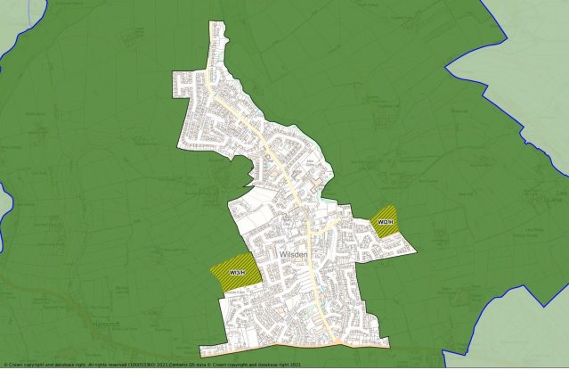
Figure 3 Wilsden Village Settlement Boundary with possible options for change
1.5 Development outside Wilsden Village
1.5.1 In planning terms, land outside a defined Settlement Boundary, including any small groups of buildings or small settlements that may be found there, is treated as countryside. There is strong support for this land to continue as countryside. Since its beginnings, Wilsden has been, and largely remains, a rural parish. Outside the village the land remains overwhelming in open use such as farming. The overall appearance of the countryside remains much as it would have been 100 years ago, despite a degree of modern development.
1.5.2 This countryside is one of the Parish's most valued characteristics, as underlined by the findings of the consultation. Residents wish to see this open countryside protected and, wherever possible, enhanced to remain an attractive, accessible and non-renewable natural resource. Residents want to avoid less sustainable forms of development and prevent urban sprawl resulting in the coalescence of the distinct settlements that comprise Wilsden Parish into nearby villages and settlements. This strong local wish to support and protect the distinctive character of the landscape and countryside also accords with district-wide and national policy.
1.5.3 In particular, the countryside in Wilsden Parish is designated as Green Belt. The main purpose of this designation is to protect the land around towns and cities from urban sprawl by keeping land permanently open. Within the Green Belt there are strict planning controls over the type of development, which can take place within it. The NPPF (paragraphs 147 to 151) detail the special circumstances that can result in development being permitted in the Green Belt.
1.5.4 Furthermore, much of this countryside has also been identified as having a special and attractive landscape, not only in terms of its beauty, but also the species and habitats it supports. Natural England has divided England into 159 distinct natural areas. Each is defined by a unique combination of landscape, biodiversity, geodiversity, history, and cultural and economic activity. The Parish forms part of the Yorkshire Southern Pennines Fringe Landscape, of which" the most striking aspect of the landscape is the mingling of predominantly 'gritstone' industrial towns and villages with the strong valley forms and pastoral agriculture of the Pennine foothills.
POLICY W/HO2 DEVELOPMENT OUTSIDE WILSDEN SETTLEMENT BOUNDARY - THE GREEN BELT
The Plan supports the continued designation of the open countryside outside of Wilsden village as Green Belt. Within the Green Belt, there will be a strong presumption against development that would conflict with the purposes of the Green Belt or adversely affects its open character.