
Wilsden Neighbourhood Plan 2020-2038
4 NATURAL ENVIRONMENT
4.0.1 Wilsden Parish is mainly rural and open in character. Much of it is countryside and its landscape is characterised by attractive, gently rolling hills, predominantly grazing pastureland, interspersed with tracts of wooded areas. The Village of Wilsden is the only large settlement, but there are separate smaller hamlets of Harecroft, Norr, Hallas Bridge and Shay Gate plus farms and small groups of cottages. The countryside around the main settlements is notable for a historic network of narrow winding lanes, footpaths and packhorse trails. The dry-stone wall field boundaries are an important characteristic of the area.
4.0.2 This rural and open character of the Parish is defined not only by the countryside, but also by the open spaces within Wilsden Village and the other hamlets across the Parish. Evidence shows that the rural and open nature of the Parish is important and cherished by the community, not only for the important contribution it makes to its attractive and distinctive character, but also for the wider contribution it makes to well-being. For example, it provides opportunity for exercise, sport and active recreation as well as protecting and enhancing the natural environment including its wildlife and wildflowers.
4.1 Important Local Green Spaces
4.1.1 Wilsden Parish has a diverse mix of local green spaces such as parks, recreation areas, grassed areas and children's playgrounds that mainly exist around, within and between the main settlements. Individually and collectively these areas make a significant contribution to the distinctive and attractive character of the Parish, and deserve protection for the benefit of the residents, as well as its wildlife.
4.1.2 The National Planning Policy enables a Neighbourhood Plan to identify for special protection green areas of local importance. In addition, Policy EN1 of the Core Strategy of the CBMDC Local Plan states that, "The Council will work with local communities to identify areas of Local Green Space in the local plan and neighbourhood plans. Local greenspace which is valued for amenity, recreation and wildlife or contributes towards character, distinctiveness and visual quality will be protected from development, other than in very special circumstances which are supported by the local community."
4.1.3 To be designated as Local Green Space, however, it must meet specified criteria as set out in the National Planning Policy Framework. These are:
- where the green space is in reasonably close proximity to the community it serves;
- where the green area is demonstrably special to a local community and holds a particular local significance, for example because of its beauty, historic significance, recreational value (including as a playing field), tranquility or richness of its wildlife; and
- where the green space concerned is local in character and is not an extensive tract of land.
4.1.4 The many green spaces in the Parish were evaluated for their suitability for Local Green Space designation through the Plan. After careful consideration, seven green spaces have been identified that are considered to have the greatest importance and meet the criteria for designation. More details of the evidence to support the identification of these sites along their detailed boundaries are given in a document detailing Supporting evidence on Local Green Spaces as a part of this Plan. The specific sites are detailed in Table 1 and shown in Figure 8
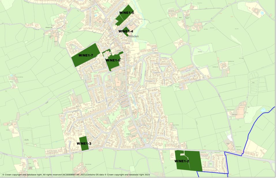
Figure 8 Important Local Green Spaces
.
Table 1 – Local Green Spaces
|
Area (ha) |
||
|
W/NE1-1 |
Fields to the East /Northeast of St Matthews Church |
0.244 |
|
W/NE1-2 |
Cricket Pitch and adjacent field (formerly football field). |
2.239 |
|
W/NE1-3 |
Closed graveyard, old St Matthew's churchyard. |
0.459 |
|
W/NE1-4 |
Wilsden Primary School field. |
0.178 |
|
W/NE1-5 |
Wilsden Allotments |
0.518 |
|
W/NE1-6 |
Royd House Park and Play Area |
0.817 |
|
W/NE1-7 |
Wilsden Recreation ground |
1.486 |
POLICY W/NE1 IMPORTANT LOCAL GREEN SPACES
The sites listed below and shown on the Policies Map (and Figure 8) are designated as Local Green Spaces.
W/NE1-1 Fields to the East /Northeast of St Matthews Church
W/NE1-2 Cricket Pitch and adjacent field (formerly football field)
W/NE1-3 Closed graveyard, old St Matthew's churchyard
W/NE1-4 Wilsden Primary School field
W/NE1-5 Wilsden Allotments
W/NE1-6 Royd House Park and Play Area
W/NE1-7 Wilsden Recreation ground
Development will only be supported in very special circumstances as set out in the NPPF para 103 and will be consistent with the exceptional circumstances that allow development in the Green Belt.
4.2 Ecology and Biodiversity
4.2.1 Biodiversity includes all kinds of animal and plant species, from the commonplace to the critically endangered as well as the habitats which support them. The 2021 Environment Act introduces a mandatory requirement for Biodiversity Net Gain in the planning system, to ensure that new developments enhance biodiversity and create new green spaces for local communities to enjoy.
4.2.2 Wilsden is rich in ecology and biodiversity. This is due to the different type of habitat that can be found in the Parish such as upland pasture and woodlands as well as the variety of wildlife and wildflowers these areas support, including rare and declining species such as the curlew. Nationally important ecological and bio-diversity sites are protected by law, notably through their designation as a Sites of Special Scientific Interest.
4.2.3 Whilst there are no sites of national importance, there are a number of sites and habitats that are of local and regional importance. These sites include a number of designated Local Wildlife Sites and the Bradford Wildlife Habitat Network. These sites are illustrated in Figure 9 which has been prepared in conjunction with the West Yorkshire Ecology Service.
4.2.4 There are two Local Wildlife Site within theBradford Wildlife Habitat Network that are partially within the Neighbourhood Plan area;
- Goitstock Wood and Grassland.
- Cottingley Woods – Black Hills
4.2.5 The Bradford Ornithological Society reports that the bird life of Goitstock Wood includes the presence of Wood Warblers and Spotted Flycatchers. Dippers are present along the river, and Grey Wagtail usually breed there; Kingfishers also inhabit the river.
4.2.6 In addition to the Bradford Wildlife Habitat Network the emerging CBMDC Local Plan in Policy EN2 establishes the category of Local Wildlife Habitat Networks. This Plan establishes a number of Wilsden Wildlife Habitats that have been identified by the local community in partnership with West Yorkshire Ecology Service. These sites are shown in Figure 9.
4.2.7 Wilsden Parish Council owns and/or controls two woodland sites that are managed with the objective of enhancing the biodiversity. The two sites are;
- Bilberry Bank
- Closed churchyard on Laneside.
POLICY W/NE2 ECOLOGY AND BIODIVERSITY
The biodiversity of Wilsden, including local and nationally important sites as Identified in Figure 9, should be protected and enhanced. Wilsden Parish Council is committed to conserve and enhance biodiversity in the area with particular emphasis local Wildlife sites at Goitstock Woods and Cottingley Woods – Black Hills along with sites it owns or controls, in particular Bilberry Banks and the closed churchyard on Laneside. All development proposals should deliver biodiversity net gain and if this cannot be delivered on-site it should be directed towards the above areas.
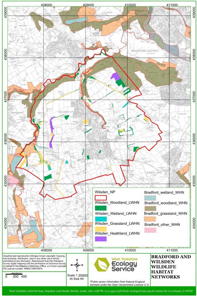
Figure 9 Bradford & Wilsden Wildlife Habitat Networks
4.3 Trees
4.3.1 Trees form an important part of Wilsden's distinctive and attractive character and landscape and are important for their amenity value. There are a significant number of trees and areas of woodlands scattered across the Parish including some mature specimens. Some of the areas have remained as woodland for many hundreds of years. Figure 8 shows important local and district wide Woodland Wildlife areas.
4.3.2 The wooded valleys of both Wilsden and Harden Beck are an important feature of the landscape character and in maintaining the ecology and biodiversity of the area. While some individual specimens are protected through a Tree Preservation Order and other national designations, many are not specifically protected. Consultation shows that trees are important to the local community and that tree coverage in the Parish should be protected and, wherever possible, increased.
4.3.3 CMBDC Core Strategy policy 'EN5: Trees and Woodlands' seeks to protect and enhance all trees and woodlands that are important to the character of the district. This is something that the Plan strongly supports. It is important that future planting is sympathetic to the local landscape character in terms of scale, species type and contributing to biodiversity.
POLICY W/NE3 TREES
The Plan supports the planting and management of trees. The trees to be planted should be matched to site and climatic conditions with a preference towards native and productive species. Any tree planting should take account of the value of existing habitats when identifying suitable locations. The habitat network includes areas of grassland and heathland and wetland which should be preserved and enhanced and would not be suitable for tree planting. Trees and hedgerows of good arboricultural, biodiversity and amenity value should be protected from loss or damage as a result of development.
4.4 Landscape
4.4.1 Wilsden has a distinctive and attractive landscape that provides a rural setting for the Parish and helps to define its unique character and attractiveness. In 2008 CBMDC adopted a series of Landscape Character studies as a part of the development of the Local Plan. The designated area of this neighbourhood plan is covered by two volumes, Volume 9 Wilsden and Volume 6 Thornton.
4.4.2 This identified the special nature of the landscape in Wilsden. This described it as being "characterised by a gently rolling, open elongated bowl-shaped valley sloping in a north easterly direction towards the Aire Valley". It also highlighted the following landscape features as being especially important to the Parish and the wider area:
- Rolling, concave plateau landform.
- Improved grasslands extensively farmed and managed.
- Strong field pattern with stone wall boundaries.
- Significant woodland cover including mixed plantations.
- The principal settlement of Wilsden and the hamlets of Harecroft and Hallas Bridge.
4.4.3 This Study also highlighted the strength and importance of this landscape, its sensitivity to change and development, and that development would require careful siting. The findings of the Study have been reinforced by other reports and studies. Natural England has divided England into 159 distinct natural areas. Each is defined by a unique combination of landscape, biodiversity, geodiversity, history, and cultural and economic activity. The Parish forms part of the Yorkshire Southern Pennines Fringe Landscape, of which" the most striking aspect of the landscape is the mingling of predominantly 'gritstone' industrial towns and villages with the strong valley forms and pastoral agriculture of the Pennine foothills.
4.4.4 It is important, therefore, that any development contributes positively to the Wilsden landscape and ensures that its distinctive character and quality is retained and that it is sympathetic to landscape setting and landform.
4.5 Important Views and Vistas
4.5.1 During the development of the Wilsden Neighbourhood Plan the Steering Group undertook a number of community consultations through both meetings and drop-in sessions and through a questionnaire that was delivered to every household. Through these events it is clear that the panoramic views of the countryside around Wilsden were important to residents. The results of these consultations established that while there were a number of points where residents had favourite views and vistas there were five locations which commanded the panoramic views that were most valued. These locations are described below and illustrated on a map in Figure 10.
- The panoramic view from Wilsden Recreation Ground looking east and north that encapsulates the character of the Wilsden area, showing the wooded valleys running up to the Wilsden, Harden and Cullingworth.
- The view southwest from Harecroft towards the Hewenden Viaduct of the wooded incline leading into the wooded valley, which runs across the mixed upland pasture.
- The view northeast from Hewenden Viaduct towards Harecroft shows the quarries where the stone was taken to build the viaduct in the foreground. This illustrates how the settlement merges into the mixed upland pasture and the patchwork of stone walls.
- The views from Wilsden Hill looking north and east show how the settlements are separated by the mixed upland pasture. The view north illustrates the separation between Harden and Wilsden and the dominance of the field pattern in the landscape, where the patchwork of stone walls stands out on the gently sloping terrain. The view east shows the village in the foreground with a mix of more modern housing blending with the core of the Victorian mill village
- The views from Norr Hill looking north and west show the settlement of the Norr in the foreground with the main village nestling in the valley bottom and the settlement of Wilsden Hill in the middle distance. Beyond Wilsden Hill there are views of Cullingworth and the far distance Haworth Moor.
4.5.2 Detailed evidence to support the important views and vistas is given a separate supporting document to this Plan. Any development proposal shall take these views and vistas into account and ensure that they are respected and enhanced.
POLICY W/NE5 IMPORTANT OPEN VIEWS AND VISTAS
Development proposals should seek to maintain, respect and, wherever possible, enhance the following identified important views and vistas within the neighbourhood area and shown on the Policies Map (as well as Figure 10).
W/NE5-1: View from Wilsden Recreation Ground
W/NE5-2: View westward from Harecroft
W/NE5-3: View eastward from Hewden Viaduct
W/NE5-4: View from Wilsden Hill
W/NE5-5: View from Norr
Proposals should ensure that the visual impacts of development on these views is carefully and sympathetically controlled, in terms of scale, nature, massing and layout. Where appropriate, applicants will be expected demonstrate how their proposals take account of any impacts on these views and vistas.
4.6 Areas of Local Separation
4.6.1 It is important to ensure that individual and historic settlements that make up the Parish retain their own character and identity. Public consultation during the development of this Plan showed that this is a top priority for local people. Three particular areas of separation were identified as being of high priority to residents.
- Land between Wilsden and Sandy Lane/Allerton.
- Land between Wilsden and Harden.
- Land within Wilsden between the settlements of Norr and Wilsden Hill.
4.6.2 Existing CBMDC Green Belt planning policies as well as policies contained in this Plan, notably W/HO4, will perform an important role in maintaining the physical separation of these settlements. As the Wilsden Landscape Character SPD states "There is a real danger of the villages joining up through development, particularly Harden and Wilsden. Further development along routes through the countryside would cause fragmentation of this unit of landscape by creating urbanised traffic corridors of developed land bearing little relation to the particular character of the individual villages."
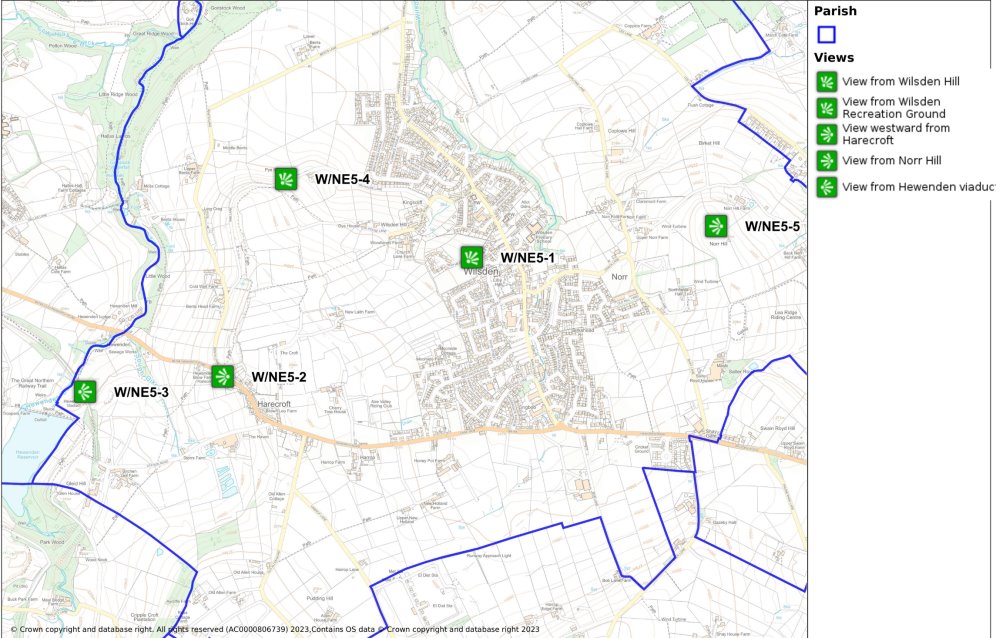
Figure 10 Important Views and Vistas