
Wilsden Neighbourhood Plan 2020-2038
3 BUILT HERITAGE
3.0.1 Wilsden has a very distinctive and attractive built environment which gives it a great sense of place and pride. It contains many fine buildings, some of which have been recognised nationally as being of special historic and architectural importance, which reflect the incremental development of the Parish over many hundreds of years. They embrace farm buildings from the late seventeenth century, as well as mills and cottages dating from the early and late nineteenth century, many linked to textile manufacturing. These buildings are clustered in the historic core of Wilsden, and around former farm buildings and mills.
3.0.2 Consultation shows conserving and enhancing this distinctive built environment is a top priority for residents and visitors, and that new development should acknowledge its character and environment. In Figure 5 below we show all Wilsden Heritage Assets. Wilsden Conservation Area is shaded green.
3.1 Nationally Important Buildings, Sites and Structures
3.1.1 There are over 20 'Listed Buildings' and one Scheduled Monument within the Parish that have been identified as being of national significance and importance. These include a wide variety of buildings and structures, including former 19th Century Mill Cottages (such as Chapel Row and Club Row); former farmhouses which predate the Industrial Revolution (e.g. Lee Farmhouse) and buildings associated with Wilsden's heritage (e.g. Bents Mill). It also includes structures such as dry-stone walls (e.g. the Walls flanking footpaths to Wilsden Hill) and other buildings (e.g. Hewenden Viaduct). The full schedule of Listed Buildings and Structures in the Parish is shown in Appendix 1.
3.1.2 The designation of these buildings and structures as Listed Buildings gives them special legal protection beyond that which can be provided through a Neighbourhood Plan. It is important, however, that the Plan highlights them, especially to ensure that all interested parties are aware of their local importance, and the need to conserve and enhance this.
3.2 Wilsden Non-Designated Heritage Assets
3.2.1 In addition to the nationally recognised buildings and structures, a number of heritage assets have been identified as part of the consultation that have an important and positive contribution to the identity and distinctive character of the Parish and are valued by the local community.
3.2.2 National and local planning policy enables such locally important buildings and structures to have formal recognition in the planning system. CBMDC Policy EN3 of the Core Strategy states that "The Council, through planning and development decisions, will work with partners to proactively preserve, protect and enhance … the heritage significance and setting of locally identified non-designated heritage assets".
3.2.3 Through detailed consultation and analysis, buildings and structures have been identified as especially important to the character of the Parish; the Plan seeks to help their conservation and appreciation through their identification as Wilsden Character Buildings and Sites. Details of these buildings and structures is given in the separate document, Supporting evidence for Locally Important Buildings and Structures. This document identifies what is notable about the asset, why it is locally valued and what makes local significance valued.
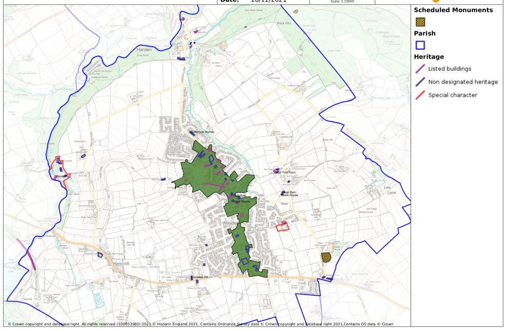 Figure 5 Wilsden Heritage Assets
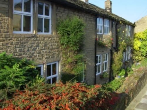
Former Three Horseshoes, 94 Main Street
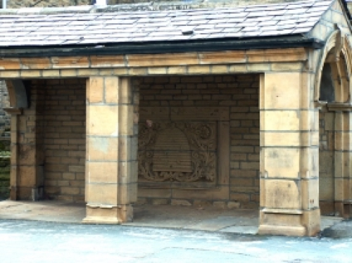
Beehive stone shelter at junction of Royd St & Main St
POLICY W/BH1 WILSDEN NON-DESIGNATED HERITAGE ASSETS
The Plan identifies the following buildings and structures as Wilsden Non-designated Heritage Assets of local heritage interest as specified in CBMDC Core Strategy Policy EN3.
W/BH1-1 Wilsden Conservative Club building, Wellington Street
W/BH1-2 The New Inn, 114 Main Street
W/BH1-3 The former Three Horseshoes, 96 Main Street
W/BH1-4 Rose Cottage Farm, Main Street and the associated small paddock.
W/BH1-5 Barns to the south of St Matthew's Church, Main Street
W/HB1-6 The Tap Yard, Springhill Place
W/BH1-7 Well House, Main Street
W/BH1-8 Prospect Mill
W/BH1-9 Providence Mill
W/BH1-10 Well House Mill
W/BH1-11 3 & 6-24 Moss Row
W/BH1-12 1 & 2 Dyehouse
W/BH1-13 Royd House, 130 Main Street
W/BH1-14 Beehive stone shelter at junction of Royd Street and Main Street
W/BH1-15 Norr Manor
W/BH1-16 Trinity Chapel
W/BH1-17 3 Springhill
W/BH1-18 Ling Bob Mill
W/BH1-19 5 & 7 Birkshead
W/BH1-20 The Old Vicarage - 60a Laneside & 2 The Old Vicarage
W/BH1-21 Moorside House
W/BH1-22 Hallas Grange & Hallas Mount, Hallas Bridge
W/BH1-23 1, 3, 5 & 7 Greenley Hill
W/BH1-24 Lane End House, Lane Side
W/BH1-25 Former Animal Pound, Mytholme
W-BH1-26 Bents House, Hallas Bridge
W/BH1-27 Hallas Bridge, 2-12
W/BH1-28 Cherry Tree Row 1-12
W/BH1-29 Dales Cottage, Bank Bottom
W/BH1-30 The Old Manse, Chapel Row
W/BH1-31 167 Harecroft
W/BH1-32 Anslea and Moss Cottage, Hallas Bridge
W/BH1-33 Former National School, 87 and 89 Main Street
W/BH1-34 1-6, Butterfield Homes, Harden Lane
W/BH1-35 2--16 Shay Gate, Haworth Road
W/BH1-36 Shay Gate Farm and Barn, Haworth Road
W/BH1-37 Upper Bents Farm Cottage and Barn, Bents Lane
W/BH1-38 Norr Fold Farm Cottages, Coplowe Lane
W/BH1-39 Nook House & Nook Barn
Development proposals will not be supported that harm the historic significance and setting of Wilsden Character Buildings and Sites, as identified in the Schedule.
Development proposals will be required to take into account the character, context and setting of these locally important assets including important views towards and from them. Development will be required to be designed appropriately, taking account of local styles, materials and detail.
3.3 Wilsden Conservation Area
3.3.1 There is one Conservation Area in the Parish - Wilsden. This was designated in 1977, and covers the historic core of the Village, following a linear pattern along Main Street. It is where a significant proportion of Wilsden's heritage assets are to be found; over half of the Listed Buildings in the Parish are located within it, for example.
3.3.2 Its Conservation Area status means that there is greater control over development within, or affecting its setting, including such matters as demolition, landscaping and trees, and the display of advertisements. In 2007 CBMDC produced a Conservation Area Appraisal for Wilsden. This sets out the special characteristics of the Conservation Area, and how this can be safeguarded and enhanced. Of special mention is that it includes a summary of important features and details, which lists the existing features and details that contribute to the character of the Conservation Area.
3.3.3 The consultation showed that the community supports and takes pride in the designation of the historic core of Wilsden as a Conservation Area, but there is concern that some development has taken place within it of poor design and not in keeping with, and, in some cases, has detracted from its distinctive character.
3.3.4 Special care is also needed in the location and design of development proposals close to Wilsden Conservation Area. Inappropriate development immediately outside the Conservation Area can, and has had, a detrimental effect on the character and setting of the area. Prior to this Plan there has been no clear definition of the area that is described as being immediately outside the Conservation Area. This Plan seeks to provide clarity to this definition by specifying the area surrounding the Conservation Area boundary that can be considered to affect the setting.
3.3.5Development proposals close to the Conservation Area are particularly important to its setting and these will be expected to respect the character and appearance of Wilsden Conservation Area. They should seek to meet the same standards of design as those within the Conservation Area.
POLICY W/BH2 WILSDEN CONSERVATION AREA
Development proposals within or that affect the setting of the Wilsden Conservation Area must respect and enhance its special character in high quality design proposals that accord with the guidelines set out in Wilsden Conservation Area Appraisal. Any development that when viewed from and/or within the Conservation Area and is up to at least 50 metres outside of the boundary, will be considered to affect the setting of the Conservation Area.
3.4 Hallas Bridge and Birkshead Special Character Areas
3.4.1 In addition to the designated Wilsden Conservation Area, the consultation and analysis conducted as part of the development of the Neighbourhood Plan showed that there are other parts of the Parish which are important for their character and the contribution they make to the local identity and distinctiveness.
3.4.2 In particular, it highlighted two areas – Hallas Bridge and Birkshead – each of which has its own distinct and special character. This special character is derived not only because each has historically and architecturally important buildings, but also because of their history, layout and the open spaces within them.
3.4.3 Although they may not be of sufficient historic or architectural interest for designation as Conservation Areas, it is important that their special character should be conserved because of their intrinsic quality and their local importance, and that all new development should be designed with this is in mind.
Hallas Bridge Special Character Area
3.4.4 Hallas Bridge is a hamlet situated off Bents Lane between Cullingworth and Wilsden and is approximately a mile west of Wilsden. The boundary of the special character area is shown below along with details of specific heritage assets.
3.4.5 Originally a collection of farms and farmsteads, the building of Bents Mill and associated workers' cottages in the late 18th Century marked the beginning of the area's development. It is relatively self-contained, set within a steep valley and surrounded by attractive thick woodlands and open countryside. Its self-contained nature and distinct character and history contribute greatly to a sense of place and identity. The hamlet is dominated by the imposing former Bents Mills, which is now in residential use. Bents Mills is a (Grade 2) Listed Building in view of its special architectural and historic interest.
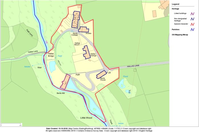
Figure 6 Hallas Bridge Special Character Area
3.4.6 Scattered across the hamlet are other dwellings, many developed in the 19th Century to house mill workers. These include short rows of terraced properties. Many of the buildings have retained their original traditional features and design and are relatively unmodernised. Traditional building materials and design predominate. It retains much of its traditional roofscape and skyline, due to the general retention of chimneys and original roofing materials. With the exception of the listed Bents Mill all dwellings are included as non-designated heritage assets and covered by Policy W/BH1. There is a predominance of mature trees, which enhance its character and its rural setting.
3.4.7 Development has been gradual and of modest scale. There are also significant open spaces, which add to its value and help maintain its original character. There are several other buildings that have been identified as being of some local architectural and historic quality. These include Bents House, Hallas Mount and Hallas Grange.
Birkshead Special Character Area
3.4.8 This is a small cluster of terraced former mill cottages off Birkshead Drive in the Parish of Wilsden. Densely developed, they are located on a prominent position overlooking the valley of Wilsden Beck, with good views over the surrounding countryside. The boundary of the special character area along with designated heritage assets is shown below. The immediate setting of the area is dominated by a mixture of modern developments to the north and east and open fields to the south and west.
3.4.9 Despite this dominance by the modern housing development that replaced Birkshead Mill the area is the most complete example of the pre-Industrial Revolution agricultural hamlets that were gradually merged into the modern village during the 19th Century. Fox's map of 1818 clearly shows that many of the cottages in the special character area predate Birkshead Mill.
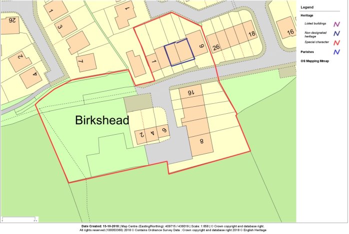
Figure 7 Birkshead Special Character Area
3.4.9 At its height Birkshead Mill (which closed in 2002) was one of the major employers in the area, providing work for nearly three hundred people. Unlike many of the Wilsden mills where the workforce lived in cottages immediately around the mill the Birkshead workers lived in the main village that was built up during the 19th Century.
3.4.10 Birkshead comprises three short groups of terraced houses, many of which predate the opening of the Birkshead Mill in 1820. They show a high degree of uniformity in design. Generally, they are two storeys with slate roofs and built from local sandstone. A significant number of the buildings have retained many of their traditional features and details. Modern extensions to the properties are limited. They follow common linear build lines generally set behind small front gardens. A feature is that one of the terraces is set perpendicular to the road. They provide a contrast with twentieth century suburban style housing developed on the former mill site.
3.4.11 No 5 is dated 1768 with the inscription John Hill MB, who as well as being a medical practitioner was a major local landowner. No 1 is the former Mill Owner's cottage and is larger and features a higher level of architectural ornamentation than the other cottages. The fields to the south add to the character of the area and give impressive views in and outside of Birkshead, as well as a green break between the hamlet and the surrounding settlements.
3.4.12 A particularly interesting characteristic of the hamlet is the network of paths that link it to the surrounding communities. Many were created in the 18th Century to link mill workers' cottages to their place of work. The most striking example of these are from the site of the former Birkshead Mill to the communities of Ling Bob and Wilsden. There are no buildings included on the Statutory List of Buildings of Special Architectural or Historic Interest.
POLICY W/BH3 HALLAS BRIDGE AND BIRKSHEAD SPECIAL CHARACTER AREAS
Within the Hallas Bridge and Birkshead Special Character Areas as identified on Figures 6 and 7, development proposals should be of high quality and must be designed so as to conserve and enhance their distinctive local character, having regard to scale, density, height, landscape, layout, materials and access.
All dwellings in Hallas Bridge are either listed or Non-Designated Heritage Assets listed in Policy W/BH1.
Hallas Bridge is wholly washed over and Birkshead is partially washed over by the Green Belt. An important part of the setting of Birkshead is that the open aspect of the fields to the south are retained.
The setting of both Special Character Areas of the Wilsden Area with Hallas Bridge and the way the area has developed since the Industrial Revolution.
3.5 Hallas Bridge Conservation Area
3.5.1 The analysis and consultation undertaken as part of the development of the Plan considered that the quality and interest of Hallas Bridge built and natural environment was so significant that it was worthy of designation as a Conservation Area. This reflects not only the quality of the built environment within Hallas Bridge with many buildings of historic and architectural interest, some of which are 'Listed', but also its history as a mill settlement and the quality of the green spaces in and around it.
3.5.2 The consultation shows strong support for its designation, which would provide protection for one of the most special and valuable areas of architectural and historic interest in the Parish. It is recognised that legislation does not allow a Neighbourhood Plan to designate a Conservation Area – this would need to be done by CBMDC. The Plan can, however, highlight the need, case and local importance for such a designation.
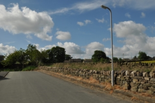
3.6 Dry-stone Walls
3.6.1 The attractiveness of Wilsden is not only a result of the buildings to be found within it, but a combination of topography, trees, open spaces and other features that characterise the Parish. Particularly important are the dry-stone walls. These were the traditional field boundaries in this part of Yorkshire and are an important and much appreciated part of the character of the Parish. They are also of bio-diversity value providing important linear wildlife corridors especially for invertebrates as well as supporting lichens and other plant life.
3.6.2 Their importance to the community is not only reflected in the findings from the consultation but also studies and reports such as Bradford landscape character assessment description of Wilsden Valley and the Yorkshire South Pennine Fringe Landscape both of which draw attention to the importance of dry-stone walls in the local area. Some of these walls are protected, including a pair of crossed pathways which has Listed Building Status. However, the majority do not have special protection, with some falling into disrepair and others being removed as part of development schemes. This network of dry-stone wall across the Parish is especially valued by residents and visitors. This is not only reflected in the findings of the consultation, but also the number of people who volunteer their time in repairing them through bodies such as the Wilsden Wall Building Group.
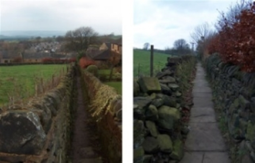
Listed walled footpaths Characteristic dry-stone walls
POLICY W/BH4 DRY-STONE WALLS
Dry-stone walls are of particular importance to the history and distinctive character of the Wilsden area as identified in the Natural Environment section of this Plan and highlighted in Policies W/NE4 and W/NE5 and Policy PN1D of the CBMDC Core Strategy. Development proposals should be designed to retain or enhance dry-stone walls where appropriate.
The Wilsden Design Code provides guidance on boundary treatments in new developments and Policy W/HO4 details how this should be addressed in development proposals. Development proposals that would result in the removal of, or have an adverse impact on, a natural stone wall will only be supported where it can be demonstrated that the benefits of the development will outweigh the harm caused by the removal of the wall or a replacement dry-stone wall of equivalent value is provided in a suitable location in the Parish. Any development proposal within Wilsden Conservation Area or in the countryside as defined in Policy W/HO2 that will involve boundary treatments as part of a development should use natural stone walls.