Draft South Pennine Moors SPA/SAC Planning Framework Supplementary Planning Document
(4) 3. Enabling development: the strategy
(8) Overview
3.1 This SPD provides protection for the South Pennine Moors SPA/SAC and mitigation for impacts from development through:
- A presumption against certain types of development within 400m of the South Pennine Moors European sites;
- A requirement that any development proposal (including non-residential development) within 2.5km of the European site boundary will need to undertake particular checks for supporting habitat, and depending on these findings, ensure any impacts are addressed through mitigation before any application can be approved;
- Any development within 400m – 7km that results in a net increase in residential units(or certain other types of development), will need to secure mitigation for recreation impacts through developer contributions (or bespoke mitigation).
(10) The zone approach
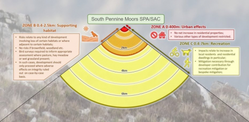
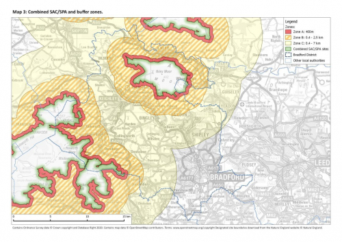
3.2 The different zones are summarised in Figure 1 and Map 3.
(6) Process for applications within different zones
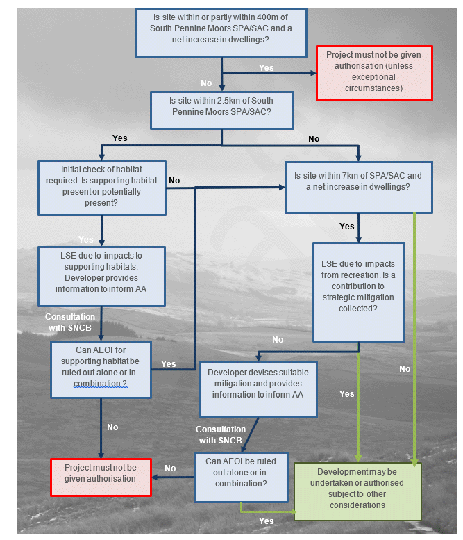
3.3 Figure 2 provides a flow-chart to show the checks necessary for individual planning applications, in line with Policy SC8.

Figure 2: Flow-chart indicating necessary checks for residential planning applications. Abbreviations used are: LSE likely significant effects; AA appropriate assessment; AEOI adverse effects on integrity; SNCB Statutory Nature Conservation Body (Natural England).
3.4 In the rest of this section we consider in more detail some of the particular steps shown in the flow chart, in particular:
- Exceptional circumstances and the 400m zone;
- Identifying sites within 2.5km where supporting habitat is present or potentially present;
- Ruling out adverse effects on integrity for sites where supporting habitat is present or potentially present;
- Which developments are required to provide mitigation within 0.4-7km.
Exceptional circumstances within the 400m zone
3.5 Instances of exceptional circumstances are very rare. The 400m zone is necessary to provide protection for the supporting habitat around the periphery of the European site boundary, to reduce the impacts from recreation and to address urban effects. As such the presumption is that there will be no net increase in dwellings as these pose particular risks (from urban effects, loss of supporting habitat or recreation) and the only types of development that might therefore be permitted would be replacement residential dwellings or the following (which would require assessment on a case-by-case basis):
- Use Class C1, Hotels, guest houses;
- Use Class C2, Specialist housing, i.e. sheltered housing/nursing home, residential institutions such as boarding schools/training colleges or hospitals
- Use Class C3, Replacement dwellings only.
Identifying sites within 2.5km where supporting habitat is present or potentially present
3.7 Within the 400m-2.5km zone it is necessary to check for supporting habitat that might be functionally linked to the SPA and the developer will be required to provide further information. The following types of site would not generate credible risk and therefore likely significant effects would be ruled out if the entire site was comprised one or more of the following:
- Brownfield sites;
- Within an existing farm or house curtilage;
- Within a settlement boundary or within 25m of a settlement boundary;
- Within 25m of a main road;
- Woodland;
- Arable[1].
3.8 If the site does not fall into the above categories, habitat checks by a suitably qualified ecologist with experience of the relevant bird species will be necessary to identify whether a site is likely to provide suitable habitat. Given the presence of the 400m zone, risks are only likely in relation to those species that will move beyond 400m from the SPA (Golden Plover, Curlew, Twite and possibly Lapwing). Golden Plover is the main species of interest likely to be encountered. The use of areas outside the SPA by these birds will be patchy and only certain areas are likely to be important (Bertinussen, 2018). The following habitats, if present within the red line boundary or adjacent to it, would be indicators of credible risk:
- Grassland with abundant molehills;
- Semi-improved pasture or rough grazing;
- Hay-meadows;
- Floodplain grassland or wet grassland habitat.
3.9 The habitat checks will need to be site specific and extend to take into account any supporting infrastructure such as roads or power lines that may be required for the proposed development and the land directly adjacent to the site.
3.10 The above will be sufficient to identify where likely significant effects will be triggered and therefore a need for further evidence (including species surveys) to inform appropriate assessment. In some circumstances, where sites outside of the SPA are identified as functionally linked but the level of use by SPA birds is sufficiently light, it may be that a conclusion of no significant impact on the populations for which the site had been classified can be reached. As a rule of thumb, if it can be shown that less than 1% of the population of the SPA are impacted by the proposal it may be possible to rule out a likely significant effect.
3.11 In due course it is anticipated that Natural England advice and modelling will be available (drawing on the modelling results in Bertinussen, 2018), to provide further information of areas of high risk and further clarification as to where bird surveys will be necessary.
Ruling out adverse effects where supporting habitat is present or potentially present
3.12 Where initial habitat surveys have identified the potential for supporting habitat then bird surveys will be necessary. Separate guidance on bird survey methods has been produced by the Council[2].
3.13 Developers will need to provide information to inform appropriate assessment in the form of habitat and bird survey results and this will need to cover the potential scale of any loss and/or deterioration of the supporting habitat in light of the conservation objectives[3] for the SPA. Areas that hold large field systems (e.g. over 5ha[4] in size), where old field systems are present or where there are fields supporting high earthworm density (e.g. abundant molehills) are likely to be particularly important. This may mean that mitigation measures will be necessary and if it is not possible to rule out adverse effects on integrity, after taking account of any mitigation measures, then the project will not be authorised. Options for mitigation are limited but could include:
- Modifying the design to lessen or avoid impact;
- Creation of open habitats suitable for the SPA qualifying features;
- Grassland management to provide suitable/improved breeding or foraging habitat for qualifying features in other locations (closer to the SPA);
Which developments are required to provide mitigation within 0.4-7km.
3.14 Mitigation has been established strategically, ensuring an appropriate, adequate and robust level of mitigation. By contributing to this strategic approach, individual developments can ensure compliance with the legislation in relation to recreation impacts. Mitigation is focussed around recreation from new residential growth and Table 1 summarises the relevant types of use (within the 0.4 - 7km zone) where new planning applications will be expected to provide mitigation and how the contributions for different types of use can be calculated. Details relating to the mitigation and the cost are set out in the subsequent section.
Table 1: Summary of types of use which are expected to provide developer contributes for mitigating recreation impacts (development within 7km radius of the South Pennine Moors SPA/SAC).
|
Use Class |
Use description |
Likely significant effect? |
Mitigation |
Contribution for recreation mitigation |
|
C1 |
Hotels, guest house |
Possibly |
Case by case basis |
1 room = 1 residential unit |
|
C2 |
Specialist housing, i.e. assisted living |
Yes |
Contribution as per C3 housing. |
1 room = 1 residential unit |
|
C2 |
Specialist housing, i.e. sheltered housing/nursing home |
No |
No publicly available parking capacity if in proximity to SPA/SAC |
|
|
C2 |
Residential institutions, i.e. boarding schools, residential colleges and training centres |
Yes |
Contribution as per C3 housing. No publicly available parking capacity if in proximity to SPA/SAC. |
1 room = 1 residential unit |
|
C2 |
Residential institutions, i.e. hospitals |
No |
No publicly available parking capacity if in proximity to SPA/SAC |
|
|
C3 |
Net additional dwelling |
Yes |
Standard as per this report |
Contribution for each unit |
|
C3 |
Replacement dwelling |
No |
No |
|
|
C3 |
Extension or granny annex |
Yes |
As per net additional dwelling |
Contribution for each unit |
|
C3 |
Retirement dwellings |
Yes |
Contribution as per C3 housing. |
Contribution for each unit |
|
C4 |
Houses in Multiple Occupation <6 residents |
Yes |
Contribution as per C3 housing. |
HMO = 1 unit |
|
Houses in Multiple Occupation (Sui generis over 6 residents) |
Yes |
Contribution as per C3 housing. |
Every extra room>6 residents is: 1 unit |
|
|
Self-catering, caravan and touring holiday accommodation |
Yes |
Contribution as per C3 housing. |
Each space/holiday unit = 1 residential unit with option to adjust down for occupancy |
|
|
Gypsies and travellers |
Yes |
Contribution as per C3 housing. |
1 pitch = 1 residential unit |
|
|
University managed student accommodation |
Yes |
Contribution as per C3 housing. Potential for exemptions for large scale managed student accommodation assessed on case by case basis. |
Each self contained cluster flat or studio=1 unit |
[1] Note that there is limited arable land within the District and also that arable land can be used by the SPA qualifying features for foraging, but in the Bradford area is considered of limited importance beyond 400m from the SPA boundary
[2] WEBLINK TO ADD
[4] This is drawn from Whittingham et al who recorded a mean field size of 5.04 (range 0.60 – 19.4ha) and found larger fields were preferred.


