

Baildon Neighbourhood Plan (2026-2040)
2.0 Baildon Neighbourhood Area
Introduction
2.1The designated Neighbourhood Area is shown in Figure 3. Just over 17,000 residents live in the area, spread across an area of 1,143 hectares (4.41 square miles). Baildon is in the Aire Valley, between the city of Bradford and Rombalds Moor. It stretches from the River Aire, through Roberts Park, and along Otley Road, Charlestown and Tong Park, and up through numerous neighbourhoods right up to Baildon Moor.
2.2Baildon – A ‘Spatial Portrait’.
The Hill - Stretching from the River Aire in the south, up to Baildon Moor in the north, Baildon is built on a steep hill, rising to 925 feet at the trig point. This has many consequences for everyday life, especially transport.
The Space - Baildon is surrounded on 3 sides by open countryside, which makes the quality of life superb. It is bounded by the River Aire.
Our Heritage - Baildon benefits from being adjacent to the World Heritage site at Saltaire with all it has to offer, whilst also having its own local history stretching back around 3,000 years.
Our Community - With a population of 17,041 (2021 Census) Baildon has a wide range of housing and a warm and inclusive community. Baildon provides a variety of desirable lifestyles for people of all ages – families with children, older people, and young people starting out.
Our Economy - Whilst Baildon is ideally placed for those who commute to Leeds and Bradford (and further afield from the Airport), Baildon retains its own vibrant local economy. This includes:
- A vibrant and characterful hospitality sector
- A modest local retail centre in Baildon
- A wealth of small businesses and self-employment with many working from home
- Some larger employers along the Otley Road corridor
Getting Around - Baildon is fortunate to have retained its local railway station, although the service is infrequent (at the time of writing 1 service per hour in each direction between Bradford Forster Square and Ilkley). Bus services are limited (mainly 3 per hour between Baildon and Bradford via Shipley). Leeds Bradford Airport is 4 miles away. The Airedale corridor along Otley Road is a main arterial route for the Aire Valley but is very heavily congested with road traffic. The steep gradient of Baildon Hill means that, for many, car and bus transport is critical to people’s ability to enjoy local retail and community facilities. Parking is needed to help different sectors of the community such as an ageing population who are not mobile enough to climb steep hills and young families with buggies.
2.3Climate change and climate emergency is one of the most serious issues facing the world and actions to slow down and prevent climate change are being implemented globally. Baildon Town Council took the first step in acknowledging this in 2019 when it, along with other Councils, declared a climate emergency. BTC followed this with an Environmental Policy in January 2021. This sets out the Council’s overarching environmental commitments and encompasses sustainability issues related to land, water and air, design, transport, economic development and biodiversity. Whilst the Water Framework Directive is a matter for Bradford Council to lead on, Baildon Town Council will work as appropriate with Bradford Council on initiatives to improve the quality and management of water courses in the Parish. Baildon Town Council will also work with Bradford Council on their initiatives (amongst others) to improve air quality, recycling and sustainable design. These issues underpin all the Policies in the plan.
Village or Town?
2.4The identity and boundaries of Baildon are often misunderstood. With a population of over 17,000, comprising of many different neighbourhoods, Baildon is not a village as most people would understand the term. This was recognized by Baildon Parish council in 2013 when it decided to rename itself Baildon Town Council.
2.5However, the concept of “Baildon Town Centre” did not gain popular consent, with most residents still referring to “the Village Centre”. Bradford Council designate it a ‘Local Centre’ and Baildon Centre is a significant cluster of retail and commercial businesses near the top of Baildon Hill and on the edge of the moors. However, it is smaller than other Town Centres serving similar populations. The reality is that many who live along the “Otley Road corridor” and adjacent neighbourhoods, choose to use other centres (Shipley, Saltaire, Guiseley) rather than climb the steep hill into Baildon.
Baildon Town Council in October 2021 agreed that it would maintain reference to Baildon Village Centre as one of the many neighbourhoods making up the Town of Baildon Minutes of the Town Council decision to use the term Baildon Village Centre
2.6Although the reality of Baildon Hill influences every aspect of life in Baildon wherever you live, the terms ‘upper’ and ‘lower’ Baildon were dropped by Baildon Town Council due to the social impact of those terms, preferring a reference to more precise neighbourhood areas.
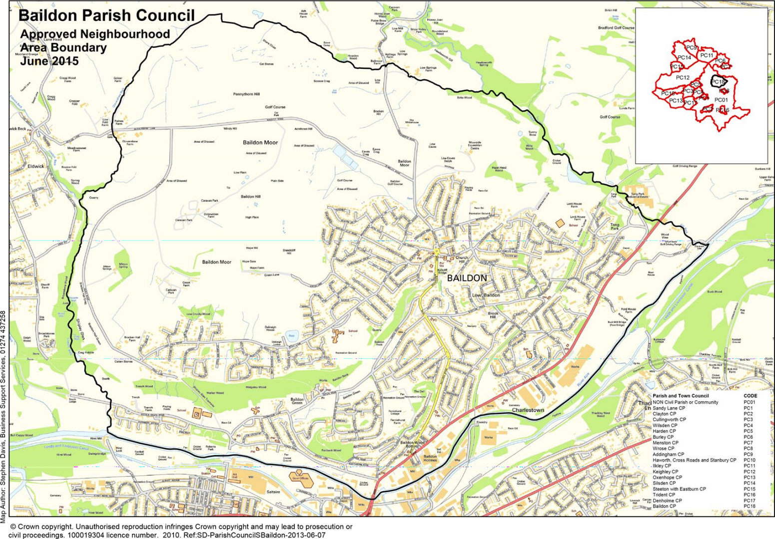
Figure 3. Baildon Neighbourhood Area Boundary. (PSGA AC0000823741)
Other background information about Baildon.
Housing
2.7In 2021 there were 7,757 households in the town (parish). Of these 32% (2,494 households) were single person households, which is broadly similar to the proportion for Bradford Council area as a whole at 31%. 64% (4,975) of households in Baildon were single family households, which is slightly higher than in Bradford (62% of households). In terms of tenure, private ownership (including both homes owned outright and those with a mortgage) is relatively high in Baildon at 76% (5,880) compared to 62% for Bradford and social renting correspondingly low at 10.7% (837) (15% in Bradford). Private renting now makes up 13.3% of households (1,040) in Baildon, which is lower than the proportion for Bradford at 23%. (Source: Office for National Statistics https://www.ons.gov.uk/visualisations/customprofiles/).
2.8The built-up area of Baildon is bounded to the north, east and west by part of the designated West Yorkshire Green Belt. Green Belt (GB) is one of the aspects of the country’s planning system that is the best known with national planning policy attaching great importance to them. The fundamental aim of GB is to prevent urban sprawl by keeping land permanently open. GB’s essential characteristics are their openness and their permanence. The current GB boundaries in the Baildon area were established in the saved policies of the Bradford Replacement Unitary Development Plan (RUDP), adopted in May 2005. These boundaries should only be amended where exceptional circumstances are fully evidenced and justified through the preparation and/or updating of Local Plans.
Transport
2.9Baildon is located on a steep hillside on the northern edge of the key transport routes through the Aire Valley, with very congested road connections towards either Bradford or Leeds along the congested Otley Road corridor. Baildon is fortunate to retain its own railway station, but rail travel is not optimised due to the absence of bus connections and low frequency train services.
Environment and Countryside
2.10Baildon has a range of corridors and spaces that contribute towards its Green and ‘Blue’ Infrastructure network. Blue infrastructure refers to water features, including ponds, lakes, streams, rivers and storm water provision, wetlands and canals and their banks. Key corridors include the valley of the River Aire (a regionally important Green Infrastructure corridor), Shipley Glen and the Gill Beck valley. Although the Leeds Liverpool Canal is not in the neighbourhood area connectivity to it for residents and wildlife alike is key for the health and wellbeing benefits it brings. Baildon Moor and Baildon Bank are also highly important components of this network. These corridors are detailed below.
2.11Flood risk is generally associated with the River Aire and its tributaries to the south of Baildon. There have been several historic instances of major flooding e.g. The River Aire at Roberts Park 2015. There are, however, identified areas of surface water flood risk (from poorly managed streams and culverts) across Baildon often associated with principal transport routes. See Supporting Actions in Policy 10.
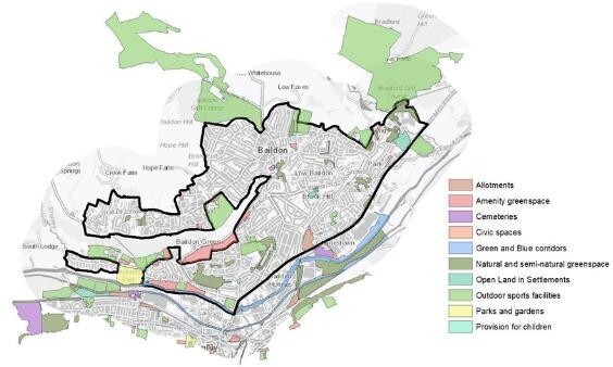
2.12Baildon has a wide range of identified open green spaces see Policy 12 and figure 4.
2.13Baildon Moor and the countryside to the north, east and west of the settlement contain several important biodiversity and geological designations. These include:
- 5 Local Wildlife Sites (LWS) – Baildon Bank; Baildon Moor; Fairbank Wood; Shipley Glen; Tong Park with Hawksworth Spring Wood
- Local Geological Sites (LGS) – Baildon Bank, Baildon Green Quarries; Baildon Moor; Shipley Glen.
People and Community
2.14Baildon’s population was 17,041 on Census Day 2021. Census data for Baildon
(http://citypopulation.de/en/uk/yorkshireandthehumber/wards/bradford/E05001341_baildon/)
Baildon has an older population than Bradford District and England. In 2021, one in four Baildon residents were aged 65 or older (Bradford 15.2%; England 18.3%). Conversely, under 16s in Baildon made up 17.0% of the population (Bradford 22.8%; England 18.5%).
2.15Baildon has two NHS registered healthcare facilities/GP surgeries/health centres covering Baildon and the surrounding area. Secondary (acute) healthcare is provided at Airedale General Hospital in Steeton and Bradford Royal Infirmary in the city.
2.16Baildon is considered to have a good range of community facilities and services to meet the day-to-day needs of the local population. Although the make up of the Village Centre retail offer is changing.
Business and Employment
2.17Economic activity rates in Baildon parish, like those for Bradford, are in line with national figures 58% of residents (8,181) being economically active, compared with 54.5% for Bradford and 58.6% for England.
2.18Baildon’s main area of employment lies in the south of the neighbourhood area, between the Otley Road (A6038) and the River Aire. This area provides the bulk of the jobs in Baildon jobs in a variety of business sectors, including manufacturing, retail, trade sales and leisure. Baildon village centre is a secondary area of employment.
Figure 4: Baildon - Open Space Overview – taken from the Draft Bradford District Local Plan February 2021.
(Source: Bradford Council PSGA AC0000823741)
Heritage
2.19There are four Conservation Areas in Baildon - Conservation Areas are areas of “special architectural or historic interest”, the character or appearance of which is desirable to preserve or enhance” (Section 69 of the Planning (Listed Buildings and Conservation Areas) Act 1990).
2.20The approach set out in Baildon Policies 14 – 17 is in general conformity with the approach set out in Core Strategy Policy EN3: Historic Environment that seeks to “preserve, protect and enhance the character, appearance, archaeological and historic value and significance of the District’s designated and undesignated heritage assetsand their settings.”This Neighbourhood Plan in consultation with the Baildon Civic and Historical Society and the public has identified 25 non-designated heritage assets in Baildon. Non-designated heritage assets are Heritage Assets of importance to Baildon which currently have no other designation within the Planning system, e.g. Listed Building or being in a Conservation Area.
2.21Roberts Park to the southwestern edge of Baildon NA and the northern edge of Saltaire World Heritage Site (SWHS) in Shipley Ward, is a nationally important site and a Registered Park of Special Historic Interest in England.
2.22There is a total of 81 entries on the National Heritage List for England in Baildon, including Listed Buildings, the majority of which (43) are Grade II Listed. There is one which is Grade II* Listed (Baildon Hall). 37 Scheduled Monuments are found close to the western and northwestern edges of the built-up area on Baildon Moor.
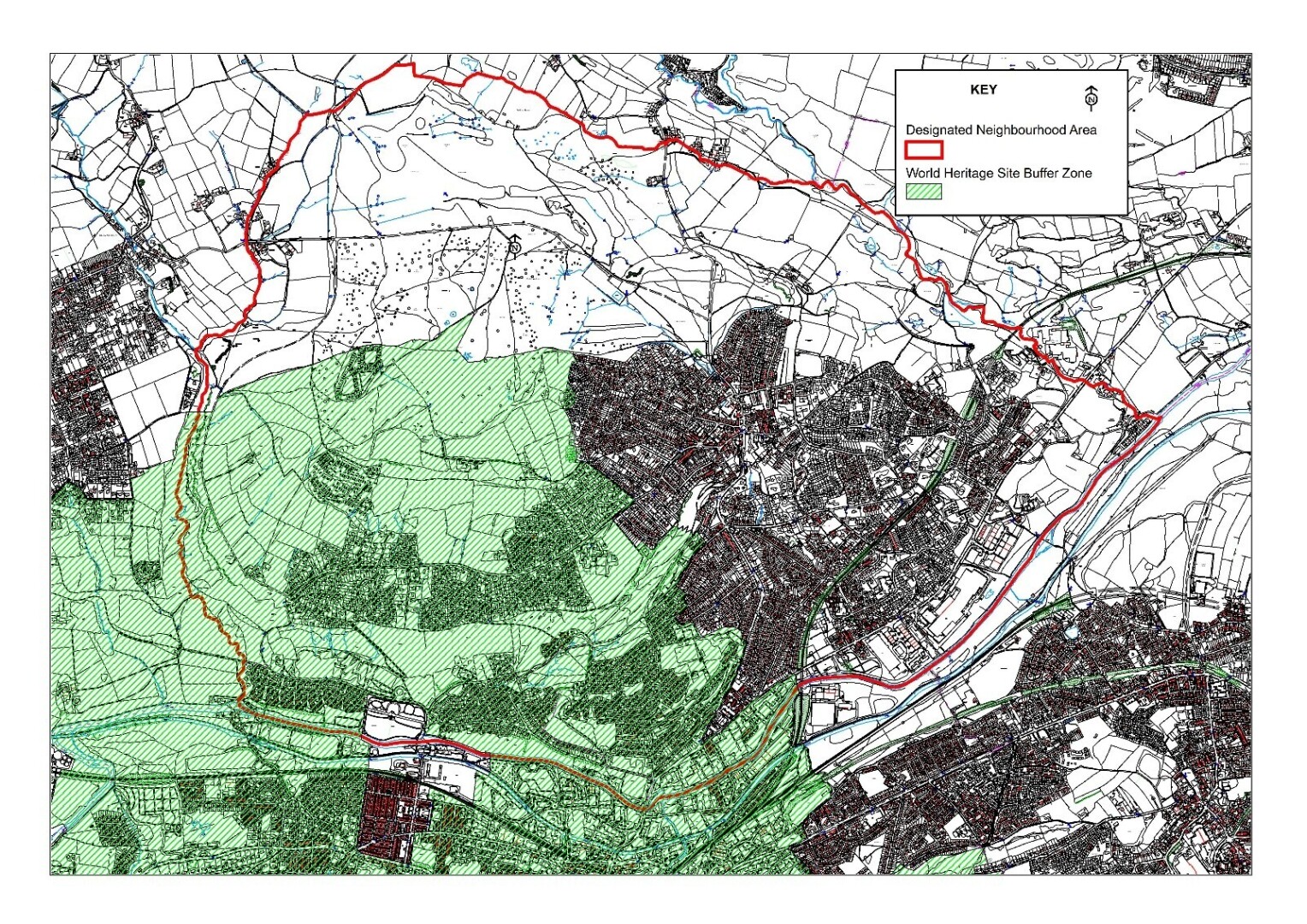
2.23Land in the Baildon Neighbourhood Area ie. to the northwest and the west of Baildon lies within the 500m Buffer Zone of the SWHS. This zone has implications for development as it may affect views into and out of the SWHS and should be protected.
Figure 5. Map illustrating the overlay World Heritage Buffer zone on the Baildon Neighbourhood area Crown copyright [and database right] 2025 OS 0100055940 on behalf of Baildon Town Council Ac000082374
Background Note: Bradford Council’s Baildon Ward Boundary
The Bradford Council Baildon Ward Boundary is not co-terminus with the Baildon Neighbourhood Area (NA) i.e. the Baildon Town Council area.
In 2024 the Local Government Boundary Commission for England (LGBCE) reviewed the Bradford Council Ward boundaries, and the final proposals make little change to this boundary. Baildon Town Council argued strongly for a re-alignment to allow the Baildon Riverside area to be included within the Baildon ward, but this was not supported by the LGBCE.
Key points of difference therefore remain and are:
- Baildon Riverside (Coach Road and Higher Coach Road) is to remain in Shipley ward but is included in the NA.
- Esholt remains in the Baildon ward but is not in the NA.
- Some parts at the eastern edge of Baildon (including Tong Park industrial estate) are not in the NA but are included within the Baildon ward.
