

Baildon Neighbourhood Plan (2026-2040)
5.0 Planning Policy Context
National Planning Policy and Neighbourhood Planning
5.1This section describes the National Planning Policy Framework (NPPF) context (as revised in December 2024 and amended February 2025) and references some of the key Bradford and District Policies which inform the NDP planning process.
The NPPF sets out in paragraphs 7 and 8 that the purpose of the planning system is to contribute to the achievement of sustainable development, and that the planning system performs an economic role, a social role and an environmental role.
5.2Neighbourhood Development Plans (NDPs) must be consistent with national planning policies and advice; and be in general conformity with the strategic planning policies for the area. It is therefore important that as the Baildon NDP is prepared, the emerging draft policies reflect this higher-level planning framework.
5.3The benefit of neighbourhood planning is set out in paragraph 29 of NPPF:
“Neighbourhood planning gives communities the power to develop a shared vision for their area. Neighbourhood plans can shape, direct and help to deliver sustainable development, by influencing local planning decisions as part of the statutory development plan. Neighbourhood plans should not promote less development than set out in the strategic policies for the area or undermine those strategic policies.
Strategic Planning Policy Framework for Bradford District
5.4Strategic planning policy is primarily and currently (early 2025) set out in the City of Bradford Core Strategy Development Plan Document (“the Core Strategy”) adopted on 18th July 2017 and the preceding Replacement Unitary Development Plan (RUDP) adopted on 15 October 2005. Core Strategy sets out strategic core and thematic planning policies for the long-term development of the wider District, rather than just the city of Bradford. Those saved policies in the RUDP not superseded by policies in the Core Strategy remain part of the development plan for Bradford. The development plan for the area also includes the Waste Management Development Plan, Bradford City Centre Area Action Plan, Shipley and Canal Road Area Action Plan, and other ‘made’ neighbourhood plans. The Baildon NP must be in general conformity with the strategic planning policies for Bradford. The following section below summarises some of the relevant Bradford Policies that this draft NP has considered.
5.5Part B of Core Strategy Policy AD1 (https://www.bradford.gov.uk/Documents/planningStrategy/10/ Adopted%20core%20strategy/Section%204.2%20-%20Airedale.pdf) outlines how development including housing provision will be delivered in the Airedale sub-area.
5.6For Baildon, it states: “Baildon will see the creation of 350 new homes during the Plan period including from sites within the urban area together with some local green belt changes in sustainable locations and associated community facilities”. The relevant parts of Bradford’s Core Strategy as they relate to Bailon are quoted directly over the following pages. These comprise extracts from the existing planning policy framework for the District, within which the Baildon Neighbourhood Development Plan must sit”.
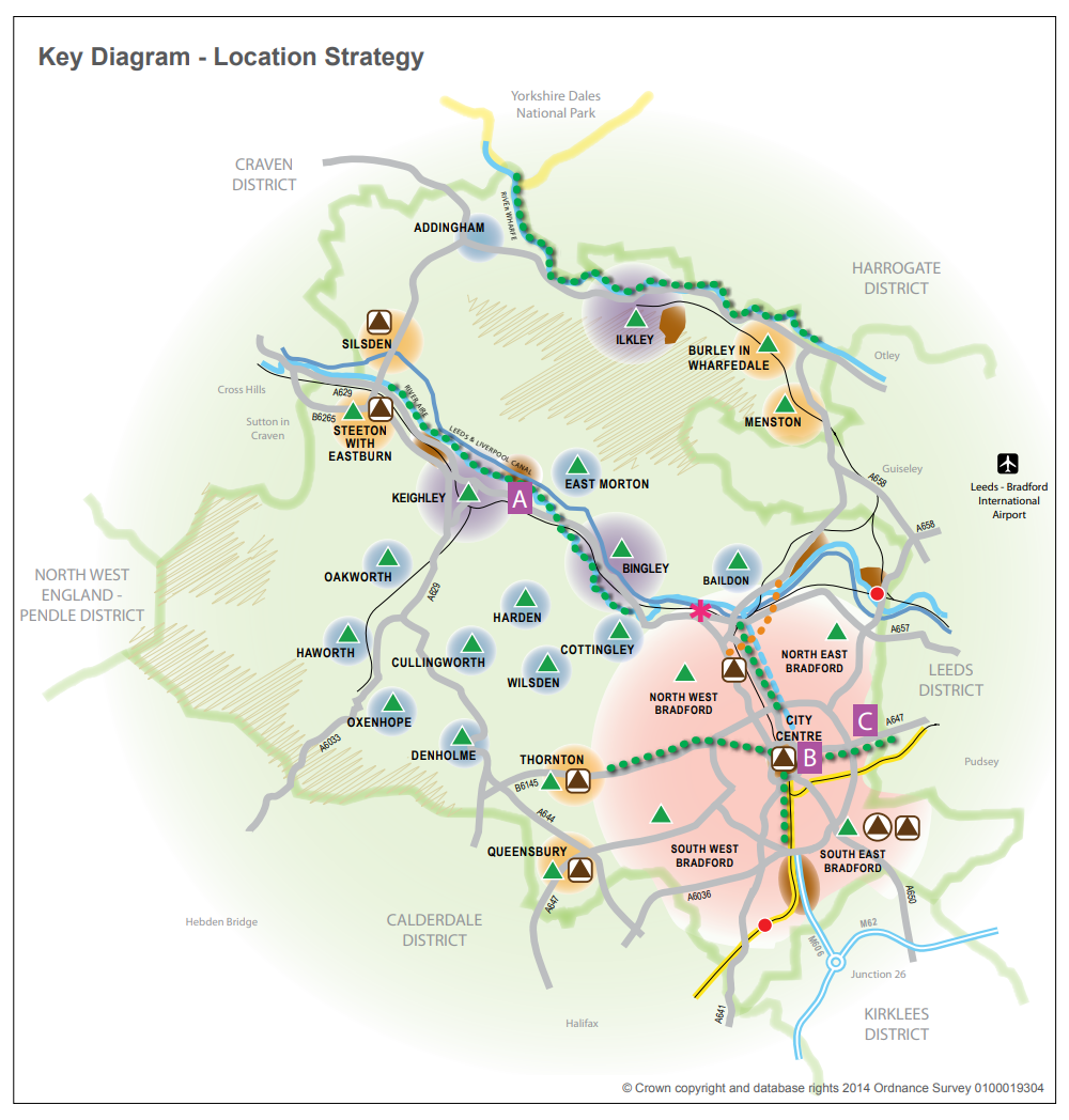
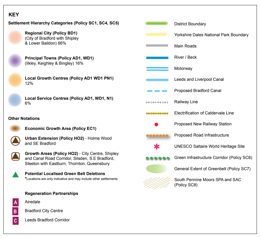
5.7These extracts highlight that much of the Baildon Neighbourhood area (down to Otley Road) is categorized as a Local Service Centre, with consequently lower levels of expected development. However, the area immediately north of the River Aire, and south of the Otley Road, is classified as part of the “Regional City of Bradford including Shipley and Lower Baildon”, which is the prime focus for new development in the District. This is considered in more detail below in the Section on Economy.
Bradford’s Core Strategy
The Bradford Core Strategy sets out Strategic Core policies for the District up to 2030 and those relevant to Baildon are summarised as follows:
Policy SC4: defines a Hierarchy of Settlements. The hierarchy of settlements is as follows:
- Regional Centre
- Principal Towns
- Local Growth Centres
- Local Service Centres and Rural Areas
The greater part of the Baildon neighbourhood area is included within the latter grouping of the hierarchy of settlements. The relevant section of SC4 in full is as follows; “Within the Local Service Centres of Addingham, Baildon, Cottingley, Cullingworth, Denholme, East Morton, Harden, Haworth, Oakworth, Oxenhope, Wilsden the emphasis will be on a smaller scale of development comprising both market and affordable housing, together with the protection and enhancement of those centres as attractive and vibrant places and communities, providing quality of place and excellent environmental, economic and social conditions.”
Bradford Core Strategy (2018) Locational Strategy map and key
BTC Commentary:
In summary there are positives and negatives associated with the positioning of Baildon as a ‘local service centre’ – on one hand the extent of housing development is limited, but on the other hand investment in infrastructure projects may be a lower priority. For Baildon, the Town Council regards infrastructure improvement as a top priority.
Policy SC7 sets strategic planning policy for Green Belt over the 15-year plan period.
This Policy sets out the tests for release of land from the green belt in sustainable locations, the potential to release green belt land without significantly undermining the functioning of the green belt at a local and strategic level and the extent to which the locations which pass the two tests above are otherwise constrained by other environmental designations and criteria. Bradford Council Core Strategy Policy SC7 Green Belt (https://tinyurl.com/CBMDC-green-belt-strategy)
Policy SC8: Protecting the South Pennine Moors Special Protection Area (SPA) and the South Pennine MoorsSpecial Area of Conservation (SAC) and their zone of influence.
The SPA/SAC lies outside the neighbourhood area but within the zone of influence. This will be an issue and any impact on the Saltaire World Heritage Site will be addressed in more detail through the Strategic Environmental Assessment (SEA)/Habitat Regulations Assessment (HRA) screening.
Sub Area AD1 sets out the strategic pattern of development.
A. Strategic Pattern of Development
In accordance with Policies H03 and EC3, Airedale will accommodate 8,450 dwellings in the period up to 2030 and an increase of new employment land of at least 30 Ha particularly in the digital technology sector. The broad distribution of housing development is shown as follows: -
Number of residential units
Keighley 4,500
Bingley 1,400
Silsden 1,200
Steeton with Eastburn 700
Baildon 350 (250 in Emerging Local Plan)
Cottingley 200
East Morton 100
Affordable housing requirements are set out in Policy HO11.
B. Urban Regeneration and Renewal and new housing provision will be focused on the following areas:
Baildon will see the creation of 350 new homes (see Policy 1 and 2 on housing) including from sites within the urban area together with some local Green Belt changes in sustainable locations and associated community facilities.
BTC Commentary:
Policy SP8 in Bradford’s emerging Local Plan sets out a minimum requirement of 250 dwellings, 2020 to 2038 (less than the 350 dwellings to 2030 in the Core Strategy). These new homes will be through a mix of committed sites (those under construction and sites that have planning permission) and site allocations – these could be brought forward through the Baildon NP or Bradford’s emerging Local Plan.
Bradford’s Core Strategy and emerging Local Plan 2020 acknowledge that due to the tightly drawn Green Belt such sites may have to come forward through changes to the Green Belt boundary. The emerging Local Plan will also put forward new policies on open spaces, green infrastructure and places of ecological significance.
C.Environment
- Protect and enhance landscape character and the range of habitats and diversity of species found in the wetlands, woodlands, Pennine Uplands and upland fringe areas of Airedale.
- Protect and enhance the integrity of the South Pennine Moors SPA/SAC and identify measures to support valuable upland fringe habitats. For the protection of the South Pennine Moors SPA, avoid and/or mitigate loss or deterioration of important foraging land within the SPA’s zone of influence, and mitigate the impact of increasing visitor numbers.
- Improve green infrastructure along the Airedale river, canal and public transport corridors.
- Protect and enhance river, beck and canal corridors, their value for biodiversity and heritage, potential for reducing flood risk and role in improving connectivity between urban and rural areas. Recognise that development could lead to opportunities for improving green infrastructure and flood storage provision, particularly in relation to the Upper Aire.
- Woodland, groups of trees and habitats are key elements in the landscape and efforts should be made to increase tree cover, particularly in areas where development might be located.
- Conserve and enhance the designated and undesignated heritage assets of the Airedale Corridor particularly those within the boundary of the Keighley Townscape Heritage Initiative and elements which make a significant contribution to the distinct character of this area including: the mills, chimneys and associated housing of its textile heritage in particular Saltaire World Heritage Site, the buildings and structures associated with the Leeds and Liverpool Canal and the prehistoric landscapes.
D.Transport
- Ensure that strategic patterns of development maximise the opportunities to use non-car modes of transport and reduce the overall need to travel through the application of accessibility standards (see Appendix 3).
- Develop bus rail interchange facilities at Steeton and Silsden Station and Bingley station including enhanced bus network and pedestrian/cycle links to/from both stations.
- Improve sustainable transport facilities and links within and between the towns and villages in Airedale, including cross valley links. Improve and provide new cycling and pedestrian infrastructure. Improve public rights of way and canal towpaths.
- Develop critical road infrastructure in accordance with the Connecting Airedale Transport Improvement Project including transport improvements to Hard Ings Road and Keighley Town Centre and any significant highway infrastructure required to facilitate development to the East of Silsden.
- Improve key transport corridors where feasible, including A650 (Airedale Corridor between Keighley and Bradford), A629/A644 (Keighley to Queensbury) and A6038 (Otley Road)
- Implement stronger demand management in Airedale as the economy recovers.
- Improve public transport access between Airedale, Regional Cities of Bradford and Leeds, as well as Craven.
- Improve public transport access to Leeds Bradford International Airport by encouraging more direct public transport connections from Keighley and Bingley and through the development of rail or tram train link via Shipley.
Sub Area Policy AD2: Investment Priorities for Airedale
To deliver transformation and change in Airedale through economic development, housing renewal and growth, and improved green infrastructure, community facilities and accessibility, public and private sector investment will be targeted:
- To improve public transport, particularly to Keighley, Bingley, Silsden and Steeton with Eastburn, to enhance the ease of movement and improve access to jobs within the Airedale Corridor particularly for disadvantaged communities.
- To support the regeneration of Keighley and Bingley town centres to deliver enhancements to the public realm, mixed-use retail and leisure schemes on key brownfield sites and improvements to the railway stations.
- To provide infrastructure to support site assembly, manage flood risk, and improve access between Airedale to Bradford City Centre, Shipley Town Centre as part of regeneration initiatives on the Shipley and Canal Road Corridor and the Connecting Airedale initiative (including Hard Ings Road Improvements).
- To take advantage of the proximity of the City Centres of Bradford and Leeds and deliver renewal of existing urban sites, training programmes and support site assembly including improvements to the quality and capacity of public transport along Airedale to Craven, the Regional Cities of Bradford and Leeds and through the application of accessibility standards.
- Support a number of local Green Belt releases in sustainable locations that meet accessibility standards in Keighley, Bingley, Silsden and Steeton with Eastburn through development site assembly, improvements to the quality and capacity of public transport, improvements to cycling and walking facilities.
- To support the development and extension of high-speed broadband especially in rural and other less accessible areas.
- To work with Yorkshire Water and the Environment Agency to understand fully the water and wastewater infrastructure requirements needed to support growth and ensure that development proposals are aligned with investment in asset management and catchment management plans.’
Neighbourhood Plan Policies
This section of the Baildon NP sets out the planning policies to manage development in Baildon up to 2040. Each section is structured as follows:
- name and summary of Baildon Town Council’s Objective,
- background and justification for the Policy area,
- the Policy,
- any Town Council Supporting Actions.
Whilst Policies are divided between the Objectives there are overlaps and synergies and so they should be read as a whole. There is a full Policies Map with detail for Baildon Village Centre.
