

Baildon Neighbourhood Plan (2026-2040)
9.0 Objective 4 - Heritage
To protect and enhance Baildon’s built environment by conserving designated and non-designated heritage assets and ensure any new buildings are well designed.
Introduction
9.1Baildon has a stunning setting on the north bank of the River Aire, the land rising steeply to the open land of Baildon Moor. This higher ground affords significant views across the Aire valley, north towards Ilkley Moor and from Baildon Moor to the Saltaire World Heritage (WHS) Site.
9.2National planning policy requires heritage assets to be conserved in a manner appropriate to their significance, so that they can be enjoyed for their contribution to the quality of life of this and future generations. Baildon’s Conservation Areas and statutory Listed Buildings already have existing protection under legislation and policy other than that provided by the NP.
Background and justification – Conservation Areas
9.3Baildon has three Conservation Areas and part of a fourth:
- Baildon (Figure 8) – designated 1981, boundary review in 2005 and adopted in 2005. Conservation Area Appraisal (CAA) 2009.
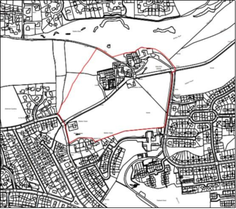
- Baildon Green (Figure 9) – designated 2009, CAA 2009.
- Baildon Station Road (Figure 10) – designated 1981, Conservation Area Appraisal 2009.
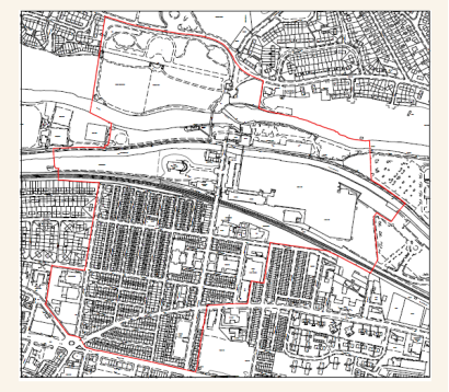
- Roberts Park falls within Saltaire Conservation area (Figure 11 shows the boundaries)
For further information visit Bradford Council’s Conservation Areas in Baildon (https://www.bradford.gov.uk/environment/conservation-areas/list-of-conservation-areas/)
Conservation Areas are areas of “special architectural or historic interest”, the character or appearance of which is desirable to preserve or enhance” (Section 69 of the Planning (Listed Buildings and Conservation Areas) Act 1990). Conservation Area designation adds extra planning controls including:
- Demolition of unlisted buildings
- Minor developments such as extensions, satellite dishes and boundary walls
- Works to trees
9.4The approach set out in Baildon Policies 14 – 17 is in general conformity with the approach set out in Core Strategy Policy EN3: Historic Environment that seeks to “preserve, protect and enhance the character, appearance, archaeological and historic value and significance of the District’s designated and undesignated heritage assetsand their settings.”
9.5In response to feedback from public consultation, this Plan identifies that all the Conservation Areas are overdue for review by Bradford Council. Furthermore, there is a case to review the extent and detail of the boundary of the Baildon Station Road Conservation Area to ensure that other non-protected heritage assets and elements contributing to the heritage setting in this area are protected – such as boundary treatments. Station Road is a significant and historic area of Baildon which would benefit from more protection from inappropriate developments.
A. Baildon Conservation Area
9.6The key features of the Baildon Conservation Area are:
- A mixture of 17th, 18th, 19th and early 20th century buildings
- A variety of building types and uses include retail units, offices, churches, mill buildings, industrial premises and dwellings, ranging from modest workers cottages to substantial houses such as Moorfield House and Batley House.
- Traditional natural building materials
- Mature trees are located within gardens and open spaces such as graveyards.
- Dramatic topography and important views across the Aire Valley towards Bradford.
9.7The 2009 Conservation Area Appraisal identified that the Baildon Conservation Area (also see Protected Green Spaces Appendix D) had an Authenticity Rating of 71%. This rating is based on an assessment of residential and retail buildings in the Conservation Area built prior to 1956 (259 properties in total) to ascertain the level of retention of original features chimneys, roofs, rainwater goods, walls, windows and doors, boundary walls, porches, bargeboards, bay windows and shopfronts. Not all buildings have all these features, and the scoring is adjusted accordingly. The 17 listed buildings in the Conservation Area were assessed as having an authenticity rating of 82%. The features and details that contribute to the essential character of the Conservation Area are:
- Original/traditional architectural detailing reflecting past architectural styles, including mullioned windows, stone corbels, cast iron rainwater goods and traditional timber windows and doors.
- Traditional roofscapes of stone slate roofs, chimney stacks and chimney pots.
- Traditional stone boundary walls and gateposts.
- Streets, lanes and folds of varying lengths and irregular widths that create important views and vistas.
- Historic street surfaces, including stone setts and stone flags.
Baildon Policy 13 identifies these features and details – this will act as a guide for applicants and will be used in the assessment of proposals as part of the development management process.
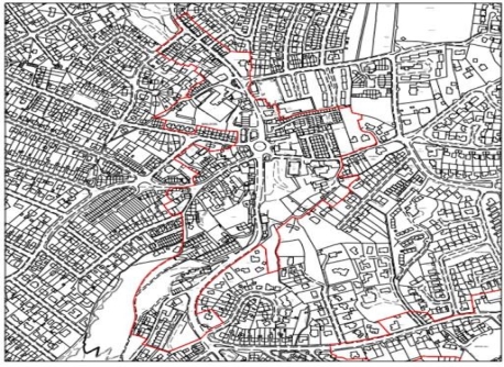
Figure 8. Baildon Conservation Area
Source: Bradford Council PSGA AC0000823741
B. Baildon Green Conservation Area
9.8Baildon Green is located on a small south-facing shoulder of land elevated above the River Aire but standing at the foot of the precipitous rocky outcrops of Baildon Bank, just over 1km to the southwest of the centre of Baildon village. The setting provided by the topography and open spaces at Baildon Green is integral to the settlement’s uniqueness and sense of place. The key features of the Baildon Green Conservation Area are:
- Topography and open spaces
- Use of traditional building materials – local sandstone for walls, roof slates, and boundary walls
- Timber for windows, doors and some guttering.
- York Stone for the limited stone flags and setts
- A mix of houses, barns and cottages dating from the late 18th and 19th centuries which are of significant townscape value.
- Building openings which allude to the former functions and status of buildings e.g. arched entrances, dovecotes.
- Development that is organic in character with buildings and blocks added in a piecemeal manner.
- Key open spaces include The Green and mature trees.
- In the 2009 CAA the Authenticity Rating for the Baildon Green Conservation Area was 65%
Figure 9. Baildon Green Conservation Area
Source: Bradford Council PSGA AC0000823741
C. Baildon Station Road Conservation Area
9.9The key features of the Baildon Station Road Conservation Area are:
- A mixture of 18th, 19th and early 20th century buildings
- A variety of building types ranging from workers cottages of high group value to large houses set within substantial landscaped grounds.
- Traditional natural building materials
- Open spaces including substantial gardens to some properties and public spaces such as Brook Hill
- Mature trees are located within gardens and open spaces.
- Many buildings were designed to be south facing to take advantage of important views across the Aire Valley
9.10The 2009 Conservation Area Appraisal identified that the Baildon Station Road Conservation Area had an Authenticity Rating of 77%. The 9 listed buildings in the Conservation Area were assessed as having an authenticity rating of 86%. The features and details that contribute to the essential character of the Conservation Area are:
- Original/ traditional architectural detailing reflecting past architectural styles, including mullioned windows, lead lined gutters, stone corbels and cast-iron rainwater goods.
- Traditional stone boundary walls and gateposts to many buildings
- Streets and lanes of varying lengths and irregular widths create important views and vistas.
- Some historic street surfaces, including stone setts and stone flags.
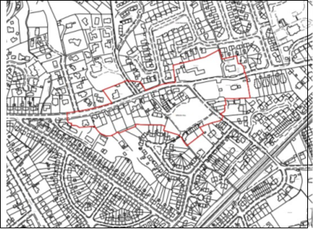
Figure 10. Baildon Station Road Conservation Area
Source: Bradford Council PSGA AC0000823741
D. Saltaire Conservation Area (Roberts Park only)
9.11Roberts Park sits to the south of the Baildon Neighbourhood Area and is the only formal maintained park in Baildon. The southern border of the park is the River Aire.
- In 1971 Saltaire including Roberts Park was designated a Conservation Area.
- In December 2001, Saltaire including Roberts Park was designated as a UNESCO World Heritage Site.
Roberts Park was originally designed and created by Sir Titus Salt as a recreation area for Saltaire and was named after Sir James Roberts (then joint owner/manager of Salts Mill) who gave it to the City of Bradford in 1920. Further details about the heritage features within Roberts Park can be found here: Robert’s Park Historic England Listing (https://historicengland.org.uk/listing/the-list/list-entry/1001226?section=official-list-entry)
The historic footpath Dixon Mill Lane leads from Shipley Glen to Roberts Park and predates the Park – see section on Footpaths and was originally a route for workers at Dixon Mill which was situated across the river on the site of the current New Mill. Sir Titus Salt purchased this mill as preparation for the construction of the model village of Saltaire.
NB. Although Roberts Park is within the Baildon Neighbourhood Area, the park falls within Shipley Ward of Bradford Council rather than the Baildon Ward.
Figure 11. Saltaire World Heritage Site boundary. Roberts Park is on the north (top) of the map.
Source: Bradford Council PSGA AC0000823741
Baildon Policy 13 – Conserving and Enhancing Baildon’s Conservation Areas
New developments in and affecting the setting of the Baildon’s Conservation Areas should be designed sensitively to ensure the special characteristics of these areas are preserved or enhanced.
Planning applications should demonstrate evidence of consideration of the following criteria:
BP13/1 Listed buildings and non-designated heritage assets should be preserved and protected in accordance with their significance.
BP13/2 Appropriate scale, massing and siting of new development, in keeping with the overall character of the Conservation Area in which it is situated or impacts.
BP13/3 Use of natural materials such as traditional local stone for elevations; stone slates for roofing materials; timber for windows, doors and shop fronts. Stone walls or hedgerows should be used for boundary treatments.
BP13/4 Maintaining original building openings and retaining the number, size and proportion of openings on elevations.
BP13/5 Where highway works are proposed, these should seek to minimise adverse impact on the Conservation Area and their traditional character and form of the villages. Depending on the size of development, flexibility in visibility splays, footway requirements and materials usage will be supported where they would retain local character and distinctiveness yet safeguard highway safety.
BP13/6 New surfaces e.g. roads and paving should use traditional materials.
BP13/7 Where signage is used this should avoid clutter.
BP13/8 Adverse impact of a proposal on valued open space within the Conservation Areas, including the Local Green Spaces proposed to be designated in this plan, should be minimised.
BP13/9 Where traditional vernacular architectural detail, such as datestones, ornamentation etc. are still present these should be retained. Where opportunities arise, correct details should be re- introduced to listed buildings.
BP13/10 Traditional shopfronts should be retained or, where necessary, upgraded or replaced with a modern equivalent of traditional design. Where new shopfronts are proposed these should be of traditional design.
BP13/11 Mature and semi- mature trees, hedgerows and stone walls, should be retained where possible.
Baildon Town Council Supporting Actions – Station Road Conservation Area
BTC will:
- Work with key local partners to identify potential changes to the Conservation Areas. The initial priority is to seek review of the Station Road Conservation Area. The Town Council will then request that City of Bradford MDC use their powers to undertake a formal review of the other Conservation Areas.
Background and justification – non-designated heritage assets
9.12Baildon’s many and varied non-designated local heritage assets require protection so that they can continue to contribute to the quality of life in Baildon for generations to come. The list in Baildon Policy 14 below are assets with no current specific protection, despite many being identified within the Conservation Area Appraisals, Assessmentsand West Yorkshire Archaeology Advisory Service Historic Environment Records. Baildon Policy 14 adds value to the Core Strategy by setting out an approach to development at or in the setting of non-designated heritage assets.
9.13Non-designated heritage assets will be submitted by Baildon Town Council for consideration as part of the Government-financed West Yorkshire Pilot Study 2022 that has not yet commenced.
9.14The removal of the Baildon Library and the Town Council offices to temporary accommodation in a former newsagent shop in 2022 allowed for the demolition and disposal of Ian Clough Hall site for development. Since 2022 a range of factors have stalled the development of the site and Baildon is left with a Library Service which cannot provide the range of activities it once delivered.
9.15Bradford Council plans to develop a vacant building in the heart of Baildon – the former Baildon Club but this development has also stalled. The development of this key building in the heart of Baildon is vital a) for its survival b) for the visual impact and integrity of Baildon centre and c) for the continued community vitality of the area.
BTC seeks to identify and develop a space which can be:
- A community-focused flexible library service, including access to online technology and workspace.
- A “cultural hub” with spaces for events, exhibitions, music, and creative activities
For further details see Appendix H.
Baildon Town Council has successfully nominated the Baildon Club as an Asset of Community Value.
Baildon Policy 14 – Protecting Baildon’s Non-designated Heritage Assets
The Policy identifies the following buildings and structures (as shown on the Policies Map) as Baildon Non-designated Heritage Assets
BP14/1 - Padgum
BP14/2 - Lynton House
BP14/3 - 1-3 Northgate (Baildon Club)
BP14/4 - Towngate Rooms
BP14/5 - East Parade
BP14/6 - Village Sweet Shop on Wheels
BP14/7 - Potted Meat Stick
BP14/8 - Sandals Mill
BP14/9 - Tong Park Co-op
BP14/10 - War Memorial, Tong Park
BP14/11- Tong Park School Foundation Stone
BP14/12 - The Baildon/Wharfedale boundary stone
BP14/13 - Kirklands House
BP14/14 - Charlie Thomson's house
BP14/15 - 49 Station Road, Hay Loft
BP14/16 - The Mews, Woodlands
BP14/17 - Baildon Railway Station Building
BP14/18 - Shipley Glen Tramway
BP14/19 - Old Glen House
BP14/20 - Trigonometrical Point (Trig Point) on Baildon Moor
BP14/21 - Trigonometrical Point near The Whitehouse
BP14/22 - Three British Telecom Telephone Boxes
BP14/23 - Old Post boxes
BP14/24 - Providence Row Street Name
BP14/25 - Proposals for refurbishment of the Baildon Club which provides all the facilities for a Cultural hub will be supported.
Development proposals affecting these assets will be supported when they preserve or enhance these assets. Developments that would result in the loss of, or have a significant adverse impact on, these assets will only be supported in the following circumstances:
- Where renovation or alteration of non-designated heritage assets require planning permission, such changes are designed sensitively and with careful regard to the heritage asset’s historical and architectural value and paying appropriate regard to the asset’s setting; or
- Where a development proposal would result in the loss of, or substantial harm to a locally non-designated heritage asset, such development will only be supported when the public benefit of the proposed development outweighs the loss of or harm to the asset and its setting; and
- Where such development is permitted, this will be conditioned in such a way as to ensure the proposed development takes place after the loss or harm has occurred (e.g. demolition or removal of a building feature); and that appropriate recording of the heritage takes place prior to any loss or harm.
Baildon Town Council Supporting Actions – Non-Designated Heritage Assets
- BTC seeks to work with community groups to develop interpretation features which enhance knowledge and understanding of the history of Baildon.
Background and justification – Shipley Glen Tramway
9.16Shipley Glen Tramway is one of the most important heritage assets in Baildon. Opened in 1895 the Shipley Glen Tramway is an historic funicular tramway situated in the attractive Shipley Glen (https://visitbaildon.co.uk/shipley-glen/) near the village of Saltaire (https://visitbaildon.co.uk/saltaire-and-salts-mill/). The lower station of the funicular is close to Roberts Park on the border of Saltaire World Heritage site and part of the immediate WHS buffer zone. The Old Glen House public house is in the setting of the upper station and is protected elsewhere in this Plan. The tramway line is operated today by volunteer staff on behalf of a charitable trust, Shipley Glen Tramway Preservation Co Ltd.
The line was opened on 18 May 1895 by Sam Wilson, a local publican, showman and entrepreneur. It was intended to ease access to a number of other, now long closed, attractions at Shipley Glen, including a wooden toboggan ride and a massive fairground, a camera obscura, a children’s aerial glide and a nearby Japanese Garden and children’s boats.
In Victorian times people from Bradford used to catch the tram to Saltaire, walk down Victoria Road, over the then existing road bridge and up to Bracken Hall, Baildon Moor and over to Ilkley. Today the Tramway together with the footpath alongside the Tramway (Dixon Mill Lane) provides an important and well used pedestrian route for children attending Titus Salt School and many who (as in the past) are walking to their place of work or Saltaire Station.
Originally powered by a gas engine, since 1928 the line has been electrically operated. The tramway was closed in 2010, to bring it up to modern safety standards. This involved fitting the two tramcars with new chassis, wheels and decks, and improving braking systems on both cars and haulage drum and CCTV communication between both stations. The line reopened in 2011; the work having been done by the Bradford Trolley Bus Association. It was then run commercially until later taken over by a Trust.
9.17Shipley Glen Tramway comprises:
- Shipley Glen Tramway buildings
- The setting of and approach to this important asset, both landscape and buildings (upper and lower approaches – See Appendix D Green Spaces
- The track itself
- The woods either side of the track (woodland setting- See Appendix D Green Spaces)
- The footpath/bridleway alongside the Tramway – Dixon Mill Lane
Baildon Policy 15 – Shipley Glen Tramway
The Shipley Glen Tramway (as shown on the Policies Map) will be protected as key non-designated heritage asset for the neighbourhood area. This includes protecting:
BP15/1 - The existing buildings associated with the Tramway (including the upper and lower stations), the track and the adjacent footpath (Dixon Mill Lane).
BP15/2 - Woodlands and greenspaces (as shown on the Policies Map along the route of the track).
BP15/3 - Proposals adjacent or close to the upper and lower approaches to the tramway will only be supported where the proposal:
- Improves access to tramway for users and visitors.
- Improves the visual amenity of the area including the preserving or enhancing of the visibility of the Tramway entrance at both the top and bottom.
- Designs enhancements that are sympathetic to heritage of the tramway and the surrounding area.
- Is consistent with the Baildon Design Guidance and Design Code as well as policies within the neighbourhood plan and Bradford District local plan relating to design.
Consequently, any proposals for adjacent development which obscures sightlines to the upper or lower entrances will not be supported.
Background and justification – Design Codes
9.18National planning policy states that planning and development should seek to achieve “the creation of high quality, beautiful and sustainable buildings and places” and that “Good design is a key aspect of sustainable development, creates better places in which to live and work and helps make development acceptable to communities” (NPPF, Paragraph 131). The NPPF (Paragraph 139) is also clear that development that is not well designed should be refused, particularly where it fails to reflect local design policies and government guidance. The Bradford Core Strategy and emerging Local Plan also include detailed policies that seek to achieve good design.
Policy 16 seeks to help to deliver this national and local planning policy by setting out the design expectations for Baildon. The Policy aims to achieve this by ensuring development is designed in such a way that it takes account of national and strategic planning policy and specific Baildon features in a Baildon context.
To achieve this and sitting alongside the NP the Baildon Design Guidance and Codes 2024 (AECOM) has been prepared. As it is a very long document two extracts have been prepared Appendix B.1 which is an abridged version and Appendix B.2 which is a Design Codes Checklist for developers and householders.
9.19New housing development in Baildon will necessarily be limited due to the extensive and intensive housing developments over the past century, the lack of available and suitable sites together with the modest housing targets. This policy area covers the developments which do happen in Baildon together with alterations to existing properties.
9.20The Baildon Design Guidance and Codes 2024 are based on a thorough analysis by external consultants of the townscape character of the area and sets out detailed design guidance based on 8-character areas which have been defined within the Code. These areas are not necessarily co-terminus with the neighbourhoods as understood locally.
9.21Planning proposals should be designed with a comprehensive analysis of the place to understand the proposal’s broader context and establish a place-specific response to the location and character area within which it is situated. This should be done by responding to the detailed design guidelines for the relevant Townscape Character area included within the Baildon Design Guidance and Codes 2024.
9.22In addition, Baildon Design Guidance and Codes 2024 includes more detailed Design Codes for those preparing proposals for new housing development. The Codes set out expectations a range of themes that planning applications for new housing development will be expected to address, for example:
- Preserving local architectural features
- Having regard to historic street grid and layouts
- Valuing local green spaces, views and character, sense of place
- Gateway and access features
- Using historic building layout and groups
- Respecting building line and boundary treatments and maintain character such as stone walls.
- Having regard to building heights and rooflines
- Using/re-using original building materials and treatments
- Appreciating impact on local and long views
- Innovation in sustainability
9.23One of the most notable features of the Baildon landscape is the widespread survival of old stone boundary walls. These can be seen all over Baildon, examples include Baildon Road, Station Road, Jenny Lane area. It is important to preserve the character of Baildon and any proposals to replace such features with modern equivalents such as fencing or modern bricks is not permitted.
9.24Policy 16 does not seek to stifle innovation or produce pastiche copies of the past. Innovation and contemporary design are encouraged, but here, as with all new developments, applicants and their architects should draw on the past to inform their proposals to ensure that new development is in keeping and harmonises with that of the past.
9.25As well as meeting the design guidance for the Village Centre character area, those preparing planning proposals that include a shopfront(s) should also ensure that the shopfront(s) are designed to be consistent with guidance adopted in March 2026 in the Bradford Council Shopfront Design Guide (https://www.bradford.gov.uk/planning-and-building-control/planning-policy/shopfront-design-guide-supplementary-planning-document/.
Baildon Policy 16 – Baildon Design Guidance and Codes
The following measures will be supported:
BP16/1 The design of any new developments should be informed by the Baildon Design Guidance and Codes 2024 Appendix B. Whilst there may not be substantial new developments, any adaptations/extensions and improvements to existing property will be expected to adhere to the Design Codes.
BP16/2 All new developments will be expected to respond positively to the key attributes of the neighbourhood area and the Townscape Character area (as defined in the Baildon Design Guidance and Codes 2024) within which it sits.
BP16/3 Any proposals to replace stone boundary walls with modern equivalents such as fencing or modern bricks will not be supported.
BP16/4 Proposals for new housing development should also demonstrate how they have considered and addressed, where appropriate the Design Code’s guidance on context, identity, form, boundary treatment, movement, nature, public spaces and sustainability.
BP16/5 For all proposals, applicants will be expected to demonstrate how a development proposal has taken account of, and been designed to incorporate, the recommended Design Code elements. This does not preclude innovative or contemporary design, where such design can be shown to respond to and provide a contemporary design solution that complements and reinforces local character.
BP16/6 Proposals will not be supported when they are of poor design when considered against Bradford’s local planning policy and guidance, national policy and local guidance on design.
Linked Policies Summary
National Planning Policy Framework NPPF, Paragraph 131 and 139
Bradford Council Core Strategy Policy EN3
Shop Front Design Guide SPD March 2026
