

Baildon Neighbourhood Plan (2026-2040)
8.0 Objective 3 - Environment and Countryside
To protect and enhance the countryside, local green spaces and the natural environment.
Background and justification – Countryside (Landscape)
8.1There is a substantial evidence base to support landscape-based planning policy for Baildon. At the national level – Natural England’s National Character Areas (NCAs) and at the local level - Bradford Council’s Core Strategy and their Adopted Landscape Character Supplementary Planning Document March 2026.
8.2The landscape is, in part, a product of human activity, some of which should be preserved for its heritage and archaeological significance. Other features of human activity, such as Baildon Reservoir, raise other issues in terms of landscape impact, maintenance and contamination.
8.3Baildon Town Council will work with Bradford Council/West Yorkshire Combined Authority‘s emerging Local Nature Recovery Strategy.
8.4NCA profiles are guidance documents which support the planning of conservation initiatives at a landscape scale, inform the delivery of Nature Improvement Areas and encourage broader partnership working through Local Nature Partnerships. The profiles will also help to inform choices about how land is managed and can change. Baildon straddles two NCAs:
- NCA36 Southern Pennines
- NCA37 Yorkshire Southern Pennine Fringe
Details on NCA36 and NCA37 as they relate to the Baildon Neighbourhood Area can be found here:
Natural England’s NationalCharacterArea South Pennines (https://nationalcharacterareas.co.uk/southern-pennines/)
Natural England’s NationalCharacterArea Yorkshire Southern Pennine Fringe (https://nationalcharacterareas.co.uk/yorkshire-southern-pennine-fringe/)
8.5Bradford Council’s Core Strategy Policy AD1 sets out that the landscape character of the Pennine Uplands and upland fringe areas of Airedale will be protected and enhanced; green infrastructure will be improved along the Airedale river, canal and public transport corridors; and river, beck and canal corridors will be protected and enhanced for their biodiversity and heritage value potential for reducing flood risk and role in improving connectivity between urban and rural areas.
8.6Bradford Council’s newly adopted landscape character supplementary planning document (SPD) can be found here: Bradford Council’slandscapecharactersupplementary planning documents (https://www.bradford.gov.uk/planning-and-building-control/planning-policy/landscape-character-assessment-supplementary-planning-document/). This provides an existing and detailed statement of the landscape of the Bradford District, identifying its distinctive attributes and features which are desirable to preserve and enhance and, crucially, the conservation and land management strategies.
The District is divided up into 8 Landscape Types and Baildon Parish falls within a number of Landscape Types (see Figure 7 below). Baildon includes the southernmost tip of the Rombalds Ridge and in Baildon this comprises the gritstone moorland of Baildon Moor and the areas of mixed upland pasture that fringe this area to the south and then extend into the Esholt.
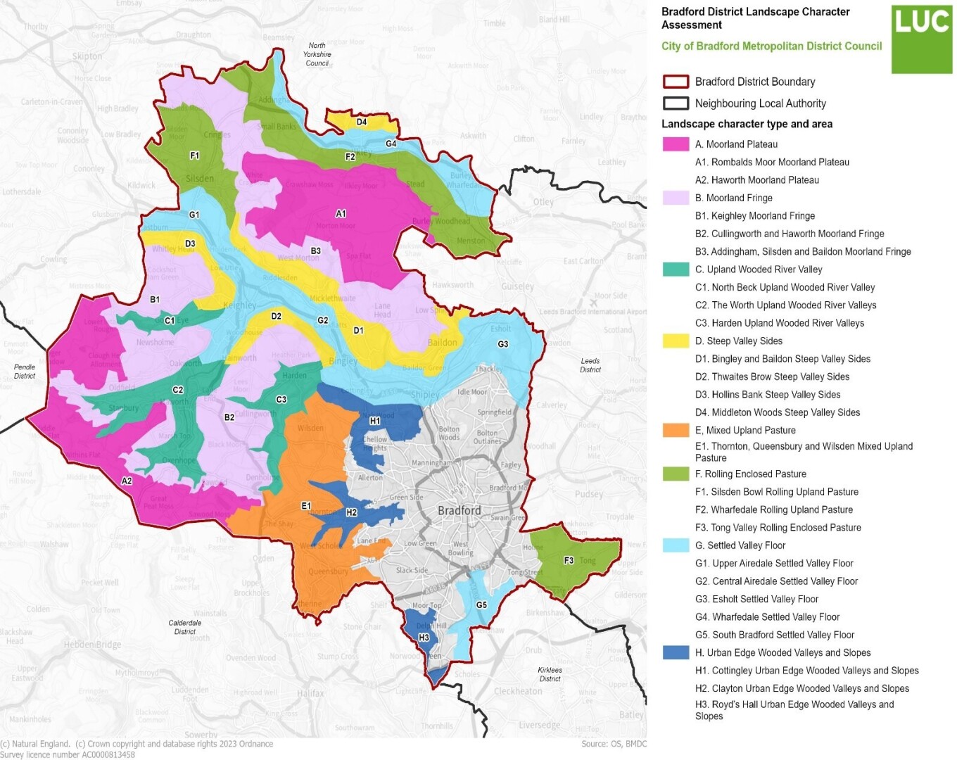
Figure7.Landscape Types
A. Bradford Pennine Gateway National Nature Reserve
8.7On 13th May 2025 the Bradford Pennine Gateway, one of the new King’s Series of National Nature Reserves (NNR) was created. The reserve encompasses 1,274 hectares, with 738 hectares (58%) designated as Site of Special Scientific Interest (SSSI). Approximately 90% of the area comprises UK priority habitats, including peat bogs, heathlands, and wetlands. Over 70 Biodiversity Action Plan species have been recorded, including curlew, golden plover, short eared owls, and adders, underscoring the reserve’s ecological significance. The component sites in the NNR include Ilkley Moor, Baildon Moor, Shipley Glen, Trench Meadows, St Ives Estate, Harden Moor, Bingley Bog North, and Penistone Country Park. Bringing these sites together under the banner of one NNR will aid nature recovery across and beyond these sites.
This NNR will facilitate a landscape management approach for these sites and the wider area. Enhanced nature across the NNR sites (and the wider network) will provide bigger, better and more joined up nature across the district. The reserve will also enhance educational and cultural opportunities in the area. In collaboration with local universities and colleges, the reserve will offer opportunities for field studies and research.
B. Baildon Moor
8.8Baildon sits at the edge of Baildon Moor surrounded on 3 sides by open countryside (mostly protected Green Belt) and bounded by the River Aire and the Leeds Liverpool Canal, all of which give Baildon a characteristic landscape. This landscape can be viewed from most parts of Baildon, and its preservation is important to residents.
Baildon Moor reaches a height of 282 metres and is a conical hill north of Baildon centre. The moor is part of Rombalds Moor, with several quarries and underlying strata of coal. There are the remains of old bell pits for mining the coal. There are other archaeological remains from Bronze Age cup and ring stones to World War Two defence structures. Baildon Moor and the countryside to the north, east and west of the settlement contain a number of biodiversity designations such as Local Wildlife Sites (LWS)–Baildon Bank, Baildon Moor; Fairbank Wood; Shipley Glen; Tong Park with Hawksworth Spring Wood; and Shipley Glen-and Local Geological Sites (LGS)–Baildon Bank & Baildon Green Quarries; Baildon Moor; and Shipley Glen. The Trench Meadows Site of Special Scientific Interest (SSSI) is adjacent to the southwestern edge of the built-up area. There are also several areas of ancient woodland-Fairbank Wood and Walker/Midgeley Woods–within and adjacent to the settlement. The vast majority of Baildon falls within 7km of the South Pennine Moors (Phase 2) SPA and SAC (and SSSI).
Baildon Moor has great significance to the community for a myriad of recreational and sporting activities, mental wellbeing and sense of place and community identity.
C. Baildon Reservoir site
8.9This historic site occupies a very prominent position on Baildon Moor. In 2023 this important location was re-possessed by Bradford council as freeholder.
8.10The Baildon reservoir site sits within the wider Baildon Moor and presents an opportunity to secure a range of benefits through a nature recovery approach to its remediation, including the creation of an important wetland habitat, thus contributing to the reduction of carbon emissions. Such a habitat could contribute towards overall objectives for the local moorland assets managed by Bradford Council and would provide a range of benefits: wetland restoration to encourage peatland and active blanket bog, increased biodiversity, increased resilience to wildfire and local flood mitigation, and increased carbon capture and storage – thus reducing harmful greenhouse gases.
It is hoped that a newly created wetland habitat including sympathetic management of the existing watercourse, together with planting and re-seeding of moorland/wetland species, would achieve many benefits and be a long-term asset for the Moor and the people of Baildon. ‘Re-wilding’ a site such as this takes time.
8.11Initial specialist surveys and ground investigations have been completed (2024). Further assessment will be needed before any plans can be developed. The site has been used in the past for extensive illegal tipping of low-level waste, and it is important to address this “land remediation” first in any plans. Restoration of the site is a complex process and can be expected to be at least a three-year project, if not longer, with the following essential elements requiring resolution before such a project can be delivered: -
- Careful analysis of the ground investigation data and full options appraisal of options for remediation
- Proposal for treatment or removal of the boundary walls and other ‘hard’ features
- Common land and other legal issues
- Planning consent
- A detailed proposal which incorporates all the above
- Funding sources to undertake the work and deliver the project.
Baildon Policy 8 – Baildon Reservoir Site
The following measures will be supported:
BP8/1 The creation of a wetland habitat at Baildon Reservoir that contributes toward protecting and enhances the biodiversity of the neighbourhood area will be supported. Proposals should have regard to the habitat network and landscape character of the surrounding area.
BP8/2 Development proposals should demonstrate how they have had regard to the details of the landscape characteristics set out within the Landscape Character Supplementary Planning Document March 2026.
Town Council Supporting Actions – Baildon Reservoir Site
BTC will:
- Work with Bradford Council and other key stakeholders to bring forward the creation of a wetland habitat at the former Baildon Reservoir.
D. Bracken Hall Countryside Centre and Bracken Hall Green
8.12Bracken Hall Countryside Centre is located on the edge of Baildon Moor, close to Shipley Glen. The flat area directly opposite the Centre is known as ‘Bracken Hall Green’ and this also marks the start of the Millennium Way – a series of walks throughout the whole Bradford District. The Centre acts as a ‘gateway’ to rambles on the Moor, down into the Glen and along to the Shipley Glen Tramway.
Around 4.000 visitors a year are encouraged to investigate, explore and connect to the local natural history, archaeology and social history of the Glen and the Moor through displays, themed activities and a wildlife garden. There is a year-round, seasonal programme of guided and self-guided walks, workshops, events and sessions with specialists to engage visitors and interpret the countryside. The Centre also facilitates educational visits for all age groups and hosts a number of local community groups.
8.13Bracken Hall Countryside Centre is a focal point for the Bradford Pennine Gateway NNR developments and Baildon Town Council is keen to maximise the opportunities this initiative presents for the people of Baildon. The Centre is held on a 20-year lease by the Town Council (at the time of writing it has 8 years and 7 months to run), and its ongoing protection, conservation and improvement is a priority for Baildon Town Council.
Baildon Policy 9 – Conserving and Enhancing the Landscape
The following measures will be supported:
BP9/1 Maintaining and enhancing the landscape setting, landscape features, field and settlement pattern of the neighbourhood area.
BP9/2 In upland areas development should avoid skyline development and preserve long distance views.
BP9/3 Seeking to preserve in situ assets of heritage and archaeological value.
BP9/4 Preserving, restoring and reclaiming human made features of the landscape
BP9/5 Retaining or enhancing the biodiversity of ponds, streams, mature trees, woodland and hedgerows. Or where removal is unavoidable, providing, by way of offsetting, replacement equally biodiverse habitat elsewhere on-the site or within the neighbourhood plan area.
BP9/6 Where new planting and landscaping is proposed, it should use native species and be designed in such a way to ensure that it is suitable when considered in the wider local landscape and its biodiversity, and where appropriate, links to existing woodland and hedgerows.
BP9/7 Seeking to minimise the encroachment of development into visually exposed landscapes and where development is proposed on the edge of the settlement, it enhances views of the settlement edge from the surrounding countryside and does not lead to inappropriate incursion into the surrounding countryside because of its siting, design, materials or use of landscaping.
BP9/8 Maintaining and improving access to the surrounding countryside (Baildon Moor, Shipley Glen, Gill Beck (Tong Park)) in ways that do not lead to significant detrimental impacts on the landscape and biodiversity because of increased recreational visits and activities.
BP9/9 Development proposals should demonstrate how they have had regard to the details of the landscape characteristics set out within the Landscape Character Supplementary Planning Document (SPD) March 2026.
BP9/10 Should any existing uses on Moorland cease ( e.g. caravan parks, former reservoir) it is essential that these sites revert to green belt designation ie are not classed as brownfield sites.
Town Council Supporting Actions – Conserving and enhancing the Landscape.
BTC will:
- Following the NNR declaration, Bradford Council, Natural England and Baildon Town Council will work together in partnership to create a strategic management plan which would better inform the existing site-based plans and set them in a wider and more ambitious context.
E. Enhancing the natural environment of the River Aire corridor
8.14Baildon Policy 10 seeks to provide additional detailed planning policy and guidance for the River Aire corridor and picks up on the strategic policy for Airedale set in Core Strategy Policy AD1 (Section C point 3 and 4) that seeks to protect and enhance river corridors for their biodiversity and heritage value, potential for reducing flood risk, and role in improving connectivity between urban and rural areas.
8.15The River Aire corridor has an important functional role in flood risk management and climate change adaptation.
8.16The River Aire runs through the valley in the south of Baildon, its resources were used extensively by the Textile Mills that lined the river from 1780 onwards. As the mills closed the riverside area was converted to different employment uses and is currently used predominantly for a diverse range of employment purposes.
8.17The Denso Marston nature reserve is adjacent to the river Aire but the riverside path (other than the area of the reserve) is treacherous in places which limits public access.
8.18The Airedale Way passes through Baildon alongside the River Aire, between Baildon Bridge and Esholt Lane.
8.19The Baildon NP can only set planning policy within the Baildon Neighbourhood Plan Area. However, the Neighbourhood Area boundary is, in part, formed by the River Aire and so to achieve effective implementation of this Policy will involve partnership working with key agencies and, if possible, similar planning policy to be put in place in neighbouring areas.
Baildon Policy 10 – The River Aire Corridor
Development in the River Aire Corridor (as shown on the Policies Map) will be supported where it:
BP10/1 Retains existing riverside access and routes and, where appropriate, creates safe new routes and access points. This includes enhancing the Airedale Way long distance path.
BP10/2 Protects existing areas of open space and recreational facilities as identified in Local Green Spaces Policy.
BP10/3 Protects and/or enhances the corridor’s natural environment and built heritage.
BP10/4 Improves and extends green infrastructure networks within the corridor and extends them to and from surrounding areas.
BP10/5 Whilst the Sequential Test or the Bradford Strategic Flood Risk Assessment (SFRA) is implemented by Bradford Council, BTC would wish to see due consideration of this in all development proposals.
Baildon Town Council Supporting Actions - River Aire Corridor.
BTC will:
- Work with other authorities including Bradford Council (who implement the Water Framework Directive) to protect and enhance the River Aire corridor both within and beyond the neighbourhood area (Shipley and Esholt).
- Flood response is a national policy issue, but BTC will work with other partners on Emergency Response to flooding risk.
F. Views and Vistas
8.20Baildon’s topography makes for stunning and panoramic views within Baildon, back into Baildon from adjoining settlements and out of Baildon – sometimes as far as Leeds and Kirklees. The views are a major part of what makes Baildon a special place for residents and visitors alike – with outstanding walks and the multiple benefits this brings for physical and mental health and the visitor economy. It is considered that these views, in particular those of Baildon, should be safeguarded from development that would detract from their visual qualities and landscape setting of the neighbourhood area. Inappropriate development may include: high-rise buildings, poorly designed structures, buildings which use materials which might be too prominent in the view (due to size, form, density and massing) or detract the eye due to inappropriate materials, buildings which damage the setting of listed buildings and non-designated heritage assets by their incongruous position in the view and structures which diminish and detract from the understanding of the history of the natural landscape.
Baildon Policy 11 – Views and Vistas
1The views and vistas (listed below and the Policies Map) contribute to the character of the neighbourhood area:
- BP11/1 - Viewpoint 1: The entrance to the Parish Church
- BP11/2 - Viewpoint 2: The path along the top of Baildon Bank
- BP11/3 - Viewpoint 3: From the northern boundary of the Tong Park & Esholt Cricket Club
- BP11/4 - Viewpoint 4: From the Tong Park War Memorial
- BP11/5 - Viewpoint 5: From the Moor looking East
- BP11/6 - Viewpoint 6: From the Moor looking South
- BP11/7 - Viewpoint 7: From the Moor looking West
- BP11/8 - Viewpoint 8: Looking South from Green Lane.
2Proposals should preserve or enhance the wider landscape character of the neighbourhood through their design, scale, height, massing and use of materials and should clearly recognize and respond to these views and vistas. Where appropriate. a Landscape and Visual Impact Assessment will be required.
3Proposals that would have a significant adverse impact on an identified view and vista (and also including the view of the Saltaire World Heritage Site in BP11/8) will not be supported.
4Development in Baildon which causes harm to the Designated Views from the Saltaire World Heritage Site see saltaire-world-heritage-site-management-plan2014-v2.pdf Appendix 7.1 will not be supported.
Background and justification – Green Spaces
8.21One of the key priorities identified through earlier consultation and engagement has been the need to protect and enhance Baildon’s green spaces. This was also a top priority identified in the preparation of the Baildon Plan 2019 Update. By designating Local Green Spaces, a national planning policy protection, Baildon seeks to protect our green spaces in the same way as Green Belt (National Planning Policy Framework (NPPF) paragraph 108).
8.22Paragraph 106 of the NPPF allows local communities, through neighbourhood plans, to protect green areas of particular importance to them by designating Local Green Space. Protecting and enhancing green spaces was one of the top 4 priorities identified for the area in the Baildon Plan Update 2019.
8.23Paragraph 107 of the NPPF goes on to advise that “the Local Green Space designation should only be used where the green space is:
- “in reasonably closeproximityto the community it serves.
- demonstrably special to a local community and holds a particular local significance, for example because of its beauty, historic significance, recreational value (including as a playing field), tranquility or richness of its wildlife; and
- localincharacterand is not an extensive tract of land.”
8.24Green spaces can sometimes be smaller, often quite incidental green spaces that help to make the area a greener place, and they add to the quality of life enjoyed by residents and visitors.
8.25The Baildon NP also seeks to encourage enhancements to these green spaces when suitable opportunities and funding arise. This may include changes to enhance recreational use. Development proposals with the Local Green Spaces will be consistent with national planning policy for Green Belts. Development that would result in the loss of green spaces identified on the Policies Map within the neighbourhood area will only be supported when equivalent or better provision is provided elsewhere within the Baildon neighbourhood area; or it can be clearly demonstrated by the applicant that the open space no longer performs a useful open space function in terms of the local environment, amenity, or active public recreation use.
8.26Several open spaces in the Baildon Neighbourhood Area have been assessed to see if they meet the designation criteria set out in national planning policy (see Appendix D). Although some of these open spaces are protected by other designations (e.g. Green Belt), they are listed in our Policy in case these other designations should change during the timespan of this Plan.
8.27There are local green spaces such as Midgeley Wood and Walker Wood which have been excluded purely because of their size ie. they are defined as ‘extensive’. However, they are valuable to the local community.
Roberts Park
8.28This historic park which sits to the south of Baildon NA alongside the River Aire, is the only formal maintained Park within Baildon. The park is an integral part of both the Baildon and Saltaire communities and often is used for events that bring people together across the district, such as bandstand performances, Shakespeare in the park, part of Saltaire Festival, Dragon boat races, cricket pitch, and more.
This very well used park is protected as Grade 2 in English Heritage Register of Parks and Gardens and is a Green Flag award winner. The park is full of charm, with a long promenade, many historic features, a bustling café, beautiful bandstand and a multi feature play area and skate park.
The Friends of Roberts Park work with Bradford Council to improve the park and activities held there. It is the most well used green space in Baildon.
Baildon Policy 12 – Protecting Local Green Spaces
The following areas, listed below and shown on the Policies Map, are designated as Local Green Space in accordance with Paragraphs 105 and 106 of the National Planning Policy Framework see Appendix D:
BP12/1 – Jenny Lane Fields
BP12/2 – Pennithorne Common
BP12/3 - Baildon Community Garden, Hall Cliffe
BP12/4 - Kellcliffe
BP12/5 – Bartle Gill Green
BP12/6 – Gill Beck Valley and Spring Woods
BP12/7 – Fennec Road and Halliway Banks Wood
BP12/8 – Charlestown Cemetery
BP12/9 – Hoyle Court Green
BP12/10 – Small Green spaces in Charlestown Junction Ada Street/Fyfe Lane
BP12/11 – War Memorial Garden (Browgate)
BP12/12 – Pocket park at junction of Netherhall Road/Station Road
BP12/13 – Woodbottom Gardens (Woodcot Avenue)
BP12/14 - Brook Hill Green
BP12/15 – Denso Marston Nature Reserve
BP12/16 – Temple Rhydding Drive
BP12/17 – Fairbank Wood and the Knoll
BP12/18 – Cliffe Avenue Recreation ground/Peace Garden
BP12/19 – Ferniehurst Dell
BP12/20 – Shipley Glen, Bracken Hall Green, Glen Woods and Crag Hebble Dam
(already protected as designated Green Belt)
BP12/21 – The rural Setting immediately adjacent to Shipley Glen Tramway
BP12/22 – Shipley Glen Tramway setting and immediate upper approaches.
BP12/23 – Shipley Glen Tramway setting and immediate lower approaches (includes Thompson Lane Fields)
Linked Policies Summary
Bradford Council’s Core Strategy Policy AD1
Green Belt (National Planning Policy Framework (NPPF) paragraph 108
