

Bradford District Local Plan - Publication Draft (Regulation 19) (October 2026)
Section 2: Plan Introduction Comment
2.1 Plan Directions
Delivering Sustainable Development
2.1.1Planning involves making decisions about the future of our cities, towns, villages and countryside – where we work, live, and spend leisure time and how we are able to get to these destinations. It involves ensuring that services, utilities and infrastructure are available where they are needed and attempts to balance different needs and goals – supporting development, growth and regeneration but also protecting, conserving and enhancing our built and natural environment. We need to achieve a strategy for sustainable development that meets the needs of the present without compromising the ability of future generations to meet their own needs.
2.1.2Plan-making also involves the process of building evidence, combining research and analysis with engagement and consultation with all who have a stake in making our District a great place and in the process producing a framework of policies and proposals to guide future decisions on where development will take place and in what form. Plan-making also involves making clear decisions about a spatial strategy and locations for new homes, employment and other uses as well as areas and important assets we want to protect and enhance. Ultimately, plan making is aimed at creating sustainable and vibrant communities and places.
2.1.3The Local Plan sets out how the Council will take a balanced approach to growth – protecting and retaining our natural and built assets but with a clear focus upon meeting our acute housing need for 33,669 new homes by 2043 and employment land need of 110.5ha over the plan period. This will be delivered via a mixture of brownfield urban regeneration, development within settlements and sensitive sustainable site developments on the edge of settlements.
2.1.4Taking a brownfield first approach, the plan concentrates on maximising growth on non-greenfield sites while not leading to over development and the loss of facilities and important urban green and open spaces.
2.1.5Councils are legally mandated to prepare a Local Plan that sets out the vision, spatial strategy and policies for the future development and use of land in their administrative areas.
2.1.6The Local Plan forms part of the overall statutory development plan for the Bradford District alongside adopted Neighbourhood Development Plans. The importance and role of Neighbourhood Plans is recognised and relationships with sites and policy areas in the Local Plan is identified where relevant.
Unlocking Urban Growth and Regeneration
2.1.7The Regional City of Bradford is at the cusp of transformational physical change with significant investment targeted for enhancing connectivity through public transport improvements including a new city centre railway station and mass transit network which has stimulated further rethinking about the role of the city centre and its huge potential for economic growth, new neighbourhoods, public realm and green space improvements, new services and facilities, and places to live. Building upon investment in housing and commercial space through City Village and One City Park and the physical redesign of the city core through Norfork Gardens and public space and active travel routes, physical transformation and the regeneration of the city centre are a central pillar in the Local Plan.
2.1.8The Local Plan includes the extension of the city centre and nine city centre regeneration areas with a clear focus upon targeted economic growth and housing – 10,000 new homes within the plan period and an increase in resident population by over 20,000. This will entail radically diversifying our urban housing offer to deliver different types of homes – townhouses, terraces, duplex schemes, apartments and senior living.
2.1.9The Southern Gateway Regeneration Area features one of the largest regeneration sites (126ha) in the country and presents a unique opportunity through a masterplan-led approach for investment and a step change in the scale and extent of physical change possibilities for a regional growth city.
2.1.10The Local Plan remains committed to supporting the economic, physical and social regeneration of the wider Regional City of Bradford and its diverse neighbourhoods. These include Shipley and Canal Road Corridor; inner city areas of Manningham and Little Horton; North-East Bradford – Ravenscliffe and Thorpe Edge; East Bradford – Barkerend, Beech Grove, Bradford Moor, Thornbury, Woodhall and Laisterdyke; South-East Bradford – Bierley and Holme Wood; South-West Bradford – Buttershaw and Woodside and West Bradford – Allerton.
2.1.11Shipley within the north of the Regional City has opportunities to carefully balance its gateway location to Saltaire and Airedale with further redevelopment potential within its defined Regeneration Area and town centre – better connecting its rail station and maximising opportunities for housing and economic growth in a well-connected strategic location.
2.1.12The Holme Wood estate is an important Regeneration Area priority within Bradford South-East – there is a need to integrate new investment in housing to support, retain and improve local services, facilities and connect employment opportunities through a coordinated approach to estate renewal.
2.1.13Within the Airedale corridor Keighley continues to be identified as a key growth location. The Local Plan proposes a wide portfolio of housing development opportunities and continues to support the town’s economic ambitions. A further Regeneration Area has been identified for longer range housing and economic growth – focused on the transformation of the town centre and connected neighbourhoods.
2.1.14The importance of the District’s history, heritage and varied cultures plays a significant role in the plan recognising that the adaptive reuse of historic mill buildings can transform vacant and derelict sites into new neighbourhoods and communities through the lifetime of the plan.
2.1.15Land is a finite resource, and the plan includes clear policy directions to ensure development density is appropriately scaled up in consideration of proximity to services, rail stations and public transport corridors while also being sensitive to existing environments and the need to provide quality design with supporting infrastructure.
A Balanced Approach to Growth
2.1.16The Local Plan is District-wide in scope. It focuses upon coordinated and holistic spatial planning within all our sustainable settlements and applies a sensitive and measured approach to growth. The Plan recognises the District’s unique natural and heritage features, the characteristics of its varied towns and villages, the rich landscapes, together with the diversity of its communities and local needs. This is reflected in the settlement hierarchy and settlement policies for each settlement.
2.1.17To meet our housing and employment needs in full the Local Plan includes the release of Green Belt land around the edge of settlements in sustainable locations as set out in Section 5 of the plan and in alignment with the Framework and plan policy. The Local Plan also takes a fine-grained approach to the development of a masterplan-led Sustainable Urban Extension (SUE) to the east of Holme Wood.
2.1.18The approach to providing new homes recognises the varied range of housing needs across the District – including a focus upon delivery, density, affordable housing, the mix and types of housing, specialist housing and accommodation, including Gypsy and Traveller needs, self-build, plus adaptability and design standards with a clear view on the future within a changing and also ageing society.
2.1.19The Local Plan recognises the importance of meeting our economic needs through a range of employment allocations of different scales and types to attractive investment. The plan also supports indigenous business growth alongside the protection and intensification of Employment Zones across many parts of the District. Employment and economic growth can take many forms, and the Local Plan provides flexibility and a positive policy environment to support our core economic sectors plus new and emerging growth areas, tourism and culture related enterprises - all underpinned by support for skills, education and learning providers ensuring economic growth is locally embedded.
2.1.20The city centre, town centres and myriad of District and local centres continue to play an important but evolving role as the heart of many communities and the location for retail and town centre-type uses. The Local Plan continues to support this focus but recognises strategies need to be adaptable and flexible to maintain the vibrancy and viability of many centres. The over proliferation and clustering of some types of uses which can have a negative impact on health outcomes is also addressed in the plan through policy and assessment.
2.1.21Transport and land use planning are highly inter-connected, and the plan includes a clear focus upon ensuring high density development is maximised near public transport hubs and sustainable transport corridors. The continued transformation of the District’s transport infrastructure network is central to developing healthy places, reducing air pollution and ensuring people and business are better connected and able to access more sustainable transport modes including walking, cycling and public transport. New investment in rail and transit infrastructure is anchored within the plan as key infrastructure priorities.
2.1.22With a changing climate having everyday impacts on the natural environment and local communities, it is essential that the Local Plan anchors a series of key policy directions on air quality environmental protection, renewable and low carbon energy and effective flood risk and water management. A greener Bradford is also good for business – supporting growth in new technologies and economic sectors.
2.1.23The Local Infrastructure Plan (LIP) sits alongside the Local Plan and helps identify gaps in infrastructure provision such as schools, health, transport, sport facilities and critical utilities infrastructure to support housing and economic growth. The LIP is a live document and has informed key policies, information relating to settlements and site allocations. The plan focus is the delivery of the right infrastructure at the right time. Development proposals will, subject to viability, be expected to contribute towards the cost of providing infrastructure and of meeting social and environmental requirements to mitigate against impacts.
2.1.24Effective minerals and waste planning is central to ensuring that Bradford plans for a sufficient and sustainable supply of minerals and while working with partners and neighbouring authorities integrates strategies for waste management in Bradford and a wider sub-regional and regional levels.
Quality of Place and Good Design
2.1.25The Local Plan makes references to a series of long-term transformational development frameworks for the vision and strategic direction of parts of the Regional City, Bingley, Shipley and Keighley. This has helped inform a place-based approach to regeneration areas in a number of locations.
2.1.26Taking direction from the Homes and Neighbourhoods: A Guide to Designing in Bradford (SPD) and work on design coding for the District[1], the Local Plan includes clear intent to raise the bar in design quality. This includes a developed approach to design processes and engagement, landscape design, understanding urban character and form, better street design and parking and embedding design code considerations within plan detail.
2.1.27The District features an extraordinary and deeply varied natural environment with local wildlife, geological and nature reserve sites, SSSIs, a national nature reserve and the internationally important South Pennine Moors Special Protection Area and Special Area of Conservation. Understandably the natural environment is subject to significant policy protection within the plan, which also extends more generally into the importance of green and blue infrastructure planning.
2.1.28Protecting our environmental resources and requiring new development to leave biodiversity in a measurably better state than beforehand will contribute towards mitigating impacts in some of our most valuable landscape and habitat areas and minimise impact on heritage assets.
2.1.29The character and setting of settlements in the District have also been informed by the wider landscape, valley environments with rivers and watercourses and the historic pattern of development over many generations. Through taking a sequential approach to flood risk and balancing settlement character, form and heritage considerations, the Local Plan takes a sensitive approach to the extension of settlement boundaries.
Plan in Numbers
2.1.30Box 2.1 provides some key headlines within this Local Plan.
Box 2.1 – Local Plan in Numbers
- 18-year plan with a minimum of 33,669 new homes from 2025-2043
- A target of 759 new affordable homes per annum.
- At least 110.5 ha of new employment land
- In the region of 30,000 jobs over the plan period.
- 253 housing sites
- Green Belt accounts for circa 23,886ha of land in the District (65% of the District)
- Designation of over 1,600 open spaces (almost 2,800ha of land) plus protection of protection for 108 local wildlife sites, 16 local geological sites, 13 Local Nature Reserves (LNR), 4 SSSIs and 1 SPA/SAC and a new National Nature Reserve.
Preparation of the Plan
2.1.31Local Plan has been prepared in policy compliance with the Framework (2024) which should also be read in conjunction with the Government’s planning policy for Traveller sites, and its planning policy for waste and national policy statements for major infrastructure.
2.1.32The production of the plan has also involved a detailed review of representations and discussions with stakeholders / partners on plan content, plus an understanding of the wider plans, projects and priorities across the District and wider city region. It is also underpinned by a proportionate evidence base and various impact assessments to ensure that the plan delivers sustainable development and meets its other legal requirements in terms of habitat regulations.
2.1.33The plan has been informed by informal engagement with statutory bodies and stakeholders in the development of supporting evidence and policy directions and it has also been subject to formal cooperation with neighbouring authorities and strategic bodies on cross-boundary and strategic planning issues.
National Planning Policy Framework
2.1.34The Framework affirms the importance of the plan led system and enshrines it into the presumption in favour of sustainable development. Paragraph 11 of the Framework sets out that:
- all plans should promote a sustainable pattern of development that seeks to: meet the development needs of their area; align growth and infrastructure; improve the environment; mitigate climate change (including by making effective use of land in urban areas) and adapt to its effects;
- strategic policies should, as a minimum, provide for objectively assessed needs for housing and other uses, as well as any needs that cannot be met within neighbouring areas, unless:
- the application of policies in this Framework that protect areas or assets of particular importance provides a strong reason for restricting the overall scale, type or distribution of development in the plan area; or
- any adverse impacts of doing so would significantly and demonstrably outweigh the benefits, when assessed against the policies in this Framework taken as a whole.
2.1.35The Framework (paragraph 16) makes it clear that Local Plans should:
- be prepared with the objective of contributing to the achievement of sustainable development;
- be prepared positively, in a way that is aspirational but deliverable;
- be shaped by early, proportionate and effective engagement between plan-makers and communities, local organisations, businesses, infrastructure providers and operators and statutory consultees;
- contain policies that are clearly written and unambiguous, so it is evident how a decision maker should react to development proposals;
- be accessible through the use of digital tools to assist public involvement and policy presentation; and
- serve a clear purpose, avoiding unnecessary duplication of policies that apply to a particular area (including policies in this Framework, where relevant).
2.1.36The Local Plan must include strategic policies to address each local planning authority’s priorities for the development and use of land in its area. These strategic policies can be produced in different ways, depending on the issues and opportunities facing each area.
2.1.37Furthermore, strategic policies (NPPF Paragraph 20) should set out an overall strategy for the pattern, scale and design quality of places and make sufficient provision for:
- homes (including affordable housing), employment, retail, leisure and other commercial development;
- infrastructure for transport, telecommunications, security, waste management, water supply, wastewater, flood risk and coastal change management, and the provision of minerals and energy (including heat);
- community facilities (such as health, education and cultural infrastructure); and
- conservation and enhancement of the natural, built and historic environment, including landscapes and green infrastructure, and planning measures to address climate change mitigation and adaptation.
2.1.38Non-strategic policies should be used by local planning authorities and communities to set out more detailed policies for specific areas, neighbourhoods or types of development. This can include allocating sites, the provision of infrastructure and community facilities at a local level, establishing design principles, conserving and enhancing the natural and historic environment and setting out other development management policies.
2.1.39The Framework (paragraph 22) makes clear that the Local Plan should cover and apply to a period of 15 years from the expected date of its adoption and in cases where large scale developments apply a vision that looks much further ahead (30 years). Local Plans should be based on co-operation with neighbouring authorities, public, voluntary and private sector organisations.
2.1.40Local Plans are required to be based upon adequate, up-to-date and relevant evidence about the economic, social and environmental characteristics and prospects of the area. The Framework sets out key evidence required to ensure compliance and soundness of a Local Plan.
Development of Plan Evidence
2.1.41In line with Government requirements a range of technical evidence was produced and informed the chosen approach in the Regulation 18 Local Plan in 2021. These included:
- 5 Year Housing Land Supply Statement
- Bradford Gypsy and Traveller and Travelling Showperson Accommodation Assessment Update (2021)
- Bradford Housing Need Addendum Report (2021)
- Bradford Updating the Demographics Evidence Report (2021)
- Flood Risk Technical Note (2021)
- Future Employment Analysis Paper (2021)
- Green Belt Review (various documents) (2021)
- Heritage Impact Assessment Report and Assessments
- Housing Growth – Policy SP8 – Technical Note
- Local Infrastructure Plan (2021)
- Local Insights Profile Reports (2021)
- Local Plan and CIL Viability Study (2020)
- Minerals Background Paper and Evidence Report
- Open Space Audit Report (2021)
- Open Space Needs and Demand Assessment (2020)
- Retail and Leisure Study (various documents) (2019)
- Site Assessment and Rejected Sites Background Paper
- Strategic Housing Market Assessment
- Strategic Land Assessment (SLA) (2021)
2.1.42Several of these studies have subsequently been updated as required by national guidance and additional work undertaken to meet new requirements in the NPPF. Other evidence including major studies on transport assessment and modelling, flood risk, landscape character and sensitivity assessment, sport infrastructure, settlement planning and green and blue infrastructure planning have also been produced.
2.1.43A number of other key strategies and evidence has also been developed at a strategic level which have also informed the Local Plan. These Include:
- West Yorkshire Local Growth Plan
- West Yorkshire Local Transport Plan
- Local Nature Recovery Strategy
- Local Area Energy Plans (LAEP)
Impact Assessments
2.1.44An important legal element of plan-making is a requirement to undertake a Sustainability Appraisal (SA) of a Local Plan. The SA process is embedded throughout the plan-making stages and earlier versions of the Local Plan have been subject to SA work including a Sustainability Appraisal and Strategic Environmental Assessment at Regulation 18 which integrated Scoping Stage work. Representations at Regulation 18 have informed subsequent work on the Local Plan (Regulation 19) and supporting documents.
2.1.45The SA sets out the range of positive and negative impacts across the policies. It also assesses the chosen option against reasonable alternatives. In line with equality duties under the Equality Act 2010 the Local Plan has been the subject of an integrated Equalities Impact Assessment (EIA) through the SA process. The assessment has reviewed the impact that the plan proposals might have on the protected characteristics groups and suggested mitigation measures where necessary. The Council has also produced a separate EqIA to accompany the plan.
2.1.46While not a legal requirement, the Council recognises the role that planning and development can have on the health of communities. A Health Impact Assessment (HIA) has therefore also been integrated as part of the latest SA reporting. This has been informed by health professionals and has also informed the publication draft policies.
2.1.47Under ‘the Habitats Regulations’, the Council is required to undertake an Assessment of the policies and proposals in the plan, to ensure that these would not lead to adverse effects on the ecological integrity of sensitive habitats including specifically internationally important habitats or species within or close to the District, particularly in relation to the South Pennine Moors.
2.1.48The HRA is the step-by-step process of ensuring that a plan will not adversely affect the ecological integrity of internationally important wildlife site. Within Bradford District these sites include Special Protection Areas (SPAs), which are classified for the international importance of their bird populations and Special Areas of Conservation (SACs), which are designated for habitats and species of international interest.
2.1.49The HRA has been updated to reflect the quantum and distribution of growth (including sites) within the plan and its policies.
Local Strategies and Plans
2.1.50The District has a wide number of local strategies and plans which have informed the approach set out in the Local Plan and support its delivery. These include:
- Our Council Plan (2025-2030)
- Bradford District Strategy (2021-2025)
- ‘Bradford Built Different’ 2035 Regeneration and Growth Plan
- Bradford Housing Strategy (2020-2030)
- Empty Homes Action Plan (2025-2030)
- Adult Social Care Market Position Statement 2025-2027
- Children and Young People’s Strategy (2023-2025)
- Anti-Poverty Strategy (2022-2027)
- Cultural Strategy
- Digital Strategy
- Air Quality Action Plan (AQAP)
- Ward and Locality Plans
- City of Bradford, Keighley, Bingley and Shipley Development Frameworks
- City Centre Design Guide
- Southern Gateway Masterplan
Effective Co-operation
2.1.51Effective strategic planning across local planning authority boundaries plays a vital and increasing role in how sustainable growth is delivered, addressing key spatial issues including meeting housing needs, delivering strategic infrastructure and building economic and climate resilience.
2.1.52The Leeds City Region (LCR) has well established governance addressing strategic planning issues which includes senior officers from local authorities and other strategic bodies (e.g. Environment Agency and National Highways). Work on the Local Plan has progressed on the basis of the LCR statement of Common Ground. The Council has also produced an overview of the strategic issues and picked up more detailed discussions with key adjoining Councils and also strategic bodies. This is captured within the supporting Statement of Cooperation.
2.2 District Portrait
Location and Character
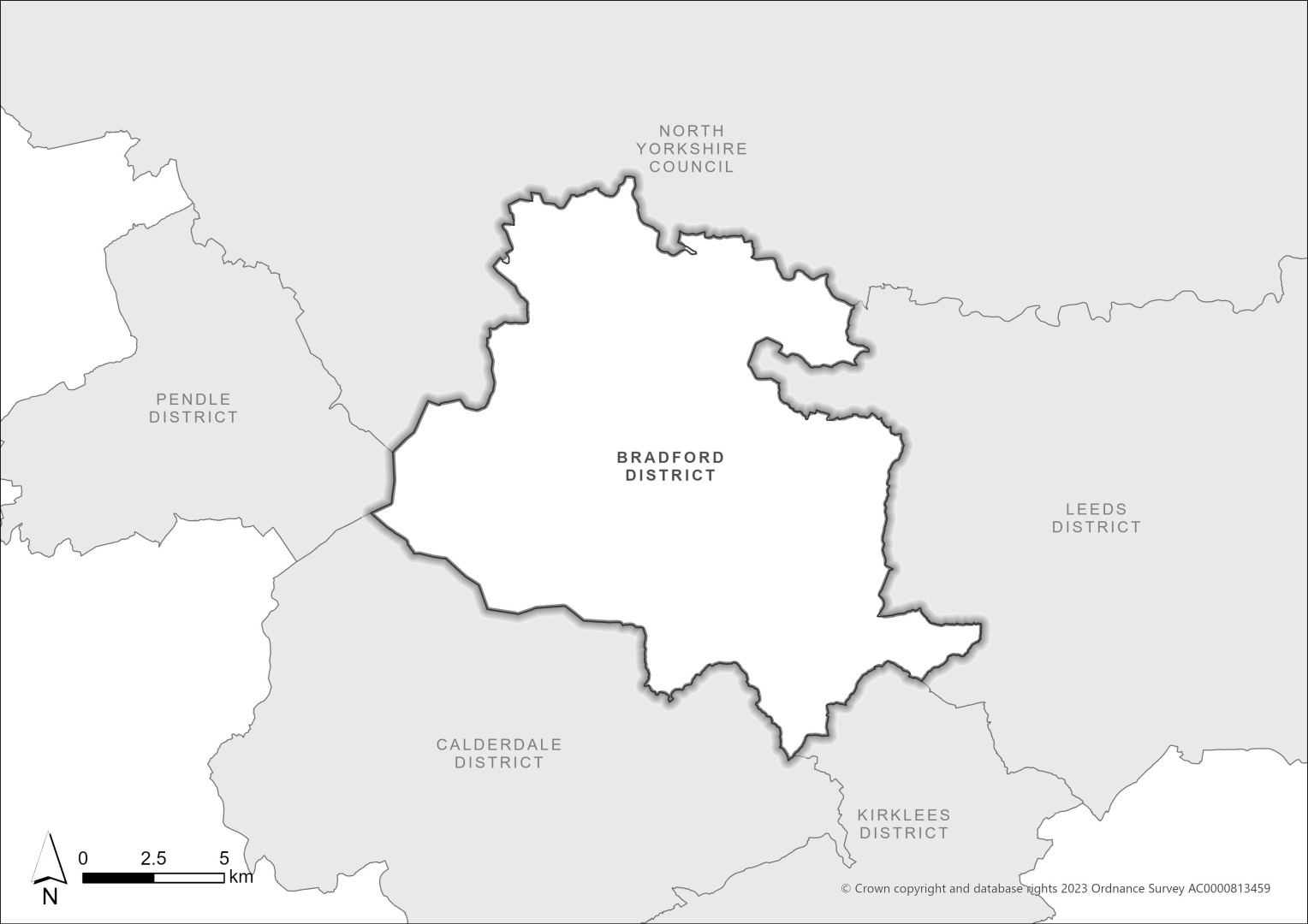
2.2.1Bradford is a large metropolitan District covering approximately 370km2 (143mi2) and forms one of the five Districts within the West Yorkshire conurbation. The District is located within the Leeds City Region. Figure 2.1 below shows the location of the Bradford District in the context of neighbouring authorities.
2.2.2The District is characterised by a mixture of urban and rural areas with distinctive character and attractive landscapes. The topography of Bradford means most of the residential and industrial development is in the south of the District and along the valley bottoms of the Rivers Aire and Wharfe and their tributaries. Much of the population lives in the Regional City and primarily within the towns of Keighley, Ilkley, Bingley, Baildon, Queensbury and Silsden together with the large and medium sized villages of Burley in Wharfedale, Menston, Steeton with Eastburn, Thornton, Cottingley, Haworth (& Cross Roads), Addingham, Cullingworth, Denholme, Oakworth and Wilsden. While the urban areas are quite densely developed, two-thirds of the District is rural with moorland and attractive valleys surrounding the urban areas.
2.2.3One of the most striking features of the District is the quality of its landscape and countryside, particularly the proximity of the main urban areas to areas of high landscape value. The character of the District’s landscape is very varied, ranging from the rugged open moorland of the South Pennine uplands to rolling farmland, and open river valleys to wooded hillsides.
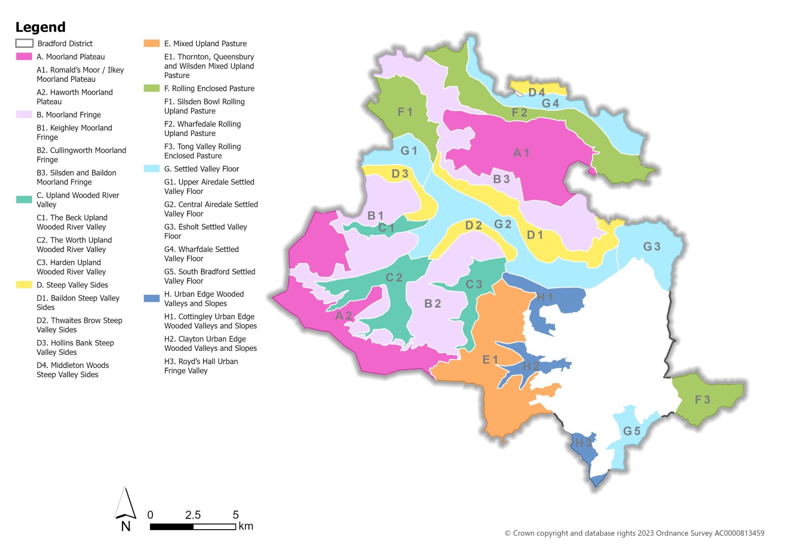
2.2.4Bradford is comprised of eight landscape character types (LCTs): Moorland Plateau, Moorland Fringe, Upland Wooded River Valley, Steep Valley Sides, Mixed Upland Pasture, Rolling Enclosed Pasture, Settled Valley Floor and Urban Edge Wooded Valleys and Slopes. These are detailed below on Figure 2.2.
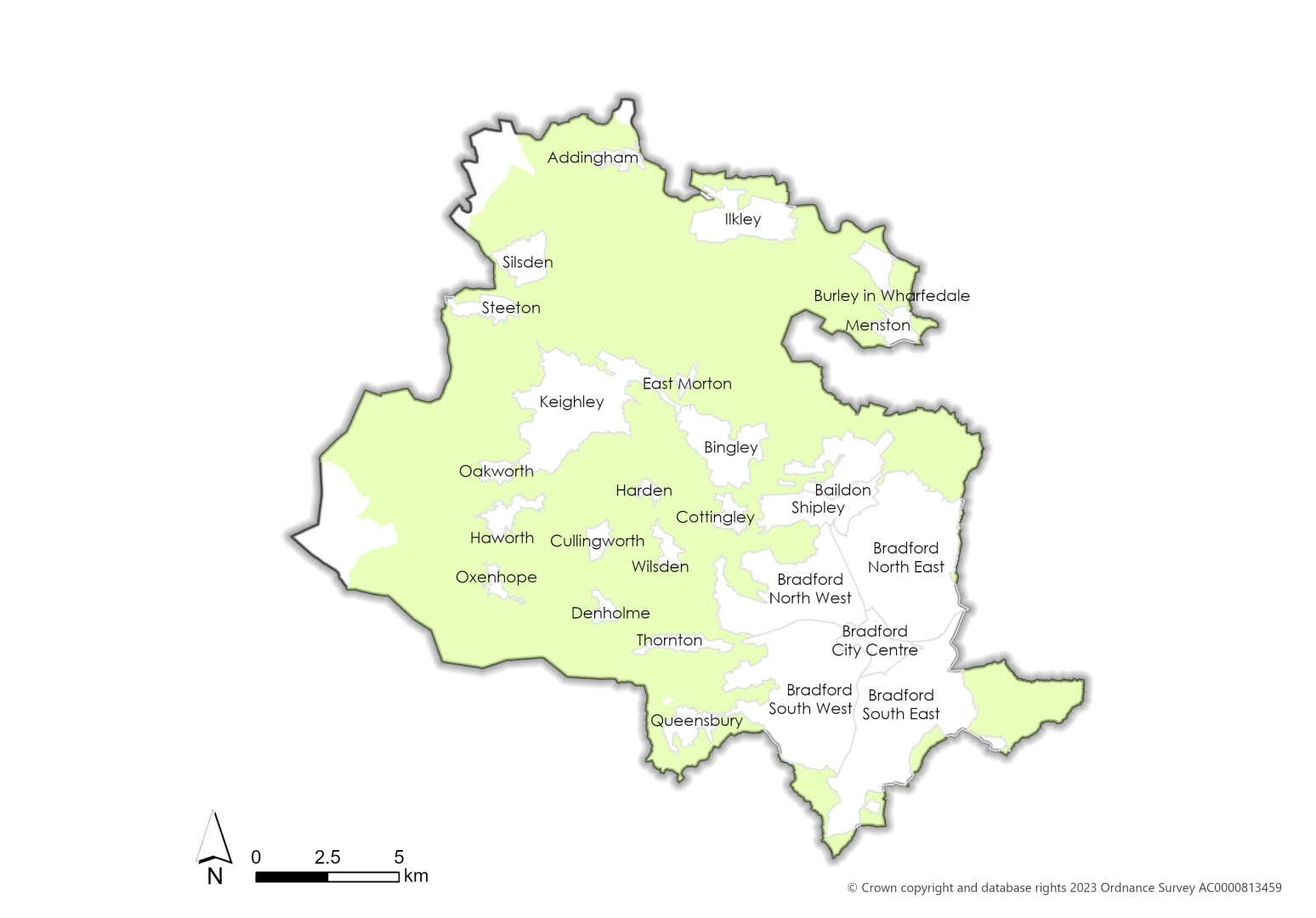
2.2.5The settlements within the District are tightly bound by Green Belt which totals 65% (23,880 hectares) of the Bradford District land mass. This is illustrated in Figure 2.3 below.
2.2.6 With its landscape structure, valleys and river corridors, Bradford District has a history of land and property being flooded through heavy downpours of rain and watercourses overflowing their banks. Potential sources of flooding within the District are main river flooding (i.e. the rivers Aire and Wharfe), localised incidents involving smaller becks and surface water drainage related problems.
Population and Ethnicity
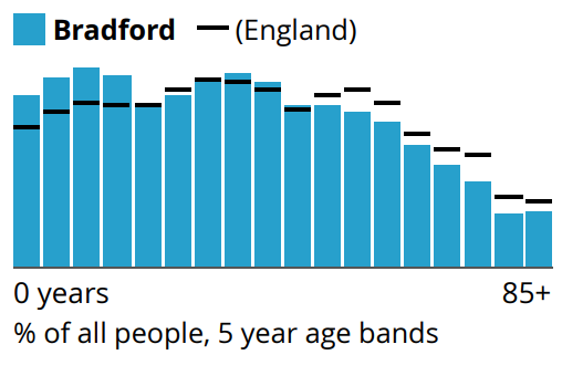
2.2.7Bradford District is the fifth largest local authority area in England in terms of population after Birmingham, Leeds, Sheffield and Manchester. It has a population of 557,758, of which 50.9% are female and 49.1% are male (ONS, 2025).[2] An overview of the age demographics versus the England average, shown in Figure 2.4, highlights that Bradford District has a younger than average population.
2.2.8The under-15 population forms 21.4% of the District’s population, the fourth highest proportion in England. Since the last census in 2011, there has been an increase of nearly two percentage-points in the number of people aged 65 and over and a decrease in the percentage of young and working-age people.
2.2.9The ethnic composition of Bradford District overall is primarily made up of people who identify themselves as white, accounting for 61.1% of the local population. 32.1% of Bradford residents identified their ethnic group within the "Asian, Asian British or Asian Welsh" category. Box 2.2 below indicates how Bradford has changed from the Census in 2011 to 2021 in terms of headline population changes from a selected range of data.
Box 2.2: Bradford Population Changes – Selected Data
- Between the last two censuses (held in 2011 and 2021), the population of Bradford increased by 4.6%, from around 522,500 in 2011 to around 546,400 in 2021.
- Between the last two censuses, the average (median) age of Bradford increased by two years, from 34 to 36 years of age.
- Bradford saw England's joint third-largest percentage-point rise in the proportion of lone-parent households (from 11.1% in 2011 to 13.1% in 2021).
- In 2021, 32.1% of Bradford residents identified their ethnic group within the "Asian, Asian British or Asian Welsh" category, up from 26.8% in 2011. The 5.3 percentage-point change was the largest increase among high-level ethnic groups in this area.
Index of Multiple Deprivation (IMD25)
2.2.10The IMD25 is an overall collated suite of deprivation information and uses 55 separate indicators organised across seven distinct indexes of deprivation (income, employment, education skills and training, health deprivation and disability, crime, barriers to housing and services and living environment) which are combined and weighted to produce the overall index.
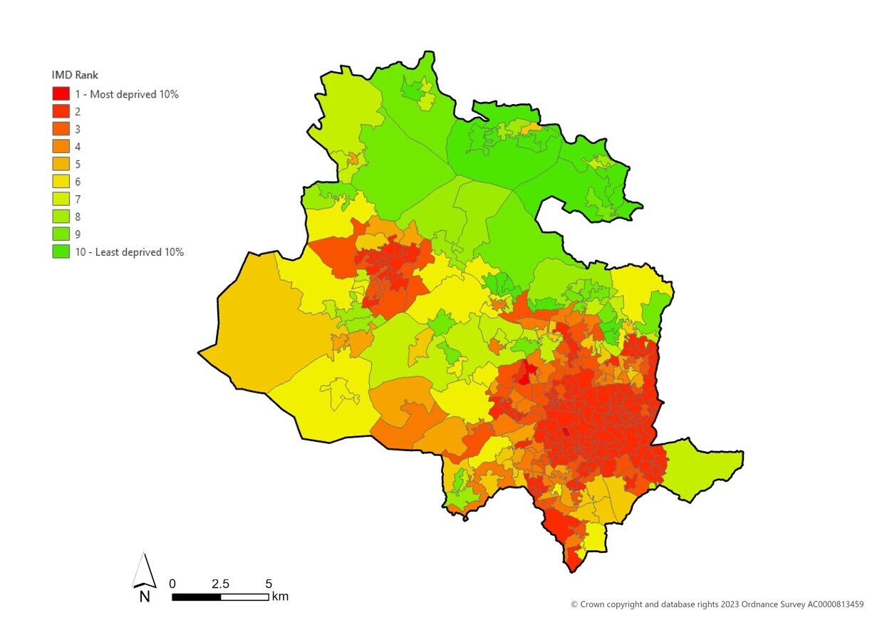
2.2.11Bradford District is ranked as the 12th most deprived out of 296 local authorities in England, its ranking worsening from 19th overall in 2015 and 13th in 2019. Using the Core20PLUS5 framework, which supports tacking health inequality and focuses upon the most deprived 20% of the national population by IMD25, this represents a disproportionately large share of the residents in Bradford with 46.9% of the population living in Core 20 postcodes.[3] Male and Female healthy life expectancy is marginally lower than figures for Yorkshire and the Humber.
2.2.12The most deprived areas in the District are connected to the Regional City with a particular focus within inner-city areas and Keighley. In contrast, areas to the north of the District through Wharfedale and parts of Airedale rank among the least deprived areas in the country. Deprivation has been shown to have impacts that go beyond economic wellbeing, including negative impacts on health and demonstrate the challenges faced by the District which need to be taken into consideration as part of the Local Plan. Figure 2.5 below illustrates IMD geography for Bradford showing rankings across the District.
Economy and Employment
2.2.13Bradford District has the eighth largest economy in England, valued at more than £8.7 billion. It also features one of the UK's youngest cities, with nearly one-third of its population under 25, it offers business access to a growing, diverse, and dynamic workforce. It is also home to over 18,500 active businesses, with sectoral strengths in Bradford is a hub for key sectors including manufacturing, digital technology, financial services, and health innovation.
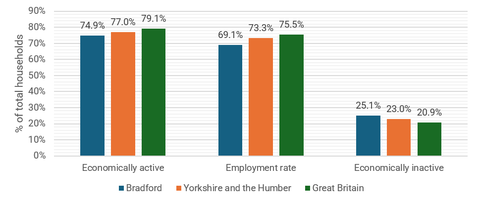
2.2.14In terms of economic activity, 74.9% of the Bradford population (aged 16-64) are economically active, of which 69.1% are in employment and 25.1% are economically inactive. In Great Britain the economically inactive rate sits at 20.9%, meaning Bradford is less economically active than the national average[4]. Figure 2.6 below illustrates Bradford’s economic activity status compared to regional and national averages.
2.2.15According to ONS BRES data[5], the top five highest levels of employee jobs by industry are concentrated in:
- Human health and social work activities (36,000),
- Wholesale and retail trade / repair of motor vehicles and motorcycles (33,000)
- Manufacturing (23,000)
- Education (21,000)
- Jointly – accommodation and food services / admin and support services (13,000 each)
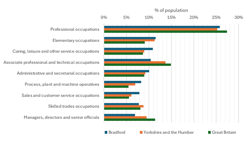
2.2.16ONS Annual Population Survey data on Employment by Occupation indicates that Professional Occupations (25.8%), Elementary Occupations (11.5%) and Caring, Leisure and Other services (10.9%) are the top three occupation classifications within Bradford District. The proportion of people in employment within Professional Occupations is on par with regional percentages but below that of Great Britain (27.4%). Elementary Occupations is again on par with regional figures but higher than the Great Britain figure (9.1%). The figures for Caring, Leisure and Other services is higher than regional and national figures at 9.0% and 8.7% respectively. Data on Employment by Occupation is detailed below in Figure 2.7.
2.2.17ONS reporting on Census 2021 outputs also indicates that Bradford saw Yorkshire and the Humber's largest percentage-point rise in the proportion of people who were economically inactive because they were looking after their family or home (from 6.1% in 2011 to 8.1% in 2021). Job density (in 2024) was recorded at 0.66 – significantly below regional (0.80) and Great Britain (0.85) figures. Job density represents the ratio of total jobs to population aged 16-64. The percentage of the population as a whole with RQF4 and above is lower than regional and national rates and the percentage of population with no qualifications is higher than regional and national comparators. Reflective of wider economic issues, resident wages are often lower than regional and national levels.
2.2.18A series of major companies have their headquarters in the District, including Morrisons, Yorkshire Building Society, Vanquis Banking Group, Hallmark Cards, Freeman Grattan Holdings and Seabrook Potato Crisps. The city centre is a key driver, accounting for 17% of all employment. Canal Road, Leeds Road and the M606 corridors are other major employment locations within the City of Bradford. Airedale provides another key location for employment and is a well-served transport corridor connecting the settlements of Keighley, Bingley and Shipley.
2.2.19Population indicators from ONS however show that that community access to supermarkets (1.9), sports facilities (13.3) and museums (2.8) per 10,000 population is significantly below Yorkshire and the Humber figures of 2.6, 17.7 and 4.2 respectively.
Transport and Movement
2.2.20Bradford District is strategically well located by road and rail, with direct rail links to Leeds, London and Manchester. However, it’s overall transport connectivity as a city is hampered by longer than expected rail journey times within the Leeds City Region and to Manchester, and a low-quality rail interchange terminus station in the city centre and connecting bus station.
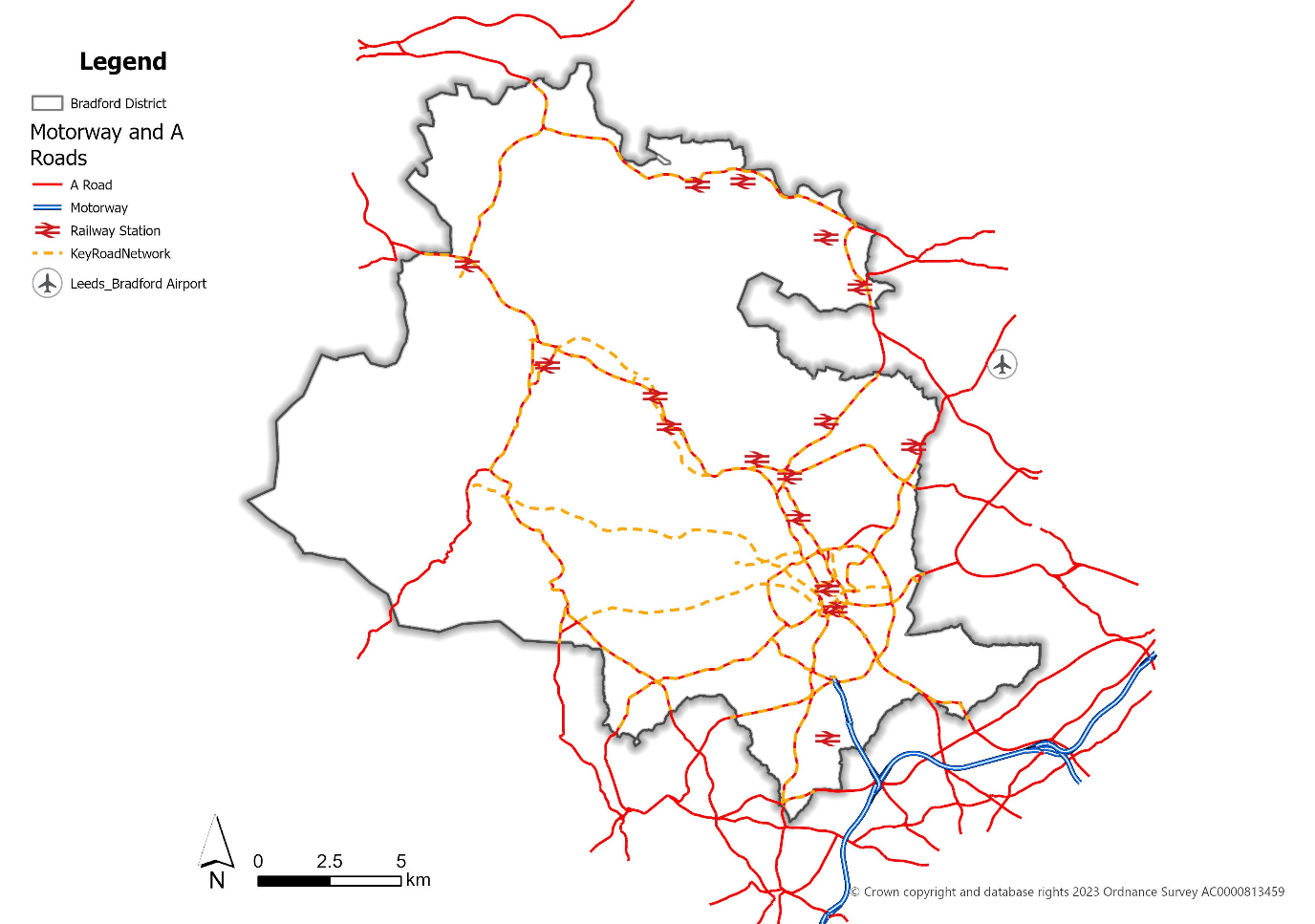
2.2.21There are 16 railway stations within the District, and two railway lines which provide services to Leeds, Halifax and Manchester from Bradford Interchange and to Leeds, Ilkley and Skipton from Bradford Forster Square. There are also several direct services to and from London at both stations. Leeds Bradford Airport is located approximately 6 miles Northeast of the City Centre, just outside the District.
2.2.22The District is connected to the south via the M606 to the M62 and wider Strategic Road Network (SRN).
2.2.23Bradford District has a comprehensive network of rights of way, cycle lanes and paths and less formal routes for non-motorised travel. This includes routes used for everyday access to and from homes, schools and services. It also includes important recreational routes, which are a key amenity for leisure, and a draw for tourism.
2.2.24Bus stations are located at Bradford Interchange, Keighley and Ilkley. In addition to bus stations and stops, there are numerous bus lanes, bus gates and bus-only streets across the District. These are aimed at ensuring the efficient operation of the area’s bus network as part of wider circulation plans.
2.2.25Figure 2.8 below provides a strategic overview of the Bradford District Transport Network Map.
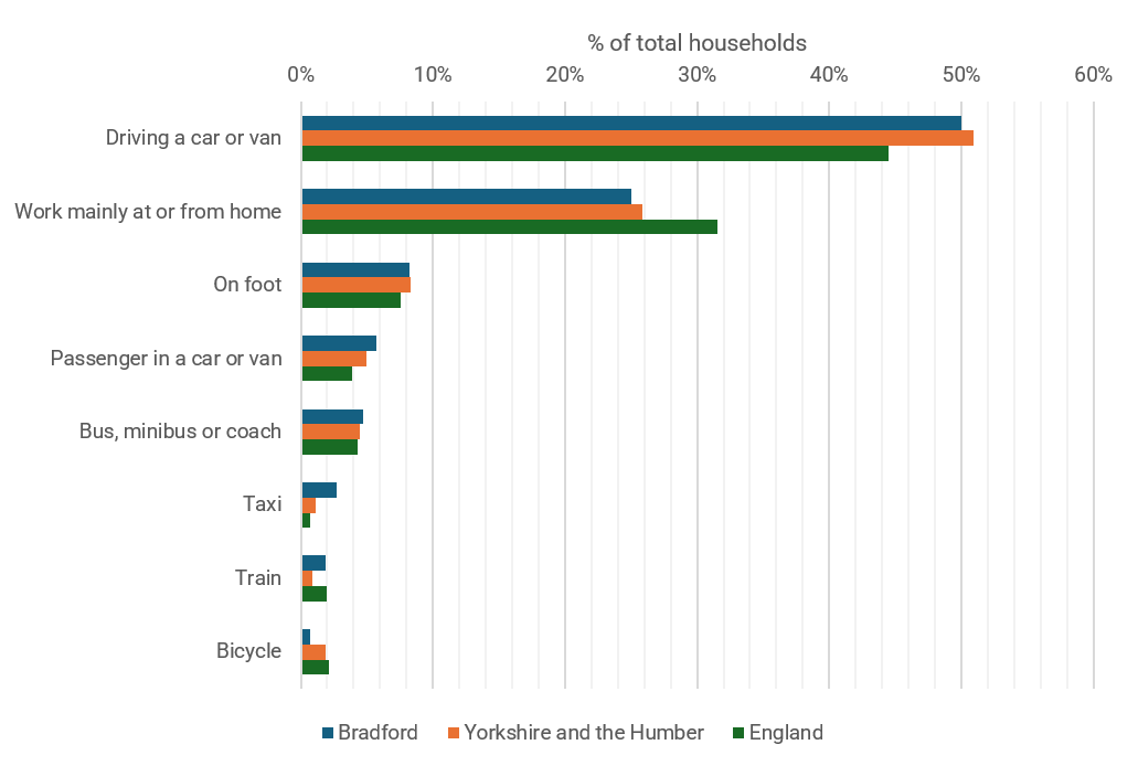
2.2.26Bradford has a lower level of households (7.1%) with two and three cars or vans than the England average (23%). It consequently has a slightly higher level of households with one car or van at 42.4% compared to an England average of 41.3% and higher level of households with no car or van at 27.6% compared to an England average of 23.5%.
2.2.27The most popular method used to travel to work in Bradford is driving a car or van, at 49.6%, (slightly below regional figures) followed by work mainly at or from home at 25.1%, and on foot at 8.2%. The Census 2021 indicated that only 1.9% of Bradford residents travel work by train, but this is likely to be impacted by the survey period. Figure 2.9 below shows in detail the methods used to travel to work in Bradford District compared to regional and national statistics.
Dwellings and Households
2.2.28In 2025 Bradford had 219,093 households on the basis of the ONS (2022 projection – for 2025) which is made up of 31.2% single person households, 33.9% of households with 1 or more dependent children and 35% of households with two or more adults. Household composition forecasts for the year 2043 are indicating an increase in one person households to 38.9%, a significant reduction in households with children to 19.4% and increase in households with two or more adults to 41.8%. The District has a population density of 1,491 people per km2 – this is an increase of 63 people per km2 since the 2011 Census and the highest rate in West Yorkshire.
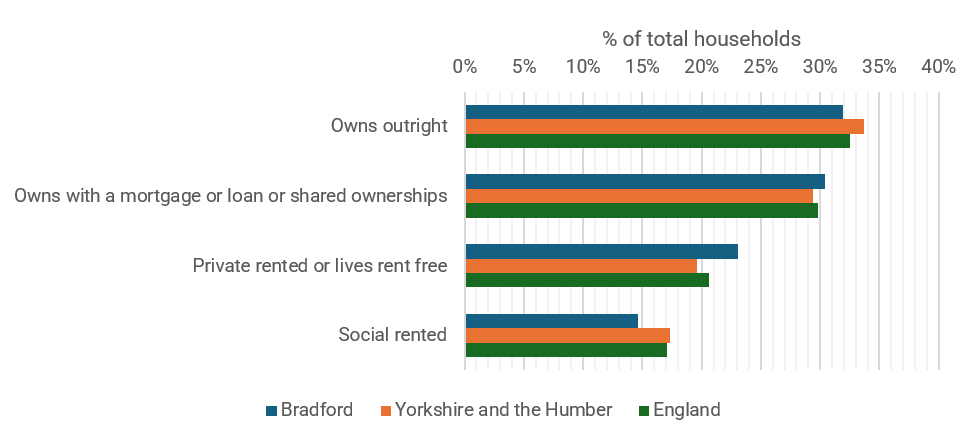
2.2.29Census 2021 data indicates lower levels of outright home ownership at 31.9%, compared to an England average of 32.5% and a Yorkshire and the Humber average of 33.7%. Notably, Bradford has a lower proportion of households that are in social rented accommodation at 14.6% of all households versus the England average of 17.1%. Between 2011 and 2021, Bradford saw Yorkshire and the Humber's largest percentage-point rise in the proportion of privately rented homes (from 18.1% in 2011 to 23.0% in 2021). A more detailed look at tenure of households in Bradford is set out below in Figure 2.10.
2.2.30Bradford has a mix of accommodation types, with a composition of 84.3% whole house or bungalow, 15.4% flat, maisonette or apartment, and 0.3% caravan or other mobile or temporary structure. Compared to the England rates, Bradford has a larger proportion of whole houses and bungalows and a smaller proportion of flats, maisonettes, or apartments.
2.2.31According to the HM Land Registry, the average house price in Bradford District was £182,766 in July 2026. Average house prices have risen by £89,638 from January 2005 to July 2026. The ONS housing affordability ratio (residence-based) was 5.4 at April 2025, similar to Yorkshire and the Humber.
2.2.32Average private rents have risen in Bradford. The average monthly private rent in Bradford was £750 in June 2026, a 4.4% rise from £718 in June 2025. Across Yorkshire and the Humber, the average monthly rent in 2026 was £862, up from £822 a year earlier. Across the UK, the average rent price in June 2026 was £1,388, which was marginally up from £1,344 in June 2025.
2.2.33The shortage of affordable housing is a major issue for both urban and rural areas. Affordability issues in Wharfedale, Airedale, the Worth Valley and some outlying suburbs of Bradford where house prices are high. Affordability is also a critical issue in the inner city are where income levels are particularly low.
Historic Character
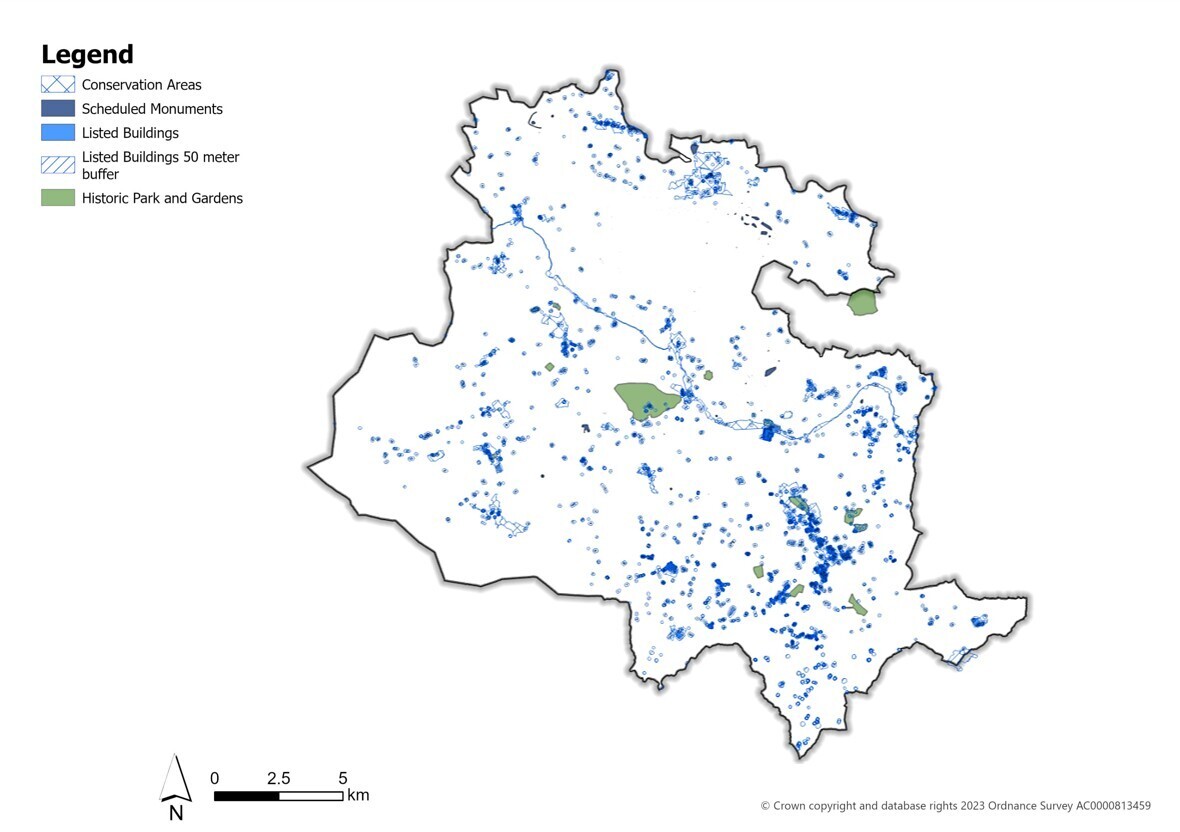
2.2.34Bradford District contains a rich and diverse built heritage. It has the third highest number of designated assets in the region and one of only two World Heritage Sites in Yorkshire at Saltaire. There are over 2500 entries on the National Heritage List for Bradford District’s ranging from 16th century farmsteads and parish churches to the terraces, houses and civic grandeur of Victorian expansion. The architectural and historic wealth of protected buildings and 60 designated Conservation Areas are highly valued for the essential contribution they make to local distinctiveness and environmental identity. The benefits of the built heritage to the economy and tourism have been demonstrated by successful regeneration projects.
2.2.35Bradford also has a distinctive legacy of historic mill buildings and industrial architecture. However, a relatively large number of these buildings are either empty or underused. There are three Grade II* Mills on the Heritage at Risk register and these and other protected heritage assets present regeneration challenges which will require proactive and inventive solutions to ensure their assured future. Figure 2.11 provides a high-level overview of the location of the District’s many heritage assets.
Natural and Environmental Assets
2.2.36There are over 1,600 designated open space sites totalling almost 2,800ha of land (covering approximately 7.5% of the District) plus protection for 108 local wildlife sites, 16 local geological sites, 13 Local Nature Reserves (LNR), 4 SSSIs, 1 SPA/SAC and a new National Nature Reserve which spans 1,272ha across eight sites. There are significant areas of the Bradford District which provide a valuable recreational resource as well as having landscape and biodiversity benefits.
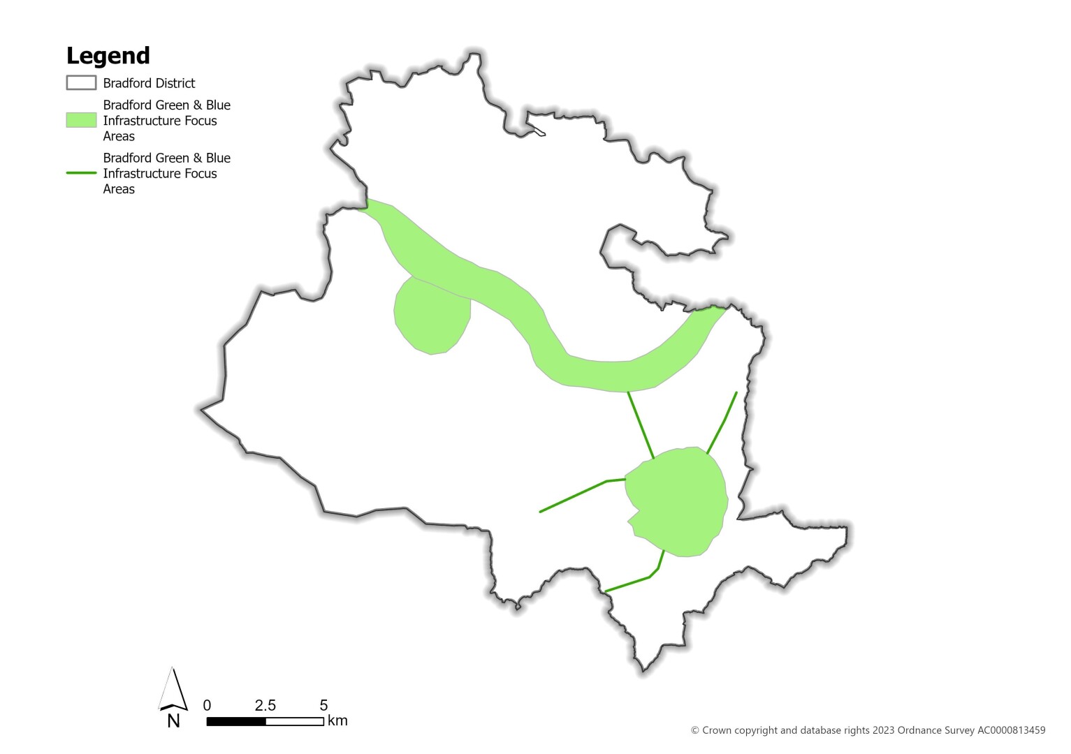
2.2.37Bradford has a range of important corridors and spaces that contribute towards its Green and Blue Infrastructure (GBI) network throughout the District but also deficits in provision and priority locations for enhancement and further development. Key GBI improvement and focus areas and corridors include Bradford City Centre, Keighley, and Keighley-Bingley-Shipley Corridor, as detailed below on Figure 2.12.
2.2.38 The spatial portrait has outlined some of the District’s unique characteristics and contributes towards informing the Local Plan’s Vision and Strategic Objectives, which set the strategic direction for the District’s growth and development over the plan period.
2.3 Plan Strategy
Spatial Vision
2.3.1The Local Plan sets out a positive vision for the future of the Bradford District which provides a framework for sites and policies within the plan period but also underpins the longer-range direction of transformation and growth across our neighbourhoods and communities.
Box 2.3 – Spatial Vision
By 2043 the Bradford District will be a much sought after and desirable location where people want to live and visit, do business, shop and spend their leisure and recreation time. It will be greener, lower carbon, better connected and with diverse safe neighbourhoods and inclusive communities contributing to the economic and cultural vibrancy of the district.
The Regional City of Bradford will be a central focus of regeneration, physical transformation, homes and jobs capitalising on new transport infrastructure to revitalise the reshaped and expanded City Centre and continue to attract new economic, educational and cultural investment. The large and medium towns of Keighley, Bingley, Baildon and Ilkley will be key areas of services and facilities outside of the City, with levels of housing delivery aimed at promoting sustainable growth whilst developing and retaining the individual character and environmental quality together with heritage assets of these distinctive towns.
Bradford’s smaller towns and villages will continue to play a vital role as locations for local services and facilities, while contributing to appropriate levels of housing to meet needs.
Growth will be people-focused, ensuring a diverse range of housing and employment, opportunities for increased active travel and access to quality green spaces to support healthy communities. New development will be delivered in a way that mitigates against and adapts to the causes and impacts of climate change. It will have taken account of flood risk, be energy efficient and feature high-quality design with a focus upon place-making. Physical and social infrastructure will be delivered of the right scale and at the right time to support the effective integration of new development and communities.
The District’s unique and distinctive landscapes, heritage, and biodiversity assets continue to play a vital role in making great places that encapsulates what makes Bradford District so special.
Strategic Objectives
2.3.2The following 20 key strategic objectives articulate high level measurable goals which indicate how the vision for the Local Plan will be delivered. The objectives are specific, achievable, attainable and realistic in what they seek to achieve to fulfil the vision over the plan period. The Local Plan monitoring framework will measure whether the strategic objectives are being achieved.
Box 2.4 – The Spatial Vision for Bradford District will be achieved through the following strategic objectives:
Strategic Objective 1: Supporting Transformation and Regeneration in Bradford District through new homes
Housing delivery will be targeted in key areas of growth and regeneration, including the Regional City of Bradford and town of Keighley with housing growth also planned for the district’s sustainable settlements, to ensure the benefits of sustainable growth are widespread.
Strategic Objective 2: Delivering the District’s Development Needs
To ensure that the development requirements for the district including for housing and employment growth are met in full in sustainable locations that reduce the need to travel and are well served by active travel options and public transport and services.
Strategic Objective 3: Efficient use of land
The use of deliverable and developable previously developed land will be prioritised, together with ensuring that the most efficient use of land is made by achieving minimum housing density standards and maximising density levels within well-connected accessible locations.
Strategic Objective 4: Delivering Infrastructure for Growth
To support investment in and enhancement of essential physical, community, digital and green infrastructure in a timely and co-ordinated manner through appropriate funding and planning contributions to ensure that existing and future residents and visitors have access to high-quality facilities and services that meet their needs and support future growth and development.
Strategic Objective 5: Quality Design and Placemaking
To significantly improve the quality of development through good design which puts place first and is built through a collaborative process in understanding sustainability, site constraints and opportunities, context and local character, design quality, and appropriate application of design tools to positively transform places, support regeneration and deliver new development which are well-connected attractive, safe and distinctive.
Strategic Objective 6: Access to Secure and Affordable Housing
Everyone in the district has access to decent, safe, secure housing, by supporting affordable housing that has a range and choice of high-quality, well-designed homes of all types and tenures, that also meets the diverse needs of all parts of the community including those with specialist requirements.
Strategic Objective 7: Supporting a Growing Economy
To continue to promote and support the conditions for a successful growing economy and unlock economic opportunities through a range of business locations, land and premises to facilitate employment and skills development, by fostering indigenous firms and attracting inward investment including within current and emerging priority knowledge based economic sectors in the district.
Strategic Objective 8: Vibrant City, Town and District Centres
To continue to support Bradford City Centre and the varied town, district and local centres across the district as vibrant, diverse and economically resilient places that are a key focus for a mix of commercial, retail, leisure, community, cultural and residential uses which are able to respond flexibly to investment and regeneration opportunities to promote long term vitality and viability.
Strategic Objective 9: Increasing Skill Levels
To continue to support the development of the skills, training and education base in the district to build capacity through the University of Bradford, the District’s Further Education Colleges and schools to grow and develop by investing in their buildings and estates and also the creation of new opportunities for apprenticeships and business collaborations to ensure that residents and the local workforce can thrive in the future economy.
Strategic Objective 10: Delivering Improved Transport Connectivity and Sustainable Transport Networks
To deliver improved transport connectivity across the district including progressing a new through centre rail station in Bradford; West Yorkshire Mass Transit with reliable, high-capacity and high frequency services alongside a safe, efficient and sustainable existing sustainable transport network that prioritises public transport and increased opportunities for active travel including walking and cycling, plus uptake of low emission vehicles supporting air quality improvements, a reduction in congestion and low carbon growth.
Strategic Objective 11: Conserving and Enhancing the Historic Environment
To conserve and enhance the significance of the district’s diverse historic and built heritage including nationally and internationally designated and non-designated heritage assets and their settings including the Outstanding Universal Value of the Saltaire World Heritage Site, as well as our wide range of Conservation Areas, Listed Buildings, archaeological sites and historic parks and gardens while reinforcing and sustaining its local distinctiveness, culture and character.
Strategic Objective 12: Tackling the Impacts of Climate Change
To move to a net-zero district and tackle the impacts of climate change through mitigation and adaptation, in particular by reducing emissions, energy consumption, and flood risk, increasing energy efficiency, the use of renewable and low carbon energy, and securing gains for biodiversity while maximising co-benefits including social mobility, investment and job creation, skills development, household cost reductions, better health and more equitable and inclusive communities.
Strategic Objective 13: Enhancing the Green and Blue Infrastructure Network
To protect, enhance and increase the provision of green and blue infrastructure across the district through multi-functional, interconnected, attractive and accessible recreational networks, supporting opportunities for physical activity and social interaction through the provision of new or enhanced high-quality open spaces, green and blue infrastructure networks, sporting and recreation facilities and countryside access.
Strategic Objective 14: Protecting and Enhancing the Natural Environment
To protect and enhance the district’s range of biodiversity and geodiversity assets from the internationally and nationally designated sites of the South Pennine Moors (and its upland fringe) to locally significant natural assets, together with the delivery of the Local Nature Recovery Strategy (LNRS) and biodiversity net-gain as well as through careful management of the area’s landscapes, grasslands and heathlands, woodlands and water environments.
Strategic Objective 15: Safeguarding Our Natural Resources
To ensure the prudent and efficient use of the district’s natural resources including its agricultural land, soils, minerals, woodland, water, whilst protecting and enhancing air, water and soil quality and minimising adverse impacts on communities and the environment.
Strategic Objective 16: Delivering Healthy Places and Communities
To promote health and wellbeing and reduce health inequalities by creating and delivering healthy places and communities across the district that increased access to nature and green spaces, sport and recreation facilities, heritage and cultural facilities, healthcare provision and enable access to healthy food choices and high-quality homes and jobs while also creating places that are safe, accessible and distinctive alongside encouraging and enabling local people to live healthy and active lifestyles.
Strategic Objective 17: Enhancing Environmental Quality
To enhance the District’s environmental quality and safeguarding the health and wellbeing of its communities from hazardous sites and installations and by improving its air, water and soil quality, minimising and preventing pollution, reducing emissions levels and tackling the area’s legacy of contaminated land through its remediation, re-use and redevelopment to create opportunities and locations for sustainable growth.
Strategic Objective 18: Supporting Tourism and the Visitor Economy
To support the sustainable growth of Bradford District as a diverse tourism and visitor destination contributing to the local economy with its natural beauty, vibrant communities, varied built and cultural heritage, including historic settlements and two UNESCO designations – Bradford City of Film and World Heritage Site at Saltaire, alongside the legacy of numerous literary and artistic greats
Strategic Objective 19: Ensuring Minerals Supply
Ensure that the District, working with its neighbouring authorities, maintains a steady and adequate supply of mineral resources to meet development needs in line with the principles of sustainable development, whilst protecting the environment and communities and also safeguarding economically important mineral resources, minerals sites and minerals-related infrastructure from incompatible development.
Strategic Objective 20: Sustainable Waste Management
Manage the District’s waste in a sustainable way by reducing the level of waste produced and supporting increased re-use and recycling with disposal as a last resort, in line with the Waste Hierarchy through an appropriate network of facilities, whilst protecting the environment, amenity and health of communities.
[1] Design Code Pathfinder
[2] Unless otherwise stated, the statistics presented are deprived from ONS 2021 Census data.
[5] Bradford NOMIS profile – accessed 23/09/26
