Skip to main content
Login
|
Register
Bradford Council
Consultations
Bradford District Local Plan - Publication Draft (Regulation 19) (October 2026)
Appendices
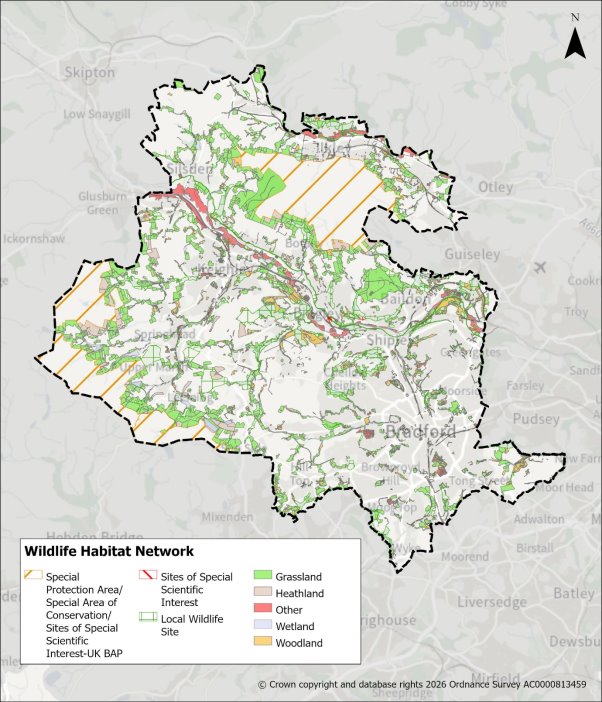
Appendix 16 Wildlife Habitat Network Map
Bradford District Local Plan - Publication Draft (Regulation 19) (October 2026)
Ends on 30th November 2026
(41 days remaining)
Section 1: Consultation Introduction
1.1 Overview
Local Plan Progress
Consultation and Representations
Post Consultation and Timetable
Section 2: Plan Introduction
2.1 Plan Directions
Delivering Sustainable Development
Unlocking Urban Growth and Regeneration
A Balanced Approach to Growth
Quality of Place and Good Design
Plan in Numbers
Preparation of the Plan
National Planning Policy Framework
Development of Plan Evidence
Impact Assessments
Local Strategies and Plans
Effective Co-operation
2.2 District Portrait
Location and Character
Population and Ethnicity
Index of Multiple Deprivation (IMD25)
Economy and Employment
Transport and Movement
Dwellings and Households
Historic Character
Natural and Environmental Assets
2.3 Plan Strategy
Spatial Vision
Strategic Objectives
Section 3: Spatial Strategy and Strategic Policies
3.1 Introduction
Spatial Strategy
POLICY SS1: Spatial Strategy
POLICY SS2: Growth Requirements
POLICY ST1: DELIVERING SUSTAINABLE DEVELOPMENT
Policy ST2: Sustainable Movement and Connectivity
POLICY ST3: Climate Change, Sustainability and Resource Use
POLICY ST4 – CREATING WELL DESIGNED AND HEALTHY PLACES
POLICY ST5: GREEN BELT
Policy ST6: Strategic Green and Blue Infrastructure Network
Key Diagram
Section 4: Thematic Policies
4.1 Introduction
Planning for Homes
POLICY HO1: HOUSING DELIVERY
POLICY HO2: HOUSING DENSITY
POLICY HO3: HOUSING MIX
POLICY HO4 – AFFORDABLE HOUSING
POLICY HO5: SELF-BUILD & CUSTOM-BUILD HOUSING
POLICY HO6: SUPPORTED AND SPECIALIST ACCOMODATION
POLICY HO7 – GYPSY AND TRAVELLER AND TRAVELLING SHOWPERSONS ACCOMMODATION
POLICY HO8 – HOUSING DESIGN STANDARDS
POLICY HO9: EMPTY HOMES AND OVERCROWDING
POLICY HO10: HOUSES IN MULTIPLE OCCUPATION
Planning for Prosperity
Economy
POLICY EC1: EMPLOYMENT SITES
POLICY EC2: EMPLOYMENT ZONES
POLICY EC3: EMPLOYMENT SKILLS AND DELIVERY
POLICY EC4: SUSTAINABLE TOURISM AND THE VISITOR ECONOMY
Retail & Town Centre
POLICY TC1: Hierarchy of Centres AND GROWTH NEEDS
POLICY TC2: DEVELOPMENT WITHIN DESIGNATED CENTRES
POLICY TC3: OUT OF CENTRE DEVELOPMENT
POLICY TC4: HOT FOOD TAKEAWAYS AND FAST FOOD OUTLETS
Transport & Connectivity
POLICY TR1: SAFEGUARDING LAND FOR TRANSPORT INFRASTRUCTURE
POLICY TR2: INTEGRATING SUSTAINABLE TRANSPORT & DEVELOPMENT
POLICY TR3: PARKING
POLICY TR4: WALKING AND CYCLING
POLICY TR5: FREIGHT & LOGISTICS
POLICY TR6: AIRCRAFT SAFETY
Planning for Places & Communities
Design and Place-making
POLICY DS1: DESIGN PROCESS
POLICY DS2: LANDSCAPE DESIGN
POLICY DS3: URBAN CHARACTER AND FORM
CHARACTER ASSESSMENT CHECKLIST
POLICY DS4: STREET DESIGN
Supporting Sustainable Communities
POLICY SC1: COMMUNITY FACILITIES AND INFRASTRUCTURE
POLICY SC2: CEMETERY AND BURIAL PROVISION
POLICY SC3: EDUCATION INFRASTRUCTURE
POLICY SC4: PROVISION OF HEALTH INFRASTRUCTURE
POLICY SC5: SPORTS AND RECREATION PROVISION
POLICY SC6: DIGITAL AND TELECOMMUNICATIONS CONNECTIVITY
Climate & Resources
POLICY CR1: AIR QUALITY
POLICY CR2: ENVIRONMENTAL PROTECTION
POLICY CR3: RENEWABLE AND LOW CARBON ENERGY
POLICY CR4: FLOOD RISK AND WATER MANAGEMENT
Natural Environment
POLICY NE1: GREEN AND BLUE INFRASTRUCTURE STANDARDS
POLICY NE2: OPEN SPACE, PLAY, SPORT AND RECREATION
POLICY NE3: PROTECTING THE SOUTH PENNINE MOORS SPA/SAC
POLICY NE4: BIODIVERSITY AND GEODIVERSITY
POLICY NE5: BIODIVERSITY AND DEVELOPMENT (INC. NET GAIN)
POLICY NE6: TREES, WOODLANDS AND HEDGEROWS
POLICY NE7: LANDSCAPE CHARACTER AND SENSITIVITY
POLICY NE8: DEVELOPMENT IN THE COUNTRYSIDE
POLICY NE9: DEVELOPMENT IN THE GREEN BELT
Historic Environment
POLICY HE1: HISTORIC ENVIRONMENT
Minerals
POLICY MIN1: PLANNING FOR MINERALS
POLICY MIN2: MINERALS SUPPLY AND LANDBANKS
POLICY MIN3: MINERAL SAFEGUARDING
POLICY MIN4: MINERAL INFRASTRUCTURE SAFEGUARDING
POLICY MIN5: MINERAL ALLOCATIONS
POLICY MIN6: MINERALS AREA OF SEARCH
POLICY MIN7: PROPOSALS FOR NEW OR EXTENDED MINERAL SITES
POLICY MIN8: MINERAL SITE RESTORATION, AFTERCARE AND AFTERUSE
POLICY MIN9: OIL & GAS (HYDROCARBON) EXPLORATION AND PRODUCTION
POLICY MIN10: COAL EXTRACTION
Waste
POLICY WAS1: PLANNING FOR SUSTAINABLE WASTE MANAGEMENT
POLICY WAS2: WASTE MANAGEMENT ALLOCATIONS
POLICY WAS3: SAFEGUARDING WASTE MANAGEMENT FACILITIES AND INFRASTRUCTURE
POLICY WAS4: PROPOSALS FOR WASTE MANAGEMENT DEVELOPMENT
POLICY WAS5: WASTE MANAGEMENT WITHIN DEVELOPMENT
Section 5: Settlement Policies & Site Allocations
5.1 Introduction
Section 5: Settlement Policies & Site Allocations for Regional City
Policy BCC1: Bradford City Centre
POLICY BCC1 BRADFORD CITY CENTRE
Bradford City Centre: Site Allocations
H127: Ham Strasse, City Centre
H151: Sunwin House, Godwin Street, City Centre
H171: Buildings at Bradford College, Great Horton Road, City Centre
H217: Tetley Street/Sunbridge Road, City Centre
H218: Land and buildings south of Sunbridge Road, City Centre
H219: Wigan Street/Chain Street, City Village, City Centre
H220: Top of Town, City Village, City Centre
H223: North Brook Street/Valley Road, City Centre
H225: Beehive Mills, Smith Street
H229: Land west of Wharf Street, City Centre
H230: Cathedral Quarter Phase 1
H231: Land and buildings east of Grattan Road, City Centre
H232: Listerhills Road
H233: Captain Street/Bolton Road, City Centre
H234: Sun Street, City Centre
H235: Midland Mills, Valley Road, City Centre
H238: Tetley Street/Fulton Street, City Centre
H599: Barkerend Mill, Barkerend Road, Barkerend
H1163: Between Clayton Lane and Lister Arms
H1164: Park Road, Little Horton
H1349: Kirkgate Centre, Darley Street, City Centre
H1553: West of Manchester Road, Little Horton
H1559: Burnett Street/Barkerend Road, City Centre
Policy BNE1: Bradford North East
Vision
POLICY BNE1: BRADFORD NORTH EAST
Bradford North East: Site Allocations
H262: Bolton Road, Barkerend
H265: North Bolton Hall Road
H266: Thornhill Avenue
H585: Roundwood Glen, Ravenscliffe
H588: All Alone Road/Lynmoor Court, Idle
H594: Doctor Hill, Idle
H597: Wapping Road, Barkerend
H598: Exmouth Place (2), Barkerend
H636: Land east of Harrogate Road (2), Greengates
H666: Highfield Works, off Highfield Road, Wrose
H670: Lister Lane, Barkerend
H673: Land at Ravenscliffe Community Centre, Ravenscliffe Avenue
H674: East of Harrogate Road (1), Greengates
H675: Rushton Avenue, Thornbury
H680: Rimswell Holt, Ravenscliffe
H681: Eccleshill Football Club, Kingsway, Wrose
H683: Prospect Road, Barkerend
H685: Old Park Road, Thorpe Edge
H1558: Land at Friars Industrial Estate, Idle (1)
MDS1: Esholt Wastewater Treatment Works North
MDS2: Esholt Wastewater Treatment Works South
Policy BNW1: Bradford North West
POLICY BNW1 BRADFORD NORTH WEST
Bradford North West: Site Allocations
H687: Snowden Street
H689: Midland Road
H694: Haworth Road, Sandy Lane
H699: Ivy Lane, Allerton
H704: Whitburn Way, Allerton
H706: East of Allerton Lane
H719: Alton Grove, Frizinghall
H720: Saffron Drive, Allerton
H726: Hill Top Lane, Allerton
H753: Emmfield Drive, Heaton
H760: Land south of Allerton Road
H761: Woodward Court, Kirklees Road, Allerton
H772: Allerton Road, Prune Park Lane, Allerton
H773: North Parade, Allerton
H774: Lynfield Drive, Daisy Hill
H775: Millmoor Close, Daisy Hill
H776: Merrivale Road/Allerton Lane, Allerton
H779: Haworth Road Playing fields (1), Heaton
H780: Bingley Road/Long Lane, Heaton
H781: Site of Drummond Mills, Lumb Lane
H782: Carlisle Road/Toller Lane, Manningham
H783: Whetley Mills
H784: Rayner Mount, Allerton
H787: Patent Street, Manningham
H788: Spring Bank Place, Manningham
H789: Allerton Mills, Allerton
H790: Lister Mill and Surrounds/Velvet Mill, Manningham
H794: Priestman Street, Mannningham
H795: Acacia Drive, Sandy Lane
H796: High Ash Farm, Allerton Road, Allerton
H797: Wilsden Road/West Avenue, Sandy Lane
H1562: Allerton Lane/Chevet Mount, Allerton
Policy BSE1: Bradford South East
POLICY BSE1: BRADFORD SOUTH EAST
Bradford South East: Site Allocations
H879: Spen View Lane/Shetcliffe Lane, Bierley
H883: Kesteven Drive, Holme Wood
H894: Holme Lane/Raikes Lane, Holme Wood
H897: Wilson Road, Wyke
H902: Summer Hall Ing, Delph Hill
H911: Westgate Hill, Holme Wood
H920: Broadstone Way, Holme Wood
H924: Hudson View, Wyke
H931: Flockton Road/Brompton Avenue, East Bowling
H932: Flockton Road, East Bowling
H946: Westgate Terrace, Holme Wood
H956: Land South of Titan District Centre, Wyke
H962: St Lukes Church Dane Hill Drive, Holme Wood
H975: Highbridge Terrace, West Bowling
H976: Land at Muirhead Fold, Holme Wood
H979: Ned Lane, Holme Wood
H983: Kesteven Road/Heysham Drive, Holme Wood
H987: New Lane (2), Laisterdyke
H989: Tennis Avenue, Holme Wood
H990: Grayswood Drive, Holmewood
H991: Mead View, Holme Wood
H992: Somerton Drive, Holme Wood
H993: Kaycell Street, Bierley
H994: Cleckheaton Road, Low Moor
H997: Harper Gate Farm, Tyersal
H1001: Upper Castle Street, West Bowling
H1003: Landscove Avenue, Holme Wood
H1004: Greyswood Drive, Holme Wood
H1005: Stonyhurst Square, Holme Wood
H1554: Tong Academy and Yorkshire Martyrs
H1555: Proctor Street, Holme Wood
H1557: Albert Terrace and Furnace Road, Oakenshaw
H1564: Ned Lane, Holme Wood
E34: Land at M606, Junction 2 to M62 Southbound
E38: Land at Wharfedale Business Centre, Shetcliffe Lane
E55: Land East of Sticker Lane
E57: North of Westgate Hill and West of Tong Lane
E59: Neville Road / Lower Lane
E61: Westgate Hill Street
E151: Former site of Argonaut Works, Laisterdyke
E152: Staithgate Lane
Nufarm South
E157 NUFARM SOUTH STRATEGIC EMPLOYMENT SITE
Policy BSW1: Bradford South West
POLICY BSW1 BRADFORD SOUTH WEST
Bradford South West: Site Allocations
H1144: Highgate Grove, Clayton Heights
H1153: Cannon Mills, Cannon Mill Lane, Great Horton
H1173: Legrams Lane, Lidget Green
H1225: Reevy Road west/The Crescent, Buttershaw
H1227: Former Hare and Hounds pub, Great Horton Road, Horton Bank Top
H1243: Canterbury Youth Centre, Dawnay Road, Little Horton
H1248: Back Fold, Clayton
H1249: Stocks Lane, Old Dolphin, Clayton Heights
H1252: Fenwick Drive, Woodside
H1254: Briggella Mills/Little Horton Lane, Little Horton
H1255: Fall Top Farm, Brook Lane, Clayton
H1257: Quaker Lane, Southfield Lane, Little Horton
H1258: Thornton Road, Leaventhorpe
H1259: East of Baldwin Lane, Clayton
H1260: Northside Road, Lidget Green
H1262: Lingdale Road, Woodside
H1263: Abb Scott Lane, Low Moor
H1265: Abb Scott Lane, Low Moor
H1266: Ferndale, Clayton
H1270: Land off Buckingham Crescent, Clayton
H1273: Highgate Road
H1274: Cousen Road, Little Horton
H1275: Bowman Road, Wibsey
H1276: Brook Lane, Clayton
H1277: Blamires Street, Great Horton
H1281: Theakston Mead/Thirsk Grove, Clayton
H1282: Frensham Drive, Great Horton
H1283: Woodlands Road
H1357: Holts Lane, Clayton
H1548: East of Baldwin Lane (Langberries), Clayton
H1556: Bell House, Southfield Lane, Great Horton
H1575: Former Football Ground, Hollingwood Mount, Great Horton
E75: Former site of Dunoon House, Newall Street
E76: Former Rushworth Works, Beckside Road
E82: Thornton Road / Munby Street
E83: Northside Road
E85: Ingleby Road
Policy SP1: Shipley
POLICY SP1 - SHIPLEY
Shipley: Site Allocations
H1011: Carr Lane, Windhill
H1030: Shipley Hospital, Kirkgate, Shipley
H1037: Old Mill House, Dockfield Road, Shipley
H1044: West Victoria Street, Shipley
H1047: Regent House, Dockfield Road, Shipley
H1052: Land between Leeds Road and Dock Lane, Shipley
H1055: Wrose Brow Road, Windhill
H1056: Browfoot/Wrose Brow Road, Windhill
H1059: Bingley Road, Nab Wood
H1061: Queens Road/Ferncliffe Road, Saltaire
H1563: Wycliffe Road and Thompson Street, Shipley
E159: Crag Road
Section 5: Settlement Policies & Site Allocations for Airedale
POLICY BA1 – BAILDON
Baildon (including Lower Baildon): Site Allocations
H28: South of West Lane, Baildon
H57: Land north of Richard Whiteley Drive, Baildon
H1565: Green Lane/Southdown Road, Baildon
POLICY BI1 – BINGLEY
Bingley: Site Allocations
H77: Laurel Bank, Sheriff Lane, Eldwick
H105: Sty Lane, Bingley
H106: Greenhill Barn, Lady Lane, Bingley
E8: John Escritt Road: Site Boundary
POLICY CO1 – COTTINGLEY
Cottingley: Site Allocations
H249: Marchcote Lane, Cottingley
POLICY EM1 – EAST MORTON: Settlement Plan
East Morton: Site Allocations
H306: High Stead, Street Lane, East Morton
H1110: Morton Lane, East Morton
Policy KY1: Keighley
Vision for Keighley
POLICY KY1 Keighley
Keighley: Site Allocations
H388: Hollins Lane (north), Utley
H393: Shann Lane, Keighley
H420: Bradford Road, Riddlesden
H508: Aire Valley Business Centre, Lawkholme Lane
H522: Land north of Skipton Road, Utley
H528: Marlborough Street, Keighley
H533: Holmewood Residential, Fell Lane, Exley Head, Keighley
H538: Keighley Road, Exley Head, Keighley
H539: Keighley Road, Bogthorn, Keighley
H541: Carr Bank, Riddlesden
H543: Moss Carr Road, Long Lee
H544: Moss Carr Road, Long Lee
H545: Black Hill Lane, Braithwaite, Keighley
H546: Parkwood Rise, Keighley
H550: Hainworth Road, Keighley
H551: Hainworth Wood Road, Keighley
H554: Woodhouse Road, Keighley
H555: Whinfield Drive, Braithwaite, Keighley
H559: Former Branshaw School, Nashville Road, Keighley
H560: Long Lee Lane, Long Lee
H563: North Dean Road/Broster Avenue, Guard House, Keighley
H564: The Bungalow, Harden Road, Long Lee
H565: Grange Street, Keighley
H566: Parson Street, Keighley
H567: Land south of North Dean Road, Guard House, Keighley
H568: New Wheathead Farm, Occupation Lane, Keighley
H569: Higher Wheathead Farm, Exley Head, Keighley
H570: Former Bronte School Playing Fields, Keighley
H1354: Hollins Lane (south), Utley
E96: Allotment Gardens, Kensington Street
E118: Beechcliffe
E119: Bradford Road
POLICY SI1 – SILSDEN
Silsden: Site Allocations
H1080: Dradishaw Road, Silsden
H1085: Stone Lodge, 134 Skipton Road, Silsden
H1087: North Dene Road, Silsden
H1089: Woodside Road, Silsden
H1090: Sykes Lane, Silsden
H1091: Aire View Infants School, Elliot Street, Silsden
H1092: Hothfield Junior School, Norton Street, Silsden
H1578: Hawber Lane, Silsden
POLICY SE1 – STEETON WITH EASTBURN
Steeton with Eastburn: Site Allocations
H1135: Aireburn Avenue, Steeton with Eastburn
H1136: West of Green Lane, Steeton with Eastburn
H1353: Summerhill Lane, Steeton with Eastburn
Section 5: Settlement Policies & Site Allocations for South Pennine Towns and Villages
POLICY CU1 – CULLINGWORTH
Cullingworth: Site Allocations
H279: Cullingworth Road/Doll Lane, Cullingworth
H1348: Hallas Lane, Cullingworth
POLICY DH1 – DENHOLME
Denholme: Site Allocations
H282: Old Road/Station Road, Denholme
H284: Hill Top Farm, Denholme
H292: Old Road, Denholme
POLICY HR1 – HARDEN
Harden: Site Allocations
H354: Long Lane, Harden
POLICY HA1 – HAWORTH AND CROSS ROADS
Haworth & Cross Roads: Site Allocations
H311: Ivy Bank Lane, Haworth
H339: Land North of Lees Lane (1) Lees, Cross Roads
H340: Land North of Lees Lane (2), Lees, Cross Roads
H341: Ashlar Close, Haworth
H1576: Worstead Road, Cross Roads
POLICY OA1 – OAKWORTH
Oakworth: Site Allocations
H798: Providence Farm, Providence Lane, Oakworth
H818: Pasture Avenue, Oakworth
POLICY OX1 – OXENHOPE
Oxenhope: Site Allocations
H832: Land on Harry Lane, Oxenhope
H833: Crossfield Road, Oxenhope
H834: Cross Lane, Oxenhope
POLICY QB1 – QUEENSBURY
Queensbury: Site Allocations
H837: Sharket Close, Queensbury
H866: Queensbury Golf Course, Queensbury
H868: Albert Road/Denholme Road (west), Queensbury
H869: Albert Road/Denholme Road (east), Queensbury
H870: Brighouse Road, Queensbury
H871: Jackson Hill Lane/Brighouse Road, Queensbury
H873: Old Guy Road/Fleet Lane, Queensbury
H874: Land south of Long Lane, Queensbury
H1358: Old Mill Dam Lane, Queensbury
POLICY TH1 – THORNTON
Thornton: Site Allocations
H1297: Old Road, Thornton
H1301: North Cliffe Lane, Thornton
H1311: Thornton Road (west- extension), Thornton
H1316: Land north of Close Head Lane, Thornton
H1317: Hill Top Road (east), Thornton
H1318: Hill Top Road (west), Thornton
H1320: Thornton Road (2)
H1321: Land south of Hill Top Road, Thornton
H1323: Site of Dole and Prospect Mills, Thornton Road, Thornton
H1324: Close Head Drive, Thornton
H1351: Land north of Thornton Road, Thornton
POLICY WI1 – WILSDEN
Wilsden: Site Allocations
H1325: Bents Lane, Wilsden
H1326: Crack Lane north, Wilsden
H1338: Manor House Road, Wilsden
H1341: Crack Lane south, Wilsden
H1342: Moorside Farm, Wilsden
Section 5: Settlement Policies & Site Allocations for Wharfedale
POLICY AD1 – ADDINGHAM
Addingham: Site Allocations
H11: Bolton Road, Addingham
H20: Land west of Turner Lane, Addingham
H21: Parsons Lane/Parsons Meadow, Addingham
H22: Land off St Pauls Rise, Addingham
H23: Land off Big Meadow Drive, Addingham
H24: Moor Lane, Addingham
H26: Church Street/Main Street, Addingham
POLICY BU1 – BURLEY IN WHARFEDALE
Burley in Wharfedale: Site Allocations
H119: Great Pasture Lane, Burley
POLICY IL1 – ILKLEY
Ilkley: Site Allocations
H383: Land off Wheatley Grove, Ilkley
H385: Land east of Wheatley Lane, Ilkley
H386: Stockeld Road, Ilkley
H1547: Land north of Skipton Road (Hadfield Farm), Ilkley
POLICY ME1 – MENSTON:
Menston: Site Allocations
H577: Otley Road, Menston
Section 6: Infrastructure and Delivery
6.1 Introduction
POLICY ID1: DEVELOPER CONTRIBUTIONS
POLICY ID2: INFRASTRUCTURE DELIVERY
Section 7: Implementation and Monitoring
Delivering in Partnership
Monitoring and Review
Appendices
Appendix 1 Glossary of Terms
Appendix 2 Policy Matrix
Appendix 3 Parking Standards
Appendix 4 Special Protection Area/ Special Area of Conservation Zones of Influence
Appendix 5 Mineral Safeguarding Areas
Appendix 6 Airport Safeguarding Area
Appendix 7 Operational/Permitted Waste Management Sites in Bradford District
Appendix 9 Biodiversity and Geodiversity Designations
Appendix 10 Sustainability Statement Checklist
City of Bradford MDC
Appendix 11 Open Space Standards
11.1 Purpose and status
11.2 Five-step process
11.3 Step 1: Check the scope
11.4 Step 2: Identify the needs relevant to the development
11.5 Step 3: Calculate the starting requirement
11.6 Step 4: Decide how provision will be delivered
11.7 Step 5: Off-site provision and financial contributions
11.8 Information required
11.9 Functions, quality and design
11.10 Delivery and long-term management
11.11 Worked examples
Sources
Appendix 12 Household Waste Requirements
WASTE DIMENSIONS AND WASTE GENERATION BY HOUSEHOLD SIZE/TYPE
Appendix 13 Housing Trajectory
Appendix 14 Housing and Employment Site Allocations Released from the Green Belt
Appendix 15 Strategic Green and Blue Infrastructure Network Map
Appendix 16 Wildlife Habitat Network Map
Appendix 17 South Pennine Moors SPA/SAC Mitigation Strategy contributions
Context and current position
Charges for implementing the strategic mitigation strategy
Administration and Monitoring Fees
Appendix 18 Transport Improvement Schemes
<< Previous Page
||
Next Page >>
Appendix 16 Wildlife Habitat Network Map
Comment
<< Previous Page
||
Next Page >>
For instructions on how to use the system and make comments, please see our
help guide
.
back to top
back to top