

Bradford District Local Plan - Publication Draft (Regulation 19) (October 2026)
Policy BNW1: Bradford North West
The Local Plan settlement hierarchy identifies Bradford North West as one of four quadrant areas defined within the wider Regional City of Bradford. The area has a strong urban grain which fans outwards from the city centre with less dense development toward the fringes. The area has a distinctive but mixed character provided by the steeply sloping streets of former workers terraces in Girlington, the more rural nature of Sandy Lane, the former rural cores of Allerton and Heaton and the fine Victorian mansions of Heaton Grove. The area is broadly defined by Thornton Road to the south, Manningham Lane to the east and Heaton Woods to the north. It is also surrounded by Green Belt to the north west and west.
The sub area of Bradford North West covers 1,145 hectares. It is primarily residential in character with strong commuter and transport connections to Bradford City Centre and locations further afield such as Halifax, Leeds and North Yorkshire. It contains part of the Girlington District Centre (which largely falls within the Bradford South West sub area), which plays an important role for addressing residents’ needs for day-to-day convenience shopping and to a lesser extent comparison retail and non-retail service needs such as banking, cafés, restaurants. There is a network of seven local centres across the sub area, which enable residents to address their day-to-day needs for convenience shopping within walking distances of their homes.
The North West sub area is a densely developed and has a diverse population, a significant proportion of the population is classed as Black and Global Majority groups.
POLICY BNW1 BRADFORD NORTH WEST Comment
Settlement Plan
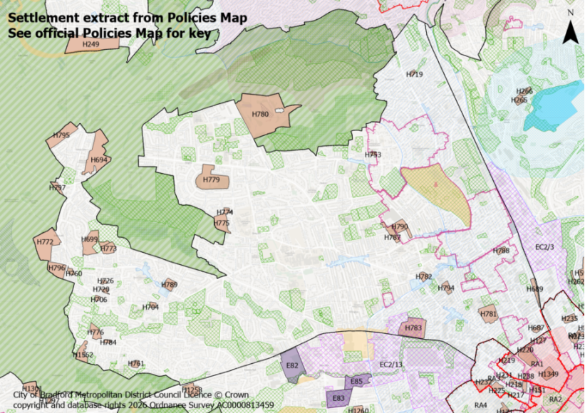
Settlement Hierarchy and Spatial Directions
- Bradford North West is defined on the policies map and forms part of the Regional City. It will support the regeneration of existing communities and the delivery of new homes and investment, focused on creating healthy, sustainable and well-connected neighbourhoods. Development will make effective use of previously developed land, strengthen local services, improve sustainable transport and green infrastructure, and respond positively to the distinctive character of individual neighbourhoods and the area’s relationship with the surrounding countryside.
- Housing growth will focus on maximising opportunities for the reuse of previously developed and under-utilised land and buildings, together with appropriate development opportunities in urban fringe areas, including land released from the Green Belt. A range of house types, sizes and tenures will be supported to broaden housing choice and meet the needs of different communities, particularly for affordable and family sized accommodation. Development will support the regeneration of existing urban areas, including the economic, environmental, physical and social transformation of key areas such as Allerton Mills, Lister Mill and Surrounds/Velvet Mill.
- Local businesses and employment will continue to be supported, including the Employment Area at Thornton Road and smaller employment locations between Manningham Lane and the railway line, as well as between City Road and Thornton Rd. Investment will support business growth and diversification, strengthen Girlington District Centre and the area’s local centres, and improve connections between communities, employment, services and facilities.
- Investment in community infrastructure will be supported to improve access to local services and facilities, particularly in neighbourhoods experiencing higher levels of deprivation. Opportunities will be supported to address identified deficiencies in open space provision, particularly natural and semi-natural greenspace, outdoor sports, parks and play provision, with priority given to areas of greatest need and poor accessibility.
Meeting Growth Needs
- Housing development in the Bradford North West will deliver approximately 3,291 dwellings through a combination of sites within the urban area and land released from the Green Belt, from sites under construction, with planning permission and new site allocations during the plan period, as set out in Table BNW 1.1
Table BNW 1.1 – Bradford North West
|
Under Construction |
Planning Permission |
Site Allocations |
|
|
Totals |
517 |
90 |
2,684 |
Deliver housing site allocations as shown on the policies map and the site proformas within section 5. Proposals for new homes within the settlement boundary on additional small sites, including the redevelopment of previously developed land, will also be supported subject to meeting policies HO3 and DS3.
- The Council will work with developers, infrastructure providers and other partners to support the coordinated delivery of housing growth across Bradford North West, ensuring that development is supported by the necessary infrastructure, services and facilities and is successfully integrated with existing communities. Delivery will also support wider regeneration objectives, including the continued transformation of Allerton Mills, Lister Mill and Surrounds/Velvet Mill.
Local Services and Facilities
- The Council will take a positive approach to retail growth and the vitality of Girlington District Centre and the designated Local Centres, through enhancing their diverse range of retail, service and leisure uses and supporting the retention and improvement of other local services and facilities.
- Development will protect and enhance existing open spaces and green and blue infrastructure and improve their accessibility and connectivity. Opportunities will be taken to strengthen key green and blue corridors, including Chellow Dean reservoirs and Chellow Dean Beck woods, Pitty Beck, Allerton and Red Beck, Heaton, Heaton Woods and Northcliffe Park, and Lister Park providing improved ecological connections and routes for walking and cycling.
- Development will support the protection and enhancement of existing sport and recreation facilities, and the provision of additional facilities where required to address identified deficiencies and improve community access.
Landscape
- Development will maintain and enhance the landscape character and setting of Bradford North West, including its distinctive wooded valleys and slopes, and respect the transition between the urban area and the Green Belt and rural landscape to the west and north west.
Historic and Natural Environment
- Development will protect and enhance designated Local Wildlife Sites, priority habitats and other areas of biodiversity value within and adjoining Bradford West, including Chellow Dean Woods and Reservoir LWS, Heaton Woods and Northcliff Park LNR/LWS.
- Development will conserve and, where appropriate, enhance the historic environment of Bradford North West, including the character and setting of the Heaton Estates, North Park Road, St Pauls, Apsley Crescent, South Field Square, Eldon Place, Whetley Grove Conservation Areas, 9 GII * Listed Buildings, 559 Grade II Listed Buildings and non-designated heritage assets.
- Residential development within the SPA/SAC Zone C (Recreational Pressure) will be required to mitigate any recreational pressure on the SPA/SAC arising from the development in accordance with the South Pennine Moors SPD and Policy NE3.
- Development in areas affected by former coal mining activity will be required to demonstrate that land stability and associated risks can be appropriately addressed. Development should also contribute to the protection and improvement of air quality, particularly in and around designated Air Quality Management Areas and other locations where air quality is a concern.
Local Infrastructure
- Development should support improvements to public transport and active travel connections within and beyond Bradford North West, including, where relevant, along Thornton Road and Allerton Rd, Toller Lane and Manningham Lane corridors and connections to Bradford City Centre to strategic employment areas such as Thornton Road and the Canal corridor.
- The Council will support development that helps to deliver the implementation of the West Yorkshire Transport Plan to secure a high-quality public transport network for the city, along with a comprehensive and attractive network for walking, wheeling and cycling, including secure cycle parking, to improve the environment for residents, businesses and visitors.
- Development will be expected to support the provision and improvement of community infrastructure required to meet the needs arising from growth, including education, healthcare and other local services and facilities.
Evidence and Studies
- Settlement Study (2026)
- Landscape Character Assessment SPD (2026)
- South Pennine Moors SPD (2022)
- Transport Assessment (2026)
- Sports Assessment (2026)
- Retail and Leisure Study (2026)
- Local Infrastructure Plan (LIP)
- Integrated Sports Assessment (2026)
Bradford North West: Site Allocations
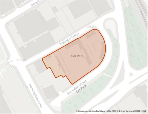
Site Size (ha) Gross: 0.49
Proposed Land Use: Housing
Minimum Development Capacity (Dwellings): 66
Site Type: PDL
Ward: City
Settlement: Bradford North West
Ownership: Private
Delivery Timescale: 2035-2040
Site Specific Requirements
Design Principles
- Development should provide at least 66 dwellings as part of a high-quality built environment in line with Policies ST4 and DS1, at a net density of 150 dph in line with HO2. This should include affordable housing (in line with Policy HO4 and an appropriate mix of dwellings in line with Policy HO3 and having due regard to relevant housing needs evidence and the character of the area).
Site Access, Highways and Transport
- An access will be required from Snowden Street. This should be designed to respond to the sites contours and to the satisfaction of the Councils Highways Officers
Natural and Historic Environment
- The site adjoins / lies within the 50m buffer of 2 listed buildings (Connaught Rooms and First Church of Christ Scientists).
- The site is identified in the LNRS with the preferred measure is T2_M04: Extend and connect tree and woodland cover across the White Rose Forest area in West Yorkshire to contribute to base target of 16.5 per cent and stretched target of 18.5 per cent by 2050 using 'right tree, right place' principles.
Environmental Protection
- The site is within a Clean Air Zone and adjoins Manningham Lane and Hamm Strasse where NO2 levels = 30 parts per million (plus). Development must be in accordance with the requirements set out in Policy CR1.
- Site is within a Mineral Safeguarding Area (MSA) for Coal. A mineral resource assessment will be required as part of any planning application to determine the extent and availability of any mineral resources.
Open Space and Green / Blue Infrastructure
- Open space should be provided in line with Policy NE2, having regards to the standards set out Appendix 10.
- The site lies within the Bradford City Centre Opportunity Area, as identified in the Green and Blue Infrastructure Strategy (GBIS). The strategy should be consulted to identify opportunities for incorporating measures within the development that enhance the quality of, and connectivity to, the green and blue infrastructure network in this area.
- Site is partially within an area of low provision and high need for green and blue infrastructure. Development proposals should focus on carefully designed green and blue infrastructure to contribute towards site specific issues e.g. flood mitigation, urban cooling, etc.
Infrastructure Requirements
- Proportionate contributions to community infrastructure will be required, where appropriate, in line with Policies ID1 and ID2, and having regard to the Local Infrastructure Plan.
H689: Midland Road Comment
Site Boundary
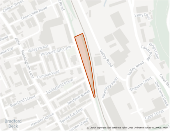
Site Size (ha) Gross: 1.00
Proposed Land Use: Housing
Minimum Development Capacity (Dwellings): 67
Site Type: PDL
Ward: Manningham
Settlement: Bradford North West
Ownership: Private
Delivery Timescale: 2030-2035
Site Specific Requirements
Design Principles
- Development should provide at least 67 dwellings as part of a high-quality built environment in line with Policies ST4 and DS1, at a net density of 75 dph in line with Policy HO2. This should include affordable housing (in line with Policy HO4 and an appropriate mix of dwellings in line with Policy HO3 and having due regard to relevant housing needs evidence and the character of the area).
Site Access, Highways and Transport
- A site access will be required from Midland Road. This should be designed to respond to the sites contours and to the satisfaction of the Councils Highways Officers
Flooding, Water and Drainage
- Development should be directed away from areas with significant level of surface water risk.
Natural and Historic Environment
- A small part of the site area to the north lies within a bat alert area. Ecology survey may be required at the planning application stage. Early engagement with the Council's Biodiversity Officer is recommended.
- The site is identified in the LNRS with the preferred measureB3_M02: Enhance (rather than replace) existing habitats on some areas of brownfield so they become high-quality, diverse, wildlife-rich spaces or urban parks (taking site allocations into account). This will help species that rely on brownfield habitats, such as the dingy skipper. Allow significant areas to develop naturally.
- The site is located within a bat alert area. An ecological survey will be required as part of any planning application to establish the extent/impacts as well as to identify appropriate mitigation.
Environmental Protection
- Site is located within the Clean Air Zone. Development must be in accordance with the requirements set out in Policy CR1
- The northern part of (circa 1/3) the site contains a former landfill site (ref 13se43) for which the waste type is described as 'inert, clean, uncontaminated’. It also adjoins a former landfill site (i.e. for inert demolition) on its northern border and falls within a 150m buffer zone of this. It was previously granted permission for the filling of a dry dam alongside Midland Road (90/2/07692), which was subject to the unauthorised deposit of demolition waste in 1993 and was then granted planning permission to continue to deposit inert waste until 1996 (94/01818/FUL). A Land Contamination Assessment – Phase 1 Report will be required as part of any planning application.
Open Space and Green / Blue Infrastructure
- Open space should be provided in line with Policy NE2, having regards to the standards set out Appendix 10.
- The site lies within the Bradford City Centre Opportunity Area, as identified in the Green and Blue Infrastructure Strategy (GBIS). The strategy should be consulted to identify opportunities for incorporating measures within the development that enhance the quality of, and connectivity to, the green and blue infrastructure network in this area.
- Site is partially within an area of medium provision and high need for green and blue infrastructure. Development proposals should focus on carefully designed green and blue infrastructure to contribute towards site specific issues e.g. flood mitigation, urban cooling, etc.
Infrastructure Requirements
- Proportionate contributions to community infrastructure will be required, where appropriate, in line with Policies ID1 and ID2, and having regard to the Local Infrastructure Plan.
H694: Haworth Road, Sandy Lane Comment
Site Boundary
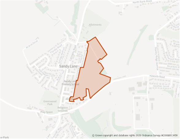
Site Size (ha) Gross: 7.37
Proposed Land Use: Housing
Minimum Development Capacity (Dwellings): 155
Site Type: Greenfield
Ward: Thornton & Allerton
Settlement: Bradford North West
Ownership: Private
Delivery Timescale: Short 2025- 2030 (1-5)
Site Specific Requirements
Design Principles
- Development should provide at least 155 dwellings as part of a high-quality built environment in line with Policies ST4 and DS1, at a net density of 35 dph in line with Policy HO2. This should include affordable housing (in line with Policy HO4) and an appropriate mix of dwellings (in line with Policy HO3 and having due regard to relevant housing needs, evidence and the character of the area).
- A sensitive design and layout will be required taking into consideration the site’s location on the edge of the settlement and its sloping nature. This should include appropriate landscaping in line with Policy DS2 and on site open space and seek to avoid areas that are at risk of fluvial and surface water flooding toward the northern end of the site.
Site Access, Highways and Transport
- A new access will be required from Haworth Road. This should be designed to respond to the sites contours and to the satisfaction of the Councils Highways Officers
Flooding, Water and Drainage
- The site contains some areas surafce water flood risk. The development of the site should ensure steps are taken to mitigate the risk of flooding in the future through on site SuDs the design of which should be discussed and agreed with the lead Local Flood Authority (City of Bradford MDC) and the Environment Agency at the planning stage.
Natural and Historic Environment
- The site’s eastern boundary is located within close proximity to grade II listed buildings, off Haworth Road and Cottingley Road. Development heights should not exceed two or three storeys in height, to ensure no impacts on the significance or setting of the nearby heritage assets.
- The site is located within a bat alert area. An ecological survey will be required as part of any planning application to establish the extent/impacts as well as to identify appropriate mitigation.
- The site should provide new habitat areas to help to significantly boost biodiversity in the area. This should be facilitated by new tree planting and landscaping, containing native species with natural margins to encourage biodiversity and provide new habitats for birds, mammals and invertebrates.
Environmental Protection
- Site is partially within a Development High Risk Area for coal mining (circa 1/3 of its area to north and small part to the east), indicating that it contains one or more recorded former related features at surface or shallow depth. Mapping indicates Probable Shallow Coal Mine Workings, but not presence of any suspected mine entry shafts. A Coal Mining Risk Assessment (CMRA) will be required as part of any planning application.
- Site is partly within 150m and 250m buffer of a former landfill site (north). A Land Contamination Assessment – Phase 1 Report will be required as part of an application.
Open Space and Green / Blue Infrastructure
- Open space should be provided in line with Policy NE2, having regards to the standards set out Appendix 11.
- Site is partially within an area of low provision and high need for green and blue infrastructure. Development proposals should focus on carefully designed green and blue infrastructure to contribute towards site specific issues e.g. flood mitigation, urban cooling, etc.
Landscape
- The site is located within the Cottingley Urban Edge Wooded Valleys and Slopes Landscape Character area/type (H1).
- The southeastern part the site is most sensitive to change due to steeper and more open and elevated landform than lower down the valley to the north and west. By avoiding development on the more elevated, steeper valleys sides, development would be more in keeping with the settlement pattern lower in the valley. Development in lower lying parts of the site could positively integrate the existing abrupt edge of the settlement with sensitive siting / layout of development and tree planting.
Green Belt (and Golden Rules)
- Site has been removed from the Green Belt. Development on the site should be consistent with the “Golden Rules” set out in the NPPF in relation to affordable housing, necessary improvements to infrastructure and accessible green space provision.
Infrastructure Requirements
- Proportionate contributions to community infrastructure will be required, where appropriate, in line with Policies ID1 and ID2, and having regard to the Local Infrastructure Plan.
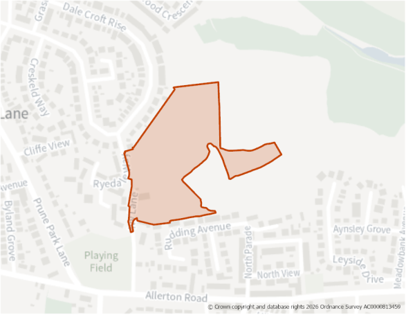
Site Size (ha) Gross: 3.76
Proposed Land Use: Housing
Minimum Development Capacity (Dwellings): 99
Site Type: Greenfield
Ward: Thornton & Allerton
Settlement: Bradford North West
Ownership: Private
Delivery Timescale: Medium 2030-2035 (6-10)
Site Specific Requirements
Design Principles
- Development should provide at least 99 dwellings as part of a high-quality built environment in line with Policies ST4 and DS1, at a net density of 35 dph in line with Policy HO2. This should include affordable housing (in line with Policy HO4) and an appropriate mix of dwellings (in line with Policy HO3 and having due regard to relevant housing needs, evidence and the character of the area).
- A sensitive design and layout will be required taking into consideration the site’s location on the edge of the settlement. This should include appropriate landscaping and seeking to avoid areas that are at risk of fluvial and surface water flooding. Consideration should be given to the development of the site alongside H773 to ensure a comprehensive scheme is delivered
Site Access, Highways and Transport
- The existing access from Ivy Lane will either need to be improved or an alternate option identified such as Ryedale Way. Any proposals should be discussed with the Councils HIghways Officers at an early stage.
Flooding, Water and Drainage
- The proposed development would see a change in the risk classification from less vulnerable to more vulnerable, according to the NPPF. Given the change in use and therefore vulnerability of the site, the FRA must show that the development can be designed to be safe and that there is adequate emergency planning provision (para 014 FRCC-PPG).
- Topographic flow routes and depressions should be considered and included in site design and ideally left in place to flood naturally when required. Any regrading of land must include for like for like volumes to ensure risk is contained safely onsite for the lifetime of development.
Natural and Historic Environment
- The site lies within Zone C (Recreational Pressure) of the Special Protection Area (SPA). Residential development resulting in a net increase in dwellings will be required to mitigate any recreational pressure on the SPA caused by such development in accordance with the South Pennine Moors SPD and Policy NE3.
- The sites southern boundary is located within proximity to a Local Wildlife Site (Chellow Dean Woods and Reservoir) and semi improved acid grassland adjoins the north eastern boundary. The northern and eastern part of the site falls within a bat alert area. An Ecology survey may be required at the planning application stage. Early engagement with the Council's Biodiversity Officer is recommended.
- A single Tree Preservation Order (TPO) lies at the boundary of the site in it's eastern segment which should be retained and incorporated within any scheme. Additional new trees should be provided throughout the site. Development should be informed by an arboricultural assessment
- The site is located within a bat alert area. An ecological survey will be required as part of any planning application to establish the extent/impacts as well as to identify appropriate mitigation.
Environmental Protection
- Site is partly within 150m and 250m buffer of a former landfill site (ref 13sw03) which adjoins it to the north west. It also has a history of mineral extraction and processing from a former quarry. A Land Contamination Assessment – Phase 1 Report will be required to assess potential contamination risks, as part of an application.
- All of the site area is within a Mineral Safeguarding Area (coal, sand and gravel). A mineral resource assessment will be required as part of any planning application to determine the extent and availability of any mineral resources.
Open Space and Green / Blue Infrastructure
- Open space should be provided in line with Policy NE2, having regards to the standards set out Appendix 11.
- Site is partially within an area of low provision and medium need for green and blue infrastructure. Development proposals should focus on carefully designed green and blue infrastructure to contribute towards site specific issues e.g. flood mitigation, urban cooling etc.
Infrastructure Requirements
- Proportionate contributions to community infrastructure will be required, where appropriate, in line with Policies ID1 and ID2, and having regard to the Local Infrastructure Plan.
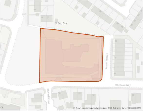
Site Size (ha) Gross: 0.36
Proposed Land Use: Housing
Minimum Development Capacity (Dwellings): 16
Site Type: PDL
Ward: Thornton & Allerton
Settlement: Bradford North West
Ownership: Private
Delivery Timescale: Medium 2030-2035 (6-10)
Site Specific Requirements
Design Principles
- Development should provide at least 16 dwellings as part of a high-quality built environment in line with Policies ST4 and DS1, at a net density of 50 dph in line with Policy HO2. This should include affordable housing (in line with Policy HO4) and an appropriate mix of dwellings (in line with Policy HO3 and having due regard to relevant housing needs, evidence and the character of the area).
Site Access, Highways and Transport
- Access from Whitburn Way and Avenel Terrace
Flooding, Water and Drainage
- The proposed development would see a change in the risk classification from less vulnerable to more vulnerable, according to the NPPF. Given the change in use and therefore vulnerability of the site, the FRA must show that the development can be designed to be safe and that there is adequate emergency planning provision (para 014 FRCC-PPG).
Natural and Historic Environment
- The site lies within Zone C (Recreational Pressure) of the Special Protection Area (SPA). Residential development resulting in a net increase in dwellings will be required to mitigate any recreational pressure on the SPA caused by such development in accordance with the South Pennine Moors SPD and Policy NE3.
Environmental Protection
- All of the site area is within a Mineral Safeguarding Area (coal, sand). A mineral resource assessment will be required as part of any planning application to determine the extent and availability of any mineral resources.
Open Space and Green / Blue Infrastructure
- Open space should be provided in line with Policy NE2, having regards to the standards set out Appendix 11.
- The site is partially within an area of medium provision and high need for green and blue infrastructure. Development proposals should focus on carefully designed green and blue infrastructure to contribute towards site specific issues e.g. flood mitigation, urban cooling etc.
Infrastructure Requirements
- Proportionate contributions to community infrastructure will be required, where appropriate, in line with Policies ID1 and ID2, and having regard to the Local Infrastructure Plan.
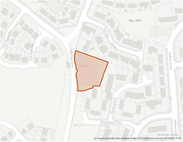
Site Size (ha) Gross: 0.26
Proposed Land Use: Housing
Minimum Development Capacity (Dwellings): 13
Site Type: PDL
Ward: Thornton & Allerton
Settlement: Bradford North West
Ownership: Private
Delivery Timescale: Short 2025- 2030 (1-5)
Site Specific Requirements
Design Principles
- Development should provide 13 dwellings as part of a high-quality built environment in line with Policies ST4 and DS1, at a net density of 50 dph in line with Policy HO2. This should include affordable housing (in line with Policy HO4) and an appropriate mix of dwellings (in line with Policy HO3 and having due regard to relevant housing needs, evidence and the character of the area).
Site Access, Highways and Transport
- A new access would be required from Allerton Lane.
Natural and Historic Environment
- The site lies within Zone C (Recreational Pressure) – Residential development resulting in a net increase in dwellings will be required to mitigate any recreational pressure on the SPA/SAC caused by such development in accordance with the South Pennine Moors SPD and Policy NE3.
- The northern part of the site area lies within the 50m buffer of a Grade II Listed building.
Open Space and Green / Blue Infrastructure
- Open space should be provided in line with Policy NE2, having regards to the standards set out Appendix 11.
- Site is partially within an area of low provision and high need for green and blue infrastructure. Development proposals should consider whether carefully designed green infrastructure can be provided to link to adjacent areas particularly those on neighbouring land to the west.
Infrastructure Requirements
- Proportionate contributions to community infrastructure will be required, where appropriate, in line with Policies ID1 and ID2, and having regard to the Local Infrastructure Plan.
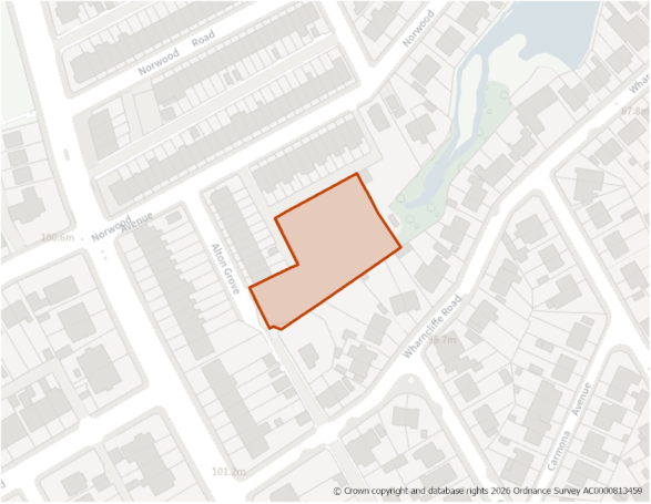
Site Size (ha) Gross: 0.26
Proposed Land Use: Housing
Minimum Development Capacity (Dwellings): 13
Site Type: PDL
Ward: Shipley
Settlement: Bradford North West
Ownership: Private
Delivery Timescale: Long 2035+ (11+)
Site Specific Requirements
Design Principles
- Development should provide at least 13 dwellings as part of a high-quality built environment in line with Policies ST4 and DS1, at a net density of 50 dph in line with Policy HO2. This should include affordable housing (in line with Policy HO4) and an appropriate mix of dwellings (in line with Policy HO3 and having due regard to relevant housing needs, evidence and the character of the area).
Site Access, Highways and Transport
- A new access will be required from Alton Grove.
Natural and Historic Environment
- The site lies within Zone C (Recreational Pressure) - Residential development resulting in a net increase in dwellings will be required to mitigate any recreational pressure on the SPA/SAC caused by such development in accordance with the South Pennine Moors SPD and Policy NE3.
- The site lies within a bat alert area and adjoins an area identified as wetland habitat network (Old Mill Pond). It is also covered by a designated woodland TPO. Development should be informed by an arboricultural assessmen and an Ecology survey may be required at the planning application stage. Early engagement with the Council's Biodiversity Officer is recommended.
- The site is identified in the LNRS with the preferred measureW2_M02: Make more space in water for plants and animals that live there.
Environmental protection
- This site is located within the Clean Air Zone and development must be in accordance with the requirements set out in Policy CR1
Open Space and Green / Blue Infrastructure
- Open space should be provided in line with Policy NE2, having regards to the standards set out Appendix 11.
- Site is within an area of medium provision and high need for green and blue infrastructure. Development proposals should focus on carefully designed green and blue infrastructure to contribute towards site specific issues e.g. flood mitigation, urban cooling etc with linkages to the natural area to the north east of the site
Infrastructure Requirements
- Proportionate contributions to community infrastructure will be required, where appropriate, in line with Policies ID1 and ID2, and having regard to the Local Infrastructure Plan.
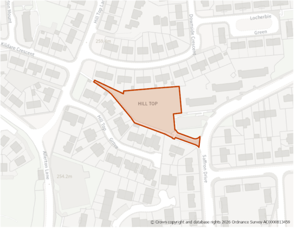
Site Size (ha) Gross: 0.27
Proposed Land Use: Housing
Minimum Development Capacity (Dwellings): 14
Site Type: Greenfield
Ward: Thornton & Allerton
Settlement: Bradford North West
Ownership: Private
Delivery Timescale: Long 2035+ (11+)
Site Specific Requirements
Design Principles
- Development should provide at least 14 dwellings as part of a high-quality built environment in line with Policies ST4 and DS1, at a net density of 50 dph in line with Policy HO2. This should include affordable housing (in line with Policy HO4) and an appropriate mix of dwellings (in line with Policy HO3 and having due regard to relevant housing needs, evidence and the character of the area).
Site Access, Highways and Transport
- Site access from Saffron Drive.
- The public footpath through the site linking Saffron Drive and Hill Top Lane should be maintained
Natural and Historic Environment
- The site lies within Zone C (Recreational Pressure) - Residential development resulting in a net increase in dwellings will be required to mitigate any recreational pressure on the SPA/SAC caused by such development in accordance with the South Pennine Moors SPD and Policy NE3.
- The western edge of the site lies within a 50m buffer of Grade II listed building (25/645).
Open Space and Green / Blue Infrastructure
- The site is within an area of low provision and high need for green and blue infrastructure. Development proposals should focus on carefully designed green and blue infrastructure with links to neighbouring areas.
Infrastructure Requirements
- Proportionate contributions to community infrastructure will be required, where appropriate, in line with Policies ID1 and ID2, and having regard to the Local Infrastructure Plan.
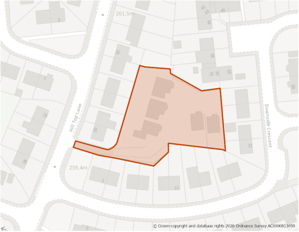
Site Size (ha) Gross: 0.21
Proposed Land Use: Housing
Minimum Development Capacity (Dwellings): 5
Site Type: PDL
Ward: Thornton & Allerton
Settlement: Bradford North West
Ownership: Private
Delivery Timescale: Short (2025-2030) 1-5
Site Specific Requirements
The site has planning permission and is under construction as indicated on the site plan.
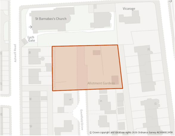
Site Size (ha) Gross: 0.23
Proposed Land Use: Housing
Minimum Development Capacity (Dwellings): 12
Site Type: Greenfield
Ward: Heaton & Frizinghall
Settlement: Bradford North West
Ownership: Private
Delivery Timescale: Long 2035+ (11+)
Site Specific Requirements
Design Principles
- Development should provide 12 dwellings as part of a high-quality built environment in line with Policies ST4 and DS1, at a net density of 50 dph in line with Policy HO2. This should include affordable housing (in line with Policy HO4) and an appropriate mix of dwellings (in line with Policy HO3 and having due regard to relevant housing needs, evidence and the character of the area).
- New trees should be planted on site as part of the development together with additional high qaulity landscaping and open space where possible
Natural and Historic Environment
- The site lies within Zone C (Recreational Pressure) – Residential development resulting in a net increase in dwellings will be required to mitigate any recreational pressure on the SPA/SAC caused by such development in accordance with the South Pennine Moors SPD and Policy NE3.
- There are several single Tree TPO's that lie just to the north of the site and their 15m buffer zones encroach into its area. The site layout will need to have regard to this. Development should be informed by an arboricultural assessment
- The site adjoins the Heaton Estates Conservation Area on its northern and eastern boundaries. It lies within the 50m buffer for Grade II Listed St Barnabas Church ref 22/227.
Environmental protection
- The Site is within the 150m buffer or 250m buffer of a former landfill to the east and west of it. A Land Contamination Assessment – Phase 1 Report will be required as part of any planning application.
Open Space and Green / Blue Infrastructure
- Site is partially within an area of low provision and high need for green and blue infrastructure. Development proposals should focus on carefully designed green and blue infrastructure to contribute towards site specific issues e.g. flood mitigation, urban cooling, etc.
Infrastructure Requirements
- Proportionate contributions to community infrastructure will be required, where appropriate, in line with Policies ID1 and ID2, and having regard to the Local Infrastructure Plan.
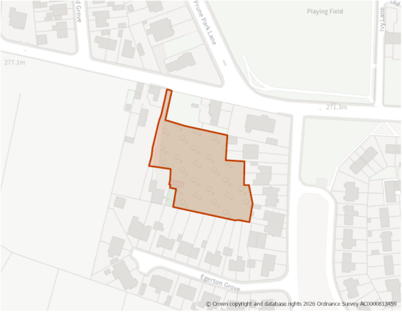
Site Size (ha) Gross: 0.41
Proposed Land Use: Housing
Minimum Development Capacity (Dwellings): 13
Site Type: Greenfield
Ward: Thornton & Allerton
Settlement: Bradford North West
Ownership: Private
Delivery Timescale: Medium 2030-2035 (6-10)
Site Specific Requirements
Design Principles
- Development should provide a minumum of 13 dwellings as part of a high-quality built environment in line with Policies ST4 and DS1, at a net density of 35 dph in line with Policy HO2. This should include affordable housing (in line with Policy HO4) and an appropriate mix of dwellings (in line with Policy HO3 and having due regard to relevant housing needs, evidence and the character of the area).
Site Access, Highways and Transport
- A new access should be created from Allerton Road which will need to be wider than the current provision to the satifaction of the Councils Highways Officers.
Natural and Historic Environment
- The site lies within Zone C (Recreational Pressure) - Residential development resulting in a net increase in dwellings will be required to mitigate any recreational pressure on the SPA/SAC caused by such development in accordance with the South Pennine Moors SPD and Policy NE3.
- The site is identified in the LNRS with the preferred measureB1_M02: Significantly boost the biodiversity and resilience of existing urban wooded areas, prioritising those with the fewest species and within areas of greatest social deprivation; improve the age structure and function of woodland by encouraging natural regeneration and planting of younger trees and ground flora.
Open Space and Green / Blue Infrastructure
- Open space should be provided in line with Policy NE2, having regards to the standards set out Appendix 11.
- Site is within an area of low provision and medium need for green and blue infrastructure. Development proposals should focus on carefully designed green and blue infrastructure to contribute towards site specific issues e.g. flood mitigation, urban cooling, etc.
Infrastructure Requirements
- Proportionate contributions to community infrastructure will be required, where appropriate, in line with Policies ID1 and ID2, and having regard to the Local Infrastructure Plan.
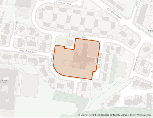
Site Size (ha) Gross: 0.59
Proposed Land Use: Housing
Minimum Development Capacity (Dwellings): 19
Site Type: PDL
Ward: Thornton & Allerton
Settlement: Bradford North West
Ownership: Private
Delivery Timescale: Long 2035+ (11+)
Site Specific Requirements
Design Principles
- Development should provide at least 19 dwellings as part of a high-quality built environment in line with Policies ST4 and DS1, at a net density of 35 dph in line with Policy HO2. This should include affordable housing (in line with Policy HO4) and an appropriate mix of dwellings (in line with Policy HO3 and having due regard to relevant housing needs, evidence and the character of the area).
- Development should front the current highways to align with the existing development already present on surrounding streets with new street/fron garden trees being provided where possible
Site Access, Highways and Transport
- Existing access roads should be used.
Natural and Historic Environment
- The site lies within Zone C (Recreational Pressure) - Residential development resulting in a net increase in dwellings will be required to mitigate any recreational pressure on the SPA/SAC caused by such development in accordance with the South Pennine Moors SPD and Policy NE3.
- Part of the south eastern area of the site lies within a bat alert area. Ecology survey may be required at the planning application stage. Early engagement with the Council's Biodiversity Officer is recommended.
- The site is located within a bat alert area. An ecological survey will be required as part of any planning application to establish the extent/impacts as well as to identify appropriate mitigation.
Open Space and Green / Blue Infrastructure
- Open space should be provided in line with Policy NE2, having regards to the standards set out Appendix 11.
- Site is partially within an area of medium provision and high need for green and blue infrastructure. Development proposals should focus on carefully designed green and blue infrastructure to contribute towards site specific issues e.g. flood mitigation, urban cooling, etc.
Infrastructure Requirements
- Proportionate contributions to community infrastructure will be required, where appropriate, in line with Policies ID1 and ID2, and having regard to the Local Infrastructure Plan.
H772: Allerton Road, Prune Park Lane, Allerton Comment
Site Boundary
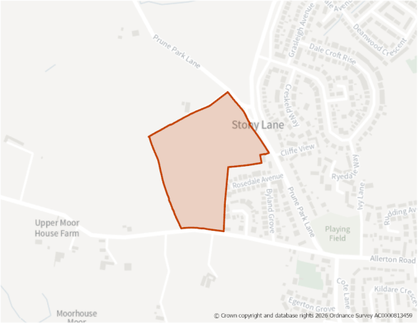
Site Size (ha) Gross: 6.16
Proposed Land Use: Housing
Minimum Development Capacity (Dwellings): 162
Site Type: Greenfield
Ward: Thornton & Allerton
Settlement: Bradford North West
Ownership: Private
Delivery Timescale: Long 2035+ (11+)
Site Specific Requirements
Design Principles
- Development should provide at least 162 dwellings as part of a high-quality built environment in line with Policies ST4 and DS1, at a net density of 35 dph in line with Policy HO2. This should include affordable housing (in line with Policy HO4) and an appropriate mix of dwellings (in line with Policy HO3 and having due regard to relevant housing needs, evidence and the character of the area).
- The development should ensure a well designed site with particular care taken of the the aspect facing north and east. It should include appropriate landscaping and open space with careful treatment of the site boundary to the west and north to ensure a new strong edge to the built up area.
Site Access, Highways and Transport
- A new access will be required from Allerton Road with secondary access from Prune Park Lane.
Flooding, Water and Drainage
- The proposed development would see a change in the risk classification from less vulnerable to more vulnerable, according to the NPPF. Given the change in use and therefore vulnerability of the site, the FRA must show that the development can be designed to be safe and that there is adequate emergency planning provision (para 014 FRCC-PPG).
Natural and Historic Environment
- The site lies within Zone C (Recreational Pressure) - Residential development resulting in a net increase in dwellings will be required to mitigate any recreational pressure on the SPA/SAC caused by such development in accordance with the South Pennine Moors SPD and Policy NE3.
- The north field is a unmanaged grassland with wildflowers that is important for nesting birds. An appropiate part of site should be retained and enhanced for its biodiversity net gain.Paths could be included within the design to provide access, but it should be clear it a grassland habitat and not a general open space. All of site should achieve a biodiversity net gain of 10% gain, under an agreed Management Plan.
- A large part of the site area is within grade 3b agricultural land, except for small parts to nort and east that are within grade 4 land.
- A Heritage Impact Assessment has been undertaken for this site and no impacts were identified.
Environmental protection
- A former landfill area covers the majority of the part of the site (3/4) and the remainder of the it lies within a 150m buffer of this and another landfill area to the north west. A Land Contamination Assessment – Phase 1 Report will be required as part of any planning application.
- A small part of site is within a Development High Risk Area for coal mining near the eastern boundary due to a possible mining entry. A Coal Mining Risk Assessment (CMRA) will be required as part of any planning application.
- The whole site is within a Minerals Safeguarding Area (Coal) and majority for Sandstone. A mineral resource assessment will be required as part of any planning application to determine the extent and availability of any sandstone resource.
Open Space and Green / Blue Infrastructure
- Open space should be provided in line with Policy NE2, having regards to the standards set out Appendix 11.
- Site is partially within an area of low provision and high need for green and blue infrastructure. Development proposals should focus on carefully designed green and blue infrastructure to contribute towards site specific issues e.g. flood mitigation, urban cooling, etc.
Landscape
- The site is located within the Thornton, Queensbury and Wilsden Mixed Upland Pasture Landscape Character area/type (E1).
- There are opportunities to sensitively integrate limited development (into the landform and with appropriate vegetation) and soften the settlement edge. It is recommended that any development be restricted to land adjacent to existing properties at southern end of Stony Lane to retain historic field patterns and separation from nearby farmsteads. Utilise landform and vegetation to integrate new development into the landscape. Retain dry stone walls where possible.
Green Belt (and Golden Rules)
- Site has been removed from the Green Belt. Development on the site should be consistent with the “Golden Rules” set out in the NPPF in relation to affordable housing, necessary improvements to infrastructure and accessible green space provision.
Infrastructure Requirements
- Proportionate contributions to community infrastructure will be required, where appropriate, in line with Policies ID1 and ID2, and having regard to the Local Infrastructure Plan.
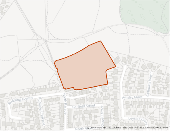
Site Size (ha) Gross: 1.42
Proposed Land Use: Housing
Minimum Development Capacity (Dwellings): 45
Site Type: Greenfield
Ward: Thornton & Allerton
Settlement: Bradford North West
Ownership: Public
Delivery Timescale: Medium 2030-2035 (6-10)
Site Specific Requirements
Design Principles
- Development should provide at least 45 dwellings as part of a high-quality built environment in line with Policies ST4 and DS1, at a net density of 35 dph in line with Policy HO2. This should include affordable housing (in line with Policy HO4) and an appropriate mix of dwellings (in line with Policy HO3 and having due regard to relevant housing needs, evidence and the character of the area).
- A sensitive design and layout will be required taking into consideration the site’s location on the edge of the settlement. This should include appropriate landscaping which links closely to adjacent area of open space to the north, planted with native species to provide a habitat for birds, mammals and invertebrates.
- Consideration should be given to a comprehensive development of the site alongside H699 with linked open space and footpath connectivity.
Site Access, Highways and Transport
- Access should be taken from the north provided for site H699 with linked footpaths through both sites for pedestrians and cyclists.
Flooding, Water and Drainage
- The proposed development would see a change in the risk classification from less vulnerable to more vulnerable, according to the NPPF. Given the change in use and therefore vulnerability of the site, the FRA must show that the development can be designed to be safe and that there is adequate emergency planning provision (para 014 FRCC-PPG).
- Topographic flow routes should be considered and included in site design and ideally left in place to flood naturally when required. Any regrading of land must include for like for like volumes to ensure risk is contained safely onsite for the lifetime of development.
Natural and Historic Environment
- The site lies within Zone C (Recreational Pressure) - Residential development resulting in a net increase in dwellings will be required to mitigate any recreational pressure on the SPA/SAC caused by such development in accordance with the South Pennine Moors SPD and Policy NE3.
- The south western part of site lies within a bat alert area. An Ecology Survey will likely be required at planning stage. Early engagement with the Council’s Biodiversity Officer is recommended.
- A single TPO lies on the northern boundary and should be retained.
- The southern half of the site is classified as urban land and the norhern section is grade 4.
Environmental protection
- The site lies within the 150m buffer of a former landfill area that adjoins its northern boundary. A Land Contamination Assessment – Phase 1 Report will be required as part of any planning application.
- All of the site is within a Minerals Safeguarding Area (Coal) and a small part for Sandstone. A mineral resource assessment will be required as part of any planning application to determine the extent and availability of any sandstone resource.
Open Space and Green / Blue Infrastructure
- Open space should be provided in line with Policy NE2, having regards to the standards set out Appendix 11.
- Site is partially within an area of low provision and medium need for green and blue infrastructure. Development proposals should focus on carefully designed green and blue infrastructure to contribute towards site specific issues e.g. flood mitigation, urban cooling, etc.
Infrastructure Requirements
- Proportionate contributions to community infrastructure will be required, where appropriate, in line with Policies ID1 and ID2, and having regard to the Local Infrastructure Plan.
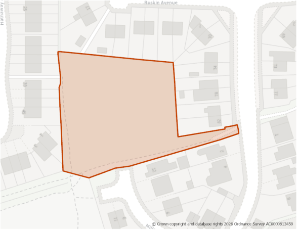
Site Size (ha) Gross: 0.37
Proposed Land Use: Housing
Minimum Development Capacity (Dwellings): 19
Site Type: Greenfield
Ward: Heaton & Frizinghall
Settlement: Bradford North West
Ownership: Private
Delivery Timescale: Long 2035+ (11+)
Site Specific Requirements
Design Principles
- Development should provide at least 19 dwellings as part of a high-quality built environment in line with Policies ST4 and DS1, at a net density of 50 dph in line with Policy HO2. This should include affordable housing (in line with Policy HO4) and an appropriate mix of dwellings (in line with Policy HO3 and having due regard to relevant housing needs, evidence and the character of the area). Consideration could be given to the development of the site alongside H775 with shared access and open space provision
- The public footpath through the southern section of the site should be retained and enhanced together with the footpath to the west side of the site and link to Ruskin Avenue.
Site Access, Highways and Transport
- Site access from existing road or where possible from a new access provided via H775.
Natural and Historic Environment
- The site lies within Zone C (Recreational Pressure) - Residential development resulting in a net increase in dwellings will be required to mitigate any recreational pressure on the SPA/SAC caused by such development in accordance with the South Pennine Moors SPD and Policy NE3.
- Site contains a poor unmanaged rich grass land and a Bramble scrub that is providing a breeding habitat for white throats. Proposals should provide; species rich grassland along the footpaths to the west and south; a hedgerow to the west along close boarded fence and retain the Oak tree within its areas as part of a open space.
- Site falls within Grade 4 agricultural land.
- The site is identified in the LNRS with the preferred measureGI_M03: Restore and enhance existing species-rich grasslands.
Open Space and Green / Blue Infrastructure
- Open space should be provided in line with Policy NE2, having regards to the standards set out Appendix 11.
- Site is within an area of low provision and medium need for green and blue infrastructure. Development proposals should focus on carefully designed green and blue infrastructure to contribute towards site specific issues e.g. flood mitigation, urban cooling, etc.
Landscape
- The site is located within the Cottingley Urban Edge Wooded Valleys and Slopes Landscape Character area/type (H1). No landscape sensitivity assessment was undertaken for this site. Consideration should be given to the guidance set out in the Landscape Character Assessment SPD.
Infrastructure Requirements
- Proportionate contributions to community infrastructure will be required, where appropriate, in line with Policies ID1 and ID2, and having regard to the Local Infrastructure Plan.
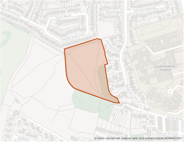
Site Size (ha) Gross: 2.35
Proposed Land Use: Housing
Minimum Development Capacity (Dwellings): 88
Site Type: Greenfield
Ward: Heaton & Frizinghall
Settlement: Bradford North West
Ownership: Private
Delivery Timescale: Long 2035+ (11+)
Site Specific Requirements
Design Principles
- Development should provide at least 88 dwellings as part of a high-quality built environment in line with Policies ST4 and DS1, at a net density of 35 dph in line with Policy HO2. This should include affordable housing (in line with Policy HO4) and an appropriate mix of dwellings (in line with Policy HO3 and having due regard to relevant housing needs, evidence and the character of the area).
- A sensitive design and layout will be required taking into consideration the site’s location on the edge of the settlement. It should respond to the sloping nature of the site and provide areas of landscaping, open space and new trees. The development design should consider whether site H774 can be developed alongside the site to provide a comprehensive scheme which acknowledges footpath routes and open space areas together with shared access.
- Landscaping proposals should provide opportunities for improvements in biodiversity and provide shelter for birds, mammals and invertebrates.
Site Access, Highways and Transport
- Site access from Millmoor Close together with a secondary access from the south. Access will need to be discussed with the Councils Highways Officers at an early stage.
Natural and Historic Environment
- The site lies within Zone C (Recreational Pressure) - Residential development resulting in a net increase in dwellings will be required to mitigate any recreational pressure on the SPA/SAC caused by such development in accordance with the South Pennine Moors SPD and Policy NE3.
- The southern part of site adjoins an area identified as priority habitat - deciduous woodland and its eastern edge may contain an area of priority woodland that should be retained. Proposals should provide; enhanced grassland habitats along the PROW’s; a an open space with native species rich grassland and sparsely planted locally native trees to provide shade. A full ecological survey may be required.
- A large part of the site area is within grade 4, except for the southern fringe that is urban land.
- The site is identified in the LNRS with the preferred measureGI_M03 Restore and enhance existing species-rich grasslands.
Environmental protection
- The whole site is within a Minerals Safeguarding Area (Coal) and majority for Sandstone.A mineral resource assessment will be required as part of any planning application to determine the extent and availability of any sandstone resource.
Open Space and Green / Blue Infrastructure
- Open space should be provided in line with Policy NE2, having regards to the standards set out Appendix 11.
- Site is within an area of medium provision and high need for green and blue infrastructure. Development proposals should focus on carefully designed green and blue infrastructure to contribute towards site specific issues e.g. flood mitigation, urban cooling, etc.
Landscape
- The site is located within the Cottingley Urban Edge Wooded Valleys and Slopes Landscape Character area/type (H1).
- Any development within the upper part of the site should carefully consider effects on the skyline and also take opportunities to soften the edge of the settlement. Avoiding development on the open and also more vegetated steep valleys sides would have less direct impact on valued elements.
Green Belt (and Golden Rules)
- Site has been removed from the Green Belt. Development on the site should be consistent with the “Golden Rules” set out in the NPPF in relation to affordable housing, necessary improvements to infrastructure and accessible green space provision.
Infrastructure Requirements
- Proportionate contributions to community infrastructure will be required, where appropriate, in line with Policies ID1 and ID2, and having regard to the Local Infrastructure Plan.
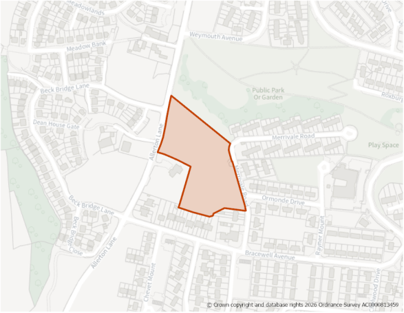
Site Size (ha) Gross: 1.31
Proposed Land Use: Housing
Minimum Development Capacity (Dwellings): 41
Site Type: Greenfield
Ward: Thornton & Allerton
Settlement: Bradford North West
Ownership: Public
Delivery Timescale: Medium 2030-2035 (6-10)
Site Specific Requirements
Design Principles
- Development should provide at least 41 dwellings as part of a high-quality built environment in line with Policies ST4 and DS1, at a net density of 35 dph in line with Policy HO2. This should include affordable housing (in line with Policy HO4) and an appropriate mix of dwellings (in line with Policy HO3 and having due regard to relevant housing needs, evidence and the character of the area).
- The of the site should respond to the sloping nature of the site and provide suitable landscaping which links the site with the neighbouring urban park to the north of the site together with maintaining and providing pedestrian linkages to this area and out to the west.
Site Access, Highways and Transport
- Access from Merrivale Road in the first instance with potential for new access from Allerton Lane which should be discussed at the earliest opportunity with the Councils Highway Officers.
Flooding, Water and Drainage
- The proposed development would see a change in the risk classification from less vulnerable to more vulnerable, according to the NPPF. Given the change in use and therefore vulnerability of the site, the FRA must show that the development can be designed to be safe and that there is adequate emergency planning provision (para 014 FRCC-PPG).
- Groundwater conditions within the north of the site should be considered further as part of a site-specific FRA.
Natural and Historic Environment
- The site lies within Zone C (Recreational Pressure) - Residential development resulting in a net increase in dwellings will be required to mitigate any recreational pressure on the SPA/SAC caused by such development in accordance with the South Pennine Moors SPD and Policy NE3.
- A small parts of the sites north western edge is within grade 4 agircultural land and the vast majority of its area is classed as urban land.
- Development should conserve and, where possible, enhance those elements which contribute to the significance of heritage assets in the vicinity of the site.
Environmental protection
- The site lies within the 150m buffer of a former landfill area that adjoins its northern boundary. A Land Contamination Assessment – Phase 1 Report will be required as part of any planning application.
- All of the site is within a Minerals Safeguarding Area (Coal). A mineral resource assessment will be required as part of any planning application to determine the extent and availability of any sandstone resource.
Open Space and Green / Blue Infrastructure
- Open space should be provided in line with Policy NE2, having regards to the standards set out Appendix 11.
- Site is partially within an area of low provision and high need for green and blue infrastructure. Development proposals should focus on carefully designed green and blue infrastructure to contribute towards site specific issues e.g. flood mitigation, urban cooling, etc.
Infrastructure Requirements
- Proportionate contributions to community infrastructure will be required, where appropriate, in line with Policies ID1 and ID2, and having regard to the Local Infrastructure Plan.
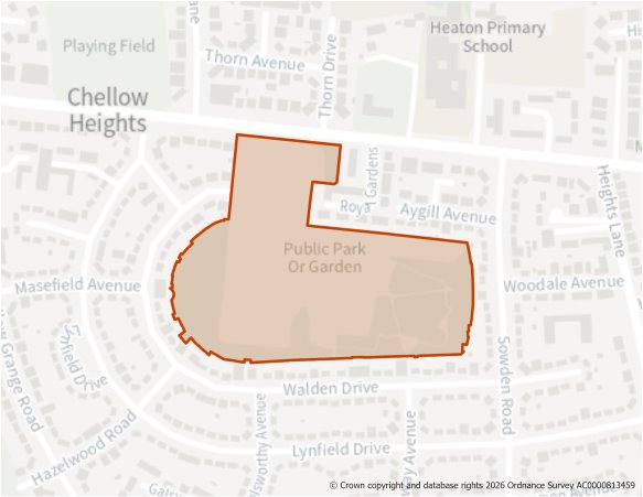
Site Size (ha) Gross: 5.60
Proposed Land Use: Housing
Minimum Development Capacity (Dwellings): 147
Site Type: Greenfield
Ward: Heaton & Frizinghall
Settlement: Bradford North West
Ownership: Public
Delivery Timescale: Long 2035+ (11+)
Site Specific Requirements
Design Principles
- Development should provide at least 147 dwellings as part of a high-quality built environment across part of the site with a large area (s) left open, in line with Policies ST4 and DS1, at a net density of 35 dph in line with Policy HO2. This should include affordable housing (in line with Policy HO4) and an appropriate mix of dwellings (in line with Policy HO3 and having due regard to relevant housing needs, evidence and the character of the area).
- The developer will need to determine which section of the site is most appropriate for development and provide a development design which considers opportunities for play, food production and areas for wildlife.
- New trees will be required throughout the site to offset any loss.
Site Access, Highways and Transport
- A new access would be required from Haworth Road* which should be agreed with Council Highways officers (*a notional access is currently shown on the plan).
Flooding, Water and Drainage
- The proposed development would see a change in the risk classification from less vulnerable to more vulnerable, according to the NPPF. Given the change in use and therefore vulnerability of the site, the FRA must show that the development can be designed to be safe and that there is adequate emergency planning provision (para 014 FRCC-PPG).
- A significant flow path emerges through the centre of the site within the medium risk surface water event plus climate change. Topographic flow routes should be considered and included in site design and ideally left in place to flood naturally when required. Any regrading of land must include for like for like volumes to ensure risk is contained safely onsite for the lifetime of development.
Natural and Historic Environment
- The site lies within Zone C (Recreational Pressure) - Residential development resulting in a net increase in dwellings will be required to mitigate any recreational pressure on the SPA/SAC caused by such development in accordance with the South Pennine Moors SPD and Policy NE3.
- A designated TPO Woodland area covers the part of the site which forms it's access from Haworth Rd. Development should be informed by an arboricultural assessment.
Environmental protection
- The whole of the site lies within either the 150m or 250m buffer of a former landfill area to the north west.. A Land Contamination Assessment – Phase 1 Report will be required as part of any planning application.
- All of the site is within a Minerals Safeguarding Area (Coal) and a small part for Sandstone. A mineral resource assessment will be required as part of any planning application to determine the extent and availability of any sandstone resource.
Open Space and Green / Blue Infrastructure
- Open space should be provided in line with Policy NE2, having regards to the standards set out Appendix 11.
- Site is partially within an area of medium provision and medium need for green and blue infrastructure. Development proposals should focus on carefully designed green and blue infrastructure to contribute towards site specific issues e.g. flood mitigation, urban cooling, etc.
Infrastructure Requirements
- Proportionate contributions to community infrastructure will be required, where appropriate, in line with Policies ID1 and ID2, and having regard to the Local Infrastructure Plan.
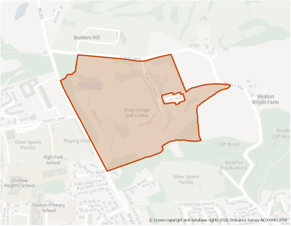
Site Size (ha) Gross: 20.34
Proposed Land Use: Housing
Minimum Development Capacity (Dwellings): 392
Site Type: Greenfield
Ward: Heaton & Frizinghall
Settlement: Bradford North West
Ownership: Private
Delivery Timescale: Medium 2030-2035 (6-10)
Site Specific Requirements
Design Principles
- Development should provide at least 392 dwellings as part of a high-quality built environment in line with Policies ST4 and DS1, at a net density of 35 dph in line with Policy HO2. This should include affordable housing (in line with Policy HO4 and an appropriate mix of dwellings (in line with Policy HO3 and having due regard relevant housing needs evidence and the character of the area).
- A sensitive design and layout will be required taking into consideration the site’s location on the edge of the settlement. This should include appropriate landscaping in the form of buffer zones particularly across the site to complement and enhance the woodland edges and provide new wildlife corridors for birds, mammals and invertebrates linked to adjacent areas.
- Mature trees on the frontage of Bingley Road should be maintained and development set back from Long Lane with new trees provided to maintain a respectful distance from the new crematoria to the north
Site Access, Highways and Transport
- A new access would be required from Bingley Road.
Flooding, Water and Drainage
- The proposed development would see a change in the risk classification from less vulnerable to more vulnerable, according to the NPPF. Given the change in use and therefore vulnerability of the site, the FRA must show that the development can be designed to be safe and that there is adequate emergency planning provision (para 014 FRCC-PPG).
Natural and Historic Environment
- The site lies within Zone C (Recreational Pressure) - Residential development resulting in a net increase in dwellings will be required to mitigate any recreational pressure on the SPA/SAC caused by such development in accordance with the South Pennine Moors SPD and Policy NE3.
- The site adjoins the Heaton Woods, Northcliffe Woods and Old Springs Woods LWS along part of its southern boundary, which is also identified as Priority Habitat (deciduous woodland) and small part of this is within its boundary. The majority of its area is a bat alert area , except for the north east corner. A large part of the site is identified as part of the Wildlife Habitat Network as it contains; broad-leaved planted woodland on its the north western, western, south western edges; large areas identified as amenity grassland and scatterd scrubs/trees on central sections; as well as adjoins an area identified as lowland mixed decidous woodland on its southern boundary. Development should provide a enhanced wildlife corridor strtching from the valley in the north west corner down to the eastern end of the site, as well as This should be a mixture of species rich grassland and woodland augment the existing woodland with locally native woodland and ground flora planting. An ecological survey will be required as part of any planning application to establish the extent/impacts as well as to identify appropriate mitigation. Early engagement with the Council's Biodiversity Officer is recommended.
- The site adjoins an area of ancient woodland at Royds Cliff Wood at its south eastern boundary and the 25m buffer zone falls into a small part of the site. There are two TPO Woodlands within the site area (i.e. northwestern corner and to centre). A further TPO woodland adjoins the site at its southwestern boundary, and its 25m buffer zone encroaches into the site. The are also several individual TPO's along the site's boundary at its SW corner. Development should be informed by an arboricultural assessment.
- The site is identified in the LNRS with the preferred measure are B4_M02: Significantly boost biodiversity wherever possible where there are existing habitats alongside transport infrastructure, and T1_M01: Through natural processes and planting, create biodiverse, site-suitable, and adaptable woodland habitats to buffer and connect existing ancient woodlands and ancient/veteran trees.
- The sites western edge lies within the 50M buffer zone for the grade II listed Hallmark Cards Factory (ref 1/4/10032). To minimise/mitigate harm potential harm of development on the setting of the this heritage assets, proposals should; (1) consider the inclusion of appropiate landscaping to filter views/provide bufffer in areas closest to heritage assets, and (2) give careful attention relation to boundary treatments along these receptors – hedges and stone walls being more in keeping with the rural character in particular of the areas around Heaton Shay and Heaton Royd. Development of the site, and in particular the areas close to the heritage assets should respond to and take design cues from the sense of place and rural context of the area.
- The site is located within a bat alert area. An ecological survey will be required as part of any planning application to establish the extent/impacts as well as to identify appropriate mitigation.
- The majority of the site is grade 4 agricultural land. The western & south western edge is classed as urban land.
Environmental protection
- A small landfill areas lies in the centre of the site (ref 13nw17). Remainder of the site lies within the 150m or 250m buffer of a former landfill area that adjoins its northern boundary. A Land Contamination Assessment – Phase 1 Report will be required as part of any planning application.
- The northern and eastern parts of the site are located in a Development High Risk Area for coal mining, indicating that it contains one or more recorded former related features at surface or shallow depth. A Coal Mining Risk Assessment (CMRA) will be required as part of any planning application.
- All of the site is within a Minerals Safeguarding Area (Coal) and the south western part for Sandstone. A mineral resource assessment will be required as part of any planning application to determine the extent and availability of any sandstone resource.
Open Space and Green / Blue Infrastructure
- Open space should be provided in line with Policy NE2, having regards to the standards set out Appendix 11.
- Site is partially within an area of low provision and high need for green and blue infrastructure. Development proposals should focus on carefully designed green and blue infrastructure to contribute towards site specific issues e.g. flood mitigation, urban cooling, etc.
Landscape
- The site is located within the Cottingley Urban Edge Wooded Valleys and Slopes Landscape Character area/type (H1).
- Development should seek to retain pockets of tree planting to integrate built form and retain the partially wooded character and valued elements of the site. Development should be avoided in the east where the landscape is more sensitive due to historic field pattern and time depth related to nearby Listed Buildings.
Green Belt (and Golden Rules)
- Site has been removed from the Green Belt. Development on the site should be consistent with the “Golden Rules” set out in the NPPF in relation to affordable housing, necessary improvements to infrastructure and accessible green space provision.
Infrastructure Requirements
- Proportionate contributions to community infrastructure will be required, where appropriate, in line with Policies ID1 and ID2, and having regard to the Local Infrastructure Plan.
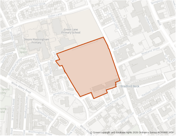
Site Size (ha) Gross: 3.03
Proposed Land Use: Housing
Minimum Development Capacity (Dwellings): 341
Site Type: PDL
Ward: Manningham
Settlement: Bradford North West
Ownership: Private
Delivery Timescale: Medium 2030-2035 (6-10)
Site Specific Requirements
Design Principles
- Development should provide at least 341 dwellings as part of a high-quality built environment in line with Policies ST4 and DS1, at a net density of 150 dph in line with Policy HO2. This should include affordable housing (in line with Policy HO4) and an appropriate mix of dwellings (in line with Policy HO3 and having due regard to relevant housing needs, evidence and the character of the area).
- It is in a sustainable location close to local amenities and public transport routes and is appropriate for a higher level of development (apartments). These could be for older people.
- The design of the development should be to a high standard and ensure any impact on adjacent listed buildings and local character are mitigated and enhanced.
Site Access, Highways and Transport
- Site access from Lumb Lane.
Natural and Historic Environment
- The site lies adjacent to Eldon Place Conservation Area. It also lies within the 50M buffer of listed buildings to the south east at Hannover Square ref 34/155 and to the north (ref 34/475 & 34/477).
- There are no heritage assets on the site; but the listed strictures of the former Drummonds Mill Grade II Listed Building that was cleared due to a fire will need to be retained wherever possible. There is a need for archaeological recording by condition in advance of development. Potential development should improve the condition and setting of the listed building and ensuring their long term preservation.
- The site is identified in the LNRS with the preferred measure are B3_M03: Enhance the boundaries of brownfield sites; W2_MO3: Make more space in water for the plants and animals that live there; and B3_M02: Enhance (rather than replace) existing habitats on some areas of brownfield.
Environmental protection
- Site is located within the Clean Air Zone and adjoins Lumb Lane where NO2 (levels = 30 parts per million (plus)). Development must be in accordance with the requirements set out in Policy CR1.
- There is some potential risk of contamination, as 1/3 of the site had a former Mill use. A Land Contamination Assessment – Phase 1 Report will be required as part of any planning application due determining any potential impacts. Impacts should be addressed in line with Policy CR2.
- All of the site is within a Minerals Safeguarding Area (Coal). A mineral resource assessment will be required as part of any planning application to determine the extent and availability of any sandstone resource.
Flooding, Water and Drainage
- It should be appropriate to develop this site for more vulnerable purposes given its location in Flood Zone 1.
- The location and path of the diversion tunnel should be confirmed through a survey as part of the site-specific FRA. There should be no development above the Bradford Beck Diversion Tunnel which is assumed to be located beneath the site.
- Assuming the culvert is located beneath the site, opportunities for opening up the culvert should be explored for inclusion in site design as a blue green corridor. This would remove any residual risk of flooding to the site as a result of culvert failure or blockage.
- The third-generation surface water modelling for the site is based on outdated LiDAR data from when a previous development was present on site. This previous development has since been demolished and as such, existing flood risk from surface water to the site is unknown. Therefore, new detailed modelling based on an updated topographic survey will be required to inform on onsite surface water depths and hazards. Post development modelling must demonstrate that development at the site will not result in offsite detriment.
- A detailed drainage strategy will be required to ensure there is no increase in surface water flood risk elsewhere as a result of new development. Site runoff should be maintained at current rates (likely to be brownfield) and, where possible, betterment should be achieved. The use of infiltration SuDS should be investigated.
Open Space and Green / Blue Infrastructure
- Open space should be provided in line with Policy NE2, having regards to the standards set out Appendix 11.
- The site lies within the Bradford City Centre Opportunity Area, as identified in the Green and Blue Infrastructure Strategy (GBIS). The strategy should be consulted to identify opportunities for incorporating measures within the development that enhance the quality of, and connectivity to, the green and blue infrastructure network in this area.
- Site is partially within an area of low provision and high need for green and blue infrastructure. Development proposals should focus on carefully designed green and blue infrastructure to contribute towards site specific issues e.g. flood mitigation, urban cooling, etc.
Infrastructure Requirements
- Proportionate contributions to community infrastructure will be required, where appropriate, in line with Policies ID1 and ID2, and having regard to the Local Infrastructure Plan.
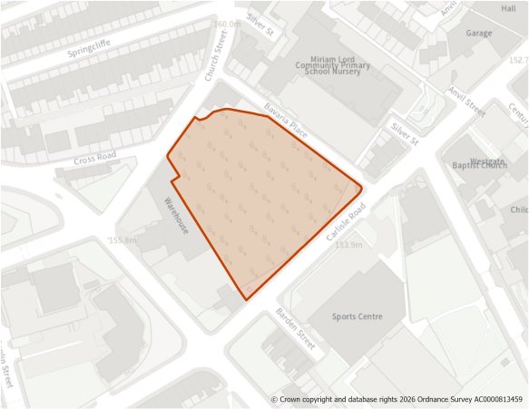
Site Size (ha) Gross: 1.07
Proposed Land Use: Housing
Minimum Development Capacity (Dwellings): 72
Site Type: PDL
Ward: Manningham
Settlement: Bradford North West
Ownership: Mixed
Delivery Timescale: Long 2035+ (11+)
Site Specific Requirements
Design Principles
- Development should provide at least 72 dwellings as part of a high-quality built environment in line with Policies ST4 and DS1, at a net density of 75 dph in line with Policy HO2. This should include affordable housing (in line with Policy HO4) and an appropriate mix of dwellings (in line with Policy HO3 and having due regard to relevant housing needs, evidence and the character of the area).
Site Access, Highways and Transport
- A new access would be required from Carlisle Road.
Flooding, Water and Drainage
- The proposed development would see a change in the risk classification from less vulnerable to more vulnerable, according to the NPPF. Given the change in use and therefore vulnerability of the site, the FRA must show that the development can be designed to be safe and that there is adequate emergency planning provision (para 014 FRCC-PPG).
- Surface water risk is constrained by the area of existing development within the site. Any change in site layout where current buildings are to be demolished will require detailed surface water modelling.
Natural and Historic Environment
- A small Woodland TPO lies to the north west and its 15m buffer zone clips into the site. Development should be informed by an arboricultural assessment.
- A Grade II listed building located at top corner of site (ref 30/1173. Development of site may stimulate re-use of listed building at risk. The north western part of the site lies within the 50m buffer of Grade II listed building (ref 30/1264). While the eastern corner lies within the buffer for Manningham Baths grade II listed building (ref 503050). Adequate mitigation would be achieved via appropriate design, layout and use of materials which would be expected to complement the surrounding area. Proposals should respect and enhance the setting of the listed former Police Station.
- The site is identified in the LNRS with the preferred measure are; B3_M01: Encourage temporary nature-rich uses on undeveloped brownfield sites.
Environmental protection
- Site is located within the Clean Air Zone and adjoins Lumb Lane. The southern & south western section of the site lies within area where NO2 = 30 parts per million (plus). Development must be in accordance with the requirements set out in Policy CR1.
- There is some potential risk of contamination, as 1/3 of the site had a former commercial use. A Land Contamination Assessment – Phase 1 Report will be required as part of any planning application due determining any potential impacts. Impacts should be addressed in line with Policy CR2.
- All of the site is within a Minerals Safeguarding Area (Coal). A mineral resource assessment will be required as part of any planning application to determine the extent and availability of any sandstone resource.
Open Space and Green / Blue Infrastructure
- Open space should be provided in line with Policy NE2, having regards to the standards set out Appendix 11.
- Site is partially within an area of low provision and high need for green and blue infrastructure. Development proposals should focus on carefully designed green and blue infrastructure to contribute towards site specific issues e.g. flood mitigation, urban cooling, etc.
Infrastructure Requirements
- Proportionate contributions to community infrastructure will be required, where appropriate, in line with Policies ID1 and ID2, and having regard to the Local Infrastructure Plan.
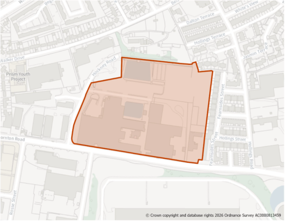
Site Size (ha) Gross: 5.08
Proposed Land Use: Housing
Minimum Development Capacity (Dwellings): 133
Site Type: Mixed
Ward: Manningham
Settlement: Bradford North West
Ownership: Private
Delivery Timescale: 2035-2040
Site Specific Requirements
Design Principles
- Development should provide at least 133 dwellings as part of a high-quality built environment in line with Policies ST4 and DS1, at a net density of 35 dph in line with Policy HO2. This should include affordable housing (in line with Policy HO4) and an appropriate mix of dwellings (in line with Policy HO3 and having due regard to relevant housing needs evidence and the character of the area).
Site Access, Highways and Transport
- A new access will be required from Thornton Road. This should be designed to respond to the sites contours and to the satisfaction of the Councils Highways Officers
Natural and Historic Environment
- All of the site is within a bat alert area. Ecology survey may be required at the planning application stage. Early engagement with the Council's Biodiversity Officer is recommended.
- The mill and most of the site is grade II listed. Proposals should seek to retain heritage assets and a sympathetic conversion of it, as well as support sustainability of the assets and enhance their settings through appropriate design and landscaping.
- The site is identified in the LNRS with the preferred measure B3_M03: Enhance the boundaries of brownfield sites, especially larger ones, for example by adding hedgerows, so that they look more attractive as well as help wildlife.
Environmental Protection
- Site is located within a Clean Air Zone. A small part of its southern edge lies within area where NO2 = 30 parts per million (plus). Development must be in accordance with the requirements set out in Policy CR1.
Open Space and Green / Blue Infrastructure
- Open space should be provided in line with Policy NE2, having regards to the standards set out Appendix 10.
- The site lies within the Bradford City Centre Opportunity Area, as identified in the Green and Blue Infrastructure Strategy (GBIS). The strategy should be consulted to identify opportunities for incorporating measures within the development that enhance the quality of, and connectivity to, the green and blue infrastructure network in this area.
- Site is partially within an area of low provision and high need for green and blue infrastructure. Development proposals should focus on carefully designed green and blue infrastructure to contribute towards site specific issues e.g. flood mitigation, urban cooling, etc.
Infrastructure Requirements
- Proportionate contributions to community infrastructure will be required, where appropriate, in line with Policies ID1 and ID2, and having regard to the Local Infrastructure Plan.
H784: Rayner Mount, Allerton Comment
Site Boundary
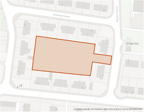
Site Size (ha) Gross: 0.24
Proposed Land Use: Housing
Minimum Development Capacity (Dwellings): 8
Site Type: Greenfield
Ward: Thornton & Allerton
Settlement: Bradford North West
Ownership: Private
Delivery Timescale: Medium 2030-2035 (6-10)
Site Specific Requirements
Design Principles
- Development should provide at least 8 dwellings as part of a high-quality built environment in line with Policies ST4 and DS1, at a net density of 35 dph in line with Policy HO2. This should include affordable housing (in line with Policy HO4) and an appropriate mix of dwellings (in line with Policy HO3 and having due regard to relevant housing needs, evidence and the character of the area).
Site Access, Highways and Transport
- A new access would be required from Rayner Mount.
Natural and Historic Environment
- The site lies within Zone C (Recreational Pressure) – Residential development resulting in a net increase in dwellings will be required to mitigate any recreational pressure on the SPA/SAC caused by such development in accordance with the South Pennine Moors SPD and Policy NE3.
- The site is identified in the LNRS with the preferred measure is; T2_M04: Extend and connect tree and woodland cover across the White Rose Forest area in West Yorkshire to contribute to base target of 16.5 per cent and stretched target of 18.5 per cent by 2050 using 'right tree, right place' principles.
Environmental protection
- All of the site is within a Minerals Safeguarding Area (Coal). A mineral resource assessment will be required as part of any planning application to determine the extent and availability of any sandstone resource.
Open Space and Green / Blue Infrastructure
- Open space should be provided in line with Policy NE2, having regards to the standards set out Appendix 11.
- Site is within an area of low provision and high need for green and blue infrastructure. Development proposals should focus on carefully designed green and blue infrastructure to contribute towards site specific issues e.g. flood mitigation, urban cooling, etc.
Infrastructure Requirements
- Proportionate contributions to community infrastructure will be required, where appropriate, in line with Policies ID1 and ID2, and having regard to the Local Infrastructure Plan.
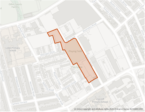
Site Size (ha) Gross: 1.34
Proposed Land Use: Housing
Minimum Development Capacity (Dwellings): 90
Site Type: PDL
Ward: Toller
Settlement: Bradford North West
Ownership: Private
Delivery Timescale: Long 2035+ (11+)
Site Specific Requirements
Design Principles
- Development should provide at least 90 dwellings as part of a high-quality built environment in line with Policies ST4 and DS1, at a net density of 75 dph in line with Policy HO2. This should include affordable housing (in line with Policy HO4) and an appropriate mix of dwellings (in line with Policy HO3 and having due regard to relevant housing needs, evidence and the character of the area).
Site Access, Highways and Transport
- A new site access is required.
Natural and Historic Environment
- Site is adjacent to the North Park Rd Conservation Area. It is within the 50m buffer zone for Manningham Mills Grade II* (ref 8/135) and Lilycroft Primary School (27/1172). Development must protect, enhance these heritage assets and their settings via an appropiate layout, density, scale, form and appearance that must complement them. Its scale will need to respect Manningham Mills, and views towards and within the site. Any open spaces provisions should emphasise a sense of place and heritage enhancement.
- The site is identified in the LNRS with the preferred measure is B3_M01: Encourage temporary (so-called ‘meanwhile-use’, in planning terms) nature-rich uses on undeveloped.
Environmental protection
- The site lies within the 150m or 250m buffer of a former landfill area that adjoins its northern boundary. There maybe some potential of contamination risk related to sites historic commercial use. A Land Contamination Assessment – Phase 1 Report will be required as part of any planning application.
- All of the site is within a Minerals Safeguarding Area (Coal and Sandstone). A mineral resource assessment will be required as part of any planning application to determine the extent and availability of any sandstone resource
Open Space and Green / Blue Infrastructure
- Open space should be provided in line with Policy NE2, having regards to the standards set out Appendix 11.
- Site is within an area of low provision and high need for green and blue infrastructure. Development proposals should focus on carefully designed green and blue infrastructure to contribute towards site specific issues e.g. flood mitigation, urban cooling, etc.
Infrastructure Requirements
- Proportionate contributions to community infrastructure will be required, where appropriate, in line with Policies ID1 and ID2, and having regard to the Local Infrastructure Plan.
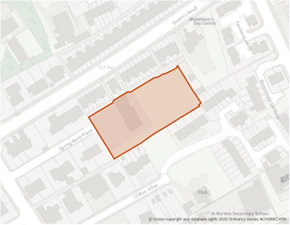
Site Size (ha) Gross: 0.57
Proposed Land Use: Housing
Minimum Development Capacity (Dwellings): 9
Site Type: Greenfield
Ward: Manningham
Settlement: Bradford North West
Ownership: Private
Delivery Timescale: Short 2025- 2030 (1-5)
Site Specific Requirements
Design Principles
- Development should provide at least 9 dwellings as part of a high-quality built environment in line with Policies ST4 and DS1, at a net density of 50 dph in line with Policy HO2. This should include affordable housing (in line with Policy HO4) and an appropriate mix of dwellings (in line with Policy HO3 and having due regard to relevant housing needs, evidence and the character of the area).
Site Access, Highways and Transport
- A new access would be required from Spring Bank Place.
Natural and Historic Environment
- The site lies within in Apsley Crescent Conservation Area. Its western and southern parts lie within the buffer zone of several listed buildings to the west and south (refs 32/400 & 32/401 & 32/404) of it.
Environmental protection
- The site falls within the Clean Air Zone and its northern boundary is adjacent to an AQMA (Manningham Lane / Queens Rd), as well as adjoins Queens Rd where NO2 levels = 30 parts per million (plus). Development must be in accordance with the requirements set out in Policy CR1.
- The site lies within the 150m buffer of a former landfill area that lies to the east of it , and partly within the the 250m buffer of former landfill sites to the south east. A Land Contamination Assessment – Phase 1 Report will be required as part of any planning application.
- Within 200m of 2 operational / permitted waste management sites. Midland Road Household Waste Recycling Centre lies to the north east of the site and Manningham Car Breakers (Vehicle Depollution Facility) lies to the south. The design of proposals should ensure that no unreasonable restrictions are placed upon the operation of the facility and that it would prejudice its current or future operations, as well as the amenity of future occupiers.
- All of the site is within a Minerals Safeguarding Area (Coal and sandstone). A mineral resource assessment will be required as part of any planning application to determine the extent and availability of any sandstone resource.
Open Space and Green / Blue Infrastructure
- Open space should be provided in line with Policy NE2, having regards to the standards set out Appendix 11.
- The site lies within the Bradford City Centre Opportunity Area, as identified in the Green and Blue Infrastructure Strategy (GBIS). The strategy should be consulted to identify opportunities for incorporating measures within the development that enhance the quality of, and connectivity to, the green and blue infrastructure network in this area.
- Site is within an area of low provision and high need for green and blue infrastructure. Development proposals should focus on carefully designed green and blue infrastructure to contribute towards site specific issues e.g. flood mitigation, urban cooling, etc.
Infrastructure Requirements
- Proportionate contributions to community infrastructure will be required, where appropriate, in line with Policies ID1 and ID2, and having regard to the Local Infrastructure Plan.
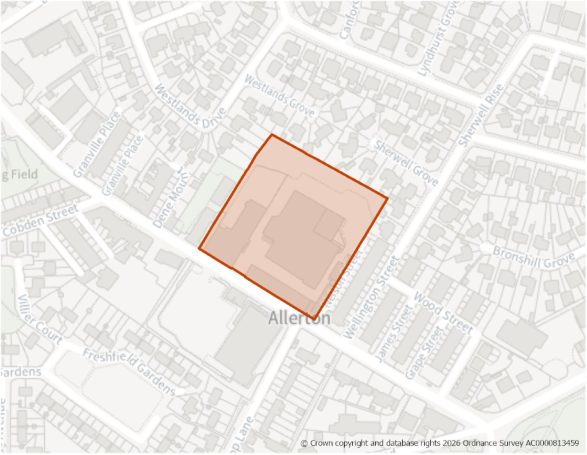
Site Size (ha) Gross: 1.18
Proposed Land Use: Housing
Minimum Development Capacity (Dwellings): 200
Site Type: PDL
Ward: Thornton & Allerton
Settlement: Bradford North West
Ownership: Private
Delivery Timescale: Long 2035+ (11+)
Site Specific Requirements
Design Principles
- Development should provide at least 200 dwellings as part of a high-quality built environment in line with Policies ST4 and DS1, at a net density of 50 dph in line with Policy HO2. This should include affordable housing (in line with Policy HO4 and an appropriate mix of dwellings (in line with Policy HO3 and having due regard relevant housing needs evidence and the character of the area).
Site Access, Highways and Transport
- A new access would be required from Allerton Road.
Flooding, Water and Drainage
- It should be appropriate to develop this site for more vulnerable purposes given its location in Flood Zone 1. However, there is risk from surface water in the medium and low risk events, currently affecting the eastern and northern sides of the site which worsens with climate change. A detailed drainage strategy will be required to ensure there is no increase in surface water flood risk elsewhere as a result of new development. A wider strategy may be required given the clear flow route offsite which travels through the site.
- Historic mapping indicates there may be a watercourse culverted beneath the site. If present, the culvert represents potential residual risk of flooding to the site through culvert failure or blockage. This may need to be further investigated and modelled at the FRA stage. Modelling should include for residual risk and options for culvert removal. No development should take place over the top of a culvert nor within 8m either side of the culverted section of watercourse. Assuming the culvert is located beneath the site, opportunities for opening up the culvert should be explored for inclusion in site design as a blue green corridor. This would remove any residual risk of flooding to the site as a result of culvert failure or blockage.
- Surface water should be retained onsite which may reduce units. This will require detailed surface water modelling based on layout plans and detailed design and full consultation with the LLFA on required runoff rates, likely to be brownfield or betterment. The use of infiltration SuDS should be investigated for suitability across the majority of the site.
- Groundwater conditions must be investigated further through the site-specific FRA to ascertain groundwater levels and conditions.
- Given the historic sewer flooding in the area, developers should contact Yorkshire Water directly to check specific details at the FRA stage.
Natural and Historic Environment
- The site lies within Zone C (Recreational Pressure) – Residential development resulting in a net increase in dwellings will be required to mitigate any recreational pressure on the SPA/SAC caused by such development in accordance with the South Pennine Moors SPD and Policy NE3.
- The site contains Grade II Listed Buildings, part of the Allerton Mills complex, and is adjacent to the Garde II listed Church of St Peter. Proposals are required to give careful attention to the intended use, design, layout and appearance of any development with appropriate landscaping, to maintain and potentially enhance significance.
Environmental protection
- There may be some potential risk of contaminsation related to the sites former industrial /textile use. Development must be in accordance with the requirements set out in Policy CR1
- The site is identified in the LNRS with the preferred measure are; B3_M01: Encourage temporary nature-rich uses on undeveloped brownfield sites
- All of the site is within a Minerals Safeguarding Area (Coal). A mineral resource assessment will be required as part of any planning application to determine the extent and availability of any resource
Open Space and Green / Blue Infrastructure
- Open space should be provided in line with Policy NE2, having regards to the standards set out Appendix 11.
- Site is partially within an area of low provision and high need for green and blue infrastructure. Development proposals should focus on carefully designed green and blue infrastructure to contribute towards site specific issues e.g. flood mitigation, urban cooling etc.
Infrastructure Requirements
- Proportionate contributions to community infrastructure will be required, where appropriate, in line with Policies ID1 and ID2, and having regard to the Local Infrastructure Plan.
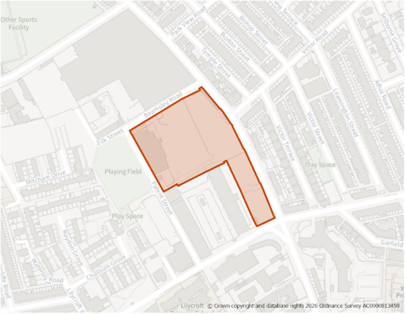
Site Size (ha) Gross: 1.91
Proposed Land Use: Housing
Minimum Development Capacity (Dwellings): 129
Site Type: PDL
Ward: Toller
Settlement: Bradford North West
Ownership: Private
Delivery Timescale: Long 2035+ (11+)
Site Specific Requirements
Design Principles
- Development should provide at least 129 dwellings as part of a high-quality built environment in line with Policies ST4 and DS1, at a net density of 75 dph in line with Policy HO2. This should include affordable housing (in line with Policy HO4) and an appropriate mix of dwellings (in line with Policy HO3 and having due regard to relevant housing needs, evidence and the character of the area).
Site Access, Highways and Transport
- A new access would be required from Heaton Road.
Flooding, Water and Drainage
- The proposed development would see a change in the risk classification from less vulnerable to more vulnerable, according to the NPPF.
- Given the change in use and therefore vulnerability of the site, the FRA must show that the development can be designed to be safe and that there is adequate emergency planning provision (para 014 FRCC-PPG).
Natural and Historic Environment
- The site is entirely within the North Park Road Conservation Area and consists of part of the Grade II* listed Manningham Mills complex, including the imposing 250 ft high chimney. Manningham Mills (ancillary buildings and boiler house) are included on the Heritage at Risk Register. The Conservation Area Appraisal identifies the area as providing a positive contribution to the character of the CA. A small part at the SW corner of the site lies within the 50m buffer for grade II listed Lilycroft Primary School ref 27/1172. Proposals would need to incoporate mitigations such as appropriate distancing from existing structures, sympathetic design and layout to achieve a complementary development.
- The site is identified in the LNRS with the preferred measure are B3_M01: Encourage temporary nature-rich uses on undeveloped brownfield sites.
Environmental protection
- The site lies within the 250m buffer of a former landfill area that adjoins its northern boundary. A Land Contamination Assessment – Phase 1 Report will be required as part of any planning application.
- There may be some potential risk of contamination related to the sites former industrial /textile use. Development must be in accordance with the requirements set out in Policy CR1.
- All of the site is within a Minerals Safeguarding Area (Coal and sandstone). A mineral resource assessment will be required as part of any planning application to determine the extent and availability of any sandstone resources.
Open Space and Green / Blue Infrastructure
- Open space should be provided in line with Policy NE2, having regards to the standards set out Appendix 11.
- Site is within an area of low provision and high need for green and blue infrastructure. Development proposals should focus on carefully designed green and blue infrastructure to contribute towards site specific issues e.g. flood mitigation, urban cooling, etc.
Infrastructure Requirements
- Proportionate contributions to community infrastructure will be required, where appropriate, in line with Policies ID1 and ID2, and having regard to the Local Infrastructure Plan.
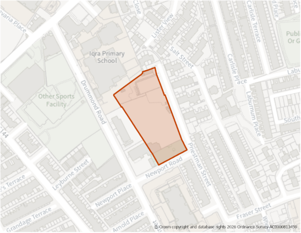
Site Size (ha) Gross: 0.82
Proposed Land Use: Housing
Minimum Development Capacity (Dwellings): 55
Site Type: PDL
Ward: Manningham
Settlement: Bradford North West
Ownership: Private
Delivery Timescale: Long 2035+ (11+)
Site Specific Requirements
Design Principles
- Development should provide at least 55 dwellings as part of a high-quality built environment in line with Policies ST4 and DS1, at a net density of 75 dph in line with Policy HO2. This should include affordable housing (in line with Policy HO4) and an appropriate mix of dwellings (in line with Policy HO3 and having due regard to relevant housing needs, evidence and the character of the area).
Site Access, Highways and Transport
- A new access would be required from Newport Road.
Flooding, Water and Drainage
- The proposed development would see a change in the risk classification from less vulnerable to more vulnerable, according to the NPPF.Given the change in use and therefore vulnerability of the site, the FRA must show that the development can be designed to be safe and that there is adequate emergency planning provision (para 014 FRCC-PPG).
- Surface water risk is constrained by the area of existing development within the site. Any change in site layout where current buildings are to be demolished will require detailed surface water modelling.
Environmental protection
- The site falls within the Clean Air Zone. Development must be in accordance with the requirements set out in Policy CR1.
- There may be some potential risk of contaminsation related to the sites former industrial /textile use. Development must be in accordance with the requirements set out in Policy CR1.
- All of the site is within a Minerals Safeguarding Area (Coal) and a small part for Sandstone. A mineral resource assessment will be required as part of any planning application to determine the extent and availability of any sandstone resource.
Open Space and Green / Blue Infrastructure
- Open space should be provided in line with Policy NE2, having regards to the standards set out Appendix 11.
- The site lies within the Bradford City Centre Opportunity Area, as identified in the Green and Blue Infrastructure Strategy (GBIS). The strategy should be consulted to identify opportunities for incorporating measures within the development that enhance the quality of, and connectivity to, the green and blue infrastructure network in this area.
- Site is partially within an area of low provision and high need for green and blue infrastructure. Development proposals should focus on carefully designed green and blue infrastructure to contribute towards site specific issues e.g. flood mitigation, urban cooling, etc.
Infrastructure Requirements
- Proportionate contributions to community infrastructure will be required, where appropriate, in line with Policies ID1 and ID2, and having regard to the Local Infrastructure Plan.
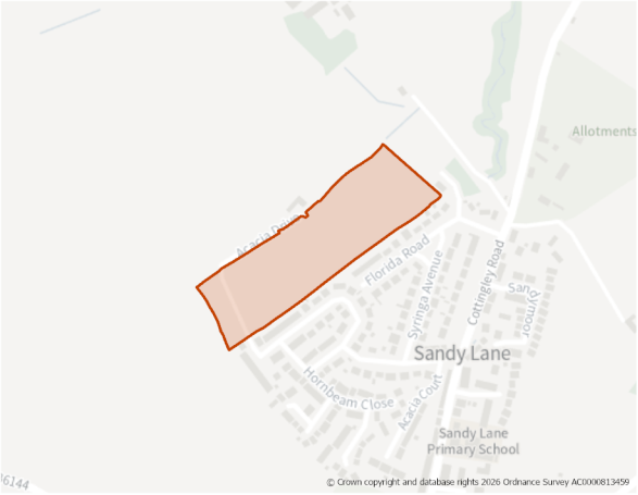
Site Size (ha) Gross: 3.73
Proposed Land Use: Housing
Minimum Development Capacity (Dwellings): 120
Site Type: Greenfield
Ward: Thornton & Allerton
Settlement: Bradford North West
Ownership: Private
Delivery Timescale: Short 2025- 2030 (1-5)
Site Specific Requirements
Design Principles
- Development should provide at least 120 dwellings[1] as part of a high-quality built environment in line with Policies ST4 and DS1. This should include affordable housing (in line with Policy HO4) and an appropriate mix of dwellings (in line with Policy HO3 and having due regard to relevant housing needs, evidence and the character of the area).
- A sensitive design and layout will be required taking into consideration the site’s location on the edge of the settlement. This should include appropriate landscaping and seeking to avoid areas that are at risk of fluvial and surface water flooding.
Site Access, Highways and Transport
- A new access would be required from Acacia Drive.
Flooding, Water and Drainage
- The proposed development would see a change in the risk classification from less vulnerable to more vulnerable, according to the NPPF. Given the change in use and therefore vulnerability of the site, the FRA must show that the development can be designed to be safe and that there is adequate emergency planning provision (para 014 FRCC-PPG).
Natural and Historic Environment
- The site lies within Zone C (Recreational Pressure) – Residential development resulting in a net increase in dwellings will be required to mitigate any recreational pressure on the SPA/SAC caused by such development in accordance with the South Pennine Moors SPD and Policy NE3.
- The site is an open field site which may be semi-improved. The south western part of site lies within a bat alert area. There are records of priority species of open farmland including brown hare and ground nesting birds (lapwing, skylark etc) . These are declining species and the habitat should be conserved. An Ecology Survey will likely be required at planning stage. Early engagement with the Council’s Biodiversity Officer is recommended.
- Development of this site may need to consider whether it will impact the setting of the World Heritage Site, in terms of important views to and from the WHS and rural backdrops. Appropriate planting/landscaping may need to be considered, depending on further investigation.
- The site is identified in the LNRS with the preferred measure T2_M05: Help more red squirrels to move back into West Yorkshire: buffer, connect, improve and safeguard existing woodland and create new woodland in areas where red squirrels are expanding (or could do so); to encourage existing populations to spread
- The site is located within a bat alert area. An ecological survey will be required as part of any planning application to establish the extent/impacts as well as to identify appropriate mitigation.
- The site falls within grade 4 agricultural land.
Environmental protection
- The northern 1/5 of the site is partially within a Development High Risk Area for coal mining, indicating that it contains one or more recorded former related features at surface or shallow depth. The remainder of the site is within a low risk area. A Coal Mining Risk Assessment (CMRA) will be required as part of any planning application.
- Pylon adjoins the site at its northern edge. The northern half of the site lies within the buffer zone for an overhead electricity transmission lines/cables (275 kv national grid). This may impact the layout of development.
- Manywells Aqueduct (from historic land use layer) runs along the western boundary of the site.
Open Space and Green / Blue Infrastructure
- Open space should be provided in line with Policy NE2, having regards to the standards set out Appendix 11.
- Site is partially within an area of low provision and medium need for green and blue infrastructure. Development proposals should focus on carefully designed green and blue infrastructure to contribute towards site specific issues e.g. flood mitigation, urban cooling, etc.
Landscape
- The site is located within the Thornton, Queensbury and Wilsden Mixed Upland Pasture Landscape Character area/type (E1).
- Historic drystone walls, hedgerows and boundary trees should be maintained and strengthened to help integrate new development into the landscape and mitigate impacts on recreational users of the PRoW network adjacent to, and west of the site. The historic farmstead of Mount Pleasant Farm should remain distinct from any new development.
Green Belt (and Golden Rules)
- Site has been removed from the Green Belt. Development on the site should be consistent with the “Golden Rules” set out in the NPPF in relation to affordable housing, necessary improvements to infrastructure and accessible green space provision.
Infrastructure Requirements
- Proportionate contributions to community infrastructure will be required, where appropriate, in line with Policies ID1 and ID2, and having regard to the Local Infrastructure Plan.
Planning Permission
- A planning application is pending on the site which could be determined before the Local Plan is adopted. Accordingly, it has been identified as a site allocation.
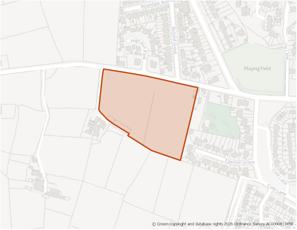
Site Size (ha) Gross: 2.58
Proposed Land Use: Housing
Minimum Development Capacity (Dwellings): 68
Site Type: Greenfield
Ward: Thornton & Allerton
Settlement: Bradford North West
Ownership: Private
Delivery Timescale: Medium 2030-2035 (6-10)
Site Specific Requirements
Design Principles
- Development should provide at least 68 dwellings as part of a high-quality built environment in line with Policies ST4 and DS1, with a net density of 35 dph in line with Policy HO2. This should include affordable housing (in line with Policy HO4) and an appropriate mix of dwellings (in line with Policy HO3 and having due regard to relevant housing needs, evidence and the character of the area).
- A sensitive design and layout will be required taking into consideration the site’s location on the edge of the settlement. This should include appropriate landscaping and seeking to avoid areas that are at risk of fluvial and surface water flooding.
Site Access, Highways and Transport
- A new access would be required from Allerton Road.
Natural and Historic Environment
- The site lies within Zone C (Recreational Pressure) – Residential development resulting in a net increase in dwellings will be required to mitigate any recreational pressure on the SPA/SAC caused by such development in accordance with the South Pennine Moors SPD and Policy NE3.
- Development of this site may need to consider whether it will impact the setting of the Whorld heritage site, in terms of important views to and from the WHS and rural backdrops. Appropriate planting/landscaping may need to be considered, depending on further investigation.
- The site is located within grade 4 agricultural land.
Environmental protection
- The site lies within the 150m and 250m buffer of a former landfill area that adjoins its northern boundary. It may also have a history of mineral extraction and processing from a former quarry. A Land Contamination Assessment – Phase 1 Report will be required as part of any planning application.
- All of the site is within a Minerals Safeguarding Area (Coal and Sandstone). A mineral resource assessment will be required as part of any planning application to determine the extent and availability of any sandstone resource.
Open Space and Green / Blue Infrastructure
- Open space should be provided in line with Policy NE2, having regards to the standards set out Appendix 11.
- Site is partially within an area of low provision and medium need for green and blue infrastructure. Development proposals should focus on carefully designed green and blue infrastructure to contribute towards site specific issues e.g. flood mitigation, urban cooling, etc.
Landscape
- The site is located within the Thornton, Queensbury and Wilsden Mixed Upland Pasture Landscape Character area/type (E1).
- Retain drystone walls where possible and utilise tree buffers to soften the settlement edge in longer distance views from the south and west.
Infrastructure Requirements
- Proportionate contributions to community infrastructure will be required, where appropriate, in line with Policies ID1 and ID2, and having regard to the Local Infrastructure Plan.
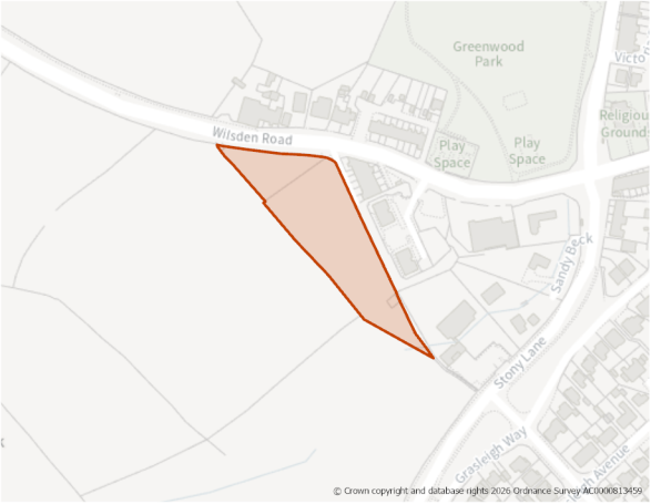
Site Size (ha) Gross: 0.70
Proposed Land Use: Housing
Minimum Development Capacity (Dwellings): 22
Site Type: Greenfield
Ward: Thornton & Allerton
Settlement: Bradford North West
Ownership: Private
Delivery Timescale: Long 2035+ (11+)
Site Specific Requirements
Design Principles
- Development should provide at least dwellings as part of a high-quality built environment in line with Policies ST4 and DS1, with a net density of 35 dph in line with Policy HO2. This should include affordable housing (in line with Policy HO4) and an appropriate mix of dwellings (in line with Policy HO3 and having due regard to relevant housing needs, evidence and the character of the area).
- A sensitive design and layout will be required taking into consideration the site’s location on the edge of the settlement. This should include appropriate landscaping and seeking to avoid areas that are at risk of fluvial and surface water flooding.
Site Access, Highways and Transport
- A new access would be required from Wilsden Road.
Natural and Historic Environment
- The site lies within Zone C (Recreational Pressure) – Residential development resulting in a net increase in dwellings will be required to mitigate any recreational pressure on the SPA/SAC caused by such development in accordance with the South Pennine Moors SPD and Policy NE3.
- All of site area lies within a bat alert area. An Ecology Survey will likely be required at planning stage. Early engagement with the Council’s Biodiversity Officer is recommended.
- The site adjoins an area designated as TPO Woodland at the south eastern site boundary. The 15M buffer zone extends into the site. Development should be informed by an arboricultural assessment.
- All of the site falls within grade 4 agricultural land.
- Northern part of the site lies within 50M buffer of Lower Swain Rd Farm Grade II Listed Building ref 4/1195.
Environmental protection
- The site lies within the 150m and 250m buffer of a former landfill area that adjoins its northern boundary. A Land Contamination Assessment – Phase 1 Report will be required as part of any planning application.
- All of the site is within a Minerals Safeguarding Area (Coal). A mineral resource assessment will be required as part of any planning application to determine the extent and availability of any sandstone resource.
Open Space and Green / Blue Infrastructure
- Open space should be provided in line with Policy NE2, having regards to the standards set out Appendix 11.
- Site is partially within an area of low provision and medium need for green and blue infrastructure. Development proposals should focus on carefully designed green and blue infrastructure to contribute towards site specific issues e.g. flood mitigation, urban cooling, etc.
Landscape
- The site is located within the Thornton, Queensbury and Wilsden Mixed Upland Pasture Landscape Character area/type (E1).
- There are opportunities here to sensitively integrate limited development (into landform and with appropriate vegetation) and soften the settlement edge. Development should carefully consider the waterway and its small scale landform. Drystone walls should be retained and enhanced.
Green Belt (and Golden Rules)
- Site has been removed from the Green Belt. Development on the site should be consistent with the “Golden Rules” set out in the NPPF in relation to affordable housing, necessary improvements to infrastructure and accessible green space provision.
Infrastructure Requirements
- Proportionate contributions to community infrastructure will be required, where appropriate, in line with Policies ID1 and ID2, and having regard to the Local Infrastructure Plan.
H1562: Allerton Lane/Chevet Mount, Allerton Comment
Site Boundary
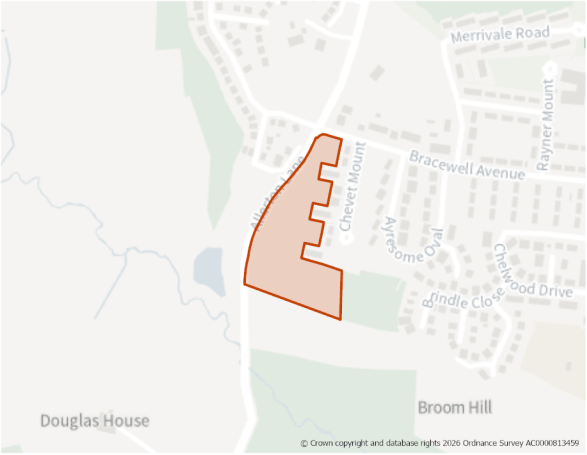
Site Size (ha) Gross: 1.67
Proposed Land Use: Housing
Minimum Development Capacity (Dwellings): 51
Site Type: Greenfield
Ward: Thornton & Allerton
Settlement: Bradford North West
Ownership: Private
Delivery Timescale: Short 2025- 2030 (1-5)
Site Specific Requirements
Design Principles
- Development should provide at least 51 dwellings[2] as part of a high-quality built environment in line with Policies ST4 and DS1. This should include affordable housing (in line with Policy HO4) and an appropriate mix of dwellings (in line with Policy HO3 and having due regard to relevant housing needs, evidence and the character of the area).
- A sensitive design and layout will be required, taking into consideration the site’s location on the edge of the settlement with appropriate landscaping on the western edge of the site together with maintenance of existing rights of way and open areas to the south and east.
Site Access, Highways and Transport
- A new access would be required this will need to be agreed with the Councils HIghways Officers.
Natural and Historic Environment
- The site lies within Zone C (Recreational Pressure) - Residential development resulting in a net increase in dwellings will be required to mitigate any recreational pressure on the SPA/SAC caused by such development in accordance with the South Pennine Moors SPD and Policy NE3.
- Site area falls within a bat alert area. It is grassland that may be of high ecological value and adjoins an area (.i.e.east and south) that is identified as a 'Semi-natural neutral grassland, wet woodland along beck, scattered scrub near the east and south. Ecology survey may be required at the planning application stage. Early engagement with the Council's Biodiversity Officer is recommended.
- The eastern boundary adjoins a TPO woodland and falls within the 15m buffer zone. Further planting of native species will be required to strengthen this boundary. Development should be informed by an arboricultural assessment
- Development should deliver Public footpath corridors with wide margins of species rich neutral grassland and locally native, species rich hedgerows along the west and northern boundaries outside of the curtilages of adjacent houses.
Environmental Protection
- Site is within a Mineral Safeguarding Area (MSA) for Coal, and sand and gravel. A mineral resource assessment will be required as part of any planning application to determine the extent and availability of any mineral resources.
Open Space and Green / Blue Infrastructure
- Open space should be provided in line with Policy NE2, having regards to the standards set out Appendix 11.
- Site is partially within an area of low provision and high need for green and blue infrastructure. Development proposals should focus on carefully designed green and blue infrastructure to contribute towards site specific issues e.g. flood mitigation, urban cooling, etc.
Landscape
- The site is located within the Clayton Urban Edge Wooded Valleys and Slopes Landscape Character area/type (H2). No landscape sensitivity assessment was undertaken for this site. Consideration should be given to the guidance set out in the Landscape Character Assessment SPD.
Infrastructure Requirements
- Proportionate contributions to community infrastructure will be required, where appropriate, in line with Policies ID1 and ID2, and having regard to the Local Infrastructure Plan.
Planning Permission
- A planning application is pending on the site which could be determined before the Local Plan is adopted. Accordingly, it has been identified as a site allocation.
[1] The identified site capacity is shown as 120 dwellings. This relates to the pending planning application currently under consideration and equates to a net site density of circa 43 dwellings per hectare.
[2] The identified site capacity is shown as 51 dwellings. This relates to the pending planning application currently under consideration and equates to a net site density of circa 35 dwellings per hectare.
