

Bradford District Local Plan - Publication Draft (Regulation 19) (October 2026)
Section 5: Settlement Policies & Site Allocations for Wharfedale
POLICY AD1 – ADDINGHAM Comment
Settlement Plan
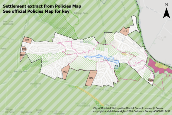
Settlement Hierarchy and Spatial Directions
- The village boundary is defined on the policies map and consists of the main settlement to the north of the A65 and on the edge of the Yorkshire Dales National Park. The focus for sustainable development of this medium village reflects its function and character balanced against its heritage and wider environmental constraints.
- The settlement features significant environmental constraints which focuses growth within its linear settlement form and boundary. Growth is constrained by its extensive historic core, A65 road to the south of the settlement and the River Wharfe to the northeast of the settlement.
- Development proposals should have regard to and be consistent with the made (adopted) Addingham Neighbourhood Development Plan where applicable.
Meeting Growth Needs
- Housing development includes releasing land within the settlement area and the Green Belt during the plan period and will:
- Deliver approximately 208 dwellings from new site allocations.
- Deliver housing site allocations as shown on the policies map and section 5:
- H11: Bolton Road
- H20: Land west of Turner Lane
- H21: Parsons Lane/Parsons Meadow
- H22: Land off St Pauls Rise
- H23: Land off Big Meadow Drive
- H24: Moor Lane
- H26: Church Street/Main Street
Table AD1.1 - Addingham
|
Under Construction |
Planning Permission |
Site Allocations |
|
|
Totals |
0 |
0 |
208 |
- Proposals for new homes within the settlement boundary on additional small sites, including the redevelopment of previously developed land, will be supported subject to meeting relevant Local Plan and Neighbourhood Development Plan policies.
Local Services and Facilities
- Support the range and quality of uses within the designated Addingham Local Centre as a key hub for the community to meet their day-to-day retail and leisure needs as well as the protection and enhancement of local services and facilities. This should also be in line with made (adopted) Neighbourhood Development Plan Policy ANDP7.
- Support the vibrancy and vitality of the Local Centre in line with Policy ANDP8 of the made (adopted) Neighbourhood Development Plan.
- Protect and enhance designated Local Green Spaces identified in Policy ANDP11 of the made (adopted) Neighbourhood Development Plan and designated open spaces in compliance with Policy NE2. Support proposals which address deficiencies in open space provision as set out in the Open Spaces Study. Seek opportunities to increase the provision of allotments, parks and gardens and areas of play where possible.
- Maintain and enhance sporting and recreation facilities, including those identified in Policy ANDP12 of the made (adopted) Neighbourhood Development Plan, and support widened community access.
Landscape
- Maintain the importance of the landscape in separating the settlement from Ilkley and preventing coalescence. Enhance the varied landscape character areas of the Wharfedale Rolling Enclosed Pasture and Wharfedale Settled Valley Floor and landscape features, fields and overall defined settlement pattern. Reference should be made to the Landscape Character Assessment Supplementary Planning Document.
- Proposals should minimise the influence of development in views to and from Nidderdale National Landscape.
- Development should have regard to impacts on the key views identified in the made (adopted) Neighbourhood Development Plan.
Historic and Natural Environment
- Protect and enhance strategic green and blue networks and corridors to enhance biodiversity and recreation within and adjacent to the settlement as well as incorporating sufficient green space and connections within new developments.
- Protecting and enhancing Green Infrastructure links through the village, in particular ensuring that new housing development proposed to the South of the settlement protects the landscape, setting and key views into the conservation area and provides significant enhancements in terms of access and ecology to the remaining open land north of the A65 Addingham Wharfedale Road.
- Protect and enhance Local Wildlife Sites as well as habitat networks and priority habitats within and adjacent to the settlement.
- The majority of the settlement is located within SPA/SAC Zone B (supporting habitat functionally linked land), whilst the northeastern section is within SPA/SAC Zone C (recreational pressure). Development proposals must assess potential impacts on foraging habitat used by SPA qualifying species and provide ecological evidence where required, as well as mitigate any recreational pressure on the SPA/SAC caused by such development in accordance with Policy NE3 and the South Pennine Moors SPD.
- Ensure that future development conserves and enhances key heritage assets and their settings within and adjacent to the settlement including the Conservation Area and Listed Buildings as well as non-designated heritage assets identified within Policy ANDP3 of the made (adopted) Neighbourhood Development Plan.
Local Infrastructure
- Support safe active travel routes to services and facilities, including connecting new development.
- Support and safeguard the route of the multi-path Wharfedale Greenway for cycling, walking and horse riding.
- Proportionate contributions to new or enhanced community infrastructure will be required, where appropriate, in line with Policies ID1 and ID2, Policy ANDP6 of the made (adopted) Neighbourhood Development Plan and the Local Infrastructure Plan.
Addingham: Site Allocations
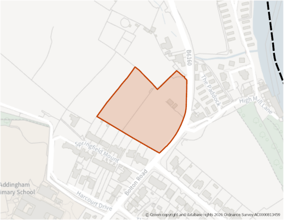
Site Size (ha) Gross: 1.24
Proposed Land Use: Housing
Minimum Development Capacity (Dwellings): 39
Site Type: Greenfield
Ward: Ilkley and Addingham
Settlement: Addingham
Ownership: Private
Delivery Timescale: Medium 2030-2035 (6-10)
Site Specific Requirements
Design Principles
- Development should provide at least 39 dwellings as part of a high-quality built environment in line with Policies ST4 and DS1, at a net density of 35 dph in line with Policy HO2. This should include affordable housing (in line with Policy HO4 and an appropriate mix of dwellings (in line with Policy HO3) and having due regard to relevant housing needs evidence and the character of the area.
- Design and layout should also reflect relevant policies within the “made” Addingham Neighourhood Development Plan.
- Enhancements to the surrounding Green Belt land should be made, including improving connections to offer opportunities for residents to access the countryside.
Site Access, Highways and Transport
- New site access from Bolton Road. East of the site is bounded by Bolton Road, with the potential new access leading onto the road between High Mill Lane and Bark Lane.
Flooding, Water and Drainage
- The site is more than 1ha in size. A Flood Risk and Drainage Assessment should be provided to identify any potential flood risk and appropriate measures for managing it.
Natural and Historic Environment
- The site lies within Zone C (Recreational Pressure) - Residential development resulting in a net increase in dwellings will be required to mitigate any recreational pressure on the SPA/SAC caused by such development in accordance with the South Pennine Moors SPD and Policy NE3.
- The adjacent TPO/woodland and 15m buffer at Land at High Mill Lane must be retained and protected. The design and layout of any development should ensure these trees are preserved and enhanced in line with Policy NE6. An arboricutural study should be provided as part of any planning application.
- North eastern site boundary is identified in the Local Nature Recovery Strategy (LNRS) with the preferred measure B2_M01: Create and maintain habitat corridors and stepping stones to connect and extend existing blue and green places.
- The site is located within a bat alert area. An ecological survey will be required as part of any planning application to establish the extent/impacts as well as to identify appropriate mitigation.
- Parts of the site are classed as Grade 3b and a small area to the north of the site is Grade 2 on the Agricultural Land Classification (ALC).
Environmental Protection
- The western corrner of the site is located within the 250m buffer of a former landfill site. A Land Contamination Assessment – Phase 1 Report will required as part of any planning application to identify any potential risk and appropriate mitigation measures.
- Site is within an outer area of Major Hazard Gas Pipe. Design and layout of any development should ensure that appropriate clearances are taken into consideration. Consultation should take place with the Health and Safety Executive and National Gas as appropriate.
- Eastern boundary of the site is partially a Mineral Safeguarding Area (MSA) for sand and gravel. A mineral assessment will be required as part of any planning application to determine the extent and availability of any sand and gravel resource.
- The site is adjacent to lower voltage electricity transmission lines across the north western boundary. Development should include a strategy for responding to the Northern Powergrid equipment present within the site which demonstrates how the Northern Powergrid and HSE Guidance have been applied as part of the design and layout and how the impact of the assets has been reduced through good design.
Open Space and Green / Blue Infrastructure
- Green and blue infrastructure should be provided in line with Policy NE1.
- Open space should be provided in line with Policy NE2, having regards to the standards set out in Appendix 11. The Open Space Assessment indicates that in Addingham there is a need for increased provision of allotments, parks and gardens and areas of play for older and younger children.
Landscape
- The site is within the Wharfedale Settled Valley Floor Landscape Character area/type (G4). Consideration should be given to the guidance set out in the Landscape Character Assessment SPD.
- The site is in an area of low moderate landscape sensitivity. Development should be located in the south of the site in proximity to the settlement edge. Avoid development along the adjacent roadway so as to minimise the perception of ribbon development and coalescence between dispersed residential properties further north. Trees and tree belts should be included to help integrate the development into the landscape, and hedgerow gaps filled, particularly along the western site boundary.
Green Belt (and Golden Rules)
- Site has been removed from the Green Belt. Development on the site should be consistent with the “Golden Rules” set out in the NPPF in relation to affordable housing, necessary improvements to infrastructure and accessible green space provision.
Infrastructure Requirements
- Proportionate contributions to community infrastructure will be required, where appropriate, in line with Policies ID1 and ID2, and having regard to the Local Infrastructure Plan.
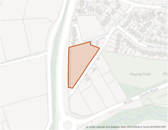
Site Size (ha) Gross: 0.61
Proposed Land Use: Housing
Minimum Development Capacity (Dwellings): 9
Site Type: Greenfield
Ward: Ilkley and Addingham
Settlement: Addingham
Ownership: Private
Delivery Timescale: Short 2025-2030 (1-5)
Site Specific Requirements:
- Development should provide at least 9 dwellings as part of a high-quality built environment in line with Policies ST4 and DS1, at a net density in line with Policy HO2. This should include affordable housing (in line with Policy HO4 and an appropriate mix of dwellings (in line with Policy HO3 and having due regard to relevant housing needs evidence and the character of the area).
- Design and layout should also reflect relevant policies within the “made” Addingham Neighourhood Development Plan.
- Site design and layout should retain boundary planting and walls. Enhancements to the surrounding Green Belt land should be made, including improving connections to offer opportunities for residents to access the countryside.
Site Access, Highways and Transport
- Turner Lane leads to a potential new access point however it is a narrow road that would require widening.
Natural and Historic Environment
- The site lies within Zone B (Supporting Habitat/Functionally Linked Land) – Development proposals must assess potential impacts on foraging habitat used by SPA qualifying species and provide ecological evidence where required, in accordance with the South Pennine Moors SPD and Policy NE3.
- TPO woodland around the site boundaries should be retained and protected.The design and layout of any development should ensure these trees are preserved and enhanced in line with Policy NE6. An arboricutural study should be provided as part of any planning application.
- Western boundary adjacent to Local Nature Recovery Strategy (LNRS) preferred measure T1_M01: Through natural processes and planting, create biodiverse, site-suitable, and adaptable woodland habitats to buffer and connect existing ancient woodlands and ancient/veteran trees.
- The majority of the site is within a bat alert area. An ecological survey will be required as part of any planning application to establish the extent/impacts as well as to identify appropriate mitigation.
- The majority of the site is classed as Grade 3b on the Agricultural Land Classification (ALC).
Open Space and Green / Blue Infrastructure
- Green and blue infrastructure should be provided in line with Policy NE1.
- Open space should be provided in line with Policy NE2, having regards to the standards set out in Appendix 11. The Open Space Assessment indicates that in Addingham there is a need for increased provision of allotments, parks and gardens and areas of play for older and younger children.
Landscape
- The site is within the Wharfedale Rolling Enclosed Pasture Landscape Character area/type (F2). No landscape sensitivity assessment was undertaken for this site. Consideration should be given to the guidance set out in the Landscape Character Assessment SPD.
Green Belt (and Golden Rules)
- Site has been removed from the Green Belt. However, the level of development proposed is below the threshold for the Golden Rules to apply.
Infrastructure Requirements
- Proportionate contributions to community infrastructure will be required, where appropriate, in line with Policies ID1 and ID2, and having regard to the Local Infrastructure Plan.
Planning Permission
- This site benefits from planning permission for 9 dwellings (22/03295/MAO). Approved on th 16/10/2025. This was after 1 April 2025 (the base date for the Local Plan). Accordingly, it has been identified as a site allocation. Development of this site should take place in line with the approved planning permission.
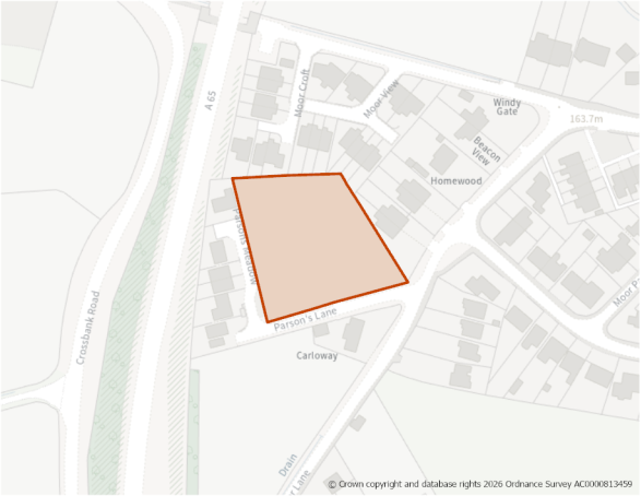
Site Size (ha) Gross: 0.39
Proposed Land Use: Housing
Minimum Development Capacity (Dwellings): 12
Site Type: Greenfield
Ward: Ilkley and Addingham
Settlement: Addingham
Ownership: Private
Delivery Timescale: Medium 2030-2035 (6-10)
Site Specific Requirements:
- Development should provide at least 12 dwellings as part of a high-quality built environment in line with Policies ST4 and DS1, at a net density of 35 dph in line with Policy HO2. This should include affordable housing (in line with Policy HO4 and an appropriate mix of dwellings (in line with Policy HO3 and having due regard to relevant housing needs evidence and the character of the area).
- Design and layout should also reflect relevant policies within the “made” Addingham Neighourhood Development Plan.
Site Access, Highways and Transport
- New site access required. There is a track leading from Parson's Lane to the site however this is too narrow and underdeveloped to be considered an existing access. Parson's Lane is also narrow.
Natural and Historic Environment
- The site lies within Zone B (Supporting Habitat/Functionally Linked Land). Development proposals must assess potential impacts on foraging habitat used by SPA qualifying species and provide ecological evidence where required, in accordance with the South Pennine Moors SPD and Policy NE3.
- TPO 15m buffer south eastern corner of site should be retained and protected. Additionally, adjacent TPO trees at Stonecroft, Turner Lane, Addingham should be retained and protected. The design and layout of any development should ensure these trees are preserved and enhanced in line with Policy NE6. An arboricutural study should be provided as part of any planning application.
- Boundary trees and traditional stone wall contribute to local street character and should be retained where possible with new planting.
Open Space and Green / Blue Infrastructure
- Green and blue infrastructure should be provided in line with Policy NE1.
- Open space should be provided in line with Policy NE2, having regards to the standards set out in Appendix 11. The Open Space Assessment indicates that in Addingham there is a need for increased provision of allotments, parks and gardens and areas of play for older and younger children.
Landscape
- The site is within the Wharfedale Rolling Enclosed Pasture Landscape Character area/type (F2). No landscape sensitivity assessment was undertaken for this site. Consideration should be given to the guidance set out in the Landscape Character Assessment SPD.
Infrastructure Requirements
- Proportionate contributions to community infrastructure will be required, where appropriate, in line with Policies ID1 and ID2, and having regard to the Local Infrastructure Plan.
H22: Land off St Pauls Rise, Addingham Comment
Site Boundary:
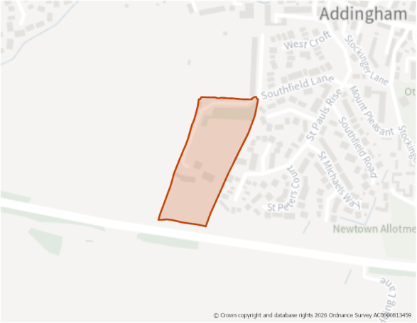
Site Size (ha) Gross: 2.37
Proposed Land Use: Housing
Minimum Development Capacity (Dwellings): 62
Site Type: Greenfield
Ward: Ilkley and Addingham
Settlement: Addingham
Ownership: Private
Delivery Timescale: Medium 2030-2035 (6-10)
Site Specific Requirements:
- Development should provide at least 62 dwellings as part of a high-quality built environment in line with Policies ST4 and DS1, at a net density of 35 dph in line with Policy HO2. This should include affordable housing (in line with Policy HO4 and an appropriate mix of dwellings (in line with Policy HO3 and having due regard to relevant housing needs evidence and the character of the area).
- Design and layout should also reflect relevant policies within the “made” Addingham Neighourhood Development Plan.
- Sensitive site design should be in keeping with the character of the surrounding area and take account of its proximity to Addingham Conservation Area. Protected hedgerows should be incorporated in to site design. Enhancements to the surrounding Green Belt land should be made, including improving connections to offer opportunities for residents to access the countryside.
Site Access, Highways and Transport
- There is a narrow existing access from Southfield Lane, to the north of the site. However, this is not wide enough and minimum access widths may not be achievable due to private property existing on either side. Therefore, a new access is required, which could be facilitated from St Paul's Rise.
- PRoW at northern site boundary to be retained and protected. The design and layout of any development should protect it and consider linkages to the wider network.
Flooding, Water and Drainage
- The site is wholly located within Flood Zone 1 of the Environment Agency's (EA) Flood Map for Planning which indicates it as at low risk of flooding from rivers. There is an area of surface water flood risk present along the northern boundary of the site. A site specific FRA will be required to ascertain the implications of this area of flood risk and ensure suitable mitigation measures can be put in place.
Natural and Historic Environment
- The site lies within Zone B (Supporting Habitat/Functionally Linked Land). Development proposals must assess potential impacts on foraging habitat used by SPA qualifying species and provide ecological evidence where required, in accordance with the South Pennine Moors SPD and Policy NE3.
- TPO Woodland and 15m buffer down eastern boundary of site must be retained and protected. Boundary trees, hedgerows and traditional stone wall contribute to local character and should be retained and enhanced. The design and layout of any development should ensure these trees are preserved and enhanced in line with Policy NE6. An arboricutural study should be provided as part of any planning application.
- Adjacent to Addingham conservation area to the north. The layout, design and scale of dwellings should have regard to the proximity of these designated heritage assets as well as the character of the surrounding area, taking into account the site’s topography, position in the landscape, and views into and out of the Conservation Area. Careful consideration of the landscape strategy will be needed.
- The southern site boundary is adjacent to Local Nature Recovery Strategy (LNRS) preferred measure T2 M04: Extend and connect tree and woodland cover across the White Rose Forest area in West Yorkshire, and preferred measure G1 M03: Restore and enhance existing species-rich grasslands.
- The majority of the site is located within a bat alert area. An ecological survey will be required as part of any planning application to establish the extent/impacts as well as to identify appropriate mitigation.
- Part of the site is classed as Grade 3b on the Agricultural Land Classification (ALC).
- A Heritage Impact Assessment (HIA) has been carried out for this site and concludes that its development would be acceptable and that mitigation should include the retention and reinforcement of the mixed native planting along all sides of the site. In addition, consideration must be given to the impact on the land gap between the site and housing allocation site H22, particularly in regard to ongoing viability and practical management of the agricultural land which forms part of and the setting of the conservation area.
Open Space and Green / Blue Infrastructure
- Green and blue infrastructure should be provided in line with Policy NE1.
- Open space should be provided in line with Policy NE2, having regards to the standards set out in Appendix 11. The Open Space Assessment indicates that in Addingham there is a need for increased provision of allotments, parks and gardens and areas of play for older and younger children.
Landscape
- The site is within the Wharfedale Rolling Enclosed Pasture Landscape Character area/type (F2) . Consideration should be given to the guidance set out in the Landscape Character Assessment SPD.
- A Landscape Sensitivity Assessment has been carried out for a larger area of land which includes this site. It indicates that the area has moderate-high landscape sensitivity. The full assessment indicates that development should be contained to the eastern-most and western-most areas of the larger site in proximity to the modern settlement edges and concentrated in the south towards the A65. Avoid development within or in proximity to the Conservation Area, or where development would be highly visible from the Conservation Area. Views from the Conservation Area towards the open pasture to the south are important to the rural setting and should be maintained, as noted in the Conservation Area assessment. Traditional drystone walls and hedgerows should be retained and integrated into new development where possible. Trees and tree belts should be included to help integrate the development into the landscape, and any existing vegetation protected and enhanced. Minimise development in views from the Dales Way, providing appropriate landscape buffer and enhancing the recreational experience and outward views along the route.
Green Belt (and Golden Rules)
- Site has been removed from the Green Belt. Development on the site should be consistent with the “Golden Rules” set out in the NPPF in relation to affordable housing, necessary improvements to infrastructure and accessible green space provision.
Infrastructure Requirements
- Proportionate contributions to community infrastructure will be required, where appropriate, in line with Policies ID1 and ID2, and having regard to the Local Infrastructure Plan.
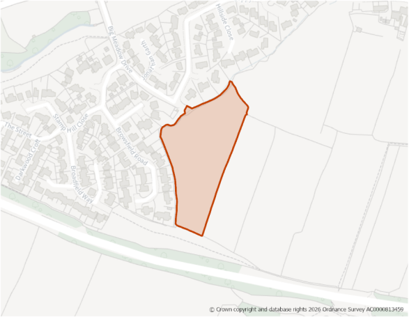
Site Size (ha) Gross: 1.62
Proposed Land Use: Housing
Minimum Development Capacity (Dwellings): 51
Site Type: Greenfield
Ward: Ilkley and Addingham
Settlement: Addingham
Ownership: Private
Delivery Timescale: Medium 2030-2035 (6-10)
Site Specific Requirements:
- Development should provide at least 51 dwellings as part of a high-quality built environment in line with Policies ST4 and DS1, at a net density of 35 dph in line with Policy HO2. This should include affordable housing (in line with Policy HO4 and an appropriate mix of dwellings (in line with Policy HO3 and having due regard to relevant housing needs evidence and the character of the area).
- Design and layout should also reflect relevant policies within the “made” Addingham Neighourhood Development Plan .
- Sensitive site design should be in keeping with the character of the surrounding area and take account of its proximity to Addingham Conservation Area. Enhancements to the surrounding Green Belt land should be made, including improving connections to offer opportunities for residents to access the countryside.
Site Access, Highways and Transport
- Site access is feasible to be built as an extension of Big Meadow Drive, to the west of the site.
- PRoW access to the south will need careful consideration. The design and layout of any development should protect it and consider linkages to the wider network and Addingham Neighbourhood Development Plan.
Flooding, Water and Drainage
- A nominal flood risk assessment has been carried out for this site. It indicates that the site is wholly located within Flood Zone 1 of the Environment Agency's (EA) Flood Map for Planning which indicates it as at low risk of flooding from rivers. Development should be possible at this site given the low fluvial and very low surface water flood risk to the site.
- The site is not modelled to be at significant additional fluvial or surface water risk as a result of climate change. Any FRA should include for a drainage strategy which includes the flow path in site design and investigate ground conditions for infiltration SuDS suitability.
Natural and Historic Environment
- The site lies within Zone B (Supporting Habitat/Functionally Linked Land). Development proposals must assess potential impacts on foraging habitat used by SPA qualifying species and provide ecological evidence where required, in accordance with the South Pennine Moors SPD and Policy NE3.
- TPO Woodland and 15m buffer down eastern boundary of site and mature trees and hedgerows should be retained. The design and layout of any development should ensure these trees are preserved and enhanced in line with Policy NE6. An arboricutural study should be provided as part of any planning application.
- Adjacent to Addingham conservation area to the north.The layout, design and scale of dwellings should have regard to the proximity of these designated heritage assets as well as the character of the surrounding area, taking into account the site’s topography, position in the landscape, and views into and out of the Conservation Area. Careful consideration of the landscape strategy will be needed.
- The majority of the site is within a bat alert area. An ecological survey will be required as part of any planning application to establish the extent/impacts as well as to identify appropriate mitigation.
- Southern site boundary is adjacent to Local Nature Recovery Strategy (LNRS) identified preferred measure T2_M04: Extend and connect tree and woodland cover across the White Rose Forest area in West Yorkshire.
- Part of the site is classed as Grade 3b on the Agricultural Land Classification (ALC).
- A Heritage Impapct Assessment (HIA) has been carried out for a slightly larger site and concludes that development would result in a heritage impact of less than substantial harm of an acceptable level. Suitable mitigation will need to be incorporated into any scheme and should include enhancement of the existing field edge planting to provide a proper belt of shrubs and trees which would soften the impact of development and would assist in its integration into the landscape and further reduce any visible impact on the conservation area and its setting. In addition, consideration must be given to the impact on the land gap between the site and housing allocation site H23, particularly in regard to ongoing viability and practical management of the agricultural land which forms part of and the setting of the conservation area.
Environmental Protection
- Site falls partly within 250m buffer of former landfill. A Land Contamination Assessment – Phase 1 Report will required as part of any planning application to identify any potential risk and appropriate mitigation measures.
Open Space and Green / Blue Infrastructure
- Green and blue infrastructure should be provided in line with Policy NE1.
- Open space should be provided in line with Policy NE2, having regard to the standards set out in Appendix 11. The Open Space Assessment indicates that in Addingham there is a need for increased provision of allotments, parks and gardens and areas of play for older and younger children.
Landscape
- The site is within the Wharfedale Rolling Enclosed Pasture Landscape Character area/type (F2) . Consideration should be given to the guidance set out in the Landscape Character Assessment SPD.
- A Landscape Sensitivity Assessment has been carried out for a larger area of land which includes this site. It indicates that the area has moderate-high landscape sensitivity. The full assessment indicates that development should be contained to the eastern-most and western-most areas of the larger site in proximity to the modern settlement edges and concentrated in the south towards the A65. Avoid development within or in proximity to the Conservation Area, or where development would be highly visible from the Conservation Area. Views from the Conservation Area towards the open pasture to the south are important to the rural setting and should be maintained, as noted in the Conservation Area assessment. Traditional drystone walls and hedgerows should be retained and integrated into new development where possible. Trees and tree belts should be included to help integrate the development into the landscape, and any existing vegetation protected and enhanced. Minimise development in views from the Dales Way, providing appropriate landscape buffer and enhancing the recreational experience and outward views along the route.
Green Belt (and Golden Rules)
- Site has been removed from the Green Belt. Development on the site should be consistent with the “Golden Rules” set out in the NPPF in relation to affordable housing, necessary improvements to infrastructure and accessible green space provision.
Infrastructure Requirements
- Proportionate contributions to community infrastructure will be required, where appropriate, in line with Policies ID1 and ID2, and having regard to the Local Infrastructure Plan.
H24: Moor Lane, Addingham Comment
Site Boundary:
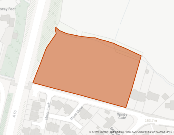
Site Size (ha) Gross: 0.95
Proposed Land Use: Housing
Minimum Development Capacity (Dwellings): 27
Site Type: Greenfield
Ward: Ilkley and Addingham
Settlement: Addingham
Ownership: Private
Delivery Timescale: Short 2025- 2030 (1-5)
Site Specific Requirements:
- Development should provide at least 27 dwellings as part of a high-quality built environment in line with Policies ST4 and DS1, at a net density in line with Policy HO2. This should include affordable housing (in line with Policy HO4 and an appropriate mix of dwellings (in line with Policy HO3 and having due regard to relevant housing needs evidence and the character of the area).
- Design and layout should also reflect relevant policies within the “made” Addingham Neighourhood Development Plan.
- Enhancements to the surrounding Green Belt land should be made, including improving connections to offer opportunities for residents to access the countryside.
Site Access, Highways and Transport
- Acess to the site is available via the existing field access from Moor Lane,which is unadopted and would need improvement. South of the site is bounded by Moor Lane which has sufficient width for two-way traffic. The new access road would link to Moor Lane.
Natural and Historic Environment
- The site lies within Zone B (Supporting Habitat/Functionally Linked Land) – Development proposals must assess potential impacts on foraging habitat used by SPA qualifying species and provide ecological evidence where required, in accordance with the South Pennine Moors SPD and Policy NE3.
- Mature trees and traditional dry stone wall along boundaries contribute to local character and should be retained.
- The western boundary of the site is identified in the Local Nature Recovery Strategy (LNRS) with preferred measure T2_M04: Extend and connect tree and woodland cover across the White Rose Forest area in West Yorkshire.
- The site is partly located within a bat alert area. An ecological survey will be required as part of any planning application to establish the extent/impacts as well as to identify appropriate mitigation.
- Part of the site is classed as Grade 3b on the Agricultural Land Classification (ALC).
Open Space and Green / Blue Infrastructure
- Green and blue infrastructure should be provided in line with Policy NE1.
- Open space should be provided in line with Policy NE2, having regards to the standards set out in Appendix 11. The Open Space Assessment indicates that in Addingham there is a need for increased provision of allotments, parks and gardens and areas of play for older and younger children.
Landscape
- The site is within the Wharfedale Rolling Enclosed Pasture Landscape Character area/type (F2). Consideration should be given to the guidance set out in the Landscape Character Assessment SPD.
- The site is part of an area of moderate landscape sensitivity. Avoid development on the more elevated slopes to the west, and locate any development in proximity to the existing settlement edge to the east, along the south-eastern site boundary. Provide additional landscape buffer and planting to soften the settlement edge, integrating any development into the wider landscape. Traditional drystone walls and hedgerows should be retained and integrated into new development where possible. Any existing vegetation should be protected and enhanced. Minimise development in views from the Millennium Way and Dales Way, providing appropriate landscape buffer and enhancing the recreational experience and outward views along the routes.
Other Constraints
- Addingam NDP Views and Vistas across site. Mitigate potential impact upon the open field character and external views.
Green Belt (and Golden Rules)
- Site has been removed from the Green Belt. Development on the site should be consistent with the “Golden Rules” set out in the NPPF in relation to affordable housing, necessary improvements to infrastructure and accessible green space provision.
Infrastructure Requirements
- Proportionate contributions to community infrastructure will be required, where appropriate, in line with Policies ID1 and ID2, and having regard to the Local Infrastructure Plan.
Planning Permission
- 25/02043/MAO Outline application for residential development of land for 27 dwellings requesting consideration of scale, layout access and appearance. This was after 1 April 2025 (the base date for the Local Plan). Accordingly, it has been identified as a site allocation. Development of this site should take place in line with the approved planning permission.
H26: Church Street/Main Street, Addingham Comment
Site Boundary:
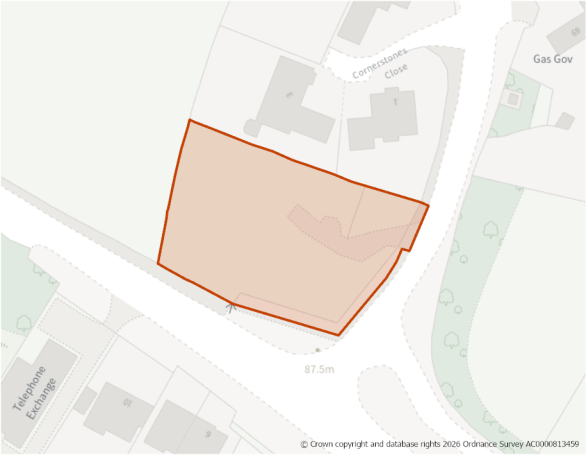
Site Size (ha) Gross: 0.24
Proposed Land Use: Housing
Minimum Development Capacity (Dwellings): 8
Site Type: PDL
Ward: Ilkley and Addingham
Settlement: Addingham
Ownership: Private
Delivery Timescale: Short 2025-2030 (1-5)
Site Specific Requirements:
- Development should provide at least 8 dwellings as part of a high-quality built environment in line with Policies ST4 and DS1, at a net density of 35 dph in line with Policy HO2. This should include affordable housing (in line with Policy HO4 and an appropriate mix of dwellings (in line with Policy HO3 and having due regard to relevant housing needs evidence and the character of the area).
- Design and layout should also reflect relevant policies within the “made” Addingham Neighourhood Development Plan .
- Sensitive site design should be in keeping with the character of the surrounding area and take account of its proximity to Addingham Conservation Area.
Site Access, Highways and Transport
- Provide a new access from Church Street to the east.
Flooding, Water and Drainage
- The site was included in the Level 1 Strategic Flood Risk Assessment, however no further risk assessment has been carried out. The site is wholly located within Flood Zone 1 of the Environment Agency's (EA) Flood Map for Planning which indicates it is at low risk of flooding from rivers. There is an area of surface water flood risk present in the centre of the site. Development should be possible at this site given the low fluvial and low surface water flood risk to the site. Any FRA should include a drainage strategy which looks at the surface water flow path as part of the site design and investigate ground conditions for infiltration SuDS suitability.
Natural and Historic Environment
- The site lies within Zone B (Supporting Habitat/Functionally Linked Land) – Development proposals must assess potential impacts on foraging habitat used by SPA qualifying species and provide ecological evidence where required, in accordance with the South Pennine Moors SPD and Policy NE3.
- Mature trees along the boundary, especially along the front that contribute to the local street character and those to the rear (west), should be retained.The site should retain as many trees as possible to dilute the visual impact. Landscaping responding to local distinctiveness would be required along all edges of the site to ensure integration into its context. In the expectation of any development not appearing strident or discordant, the effect on the conservation area, particularly in respect of the setting of Hallcroft Hall, should strive to cause no harm.The layout, design and scale of dwellings should have regard to the proximity of these designated heritage assets as well as the character of the surrounding area, taking into account the site’s topography, position in the landscape, and views into and out of the Conservation Area. Careful consideration of the landscape strategy will be needed.
- Design should be sensitive to adjacent TPO woodland 15m buffer Hallcroft Hall , along the eastern boundary. The design and layout of any development should ensure these trees are preserved and enhanced in line with Policy NE6. An arboricutural study should be provided as part of any planning application.
- The north eastern corner of the site identified in the Local Nature Recovery Strategy (LNRS) with preferred measure B2_M01: Create and maintain habitat corridors and stepping stones to connect and extend existing blue and green places, and preferred measure T1 M01: Through natural processes and planting, create biodiverse, site-suitable, and adaptable woodland habitats to buffer and connect existing ancient woodlands and ancient/veteran trees.
- The site is located within a bat alert area. An ecological survey will be required as part of any planning application to establish the extent/impacts as well as to identify appropriate mitigation.
- Part of the site is classed as Grade 2 on the Agricultural Land Classification (ALC).
Environmental Protection
- Site is located within Sand and Gravel Mineral Safeguarding Area. A mineral resource assessment will be required as part of any planning application to determine the extent and availability of any Sand and Gravel resource.
Open Space and Green / Blue Infrastructure
- Green and blue infrastructure should be provided in line with Policy NE1.
- Open space should be provided in line with Policy NE2, having regards to the standards set out in Appendix 11.
Landscape
- The site is within the Wharfedale Settled Valley Floor Landscape Character area/type (G4). No landscape sensitivity assessment was undertaken for this site. Consideration should be given to the guidance set out in the Landscape Character Assessment SPD.
Infrastructure Requirements
- Proportionate contributions to community infrastructure will be required, where appropriate, in line with Policies ID1 and ID2, and having regard to the Local Infrastructure Plan.
POLICY BU1 – BURLEY IN WHARFEDALE Comment
Settlement Plan:
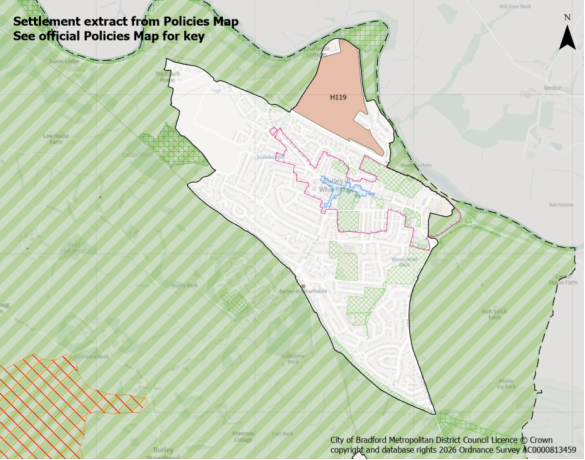
Settlement Hierarchy and Spatial
- The village boundary is defined on the policies map and consists of the main settlement to the south of the A65 and land to the north adjacent to the River Wharfe corridor.
- The focus for sustainable development of this large village is reflective of its sustainable location with public transport connections including a railway station and range of services and facilities balanced against the importance of its historic centre with designated heritage assets and wider environmental constraints.
- The settlement features a western residential extension at Sun Lane and a growth area to the north for sport facilities, recreation and housing uses.
- Further development outside of settlement boundary to the western and eastern / south-eastern of Burley in Wharfedale should be avoided to preserve the settlement setting and character and avoid coalescence with neighbouring settlements within the valley corridor.
- Development proposals should also have regard to and be consistent with the made (adopted) Burley in Wharfedale Neighbourhood Development Plan where applicable.
Meeting Growth Needs
- Housing development includes releasing land within the settlement area and the Green Belt during the plan period and will:
- Deliver approximately 577 dwellings through a combination of sites under construction, planning permissions and a new site allocation as set out in Table BU1.1.
- Deliver the housing site allocation as shown on the policies map and the site proforma within section 5:
- H119: Great Pasture Lane
Table BU1.1 - Burley in Wharfedale:
|
Under Construction |
Planning Permission |
Site Allocations |
|
|
Totals |
476 |
1 |
100 |
- Proposals for new homes within the settlement boundary on additional small sites, including the redevelopment of previously developed land, will be supported subject to meeting relevant policies.
- Development proposals should provide for a balanced range of housing including senior and affordable housing.
Local Services and Facilities
- Support the vitality and viability of the designated Local Centre with its the range and quality of uses acting as a key hub for the community to meet their day-to-day retail and leisure needs as well as the retention and improvement of local services and facilities.
- Protect and enhance designated Local Green Spaces as identified in Policy BW11 of the made (adopted) Neighbourhood Development Plan.
- Protect designated open spaces in compliance with Policy NE2 and support proposals which address deficiencies in open space provision as set out on the Open Spaces Study.
- Maintain, enhance and widen sport and recreation pitches and facilities with support for physical improvements to enhance participation rates.
Landscape
- Maintain the importance of the landscape in separating the settlement from Menston and Ilkley and preventing coalescence together with enhancing the landscape setting with its valley floor landscape character area, landscape features, fields and overall settlement pattern.
- Proposals should minimise the influence of development in views to and from Nidderdale National Landscape.
Historic and Natural Environment
- Protect and enhance strategic green and blue networks and corridors and address deficiencies in provision to enhance biodiversity and recreation within and adjacent to the settlement as well as incorporating sufficient green space and connections within new developments.
- Maintain a strong focus upon engraining green infrastructure and new and enhanced open space within new residential developments.
- Protect and enhance the designated Local Nature Reserve, Local Wildlife Sites as well as habitat networks, priority habitats and irreplaceable habitats adjacent to the settlement.
- The majority of the settlement is located within SPA/SAC Zone B (supporting habitat functionally linked land), whilst the northern section is within SPA/SAC Zone C (recreational pressure). Development proposals must assess potential impacts on foraging habitat used by SPA qualifying species and provide ecological evidence where required, as well as mitigate any recreational pressure on the SPA/SAC caused by such development in accordance with Policy NE3 and the South Pennine Moors SPD.
- Ensure that future development conserves key heritage assets and their settings within and adjacent to the settlement including the Conservation Area and Listed Buildings and local heritage assets.
Local Infrastructure
- Support safe active travel routes to services and facilities and the railway station, including connecting new development.
- Support and safeguard the route of the multi-path Wharfedale Greenway for cycling, walking and horse riding.
- Proportionate contributions to new or enhanced community infrastructure will be required, where appropriate, in line with Policies ID1 and ID2, and having regard to the Local Infrastructure Plan.
Burley in Wharfedale: Site Allocations
H119: Great Pasture Lane, Burley Comment
Site Boundary:
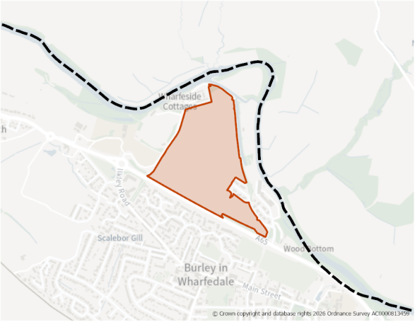
Site Size (ha) Gross: 18.26
Proposed Land Use: Housing
Minimum Development Capacity (Dwellings): 100
Site Type: Greenfield
Ward: Wharfedale
Settlement: Burley
Ownership: Private
Delivery Timescale: Medium 2030-2035 (6-10)
Site Specific Requirements:
- Development should provide at least 100 dwellings as part of a high-quality built environment in line with Policies ST4 and DS1, at a net density of 35 dph in line with Policy HO2. This should include affordable housing (in line with Policy HO4 and an appropriate mix of dwellings (in line with Policy HO3 and having due regard relevant housing needs evidence and the character of the area).
- New housing development should be located in the east side of the site, in proximity to existing residential developments and where the site is well-enclosed by mature roadside vegetation and landform. Proposals should minimise the influence of development in views to and from the National Landscape.
- The design and layout should also reflect relevant policies within the made (adopted) Burley in Wharfedale Neighbourhood Development Plan.
Site Access, Highways and Transport
- A new site access would be required from the A65.
Flooding, Water and Drainage
- The development should be designed to take into account areas of Flood Zone 2 to the northeast of the site.
Natural and Historic Environment
- The site lies within Zone B (Supporting Habitat/Functionally Linked Land) - Development proposals must assess potential impacts on foraging habitat used by SPA qualifying species and provide ecological evidence where required, in accordance with the South Pennine Moors SPD and Policy NE3.
- The site boundary should take account of the washlands habitat network in the north east corner of the site.The site is also located within a bat alert area. An ecological survey will be required as part of any planning application to establish the extent/impacts as well as to identify appropriate mitigation.
- The site boundary should take account of the TPO buffer to the east of the site.
- The site is identified in the LNRS with the preferred measureT2_M04: Extend and connect tree and woodland cover across the White Rose Forest area in West Yorkshire.
- The site is located within a bat alert area. An ecological survey will be required as part of any planning application to establish the extent/impacts as well as to identify appropriate mitigation.
Environmental Protection
- The site is partially located within a 250m buffer of a former landfill site.
- Site is within/partially within a Mineral Safeguarding Area (MSA) for Sand and Gravel. A mineral resource assessment will be required as part of any planning application to determine the extent and availability of any Sand and Gravel resource.
Open Space and Green / Blue Infrastructure
- Site is partially within an area of medium provision and high need for green and blue infrastructure. Development proposals should focus on carefully designed green and blue infrastructure to contribute towards site specific issues e.g. flood mitigation, urban cooling etc.
- The Open Space Assessment identifies a need to secure the provision of Amenity Greenspace within new developments, particularly where such provision can connect with existing open spaces and contribute to the wider Green Infrastructure network. The Assessment also highlights deficiencies in Natural and Semi-natural Greenspace and outdoor sports provision within the settlement, which should be taken into account when considering opportunities for new open space provision. Open space should be provided in line with Policy NE2, having regards to the standards set out in Appendix 11.
Landscape
- The site is located within the Wharfedale Settled Valley Floor Landscape Character area/type (G4).
- Development should be located in the east of the site, in proximity to existing residential developments and where the site is wellenclosed by mature roadside vegetation and landform. Minimise the influence of development in views to and from the AONB. Traditional drystone walls and hedgerows should be retained and integrated into new development. Trees and tree belts should be included to help integrate the development into the landscape, and any existing vegetation protected and enhanced.
Green Belt (and Golden Rules)
- Site has been removed from the Green Belt. Development on the site should be consistent with the “Golden Rules” set out in the NPPF in relation to affordable housing, necessary improvements to infrastructure and accessible green space provision.
Infrastructure Requirements
- Proportionate contributions to community infrastructure will be required, where appropriate, in line with Policies ID1 and ID2, and having regard to the Local Infrastructure Plan.
POLICY IL1 – ILKLEY Comment
Settlement Plan:
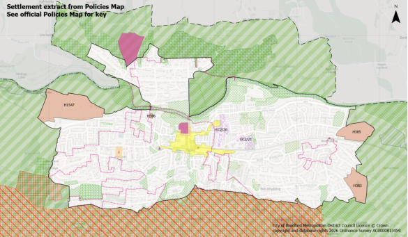
Settlement Hierarchy and Spatial Directions
- The town boundary is defined on the Policies Map and the focus for sustainable development of this medium town with public transport and rail connections supporting a wider catchment for services and facilities, is a balanced approach to growth considering its spa town character, heritage and wider environmental constraints.
- The settlement generally has a linear built form, and growth is constrained by a large historic core, Ilkley Moor to the south and the River Wharfe and a significant cluster of environmental assets to the north.
- Housing growth is focused upon limited infill, and settlement boundary extensions to western and eastern edges with services and facilities within reasonable walking distance, including public transport connections.
- Further development outside of settlement boundary to the west and east of Ilkley should be avoided to preserve the settlement setting and character and avoid coalescence with neighbouring settlements within the valley corridor.
- Development proposals should also have regard to and be consistent with the Ilkley Neighbourhood Development Plan where applicable.
Meeting Growth Needs
- Housing development includes a combination of development within the settlement boundary and land to be released from the Green Belt during the plan period and will:
- Deliver approximately 689 dwellings through a combination of sites under construction, planning permissions and new site allocations as set out in Table IL1.1.
- Deliver housing site allocations as shown on the policies map and the site proformas within section 5:
- H1547: Land north of Skipton Road (Hadfield Farm): - H383: Land off Wheatley Grove
- H385: Land east of Wheatley Lane as se
- H386: Stockheld Road
Table IL1.1 - Ilkley:
|
Under Construction |
Planning Permission |
Site Allocations |
|
|
Totals |
70 |
26 |
593 |
- Proposals for new homes within the settlement boundary on additional small sites, including the redevelopment of previously developed land, will be supported subject to meeting relevant policies.
- Employment uses will continue to be concentrated within the town centre and employment zones EC2/20 (Golden Butts Road / East Parade) and EC2/21 (Lower Railway Road) areas of the town as shown on the Policies Map.
- Continue to support visitor and tourism facilities and services of an appropriate scale compatible with the historic character and function of the settlement to support local employment.
Local Services and Facilities
- Support the range and quality of uses within the designated Town Centre as a key hub for the community and visitors to meet day-to-day retail and leisure needs as well as the retention and improvement of local services and facilities.
- Support the diverse mix of retail, leisure and cultural uses and strong independent business sector and established visitor attractions together with maintaining the high-quality environment, public realm, and distinctive character.
- Protect and enhance designated Local Green Spaces as identified in Policy INDP10 of the adopted Neighbourhood Development Plan and support proposals which address deficiencies in open space provision as set out on the Open Spaces Study in compliance with Policy NE2.
Landscape
- Maintain the importance of the landscape in separating the settlement from Addingham and Burley in Wharfedale and preventing coalescence together with enhancing the varied landscape character areas, landscape features, fields and overall defined settlement pattern.
- Integrate development within the wider landscape setting through retaining existing features, screening, trees belts and alignment with the edge of established built form.
- Proposals should minimise the influence of development in views to and from Nidderdale National Landscape.
Historic and Natural Environment
- Protect and enhance strategic green and blue networks and corridors within and adjacent to the settlement, addressing deficiencies in provision, as well as incorporating sufficient green space and connections within new developments.
- Protect and enhance the designated National Nature Reserve adjacent to the south of the settlement, Local Nature Reserves, Local Wildlife Sites and Local Geological Sites as well as habitat networks and priority habitats within and adjacent to the settlement. Development proposals should also pay particular attention to avoiding impact on the South Pennine Moors Site of Special Scientific Interest towards the south of the settlement and Bradford Pennine Gateway NNR.
- The South Pennine Moors SPA/SAC is located directly to the south of the settlement. In accordance with Policy NE3 and the South Pennine Moors SPD, in Zone A (400m from the edge of the Moor), no residential development resulting in a net increase in dwellings will be permitted.
- Where development is located within SPA/SAC Zone B (supporting habitat functionally linked land) residential development proposals must assess potential impacts on foraging habitat used by SPA qualifying species and provide ecological evidence where required, in accordance with the South Pennine Moors SPD and Policy NE3.
- Where development is located within SPA/SAC Zone C (recreational pressure) residential development resulting in a net increase in dwellings will be required to mitigate any recreational pressure on the SPA/SAC caused by such development in accordance with POlicy NE3 and the South Pennine Moors SPD.
- Proposals for development should ensure that they conserve key heritage assets and their settings within and adjacent to the settlement including the three Conservation Areas and Listed Buildings as well as non-designated heritage assets.
Local Infrastructure
- Support improvements and access to public transport and safe active travel routes to services and facilities, including enhanced links to Ilkley stations.
- Support and safeguard the route of the multi-path Wharfedale Greenway for cycling, walking and horse riding.
- Support climate change mitigation, including natural flood risk management schemes around Backstone Beck.
- Proportionate contributions to new or enhanced community infrastructure will be required, where appropriate, in line with Policies ID1 and ID2, and having regard to the Local Infrastructure Plan.
- Where appropriate funding and delivery opportunities are available support investment in Ilkley Pool and Lido.
Ilkley: Site Allocations
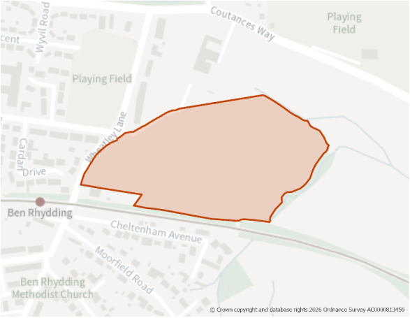
H383: Land off Wheatley Grove, Ilkley Comment
Site Boundary:
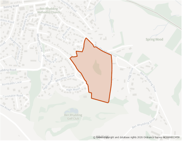
Site Size (ha) Gross: 7.17
Proposed Land Use: Housing
Minimum Development Capacity (Dwellings): 125
Site Type: Greenfield
Ward: Ilkley & Addingham
Settlement: Ilkley
Ownership: Private
Delivery Timescale: Medium 2030-2035 (6-10)
Site Specific Requirements:
- Development should provide at least 125 dwellings as part of a high-quality built environment in line with Policies ST4 and DS1, at a net density of 35 dph in line with Policy HO2. This should include affordable housing (in line with Policy HO4 and an appropriate mix of dwellings (in line with Policy HO3 and having due regard relevant housing needs evidence and the character of the area).
- The design and layout should also reflect relevant policies within the made (adopted) Ilkley Neighbourhood Development Plan.
Site Access, Highways and Transport
- Access to the site is available from Wheatley Grove, which would require a new access. Access is not considered available from Ben Rhydding Drive.
Flooding, Water and Drainage
- Any FRA should include for a drainage strategy which should investigate ground conditions for infiltration SuDS suitability.
Natural and Historic Environment
- A small part of the site along its western edge falls within Zone A (Urban Edge Effects) where no residential development must take place. The majority of the site lies within Zone B (Supporting Habitat/Functionally Linked Land) - Development proposals must assess potential impacts on foraging habitat used by SPA qualifying species and provide ecological evidence where required, in accordance with the South Pennine Moors SPD and Policy NE3.
- The site is located within a bat alert area. An ecological survey will be required as part of any planning application to establish the extent/impacts as well as to identify appropriate mitigation.
- The site is almost completely covered with grassland habitat and contains areas with TPO woodland. The site is also within a bat alert area. An ecological survey will be required as part of any planning application to establish the extent/impacts as well as to identify appropriate mitigation.
- It is likely that the development of the site can be undertaken without harm to the significance or setting of the nearby designated heritage assets.
- Development of the site will need to be informed by and respond to the nearby development. It is likely that the layout, design and scale of dwellings within the site should take design cues from the nearby traditional and/or high quality buildings and that this should also be reflected in the materials. Careful consideration of the landscape strategy including retention of the existing trees will be needed. Where existing stone boundary walls exist, these should also be incorporated to ensure that this element of the rural character of the site is retained.
- The site is identified in the LNRS with the preferred measure G1_M03: Restore and enhance existing species-rich grasslands.
Open Space and Green / Blue Infrastructure
- The Open Space Assessment identifies a need to secure the provision of Amenity Greenspace within new developments, particularly where such provision can connect with existing open spaces and contribute to the wider Green Infrastructure network. The Assessment also highlights deficiencies in the provision of allotments, children's play areas, open land in settlements and parks and gardens within the settlement, which should be taken into account when considering opportunities for new open space provision. Open space should be provided in line with Policy NE2, having regards to the standards set out in Appendix 11.
- Site is partially within an area of low provision and medium need for green and blue infrastructure. Development proposals should focus on carefully designed green and blue infrastructure to contribute towards site specific issues e.g. flood mitigation, urban cooling etc.
Landscape
- The site is located within the Wharfedale Rolling Enclosed Pasture Landscape Character area/type (F2).
- Development should be located across the northern edge of the site, away from the more elevated extents to the south. Hedgerows should be retained and integrated into new development where possible. Trees and tree belts should be included to help integrate the development into the landscape. Existing vegetation, particularly intact copses of trees within the site, should be protected and enhanced.
Green Belt (and Golden Rules)
- Site has been removed from the Green Belt. Development on the site should be consistent with the “Golden Rules” set out in the NPPF in relation to affordable housing, necessary improvements to infrastructure and accessible green space provision.
Infrastructure Requirements
- Proportionate contributions to community infrastructure will be required, where appropriate, in line with Policies ID1 and ID2, and having regard to the Local Infrastructure Plan.
Site Size (ha) Gross: 7.41
Proposed Land Use: Housing
Minimum Development Capacity (Dwellings): 200
Site Type: Greenfield
Ward: Ilkley & Addingham
Settlement: Ilkley
Ownership: Public
Delivery Timescale: Long 2035+ (11+)
Site Specific Requirements:
- Development should provide at least 200 dwellings as part of a high-quality built environment in line with Policies ST4 and DS1, at a net density of 75 dph in line with Policy HO2. This should include affordable housing (in line with Policy HO4 and an appropriate mix of dwellings (in line with Policy HO3 and having due regard relevant housing needs evidence and the character of the area).
- The design and layout should also reflect relevant policies within the made (adopted) Ilkley Neighbourhood Development Plan.
Site Access, Highways and Transport
- Access to the site is available from the existing field access point from Wheatley Lane, which would need improvement. Further highways assessment is required given the scale of site.
Flooding, Water and Drainage
- Based on the evidence presented in the Level 1 SFRA (2023) and Level 2 SFRA recommends that there should be no development within the existing area of functional floodplain present on site. Development should be directed away from the northeast of the site modelled to be at fluvial flood risk.
- Historic mapping indicates there may be a watercourse culverted along the northwestern site boundary, as well as two other watercourses perpendicular to the northern and southern site boundaries. If present, culverts represent potential residual risk of flooding to the site through culvert failure or blockage. This will need to be further investigated and modelled at the FRA stage. Modelling should include residual risk assessment and options for culvert removal. No development should take place over the top of a culvert nor within 8m either side of the culverted section of watercourse. Assuming culverts are located beneath the site, opportunities for opening up the culverts should be explored for inclusion in site design as a blue green corridor. This would remove any residual risk of flooding to the site as a result of culvert failure or blockage. Safe access and escape routes during the medium risk plus climate change event must be considered further as part of a site-specific FRA. Any FRA should consider undertaking detailed 2D flood modelling of the River Wharfe in this location to understand the onsite hazards and velocities associated with a flood event. The unnamed watercourse may also require modelling.
Natural and Historic Environment
- The site lies within Zone B (Supporting Habitat/Functionally Linked Land) - Development proposals must assess potential impacts on foraging habitat used by SPA qualifying species and provide ecological evidence where required, in accordance with the South Pennine Moors SPD and Policy NE3.
- The site is located within a bat alert area. An ecological survey will be required as part of any planning application to establish the extent/impacts as well as to identify appropriate mitigation.
- The site contains a narrow area of woodland habitat where there are existing hedgerows and is adjacent to an area of TPO woodland to the east. The site is also wholly within a bat alert area. An ecological survey will be required as part of any planning application to establish the extent/impacts as well as to identify appropriate mitigation.
- Consideration has been given to whether partial development of the site would be feasible without causing unacceptable harm to the setting of the heritage assets. However the configuration of the site, its openness without any existing screening from the heritage assets, and its relationship with the assets, preclude development of any part without having comparable harmful impact as that which would derive from entire development. Landscape buffer planting would appear incongruous in this otherwise open environment. However, the wider public and sustainability benefits provided by the sensitive (re)development of the site are such that its allocation in the plan is considered a necessary part of the development strategy for the settlement. A more detailed HIA, for the specific proposed scheme will need to be carried out at the planning application stage working closely with the Council’s Heritage team, to develop appropriate mitigation measures to reduce the harm as much as is possible.
- The site is identified in the LNRS with the preferred measures B4_M02: Significantly boost biodiversity wherever possible where there are existing habitats alongside transport infrastructure, and T2_M01: Buffer and connect existing woodlands by creating new riparian habitats that will also support many different species.
Environmental Protection
- Site is partially within a Mineral Safeguarding Area (MSA) for Sand and Gravels. A mineral resource assessment will be required as part of any planning application to determine the extent and availability of any Sand and Gravels resource.
Open Space and Green / Blue Infrastructure
- The Open Space Assessment identifies a need to secure the provision of Amenity Greenspace within new developments, particularly where such provision can connect with existing open spaces and contribute to the wider Green Infrastructure network. The Assessment also highlights deficiencies in the provision of allotments, children's play areas, open land in settlements and parks and gardens within the settlement, which should be taken into account when considering opportunities for new open space provision. Open space should be provided in line with Policy NE2, having regards to the standards set out in Appendix 11.
- Site is partially within an area of high provision and high need for green and blue infrastructure. Development proposals should focus on carefully designed green and blue infrastructure to contribute towards site specific issues e.g. flood mitigation, urban cooling, etc.
Landscape
- The site is located within the Wharfedale Settled Valley Floor Landscape Character area/type (G4).
- Development should be located along the western edge of the site, contiguous with existing residential development north of the site along the eastern edge of the B6382. Provide sufficient and appropriate landscape buffer to any new development, which would screen and integrate modern development into the wider landscape, and soften the existing abrupt settlement edge.
- Retain in-field trees, providing suitable and appropriate buffer. Repair and enhance drystone walls where possible. Minimise development in views from the Nidderdale AONB and from the northern edge of Ilkley Moor and popular tourist locations.
Green Belt (and Golden Rules)
- Site has been removed from the Green Belt. Development on the site should be consistent with the “Golden Rules” set out in the NPPF in relation to affordable housing, necessary improvements to infrastructure and accessible green space provision.
Infrastructure Requirements
- Proportionate contributions to community infrastructure will be required, where appropriate, in line with Policies ID1 and ID2, and having regard to the Local Infrastructure Plan.
H386: Stockeld Road, Ilkley Comment
Site Boundary:
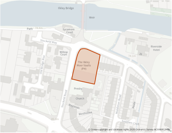
Site Size (ha) Gross: 0.23
Proposed Land Use: Housing
Minimum Development Capacity (Dwellings): 12
Site Type: Greenfield
Ward: Ilkley & Addingham
Settlement: Ilkley
Ownership: Private
Delivery Timescale: Long 2035+ (11+)
Site Specific Requirements:
- Development should provide at least 12 dwellings as part of a high-quality built environment in line with Policies ST4 and DS1, at a net density of 50 dph in line with Policy HO2. This should include affordable housing (in line with Policy HO4 and an appropriate mix of dwellings (in line with Policy HO3 and having due regard relevant housing needs evidence and the character of the area).
- Sensitive site design and layout should be in keeping with the landscape character of the area and should also reflect relevant policies within the made (adopted) Ilkley Neighbourhood Development Plan.
- It is likely that the layout, design and scale of dwellings within the site should take design cues from the nearby linear form of traditional terraced house developments and that this should also be reflected in the materials. Careful consideration of the landscape strategy including retention of the existing trees at the south of the site, parking and bin storage will be needed.
Site Access, Highways and Transport
- Access is available from Stockeld Road.
Flooding, Water and Drainage
- Based on the evidence presented in the Level 1 SFRA (2023) and Level 2 SFRA, it is recommended that the risk area in the north of the site is left as open greenspace. A site-specific FRA will be required and must further consider the safe access and escape routes via Stockeld Road.
Natural and Historic Environment
- The site lies within Zone B (Supporting Habitat/Functionally Linked Land) - Development proposals must assess potential impacts on foraging habitat used by SPA qualifying species and provide ecological evidence where required, in accordance with the South Pennine Moors SPD and Policy NE3.
- The site is located within a bat alert area. An ecological survey will be required as part of any planning application to establish the extent/impacts as well as to identify appropriate mitigation.
- The site is adjacent to an area of TPO woodland and wholly within a bat alert area. An ecological survey will be required as part of any planning application to establish the extent/impacts as well as to identify appropriate mitigation.
- An appropriate condition regarding pre-development below ground archaeological assessment/study is likely to be required. Notwithstanding this, development of the site will need to be informed by and respond to the surrounding high quality development within the conservation area and be respectful of the setting of the scheduled bridge. The existing stone boundary wall along the Stockeld Road and Bridge Lane frontages should also be incorporated to ensure that this important element of the rural character of the site is retained.
Environmental Protection
- Site is partially within a Mineral Safeguarding Area (MSA) for Sand and Gravels. A mineral resource assessment will be required as part of any planning application to determine the extent and availability of any Sand and Gravels resource.
Open Space and Green / Blue Infrastructure
- The Open Space Assessment identifies a need to secure the provision of Amenity Greenspace within new developments, particularly where such provision can connect with existing open spaces and contribute to the wider Green Infrastructure network. The Assessment also highlights deficiencies in the provision of allotments, children's play areas, open land in settlements and parks and gardens within the settlement, which should be taken into account when considering opportunities for new open space provision. Open space should be provided in line with Policy NE2, having regards to the standards set out in Appendix 11.
- Site is partially within an area of high provision and high need for green and blue infrastructure. Development proposals should focus on carefully designed green and blue infrastructure to contribute towards site specific issues e.g. flood mitigation, urban cooling, etc.
Landscape
- The site is located within the Wharfedale Settled Valley Floor Landscape Character area/type (G4). No landscape sensitivity assessment was undertaken for this site. Consideration should be given to the guidance set out in the Landscape Character Assessment SPD.
Infrastructure Requirements
- Proportionate contributions to community infrastructure will be required, where appropriate, in line with Policies ID1 and ID2, and having regard to the Local Infrastructure Plan.
H1547: Land north of Skipton Road (Hadfield Farm), Ilkley Comment
Site Boundary:
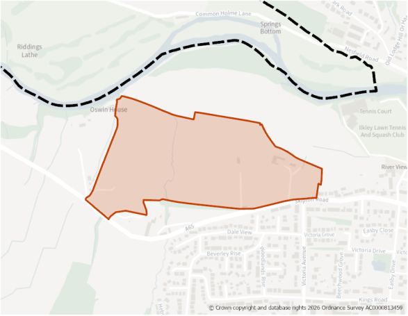
Site Size (ha) Gross: 20.86
Proposed Land Use: Housing
Minimum Development Capacity (Dwellings): 256
Site Type: Greenfield
Ward: Ilkley & Addingham
Settlement: Ilkley
Ownership: Private
Delivery Timescale: Medium 2030-2035 (6-10)
Site Specific Requirements:
- Development should provide at least 256 dwellings as part of a high-quality built environment in line with Policies ST4 and DS1, at a net density of 35 dph in line with Policy HO2. This should include affordable housing (in line with Policy HO4 and an appropriate mix of dwellings (in line with Policy HO3 and having due regard relevant housing needs evidence and the character of the area).
- The design and layout should also reflect relevant policies within the made (adopted) Ilkley Neighbourhood Development Plan.
Site Access, Highways and Transport
- Three site access points are recommended and a Stage 1 Road Safety Audit of all site access junctions should be provided with any application.
Flooding, Water and Drainage
- Based on the evidence presented in the Level 1 SFRA (2023) and Level 2 SFRA it is recommended that the north of the site is converted to open space and used as a multifunctional greenspace for flood storage, amenity use and to provide environmental / ecological benefits, given the fluvial risk to the site in the 1% AEP plus climate change event and also the modelled impact of climate change on the functional floodplain.
- A site-specific FRA will be required and should undertake new hydraulic modelling of the ordinary watercourses. This modelling should include for blockage scenarios to account for residual risk to the site. Safe access and escape routes during the present day and climate change events must be considered further as part of the site-specific FRA.
- No development should take place over the top of a culvert nor within 8m either side of the culverted section of watercourse. Assuming there are culverted watercourses within the site, opportunities for opening up the culverts should be explored for inclusion in site design as a blue green corridor. This would remove any residual risk of flooding to the site as a result of culvert failure or blockage.
- A detailed drainage strategy will be required. Surface water should be retained onsite where possible. Runoff volumes should not exceed current greenfield rates.
Natural and Historic Environment
- The site lies within Zone B (Supporting Habitat/Functionally Linked Land) - Development proposals must assess potential impacts on foraging habitat used by SPA qualifying species and provide ecological evidence where required, in accordance with the South Pennine Moors SPD and Policy NE3.
- The site is located within a bat alert area. An ecological survey will be required as part of any planning application to establish the extent/impacts as well as to identify appropriate mitigation.
- The site is partially covered with TPO woodland and contains areas of washland, woodland and grassland habitat. The site is also within a bat alert area. An ecological survey will be required as part of any planning application to establish the extent/impacts as well as to identify appropriate mitigation.
- In terms of heritage, the impact of developing the areas of the site which are located in close proximity to Hollin Hall farmhouse and outbuilding, will be difficult to mitigate and it is considered likely to result less than substantial harm (of an unacceptable level).
- Development may be acceptable on other areas of the site with appropriate measures and mitigation to protect the setting of the nearby listed buildings and with appropriate conditions to protect any below ground archaeology that may existing within the site.
- The site is identified in the LNRS with the preferred measures: T2_M04: Extend and connect tree and woodland cover across the White Rose Forest area in West Yorkshire, G1_M03: Restore and enhance existing species-rich grasslands, and G3_M03: Buffer and link existing neutral grasslands.
Environmental Protection
- Site is partially within a Mineral Safeguarding Area (MSA) for Sand and Gravels. A mineral resource assessment will be required as part of any planning application to determine the extent and availability of any Sand and Gravels resource.
Open Space and Green / Blue Infrastructure
- Site is partially within an area of low provision and medium need for green and blue infrastructure. Development proposals should focus on carefully designed green and blue infrastructure to contribute towards site specific issues e.g. flood mitigation, urban cooling etc.
- The Open Space Assessment identifies a need to secure the provision of Amenity Greenspace within new developments, particularly where such provision can connect with existing open spaces and contribute to the wider Green Infrastructure network. The Assessment also highlights deficiencies in the provision of allotments, children's play areas, open land in settlements and parks and gardens within the settlement, which should be taken into account when considering opportunities for new open space provision. Open space should be provided in line with Policy NE2, having regards to the standards set out in Appendix 11.
Landscape
- The site is located within the Wharfedale Settled Valley Floor Landscape Character area/type (G4).
- Development should be located in the east and west of the site behind existing development, where new development would be screened in wider views. Avoid development in the centre of the site, where development is more prominent in views from the settlement edge and rising slopes to then north and south. Minimise development in views from the Ilkley Conservation Area.
- Traditional drystone walls and hedgerows should be retained and integrated into new development. Trees and tree belts should be included to help integrate the development into the landscape (particularly along the river), and any existing vegetation protected and enhanced.
Green Belt (and Golden Rules)
- Site has been removed from the Green Belt. Development on the site should be consistent with the “Golden Rules” set out in the NPPF in relation to affordable housing, necessary improvements to infrastructure and accessible green space provision.
Infrastructure Requirements
- Proportionate contributions to community infrastructure will be required, where appropriate, in line with Policies ID1 and ID2, and having regard to the Local Infrastructure Plan.
POLICY ME1 – MENSTON: Comment
Settlement Plan:
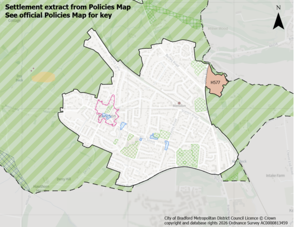
Settlement Hierarchy and Spatial Directions
- The village boundary is defined on the Policies Map and consists of the main body of settlement which lies to the southern edge of the Wharfe valley, between Rombald’s Moor/Burley Moor to the west and the boundary with the Leeds City Council area to the east and south. To the south of Menston is a residential area in the Leeds District, formed from the conversion of the former High Royd’s hospital site. Maintain the importance of the landscape in separating the settlement from Burley in Wharfedale, Guiseley and Otley and preventing coalescence
- The focus for sustainable development of this large village reflects its sustainable location with good highway links and public transport connections including a railway station and regular bus services to nearby communities, as well as the range of services and facilities it provides. This is balanced against the importance of its historic centre with designated heritage assets and wider environmental and physical constraints.
- The settlement features significant environment constraints which focuses growth within its linear settlement form and boundary.
Meeting Growth Needs:
- Housing development includes a combination of development within the settlement boundary and land to be released from the Green Belt during the plan period and will:
- Deliver approximately 188 dwellings through a combination of sites under construction, planning permissions and new site allocations as set out in Table ME1.1
- Deliver housing site allocations as shown on the Policies Map and section 5:
- H577: Otley Road
Table M1.1:
|
Under Construction |
Planning Permission |
Site Allocations |
|
|
Totals |
117 |
6 |
65 |
- Proposals for new homes within the settlement boundary on additional small sites, including the redevelopment of previously developed land, will be supported subject to meeting relevant policies.
Local Services and Facilities
- Support the vitality and viability the designated Menston Local Centre as shown on the Policies Map as a key hub for the community to meet their day-to-day shopping needs as well as the retention and enhancement of local services and facilities.
- Protect and enhanced designated open spaces in compliance with Policy NE2 and support proposals which address deficiencies in open space provision as set out on the Open Spaces Study including increased provision in the north of settlement and increase provision of Allotments, Outdoor Sports, and Parks and Gardens. Improve the quality of and access to local sites such as Menston park.
- Maintain and enhance sport and recreation facilities whilst widening community access and physical improvements to enhance participation rates will be supported.
Landscape
- Enhance the landscape setting with its Wharfedale Rolling Upland Pasture landscape character area, landscape features, fields and overall settlement pattern. Reference should be made to the Landscape Character Assessment Supplementary Planning Document.
- Proposals should minimise the influence of development in views to and from Nidderdale National Landscape.
Historic and Natural Environment
- Protect and enhance green and blue networks and corridors and address deficiencies in provision to enhance biodiversity and recreation within and adjacent to the settlement as well as incorporating sufficient green space and connections within new developments.
- Protect and enhance the designated South Pennine Moors Site of Special Scientific Interest (SSSI), to the west of the settlement and the Burley Disused Railway Local Wildlife Site as well as habitat networks and priority habitats within and adjacent to the settlement.
- The western section of the settlement is located within SPA/SAC Zone B (supporting habitat functionally linked land), whilst the eastern section is within SPA/SAC Zone C (7km) (recreational pressure). Development proposals must assess potential impacts on foraging habitat used by SPA qualifying species and provide ecological evidence where required, as well as mitigate any recreational pressure on the SPA/SAC caused by such development in accordance with the South Pennine Moors SPD and Policy NE3.
- Development should conserve and key heritage assets and their settings within and adjacent to the settlement, in line with Policy HE1.This includes Menston Conservation Area, archaeological site, Scheduled Monuments, High Royds Hospital Listed Park and Garden and Listed Buildings including Fairfax Hall and other local heritage assets.
Local Infrastructure
- Supporting safe active travel routes (cycling and walking) through the settlement, to services and facilities including connecting new development.
- Support and safeguard the route of the Wharfedale Greenway for cycling, walking and horse riding in line with Policies ST2 and TR1.
- Support improvements and access to public transport and active travel, including enhanced links to Menston railway station and measures to reduce traffic congestion on routes
- Proportionate contributions to new or enhanced community infrastructure will be required, where appropriate, in line with Policies ID1 and ID2, and having regard to the Local Infrastructure Plan.
Menston: Site Allocations
H577: Otley Road, Menston Comment
Site Boundary :
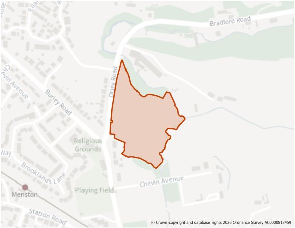
Site Size (ha) Gross: 3.41
Proposed Land Use: Housing
Minimum Development Capacity (Dwellings): 65
Site Type: Greenfield
Ward: Wharfedale
Settlement: Menston
Ownership: Private
Delivery Timescale: Short 2025-2030 (1-5)
Site Specific Requirements:
- Development should provide at least 65 dwellings as part of a high-quality built environment in line with Policies ST4 and DS1, at a net density of 50 dph in line with Policy HO2. This should include affordable housing (in line with Policy HO4 and an appropriate mix of dwellings (in line with Policy HO3 and having due regard relevant housing needs evidence and the character of the area).
- A sensitive design and layout will be required taking into consideration the site’s location on the edge of the settlement. This should include appropriate landscaping and seeking to avoid areas that are at risk of fluvial and surface water flooding.
Site Access, Highways and Transport
- A new access would join Otley Road.
- The site is crossed by a Public Right of Way (Footpath Ilkley 71 from east to west). This should be retained as part of any future development.
Flooding, Water and Drainage
- Part of the northern corners of the site and the eastern site boundary are located within the function floodplain (Flood Zone 3b) as well as Flood Zones 2 and 3. No development should take place within the existing area of functional floodplain and directed away from areas modelled to be at risk of fluvial and surface water flooding. A Flood Risk Assessment should be provided as part of any planning application. The site is more than 1ha in size. A Flood Risk and Drainage Assessment should be provided to identify any potential flood risk and appropriate measures for managing it.
Natural and Historic Environment
- The site lies within Zone C (Recreational Pressure) - Residential development resulting in a net increase in dwellings will be required to mitigate any recreational pressure on the SPA/SAC caused by such development in accordance with the South Pennine Moors SPD and Policy NE3.
- The site is located within a bat alert area. An ecological survey will be required as part of any planning application to establish the extent/impacts as well as to identify appropriate mitigation.
- The site boundary should take account of the woodland habitat network to the east and south and adjacent grassland habitat network to the eastern site boundary.
- Site contains TPO trees and an area of TPO woodland. There are also areas of TPO woodland within and adjacent to the northern and eastern boundaries. The design and layout of any development should ensure these trees are preserved and enhanced in line with Policy NE6. An arboriculture study should be provided as part of any planning application.
- The site is identified in the West Yorkshire Local Nature Recovery Strategy with the preferred measure Priority B4: Nature-friendly transport infrastructure, and measure B4_M02: Significantly boost biodiversity wherever possible where there are existing habitats alongside transport infrastructure.
- Majority of the site is Agricultural Land Classification 3b.
Open Space and Green / Blue Infrastructure
- Open space should be provided in line with Policy NE2, having regard to the standards set out in Appendix 11. The Open Space Assessment indicates that in Menston there is a need for increased provision of allotments, parks and gardens and outdoor sports.
- Green and blue infrastructure should be provided in line with Policy NE1.
Landscape
- The site is within the Wharfedale Rolling Enclosed Pasture Landscape Character area/type (F2). Consideration should be given to the guidance set out in the Landscape Character Assessment SPD.
- The site has a moderate landscape sensitivity. Hedgerows should be retained and integrated into new development where possible. Trees and tree belts should be included to help integrate the development into the landscape. Locate development within existing dispersed settlement at the southern site boundary, along Chevin Avenue.
Green Belt (and Golden Rules)
- Site has been removed from the Green Belt. Development on the site should be consistent with the “Golden Rules” set out in the NPPF in relation to affordable housing, necessary improvements to infrastructure and accessible green space provision.
Infrastructure Requirements
- Proportionate contributions to community infrastructure will be required, where appropriate, in line with Policies ID1 and ID2, and having regard to the Local Infrastructure Plan.
Planning Permission
- An outline planning application is currently pending on this site for 65 dwellings which may be determined before the Local Plan is adopted.
