

Bradford District Local Plan - Publication Draft (Regulation 19) (October 2026)
Section 4: Thematic Policies Comment
4.1 Introduction
4.1.1This section of the plan is concerned with a wide range of thematic policies which build upon the strategic priorities and policies set out in section three of the plan.
4.1.2The main purpose of many of the policies in this section of the plan is to provide a local policy context to assist with effectively determining planning applications.
4.1.3The key policy areas covered in this section of the plan follow the overall format of the plan and include detailed policies as set out under the following themes:
- Planning for Homes
- Planning for Prosperity
- Economy
- Retail & Town Centre
- Transport & Connectivity
- Planning for Places & Communities
- Design and Place-making
- Supporting Sustainable Communities
- Climate & Resources
- Natural Environment
- Historic Environment
- Minerals
- Waste
4.1.4The policies set out in this section should be read with the plan as a whole and in particular with section three (strategic policies) and where relevant the implementation, delivery and monitoring policies under section six.
Planning for Homes
POLICY HO1: HOUSING DELIVERY Comment
Facilitating Housing Delivery
- To facilitate housing delivery the Council will:
- Meet housing needs as set out in Policy SS2 and support a wide range of housing delivery through the housing allocations as identified on the Policies Map and Section 5 of the Plan.
- Designate a series of Broad Locations of Growth in the form of Regeneration Areas to bolster housing-led regeneration in the Regional City and Keighley.
- Link an acceleration in housing delivery with new transport infrastructure investment at scale.
- Seek to maintain a 5-year supply of deliverable housing sites.
- Proactively monitor development activity and housing market trends and continue to develop its housing delivery action plan.
- Support the diversification of the housing stock and development of new housing products including, larger urban family housing, Build to Rent and Co-living in accordance with Policy HO3 and its unique character and heritage assets.
- Support opportunities through Policies HO3 and HO5 and planning decisions for sites to come forward for community led housing and self-build and custom housing.
- Support the delivery of specialist housing and accommodation as part of Major Large and Major Strategic sized sites and across other development opportunities.
- Promote the Brownfield Register and support the use of Permissions in Principle and Local Development Orders where applicable, to help bring forward Minor and Major Medium sized sites.
- Support the development of windfall sites in accordance with the Settlement Policies set out in Section 5 of the Plan.
- Encourage Neighbourhood Development Plans (NDP) to allocate Minor and Major Medium sized sites which would support sustainable development and comply with relevant policies in the NDP and Local Plan.
Unlocking Barriers to Housing Delivery
- To unlock barriers to housing delivery the Council will work with developers, stakeholders and infrastructure providers to:
- Ensure the right type and level of infrastructure is delivered to support housing growth in accordance with Policies SC1-SC6 and ID1-ID2.
- Ensure the efficient and effective delivery of new infrastructure while minimising impacts on residential amenity.
- Further develop and deliver a clear pipeline of urban housing development across priority sites and Regeneration Areas.
- Develop measures to reduce the uncertainty, risks and costs of developing previously developed land and urban sites.
Increasing the Rates of Housing Delivery
- To increase the rates of housing delivery the Council will:
- Encourage developers to diversify their housing offer in accordance with Policy HO3 to support a differentiated mix of housing to meet local housing needs and with multiple sales outlets.
- Encourage early engagement with Registered Providers of Social Housing (RP) and twin-tracked implementation of affordable housing to meet immediate needs but also increase per annum construction completion rates.
- Work with developers to use sustainable Modern Methods of Construction (MMC) and modularised offsite construction where practical to increase the efficiency of onsite construction periods.
- Work with developers to effectively balance the delivery of early scheme infrastructure implementation against construction build out rates.
- Work flexibly with developers to address scheme implementation challenges and modifications.
Direct Delivery
- The Council will directly support housing delivery through its relationships plans and investment programmes, including:
- The disposal and redevelopment of its own surplus land and property.
- Creating the right supporting conditions for housing growth for place-making and development of liveable and resilient urban built environments.
Explanation
Housing Challenges and Opportunities
4.1.5It is essential that the Local Plan includes policies and proposals which will ensure that that the housing required is delivered but also that housing growth is carefully managed and co-coordinated with any necessary infrastructure provision.
4.1.6Key housing challenges and opportunities as identified through the Strategic Housing Market Assessment (SHMA) Update (2026) and outlined below in Box HO1.1.
Box HO1.1 – Key Housing Challenges and Opportunities
- Affordable housing -Address the net shortfall of 759 affordable dwellings per year through a robust policy, maximising social rent where possible and applying the recommended 70:30 rented/home ownership split.
- Place-based housing need reflect substantial differences between the seven sub-areas and 19 Parish/Town Council areas rather than applying district averages.
- Dwelling size and overcrowding -Deliver a balanced range of homes, including two and three-bedroom affordable housing and larger homes for households experiencing overcrowding and larger-family need.
- Older people and specialist housing - Increase the range of adaptations, bungalows, level-access homes, sheltered and retirement housing, Extra Care and residential care.
- Supported housing and move on - Use the Local Supported Housing Strategy to address supply, quality, supported-living need and move-on pathways for young people, care leavers and people with complex needs.
- Accessible and adaptable housing - Embed and apply uplifted M4(2) and M4(3) requirements for housing, subject to viability and site-specific considerations.
- Private rented sector - Strengthen intelligence, enforcement, landlord engagement, housing advice and homelessness prevention in response to affordability, condition and legislative reform.
- Infrastructure and regeneration - Align housing growth with transport, health, education, drainage and community infrastructure, while making effective use of brownfield land, empty homes and town-centre opportunities.
- Other identified needs –meet needs for Gypsy and Traveller needs and subject to monitoring of delivery and supply; continue to monitor self-build, custom-build and localised student housing demand.
Local Plan Allocations and Mix of Supply
4.1.7Allocating and facilitating a land supply portfolio that contains a rich variety of sites of different sizes, types and locations will support housing delivery through an increased range of housing products and number of outlets, rather than concentrated on a small number of sites. The Local Plan allocates 254 housing sites which range from 3 to 1011 units. Table HO1.1 below sets out the number of sites and yield outputs by size categories. From the analysis just over 90% of the allocations fall within the grouped size categories of Minor, Major Medium and Major, this equates to a total combined yield of 12,081 units or just over 63% of the total allocations. While there are only 20 sites with yields above 200 (amounting to about 8% of the total allocation numbers) these equate to a total plan yield of 6,959 units, or just over 36% of the total allocations.
Table HO1.1: Local Plan Housing Allocations by Size and Total Yield
|
Size Categories |
Number of Allocations |
% of Total Allocations |
Total Yield |
% of Total Allocations |
|
Minor (1-9) |
17 |
6.69% |
124 |
0.65% |
|
Major Medium (10-49) |
131 |
51.57% |
3407 |
17.89% |
|
Major (50-199) |
86 |
33.86% |
8550 |
44.91% |
|
Major Large (200-499) |
18 |
7.09% |
5445 |
28.60% |
|
Major Strategic (500+) |
2 |
0.79% |
1514 |
7.95% |
|
Totals |
254 |
100% |
19040 |
100% |
4.1.8The NPPF (paragraph 73) recognises that small and medium sized sites can make an important contribution to meeting the housing requirement of an area with Local Plans expected to identify at least 10% of housing requirements on sites no larger than one hectare. SME builders often build-out reasonably quickly and in addition add variety to housing design and stock types. Table HO1.2 below considers the allocation mix in terms of more specific size thresholds, which demonstrates that just over 54% of the allocations are less than one hectare with a yield of about 24% of the total allocation yield.
Table HO1.2: Site Allocations and Gross Areas
|
Site Size (Gross Ha) |
Number of Allocations |
% of Allocations |
Total Yield |
% of Overall Allocations |
|
0.19-1ha (inclusive) |
138 |
54.33% |
4612 |
24.22% |
|
1.01-2.5ha (inclusive) |
59 |
23.23% |
4666 |
24.51% |
|
2.51-5.00ha (inclusive) |
28 |
11.02% |
3557 |
18.68% |
|
5.01-10.00ha (inclusive) |
20 |
7.87% |
2911 |
15.29% |
|
10.01+ |
9 |
3.54% |
3294 |
17.30% |
|
254 |
100% |
19040 |
100% |
4.1.9Local small and medium sized house builders in Bradford have traditionally played a strong role in the delivery of housing and this is forecast to continue based upon the plan allocation options, windfall analysis and supporting housing policies.
4.1.10For a variety of reasons, including the legacy of how the existing built-up areas have grown and their relationship to remaining key areas of environmental constraint (most notably topography, landscape sensitivity, and flood risk), there are a lack of large and very large sites in the land supply. Although the District’s land portfolio is heavily weighted to small and medium sized sites there are nonetheless some larger sites which are important to supporting overall housing delivery and in achieving the individual settlement targets as set out in Policy SS2.
4.1.11It is important for the district to continue to support local businesses and smaller scale developments which provide a base level of local housing growth, but this alone will not it itself tackle under delivery and as set out in Policies SS1 and SS2 there is a need for an ambitious but balanced spatial strategy to address this issue.
Facilitating Housing Delivery
4.1.12The District’s regeneration challenges and opportunities are substantial in scale and require a coordinated approach to housing-led regeneration linked to the delivery of transport and other infrastructure to improve connectivity and investment options in many parts of the Regional City and Keighley. The Local Plan designates a series of Broad Locations of Growth in the form of Regeneration Areas (totally 6,000 units) linked to major areas of transformational physical change which are set out in the spatial strategy and specific settlement policies. The housing growth in these locations is additional to site allocations and expected to come forward from year 6 + in the Local Plan period and aligned to infrastructure investment including transport and flood risk management. Further detail is contained with the Bradford District Technical Housing Paper (2026).
4.1.13The District as a whole has historically underperformed against housing targets, including the Housing Delivery Test (HDT 2025 is at 56%) and the five-year supply of deliverable housing sites. The picture of actual delivery is varied across the District which has four main housing value zones and a history when sites are available of strong housing delivery performance in locations such as Wharfedale, South Pennine Towns and Villages, parts of Airedale and towards the outer edges of the Regional City. The Local Plan will build upon areas strengths and increase the range and type of housing sites in the District and includes measures to proactively monitor development activity and housing market trends and continue to develop its housing delivery action plan.
4.1.14Bradford District has generally a limited range of housing products and is dominated its industrial legacy in many parts, post war housing estates and various periods of general housing growth and infill developments. The quality of built environments in some parts of the District is poor and its level of empty homes is above national average. SHMA (2026) reporting indicates a significant need to be more reflective of local population requirements (including extended families) and diversification of its housing markets to reflect changing demands and a move overall towards an ageing population.
4.1.15There are measures which can be put in place to facilitate housing delivery within this context including:
- Development of new housing products including Built to Rent and Co-living.
- Community led housing and self-build and custom housing.
- Specialist housing and accommodation.
4.1.16A further focus can also be applied to using existing information and planning tools such as the Brownfield Register, Permissions in Principle and Local Development Orders together with a proactive approach to supporting windfall development and housing allocations within NDPs.
Unlocking Barriers to Housing Delivery
4.1.17The Council considers it vital to manage housing growth in a sustainable way and there may be occasions where sites may need a creative approach to delivery pending the implementation of essential infrastructure. A series of policies in the Plan (SC1-SC6 and ED1-ID2) focus upon the right type and level of infrastructure at the right time to support effective housing growth – which supports the delivery of new sustainable neighbourhoods and not just housing numbers.
4.1.18Unlocking a clear delivery pipeline of urban housing sites and linked regeneration activity which builds upon projects such as City Village is at the heart of spatial strategy (Policies SS1 / SS2) of the Plan. This will require continued joint working with stakeholders, funders, investors and strategic partners. The Cushman and Wakefield City Centre Housing Strategy (2026) sets out broad ambitions and opportunities, but detailed work needs to continue on reducing the uncertainty, risks and costs of developing previously developed land and urban sites through existing partnership projects (including with the West Yorkshire Combined Authority, Homes England and other parties involved in infrastructure investment).
Increasing the Rates of Housing Delivery
4.1.19Developers need to tap into a range of market demand to boost housing delivery – including the housing mix and variety to appeal to a broad customer base but also, the provision of affordable housing which is an additional source of demand compared to general market housing. The exact absorption rate of housing delivery is likely to be informed by the strength of local market demand.[1]
4.1.20There may also be different modern methods of construction available to housebuilders and developers designed to be efficient alternatives to traditional ‘brick and block’ construction and reduce down-time on site and seasonal variations in build out rates and tackle onsite skills shortages.
4.1.21The Council is supportive of working with developers to facilitate innovation and work proactively with housebuilders to overcome site challenges and practical onsite issues and ensure delivery rates are on track. It requires a broad partnership between the Council and developers to deliver housing and growth – each playing a critical role.
Direct Delivery
4.1.22The Council itself is a clear anchor institution alongside the University, colleges and NHS within the context of regeneration and can use its asset base to support its financial stability but also deliver wider community benefits including the sale and lease of land and property to meet general and specific housing needs according to best value considerations.
4.1.23Housing delivery clearly doesn’t exist in a spatial vacuum and requires a focus by the Council and partners on place-making in a comprehensive way and improving liveability. This is particularly an issue in emerging and new housing markets in urban areas to support investor confidence and underpin growth.
Links
|
Strategic Objectives |
|
|
Key Policy Links |
Local Plan Policies:
|
|
Evidence Base |
|
POLICY HO2: HOUSING DENSITY Comment
- To meet the objective of delivering housing growth in a sustainable way, developers will be expected to make the best and most efficient use of land. This will mean delivering dwellings at an appropriate density standard while taking account of the need for a well-designed layout which enhances the area and provides a safe and healthy living environment.
- Unless site specific considerations indicate otherwise all developments will be expected to achieve a minimum site density requirement of 35 dwellings per hectare (net) unless:
- The site lies within 800m of a well-connected rail station and has a connectivity score of less than 70, where a minimum density of 50 dwellings per hectare (net) will be expected or;
- The site lies within both 800m of a well-connected rail station and has a 70+ connectivity score then a minimum density of 75 dwellings per hectare (net) will be expected or;
- The site lies within the Regional City or a Principal Town and has a connectivity score of 80+ where a minimum density of 150 dwellings per hectare (net) will be expected or;
- Sites within Bradford City Centre may also be appropriate for higher densities of 300 dwellings per hectare (net) and above, subject to location, heritage, infrastructure and design quality considerations and tall buildings advice and guidance.
- In determining planning applications at densities lower than standard, consideration will be taken of the mix and type of housing being proposed, site viability, local character, site topography and the character of the surrounding area including landscape, trees and biodiversity.
- Higher development densities will also be supported where innovation in design is proposed which is consistent with design policies and other guidance.
Explanation
Density and Efficient Land Use
4.1.24A key component of sustainable housing growth is to ensure that land is used as efficiently as possible, in particular in locations well served by public transport. The policy background to the Council’s housing density policy is provided in the NPPF which recognises the importance of density targets where there is an anticipated or existing shortage of housing land.
4.1.25Bradford faces a significant challenge in the identification and delivery of a sufficient number of homes to meet a growing population. Land, whilst available to meet housing need, often lies in less sustainable locations or has environmental and physical challenges preventing it being suitable or capable of being brought forward.
4.1.26The scale of the housing requirement supports a need for a progressive density policy, which protects allocated land supply from inefficient layouts and schemes which provide only limited forms of development at low densities. The policy is supported by SS1.
Urban Regeneration and Transportation
4.1.27One of the key aims of this Local Plan is urban regeneration and promotion of sustainable development to minimise dependence on private cars and as part of this, has focussed the majority of new homes to be developed, into the Regional City and Principal Towns where a good level of local services already exist and access to strong public transport networks. The DfT Connectivity Tool[2] combines transport and land use data to generate a national measure of connectivity which can be used by Local Authorities in numerous ways including to determine appropriate development density expectations.
4.1.28The tool provides a connectivity score, which, alongside proximity to key transport nodes, the Council have used to determine the expected density expectations for sites in certain locations. The allocated housing sites indicate the minimum expected yield that should be delivered.
Empirical Evidence and Policy Links
4.1.29Evidence on residential development density in the CBMDC Technical Housing Report (2026) across the District in recent years has concluded that in the City Centre and the other parts of the Regional City and Principal Towns that higher development densities have consistently been achieved.
4.1.30The policy is required to ensure that all development proposals meet the minimum development density of 35dph (net) with those in the areas which are well served by public transport achieving higher levels of density. It has been drafted to provide sufficient flexibility for innovation and to recognise local character and is in line with the Local Plan’s focus on urban regeneration, efficient use of land and maximising housing delivery.
4.1.31The minimum density requirements should be balanced alongside the ‘Character Assessment’ as required by Policy DS3, to factor in consideration of local character, noting that this should not necessarily preclude increasing densities in well-connected locations where it is appropriate to do so.
4.1.32The policy should be read in conjunction with the Local Plan design policies (specifically including HO8, DS2, DS3, DS4, ST4 and TR3) and the Council’s residential design guide SPD ‘Homes and Neighbourhoods: A Guide to Designing in Bradford’, together with the Bradford City Centre Design Guide SPD and Historic England Advice Note 4.
4.1.33For the purposes of clarity, the targets set out within the policy relate to net site densities, which is determined by measuring the number of dwellings against the net expected developable site area. This means including only those parts which will be developed for housing and directly associated uses but excluding roads within the site, public open space and areas of landscaping. The expected minimum site yields identified in the site proformas have been calculated on these principles.
Links
|
Strategic Objectives |
|
|
Key Policy Links |
|
|
Evidence Base |
|
POLICY HO3: HOUSING MIX Comment
Housing type, size and tenure
- All proposals for general housing should provide a good mix of housing type, size and tenure, to address the needs of the District’s growing and diverse population, as well as supporting mixed and inclusive communities.
- The housing mix included in table 2 below based on the SHMA (2026) and any subsequent updates to this should form the initial basis for the type, size and tenure of development proposals. This will be flexibly applied according to:
- The site size, context, physical characteristic, including any identified constraints.
- The location and nature of the site and surrounding context. Higher proportions of flatted units are more appropriate on previously developed sites within locations that are within or proximity to town centres, railway stations or have good public transport access or connectivity.
- The extent to which proposals are addressing the District’s strategic priorities of increasing the provision of family sized (. i.e. three bedrooms or more) dwellings and affordable housing.
- The need to optimise housing output on previously developed land and support the delivery development within the regeneration priority areas.
- The need to deliver a range of tenures and the extent to which flexibility around the mix of market units could secure the delivery of additional affordable dwellings.
- Needs identified by the Council’s housing register.
- Any Neighbourhood Plan housing mix policies that are consistent with strategic housing priorities of the Plan and any up-to-date robust supporting evidence to inform these.
- Flatted developments will be required to give the highest priority to the provision of accommodation for families on the lower floors of the scheme, with direct access to a private garden or communal amenity space. These should be well designed to address the needs of family members who may be disabled or elderly or may have other mobility requirements.
Bungalows or level access dwellings
- Major developments should seek to include different sized bungalows/ dwellings with level access that prioritise delivery of two-bedroom units in short term; and three bed (or more) units in the long term; within the overall mix of schemes, to address the needs of an ageing population and those with disabilities. The provision of these will be particularly important in locations with good access to local facilities/services via sustainable modes of transport or good public transport connectivity; to support independent living, reduce loneliness and support sense of community.
Need for larger family sized housing for Black and Global Majority Groups (BGM) and other groups
- The Council will support proposals for larger family-sized housing (i.e. 4 bedrooms or more) to meet the needs of BGM groups and address issues such as overcrowding and needs of multi-generational households. Proposals for new larger dwellings and well-designed extension to the existing stock on suitable sites will be supported providing:
- an identified need is demonstrated;
- a good balanced mix of housing is delivered within a scheme or locality;
- it does not result in the over concentration of such size units;
- it does not impact viability of sites and undermine the Council’s ability to address local housing needs; and
- it does not adversely impact the character of an area and the amenities of neighbouring properties.
Build to rent developments
- Proposals for built to rent developments will be supported providing they meet the criteria below:
- It is located within Bradford City Centre and the regeneration areas that will be the key focus of such developments; or within other secondary locations that have good access to local facilities, services, including public transport.
- It supports mixed and inclusive communities.
Co-living developments
- Proposals for co-living developments will be supported, providing they meet the criteria below:
- It is located within Bradford City Centre and the regeneration areas that will be the key focus of such developments; or within other secondary locations that have good access to local facilities, services, including public transport.
- It provides high-quality private units which provide adequate functional living space and layout and are not self-contained homes or capable of being used as self-contained homes.
- It is well designed in terms of ensuring it has an adequately sized private living areas with a sufficient quantity and range of internal/external communal areas and facilities for the intended number of users.
- A satisfactory management is provided to demonstrate the development will be well maintained, managed and will not harm the amenities of neighbouring properties.
- It supports mixed and inclusive communities.
Explanation
Planning for Balanced Housing Growth
4.1.34A key objective of the Local Plan is to ensure that planned housing growth will deliver a mix and balance of housing, which meets the existing and future needs of the projected household growth and its diverse population. Mixed and inclusive communities require a variety of housing in terms of size, type, tenure and price to meet the needs of different households.
4.1.35The SHMA contains useful data in relation to the make-up of the District’s existing housing stock, broken down by type, tenure, size and their locations where different quantities of such accommodation exist. The current housing mix by dwelling type and size for the District is set out in Table HO3.1, based on 2025 Valuation Office Agency data.
Table HO3.1: Current dwelling type and size
|
Dwelling type and number of bedrooms |
Percentage |
|
Bungalow 1-bedroom |
1.0% |
|
Bungalow 2-bedrooms |
3.7% |
|
Bungalow 3-bedrooms |
1.9% |
|
Bungalow 4 or more -bedrooms |
0.2% |
|
Flat 1-bedroom |
9.2% |
|
Flat 2-bedrooms |
6.6% |
|
Flat 3-bedrooms |
0.5% |
|
Flat 4 or more-bedrooms |
0.3% |
|
Terraced house 1-bedroom |
2.0% |
|
Terraced house 2-bedrooms |
12.2% |
|
Terraced house 3-bedrooms |
18.3% |
|
Terraced house 4 or more-bedrooms |
4.9% |
|
Semi-detached house 1-bedroom |
0.0% |
|
Semi-detached house 2-bedroom |
4.3% |
|
Semi-detached house 3-bedroom |
22.6% |
|
Semi-detached house 4 or more-bedrooms |
2.6% |
|
Detached house 1-bedroom |
0.0% |
|
Detached house 2-bedrooms |
0.1% |
|
Detached house 3-bedroom |
3.5% |
|
Detached house 4 or more-bedroom |
6.3% |
|
Total |
100.0% |
4.1.36The above indicates that:
- 76.7% of dwellings are houses (37.3% terraced, 29.5% semi-detached and 9.9% detached), 16.5% are flats and 6.8% are bungalows;
- 12.2% of dwellings have one bedroom, 26.9% have two bedrooms, 46.7% have three bedrooms, and 14.3% have four bedrooms; and
- there are a lower proportion of larger sized flats, and a high proportion of house are family sized (i.e. three or more bedrooms).
4.1.37In relation to the tenure of the housing stock, the latest census indicates 61.3% is comprised of owner occupier, 23.1% private rented and 18.1% affordable housing. Further, it indicates 76.5% of dwellings have 3 or more bedrooms, and 66.5% of social rented dwellings and 56.0% of private rented dwellings have 1 or 2 bedrooms.
4.1.38The Strategic Market Assessment 2026 assessed the demographic changes and the impact of these for the future type, size, tenure of housing required in order to address the future housing needs for different types of households that are expected to form over the Plan period. The outcomes of this are set out in the Table HO3.2 below:
Table HO3.2: Overall annual dwelling type/size and tenure mix recommendations
|
Short term – 2026 -2031 |
|||||
|
Dwelling type/size |
Market |
Social/affordable rented |
Affordable home ownership |
Total |
Longer-term dwelling mix to 2043[3] |
|
2 Bedroom House |
15-20% |
30-35% |
10-15% |
15-20% |
20-25% |
|
3 Bedroom House |
25-30% |
15-20% |
40-45% |
25-30% |
30-35% |
|
4+ Bedroom House |
25-30% |
0-2% |
15-20% |
20-25% |
15-20% |
|
1 Bedroom flat |
2-5% |
10-15% |
0-2% |
2-5% |
10-15% |
|
2+ Bedroom flat |
2-5% |
10-15% |
5-10% |
5-10% |
5-10% |
|
1/2 Bedroom Bungalow/ level access |
10-15% |
20-25% |
10-15% |
15-20% |
5-10% |
|
3+ Bedroom Bungalow/ level access |
5-10% |
2-5% |
5-10% |
5-10% |
2-5% |
4.1.39The above illustrates the overall dwelling types, size and tenure required to address the future housing needs of the District, over the short and long-term time frames. The key potential implications of this for potential development proposals are:
- There is a significant need to increase the percentage of family sized (three bed or more) housing for both market and affordable housing tenures, including larger dwellings for the Black and Global Majority households.
- The level of family sized housing accounts for circa 45-55% of all future needs and would partly address overcrowing as detailed within Policy HO9.
- There is also a need over the first five years of the plan in particular to increase the percentage of small and medium sized bungalows/level access housing as part of the overall dwelling mix of schemes in order to address the needs of those with disabilities, an ageing population and enable the movement of households between larger sized and housing designed to address a specific need.
- There is limited level of total need for the provision of additional flats in the first five years of the plan, except for the social rented and affordable rented products that have a moderate level of need. The total need to deliver a higher percentage of flatted units is forecast to increase over the longer-term.
- In relation to the size of future units required, there is currently a sufficient provision of 1-bedroom units particularly for flats and a limited need for such units, except for within the social rented housing units that has a moderate level of need.
Housing Mix
4.1.40The housing mix figures are broken down in more detail in the Tables HO3.3 and HO3.4 below to set out the tenure and types of dwellings that is required to reflect the expected future demographic changes and address the District’s housing needs.
Table HO3.3. Overall dwelling type and tenure mix recommendations
|
Dwelling type |
Market |
Social/affordable rented |
Affordable home ownership |
Total |
Longer-term dwelling mix to 2043 |
|
House |
70-75% |
45-50% |
70-75% |
65-70% |
70-75% |
|
Flat |
5-10% |
20-25% |
5-10% |
5-10% |
15-20% |
|
Bungalow/level-access |
20-25% |
25-30% |
20-25% |
20-25% |
5-10% |
Table HO3.4. Overall dwelling size and tenure mix recommendations
|
Number of bedrooms |
Market |
Social/affordable rented |
Affordable home ownership |
Total |
Longer-term dwelling mix to 2043 |
|
1 |
2-5% |
35-40% |
2-5% |
5-10% |
15-20% |
|
2 |
30-35% |
35-40% |
25-30% |
30-35% |
25-30% |
|
3 |
35-40% |
20-25% |
50-55% |
35-40% |
30-35% |
|
4+ |
25-30% |
0-2% |
15-20% |
20-25% |
15-20% |
Policy Approach
4.1.41The Council will adopt a flexible approach to determine the optimum number of units that can be delivered, the appropriate type, size and tenure of units of proposals on site-by-site basis. This will be based on the consideration of a range of factors such as site size, context, physical characteristic, location and the need to optimise the housing output of sites, particularly on previously developed sites. Strategic priorities such as the need to increase the delivery of family and affordable housing, along with the need to support development within regeneration priority areas, will also be considered.
4.1.42It is recognised there may be instances where proposals may not be able to provide a mix of housing in line with the ranges included in the tables above due to site specific factors/constraints and there may be sites within locations, such as town centres and public transport corridors, that may be more suitable for high density flatted developments on previously developed sites. In such instances, applicants must provide robust evidence to demonstrate they are proposing an appropriate housing size, type and tenure mix in line with the need ranges identified by the SHMA and other considerations included within this policy. Applicants that produce site briefs and/or masterplans should provide more detailed information in relation to the appropriate housing mix.
4.1.43The Local Plan Viability Assessment has indicated there is broadly viability for a range of site typologies to meet the requirements of this policy, providing the need ranges and targets identified by the SHMA are applied flexibly on a site-by-site basis.
4.1.44The above approach ensures a balance is achieved between a competing set of factors such as; increasing the delivery of housing to fully address the future housing needs of the area (particularly for families and low-income households) by optimising the housing output of sites; as well as the need to consider location specific factors like site size, constraints, location, character of the area and viability. It should be noted that the SHMA evidence indicates that there is a low priority to flatted developments and smaller sized units, particularly 1 bed units.
4.1.45The SHMA indicates that circa 5.5% of all households live in overcrowded housing, particularly in the social rented and private rented sector, as well as a shortage of two and three-bedroom dwellings. Further, there is a higher proportion of private rented and social rented, as well as younger couples and families with children within urban area of Bradford City, that is expected to accommodate a significant level of housing growth on previous developed sites. To respond to these challenges and promote more mixed and inclusive communities across the District. Flatted schemes will be required to provide family accommodation on the lower floors, with access to private gardens or communal outdoor amenity space. These should be well designed for the use of family members who may be elderly or have a physical disability or other health issues. It will be important to ensure new flatted residential developments are well designed at the outset to meet the needs of a range of users, particularly families and children. For example, proposals must ensure a sufficient quality and quantity of amenity space is provided with natural surveillance and should explore inclusion of extra storage space for push chairs, bikes, etc. in suitable locations near accesses. In addition, proposals should consider the inclusion of an appropriate level of two-bedroom units within their scheme, which are capable of accommodating four-bed spaces, to ensure they are flexible to changing circumstances of households who may choose to have children and avoid overcrowding.
Bungalows and level access accommodation
4.1.46The SHMA anticipates the District will experience an ageing population during the plan period, which will increase the number of residents that will suffer illnesses and/or disabilities. In response to this, it recommends a certain proportion of bungalows or level access accommodation should be delivered, as part of the overall size mix of residential developments. A large proportion of the need for such accommodation is within 1 or 2-bedroom units and, to a lesser extent, 3-bedroom or more units. The benefit of this is it will allow the release of underoccupied accommodation and release family sized units for other households.
4.1.47In compliance with the tables above, major development proposals should demonstrate that they considered the inclusion of appropriate levels of bungalows and level access accommodation as part of the overall size mix within their scheme. This will be particularly important on sites that are within locations that have good access to local facilities, services and public transport or public transport connectivity. The key reasons are that it will enable those who are elderly or have disabilities to maintain independent lives, reduce loneliness and create sense a community.
Need for larger family sized housing for Black and Global Majority and other Groups
4.1.48The SHMA indicates that there is short term need to provide larger family sized housing (i.e. four-bedroom or more units) to address the needs of Black and Global Majority population who tend to live as multigeneration households, as well as overcrowding that can impact the health and well-being of residents. The SHMA includes detailed information in relation to these matters.
4.1.49The Council will support proposals for the delivery of larger sized housing. This is providing proposals demonstrate an identified need within the locality of the application site, the scheme includes a good balanced mix of housing on the site (or locality) that will not adversely impact housing delivery or the ability to meet other needs and there is no adverse impact on the amenities of neighbouring properties.
Build to Rent Developments
4.1.50Build to rent development provide purpose-built housing that provide rented accommodation that is under single ownership and professionally managed. It provides accommodation with long term tenancies. It can form part of a wider multi-tenure development comprising either flats or houses but should be on the same site and/or contiguous with the main development.
4.1.51The Council will support the delivery of build to rent developments, as they will help diversify the housing offer in the market and increase housing choice with long term tenancy. In addition, it will enhance the quality of the private rental stock and increase the stock of family and affordable housing. It is important development supports mixed and inclusive development.
4.1.52Bradford City Centre and the regeneration areas are considered the most appropriate locations for build to rent schemes, as the West Yorkshire Mass Transit scheme that is expected to be delivered during the plan period and make it a highly attractive location for significant investment and development. This scheme is expected to deliver a new station at Bradford City Centre, a new integrated tram and enhanced bus network connecting it to Leeds and wider areas. Other secondary locations that have good access to local facilities and services will also be considered for such proposals.
Co-living Developments
4.1.53Co-living development[4] is a purpose-built rental scheme, with non-self-contained single occupancy accommodation. It provides accommodation for young single person households and is often targeted at skilled professionals. It comprises of functional private living areas with extensive communal spaces and facilities, under single professional management. It includes a wide range of amenities to support a diverse community of residents and their needs. Developments have an emphasis on communal living, with large-scale shared dining, recreation and sometimes workspaces, as well as additional services and facilities such as an on-site gym and a concierge service. Such developments do not fall within a C3 land use class and is considered a sui generis use.
4.1.54The Local Plan supports the delivery of co-living developments, as they can help increase the stock of rooms, choice within the private rental sector and increase the supply of high-quality accommodation that can help free up the family sized housing stock that is used as HMO’s or shared accommodation, as well as provide more secure tenancies. They can also support the redevelopment of previously developed sites within the city centre, regeneration, the vitality and viability of town centres, as well as diversify sources of housing supply to address local needs.
4.1.55Bradford City Centre and regeneration areas are considered the most appropriate location for co-living developments. The City Centre contains a university, a railway station within it, as well as provides good access to local facilities, services, retail, leisure and public transport. It is expected to accommodate a high level of development during the Plan period, supported by significant levels of investment in the infrastructure, such as mass transit to improve connectivity within the District and wider areas. Other locations that have good access to local facilities and public transport will be considered for such developments on a case-by-case basis.
4.1.56Applicants must ensure the private rooms are of an adequate size to provide a satisfactory personal functional living space and environment for the health and well-being of residents. A sufficient level and type of communal space should be provided for the number of private units proposed within a co-living scheme, given the relatively small size of private space and potentially high number of residents using these. An adequate quantity of kitchen facilities, dining and lounge areas are an important component of shared living. These should be well designed, highly accessible and meet the needs of all users.
Links
|
Strategic Objectives |
|
|
Key Policy Links |
|
|
Evidence Base |
|
POLICY HO4 – AFFORDABLE HOUSING Comment
Affordable Housing Targets and Delivery
- The Council will work in partnership with a range of stakeholders, such as developers, Registered Providers of Social Housing, Government and local communities to support the delivery of a minimum of 13,842 (or 759 units per annum) of genuinely affordable housing units for those in need, from all sources of future housing supply over the plan period.
- Affordable housing contributions will be required on all major residential developments of 10 or more gross dwellings or sites of 0.5 ha including mixed use schemes and changes of use. Proposals on sites within the relevant housing value zones set out in Figure 1 of the supporting text, should provide affordable housing at the target levels detailed below in Table HO4.1.
Table HO4.1: Affordable Housing Targets
|
Site Type |
Greenfield (within settlement) |
Brownfield / Mixed (within settlement) |
Green Belt (All Types) |
|
Zone A |
Minimum of 40%. |
Minimum of 40%. |
If the residential development is on land in, or being released from the Green Belt in Zone A it should instead provide a minimum of 50% affordable housing on site. |
|
Zone B |
Minimum of 25%. |
Minimum of 25%. |
If the residential development is on land in, or being released from the Green Belt in Zone B it should provide a minimum of 40% affordable housing on site. |
|
Zone C |
Minimum of 15%. |
Minimum of 15%. |
If the residential development is on land in, or being released from the Green Belt in Zone C it should provide a minimum of 40% affordable housing on site. |
|
Zone D |
Minimum of 10%. |
Minimum of 10%. |
If the residential development is on land in, or being released from the Green Belt in Zone D it should provide a minimum of 40% affordable housing on site. |
- Proposals for older person accommodation should ensure a minimum 10% of all gross units within a scheme are genuinely affordable dwellings.
- The Council will support proposals for the re-use or redevelopment of vacant buildings and will reduce the affordable contributions due, by a proportional amount of the equivalent to the existing gross floor space on such sites, providing robust evidence is provided to demonstrate compliance with the national policy/guidance on the Vacant Building Credit. This credit will not apply to abandoned buildings, buildings made intentionally vacant and sites released from the Green Belt.
Tenure Mix
- As a general rule, major residential developments will be required to provide a tenure mix of 70% low-cost affordable housing for rent, with a 50:20 split between social rented and affordable rented products; and the remaining 30% intermediate housing, in compliance with the Strategic Housing Market Assessment Update (SHMA) 2026 and any subsequent updates.
- Applicants for planning permission will be required to demonstrate that they have prioritised the delivery of higher levels of social rented housing and any low-cost home ownership products are genuinely affordable based on the most up to date data of local incomes and housing costs.
- The Council will prioritise the delivery of social rented housing over other affordable housing products as this is considered the most genuinely affordable product and the most appropriate to address local needs. An appropriate tenure mix however on a scheme-by-scheme basis will be secured via considering the factors below:
- The need to prioritise the delivery of a higher proportion of social rented housing in the mix of affordable housing;
- Site specific characteristics and physical constraints;
- Evidence of consultation with Registered Providers;
- Evidence to demonstrate a different tenure mix will support viability and lead to a higher quantity of affordable housing and provide products that are genuinely affordable for a range of household incomes to address local needs, and
- Evidence to demonstrate that the proposed tenure mix will deliver mixed inclusive communities within the locality.
Housing Mix and Supporting Inclusive Communities
- Subject to policy clause 12, all new affordable housing should be provided onsite and must be of a high-quality design having regard to other Local Plan policies. The design of the units should be ‘tenure neutral’ in line with the National Design Guide, so that affordable units are indistinguishable from market units in terms of quality of design and materials, space standards, access, amenity and distributed throughout site. In mixed tenure developments all residents must have access to amenities and communal spaces including play spaces.
- Any affordable housing provided should remain at an affordable price in perpetuity for eligible households, secured via the use of planning conditions or obligations.
- Applicants will be required to demonstrate their proposal is delivering the maximum level of genuinely affordable housing on site. This will be assessed based on the factors below:
- The schemes contribution towards the District’s strategic affordable housing target.
- The need to encourage the most efficient use of the site and optimise the affordable housing output of the site.
- The proposed tenure mix of the site and the need to prioritise the delivery of social rented housing and affordable family sized housing.
- Compliance with the requirements of Policy HO3: dwelling mix - proposals should meet a whole range of housing needs, particularly for those on low incomes who require family sized housing.
Rural Exception Sites
- Within Rural Areas, outside defined settlement boundaries, planning permission for residential development not specifically permitted by other policies, will only be supported in exceptional circumstances where:
- The scheme meets a proven local need for affordable housing that cannot be accommodated in any other way.
- The scheme delivers 100% affordable housing units, unless robust evidence is provided to demonstrate exceptional circumstances that justify the inclusion of some market housing to make the scheme viable.
- The scheme is community led or can demonstrate significant support from the local community.
- The occupancy of the dwellings can be restricted to individuals accepted as requiring affordable housing in the locality.
- It would not undermine the purposes or cause significant harm to the Green Belt or countryside.
- It is immediately adjacent to the settlement or forms a small-scale natural extension to it.
- There are arrangements in place, through the use of planning conditions or obligations, to ensure that the affordable housing remains affordable ‘in perpetuity’ and that the allocation of such housing continues to be prioritised for those eligible households to meet local needs.
Viability Assessments
- In some circumstances, where affordable housing targets cannot be achieved or there is a requirement for a more flexible approach to affordable tenure types the applicant must provide robust, up to date and verifiable evidence that the proposal will not provide the target level of affordable housing. The cost of any independent review must be covered by the applicant. Review mechanisms will be included within s106 agreements in such instances.
- Developers are expected to engage at an early stage with Registered Providers and make reasonable efforts to explore the availability of grant funding to increase the delivery of affordable housing within their scheme and address any viability issues that may arise.
- To maximise affordable housing delivery and address economic uncertainties that may arise over the development cycle, the use of review mechanisms will be required, where appropriate and included within S106 agreements of residential proposals granted permission which did not meet affordable housing targets due to potential viability issues at the application stage. This will enable the re-assessment of the schemes viability for providing the target level of affordable housing, at a later stage of the development process.
Offsite Contributions
- To support mixed and inclusive communities, all affordable housing provision should be delivered onsite. Offsite provision or payment in lieu will only be considered acceptable in exceptional circumstances, if robust evidence is provided to demonstrate that:
- It is not practical or feasible to provide affordable housing on-site due to site development constraints or other factors, and where off-site provision is proposed:
- A higher level of affordable housing can be secured through provision on an alternative site.
- Off-site provision is necessary to better meet priority housing need, such as for affordable family housing;
- The provision will better support inclusive and mixed communities.
- It is not practical or feasible to provide affordable housing on-site due to site development constraints or other factors, and where off-site provision is proposed:
- The contribution charge will be index linked to the House Price Index, to increase in line with inflation, and should equate to the cost of the land and construction of the number of units that would be required on site.
- This policy should also be read in conjunction with Policy ID2.
Explanation
Context
4.1.57Since 2000 house prices and rents have significantly increased and exceeded the rate of any rise in local incomes within the District. This has resulted in major housing affordability issues for local residents, particularly those on low income and younger households. This has had an adverse impact on the health, economic and social well-being of local residents in terms of increased levels of; overcrowding housing and homelessness, commuting long distances for accessing work or poor access to local services (schools, healthcare), facilities (including open spaces), employment opportunities; as well as social isolation and loneliness.
4.1.58A key Council priority is to ensure everyone has a comfortable home which meets their needs and helps them lead fulfilling lives. The Council’s District Strategy and Housing Strategy includes an aim to increase the supply of homes which are of the right type, and quality and are in the right location to meet the needs and aspirations of the District’s diverse and growing population. This includes the provision of affordable housing and the creation of mixed, inclusive, sustainable neighbourhoods. The Council will work with developers and other partners, including the West Yorkshire Combined Authority and Government to increase the delivery of affordable housing of the right type, tenure and size to meet the identified needs over the plan period.
Affordable Housing Need
4.1.59In line with the NPPF, a Strategic Housing Market Assessment Update (SHMA 2026) has reviewed and analysed the level of existing and future households who are unable to afford to own or rent suitable market housing and assessed the quantity of affordable housing, by size and tenure that may be required to address needs over the Plan period. This indicates a need to deliver a minimum of 759 affordable housing units (net) per annum, which is the equivalent of 40% of all additional housing against Standard Method needs of 1872 housing units per annum.
4.1.60The SHMA and viability evidence indicates there are notable geographical
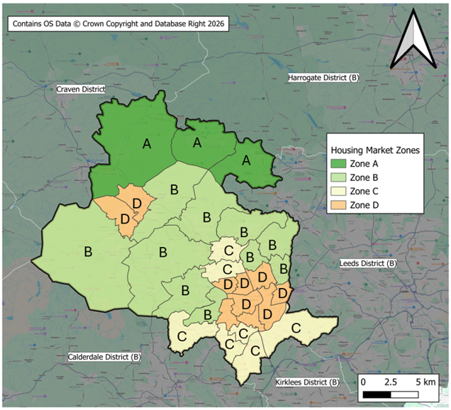
differences across the District in terms of affordable housing need, housing values and the economic viability of developing sites. The Bradford District Local Plan Viability Report (2026) recommends that the District is divided into four housing value zones to reflect these differences (see Figure 1 below). The zones are ward based.
4.1.61It shows that the northern wards of Airedale, Ilkley and Addingham and Wharfedale Wards fall within the highest value housing area (Zone A), with generally very good viability which can support a higher proportion of affordable housing, whereas the wards of the city centre and inner urban Bradford and Keighley (Keighley Central and Keighley West) fall within lowest value housing area (Zone D) and the viability to deliver affordable housing maybe challenging in relation to the current market conditions. Settlements within Zones B and C can accommodate various levels of affordable housing.
4.1.62The need for affordable housing in the lowest value area (Zone D) is relatively high, therefore it will be necessary to employ pro-active interventions to aid delivery in these areas and work with developers and partners to add value and overcome obstacles to the delivery of these lower value or marginal value sites. The Viability Study suggests a variable approach to the provision of affordable housing with different levels being required based on a series of viability assumptions and the strength of the local housing market. The policy therefore sets out the affordable housing requirements and thresholds for each of these zones.
4.1.63The Viability Study suggests a variable approach to the provision of affordable housing with different levels being required based on a series of viability assumptions and the strength of the local housing market. The policy therefore sets out variable affordable housing requirements and thresholds for each of these zones and according to whether importantly land is within a settlement (greenfield and brownfield / mixed) or on land in or being released from the Green Belt. As part of the ‘Golden Rules’ for Green Belt development as set of within the NPPF, paragraph 67 details that:
4.1.64a specific affordable housing requirement (or requirements) should be set for major development involving the provision of housing, either on land which is proposed to be released from the Green Belt or which may be permitted on land within the Green Belt. This requirement should:
- be set at a higher level than that which would otherwise apply to land which is not within or proposed to be released from the Green Belt; and
- require at least 50% of the housing to be affordable, unless this would make the development of these sites unviable (when tested in accordance with national planning practice guidance on viability).
4.1.65In reflection of national policy and viability study outputs in relation to Green Belt land this has informed the minimum Green Belt affordable housing targets set out in Table HO4.1
4.1.66While the Local Plan Viability Assessment considers a low percentage of affordable housing for Zone D locations will be challenging at present with a minimum target level of 10% noted – these areas are also subject to very significant regeneration activity and investment through the plan period.
4.1.67Values within Zone D locations are likely to change positively during the plan period and there will need to be a degree of flexibility with the type of affordable housing products secured within the early stage of the Local Plan through for example, intermediate or alternative hybrid market products to underpin scheme viability.
4.1.68The Local Plan Viability Assessment indicates it is generally viable to deliver affordable housing on site in line with the above zonal targets (Zones A-C), assuming a tenure split of 70:30 between low cost rented housing (50% of which are social rented housing) and the remainder comprising of genuinely affordable Intermediate affordable housing products such as low-cost home ownership. A 10% target is applied within Zone D recognising challenging values but also potential for value changes and flexibility in applying affordable housing tenure types, subject to viability analysis
4.1.69The viability assessment indicates that it is generally viable to deliver a minimum 10% affordable housing dwellings within older person accommodation developments, particularly within extra housing schemes.
Delivery of Affordable Housing
4.1.70The Council will prioritise the delivery of affordable housing during the Plan period. This will be achieved using a variety of measures including through the requirement of contributions from the development of market housing.
4.1.71However, it is acknowledged that other measures will also be required to deliver affordable housing, especially in areas of poor viability. These include:
- Utilising funding sources and existing partnerships with the West Yorkshire Combined Authority and Homes England
- Maximise opportunities offered through the use of council owned land and property.
- Bringing empty homes back into use.
- Working with Registered Providers - there may be cases where Registered Provider’s bring forward their own sites to deliver 100% affordable housing schemes.
4.1.72The Council will require developers to deliver affordable housing on site to support the delivery of mixed and inclusive sustainable communities. The affordable housing should be spread throughout the development and be indistinguishable from market housing. Developers should work with Registered Providers, where appropriate, to transfer the target amount of stock of an appropriate standard.
4.1.73Planning applications will need to be accompanied with an affordable housing statement, which sets out the level of affordable housing that will be delivered on a site as a percentage of:
- Total residential provision in habitable rooms
- Total residential units and habitable floorspace[5] that will be delivered within the site.
4.1.74The use of affordable housing figures as a percentage of habitable rooms, ensures that a range of sizes of affordable housing are delivered within the scheme, including family sized housing. Habitable rooms within the market and affordable elements should be of a comparable size when averaged across the development. If this is not the case it may be more appropriate to measure the provision of affordable housing by habitable floorspace.
4.1.75In a limited set of circumstances, it is recognised that off-site provision via commuted sums may be appropriate. Applicants will need to discuss this at the pre-application / planning application stage and will need to provide robust viability evidence, to demonstrate that affordable housing provision is in compliance with the above policy if it is not feasible or there is a need for a review of affordable housing tenures.
4.1.76A Vacant Building Credit may apply on certain sites that comply with the criteria in the NPPF to support the re-use of brownfield land, where vacant buildings are being reused or redeveloped. On such sites, any affordable housing contribution due will be reduced by a proportionate amount equivalent to the existing gross floorspace of the application buildings. This credit does not apply to vacant buildings which have been abandoned or made intentionally vacant.
Tenure Mix
4.1.77The SHMA (2026) recommends a tenure split of 70% low cost rented and 30% intermediate tenure (affordable home ownership) products, based on assessment of local needs and affordability. In relation to low cost rented housing, it recommends a split of 50:20 between social rented and low cost rented housing.
4.1.78In compliance with the SHMA, applicants will be required to deliver a high proportion of low cost rented housing within their proposed tenure mix, prioritising higher levels of social rented housing. The tenure mix will be considered on a site-by-site basis using evidence in the SHMA, viability assessments, individual site characteristics/constraints and local need and demand for affordable housing, as well as the need to maximise the delivery of genuine affordable housing. The tenure split set out in the policy will be used as a starting point for negotiations.
4.1.79The SHMA 2026 includes an analysis of the affordability of market housing and affordable tenures at the prevailing housing market prices at both neighbourhood and district levels, as well as the level of income that may be required to afford these. An analysis is included of the types of housing rental and ownership options which would be genuinely affordable to households based on actual local incomes and assumptions made around the proportion of income that should be spent on renting and buying.
4.1.80The Council will utilise the findings of the SHMA as a guide and use other relevant evidence to assess whether the affordable housing products applicants are proposing at different prices/rents genuinely represent appropriate affordable housing to households on different levels of incomes across areas within the District.
4.1.81Applicants for planning permission will be required to have regard to the SHMA and other latest evidence to demonstrate that the proposed affordable housing products are genuinely affordable to local residents, particularly for intermediate products, to address local housing needs.
4.1.82The Council may prioritise the allocation of low cost rented and intermediate affordable housing for certain key workers and veterans of the armed forces, based on the housing register and other evidence of need. This will be secured via a S106 agreement with developers on a site-by-site basis.
Viability
4.1.83In line with national policy, the affordable housing targets have been set based on local needs, national policy and viability. Viability evidence justifies setting different affordable housing targets across the District due to differences in values and site location and type (greenfield/brownfield/Green Belt status). Where an applicant for planning permission wishes to demonstrate that a site is financially unviable (to provide the amount of affordable housing at the level set in the policy) then, they must provide a suitably detailed Viability Assessment in support at the application stage, which will be independently assessed and the cost of this will be borne by the applicant.
4.1.84To maximise affordable housing delivery and address economic uncertainties that may arise over the lifetime of a development proposal the use of ‘review mechanisms’ will be required, where appropriate and included within S106 agreements of residential proposals granted permission which did not meet affordable housing targets due to potential viability issues at the application stage.
4.1.85Such proposals will be subject to an early-stage review, and a late-stage review triggered at the point that 75% of homes are occupied or at a point agreed by the Council. Larger phased schemes may also be subject to a mid-stage review. This will enable the Council to re-assess whether the viability of affordable has changed since permission was granted and if additional contributions are due from the applicant.
Rural Exception Sites
4.1.86The NPPF indicates that in rural areas, plans should support opportunities to bring forward rural exception sites that will provide affordable housing to meet identified local needs. Rural exception sites should be well related to the existing settlement to ensure they provide a sustainable location for development. The policy is clear that sites should be located physically adjacent to the existing settlement – meaning that they should be attached to the settlement boundary or form a natural extension to the settlement.
4.1.87The policy sets out the criteria used to assess the suitability of proposals for rural exception sites. Applications for rural exception sites should include an affordable housing statement which demonstrates the following:
- How the site(s) would address the needs of local communities by accommodating homes for current residents or for those who have an existing family or employment connection. Evidence of local need should be strongly justified, and it should also demonstrate that there is no alternative suitable housing within the relevant settlement, and that the selected site is viable to deliver affordable housing.
- Evidence of local need which could include the use of parish or settlement housing needs assessments. The Council will need to verify that the potential buyers/tenants of the properties meet the income or connection criteria.
- That the affordable housing to be provided is to remain affordable in perpetuity, and this should be secured through a planning condition or obligation where appropriate.
- That the type of affordable housing to be provided should be of the size and price of the housing required to meet the local need. In very exceptional circumstances, a proportion of market homes may be allowed on these sites where it is essential to enable the delivery of affordable housing without grant funding.
Links
|
Strategic Objectives |
|
|
Key Policy Links |
|
|
Evidence Base |
|
POLICY HO5: SELF-BUILD & CUSTOM-BUILD HOUSING Comment
Self and Custom-Build Housing Register
- The Council will continue to maintain an up-to-date register of individuals and associations seeking to acquire serviced plots in the District in order to build homes for those individuals to occupy.
- The Register will be used as part of the assessment of the need for Self-Build and Custom-Build Service plots within the Bradford District.
Supporting Self and Custom-Build Housing
- The Council will support planning applications of serviced plots for self and custom-build housing where proposals accord with other policies in this plan and with a particular focus upon:
- Minor sites, including collective self-build and proposals for co-living.
- Major medium sized, Major and Major Large sites where provision is evidenced by demand, site specific circumstances, viability and meets the design requirements of Policy DS1.
- Affordable housing sites of all sizes.
- The Council will support proposals from groups of individuals or organisations who wish to work together to develop self-build and custom-build housing on sites capable of accommodating two or more properties, where the proposals conform with other Local Plan policies.
- Initiatives that develop local and sustainable construction skills in the delivery of self-build housing will also be supported.
- Proposals will be supported for self-build and custom-build housing within Neighbourhood Development Plans where they accord with other policies in the relevant plan.
Planning Application Requirements
- Planning applications for serviced plots for self and custom-build housing must be accompanied by:
- the relevant Policy DS1 design requirements and evidence to demonstrate how the scheme meets the definition of self and custom-build; and
- evidence of local need including consideration of the Self and Custom Build Register.
- a self-build CIL exemptions form.
- The reversion of self-build or custom-build housing serviced plots to open market or affordable housing plots will be permitted if evidence is provided to the council that plots have been effectively marketed for sale and a buyer has not been found within a 12-month period. The plot must have been priced reflecting local market values.
Explanation
National Planning Policy
4.1.88Self-build and custom-build housing is a key element of the Government’s requirement to increase housing supply. National Government Policy promotes Self Build and Custom Build Housing as part of a wider range of housing supply options.
4.1.89The National Planning Policy Framework requires that the needs of people wishing to commission or build their own homes to be assessed and reflected in planning policies.
4.1.90Legislation has been introduced in the form of Self Build and Custom Housebuilding Act 2015, and subsequent amendments and Regulations.
4.1.91The Legislation and regulations require local authorities to maintain self-build and custom housing registers and have regard to these when carrying out planning, housing, land disposal and regeneration functions.
Local Context
4.1.92Self-build and custom-build housing can be an effective way to increase the mix of housing sizes, types and tenures and has the potential to increase the delivery of innovative and sustainable housing developments in a cost-effective manner. Self-build and custom-build housing developments will make a positive contribution to the supply of houses in the Bradford District.
4.1.93Bradford Council maintains a Self and Custom Build Housing Register for individuals and groups seeking to acquire land to build a home in the district. The latest published monitoring information reports 338 eligible registrations to the end of May 2026.
4.1.94TheStrategic Housing Market Assessment Report (2026) uses information from the Self and Custom Housing Register and indicates that the available evidence points to a growing but still relatively specialist demand for self-build and custom-build housing in Bradford, focused particularly on detached and larger homes and on higher-demand locations in Wharfedale and parts of Bingley and Shipley.
4.1.95The encouragement of self-build housing has the potential to bring small sites and windfall sites not previously considered as part of the Local Plan process forward for development which in turn will help meet the housing requirements of the District.
4.1.96Policy HO5 supports those seeking to build or commission their own homes and aims to help work towards self-build and custom-build housing becoming a more mainstream housing option in the Bradford District. It is also a potential avenue for people to deliver smaller homes and different types of affordable housing models and co-housing initiatives.
4.1.97The Council will support self-build and custom-build housing plots being made available to individuals or groups of individuals by developers on parts of larger residential development sites. Developers will be supported when promoting and offering serviced plots for purchase and development by individuals or groups of individuals wishing to build their own houses within larger residential development schemes. In these cases, individuals would play a part in the design and layout of the final properties. A serviced plot shall have access to a public highway and connections to relevant utilities such as electricity, water and drainage.
4.1.98Self-build projects are exempt from CIL[6]. A self-build exemption form must be completed and submitted with supporting evidence before the housing project starts, along with notifying Bradford Council’s Planning Service, and a further form submitted within six months of completing the project. If the evidence is not submitted to Bradford Council within six months, the full CIL charge becomes payable.
Links
|
Strategic Objectives |
|
|
Key Policy Links |
|
|
Evidence Base |
|
POLICY HO6: SUPPORTED AND SPECIALIST ACCOMODATION Comment
Supported and Specialist Accommodation
- The Council will work positively with its partners such as NHS, charities and developers to support the delivery additional well designed supported and specialist accommodation to address needs of vulnerable, disadvantaged individuals or groups of the population.
- During the Plan period, the Council will work with a range of stakeholders to deliver a minimum of:
- 5298 units (or 312 units per annum) of specialised older person accommodation within a C3 use between 2026-2043;
- a minimum of 1875 C2/C3 extra care units per annum (or 110 per annum) between 2026-43;
- 104 bed spaces of C2 residential care towards the end of the Plan period, as there is a current oversupply; and
- 2871 units of Dementia Friendly accommodation, to address the needs of those with such illnesses, particular the elderly population, as part of the overall mix of housing delivered over plan period.
- Proposals for the improvement, redevelopment and provision of new supported and specialist accommodation will be permitted providing:
- It is demonstrated the scheme would meet an identified need, including those within the Council’s housing and commissioning strategies, particularly to enable the intended user to live independently.
- It provides the necessary level of supervision, management and care/support for the intended occupants, which will be secured via a legal agreement.
- They are well designed with infrastructure to support residents with social, physical, mental and/or health care needs, including dementia and autism.
- It is within an accessible location with good access to public transport or within walking distance to a range of community facilities including shops, medical services and public open spaces or these are provided on-site.
- It does not result in the over concentration of such accommodation within a neighbourhood, and harmful impacts on the amenities of neighbouring properties and surrounding area.
- The use of the Local Supported Housing Strategy will be supported to address supply, quality, supported-living need and move-on pathways for young people, care leavers and people with complex needs.
- The Council will work with stakeholders and developers to increase the range of adaptations, bungalows, level-access homes, sheltered and retirement housing, Extra Care and residential care across the Plan period.
Specialist older persons accommodation within a C3 use class
- To ensure the design of specialist older person accommodation (including extra care housing schemes) is suitable for the intended users, proposals will be required to:
- Include appropriate facilities for care where required, including good quality staff and visitor accommodation and supporting facilities.
- Provide appropriate bathroom, kitchen and laundry facilities together with communal rooms.
- Ensure the layout of communal spaces is designed to encourage incidental meeting, interaction, to develop a sense of community.
- Include provisions for affordable housing, in compliance with Policy HO4: Affordable Housing.
- Ensure appropriate wheelchair accessibility is provided, including a higher proportion built to M4(3)(2) building regulations standards for specialist older person accommodation that seek to address the needs of those aged 65+. This will be determined on a site-by-site basis based on the need to optimise output, viability, site size and other constraints.
- Demonstrate how the type of units and their design will address the needs of people with dementia and / or other long-term health conditions.
- Ensure adequate access, parking and servicing access arrangements, with a safe drop off point within 50m of the main entrance. This must be appropriate for emergency vehicles.
- Ensure appropriate provision of suitable charging points for mobility scooters is included on-site.
Older person care homes within C2 use class
- To ensure the design of residential and nursing homes is suitable for the intended users; proposals will be required to ensure:
- There is an appropriate balance of private residential space and ancillary space associated with the care required.
- There is appropriate privacy of internal spaces in the building for relevant groups, namely residents and staff.
- Accommodation is provided in line with relevant design guidance and best practice standards.
- There is adequate access, parking and servicing access arrangements with a safe drop off within 50m of the main entrance. This must be appropriate for ambulance/minibus drop-off.
- There is provision of accessible communal outdoor space including a well-designed garden space for use by residents, staff and visitors which features a good level of amenity with regard to daylight and sunlight, noise, enclosure, overlooking, privacy and security.
- There are an adequate level and range of care facilities and support, communal areas/facilities (i.e. dining areas, lounging area, kitchen meal preparation) offered to address the individuals’ needs of residents on-site.
Changes of use and loss of facilities
- The Council will resist the loss of supported and specialist accommodation, unless proposals demonstrate:
- adequate replacement accommodation of the same quality and quantity will be provided for the particular group in a suitable location;
- the accommodation is no longer required for the particular group or other relevant groups in need of supported/specialised housing;
- the accommodation is not suitable for the care of the intended occupants (or other relevant occupants of supported/ specialised accommodation) in its current condition and format and/or is incapable of being maintained at an acceptable standard; and
- the current use/alternative use for supported/specialised housing groups is unviable on the site and has been satisfactorily marketed without any interest.
Explanation
Positive Planning and Delivery of Supporting and Specialist Accommodation
4.1.99The Council seeks to ensure everyone has access to a decent and secure home. Supported and specialist accommodation provide an essential place of residence for the most vulnerable and disadvantaged individuals or groups of society and can include a certain level of support or care to address individual needs. The overall objective of this type of accommodation is to enable individuals to live as independently as possible within the community, with an overall focus of promoting social inclusion.
4.1.100A key aim of the Local Plan is to deliver housing to meet identified needs across the District, including the provision of suitable accommodation for older people, looked-after children and groups with specialist needs. Specialist housing is designed so that occupants can access support when required, whilst promoting independent living.
4.1.101The provision of a wide range of supported and specialist accommodation is likely to be necessary during the Plan period, including permanent, longer-term and shorter-term accommodation that meets local needs. This could include accommodation for the elderly; looked-after children; veterans; refugees; people with addictions/drugs problems; people with disabilities and physical or mental health issues; people suffering from dementia; homeless persons; victims of domestic abuse; and reablement accommodation for people who are ready to be discharged from hospital.
4.1.102The Council will also work positively with a stakeholder such as specialist accommodation providers, developers, charities, health care providers to support the delivery of new, innovative emerging specialist and supported accommodation products (e.g. inter-generational housing) that address the local housing needs of a range of end users. This is provided a local identified need is demonstrated for such supported specialist accommodation, there is an adequate level of supervision, management and care/support for the intended occupants it is end users, it is well designed and it complies with other requirements of the above policy.
Meeting Different Needs
4.1.103The SHMA assessed the additional accommodation needs of different groups with disabilities; health, age and life experience related. Some of these additional needs may be addressed via mainstream housing, with appropriate adaptations, support and care (if necessary). The key findings of this are outlined below:
1) Learning disabilities and autism:
- The number of people with moderate to severe learning disability (all ages) is estimated to be 2,138 people in 2025. This is expected to increase to 2,291 people (or 7.2% change by 2043, and for the 65 year+ age group it is expected to increase by 22.6%. It is noted that people with learning disabilities account for 63% of people within supported housing.
2) Mental health needs:
- It is estimated there are circa 63,790 residents in 2025 aged 18-64 years with common mental health disorders and forecasted to increase by 5.7% (to 67,412) by 2043. It is noted that this group comprises of circa 31% of people (1,100) people within supported living accommodation. The Council identifies a need to expand transition services for young people moving into adult services.
Local Supported Housing Strategy
4.1.104In line with the Supported Housing (Regulatory Oversight) Act 2023, the Council will produce a Local Supported Housing Strategy. This will include an assessment of current supply, unmet need and likely future demand for supported housing. In addition, the Council’s Adult and Social Services team publish a Market Position Statement that sets out the current commissioning approach and market opportunities for providers, the current understanding of social care needs, forecasts and demand projections for a range of needs. This includes housing, Extra Care and Supported Living, as well as areas such as Older People, People with Dementia, Learning Disabilities and Autism, and Equipment Services.
Location of Supported and Specialist Accommodation
4.1.105Proposals for supported and specialist accommodation should be situated within locations that provide good access to public transport, local services and facilities (including open spaces) in order to support the vulnerable and disadvantaged with health issues to be independent, facilitate social interactions, and avoid isolation and loneliness.
4.1.106Proposals for supported and specialised accommodation should not result in a harmful over concentration of similar uses, to support mixed and inclusive communities. A satisfactory management will need to be submitted setting out the type, level and duration of management/support that will be provided for the intended user; the measures needed for the safety and security (if necessary) of the user, as well as preventing harmful impacts on neighbouring amenities.
4.1.107The Council will protect the existing stock of supporting and specialist accommodation where a need exists and it is suitable, unless a replacement is proposed of equivalent quantity, quality on the site/ or alternative site. To justify the loss of such accommodation, applicants must demonstrate it is no longer needed to address a need of a particular group, it is not fit for purpose and refurbishment is not an option to make it suitable, and it is unsuitable for other relevant types of supported and specialist accommodation needs.
Specialist Older Person Accommodation
4.1.108Bradford is expected to experience an ageing population with a significant growth in the older population during the Plan period. The SHMA 2026 indicates that the number of people aged 65 and over is expected to increase by 26.7% between 2025 to 2043. This will not necessarily result in a linear increase of the need to provide specialist older person accommodation with differing levels of care and support required. Furthermore, needs are likely to be driven by:
- Retrofitting/adapting the existing stock of housing and providing new high-quality housing built to adaptable and accessible housing standards.
- The common cultural practice for multigeneration households to reside and care for one another in a single dwelling, particularly Global and Black Majority groups that form a large proportion of the area’s population.
- A move away from the traditional model of providing care homes (with support staff) toward providing specialist older accommodation products with an appropriate level of support, such as extra care housing that encourage independent living.
4.1.109The Council will adopt a balanced approach for addressing the future housing needs of an elderly population, which include a combination of measures to support improvements to existing housing stock such as installing wheelchair access that enable people to reside independently within their existing dwellings. Local Plan policies will support an increase in the provision of new housing with level access or built as bungalows, as well as increase the provision of housing built to building regulation accessible and adaptable standards as part of the overall general housing provision (see Policy HO8). This will ensure new dwellings do not require expensive physical improvements as the needs of the occupants change as they age and they can remain within their existing accommodation for a longer period of time. In addition, it recognises that a proportion of the elderly population will require a specialist type of older person accommodation with differing level of care and support, as well as care homes with specialist care staff.
Types of Accommodation
4.1.110The SHMA includes information on the range of older person accommodation products that could be delivered to address local housing needs and the key distinctions between them. It clarifies a range of specialist older person accommodation within a C3 use class that can be provided. This can include age restricted market housing for those ages over 55, retirement living/sheltered housing for those aged 60+ and extra care housing.
4.1.111The benefits of specialist older person housing within a C3 use are they enable older people to live independently for longer, with positive health and wellbeing outcomes, whilst allowing access to care staff (if needed). It can result in savings for the NHS (i.e. reduce admissions and long stays) and adult social care, prevent/delay more costly moves into care homes; provide dementia-friendly accommodation; and free up under-occupied homes (often with gardens) to meet the needs for family sized housing.
4.1.112Within C2 use class specialist older person accommodation comprise residential care homes and nursing homes. These help address the accommodation needs of the elderly population (and increasingly very elderly population) who have serious health issues or needs that require specialist care or professional nursing staff. They provide non-self-contained accommodation consisting of a residential setting where a number of older people live, usually in single rooms, and have access to on-site care services and other communal facilities.
4.1.113The SHMA utilised the Housing LIN modelling to assess the future housing needs of the existing and future projected increase in the older population and the type of products that may be required. Headline findings from the modelling are summarised in Table 1.
Table HO6.1: LIN Modelling – Headline Findings
|
Data |
Implications |
|
312 units of (or total of 5298 over 17 years) units of specialised older person accommodation within a C3 use, comprising of 349 units per annum of leasehold sheltered units, 66 units per annum of Enhanced Sheltered housing with a 50:50 between rent and sale, less the existing annual over supply of 103 units per annum of conventional sheltered housing for rent. |
There is a high priority to increase the provision of self-contained C3 specialist older person accommodation, particularly leasehold sheltered housing, followed by enhanced sheltered housing. In addition, there is a current over supply in conventional sheltered housing for rent that is likely to persist throughout the Plan period. |
|
110 C2/C3 extra care units per annum (or total of 1875 units), comprising of 26 units per annum of extra care housing for rent and 85 units per annum for sale. |
There is a moderate priority for increasing the provision of extra care housing for sale and rent that there is under provision for. |
|
6 C2 residential care bed spaces per annum (or a total of 104 beds). |
There is currently an oversupply of C2 residential care bed spaces, and a limited need may arise over the long term towards the end the Plan period. These figures are generally in line with the Council’s Adult and Social Services Market position statement. |
4.1.114The Council will apply affordable housing policy to specialist older person accommodation products such as extra care housing that tend to be self-contained housing with an element of care/support and are generally considered to be a dwelling house. The Council will consider the use class of such proposal and whether they fall within a C3 use, on a case-by-case basis.
4.1.115The Council may require a higher proportion of the proposed specialised older units’ products within a C3 use that are primarily aimed at the 65+ age groups to be built to wheelchair accessible M4(3)(2)(b) building regulations standards. This is supported by the SHMA that indicates that the elderly population are more likely to experience physical illness, disabilities and mobility issues. Also, the District has a high level of households with at least one member with illness or disability (39.8%) and only 2.8% of households live in properties that have been adopted or purpose built for wheelchair access. The appropriate level will be determined on a site-by-site basis.
4.1.116To ensure high-quality accommodation is provided, the design of specialist residential accommodation for older people must demonstrate it has considered and addressed key design aspects. To ensure appropriate privacy for residents, elements of a building should be ranked on a scale of ascending privacy, with the most public spaces close to either main entrances or centrally located, and the private dwellings the farthest away from the main entrance.
4.1.117There should be separation between areas just for residents, staff and visitors with a distinction between shared spaces. Provision of communal spaces must be proportionate to the scale of the accommodation, optimising the accommodation for residents whilst maintaining the usability of the communal spaces. The design scheme of outdoor amenity areas should be sensory stimulating for their occupants and reflect established good practices (e.g. dementia friendly design), particularly for the elderly and those who are experiencing dementia and/or other health conditions.
4.1.118Suitable bathrooms, storage space for equipment and appropriate rooms for activities must be provided. Providing storage space is important for mobility scooters, hoists and other equipment. In particular, extra care should provide sufficient charging points for scooters.
4.1.119Developments must also make adequate provision for access, parking and servicing for vehicles, with drop-off points for taxis, mini-buses and ambulances located near the building’s principal entrance.
Accommodation for People with Dementia
4.1.120As the District experiences an ageing population, there is likely to be higher levels of dementia amongst the population, particularly amongst the 75+ and 85+ age groups. The SHMA estimate there is currently 6,170 people aged 65 and over with dementia and 136 people aged 30 to 64 that have early-stage dementia within the District. In contrast, the number of people aged 65+ with dementia is projected to increase by 42.7% and increase by 61.2% for the 85+ age group over the Plan period (2025-43).
4.1.121The increased rates of dementia will require existing and new homes to be designed to cater for the needs of those with such illness and be located in areas that enable independent living, access to local facilities, services (including open spaces) and social interaction, as well as specialist accommodation such as extra care housing with an element of care/support. The RTPI dementia practice advice note (2020) indicates this will not necessitate the need to increase the provision of residential and nursing care homes because dementia persons can suffer from early stage, mild or severe forms of the illness. Hence, different measures can be taken to support them to maintain independent living for longer, as well as provide accommodation options that can include C3 residential care, extra care housing or care home as a last resort.
4.1.122The SHMA identified a need to deliver a total of 2,871 dementia friendly accommodation, which could be delivered as part of a range of specialist older person accommodation units, supported accommodation and general housing products such as bungalows. Proposals will be required to demonstrate the design of schemes has considered the planning practice guidance, RTPI practice advice note (2020), West Yorkshire Combined Authority Dementia Ready Housing Design criteria and other good practices for accommodating the needs of those with dementia, including measures to support independent living.
Accommodation for Looked-after Children
4.1.123The Department for Education’s definition of a looked-after child is: ‘A child is looked after by a local authority if they are provided with accommodation for a continuous period of more than 24 hours (section 20 Children Act 1989) or are subject to a care order (defined in section 22(1) Children Act 1989)’.
4.1.124The Council produced the Bradford Children and Families Trust’s Sufficiency Strategy 2025–2028[7] to assess the future accommodation needs. This set out there were 1377 children in care as of March 2025 and the types of placements that have taken place to address their needs. The sufficiency evidence also highlights accommodation pressures for care leavers. The December 2024 sufficiency update reported that, at the end of September 2024, there were 606 care leavers aged 18 to 21 open to the Trust. It noted some care leavers remain in supported accommodation after turning 18 because of a lack of suitable tenancies, flexible support and preparation for independent living. The strategy therefore identifies the need for suitable move-on accommodation, supported accommodation and effective transition planning for young people moving towards adulthood.
4.1.125Applicants will be required to demonstrate that their proposal has had regard to the above strategy or any other relevant needs assessment, and it is meeting an identified need. Proposals should particularly seek to address the current need for move on accommodation for children or supported accommodation for 18–21-year-olds, to enable them to develop the confidence of living independently in the future.
4.1.126In addition, applicants are encouraged to have early discussions with the Council’s health and social care team and provide evidence that they support the identified need that the proposal is seeking to address. It is important for proposals to demonstrate that they will provide adequate facilities support staff/management and will be well designed and located to meet the requirements of the intended users. Further, the potential loss of such accommodation should be supported by robust evidence in compliance with the policy.
Veteran Needs
4.1.127At the 2021 Census, 12,391 Bradford residents aged 16 and over had previously served in the UK armed forces, comprising 9,412 who served in the regular forces, 2,461 in the reserve forces and 518 in both. This represents 2.9% of the District’s population aged 16 and over, below the Yorkshire and The Humber figure of 4.2% and the England figure of 3.8%. Bradford’s veteran population is therefore proportionally smaller than in most districts, reflecting the District’s younger age structure, but it remains a group of more than 12,000 people to whom the Council owes specific statutory duties.
4.1.128Veteran housing need sits at the two ends of the age spectrum. At one end, the veteran population is markedly older than the population as a whole. Nationally almost one third of veterans are aged 80 and over, against 5.1% of non-veterans, and 32.1% of veterans are disabled as defined by the Equality Act, against 19.6% of non-veterans. Most of that difference is explained by age: once age, sex and regional differences are taken into account the gap narrows to 32.1% against 30.0%. The practical implication is that the majority of veteran housing need in Bradford is older person and accessible housing need, and it will be met through the mainstream stock, adaptations and the specialist older person and Extra Care provision considered earlier in this chapter rather than through veteran specific accommodation.
4.1.129At the other end of the spectrum, a smaller number of veterans face homelessness or require supported housing on leaving service or following relationship breakdown. That need falls within the housing related support and single person supported accommodation. Op FORTITUDE, the national referral pathway for veteran homelessness, provides a route into supported housing which local partners are able to access.
4.1.130The Council’s obligations to this group are specific. Bradford Council and twenty partner organisations signed the Armed Forces Community Covenant in January 2012, and section 8 of the Armed Forces Act 2021 places a statutory duty on local authorities to have due regard to the Covenant principles when exercising relevant housing functions, including the allocation of social housing and disabled facilities grants. Members and former members of the regular forces with urgent housing needs are entitled to additional preference within the allocation scheme under section 166A(3) of the Housing Act 1996.
4.1.131Since 18 December 2024, all former members of the regular forces have been exempt from local connection and residency qualification requirements, the previous five-year limit having been removed by amendment to the Allocation of Housing (Qualification Criteria for Armed Forces) (England) Regulations 2012.
4.1.132There is a need for veteran status to be recorded consistently on the housing register and within homelessness assessments, so that the Council’s forthcoming Supported Housing Needs Assessment and Local Supported Housing Strategy are able to quantify need for this group more directly.
Links
|
Strategic Objectives |
|
|
Key Policy Links |
|
|
Evidence Base |
|
POLICY HO7 – GYPSY AND TRAVELLER AND TRAVELLING SHOWPERSONS ACCOMMODATION Comment
Meeting Gypsy and Traveller Accommodation Needs
- The permanent authorised sites of GT1 Esholt (19 pitches), GT2 Mary Street (28 pitches) and GT3 Square Street (3 pitches) are retained and allocated for Gypsy and Traveller sites as detailed on the Policies Map.
- Over the plan period a minimum 54 new pitches for Gypsies and Travellers will be provided in Bradford District, consisting of:
- A minimum of 25 net additional pitches for Gypsy and Travellers to meet five-year authorised pitch shortfall for the period 2026/27 to 2030/31.
- A minimum of 29 net additional pitches for Gypsy and Travellers to meet longer term authorised pitch shortfall for the period 2031/32 to 2042/43.
Regularisation and / or Intensification
- Proposals for the regularisation and / or intensification of the sites detailed below in Table HO7.1 will be permitted where they meet the criteria set out below under HO7 6 A-J.
Table HO7.1 – Sites Suitable for Regularisation and / or Intensification
|
Name |
Intensification / Regularisation |
Total pitches |
|
Napier Road, BD3 8DA |
Regularisation |
1 |
|
207 Huddersfield Road, BD12 0TQ |
Regularisation |
3 |
|
85A Westgate Hill Street BD4 0SL |
Regularisation |
2 |
|
Avenue Street, BD4 9QT |
Regularisation |
1 |
|
Land to the rear of Fagley Road, BD2 3 |
Regularisation / Intensification |
4-6 |
Meeting the Needs of Travelling Showpeople
- The permanent authorised site of TS1 Paley Road (36 plots) is retained and allocated for a Travelling Showpersons site and is identified on the Policies Map.
- Proposals for the regularisation of the sites detailed below in Table HO7.2 will be permitted where they meet the criteria set out below under HO7 7. A-J.
Table HO7.2 – Sites Suitable for Regularisation
|
Name |
Total plots |
|
195 Gain Lane, BD2 3LW |
3 |
|
197 Gain Lane, BD2 3LW |
3 |
Planning Applications for Sites
- Planning applications for Gypsy and Traveller sites will be assessed against the following criteria:
- The delivery of a suitable site access which would not be detrimental to highway safety for vehicles, cyclists and pedestrians together with any required mitigation measures.
- The extent that the site can be served by utilities or infrastructure.
- Whether the site is accessible to services and facilities, public transport and active travel routes.
- Impact on residential amenity, or existing buildings or uses, either by the design, close proximity, activities or operations on the site which would be detrimental to the surrounding area.
- Whether proposed sites are located on land that is deemed unsuitable for general housing, such as land that is contaminated or adjacent to bad neighbour uses.
- The extent that the site incorporates good design and landscaping standards, providing a suitable level of vehicle circulation, storage space, open and play space, landscaping and biodiversity measures, security and service and utilities infrastructure, which is compatible with wider place-design including conservation and heritage considerations.
- Whether the application avoids areas of fluvial and surface water flood risk, but where there is limited flood risk within the site, the site layout should be designed in a way that avoids the siting of caravans within Flood Zones 2 and 3.
- Whether proposals for day rooms are of a proportionate size and massing to their function as outbuildings serving caravans.
- Any permission granted for a Gypsy and Traveller development will be subject to a condition limiting occupation to Gypsies and Travellers, as appropriate.
- In line with national policy, Traveller sites (temporary or permanent) in the Green Belt are inappropriate development unless the exceptions set out in the NPPF apply.
Loss and Protection of Authorised Sites/Yards and Pitches/Plots
- Should an authorised site or yard be temporarily or permanently closed due to environmental factors, regeneration or major project activity a collaborative process with residents should be undertaken to identify the provision of suitable alternative accommodation prior to displacement.
- The loss of authorised sites/pitches or yards/plots to alternative uses will be supported where:
- it can be fully demonstrated that the site no longer caters for current or future Gypsy and Traveller or Travelling Showpersons needs, or
- acceptable suitable replacement accommodation is provided, prior to the loss of the existing site/yard or pitches/plots to maintain Gypsy and Traveller and Travelling Showpersons accommodation needs.
Negotiated Stopping Policy
- Provision will be made to apply a negotiated stopping policy to accommodate encampments of up to 5 caravans, encampments of between 6 and 10 caravans and encampments of more than 10 caravans to reflect the varying sizes of encampments experienced across Bradford District.
- The negotiated stopping policy covers the use of identified vacant land for a specified temporary period; the services to be provided by the local authority and supporting stakeholders, including welfare and health checks and the provision of temporary utilities including water, waste disposal and sanitation.
Explanation
National Planning Policy
4.1.133The NPPF states in Paragraph 63 that ‘the size, type and tenure of housing needed for different groups in the community should be assessed and reflected in planning policy’. A footnote in the NPPF then states ‘Planning Policy for Traveller Sites sets out how travellers’ housing needs should be assessed for those covered by the definition in Annex 1 of that document’.
4.1.134The Planning Policy for Traveller Sites (PPTS) (December 2024) document states that ‘local planning authorities should make their own assessment of need for the purposes of planning’ and ‘ensure that their Local Plan includes fair, realistic and inclusive policies’ and ‘to increase the number of traveller sites in appropriate locations with planning permission, to address under provision and maintain an appropriate level of supply’.
4.1.135The PPTS which, read in conjunction with the NPPF, has the overarching aim of ensuring fair and equal treatment for travellers, in a way that facilitates the traditional and nomadic way of life of while respecting the interests of the settled community. The PPTS includes an expanded planning policy definition of Gypsies and Travellers under Annex 1 which now includes ‘and all other persons with a cultural tradition of nomadism or of living in a caravan’ following court judgements, which makes the definition more inclusive.
4.1.136For plan-making there is a need to ensure compliance with PPTS paragraph 10 in relation to supply of sites, understanding of the relationship between sites, pitches and plots and surroundings areas and protection of local amenity and environment.
4.1.137Local Plans also need to set plot targets for Travelling Showpeople and have regard to the needs that Travelling Showpeople have for mixed-use yards to allow residential accommodation and space for storage of equipment. In setting pitch and plot targets Local Planning Authorities should address the likely permanent and transit site accommodation needs of travellers in their area, working collaboratively with neighbouring local planning authorities (PPTS para 9).
Local Context
4.1.138The Bradford District has a long history of Gypsy and Traveller communities with their diverse traditions and cultures, which can be traced back to historic place names, economic activities and community and cultural events. There are particularly strong Gypsy and Traveller communities concentrated in parts of the District, including Bradford South-East (Holme Wood).
4.1.139The 2021 Census reported a population of 906 people who identified as ‘White: Gypsy or Irish Traveller’ or ‘Gypsy/Romany’ and 252 people identifying as ‘Roma’ living in Bradford District. The total number of households was estimated to be 290 based on the number of Household Reference People identified in the census of which an estimated 278 live in bricks and mortar accommodation.
Understanding Local Needs
4.1.140The Gypsy, Traveller and Travelling Showperson Accommodation Needs Assessment (GTAA) 2026 provides the latest available evidence to identify the accommodation needs of Gypsies and Travellers and Travelling Showpeople across the area. This detailed study includes a review of secondary data, stakeholder consultations and household surveys with residents in sites / yards and bricks and mortar accommodation. The need was assessed over a short-term period 2026/27 to 2030/31 and longer-term period 2031/32 to 2042/43.
4.1.141In the absence of further guidance on preparing GTAAs, the methods adopted in the study reflect the PPTS, build upon those methods established through previous guidance, and practical experience and decisions made at planning inquiries and appeals.
4.1.142The GTAA focuses upon the needs of Gypsies, Travellers and Travelling Showpeople, with Roma community housing issues considered as part of Strategic Housing Market Assessment (SHMA) (2026) and specialist housing policy HO6. The GTAA evidence work has not identified specific accommodation needs from other nomadic groups such as New Age Travellers or other nomadic groups in Bradford District.
Gypsy and Traveller Pitch Requirements
4.1.143The GTAA identifies a total need of 73 pitches for the five period 2026/27 to 2030/31 following an assessment of households living on pitches; existing households planning to move in the next five years and emerging households (5 years), plus the housing register. This is balanced against a supply of 45 pitches on Council owned sites at Esholt and Mary Street and a small private permanent authorised site at Square Street (3 pitches), which in total equate to 48 authorised pitches with an additional two authorised pitches considered long-term vacant (Esholt). The five-year authorised pitch shortfall for 2026/27 to 2030/31 is 25 pitches.
4.1.144The study assumes that occupancy of the site at Mary Street will continue over the plan period or until such time that a suitable and agreed decampment strategy is finalised for alternative long term reprovision.
4.1.145The standard approach to modelling longer-term need is to use known household structure information from the household survey of households who have stated a preference for living on a pitch. On the basis of the age of children in households, it is possible to determine the extent of ‘likely emergence’, which assumes that a child is likely to form a new household at the age of 18.
4.1.146When calculating longer-term need, a reasonable assumption is that half of these children will form new households, bearing in mind culturally women tend to move away on marriage and men tend to stay in close proximity to their families on marriage. The model therefore assumes that 50% of children will form households when they reach 18 and that these households remain in the local authority area. This approach has been tested at inquiry, and the assumption has been corroborated by several Travelling interviewees.
4.1.147Analysis indicates an overall need for 29 additional pitches over the longer-term 2031/32 to 2042/43 based on the number of children living on sites and children in households wanting to move from bricks and mortar houses to pitches. Table HO7.3 below sets out the total short term and longer-term need shortfall.
Table HO7.3: Gypsy and Traveller pitch need 2026/27 to 2042/43
|
Period |
Pitch need |
|
5yr Authorised Pitch Shortfall (2026/27 to 2030/31) (A) |
25 |
|
Longer-term need |
|
|
Over period 2031/32 to 2035/36 (B) |
11 |
|
Over period 2036/37 to 2040/41(C) |
10 |
|
Over period 2041/42 to 2042/43(D) |
8 |
|
Longer-term need TOTAL to 2031/32 to 2042/43 (12 years) E=(B+C+D) |
29 |
|
NET SHORTFALL 2026/27 to 2042/43 (A+E) (17years) |
54 |
Travelling Showperson Plot Requirements
4.1.148There is one long-standing authorised Travelling Showperson’s yard in Bradford District and a further two unauthorised yards. There is sufficient capacity at the Showperson’s yard at Paley Road with 36 plots for Showpeople for the existing households using the yard and space for more households to use it. There is however a national strategic shortfall of Travelling Showperson yards and need may arise in Bradford District over the plan period.
Transit Provision
4.1.149The GTAA study also considered evidence of unauthorised encampment activity and views of specialist stakeholders to inform conclusions on transit need across Bradford District. Following feedback, good practice has generally moved away from identifying specific transit sites to positively managed negotiated stopping with local authorities making an agreement with Gypsies and Travellers on unauthorised encampments.
4.1.150The extent of managed negotiated stops can vary but is generally focused upon a common agreement with Gypsies and Travellers to use a vacant or unused piece of land as a temporary stopping place. Terms of the stop can include land and services to be provided by the local authority, including water, waste disposal and sanitation and the period of time for the negotiated stop.
4.1.151Based upon unauthorised encampment activity, the Council and supporting stakeholders will need to accommodate encampments of up to 5 caravans, encampments of between 6 and 10 caravans and encampments of more than 10 caravans to reflect the varying sizes of encampments experienced across Bradford District.
Meeting Need
4.1.152The location of new Gypsy and Traveller sites need to be sustainably located near services and facilities and provide for high-quality living environments in line with general housing. There may also be other specific locational site design requirements in terms of site access, business operations, vehicle circulation and storage together with environmental considerations in terms of noise and environmental screening that are of heightened importance on Gypsy and Traveller sites. The same type of criteria also applies to the regularisation of sites.
Links
|
Strategic Objectives |
|
|
Key Policy Links |
|
|
Evidence Base |
|
POLICY HO8 – HOUSING DESIGN STANDARDS Comment
The detailed design of homes, private outdoor spaces/gardens, and the ‘transition zone’ (the area between the building and the street) should fulfil the criteria below:
CREATING A SUCCESSFUL TRANSITION ZONE – FROM STREET TO FRONT DOOR
- ENTRANCES
- Front doors and building entrances to homes should be visible with a clear line of sight from the street/public areas and be clearly identifiable as entrances;
- Ground floor flats should have their front door accessible from the street.
- CIRCULATION SPACE FOR FLATS
- Communal circulation within flats including the entrance lobby should provide the space to enable some form of amenity to be provided for residents;
- Providing circulation via covered outdoor decks is encouraged to create a healthier and more convivial environment, and to enable dual aspect flats refer to J below.
- SETBACKS, FRONT GARDENS & PRIVACY
- Homes with habitable rooms on the ground floor frontage should have a minimum 1metre setback between the building and the back of pavement;
- Windows for ground floor street facing habitable rooms should start at least 1metre off the ground to protect the privacy of residents;
- Front gardens should consist of at least 25% soft landscaping to contribute to green streets and support biodiversity.
- BOUNDARIES
- Front gardens facing onto public areas should be demarcated by a boundary feature up to 1metre high (on average) consisting of one of the following treatments, depending upon context:
- Low stone or brick wall;
- Hedgerow;
- Railings;
- A combination of the above;
- Other suitable treatment as evidenced by the Character Assessment - see Policy DS3.
- Front gardens facing onto public areas should be demarcated by a boundary feature up to 1metre high (on average) consisting of one of the following treatments, depending upon context:
- BIN STORAGE
- Homes should be provided with individual or shared bin store shelters with adequate space for all bin types – see Appendix 12;
- Bin store shelters should be designed to be convenient and secure and to complement the character of the building and streetscape;
- A smooth and level access where practical should be provided between storage and collection locations;
- Where located externally bin stores should include green roofs.
MAKING GOOD BUILDINGS AND HOMES
- ENERGY EFFICIENT HOMES
- The Council will encourage and support new residential developments which achieve high sustainable design and construction standards, and high energy efficiency standards. The minimum acceptable sustainable housing standards are set out in the Building Regulations, refer also to Policies ST3 and CR3.
- ACCESSIBLE HOMES
- Proposals should provide a proportion of new homes which are designed to be accessible and adaptable to support the changing needs of families and individuals over their lifetime, particularly those of older people, people with young children and people with disabilities. To achieve this:
- New build residential developments should include the following proportions of accessible homes:
- On major development sites over 0.5 hectare or 10 or more homes a minimum of 5% of dwellings should meet the Building Regulations requirement M4(3) ‘wheelchair user dwellings’, designed to be wheelchair accessible, or easily adaptable for residents who are wheelchair users. The remaining 95% should be built to M4(2) accessible and adaptable standards;
- On minor developments of 9 dwellings or less, all homes should be built to M4(2) accessible and adaptable standards.
- Wheelchair accessible dwellings should also have access to outdoor space, parking and communal facilities;
- Where it can be robustly justified that site-specific factors, such as flood risk, site topography or viability make a site unsuitable or unviable to provide either M4(2) and/or M4(3) standard properties, the proportion of accessible homes required by this policy will be applied flexibly;
- The mix of sizes, types and tenures of accessible housing should align with the mix of sizes, types and tenures of the whole development, unless there is evidenced need for additional accessible housing of a particular tenure;
- The required number and mix of accessible homes should be clearly illustrated on submitted plans and will be controlled via a planning condition.
- Proposals should provide a proportion of new homes which are designed to be accessible and adaptable to support the changing needs of families and individuals over their lifetime, particularly those of older people, people with young children and people with disabilities. To achieve this:
- INTERNAL SPACE
- All new homes should provide a suitable amount of space appropriate to the type of home. To achieve this:
- All new market and affordable homes should seek to meet the Nationally Described Space Standard (NDSS) for internal space in new dwellings;
- Applicants should provide a schedule setting out the internal floor areas for each type of home;
- Justification should be provided where a home cannot meet the standards;
- Proposals for change of use, student accommodation and houses in multiple occupation will not be subject to the NDSS. Proposals should however, reflect the NDSS with appropriate adjustments made for these types of development and support quality design. They should also meet standards of general amenity for occupiers, including adequate space, light and ventilation.
- INTERNAL LAYOUT
- New homes should be well laid out internally, and are encouraged to be designed to provide the following features which can be met within the Nationally Described Space Standard (NDSS):
- Living areas that allow space for indoor play by providing:
- a minimum 14m2 for a 2 Person home (+ 1.5m2 per additional 1Person)
- a minimum width of 3m for a 2 Person home (or 3.5m for 3 Person+)
- Built-in floor-to-ceiling storage on each floor, a minimum 0.8 metre wide;
- A designated entrance zone inside front doors for storing everyday outdoor items by providing either a storage cupboard or an additional minimum 0.3 metre to the clear entrance width;
- A second separate living area and bathroom or shower room for 6 Person+ homes.
- The use of mediating space between habitable rooms to improve acoustic privacy and allow different activities including work and study to occur peacefully throughout the home.
- ASPECT
- Single aspect homes should be minimised. In circumstances where achieving dual-aspect homes is impractical then they should:
- avoid being north facing;
- be 1 or 2 bedrooms only;
- have a minimum floor to ceiling height of 2.5 metre, and
- where the Council is concerned about the quality of single aspect homes applicants will be required to provide evidence to demonstrate they will receive adequate natural light and ventilation.
ACCESS TO PRIVATE AND SEMI-PRIVATE OUTDOOR SPACE
- PRIVATE OUTDOOR SPACE
- Private open space should be directly accessible from at least all 2 Person + homes and be designed to allow for sitting out and privacy and to enable opportunities for planting, nature, rainwater harvesting, food growing and storage by providing the following:
- For houses and ground floor flats:
- A minimum 20m2 for 2 Person (+ 5m2 per extra 1 Person);
- A hard landscaped area of minimum depth 1.5 metre to allow sitting out
- At least 60% soft landscaping;
- A water butt (for watering plants and gardens).
- For flats:
- Provide a minimum 5m2 for 2 Person (+ 1m2 per extra 1 Person), with a minimum depth of 1.5 metre.
- Where the above is not practical good quality communal outdoor space should be provided - see L below.
- SEMI-PRIVATE COMMUNAL OUTDOOR SPACE FOR FLATS
- Major development proposals for new build flats and minor application proposals where practical should provide communal amenity space to include the following:
- Formal and informal seating opportunities;
- Doorstep play features;
- At least 33% of the space to be soft landscaping;
- Good access to direct sunlight - where the Council is concerned that a space may not achieve this, developers will be required to provide evidence that it complies with a nationally recognised benchmark such as BR 209;
- A sheltered area, from both sun and rain, of a minimum 6m2.
- Proposals for the conversion of existing buildings should seek to achieve the above criteria wherever practical. In cases where well-designed and innovative solutions don’t fully meet the above this may be acceptable.
- Major development proposals for new build flats and minor application proposals where practical should provide communal amenity space to include the following:
Explanation
Transition Zone
4.1.153The area between the street and the front door, plays a big role in the quality and attractiveness of residential environments and in providing a welcoming entrance and sense of arrival to the home. Careful consideration of set-backs from the street, front gardens and boundaries is needed to clearly distinguish between public and private and to provide residential amenity and some privacy, as well as reflecting local character and creating a sense of place. The policy sets some standards to help ensure these elements are successful and should be considered alongside the ‘Character Assessment’ (see Policy DS3).
4.1.154Also important, is the storage of bins in ways that are convenient for residents and the collection of waste, but which also support the overall quality of the transition zone to ensure bins don’t dominate or detract from the overall feel, appearance and walkability of a street. The policy is supported by Appendix 12 which sets out Bradford Council’s standards for household waste storage.
Energy Efficient Homes
4.1.155National planning policy requires any local requirements for the sustainability of buildings to reflect the Government’s policy for national technical standards. Through the Future Homes Standard, the Government aims to improve the energy performance of new homes, requiring all homes to be highly energy efficient, to incorporate low carbon heating, and be zero carbon ready. The standard expects new homes to produce 75-80% lower carbon emissions compared to current levels. Developments are encouraged to go beyond these minimum standards, Homes and Neighbourhoods: a guide to designing in Bradford provides further guidance and applicants should also refer to Policy ST3 (Climate resilience, Sustainability and Resource Use) and CR3 (Renewable and Low Carbon Energy).
Accessible Homes
4.1.156Bradford has an ageing population and levels of disability across the District are increasing. There are specific local issues with regards to overcrowding and the need for larger family housing, the quality, age and adaptability of the current housing stock and public health issues. This justifies the setting of optional technical standards exceeding the minimum standards required by Building Regulations. 5% of new dwellings on major schemes are to be built to M4(3) wheelchair accessible and adaptable standards with the remaining new dwellings being built to M4(2) accessible and adaptable standards. Part M of the Building Regulations sets a distinction between wheelchair accessible and wheelchair adaptable dwellings. In most cases it is expected that market housing provided through planning requirements will be wheelchair adaptable and should also be suitable for families with young children and pushchairs.
4.1.157The standards are currently set at a level to meet anticipated need and are flexible to respond to individual site circumstances. This will ensure that site specific factors such as vulnerability to flooding, the topography of the site or other circumstances which may make a site less suitable for accessible dwellings will be taken into account, particularly where step free access cannot be achieved or is not viable. In some instances, sites may clearly not be suitable for people with mobility issues. Applications for such sites would need to provide a clear justification as to the reasons the standards cannot be met.
Internal Space & Layout
4.1.158A common perception of new homes in Bradford is that they are too small and do not provide adequate areas for storage. To make homes fit-for-purpose, internal layouts should be of good, adequate size and planned out well so homes are functional, adaptable, and can meet our everyday needs, e.g. for play, home working, cooking, drying laundry, and relaxing alone or as a household. Built-in internal storage is also important for a well-functioning home, particularly for small homes, large families, and as a feature of autistic-friendly design.
Aspect
4.1.159Dual-aspect dwellings provide the opportunity for better access to natural light and ventilation which is vital for designing healthy homes that are resilient to a changing climate. Where dual-aspect homes are impractical or undesirable to achieve, the policy sets standards to ensure liveability. For flats, access galleries (or outdoor ‘decks’) can facilitate dual-aspect and are strongly encouraged as an alternative to internal corridors, and they can also create more sociable environments (in support of criterion 2).
Private Outdoor Space
4.1.160Private outdoor space allows residents to maintain a connection to nature, as well as a safe space for children to play close by. Family-sized homes would therefore be best accommodated in houses or ground-floor flats where private outdoor space is likely to be more generous.
4.1.161The policy includes standards for the size and design of private outdoor spaces for different types of homes. Where developments are not able to accommodate this, it should be clearly justified and generous semi-private communal space should be provided.
Semi-private Communal Space
4.1.162Communal outdoor amenity space provides a convenient location for residents to play, socialise and to access larger areas of open space nearby. It helps to nurture communities and make neighbourhoods safer and more inclusive. The policy specifies some key factors to be addressed when designing such spaces.
Linked policies
4.1.163This policy deals with the detailed design of new homes and private/semi-private spaces. Proposals for residential development should also have reference to other relevant policies in the plan, specifically with regard to design:
- Policy TR3 Parking – includes residential parking design standards
- Policy DS1 Design Process
- Policy DS2 Well-designed spaces and landscapes – including requirements for on-site play.
- Policy DS3 Urban Character & Form – including the requirement for ‘Character Assessment’.
- Policy DS4 Street Design – including standards for Green and Blue Streets and Inclusive Streets.
- Policy ST4 – Creating well-designed and healthy places.
4.1.164The Council will publish visual guidance alongside the plan to aid the implementation and assessment of this and other policies in relation to housing design.
Links
|
Strategic Objectives |
|
|
Key Policy Links |
|
|
Evidence Base |
|
POLICY HO9: EMPTY HOMES AND OVERCROWDING Comment
- The Council will work with stakeholders and use its plans, programmes and strategies to make best use of and improve the quality of the existing housing stock.
- Support housing delivery programmes and projects to help bring empty homes back into use through area-based approaches to urban regeneration and a coordinated approach to improving housing stock through work on housing standards, retrofits and adaptations, empty homes, health and regeneration projects.
- Deliver a balanced range of homes, including two and three-bedroom affordable housing and larger homes for households experiencing overcrowding and larger-family need.
- Policy interventions and investment priorities will be set out within the Council’s Housing Strategy, the Council’s Empty Homes Action Plan, and its key area and regeneration strategies.
Explanation
Tackling Empty Homes
4.1.165As at October 2025, the District had around 7,550 vacant homes or 3.4% of all stock, compared with the national rate of about 2.8% (SHMA 2026). The extent of long-term vacant homes was 3,415 or 1.5% of all stock. It is a key Council priority to address empty homes through the Bradford Housing Strategy (2020-2030) and the linked Empty Homes Action Plan (2025-2030). A summary of the action plan is detailed below in Box HO9.1.
Box HO9.1: Empty Homes Action Plan Priorities
- Enhance the outreach to empty property owners
- Continuous service improvement
- Data driven targeting – prioritise interventions
- Support neighbourhood regeneration – tackle empty homes in a way that contributes to revitalizing communities.
- Improve health outcomes - ensure properties brought back into use meet minimum health and safety standards
- Enhancing housing access and choice - improve housing availability and affordability by bringing empty homes back into use
- Maintain accurate records - ensure the data, both our own and that provided by partners, is reliable
- Deliver sustainable solutions - focusing on long term financially viable solutions for tackling empty homes
4.1.166Tackling empty homes in the District plays and important and central role in the regeneration of neighbourhoods, not only directly providing much needed homes but also improving the appearance of neighbourhoods and changing the narrative for communities, with regard to new investment and addressing deep-seated challenges in physical renewal. Bringing empty homes back into use is important as part of the wider housing delivery strategy and particularly in locations where the Local Plan is allocating new housing allocations as part of a co-ordinated strategy.
Overcrowded Housing – key challenges and directions
4.1.167One of Bradford’s most pressing housing challenges is overcrowding. It is well documented that overcrowding is not just a housing issue – it directly contributes to poor health and poor educational attainment and seriously damages quality of life for the families and households affected.
4.1.168According to the 2021 census 5.5% of households were found to be living in overcrowded conditions (insufficient bedrooms) which was most pronounced in the social rented sector. Whilst this figure is higher than both the regional (2.9%) and national averages (4.3%) it is considerably lower than in 2011. Half of overcrowded households are owner occupiers (50.1%), followed by private renters (28.6%) and social renters (21.3%).
4.1.169The Council’s Housing Strategy (2020-30) indicates that there were approximately 15,000 homes which are subject to overcrowding, with concentrations in a number of urban neighbourhoods including Great Horton, Manningham and Barkerend. Part of the key objectives in the housing strategy is to deliver more family housing and increase the supply of larger homes in areas with high levels of overcrowding.
4.1.170At its most basic level, rising rates of overcrowding are a symptom of the lack of availability and choice of more suitable housing. Therefore, the key measures through which overcrowding will be successfully tackled is through the increase in the right housing supply and by making better use of existing stock. This includes bringing empty homes back into use and reducing under occupation, which is also a priority.
4.1.171The areas in the District with the highest concentrations of low-income households are also associated with the poorest quality housing stock, overcrowding and empty properties and the resultant effects of poor health and poor quality of life in general. The key ways in which overcrowding will be successfully tackled is through the increase in housing supply, together with making better use of existing stock.
4.1.172Policy HO9 should also be read in conjunction with polices HO3 to HO6 which focus upon diversifying the District’s housing stock, to respond to improving the type and range of housing reflective of the District’s diversity and complex housing needs.
Links
|
Strategic Objectives |
|
|
Key Policy Links |
|
|
Evidence Base |
|
POLICY HO10: HOUSES IN MULTIPLE OCCUPATION Comment
- Proposals for the conversion/change of use a building or a dwelling house into Houses in Multiple Occupation (HMO) and hostels with shared facilities within a sui generis use will only be permitted where:
- It would not result in the loss of family-sized dwelling of three or more bedrooms, unless robust evidence is provided to demonstrate it is no longer suitable in terms of its design, layout, size for families and there is a lack of market demand.
- It is located within or accessible to the City Centre, Town Centres and District Centres, through public transport and active travel.
- It would support mixed and balanced communities and not result in the overconcentration of such uses within a neighbourhood. For HMOs, an over concentration is defined as an instance where three or more of the nearest properties are HMOs.
- There should be no harmful impact on the amenity of occupiers of neighbouring properties and the character of the area.
- Proposals for HMOs should demonstrate a high-quality design, to enhance the health, wellbeing of its occupants and surrounding properties. Proposal will need to comply with the requirements below:
- The accommodation should provide rooms of an adequate size for their purpose as set out in the Council’s Amenity Standards for Houses in Multiple Occupation, and subsequent changes to this and Policy HO8 with a satisfactory functional living spaces and layout.
- It must provide satisfactory level of parking provision in accordance with standards for the area.
- It should ensure a balance of hard and soft landscaping on the forecourt to enhance the appearance of the property and street scene, with regard to Policy HO8.
- It should provide an adequate level and type of ancillary facilities such as kitchen areas, WC’s, storage space and communal areas for lounging, dining is provided to address the daily needs for the proposed number of occupants.
- Adequate arrangements should be made for the storage and collection of waste and recycling material generated by future occupiers of the development.
- It would ensure all habitable rooms have a satisfactory living environment, in terms of privacy, daylight, sunlight, outlook and exposure to external noise.
- Adequate arrangements are made for the provision of amenity space for future occupiers in terms of access to gardens, communal facilities and areas.
- A Plan must be submitted in relation to the satisfactory maintenance, management of the HMO and measures to minimise potential harmful amenity impacts.
- The Council will also apply the above criteria to any proposals for the redevelopment of sites/premises or new construction to provide additional HMO accommodation.
Explanation
Low-Cost Accommodation and Types of HMOs
4.1.173The Council recognises the important role Houses in Multiple Occupation (HMOs) play for providing essential low-cost accommodation often for younger, low income sharing households, who don’t require self-contained accommodation.
4.1.174HMOs can provide a valued source of low-cost accommodation in the stock of housing providing they are of high-quality design and provide good quality living standards and adequate space for people to live in. They are particularly important in addressing the housing needs of: (a) Young and transient groups of the population, who have not reached a stage where they can or want to buy; (b) Vulnerable people and those on lower incomes who are unable to gain access to other forms of housing (e.g. self-contained accommodation), affordable housing; and (c) People who would otherwise be homeless without bedsit types of accommodation, as they cannot afford to rent or buy a property as a single household.
4.1.175HMOs are a form of residential accommodation that is occupied mainly by unrelated persons who share amenities such a kitchen, bathroom, etc and form two or more households. A household is generally a family (or people with relationships similar to a family), including single persons and co-habiting couples.
4.1.176There are two main planning use classes for housing with shared facilities: a Use Class C4 HMO that is a ‘small’ HMO used by 3 to 6 unrelated people, and a ‘large’ HMO shared by more than 6 unrelated people is a sui generis use[8]. . For the purposes of this policy, a hostel includes a building providing temporary non-self-contained residential accommodation with an element of supervision, but with no significant degree of care that is a sui generis use.
4.1.177A permitted development right exists to convert/change the use of dwelling houses (C3 use) into a ‘small’ HMO (use class C4). In contrast, planning permission is required for the use/development of land and buildings for large HMOs in a sui generis use. This allows the Council to consider issues such as access, design, parking, location and impacts on the character and amenity of surrounding area and neighbouring properties. All HMOs require a mandatory licence from the Council, which is outside of planning controls. This ensures HMOs are built and maintained/operated to a certain standard (e.g. room sizes, number/type of communal facilities, health and safety) and well managed, but mandatory licencing does not allow the Council to assess potential amenity impacts on the neighbouring properties and surrounding area, as well as location factors. Hostels for specialist and supported housing are covered by Policy HO6.
Managing Concentrations of HMOs
4.1.178There are concerns a high concentration of HMOs can have a cumulative harmful impact on neighbouring properties and the surrounding area. The key reasons include the potential negative impact of the loss of family housing and the increased number of families having to reside in unsuitable accommodation (i.e. overcrowded dwellings with a lack of satisfactory amenities, poor location); a transient population replacing settled family occupants; reduction in environmental quality; loss of character; waste management; overcrowding; increased anti-social behaviour and noise/disturbances; changes in supporting infrastructure such as shops; pressure on parking; and sustaining balanced, mixed and inclusive communities. HMOs can also push up rents or inflate the price of properties for sale that would otherwise accommodate families. Therefore, it is important for a policy to seek to address and minimise these potential harmful impacts.
4.1.179The SHMA indicates a significant proportion of HMOs licenses (as of May 2026) were issued within the City Central SHMA sub area, followed by lower proportions within Bingley and Shipley. This picture may however change during the plan period depending on the renewal or issue of licences and the number of HMO applications approved. The SHMA assessed the potential impact of an increase in the population, the demographic changes that may occur and the impact of this on the size, type and tenure of housing required to address local needs during the plan period. However, it does not include a specific assessment of a future requirement to deliver HMOs or the housing needs of shared households.
Policy Approach
4.1.180The Plan sets a balanced approach to manage the quantum, locations of HMOs within the most sustainable locations with the need to minimise the excessive concentration of such uses that can have a harmful impact on the character and amenities of the surrounding area, as well as the need protect the stock of suitable family-sized housing. The overall aim is to ensure a balanced housing offer that supports mixed, inclusive communities within the District’s neighbourhoods.
4.1.181The policy seeks to protect the existing stock of family-sized housing (i.e. three bedroom or more) from being lost by being converted to HMOs, unless applicants provide robust evidence that the residential property is unsuitable for family-sized housing and there is a lack of market demand. This is justified by the SHMA that identified a significant need to increase the provision of family-sized housing (i.e. three bedrooms or more) and a limited level of need to deliver smaller one-bed units, to address local needs.
4.1.182It indicated there are high levels of overcrowded housing amongst lower income groups (such as Black and Global majority groups) and in the private rental sector that comprises a large proportion of the stock within parts of the urban areas such as City Central sub area. It emphasised that the Bradford urban core is characterised by a high presence of young couples with children of school age, with pockets of pre-family couples. In response to the above, the Local Plan introduces a balanced approach to accommodating an appropriate level of HMOs with the need to protect the stock of suitable family-sized housing to ease shortages and affordability pressures, overcrowding and support improved living conditions.
4.1.183In line with the principles of sustainable development included with the NPPF, this policy seeks to accommodate suitable levels of HMO conversions, within the most appropriate locations within the city, town and district centres or locations within accessible distance of these, but without leading to an over-concentration which undermines future regeneration and housing strategy priorities for urban areas in terms of a mixed and diverse housing offer. This recognises the occupants of HMOs tend to be low income, young households who need good low-cost access to local services, facilities and employment opportunities, including public transport. This promotes the use of sustainable modes of transport and reduces the need to travel by private car/need car parking provision, as well as supports the vitality and viability of town centres.
4.1.184To ensure that HMOs are built, maintained and managed at an acceptable standard, the Council operates mandatory licencing schemes, in accordance with housing legislation. As part of this, Amenity Standards for Licensable HMOs[9] have been published, including internal space standards for appropriate room sizes and shared facilities. Applicants should consider these standards and any other requirements of the Council licencing regime. All HMO proposals must be well designed in terms of their layout and functional living areas. A sufficient level of ancillary facilities (W/C, kitchen and storage areas), as well as a range/level of communal areas/facilities, should be provided to address the needs of the proposed number of occupants. See also Policy HO8 – Housing Design Standards for the application of relevant space standards, where feasible.
4.1.185Applicants will be required to demonstrate adequate consideration of design, layout, privacy and amenity issues, to ensure a satisfactory living environment for the occupants and minimise risks of any harmful effects on neighbouring properties. Proposals must ensure all occupants have an obstruction free, convenient access to communal amenity areas and facilities; such as kitchens, bathrooms, WC’s and gardens.
4.1.186New HMOs should contribute positively to their local area and ensure an appropriate distribution of different types of housing provision across the District, along with the protection of the character and amenity of immediate and neighbouring properties. To assess the potential for over-concentration of HMOs within a location, a simple policy approach will be applied that seeks to allow no further HMOs where three already exist in the ten nearest adjacent properties to the application property. This is measured taking the nearest front entrances when walking from the front door of the application property on the same side of the highway (i.e. 5 properties on either side of the application site).
4.1.187Landlords will be expected to register properties in conformity with the Council’s HMO licensing scheme. A management plan must be submitted to demonstrate that the HMO property will be well maintained, managed and that measures will be implemented to avoid any potential adverse impacts on the amenity of the occupants and neighbouring properties within the surrounding area.
Links
|
Strategic Objectives |
|
|
Key Policy Links |
|
|
Evidence Base |
|
Planning for Prosperity
Economy
POLICY EC1: EMPLOYMENT SITES Comment
- To meet the employment land need as set out in Policy SS2 and deliver economic growth and support jobs within the District, sustainable economic growth is directed towards the employment land sites as identified on the Policies Map for Class B2 (General Industrial), Class B8 (Storage and Distribution) and Class E(g) and further detailed in section 5 of the Local Plan in employment site pro formas.
- Allocated employment sites will be protected for employment use to maintain an adequate and flexible supply of employment land to support inward investment, enable existing businesses to grow and retain existing and support new jobs.
- Strategic Employment Sites for employment growth at Esholt (MDS2), Holme Wood (E57) and Nufarm (E157) are identified on the Policies Map and further detailed within section 5 of the Local Plan.
Explanation
4.1.188The District’s employment areas generally consist of established employment locations where existing businesses and industrial uses predominate. They also include other areas in which employment uses are integrated such as within residential areas and other uses within built-up areas.
Employment Land Challenges
4.1.189Over the years, a complex mixture of factors including an aging industrial stock and the changing nature of the economy and business requirements, combined with the pressure to accommodate new housing growth and the historic difference in the value of housing land compared to employment land, has facilitated an erosion of the district’s employment land base.
4.1.190It is recognised through the work undertaken as part of the Employment Land Review[10] (ELR) and feedback from business stakeholders that:
- there is an overall declining supply of office and industrial space within the district, with decreasing office space contrasting with increases in all other West Yorkshire local authorities, the Yorkshire & Humber region, and nationally;
- demand for industrial space is not currently being sufficiently met; and
- the most sought-after characteristic identified by potential business occupiers is proximity to key traffic corridors (e.g. motorways).
4.1.191In general terms, the employment land evidence indicates a lack of suitable industrial and office supply in the right locations, culminating in a shortage of modern quality space to meet requirements. In parts of the district, employment land consists of clusters of loosely formed general industrial temporary activities and open storage which may yield opportunities for higher density employment land uses.
4.1.192The commercial market assessment work carried out as part of the ELR indicates that recent industrial space take-up has been within the Regional City, particularly to the south-east of the city centre, and in Keighley. Recent office take-up has been clustered in Bradford City Centre (particularly in terms of larger floorspace), Shipley, Keighley and Ilkley.
Employment Land Need and Supply
4.1.193The Employment Growth Paper (EGP) and the ELR together provide an analysis of future scenarios for employment growth along with associated employment land requirement.
4.1.194The EGP concluded that Bradford has achieved positive employment growth over the 2000-2021 period, though the level of growth achieved was below that in other comparator areas both in the West Yorkshire and national context.
4.1.195Built Different – Bradford 2025-2035, the Council’s Regeneration and Growth Plan, sets out an ambition for Bradford to close the gap in performance with other UK Core Cities, in particular by growing the business base and improving productivity. It identifies both existing key sectors and opportunity sectors.
- The three key sectors are:
- Advanced Manufacturing and Materials;
- Financial and Professional Services; and
- Food and Drink.
- The opportunity sectors are:
- Digital and Technology;
- Culture and Creative Industries
- The following other important sectors are identified:
- Life Sciences;
- Green Economy; and
- Transport and Logistics.
4.1.196The ELR Addendum (2024) recommends that the Council identify 110.5ha of employment land to achieve the anticipated level of growth over the lifetime of the Local Plan.
4.1.197Since the Local Plan base date (1st April 2025) a total of 19.3 hectares of land has been developed or has planning permission for employment use. This supply is windfall and plays an important role in terms of contributing to the supply of employment land.
4.1.198Through the site assessment process circa 82.3 ha of land has been allocated for employment use. The allocated employment sites are shown on the policies map and comprise a range of sizes ranging from small or micro sites (<1ha), standard size sites (1-20ha) and large-scale sites (20+ha) to meet the requirements for business growth across different sectors. These sites are located across the District and are well placed to take advantage of established business corridors with good access to the workforce.
4.1.199Policy EC2 details the District’s Employment Zones which were outlined in the Core Strategy. A review of these Zones has been undertaken to determine their continued suitability. Through this exercise, Zones have been retained, expanded and new Zones have been created. Employment Zones provide a greater degree of protection to prevent unnecessary changes of use. Naturally much of this stock is already developed, however, there remains parcels of land within them that are undeveloped yet have the potential to contribute towards the current supply of employment land. Although this supply is neither allocated or subject to planning permission, it is still important to acknowledge potential within the districts existing employment areas within the supply calculations.
4.1.200The Bradford Regeneration and Growth Plan sets out a number of major initiatives which are aimed at driving change at faster pace and scale. One of these initiatives is the Southern Gateway Masterplan. The Southern Gateway is a 126-hectare site located to the south of Bradford City Centre. It is one of the UK’s largest regeneration sites. The Southern Gateway seeks to open up space for new homes, local businesses, community facilities and green spaces - creating the conditions for growth. At its core are two landmark transport investments:
- a new city centre rail station as part of the Bradford Rail Programme; and
- the Bradford to Leeds tram scheme through West Yorkshire Mass Transit.
4.1.201As the Masterplan progresses it will be possible to identify areas for new employment growth and intensification of existing businesses.
4.1.202In Bradford there has been a historical trend of the intensification of employment land which must be considered to contribute to the supply of employment land. Based on this historical trend and projecting forward over the life of the Local Plan a total of 9 ha of land has been accounted for within the supply calculations, this figure does not take into account potential intensification through the Masterplan and is therefore a conservative estimate. It is also noted that greater intensification of development in the city may mean that floorspace requirements can be met by a smaller quantum of land.
4.1.203The combination of allocated and committed sites provides circa 101.6ha of employment land. This leaves a shortfall of 8.9 hectares of employment land when compared to the recommended requirement. As detailed above, 9 ha of additional land is projected to become available through the intensification of existing employment land, in addition to potential (but as yet unidentified) intensification of land from the Southern Gateway Masterplan and parcels of land within the Employment Zones. Through this combination of allocated sites, committed sites, intensification of sites and development of land in Employment Zones there is considered to be sufficient employment land to support the project employment growth.
Employment Land Strategy and Preferred Options
4.1.204The review of the employment land database has indicated that there are still employment land opportunities around the district’s core economic areas to stimulate further investment. In addition to the Employment Zones detailed under Policy EC2, there are opportunities to cluster smaller scale brownfield regeneration sites within and around zonal areas to maximise opportunities and diversify employment space.
4.1.205Small and micro employment sites have played a historic role within the Bradford District economy of supplying affordable workspace within the urban environment – often within and connected to housing areas. The local plan continues to recognise the important role that micro and small sites can play in supporting economic growth with a limited portfolio of sites identified. Many smaller employment sites however also often require remediation and infrastructure improvements to improve their market attractiveness. The site threshold defined for employment site allocations is 0.25ha (or 500 square metres of floorspace) and above, which aligns with national planning guidance.
4.1.206To meet employment land needs and deliver more scale and quality there is a need to consider growth outside the limited stock of brownfield / greenfield sites. In practical terms this means identifying land within the Green Belt for employment land and jobs growth. The exceptional circumstances case for Green Belt release is also explored further under Policy ST5 and NE9.
4.1.207An assessment of the employment land supply indicates that there is a non-Green Belt (greenfield and brownfield) open market employment land supply of circa 51ha.
4.1.208It is clear at a strategic level from the employment land supply position within the district that there is insufficient non-Green Belt land to meet the employment land need, leaving a gap of circa 59ha. If the District is to meet its employment land need position in full and continue to sustain economic growth through the plan period, then there is a need to allocate Green Belt land for employment growth to fill this gap. At a strategic level, with the shortage of suitable non-Green Belt site options it is considered that there is an exceptional circumstances case for the release of Green Belt land to meet employment land needs.
4.1.209In alignment with the Green Belt assessment methodology and published technical papers, the release of individual Green Belt sites to meet employment needs also needs to be considered within the context of overall location, sustainability considerations, sectoral opportunities and Green Belt mitigation measures. The type and scale of available employment sites within the district is limited. This may hamper indigenous business growth and provides fewer relocation opportunities to support the growth of key sectors.
4.1.210A limited number of sites have been identified in the Green Belt through the site assessment process, which generally consist of strategic growth locations:
- Holme Wood - Land north of Westgate Hill Street - near an established employment zone and within a major transport corridor. The site is connected to a wider strategic growth area for housing and infrastructure improvements to the east of Holme Wood. As a key gateway site to the city this site presents opportunities to deliver high-quality employment space within close proximity to the city edge and areas of high deprivation.
- Apperley Bridge / Esholt Strategic Employment Area – broad area currently identified in the adopted Core Strategy and primarily associated with a redundant brownfield site. This site offers potential for major economic transformation and due to the character of the site and locational opportunities could assist with attracting science, high technology and green economy orientated businesses
- Nufarm – this site is located in close proximity to the strategic road network (M606 and M62) and has the potential to deliver a variety of employment unit sizes to meet a wide range of employment needs, with future synergies with Nufarm.
All three sites need to come forward with comprehensive masterplans. Further site details and local strategies for these areas are also contained within Section 5 of the Local Plan.
Links
|
Strategic Objectives |
|
|
Key Policy Links |
|
|
Evidence Base |
|
POLICY EC2: EMPLOYMENT ZONES Comment
- The development, regeneration and protection of employment zones for class E(g), B2, and / or B8 use within the district will be supported to meet the needs of the market and provide land to support jobs and economic growth.
- Employment Zones within the District are designated on the Policies Map to maintain and support local business growth and development within:
- Regional City of Bradford – Ripley road / Bowling Park Drive (EC2/1), Westgate Hill Street (EC2/10), Staygate / Eurocam (EC2/11), Thornton Road (EC2/13), Gain Lane (EC2/19), Bowling Back Land and Cutler Heights (EC2/23), Canal Road (EC2/3), Paradise Green (EC2/5), Euroway Estate (EC2/6), Low Moor (EC2/7), Law Street / Dudley Hill (EC2/8), Tong Street / Shetcliffe Lane (EC2/9) and Otley Road / Thackley Old Road (EC2/18)
- Airedale – Keighley Road (EC2/12), Hard Ings / Beechcliffe (EC2/14), Crossflatts (EC2/15), Eastwood / Worth Village (EC2/16), Otley Road (EC2/17), Millennium Business Park / Steeton Grove (EC2/22) and Worth Valley (EC2/24)
- Wharfedale - Golden Butts Road / East Parade / Little Lane (EC2/20) and Valley Drive (EC2/21)
- Investment in high-capacity digital infrastructure will be supported within the designated zones to support economic growth and build business capacity.
- In Employment Zones, development proposals should, where possible, seek to intensify, renew and modernise business uses, including the assembly of land to achieve this.
- Development proposals should not result in a net loss of existing industrial floor space for Class E(g)(ii), E(g)(iii), B2 and B8 uses in all Employment Zones. Co-location with non-industrial uses will be considered, provided the principle of no net loss of existing industrial floor space is achieved.
- Small-scale proposals (up to 1,000 sqm of floorspace) for changes of use or redevelopment to uses outside of class E(g), B2, and / or B8 within Employment Zones will be supported where they would provide complementary use(s) that are not detrimental to the function and operation of the zones.
- The change of use or redevelopment of land and buildings over 1,000 sqm of floorspace or 0.5ha in class E(g), B2, and / or B8 use within Employment Zones to uses outside of classes E(g), B2, and /or B8 will only be permitted where it can be demonstrated that:
- there are strong economic and employment reasons why the proposed development would be acceptable
- market intelligence indicates that the premises / site is unlikely to come back into class E(g), B2, and / or B8 use.
- the proposal would not be detrimental to the function and operation of the wider zone; and/or
- the continued use of the site in its present use or any class E(g), B2, and / or B8 uses would not be appropriate due to a significant detrimental impact on residential amenity or the environment.
Explanation
4.1.211As part of the overall economic and growth strategy for the District to address some of the employment space challenges, the Council is keen to maintain a strong range of traditional Employment Zones in urban areas throughout the District within which existing business and industrial uses tend to dominate. In these areas, employment uses will continue to play an important role in providing jobs for local communities. As part of the wider site allocation work programme, a number of these areas have been reviewed during the site allocation process in consideration of:
- uses approved through planning applications;
- their changing uses and character since first designated, and
- the overall strategy and ambitions within the plan.
4.1.212The main physical boundary changes to the employment zones are detailed in the Employment Topic Paper.
4.1.213The removal of Bingley, as substantially now developed for road infrastructure, and the removal of parts of Bowling, are made to facilitate an extended city centre boundary and proposed new Southern Gateway regeneration area.
4.1.214Proposed changes within Bradford City are set out in detail within Section 5 of the Local Plan, but a greater diversification of uses is planned for the new extended Southern Gateway area to maximise growth opportunities within close proximity to potential transport investment (NPR Station) while also maintaining a clear business and enterprise focus within the overall gateway area. Due to its proximity to the Southern Gateway Regeneration Area, Employment Zone EC2/23 has been identified as a key location for business growth and relocation opportunities.
4.1.215New Employment Zones are being proposed in Ilkley and Steeton, as a result of land being identified for employment within their respective neighbourhood plans and recognising the importance of ensuring employment opportunities are spread across the District.
4.1.216Gain Lane is a new Employment Zone proposed in the Regional City of Bradford. The area was previously identified as an Enterprise Zone and has been fully developed. Worth Valley has been identified as a new Employment Zone due to the significant amount of recent employment development.
4.1.217Within the redefined Employment Zones, it will be important to maintain and encourage new industrial and commercial investment, with proposals to erode the employment character and function of the areas resisted.
Links
|
Strategic Objectives |
|
|
Key Policy Links |
|
|
Evidence Base |
|
POLICY EC3: EMPLOYMENT SKILLS AND DELIVERY Comment
- To support improved local employment and skills delivery, the Council will seek to secure a contribution from new development to the creation of local employment opportunities with the aim of increasing wage levels and to support growth in the overall proportion of local residents in education or training.
- Applicants should reach an agreement with the Council about measures to achieve this, which could include provision of specific training and apprenticeships that are related to the proposed development, or support other agreed priorities for improving skills and education in Bradford.
- To contribute to skills development, the council will support development which relates to the operational needs of and/or expansion of the District’s higher, further and specialist education establishments. Ancillary and related uses will also be supported providing it can be demonstrated that such uses are:
- genuinely linked to the education establishment and its operations;
- in locations where they are compatible with the surrounding land uses; and;
- where it does not conflict with the Local Plan's city or town centre policies or other relevant policies
- Where appropriate, any new or proposed extensions to existing campuses should be guided by a comprehensive, up to date strategy and masterplan.
Explanation
Overview
4.1.218Creating opportunities to develop employment skills and delivery will be a key opportunity arising from future development in Bradford. Based upon ONS estimates (2025) the District has a total population of 557,758 with 345,942 people of working age (16-64 years). The percentage of working age population is slightly lower at 62% than the West Yorkshire average of 62.7%.
4.1.219Economic activity rates for the working age population indicate about 24.9% of the referenced population group is economically inactive - circa 82,300 people. This is above the sub-regional Yorkshire average (23.2%).
Local Residents – Employment, Qualifications and Skills
4.1.220The employment sectors of Bradford District residents indicate that the largest employment industry is human health and social work followed by manufacturing and education. In terms of job types, people working in managerial, professional and associate professional occupations are lower at 43% of people in employment than the West Yorkshire figure of 49.1% and national (England) average of 53.9%.
4.1.221Within the Bradford District the number of people on unemployment benefit (job seekers allowance and universal credit) is 24,255, which as a rounded percentage of working age population (6.9%) is above the West Yorkshire average (4.84%). Youth unemployment (18-24 years) and older unemployment (50 years plus) are both above West Yorkshire averages.
4.1.222Qualifications across RQF equivalent levels 1, 2, 3 and 4+ are lower than the sub-regional average with the proportion of the workforce with no qualifications being approximately about 9.3% of people aged 16-64 years, above the sub-regional average of 6.9% and England figure of 6.3%.
4.1.223The 2019 Indices of Multiple Deprivation show 17% of households in Bradford experience multiple forms of deprivation and that the local authority district is ranked the 5th most deprived for income and 6th most deprived for employment in England. The connected nature of deprivation and challenges for addressing employment and skills improvements cannot be under-estimated and form an important element of the local plan strategy.
Challenges and Opportunities
4.1.224For some of Bradford’s communities, there are deep seated challenges in terms of economic activity and employment, with skills and qualification gaps identified at both the bottom and top of the labour market. It would, however, be wrong to paint a negative overall picture of the District. It is clear from the analysis within local areas and neighbourhoods in section 5 of the Local Plan, that Bradford’s communities are incredibly diverse, with many settlements in areas such as the Wharfedale corridor performing very well in terms of economic, housing, and health indicators. The District’s diversity and relatively young and enterprising population also brings a certain dynamism to the local economy.
4.1.225The Council’s 10-year Regeneration and Growth Plan (Built Different – Bradford 2025-2035) has a clear focus upon employers plugging into local skills and employment programmes and opening up opportunities for Bradford District residents.
4.1.226Part of the strategy for a prosperous economy is to create the right conditions and opportunities for significant jobs growth and to prioritise the upskilling of the existing working age residents of the District. It is recognised that there are skills mismatches between segments of the working age population and local business demands. The District Workforce Development Plan: People, Skills, Prosperity (2020) seeks to ensure local people have the skills that employers need, to improve the quality of jobs in the District and ensure local jobs and careers are available to all communities.
4.1.227Construction projects including new housing, employment space, and infrastructure have their own significant economic multipliers and the potential to support local skills development and traditional and specialist apprenticeships.
4.1.228Policy EC3 sets a policy framework whereby new development provides opportunities for local education, training and apprenticeship, supporting local communities improve economic circumstances and build high-quality skills and career paths.
Links
|
Strategic Objectives |
|
|
Key Policy Links |
|
|
Evidence Base |
|
POLICY EC4: SUSTAINABLE TOURISM AND THE VISITOR ECONOMY Comment
- Tourism and the visitor economy will be supported, while balancing the need to conserve and enhance the area’s natural and built environment as well as the amenity of its communities.
- Proposals that relate to the following will be supported:
- maintaining and improving the choice and quality of visitor accommodation to encourage overnight stays;
- the provision of quality visitor attractions (including temporary structures) throughout the year which strengthen and diversify the visitor economy showcasing Bradford’s existing cultural heritage and the legacy of the City of Culture 2025;
- the retention and growth of existing visitor attractions including year-round sustainable tourism;
- maintaining and improving the choice and quality of business, conferencing and events facilities to encourage business visitors;
- the enhancement of the built environment and public realm, particularly around Bradford’s built heritage; and
- the establishment of a more diverse evening economy.
- Proposals for tourism and visitor facilities should:
- be appropriate in scale and function to the surrounding area and existing uses in the immediate vicinity
- be accessible by a choice of means of transport proportionate to the scale and location of the proposal and promote active travel wherever possible; and
- not cause significant harm to the amenity of people living and working nearby.
- Proposals that are located outside (either in part or fully) of a settlement boundary must also comply with Policy NE8: Development in the Countryside and NE9: Development in the Green Belt.
Explanation
4.1.229Bradford District is rich in cultural assets, both buildings and events, that attract a diverse range of visitors. Tourism and the visitor economy is a key asset for Bradford District and in 2025 Bradford was chosen as the UK’s City of Culture. In terms of the economy, in 2025 tourism in Bradford generated £1.08 billion and supported 8,857 full-time equivalent jobs.
Some of the key cultural assets include:
- The National Science and Media Museum
- The Bradford Industrial Museum
- The Alhambra Theatre
- Bronte Museum
- Salts Mill
- Cartwright Hall Art Gallery
- Kala Sangam
4.1.230In addition, Bradford district has two UNESCO designations, not only being the first ever UNESCO City of Film but also the World Heritage site of Saltaire.
Location
4.1.231Planning for tourism and the visitor economy should make the most of the District’s assets, enriching them rather than harming the character, quality and beauty that makes them attractive to residents and visitors alike. This will be achieved by ensuring that new tourism development is appropriately located and levels of activity are not likely to significantly affect protected sites and species, particularly those of national and international importance.
4.1.232This policy seeks to support proposals for tourism development, particularly those that will improve the tourism offer, provide a year-round and all-weather offer, and encourage the growth of the visitor economy. In accordance with Policy TC1, tourism proposals are likely to be considered appropriate within the boundaries of the City and Town Centres in particular. Some types of tourism facilities, such as hotels, shops and leisure facilities, are classified in national planning policy as ‘town centre uses’ and will also need to consider the requirements of Policy TC2. It will be important to ensure that visitor destinations are accessible by sustainable modes of transport wherever possible.
4.1.233Tourist facilities and accommodation in the countryside must adhere to Policy NE8. Within the Green Belt, proposals will have to meet Policy ST5 and NE9 and reasons for very special circumstances will relate to why a development could not be located outside the Green Belt. Camping and caravan sites are considered as tourism development not outdoor recreation.
Visitor Accommodation
4.1.234Bradford District has a range of visitor accommodation including development falling with Use Class C1 (hotels and guest houses) as well as caravan, chalet and camp sites.
4.1.235Development proposals for visitor accommodation including hotels, will be considered against this and other relevant policies within the Local Plan. The National Planning Policy Framework (NPPF) identifies hotels as a town centre use, which would therefore require a sequential test if the proposal was outside of a defined town centre boundary.
4.1.236However, National Planning Policy Guidance recognises that certain main town centre uses have market and locational requirements which mean that they may only be accommodated in specific locations. Therefore, proposals for visitor accommodation outside of a town centre boundary will require appropriate justification.
Links
|
Strategic Objectives |
|
|
Key Policy Links |
|
|
Evidence Base |
|
Retail & Town Centre
POLICY TC1: Hierarchy of Centres AND GROWTH NEEDS Comment
Hierarchy of Centres
- Planning decisions, plans, town centre strategies, investment decisions and programmes should seek to sustain and enhance the long-term vitality and viability of a network and hierarchy of centres in the Bradford District by ensuring that new, appropriate scale of retail, leisure, office and other main town centre uses are encouraged in sequentially preferable locations.
- Bradford City Centre should be the focus for a wide diversity of economic activity, including convenience and comparison retail, traditional and specialist markets, leisure, entertainment, arts, culture, tourism, sport and recreation uses, and a principal location for new offices, while supporting a diversity in uses including residential.
- Keighley, Ilkley, Bingley and Shipley Town Centres, which are within large and medium towns and part of the Regional City, should be the focus for office, residential, convenience and comparison retail, including traditional and specialist markets, leisure, entertainment, arts, culture and tourism, sport and recreation uses that are appropriate in scale to the centres, serving local and wider catchments but provided proposals do not have a significant adverse impact upon the vitality and viability of other nearby centres.
- The District Centres, which are within small towns or the regional city, of Five Lane Ends, Girlington, Great Horton, Greengates, Idle, Leeds Road, Queensbury, Saltaire, Silsden, Thornbury and Tong Street should be the focus for primarily convenience retail and smaller scale comparison retail and a range of non-retail services such as banks, building societies, restaurants, cafes and local public facilities in order to enable people to meet day to day needs , provided proposals do not have a significant adverse impact upon the vitality and viability of other nearby centres.
- The following 42 Local Centres within urban areas and villages should be the focus for appropriately sized local supermarkets and a variety of small shops of a local nature to meet people’s day to day needs and minimise their need to travel.
Addingham, Allerton, Baildon, Bankfoot, Barkerend Road, Bolton Junction, Burley-in-Wharfedale, Carlisle Road/Whetley Hill, Clayton, Cottingley, Crossflatts, Cross Roads (Keighley), Cullingworth, Denholme, Duckworth Lane, Eccleshill, Fell Lane/Oakworth Road (Keighley), Frizinghall, Harden, Haworth (Main Street), Haworth (Mill Hey), Heaton, Holme Wood, Horton Grange, Laisterdyke, Lidget Green, Low Moor, Marshfields (Manchester Road), Menston, Oak Lane (Manningham), Oakworth, Princeville, Riddlesden, Steeton with Eastburn, Sticker Lane, Thornton, Undercliffe, White Abbey Road, Wibsey, Wilsden, Wrose, Wyke.
- The retention and provision of small-scale retail and commercial uses will be supported within small villages to provide services for local communities.
Growth Needs
- To support the District's housing growth allocations and regeneration ambitions over the plan period, the Council will plan positively to meet projected retail growth needs and ensure the delivery of appropriate, high-quality convenience and comparison retail floorspace. Development proposals and strategies will be supported where they align with designated housing allocations and major regeneration growth areas ensuring that new and expanding communities are served by sustainable, accessible and well-integrated local retail facilities.
- New Local Centres will be supported in areas of significant residential growth where they can be demonstrated to support and enhance the existing network of Local Centres, or where there are deficiencies in the existing network of centres.
Explanation
Hierarchy of Centres
4.1.237The role and performance of the City, District, Town and Local Centres are important for a prosperous District. They are at the heart of their communities and are a focus for economic activity including retail, leisure, residential and community uses and feature accessible public transport connections. Policy TC1 sets out the network and hierarchy of centres and the role each will play, including the type and scale of development appropriate in each centre. These centres will be the preferred location for retail, commercial, offices, leisure and other town centre uses as defined in the Framework.
4.1.238Policy TC1 also links to the Spatial Strategy Policy SS1 and will enhance the role and function of existing and new centres within the City of Bradford, Airedale, Wharfedale and South Pennine Towns and Villages. The Policy further aims to ensure that delivery of a vital and viable network of centres plays a key role in contributing to sustainable economic growth.
4.1.239The retail hierarchy within Policy TC1 has been developed using evidence from the Bradford Retail & Leisure Study (BRLS, 2026). The hierarchy will help guide new development to appropriately sized centres across the District and ensure that future growth is adequately balanced. It is influenced both by the scale and status of existing centres and is flexible in allowing centres to grow sustainably where recognised retail and other needs are demonstrated.
4.1.240The BRLS informs the reclassification of five existing Local Centres to District Centres within the retail hierarchy to formally recognise their expanded operational scale and vital service delivery. This reclassification is based on a comprehensive, evidence-based assessment that evaluated the increased diversity of uses, physical scale, and robust catchment characteristics of these destinations. Beyond their immediate functional roles, these centres demonstrate improved accessibility, strong character, and significant future growth and regeneration potential. The boundaries of the centres are drawn on the Policies Map.
4.1.241The retail and leisure hierarchy seeks to ensure that residents throughout the District can access key services and meet their everyday needs close to where they live and, when necessary, purchase those goods needed on a less frequent basis in a sustainable manner. Ensuring that residents have good access to an appropriate range of goods and services, to minimise the length and number of journeys that need to be made by car, is a key principle behind the retail and town centre hierarchy.
Supporting Regeneration and Growth
4.1.242A key objective of the Local Plan is to support a growing economy and balance sustainable housing delivery with the commercial and retail capacity needed to support a growing population. The District's ambitious housing growth strategy—which targets significant new home completions—and strategic urban regeneration schemes require a forward-thinking framework to meet the projected retail growth need. Policy TC1 ensures that the Local Plan adopts a positive approach to deliver the projected retail need keeping the growth of both convenience and comparison retail floor space aligned with residential expansion over the medium to long term.
4.1.243To inform future retail capacity, the BRLS evaluated two population growth scenarios: an Experian-led projection and a higher, housing-led scenario based on planned Local Plan housing target including growth aspiration in the regeneration areas. While both scenarios identify a need for future convenience goods floorspace, comparison goods requirements only emerge under the housing-led scenario which projects a higher population growth than the Experian-based projection. Specifically, the Experian-led projections identify zero capacity for comparison goods floorspace, whereas the housing-led model projects a requirement of up to 6,200 sq.m by 2036, rising to 20,200 sq.m by 2043.
4.1.244In any case the BRLS does not recommend specific floorspaces to be provided within allocations and that instead, local facilities will be encouraged to support residential growth areas across the authority area and local plan period. It notes that, in practice, the level of capacity identified in the medium term could be absorbed within the proposed developments allocated in the local plan, along with the reoccupation of existing floorspace within all defined centres.
4.1.245Where sites are being developed for residential-led regeneration, the Council will collaborate with applicants to fully understand local needs and to gauge both the retail expenditure generated by new communities and whether this can be served in a sustainable manner by existing centres and standalone stores.
4.1.246In terms of the spatial distribution of convenience goods facilities, the BRLS indicates that existing large-scale main food shopping facilities are generally sited in a sustainable manner across the authority area and there are no obvious ‘gaps’ in terms of provision which need to be planned for. Any new food store proposals therefore will be assessed on their merits against relevant policy tests. Specifically, applications for additional food retail must evaluate potential sequential alternative sites and measure the impact on defined town centres. The qualitative benefits of improving customer choice will also be weighed during the decision-making process.
4.1.247Growth in comparison (non-food) retail will be carefully managed to revitalise existing high streets, ensuring they can adapt to shifting macro-economic trends while retaining their baseline market share.
4.1.248The longer-term capacity estimates (beyond the next ten years) should be treated with some caution, as it is dependent on the assumption that planned housing allocations and regeneration growth areas will come forward broadly as currently envisaged. This should therefore be considered alongside the uncertainty associated with the delivery and timing of planned growth and predicting the performance of the economy over time.
4.1.249However, patterns of retail activity will inevitably evolve over the Local Plan period. Large new communities, mainly on identified strategic sites and within areas of growth and regeneration (particularly city centre regeneration areas such as Southern Gateway), are expected to grow. To meet their needs, it may be necessary to designate new, suitably sized centres or enhance existing ones to ensure local access to a mix of facilities. In such cases, new or enhanced centres will be supported, provided they align with the retail hierarchy, reduce unsustainable journeys, and do not detrimentally impact other existing centres in the hierarchy.
Links
|
Strategic Objectives |
|
|
Key Policy Links |
|
|
Evidence Base |
|
POLICY TC2: DEVELOPMENT WITHIN DESIGNATED CENTRES Comment
- Within the centres listed in Policy TC1 and identified on the Policies Map, development proposals, including change of use and redevelopment outside of permitted development rights, will be required to:
- Be of a scale and type of use appropriate to the size, role and function of the centre.
- Make a positive contribution to the vitality, viability and diversity of the centre.
- Make a positive contribution to the character and appearance of the frontage, respecting building character with sensitive consideration to design proportions, materials, detailing and security measures and maintain an active and attractive frontage.
- Conserve and enhance the local character, heritage, green spaces and the public realm where appropriate;
- Support a diverse range of retail and town centre uses while avoiding an over-concentration of non-retail uses within the centre or relevant shopping street.
- Avoid unacceptable impacts on the amenity of neighbouring uses, and where applicable, apply suitable mitigation measures.
- Be well served by public transport and conveniently and safely accessed by active travel.
- Primary Shopping Areas set out where retail development is concentrated and have been designated within the City and Town Centres and their boundaries are defined on the Policies Map. For District and Local Centres this will be the full extent of the defined centre boundary. These designations will be used for the following purposes:
- The Primary Shopping Areas will be the preferred location for Class E (a) retail uses complemented by a range of other service uses including E (b-c) and other similar uses. The Council will grant planning permission for retail development and other service uses within the Primary Shopping Area in line with all relevant policies in the Local Plan and national policy and guidance as appropriate.
- Office, healthcare, community, educational and cultural facilities and services at ground and upper floor levels within the Primary Shopping Areas will be supported, provided they are in conformity with section 1 of this policy and do not have a significant adverse impact on the retail function of the Primary Shopping Area.
- Proposals for residential development will be supported in upper floors of properties within the Primary Shopping Area and be considered in line with section 1 of this policy and other policies in the Local Plan and national guidance as appropriate.
- Uses within Primary Shopping Areas will be expected to maintain or provide active ground floor frontage.
- Residential development, including limited infill development and suitable accommodation above shops or other uses, will be supported provided that they do not place undue restrictions on the operation of existing town centre businesses or facilities or negatively impact on established active frontages.
- Any shopfront(s), sign(s) or advertisement(s) should be informed by the Bradford Shopfront Design Guide and be of a scale, detail, siting and type of illumination appropriate to the character of the host building, wider street scene and avoid harmful effects on amenity of the surrounding area.
- Temporary occupation of long-term vacant premises and cleared sites by creative industries and cultural and community organisations will be supported where they contribute to regeneration and enhance the character of the area.
- Development, environmental enhancements, accessibility improvements, town centre management strategies and promotional events and activities should take place in each of the centres within the District to create distinctive, attractive and vibrant sense of place and identity to be enjoyed and used by all.
Explanation
Promoting Long Term Vitality and Viability
4.1.250The National Planning Policy Framework suggests that the local authorities should set flexible policies for their town centres to promote their long-term vitality and viability. Central to this is the requirement to have a suitable mix of uses (including housing) that reflects their distinctive characteristics and allows them to grow and diversify in a way that can respond to rapid changes in the retail and leisure industries.
4.1.251It is evident from both national and local evidence that fundamental changes in the retail sector – largely resulting from the shift to online retail have had a permanent impact on land uses within high streets. The BradfordRetail and Leisure Study (BRLS, 2026) highlights that the principal challenge across much of the District is the need to maintain diverse, active, accessible and attractive centres in the context of changing consumer behaviors, diverse commercial requirements and continued growth in online retailing.
4.1.252The evidence from the commercial market overview further indicates that future demand across the District will be driven less by traditional retail expansion and more by a diversified mix of independent retail, food and drink, leisure, cultural attractions, health and wellbeing, residential development and flexible commercial space. As such it is critical that the District’s defined centres continue to diversify in order to provide access to jobs, leisure, culture, services, and social connection.
4.1.253New developments within town centres is therefore supported that make a positive contribution to improving the vitality of the centres and the overall mix of uses to provide a high-quality resident and visitor experiences. In the context of this and national planning policy requirements, the Local Plan adopts policies that are sufficiently flexible to allow for an appropriate range of town centre uses beyond retail and reflect the need to repurpose land and buildings to accommodate new residential, leisure and community use.
4.1.254In addition, the policy approach encourages town centres to evolve into multi-functional destinations, recognising their vital social, economic, and cultural value to the community. To achieve this, the policy also supports appropriate flexibility to accommodate changes of use to acceptable alternative uses (whilst maintaining a strong retail character), environmental enhancements, heritage conservation, high-quality design, and improved accessibility.
Primary Shopping Areas
4.1.255This policy also designates the Primary Shopping Areas (PSA) within the centres which are shown on the Policies Map. PSAs are characterised by their predominantly retail role and character and remain a focal point for town centre activity, particularly as they tend to be in the most accessible parts of the centre. The Local Plan seeks to ensure that the retail function of these areas is maintained and enhanced to support the long-term vitality and viability of the town centres.
4.1.256Other main town centre uses, such as café’s, restaurants, community buildings, health and leisure facilities may also be appropriate uses within a PSA to support viability of this town centre core. Where proposed these uses should demonstrate supporting the main purpose of the PSA for retail and shopping, and their contribution to it being an active, vibrant and interesting environment.
4.1.257Residential uses within established ground floor level retail or commercial frontages, can be considered harmful to viability and vitality of a PSA as they can create inactive frontages, and have an impact on the town centre as a whole. Where planning permission is required, changes of use to residential within established ground floor retail or commercial frontages is not encouraged.
4.1.258Overall, the PolicyTC2 provides flexibility for a wide range of commercial, leisure, community and cultural uses to locate within town centres. It is nonetheless important that a critical mass of retail uses is maintained within PSAs to reinforce their retail role and character as well as to ensure people have access to a range of consumer goods.
4.1.259Furthermore, the policy recognises and supports development that enhances the variety and quality of local leisure and entertainment attractions. Growth that draws families or boosts the evening economy is highly encouraged within centres. However, proposals must demonstrate that their cumulative impact will not compromise the character and function of the area, nor negatively affect the amenity of nearby residents.
4.1.260The vibrancy and vitality of centres can be aided by the presence of housing. Therefore, proposals for new housing on appropriate sites within centres will be supported where the amenity of new, and existing, residents can be achieved. Careful consideration must be given to the potential relationship between new housing and existing businesses and facilities. In line with the approach taken in the NPPF, existing operations should not have unreasonable restrictions placed on them, so proposals for new residential development should not be approved if the proposal cannot be satisfactorily mitigated.
Links
|
Strategic Objectives |
|
|
Key Policy Links |
|
|
Evidence Base |
|
POLICY TC3: OUT OF CENTRE DEVELOPMENT Comment
- Proposals for retail, leisure and other main town centre uses, which are located outside of the centre boundaries identified on the Policies Map, will be required to satisfy the sequential test set out below:
- Main town centre uses shall be first located in the defined centres, then edge-of-centre locations, and only if suitable sites are not available or expected to become available within a reasonable period, shall out-of-centre locations be considered.
- When considering edge of centre and out of centre locations, preference should be given to accessible sites which are well connected to the town centre by sustainable transport modes.
- For retail proposals (Use Class E(a)), the ‘in centre’ location is the Primary Shopping Area as defined on the Policies Map; for all other main town centre uses this shall be the extent of the centre boundary.
- An Impact Assessment will be required for any development proposal for retail and leisure uses which are not located within a defined centre where:
- The proposal provides a floorspace in excess of 500 sq.m gross; or
- The proposal is located within 800 metres of either a:
- District Centre and is in excess of 300 sq.m gross; or,
- Local Centre and is in excess of 200 sq.m gross.
The above thresholds apply to new floorspace (including mezzanine floorspace), extensions to existing floorspace, changes of use and applications seeking the variation of restrictive conditions.
- To ensure that development of main town centre uses in out-of-centre locations, and particularly retail parks, remain complementary to defined centres the impact of such development will be mitigated by imposing appropriate conditions including: on the use of land and premises; the scale of development; the sub-division of units; and the goods that can be sold from any retail outlet.
Explanation
Retaining Healthy Centres
4.1.261The health of the District’s retail centres have been reviewed as part of the Bradford Retail and Leisure Study (BRLS) in support of the Local Plan. Boundary alterations and recommended re-classification of some Centres have been adopted to help support the continued vitality and viability of these important areas to the local communities that they serve based on this updated evidence review.
4.1.262The BRLS indicates that the District’s centres are generally performing well when considered against the key health check indicators, although vacancies are particularly high within some key centres. However, the centres are often anchored by large format convenience operators who generate footfall and expenditure to support the wider businesses in the centres. There is also an ongoing pressure on centres as a result of wider commercial market pressures, and therefore the protection of centres and their offers is key to helping support local communities and encourage sustainable shopping and other amenity patterns.
4.1.263It is essential that these centres remain the focus for both convenience and comparison retail growth and for the development of other main town centre uses over the plan period. New out-of-centre developments including extensions to existing ones have the potential to compete with town centres and draw trade and development opportunities away from them. This prevents the creation of a “critical mass” of demand and activity in the town centres, impacting on the viability of existing and future investment within them.
4.1.264Consequently, there is the need for an appropriate robust policy approach to ensure all potential options to focus development in centres are thoroughly explored, and proposals are tested for their potential significant adverse impacts on existing centres. This is particularly the case for large scale out-of-centre speculative retail and leisure proposals.
4.1.265Policy TC3 sets the framework for how the issues of appropriate scale of proposals will be considered in this context, and how the sequential test and impact test will be applied to proposals for new developments within the authority area. Proposals for out of centre or edge of centre retail development and town centre uses will be required to demonstrate both a sequential approach to their location and how they will not have a significant adverse impact on the vitality and viability of nearby centres, or on existing, committed and planned public and private investment in a centre or centres within the catchment area of the proposals.
Local Thresholds
4.1.266The BRLS indicates that the District’s centres are generally performing well when considered against the key health check indicators, with some high vacancy issues particularly within certain higher order centres. There is also an ongoing pressure on centres as a result of wider commercial market pressures, and therefore the protection of centres from out of centre development is essential to support local communities and encourage sustainable shopping and other amenity patterns.
4.1.267The Framework states that it is appropriate to identify local thresholds for the scale of edge of centre and out of centre retail and leisure development that should be the subject of an impact assessment.
4.1.268Applying a local threshold ensures that proposals which could potentially have a harmful effect on the overall vitality and viability of a defined centre, will be subject to a proportionate impact assessment appropriate to the size, scale, location of the proposal and role of the relevant centres. To implement this effectively, a tiered approach based on the specific type of nearby centre is most considered most appropriate.
4.1.269In this context, the BRLS recommends that the impact threshold of relevance to the city and town centres to be set at 500 sq.m for both retail and leisure proposals. This threshold would effectively be the default to be applied authority-wide. The recommendation is also reflective of the town centre vacancy rates and the potential for out of centre retail developments to become even stronger in the future at the expense of centres' vitality and viability.
4.1.270The District Centres are generally anchored by one or two national multiple convenience stores who underpin the function of these centres, drawing in customers and encouraging linked trips to the other parts of the centre. If the viability of such stores is impacted, there is a real risk of the role of the wider centre being undermined. Because very few retail units in District Centres exceed 300 sq.m, and total retail floorspace is significantly lower than in town centres, losing an occupier of this scale would have a significant adverse impact. Therefore, within the local context, a lower threshold of 300 sq.m is considered appropriate for District Centres.
4.1.271In the case of Local Centres, it is envisaged that a proposal of just greater than 200 sq.m adjacent to a centre would generally require an impact assessment of proportionate length. The lower threshold for Local Centres is considered appropriate because of their relatively small size and high susceptibility to alternative 'out-of-centre' developments. Even relatively small convenience stores can substantially impact upon the performance of existing operators, due to their typically higher sales densities.
4.1.272It is also important to qualify the area to which each local impact threshold will apply. The BRLS recommends that the threshold of relevance to the District Centres (i.e. 300 sq.m) and Local Centres (i.e. 200 sq.m) would be applicable within 800 metres of the boundary of the relevant centre. The distance of 800 metres is broadly commensurate with the potential walk-in catchments of smaller centres and is identified by Guidelines for Providing for Journeys on Foot (The Institution of Highways & Transportation, 2000) as being the 'preferred maximum' acceptable walking distance to a centre.
4.1.273The higher threshold of 500 sq.m will apply across Bradford when the centre-specific thresholds do not apply (i.e. outside of the 800 metre boundary of the defined centres), due to the lesser likelihood of significant adverse impacts arising from retail and leisure development.
4.1.274The thresholds should not only apply to new floorspace, but also to changes of use and variations of condition to remove or amend restrictions on how units operate or trade in practice.
4.1.275It is for the applicant to demonstrate compliance with the sequential and impact test in support of relevant applications and taking account of the national planning guidance. Failure to undertake either of the tests could in itself constitute a reason for refusing permission.
4.1.276The sequential and impact test will need to be undertaken in a proportionate and locally appropriate way, drawing on existing information where possible. Applicants are encouraged to seek to agree the scope, key assessment criteria, and level of detail required with the Council in advance of applications being submitted.
Links
|
Strategic Objectives |
|
|
Key Policy Links |
|
|
Evidence Base |
|
POLICY TC4: HOT FOOD TAKEAWAYS AND FAST FOOD OUTLETS Comment
- All applications for Hot Food Takeaways (HFT) (including drive-through takeaway services), and Fast Food Outlets (FFO) whether through new build or change of uses, will be assessed on their individual merits, subject to considerations on their location and the number, distribution and proximity of other HFT / FFOs and impact on the vitality and viability of centres.
- Proposals for Hot Food Takeaways will be refused if:
- They are located within reasonable walking distance of the principal entry point of an existing or planned primary or secondary school and other places where children and young people congregate, except where the proposed site is within a designated centre.
- In locations where there is evidence that a concentration of such uses is having an adverse impact on local health, pollution or anti-social behaviour
- Within close proximity to residential properties where it is considered that there may be significant adverse impacts on residential amenity in terms of disturbance, vibrations, odours, traffic impacts, litter and hours of operation as a result of the proposal.
- All applications for HFT/FFOs should be accompanied with a Health Impact Assessment (HIA), in accordance with the Policy ST4, with consideration given to the cumulative impact of similar facilities within the vicinity.
- Applications for HFT/FFO will need to address the following:
- Respond positively to the findings from the HIA and any mitigation requirements.
- Avoid negative impacts upon the amenities of the neighbouring uses;
- Avoid adverse cumulative impacts resulting from concentration of such uses on local health, pollution or anti-social behaviour;
- Traffic movements or demand for parking should not be unduly detrimental to highway safety or residential amenities;
- Appropriate measures should be incorporated to limit litter generation, through the provision of onsite bins or the provision of a litter management plan;
- Adequate and satisfactory arrangements should be made for the discharge of cooking fumes and smells;
- Continue to preserve or enhance Conservation Areas and do not adversely affect listed buildings or their settings where these are material considerations.
Explanation
Supporting the economy and healthy food environments
4.1.277Hot food takeaways provide a service to local communities and employ local people. They form part of the local economy particularly when located within defined centres which have a good mix of main town centre uses including shops selling food and non-food goods, offices and leisure facilities such as cafes, restaurants and pubs.
4.1.278However, there has been a growing concern across Bradford District in recent years about the proliferation and over concentration of hot food takeaways and their impact on health, particularly when close to schools and places where young people congregate.
4.1.279While it is acknowledged that takeaway uses can be beneficial to the function of centres and reduce vacancies, there are potential wider negative impacts through closed shutters during the day, anti-social behaviour and other health matters. In particular, an over-concentration of these uses could in some locations be detrimental to the character and function, or vitality and viability of a centre and have impacts on health outcomes for local populations. In general, they can be a contributing factor to obesity and wider health issues for the residents, including risks of developing chronic heart disease and type 2 diabetes. There can also be problems with environment, highway and safety arising from poorly managed takeaway uses.
4.1.280Bradford Council and its partners are committed to improving the health of the district's residents and work together in the joint "Health and Wellbeing Strategy." Improving the health, wellbeing, and quality of life of everyone in the district is also one of the key priorities identified in the Bradford District Strategy 2025–35 that aims to improve people’s capacity to make informed decisions about healthy lifestyle choices and minimize risky behaviour.
National Policy Directions
4.1.281National planning policy recognises the role of planning in promoting healthy communities, including how the environment can impact on health and influence healthy lifestyle choices. Public Health England (PHE) and the Local Government Association have also provided a briefing on regulating the growth of hot food takeaway outlets and explained that actions can be taken by local authorities to reduce the extent of obesity promotion locally. It identifies that controlling the proliferation of hot food takeaway outlets has a role to play.
Supporting Healthy Communities
4.1.282There is no single solution to the issue of obesity and tackling local health issues, as there are many contributory factors. However, the Local Plan can influence choices over food, diet, and land uses when considering new proposals, and can influence the range and pattern of services available in the District.
4.1.283An exclusion/proximity zone is proposed within reasonable walking distance of schools and other places frequented by young people, for example after-school club, sixth form college, youth centre, play or recreation ground. For the purpose of policy TC4 it should be considered to be around 400 metres, or around five minutes’ walk time if topography, route availability and quality or physical barriers would prevent or discourage walking up to 400 metres. This is in conformity with established planning practice across England and evidence that this represents a reasonable walking distance within which young people are likely to access food outlets. The 400m threshold has also been used historically by Bradford and is consistent with the approach adopted by a significant number of other local planning authorities
4.1.284The policy also identify possible amenity impacts on an area which will be taken into consideration when assessing a takeaway proposal, including: highway and pedestrian safety, waste disposal, odour, noise, and operating hours.
Links
|
Strategic Objectives |
|
|
Key Policy Links |
|
|
Evidence Base |
|
Transport & Connectivity
POLICY TR1: SAFEGUARDING LAND FOR TRANSPORT INFRASTRUCTURE Comment
- The Local Plan seeks to ensure all the transport infrastructure schemes identified to support housing and employment growth and to address other needs is delivered in a timely manner to support sustainable development. Land that is identified to support the successful implementation and delivery of transport schemes will be safeguarded from other developments.
- Development proposals that may prejudice the delivery of the transport schemes identified below will be refused, unless planning conditions on any permissions can adequately address any concerns/uncertainties of development on the effective delivery of transport infrastructure.
- Safeguarding the Local Cycling and Walking Infrastructure Plan Routes (LCWIP)
- West Yorkshire Combined Authority (WYCA) is in the process of developing the West Yorkshire LCWIP. This will identify the walking and cycling infrastructure development priorities for the District. Applicants and decision-takers should have regard to the potential routes and seek to ensure that proposals take into account the latest published information about the proposed routes.
- Land required to deliver the Wharfedale Greenway and Great Northern Rail Trail will be protected in order to safeguard these routes for future delivery.
- Safeguarding for Mass Transit
- The Council is working in partnership with WYCA on the development of a new mass transit system and complementary active travel network to serve the region. Mass Transit could include solutions such as trams, tram/train, very light rail vehicles and bus rapid transit vehicles. The technology in this market is constantly evolving, essentially providing a public transport option with capacity greater than buses, but less than heavy rail. In the coming years, the routes and phasing of that network will be established and the need for routes to be protected will emerge. As such it will be important to ensure that both route protection and the need to avoid planning blight are carefully balanced in the development of an appropriate route protection strategy.
- Safeguarding Rail Development Schemes
- Improvements are planned for a new through station in Bradford City Centre, including a new rail line. As plans develop, land for the station and rail line will be identified and safeguarded in line with this Policy in order to ensure delivery.
Explanation
4.1.285Significant investment in transport infrastructure in Bradford is proposed over the coming years. This includes the development of cycling infrastructure, new mass transit networks across West Yorkshire and a series of rail construction and upgrade schemes that will create the Southern Gateway and new station, to enhance our rail connections. The planning system will have an important role to play in facilitating and supporting these works, and in ensuring that they come forward in a manner which maximises their potential benefits and minimises or mitigates any potential adverse impacts.
Walking and Cycling
4.1.286WYCA is currently developing an LCWIP to identify the walking and cycling infrastructure development priorities for the District. As part of the Phase 1 LCWIP, cycle infrastructure improvements were identified in South Bradford and Keighley. Updated iterations of the LCWIP will be made available on the Council website.
4.1.287The Wharfedale Greenway and Great Northern Rail Trail provide key walking and cycling routes to connect homes to local amenities such as schools, shopping areas etc. as well as transport nodes such as rail stations. The complete routes for the Wharfedale Greenway and Great Northern Rail Trail are not yet fixed and indicative locations are shown in Appendix 18. Until the routes are confirmed, development in the indicated areas should be planned in consultation with the Council’s Active Travel team. Once the routes are confirmed through the WYCA assurance process, the land will be safeguarded from development in line with this Policy. Policy TR1 only relates to surface-level route alignments, it does not safeguard, protect, or restrict development in relation to underground structures, including the Queensbury Tunnel.
Mass Transit
4.1.288The development of mass transit and complementary cycle network in Bradford is a key local (and sub-regional) priority, and the policy makes clear that proposals which help to realise the delivery of mass transit networks will be strongly supported. The West Yorkshire Combined Authority’s ‘Mass Transit Vision 2040’ identifies the potential corridors for mass transit and complementary cycle routes, and it will be important that other development proposals do not prejudice the implementation of mass transit schemes. To ensure this, once sites or routes have been agreed they will be specifically safeguarded for mass transit.
4.1.289The announcement of a Preferred Route Option, which is a formal stage in the DfT’s Business Case process, is considered to provide sufficient certainty to trigger the implementation of this policy for any given phase of the mass transit network.
4.1.290Until this time, proposals in locations that have been identified by the West Yorkshire Combined Authority as forming part of the proposed Mass Transit network will need to be considered on a case-by-case basis against the latest plans for mass transit, in order to ensure that they will not prejudice its implementation.
4.1.291There will likely be particular opportunities for park and ride facilities to be developed alongside some of the new mass transit stops, and multi-modal access strategies will be used to plan for the interchange between different modes of transport.
Rail Development Schemes
4.1.292As per the Council’s Regeneration and Growth Plan[11], a new through station is planned in Bradford City Centre providing faster rail connections to Leeds, Manchester and other cities in the northern rail network. The new station forms the anchor of the “Southern Gateway” a major regeneration project in Bradford. As the plans for the through station develop it is likely that areas of land will be identified which are needed to implement the construction of the through station and any associated works. As set out in this policy, any such land will be safeguarded and any proposals will need to be considered on a case-by-case basis against the latest plans, in order to ensure that they will not prejudice the delivery of these works.
4.1.293The way in which mass transit and traditional rail networks relate to their surroundings differ. There will be a significant opportunity for mass transit in Bradford to be woven into existing and proposed development, whereas the speed and safety requirements associated with railways requires a different design response. However, despite these differences, it is important that both types of infrastructure are positively integrated into their surroundings in the most appropriate manner. There is an expectation that high-quality links will be provided between mass transit or railway stops and interchanges and their surroundings, including as part of new development proposals alongside these networks.
Links
|
Strategic Objectives |
|
|
Key Policy Links |
|
|
Evidence Base |
|
POLICY TR2: INTEGRATING SUSTAINABLE TRANSPORT & DEVELOPMENT Comment
- The Council will promote sustainable travel in new developments through the following mechanisms:
- Supporting development that is located within areas that have high levels of public transport or active travel connectivity to key local facilities. Key local facilities include: Education, Employment, Leisure, Shopping and Health Care.
- Requiring development to contribute to appropriate levels of enhancement to all transport networks, in the following order of priority:
- cycling and walking,
- public transport, and
- highways infrastructure and services.
- Requiring development proposals to maximise the use of walking, cycling and public transport as the primary means of transportation. This can be achieved by connecting to the existing street and path network, and cycle routes, bus stops and train stations where feasible. In so doing, the developments should refer to the latest applicable Government guidance (LTN 1/20 and successors) to create and/or expand on the active travel network and to Policy DS4.
- Requiring all new major developments to encourage the use of public transport, through:
- expansion of the public transport network to ensure the development is served by accessible public transport, where it is not already;
- placing greater density of development in areas with high levels of transport connectivity, as set out in Policy HO2; and
- facilitating access by foot or cycle to transport nodes such as bus stops or rail stations.
- Ensuring all major developments provide a Transport Assessment or Transport Statement (depending on the scale of development) and a costed, deliverable Travel Plan. The Travel should have SMART objectives, suitable finances to ensure Travel Plan delivery and a monitoring regime and plan for if mode split targets are not met. These should address the requirements of the NPPF and the advice of the Planning Practice Guidance (PPG) or the latest policy statements and requirements set at a national level, or as established by local guidance.
- Requiring development proposals to contribute to the delivery of the Council’s Vision Zero ambition and to apply Safe System principles. This ensures the layout of development, its access arrangements and any associated highways works reduce road danger at source, recognise human error and vulnerability and minimise the risk of death and serious injury, particularly for people walking, wheeling, cycling and riding motorcycles.
- The Council will require applicants to submit design and access statements which demonstrate how their plans are inclusive of people with a range of needs including:
- Children;
- Older people; and
- Disabled and mobility impaired people and people with non-visible disabilities and conditions including dementia and autism.
Explanation
4.1.294Strengthening the integration of sustainable transport into new developments is essential to the delivery of the Local Plan and to address existing problems of congestion, carbon emissions and accessibility.
4.1.295Planned enhancements to public transport, cycling and walking infrastructure are set out in the West Yorkshire Transport Strategy 2040, West Yorkshire Local Transport Plan (2025), the Local Infrastructure Plan and the Bradford District LCWIP. Localised improvements will also be sought through the planning application process, through the design and layout and of high-quality developments as set out in policy TR2 above.
4.1.296Public Transport connectivity within the Local Plan is measured using the DfT's Connectivity Tool. The Connectivity Tool is a national connectivity metric which shows how well places are connected to everyday destinations by walking, cycling and public transport. The Connectivity Tool has been used to inform the development of the Local Plan and housing site allocation process, in order to identify highly accessible locations for development. The Connectivity Tool will also be used to assess any new sites coming forward.
4.1.297The Council is working hard to ensure that high-quality provision for sustainable modes is available in all parts of the district, and new developments must be prepared to take bold steps to question the role of the car, to design active travel into the heart of the built environment, and to plan development density around public transport connectivity as set out in Policy HO2. More detail on parking provision for new development is given in Policy TR3 and Appendix 3.
4.1.298New developments should be planned to streets design principles set out in Policy DS4 and be planned to maximize both accessibility and permeability, with provision made for walking and cycling desire lines. Well-designed schemes can set new standards for encouraging people to use sustainable transport through consistent application of these principles and international best practice, including in Buses in Urban Developments (CIHT, 2018).
4.1.299The Council is a partner in West Yorkshire Vision Zero, the regional commitment to eliminating deaths and serious injuries on the road network by 2040. The West Yorkshire Local Transport Plan (2025) carries Vision Zero as a prioritised network principle with embedded safety targets. The Department for Transport's Road Safety Strategy (January 2026) adopts the Safe System approach nationally and commits to embedding an updated Manual for Streets, with low speed as a key design principle, within the planning policy framework.
4.1.300New development fixes exposure to road danger for decades through where it is located, how it is accessed and how its streets are laid out. Policy TR2 therefore requires proposals to apply Safe System principles: the recognition that people make mistakes and are physically vulnerable, so that streets, junctions and accesses are designed to prevent death and serious injury when a collision does occur, rather than relying only on the conventional test of an unacceptable impact on highway safety.
Links
|
Strategic Objectives |
|
|
Key Policy Links |
|
|
Evidence Base |
|
POLICY TR3: PARKING Comment
Parking Strategy
- The Council will seek:
- the progressive reduction in temporary and long-stay vehicle parking in town centres and other highly accessible locations (other than in locations to encourage interchange with more efficient modes).
- the improvement in quality of vehicle parking in the city and town centres for shoppers and other short stay uses so that it is accessible, safe and secure, responding to the needs of disabled users in particular.
- a reduction and re-allocation of on-street vehicle parking in town centres and other locations readily accessible by public transport, cycling and walking, to encourage sustainable travel behaviours and efficient use of space.
- to support the delivery of park and ride facilities and infrastructure in appropriate locations, including infrastructure to increase public transport capacity, reliability and journey times.
- to provide residential cycle parking in areas where residents do not have an opportunity to securely store bikes within their curtilage such as terraced streets, or streets where residents do not have garages of gardens.
Parking Provision for New Developments
- Development proposals will be required to:
- provide appropriate vehicle, electric vehicle and cycle parking in line with Parking Standards set out in Appendix 3.
- where it is not possible to provide suitable short-stay cycle parking off the public highway, identify an appropriate on-street location for the required provision. This may mean the reallocation of space from other uses such as on-street car parking. Alternatively, in town centres, adding the required provision to general town centre cycle parking is also acceptable. In such cases, a commuted sum should be paid to the local authority to secure provision.
- where it is not possible to provide adequate cycle parking within residential developments, propose alternative solutions which meet the objectives of the standards. These may include options such as providing spaces in secure, conveniently located, on-street parking facilities such as bicycle hangers.
- provide well-designed and safe car parking, that incorporates appropriate landscaping and materials to reduce visual impact and not dominate the street scene or impact local character or historic environment.
- ensure that car parking, or the provision of facilities for zero emission vehicles associated with new development, should not unacceptably impact neighbouring streets by:
- reducing highway capacity (including for pedestrians, cyclists and public transport); or
- adversely affecting highway safety or existing on-street parking; or
- obstructing the movement of cyclists, service vehicles or public transport vehicles.
- ensure that cycle parking is designed and laid out in accordance with the guidance contained in LTN1/20, future guidance from Active Travel England and the Homes and Neighbourhoods: A Guide to Designing in Bradford.
- demonstrate how cycle parking facilities will cater for larger cycles, including adapted cycles for disabled people.
- In highly accessible areas, developments which actively manage down parking levels below the Parking Standards will be supported.
Parking Design for New Housing Development
- In order to support design quality and housing densities, schemes should:
- provide a proportion of the private parking in unallocated communal areas; and
- use a range of suitable treatments appropriate to the site’s location, as set out in Table 4 in Appendix 3.
Communal Parking Areas
- Communal surface parking areas, including courts and squares, should be designed as attractive spaces by:
- integrating regular planting between spaces or being part of a wider landscaped setting.
- avoiding the use of black or grey asphalt.
- being overlooked by the windows of at least two homes.
- enclosed or semi-enclosed parking areas should not create long blank façades facing onto the public realm by providing some form of visual relief every 5m.
On-plot car parking
- Where front of plot parking is proposed, the impact on the streetscene and pedestrian environment should be mitigated by:
- being limited to no more than 4 spaces in a row without being broken up by a soft landscaped area at least 2m in width with structural planting (e.g. shrubs, trees, low hedges).
- avoiding locating rows of frontage parking directly opposite each other on both sides of the street.
- providing an outdoor area or planted buffer at least 1m deep to ensure parked vehicles don’t directly abut the house.
- designing driveways to a depth of 5.5m (one vehicle length) to ensure vehicles fit entirely within the plot boundary and prevent overhanging of the footway.
- Where tandem parking is proposed to the side of dwellings:
- the spaces should be set back behind the building line.
- driveways should be sufficiently long for 1 or 2 cars (5.5m or 11m) but not of an intermediate length which could lead to overhanging of the footway or street.
On-street Car Parking
- Where on-street parking is proposed:
- planting should be provided nearest the corner prior to the view of any parking spaces.
- the design of on-street parking should be coordinated with the policy for ‘Green and Blue Streets’ and ‘Inclusive Streets’ (see Policy DS4).
Garages
- Where garages are proposed they should meet the following minimum dimensions for car parking and cycle storage:
- Internal area 3.9m(W) x 6.0m(L) – Cars only
- Internal area 4.5m(W) x 6.0m(L) – Cars and Bicycles
- Garages will not count towards sole parking provision but will be counted when they are one of two on-plot parking spaces provided they meet the minimum dimensions set out in this Policy TR3, section 8(A or B).
- Garages should be set back or inset from the building line of the house.
- Planning conditions should be imposed to control use of the garage or restrictions should be placed on converting the garage to a room that can be lived in.
Cycle Parking
- Where shared external cycle storage is provided for dwellings, this should be no more than 50m from building entrances.
- Garages may be used for cycle parking provided they meet the dimensions in TR3 (8B) above. If a dwelling has no separate parking for cycles, it may affect whether the council considers that the garage is counted towards parking provision.
- ‘Short stay’ visitor cycle parking should be located in visually prominent locations (e.g. at corners, by entrances, near crossings points etc.) at regular intervals.
Explanation
Vehicle Parking
4.1.301Parking policy is a key lever that the Council will use to effect the transition to sustainable transport. It is generally accepted that the availability and cost of car parking has a major influence on a person’s choice of transport. The Council will manage car parking through planning and development decisions and transport policies to manage travel demand. This will support the use of sustainable modes of transport, heighten the quality of place and improve accessibility for all, including those with a disability.
4.1.302As set out in Appendix 3, the District has been divided into three parking categories; A, B and C based on housing density and levels of accessibility to public transport. Separate parking standards are provided for each category, with the general principal being that the higher the level of transport connectivity, the lower the requirement for parking.
4.1.303Where it is demonstrated that car parking provision is necessary within new developments, it will be at appropriate levels and support the overall quality of the area , as well as not detract away from the character and quality of street scenes. The Council supports a design-led approach to parking that encourages traffic-free street scenes which offer high-quality pedestrian environments. Large surface car parks and buildings set back behind parking should be avoided. More appropriate and innovative solutions can involve locating parking below and behind buildings, concealment and courtyards. Pedestrian and cycling desire lines through car parks from outside a development’s boundary will need to be catered for.
4.1.304The Council is committed to reducing vehicle parking in town and city centres which are highly accessible by public transport and active modes of travel, including at key central public transport interchanges. This will help the Council address the declared Climate Emergency. Short- and long- stay car parks in these locations will be subject to regular review as to their suitability and the creation of any such new parking capacity strongly disfavoured. This can be achieved through:
- transfer of some parking spaces to short stay, subject to consideration of possible implications for traffic congestion.
- re-allocation of motor vehicle parking to cycle parking
- densification of developments and services
The Council will reduce on-street parking through parking controls, creation of controlled parking zones, and re-allocation of parking spaces:
- to cycle parking,
- to cycle, pedestrian and public transport infrastructure,
- to electric vehicle charging bays,
- for public or business amenity,
- to greenery and sustainable drainage
The council will apply parking charges:
- to respond to demand, without undermining the vitality of town centres, or public transport,
- to discourage all-day parking,
- to encourage electric vehicle use and charging.
Associated proportionate parking enforcement will be undertaken to ensure the effectiveness of the policy.
4.1.305A number of transport bodies and railway undertakings also operate car parks in the form of Park and Ride sites across the District, these will be managed and enhanced to complement the approach of the Local Plan, West Yorkshire Transport Strategy 2040 and the West Yorkshire Local Transport Plan (2025). Park and Ride sites which enable people to complete onward journeys by bus or rail have the potential to complement local parking policies.
Cycle Parking
4.1.306Cycle parking and cycle parking areas should allow easy access and provide facilities for non-standard cycles. This could include identifying and reserving specific spaces which provide step-free cycle parking and opportunities for people using adapted cycles, as well as providing facilities for other non-standard cycles such as tricycles, cargo bicycles and bicycles with trailers, for both long-stay and short-stay parking.
4.1.307Developers and planners should seek greater provision than the minimum wherever possible, particularly in locations where trips by cycle could grow substantially. The quantity and quality of cycle parking is likely to become an ever more important factor in attracting potential buyers, occupiers and customers.
4.1.308Where an application is for an extension to an employment, hospital or education site the amount of cycle parking for the entire site will be determined using the cycle parking requirements set out in Appendix 3 and the amount of additional cycle parking required to meet these requirements determined. This is to ensure that sites which historically have insufficient cycle parking are brought in line with current requirements.
4.1.309Education sites cannot justify not providing cycle parking on site on the basis of them claiming that they do not allow children to cycle to schools as the roads are unsafe.
Parking design for new housing developments
4.1.310The least successful design elements nationally on new housing development include the integration of car parking. Often street scenes and the fronts of homes are dominated by hard landscape and parked vehicles. Residents in Bradford want housing developments to provide enough car parking but they also want to see green streets and schemes which reflect positive local character and that are safe to move around for children and others. There is also an imperative in the plan to increase housing densities in certain locations to make effective use of land which can add further pressure to the use of space on sites.
4.1.311Policy TR3 seeks to balance these aspects. It sets criteria for the design of new residential car parking to ensure it is convenient for residents and to support the objectives in policies Policy DS4 for green and blue streets, HO8 for an attractive ‘transition zone’ between home and street, and HO2 for higher densities in well-connected locations.
4.1.312This includes criteria for the design of front of plot car parking to ensure this doesn’t dominate streets, an emphasis on providing a proportion of shared, unallocated parking for homes which can be a more efficient use of space, and a focus on using a mix of appropriate parking treatments to the scheme. Table 4 in Appendix 3 indicates suitable parking treatments for different areas based on housing density requirements and accessibility to public transport.
4.1.313Development proposals should clearly define parking spaces on the site plan (in accordance with Bradford’s local validation requirements) and include a rationale for the approach in the Design & Access Statement where one is required.
4.1.314Further guidance on residential car parking can be found in Homes and Neighbourhoods: a guide to designing in Bradford SPD, and Parking What Works Where by Homes England (2026). The Council will publish further guidance alongside the plan illustrating how to accommodate different parking types on site.
Links
|
Strategic Objectives |
|
|
Key Policy Links |
|
|
Evidence Base |
|
POLICY TR4: WALKING AND CYCLING Comment
- To promote walking and cycling, the Council will seek:
- to support the delivery of more sustainable streets, quietways, segregated cycleways and the integration of green infrastructure, making it easier and more convenient to participate in active mode choices, in line with Policy DS4.
- to provide walking and cycling networks that are coherent, direct, safe, comfortable and attractive, considering where new or improved paths would strengthen the National Slow Ways network that connects all of Great Britain’s towns and cities as well as thousands of villages or improve access to facilities such as schools, retail and leisure facilities.
- to expand and improve the network of off-road inter-urban and urban cycle routes, including those aimed at leisure journeys, to reduce short-distance vehicle trips where viable. These may be on alignments including canal towpaths and disused railway lines, through the creation and expansion of multi-user greenways.
- to improve the pedestrian level of service through greater pedestrian priority through the placement and utility of infrastructure, such as new or improved crossings, footway provision, modal filters, traffic calming, and healthy high streets. These interventions will be implemented in the initial stages of new developments to encourage modal shift as early as practicable.
- Development proposals will be required to:
- help remove barriers to walking and cycling and create a healthy environment in which people choose to walk and cycle.
- provide additional pedestrian/cycle accesses where feasible in order to provide more direct and attractive routes to local amenities for active modes.
- prioritise pedestrian and cycle movements within the site.
- establish a strong sense of place, with well-designed streets, public spaces that feel safe and key amenities provided.
- contribute to the Council e-bike/e-scooter share scheme, where appropriate. Developers should discuss with the Council the potential for being part of or adding to the bike share scheme as part of their development/Travel Plan measures. All residential developments of 50 dwellings or more within the service area will be required to include measures to develop or incentivise the e-bike/e-scooter scheme within the Travel Plan. For developments greater than 300 residential units within the service area, e-bike /e-scooter share dock(s) need to be provided in dedicated bays within the development and shown on the approved layout plan.
Explanation
4.1.315A vision for cycling and walking published by the Department for Transport in 2020 (Gear Change), identifies the opportunity to transform the role cycling and walking can play in our transport system to get England moving differently, as the potential benefits are huge. Increasing cycling and walking can help tackle some of the most challenging issues we face as a society – improving air quality, combating climate change, improving health and wellbeing, addressing inequalities and tackling congestion on our roads. Bold action will help to create places we want to live and work – with better connected, healthier and more sustainable communities. It will help deliver clean growth, by supporting local businesses, as well as helping ensure prosperity can spread across the country and level up our nation.
4.1.316West Yorkshire Combined Authority (WYCA) has developed a regional Local Cycling and Walking Infrastructure Plan (LCWIP) for West Yorkshire, as a supplementary document to the Local Transport Plan (4). The LCWIP supports the aspirational vision for sustainable transport in the region and the Mayor’s ambition to deliver the Weaver Network: a customer-focused transport network that brings together bus, rail, mass transit and active travel under one integrated offer. Networks for walking, wheeling and cycling will play a central role in enabling seamless, door-to-door journeys both as standalone modes and as part of multimodal trips. The LCWIP provides a long-term framework for a strategic and integrated active travel network across West Yorkshire, identifying the key corridors where investment in cycling and walking infrastructure can have the greatest impact.
4.1.317The Council will support development which facilitates and encourages walking and cycling and reduces car dependency and the health problems it creates. Cycling is a space-efficient mode compared to cars so making streets attractive for cycling can bring benefits to all road users while also improving the experience of living, working and spending time in the district.
4.1.318The Council is placing a strong focus on providing quality, accessible cycle facilities to facilitate cycling for everyone. These facilities will be designed in accordance with LTN1/20, Manual for Streets 2, and the latest applicable cycle and walking design guidance. In some places, this will require constructing facilities on existing roads, while in others this will involve building new stretches of cycle track with walking potential. Walking is similarly a key focus for more local trips and is the start and end of every journey. The Council will build on the existing network of public rights of way to create attractive, permeable, experiential pedestrian environments which cement walking as a desirable way to travel. Contributions will be sought from developers to improve or extend this network if it is required to improve walking or cycling accessibility to the site.
4.1.319The Council has introduced a public bike share scheme and are looking to introduce a scooter share scheme for the city and work continues on developing appropriate proposals. Developers should discuss with the Council whether they are in a suitable location to contribute to the development of the bike/scooter share scheme as part of their development/Travel Plan measures.
Links
|
Strategic Objectives |
|
|
Key Policy Links |
|
|
Evidence Base |
|
POLICY TR5: FREIGHT & LOGISTICS Comment
- The Council will encourage the modal shift of long-haul road freight to rail and water, alongside enabling more zero emission freight journeys, in line with the West Yorkshire Local Transport Plan (2025). Freight journeys should make the most efficient and effective use of all modes of transport, helping to decarbonise the movement of freight, subject to environmental considerations including the need to protect and enhance residential areas and locally, regionally, nationally and internationally important biodiversity sites.
- To ensure the safe and sustainable movement of goods, materials and services on our roads associated with new development, the Council will:
- support development which provides opportunities to reduce freight movements by surface modes of transport.
- support development which maximises the use of rail, cargo bike or zero emission vehicles for freight.
- encourage the location of storage/distribution development with high levels of freight and commercial traffic close to freight facilities or roads designed and managed as traffic distributors.
- encourage the construction of and operation of Consolidation Centres serving urban locations where these facilitate the consolidation of freight flows and allow for last-mile deliveries.
- encourage Freight Quality Partnerships between Local Authorities, the freight industry, business communities, residents and environmental groups.
- encourage the development, delivery and maintenance of an integrated strategic HGV routing network, Urban Traffic Management Control (UTMC), and a consistent cross boundary approach to HGV management and potential freight priority lanes in appropriate locations.
- encourage the development of sites for new secure HGV parking facilities, particularly sites that are close to major freight generators.
- discourage development on rail sidings where these may impact on future operational requirements.
- encourage the protection of rail connected land for future uses that require rail freight access and encourage the development of intermodal interchanges and improvements to multi-modal transfer facilities.
- encourage capacity enhancements, appropriate standards of maintenance and gauge improvements on key rail freight routes.
- New development should:
- ensure all loading and servicing requirements are safely accommodated at the kerbside in the carriageway with no significant negative impacts on traffic, bus, cycle or pedestrian movement and no road user safety implications. If the Council determines it cannot be accommodated at the kerbside without negatively impacting on highway safety and movement then an off-street/on-site servicing area must be provided to accommodate all predicted activities. The council will not allow inset loading, delivery, servicing or parking bays in the public footway in any circumstances due to negative impacts on pedestrians and cyclists.
- ensure any on-site servicing bays or loading areas to be a sufficient size and design to allow all goods and refuse collection vehicles likely to service the development at the same time to be conveniently loaded and unloaded. Servicing areas should provide sufficient space or facilities for all vehicles to enter and exit the site in a forward gear. Servicing areas must be equipped with at least 22kw power electric vehicle charging points.
- where developments are likely to generate significant movement of goods, services, or materials by road (both during construction and operation), applicants will be expected to minimise the impact of freight movement via road by prioritising use of the Strategic Road Network.
- consider using the rail network for the movement of construction materials and waste where any major developments is located immediately adjacent to the rail network and a railway siding.
Explanation
4.1.320The freight sector is significant in West Yorkshire, accounting for 60,000 jobs in 2024[12] and supports the wider economy by enabling business to take place and goods to be transported. Efficient access for goods and services, and the maintenance of efficient freight and distribution links, is a key factor in supporting the vitality of the District, although this must be reconciled with the need to make the towns and cities pleasant places to live and work, and attractive to visitors.
4.1.321The best way to reconcile the need for these links and improving the quality of environments is by making much greater use of rail, whenever there is an opportunity to do so, and through greater consolidation of flows and co-location of this type of development. Rail should be considered a first choice for moving large quantities of goods and material, as it is best suited to this task, and has minimal external consequences on the environment. New developments should consider the potential for rail sidings or terminals for this purpose and seek ways to remove reliance on road haulage.
4.1.322In sensitive high-demand environments such as city and local town centres, new approaches such as “last mile delivery” should be taken to freight transport, that may rely on local messengers, cycle couriers, freight consolidation and use of electric vehicles. The council will act to create freight and servicing plans in such environments to best manage competing demands for scarce space.
4.1.323The West Yorkshire Local Transport Plan (2025) provides guidance on freight and outlines how this industry and related business will be supported. In particular, policy RR8 – Sustainable Freight and Logistics sets out what will be done to support the efficient movement of freight and how the adverse impacts of freight movement will be addressed. The Local Plan policies have been aligned to the Local Transport Plan to ensure consistency.
Links
|
Strategic Objectives |
|
|
Key Policy Links |
|
|
Evidence Base |
|
POLICY TR6: AIRCRAFT SAFETY Comment
- Safe Operation of Aircraft: Development proposals that create a hazard to the safe operation of aircraft, aerodromes or aircraft navigation facilities will not be permitted.
- In safeguarded Areas around aerodrome, as identified on the policies map, new development will only be permitted where it will not result in a serious safety hazard to aircraft. In considering applications for planning permission the Council will have particular regard to:
- the height and design of the development;
- the likelihood of the development creating a bird hazard;
- the likely impact of development on navigational aids, radio waves and telecommunications systems for the purposes of air traffic control and aircraft movements.
Explanation
4.1.324There is a need to ensure the safe movement of aircraft in the District, both to the Leeds Bradford Airport and to the emergency helicopter landing sites for Bradford Royal Infirmary and Airedale General Hospital. Aircraft safety can be prejudiced by the construction of tall structures such as chimneys, masts or multi-storey buildings, particularly on high ground, whilst even more modest development close to the helicopter landing facilities may pose fatal dangers.
4.1.325The Leeds Bradford International Airport (LBIA) is located within close proximity to the District and is a major part of the strategic transport and economic infrastructure for the City Region. There are plans to design new terminal facilities for the airport and potential to grow passenger numbers from 3.6 million passengers per annum (mppa) to 7.1 mppa by 2030.
4.1.326The Civil Aviation Authority (CAA) has defined an Aerodrome Safeguarding Area for Leeds and Bradford International Airport (LBIA). In addition, the protection zone for the technical area (concerned with air traffic control) at Hameldon Hill, between Burnley and Accrington Lancashire affects a small area of the District. The safeguarded areas/ protection zones are neither the responsibility nor the proposal of the Local Planning Authority (LPA).
4.1.327Government Circular 01/2003 (as updated) produced by the ODPM/DfT Safeguarding Aerodromes, Technical Sites and Military Explosives Storage Areas: Town and Country Planning (Safeguarding Aerodromes, Technical Sites and Military Explosives Storage Areas) Direction 2002, places a duty on the Council to consult LBIA on all planning applications falling within the Safeguarding Area and the provisions of the Direction, to ensure that development does not prejudice aircraft safety. In line with the requirements of the Circular, the outer boundary of the Aerodrome Safeguarding Area for Leeds and Bradford International Airport is shown on the map contained in Appendix 6.
4.1.328This represents the area where buildings and structures, erections and works over defined heights are deemed to be a potential problem for aviation safety. Within this outer boundary are sub areas defined by the CAA relating to the specific height of development and developments likely to attract birds. The CAA has also defined a separate Aerodrome Safeguarding Area for Leeds and Bradford International Airport in relation to wind turbine development.
4.1.329Circular 01/2003 places a duty on the LPA to consult LBIA about proposed wind turbine developments within a 30km radius of the Airport. The whole of the District lies within this defined area for aerodrome safeguarding in relation to wind turbine development. The Council may require additional information to be provided by an applicant, in order to fulfil its obligations to consult LBIA effectively under both the Circular and Direction. The Council and/or LBIA may also request additional information on cranes, lighting and other equipment which may be in use during the construction period, to ensure aviation safety and developers should be aware of this need.
4.1.330With respect to the Hameldon Hill Technical Site, consultations will be required for different heights of development depending upon their location within the safeguarded zone. This is because of the refracting effects of buildings upon radar signals and therefore the interference that can be caused affecting air safety. The area affected relates to a small area on the border with Calderdale at Stanbury Moor. It is not intended to show the detailed zoning however generally within the area consultations will only be necessary for development in excess of 45.7 metres high. On parts of high moorland, generally over about 390metres (1,280 feet) elevation, all planning applications will be referred for consultation. There is a sliding scale for consultations for varying heights of buildings.
Links
|
Strategic Objectives |
|
|
Key Policy Links |
|
|
Evidence Base |
- |
Planning for Places & Communities
Design and Place-making
POLICY DS1: DESIGN PROCESS Comment
To contribute to achieving well-designed places development proposals should:
- Get the process right
- Establish a clear brief and use appropriate tools and skills at the right stage to ensure a holistic, collaborative approach to design putting the quality of the place first.
- Site & context analysis
- Provide Evidence in the Design & Access Statement of a comprehensive ‘Site & Context Analysis’ which is proportionate to the scale, type and sensitivity of the development. This should include a ‘Character Assessment’ (see Policy DS3) and will be required for the following types of planning application:
- All major applications (10 or more homes or equivalent)
- Minor applications within a conservation area or Saltaire World Heritage Site
- All Listed Building Consents
- Design Concept
- Illustrate a Design Concept which clearly responds to the Site & Context Analysis, that integrates the development into its wider area.
- Design tools
- Prepare Masterplans, Design Codes and Parameter Plans for certain types of major applications as defined in Table 1 below
- Refer schemes for Design Review where appropriate (see Table 1) at an early stage and act on the recommendations of the review panel.
- Embed the use of design tools effectively in the planning process
- Community engagement
- Work with local communities and key stakeholders to develop shared visions for the future of their areas at pre-application stage for all major applications in accordance with the Council’s Statement of Community Involvement (SCI) and Table 1 below
- For large scale major applications, and other types of applications where appropriate (see Table 1 below), pre-application engagement should reach out to a diverse audience, including children, young people and girls where appropriate to the scheme, and should include events at the following stages:
- Stage 1 – Early engagement to gain an understanding of the site and context
- Stage 2 – Involving the community in shaping the design principles and concept and discussing initial elements of the scheme’s design
- Stage 3 – Getting feedback on the detailed design prior to submission of the application
- Neighbourhood Development Plans
- Have significant regard to ‘made’ Neighbourhood Development Plans where applicable that contain assessments of local character, design policies, and design codes specific to the settlement.
- Look at the bigger picture
- Take opportunities to improve places, including transforming areas which have the potential for change and supporting the regeneration plans of the District
- Take a comprehensive approach to redevelopment in order to avoid piecemeal development which would compromise wider opportunities and the proper planning of the area.
Explanation
Get the Process Right
4.1.331Making good quality places is a multi-disciplinary and collaborative process which helps to shape the physical setting for urban life and makes places better than would otherwise be the case. Policy DS1 seeks to set the agenda by focusing on the processes and approaches that can help to deliver good design. It seeks to promote development that is based on collaboration and a holistic understanding of the place, and that uses the right design tools at the right time to deliver positive placemaking.
4.1.332Applicants should ensure that their team has the right skills to deliver the sorts of places the plan seeks. For instance, the emphasis on providing green blue spaces and streets and spaces for play (see policies NE1, DS2 and DS4) means that on many schemes a landscape architect will likely need to be included as key part of the design team from shaping the design concept at the outset through to the detailed design of spaces.
Site & Context Appraisal and Design Concept
4.1.333In developing designs, it is important to first have a good understanding of the site and its context. Development proposals should demonstrate evidence of a Site & Context Analysis in accordance with criterion 2. This should include assessment of the existing landscape, topography, pedestrian networks and connections, urban character and form.
4.1.334The Site & Context Analysis should form a key part of the Design & Access Statement which should clearly illustrate how it has informed the Design Concept for the site (criterion 2). For major development proposals this should be illustrated in the form of a simple diagram identifying the key design principles based on a meaningful interpretation of the site & context analysis. The design concept will form the basis for subsequent detailed plans and it can inform and be developed through early community engagement, pre-application discussions and design review (where required).
4.1.335Further guidance on undertaking a site & context analysis and developing a design concept is set out in Homes and Neighbourhoods: a guide to designing in Bradford SPD and in Policy DS3 of the plan specifically with regard to ‘Character Assessment’.
Masterplans, Design Codes and Parameter Plans
4.1.336On major schemes, design tools such as Masterplans, Design Codes and Parameter Plans can help ensure early design concepts are carried forward and maintained through the planning process leading to the delivery of high-quality design.
4.1.337Table 1 below sets out the circumstances in which they will be expected. The exact format and scope of design tools will differ according to the type, scale and context of the scheme.
4.1.338Design tools can help clarify expectations and requirements for placemaking and can be embedded effectively in the planning process as follows:
- Masterplans
Description: Masterplans provide a spatial framework that guides how development of a site or area will occur, setting the urban design strategy including layout of development, landscape, placemaking features, movement routes and connections, and how it integrates with its context.
Usage: Masterplans should be submitted at outline stage. A more detailed Masterplan may be required with the first reserved matters stage to coordinate the delivery of large schemes. - Design Codes
Description: design codes set clear, specific and measurable requirements for the design of streets, buildings and spaces, that are visual with diagrams and numeric parameters to provide certainty and avoid ambiguity.
Usage: Design codes can be submitted with full or outline applications. Alternatively, they can be secured via a condition on an outline approval, requiring submission prior to or alongside the first reserved matters application. An addendum to a design code can also be required to address specific detailed matters not fully covered at the outline stage, such as building design and material palettes. - Parameter Plans
Description: graphic drawings that fix spatial limits for specific, individual elements drawn from the Masterplan such as green and blue infrastructure/open space, development areas, building heights, key connections/movement routes etc.
Usage: Parameter plans are submitted with outline planning applications. They act as the basis for future detailed designs alongside design codes or design principles in the Design & Access Statement. The Council’s Validation Checklist for Major Applications provides more detail.
Table 1. Requirements of Policy DS1 for different scales of development
|
Scale of development |
Policy criteria |
||
|
D(1). Masterplans, Design Codes & Parameter Plans |
D(2). Design Review |
E. Community Engagement |
|
|
Minor (1-9 homes or under 1,000m2) |
No requirement |
Very rarely, only if in a highly sensitive setting |
No formal requirement |
|
Major – Medium scale housing (10-49 homes) |
Design Code may be required depending upon scheme type |
Very rarely, only if in a highly sensitive setting |
Expected in accordance with E(1) |
|
Major (50-199 homes or 1,000 – 9,999m2 floorspace or equivalent site area) |
Masterplan & Parameter Plans required for outline applications of 100 homes or more or 5000m2 retail floorspace or more. Design Code may be required depending on site issues. |
Recommended, and expected for schemes of a scale that require Masterplans (see left),and for any other schemes which are significant in scale and/or sensitive in relation to their locality. Required for tall buildings. |
Expected in accordance with E(1) Schemes which are significant in scale and/or sensitive in relation to their locality should also accord with E(2). |
|
Major – Large scale (200 homes or more, or 10,000m2 or more or equivalent) |
Masterplan & Parameter Plans required for outline applications. Further detailed Masterplan may be required at reserved matters. Design Code required with full applications, and with either outline or first reserved matters applications. |
Required |
Expected in accordance with E(1) and E(2) |
|
Major – Strategic scale (500+ homes or 50,000 m² + ) |
As a minimum, the requirement will be as above for Large Scale Majors but, given the likely complex, multi-phased delivery at this scale, applicants should seek to agree the approach with the Council at the outset. |
||
4.1.339Masterplans and Design Codes should be prepared in accordance with the design policies in the plan. They should focus on the essential site-specific factors necessary to secure quality design and achieve the vision for the site and not seek to redress every principle already set out in national or local policy and guidance. For example, design codes can set more specific detail on how local plan policies will be applied on site for things like character and form, landscape design, street design, parking arrangements and housing plot design. Where it is necessary and justifiable to take a different approach to local plan policy then approved site-specific design codes will take prominence in decision making.
4.1.340For reference the key design policies in the plan are:
- DS1 – Design Process
- DS2 – Landscape Design
- DS3 – Urban Character and Form
- DS4 – Street Design
- TR3 – Parking
- HO8 – Housing Design Standards
- ST4 – Creating Well Designed and Healthy Places
Design Review
4.1.341The policy recognises the positive role that design review can have on a proposal. It is an independent process in which a panel of built environment experts evaluate design proposals and provide advice and observations which can help to improve and add value to schemes.
4.1.342Getting the timing right for design review is essential. Applicants should not wait until they feel they are ready to present their fully worked up scheme. Design Review is most effective in the very early stages of a project before concepts and designs become too firm. It can be embedded in the planning process at the following stages:
- Consideration of the brief, the site & context analysis and initial design concepts early in the pre-application stage.
- Follow up review to consider the detailed design/Masterplan prior to submission of the application.
- Potential for further follow up review on large schemes at reserved matters stage to assess implementation of previous recommendations.
4.1.343Table 1 sets out the circumstances where design review will be expected. When referring their scheme for design review applicants should use an independent, well-established panel with knowledge and experience of the local context. The recommendations of the panel and response to them should be included in the Design & Access Statement to explain the evolution of the design.
Community Engagement
4.1.344Early engagement with local communities and stakeholders can have great value. They often know their areas the best and may have stories and memories or ideas about what they like and what they’d like to see improved which can help inform designs and make them richer and more locally distinctive than would otherwise be the case.
4.1.345The policy seeks to ensure that engagement is robust, meaningful and proportionate to the scale or nature of the scheme. Table 1 identifies what is required for different types of development.
4.1.346Bradford has one of the youngest populations in the country and making it a great place to grow up is a priority for the District. To reflect this the policy seeks to emphasise the importance of engaging with children and young people on schemes which are likely to have an impact on them. This should seek to ensure that young people can take part in a meaningful way with the potential for tangible outcomes, for instance looking at aspects of the scheme where their ideas and input can be reflected in the final design. As an example, the Council has in recent years engaged with parents of toddlers and toddler groups and with teenage girls to help inform the design of community spaces, social play features and street improvements in their areas, working in partnership with programmes like JU:MP and Better Start Better Place.
4.1.347The Design & Access Statement should include details of consultation that has taken place in relation to design and how this has helped evolve the scheme.
4.1.348Further guidance on engagement and consultation can be found in the Bradford Council Statement of Community Involvement and in Homes and Neighbourhoods: a guide to designing in Bradford SPD.
Neighbourhood Development Plans
4.1.349In many parts of the district communities have prepared Neighbourhood Development Plans setting out the design aspirations for their areas. Where these exist, they should be given significant regard in accordance with criterion 6 of the policy.
Look at the bigger picture
4.1.350No site exists in isolation and it is important that development proposals consider the wider context. In some instances, it may be necessary to masterplan for a wider area to ensure that comprehensive development takes place.
4.1.351Where the development of land takes place in phases of smaller parcels it is important that this does not occur in a piecemeal fashion as this can set an inappropriate context for further development and constrain wider opportunities for access, pedestrian connections, green networks and creating a sense of place.
4.1.352Development proposals should seek to support any relevant strategies, masterplans or initiatives and take opportunities which may exist to improve the area or contribute to priorities for the district.
Links
|
Strategic Objectives |
SO3: Efficient use of land SO5: Quality Design and Placemaking SO11: Conserving and Enhancing the Historic Environment SO12: Tackling the Impacts of Climate Change SO16: Delivering Healthy Places and Communities SO17: Enhancing Environmental Quality |
|
Key Policy Links |
Local Plan Policies: DS2, DS3, DS4, TR3, HO8, ST4 |
|
Evidence Base |
Homes and Neighbourhood Design Guide SPD, Draft Design Code, Design & Placemaking Planning Practice Guidance, Bradford Statement of Community Involvement, Bradford Validation Checklist for Planning Applications |
POLICY DS2: LANDSCAPE DESIGN Comment
This policy supports the Green Infrastructure and Open Space standards set out in policies NE1 and NE2. Development proposals will be expected to fulfil the criteria below to design landscapes and spaces that are safe and welcoming for all, put nature at the heart of placemaking, and provide children, young people and girls with opportunities for play.
- Landscape strategy
- Major development proposals, and minor developments where appropriate, should:
- retain any existing landscape and ecological features on site of value and integrate them within the development as positive assets;
- take opportunities to link development into the wider landscape and extend local green and blue infrastructure networks into the site;
- seek to create a connected network of green spaces and landscapes on site, including new tree planting (see Policy NE6) and ‘green and blue streets’ (see Policy DS4);
- where new open spaces and landscapes are provided seek to include them as focal points in the layout within the public realm;
- design spaces and landscapes that have a clear function and are visually attractive and fit for purpose, avoiding left over spaces of uncertain purpose;
- use plant species which are appropriate to the local character, climatic and site conditions and that support biodiversity;
- where appropriate integrate innovative landscape solutions such as green roofs and living walls to support urban greening (see Policy NE1);
- ensure that new spaces, landscapes and play/public realm features are designed to be very robust and low maintenance and have appropriate management and maintenance arrangements in place (see Policy NE1)
- Major development proposals, and minor developments where appropriate, should:
- Safe and welcoming spaces
- When designing large new public spaces carefully consider safety, particularly the needs of women and girls, including:
- connecting spaces into wider pedestrian routes and desire lines in a clear and legible way;
- locating facilities for women and girls (see 3 below) in prominent, well-used areas of the space, or alongside well-overlooked main routes;
- providing clear sightlines by carefully considering the topography, planting and routes through the space;
- ensuring multiple points to enter and exit the space for means of escape, including permeable edges with regular breaks and avoiding the use of fencing;
- incorporating lighting, with careful consideration of how its placement, colour and tone can create a welcoming atmosphere after dark
- When designing large new public spaces carefully consider safety, particularly the needs of women and girls, including:
- Access to play
- New housing developments should provide children and young people of all ages with play spaces on site which are soft, green, inspiring and educational as follows:
- Major housing developments, and minor developments which include areas of amenity greenspace, should provide as a minimum:
- Doorstep Play; and/or
- Play on the Way elements on at least one local or minor street or traffic free route (see Policy DS4)
- Sites which have an open space requirement of more than 300m2 overall (see Policy NE2) should within that requirement make on-site provision for a small public open space which includes the following:
- Doorstep Play;
- At least one formal seating type (e.g. benches);
- Planting;
- Good access to direct sunlight (where the Council is concerned that a space may not achieve this, developers will be required to provide evidence that it complies with a nationally recognised benchmark e.g. BR 209);
- Where boundaries are used, they should be no taller than 1m to allow for natural surveillance of the space.
- Larger sites which require provision of formal areas for play (i.e. either Local and Neighbourhood Playable Spaces, Destination Play or MUGAs – see Policy NE2) should fulfil all the above and additionally the following:
- At least two informal seating types (e.g. steps or boulders)
- At least two elements to ‘Make Space for Girls’ e.g.:
- Social exercise spaces;
- Social seating;
- Swings (separate from those provided for young children);
- Low gym bars (not high enough for adult exercise);
- A stage-like area.
- Major housing developments, and minor developments which include areas of amenity greenspace, should provide as a minimum:
- New housing developments should provide children and young people of all ages with play spaces on site which are soft, green, inspiring and educational as follows:
Explanation
Landscape strategy
4.1.353Criterion 1 seeks to support other environment policies in the plan, including NE1, NE2 and NE6, to help bring requirements for green & blue infrastructure, open spaces, planting including trees, and nature together into a coherent strategy as a positive focus for placemaking on development sites creating attractive green spaces and landscapes as focal points in the public realm.
4.1.354Further guidance can be found in Homes and Neighbourhoods: a guide to designing in Bradford SPD.
Safe and welcoming spaces
4.1.355Research undertaken in West Yorkshire has found that women and girls often feel unsafe and unwelcome in parks and so use them less, and this gets worse after dark. Design guidelines have been published, Safer Parks: Improved Access for Women and Girls (co-produced by West Yorkshire Combined Authority, University of Leeds, Make Space for Girls, and Keep Britain Tidy) which sets a series of principles to help change this. Criterion 2 is based on this and seeks to ensure that the design of large new public spaces makes them safer and more attractive and welcoming to everyone.
4.1.356Further guidance can be found in Safer Parks: Improved Access for Women and Girls.
Access to play
4.1.357Bradford-based child and youth research and initiatives including Born in Bradford, JU:MP, Act Early and Better Start Better Place have all highlighted the need to improve access to play in the District. This is particularly the case in many urban areas where there is less safe and well-maintained public play space.
4.1.358Play can be inspired in many ways. From more traditional equipment, like swings, to simple, robust and low-maintenance features such as boulders, coloured paths, and anything that sparks the imagination. Informal play is encouraged to be inspired by local communities and landscape. Better Start Better Place have installed several successful examples of ‘play on the way’ (or ‘playlets’) and doorstep play within Bradford.
4.1.359The policy seeks to ensure that new housing developments provide play space for children of all ages. It should be read in conjunction with Policy NE2 and Appendix 11 (Open Space Standards) which set the thresholds for when the requirements for on-site play provision in criteria 3(b) and 3(c) will be activated.
Definitions
4.1.360Doorstep play: small public spaces near housing, specifically designed for play, which may or may not have some small items of equipment, or other features for toddlers and seating for adults.
4.1.361Play on the way: small, durable play installations or interventions that inspire playful interaction and may not be typically perceived as “play equipment”, usually located along existing movement routes. Note that dedicated ‘formal equipped play’ areas must be located outside of the adopted highway.
4.1.362Space for Girls – areas and features that encourage social play which have been designed with the specific needs, safety, and preferences of teenage girls in mind.
4.1.363The Council will publish guidance alongside the plan with further detail and examples of how to accommodate Spaces for Girls, Doorstep Play and Play on the Way on new developments.
Links
|
Strategic Objectives |
|
|
Key Policy Links |
|
|
Evidence Base |
|
POLICY DS3: URBAN CHARACTER AND FORM Comment
Development proposals should create a strong sense of place and be locally distinctive, reflecting the District’s varied character. Designs should:
- Character Assessment
- In the Design & Access Statement show evidence of a Character Assessment which demonstrates how the scheme responds to and reinforces positive, locally distinctive features in the area based on the Checklist in the table below.
- The scope of the assessment should be proportionate to the site and type of development.
- Significant regard should be had to any existing character assessments for the area where available including in Neighbourhood Plans, Conservation Area Appraisals or the Landscape Character Assessment.
- Innovative and contemporary designs which respond to and complement the local character will be supported.
- Where proposals are not based on positive local patterns of development they should be based on evidence of otherwise strong ideas.
- Landform / slopes
- For sites with varying topography, development proposals should:
- work with the natural slopes to take advantage of the site’s unique characteristics and minimise the impact of groundworks;
- take opportunities to create long-distance views from streets and open spaces;
- where retaining walls are necessary ensure they are of a treatment that enhances the character of the scheme. Retaining walls taller than 1m should be one of the following treatments;
- natural stone wall
- gabion wall
- green wall or stepped vegetated wall
- For sites with varying topography, development proposals should:
- Urban form
- The built form of developments should contribute to creating characterful and locally distinctive places, including taking opportunities to:
- retain and integrate any existing built features on site which could contribute to creating a distinctive identity;
- create characterful streets and spaces which are defined and animated by the layout, scale and design of the buildings;
- use building and roof forms that respond to local character and contribute positively to skylines;
- use distinctive buildings as focal points within the layout at gateways, key corners, facing open spaces, or at the end of a view corridor;
- on larger developments provide variety with different character areas and street types
- The built form of developments should contribute to creating characterful and locally distinctive places, including taking opportunities to:
- Appearance
- Display architectural quality, including building elevations with good proportions, and a level of detail to provide interest, variety and depth.
- Create original architecture or tailor standard solutions to the site and local context.
- Select building materials for their appropriateness to local character and their performance qualities and aesthetic value.
- Include boundary treatments that are designed to support the character and quality of streetscapes and public spaces (for housing developments see also Policy HO8.
- Tall buildings
- Proposals for new tall buildings should:
- be appropriate to their location and not detract from key views or heritage assets;
- exhibit the highest architectural quality through their form, massing, proportions, elevational treatments, materials and finishes;
- contribute positively to the public realm at the base of the building through consideration of building lines, ground floor storey heights, entrance areas and active frontages;
- not create unacceptable local environmental conditions, demonstrated as a minimum by evidence of the following:
- Daylight & Sunlight Analysis
- Wind Microclimate Assessment
- be referred for independent design review at an early stage (see Policy DS1).
- provide computer generated visualisations to enable the visual impact of the proposal to be understood at the following scales:
- long range views – focusing on the impact of the silhouette and top of the building on city skylines and strategic views;
- mid-range views – to understand how the proportions, form and design integrate with the surrounding buildings and townscape
- Short-range/close-up views – to show the building in its immediate environment at street level and how it addresses the public realm.
- Proposals for new tall buildings should:
- Shopfronts
- Design shop front units which are consistent with the character, scale, quality and materials of the existing façade, building and street scene of which they form part.
Explanation
Character Assessment
4.1.364Ensuring that new development responds and contributes positively to local character is important to the residents of Bradford District. The requirement for a Character Assessment in Policy DS3 is to help applicants think about and evidence how local context and distinctive features have influenced design.
4.1.365For most development proposals it will be necessary to undertake a character assessment of the area surrounding the site, and in many cases the wider area, to get a good understanding of the place including built form, layout and appearance.
4.1.366This should be proportionate to the scale, location and type of development. For a small infill proposal, it may be about how to integrate a building or two within an existing street scene with reference to elements such as existing building lines, heights, rhythm, proportions, materials and colour. In this instance the character assessment would usually be limited to the immediate street scene and nearby properties.
4.1.367For larger scale proposals, e.g. a major new housing development, a study of the wider context may be necessary, not just its immediate surroundings, though this is important, but looking across the neighbourhood or settlement to identify positive patterns and features of development that can inform the design of the scheme. The assessment should be discerning and clearly identify what the positive features are that the design seeks to respond to and illustrate how it will do this. It is not enough to provide some images of development in the nearby environs of the site, some of which may be mediocre in terms of character and use that as a justification for the design approach.
4.1.368The intention is that the character assessment will help draw out the components which contribute to positive local character which can then be interpreted through the design of contemporary new development, be that roof forms, building lines and proportions, boundary features or colours.
4.1.369The checklist below is intended to help designers undertake and evidence character assessments, identifying the various elements that can influence local character. Not all of them will be relevant to every type of site. The Council will publish an update or addendum to the Homes and Neighbourhoods Design Guide alongside the Local Plan which will provide further detail on how to undertake character assessments with examples and case studies.
4.1.370Note that for housing developments the Character Assessment should be balanced with Policy HO2 Housing Density and the objective of increasing housing densities in the district and making effective use of land. Local character should be taken into account but should not necessarily prevent increasing densities in well-connected locations where it is appropriate to do so.
Table 1. Character Assessment Checklist
CHARACTER ASSESSMENT CHECKLIST
Demonstrate and provide evidence within the Design and Access Statement on how the proposed development responds to positive and local distinctive features based on the following elements where relevant:
- Natural landscape
- the local topography and the way development relates to it
- key views in and out of the site
- Urban form
- street layout patterns
- urban grain (size, shape and arrangement of buildings, plots and blocks)
- common building types or open space types
- the scale and massing of buildings
- typical heights, and changes in height e.g. between homes and mill buildings
- roof lines
- rhythm of frontages along the street (including building gaps)
- Relationship between buildings and streets (the ‘Transition Zone’)
- boundary treatments
- building lines
- depth of setback of buildings from street(e.g. front garden)
- Appearance
- primary materials and colours
- distinctive building features and details
- building elevations, composition, proportions etc. e.g. vertical emphasis of windows
- History & Heritage
- historic settlement evolution
- existing features on site which contribute to local identity
- local stories
- Existing character assessments/policies for the area
- Neighbourhood Plans
- Conservation Area Appraisals
- Landscape Character Assessment
- Examples of evidence:
- Analysis: site and context visits, urban design analysis, photographic studies, mapping of local features, urban morphology studies, local vernacular studies, materials/colours palette, analysis of historical records, maps and local archives
- Justification: explanation of design conceptand decisions, drawings showing the proposal in its wider context including annotated plans, and sections, sketches, 3D visualisations, diagrams
* The Character Assessment should form part of the Site & Context Analysis within the Design & Access Statement (see Policy DS1).
Landform / slopes
4.1.371Bradford’s natural topography can present significant challenges when it comes to designing and building development. Minimising groundworks by working with the natural slopes as much as possible can help to reduce the need for substantial retaining features which can undermine development when not integrated well. For instance, the layout of streets can follow the contours, and buildings can be built into the slope using split levels helping to absorb development into the wider landscape. Where retaining features are necessary the policy sets some options for their treatment to ensure they positively contribute to character.
Urban Form
4.1.372Urban environments can be designed to be attractive and varied with a clear identity which is easy for people to understand. The way in which buildings are positioned can help to create interesting street scenes, define the edge of streets and spaces, and positively address key junctions and views. Buildings can be designed to turn corners well, and to have openings and windows facing onto streets to help animate them and provide surveillance.
4.1.373A sense of ‘enclosure’ can be created with careful consideration of how the height and position of buildings relate to the width and alignment of the street. Further interest can be provided by small projections and setbacks from the building line and variation and incident in the roofline.
4.1.374Sometimes sites contain existing buildings, walls or other structures which contribute to a sense of character. Developments can be designed to retain and incorporate such features and use them to inform the scale and layout of new development helping to create more memorable and distinctive places than would otherwise be the case.
4.1.375On larger sites creating different character areas and a hierarchy of street types can help to provide structure and variety on larger sites. Character areas can be differentiated from each other in a number of ways, including street layout, building form, types of landscape and boundary treatments, and details and materials.
4.1.376Homes and Neighbourhoods: a guide to designing in Bradford SPD provides guidance on many aspects of urban form including topography, roofs and building forms, corners, and building elevations (see below).
Appearance
4.1.377Proposals should display architectural quality through the form and proportions of buildings, the rhythm of the façade and the coordination of elements such as windows, colours and materials, and the quality of the joins between elements. Standard solutions should be avoided or at the very least be tailored to their context, for instance adapting elevational treatments to complement the local context.
4.1.378The dominant vertical nature of buildings is seen consistently across the District, through window proportions and the alignment of building features. It is likely then that designing buildings to have a vertical emphasis (e.g. with windows taller than they are wide) will be an appropriate response to character in most cases.
Tall buildings
4.1.379Bradford is a district of relatively few tall buildings. Where they do exist they are often highly visible on the skyline, and their impact is often accentuated by the topography. New tall buildings can create memorable landmarks and can define important locations but they can also impact on important views and skylines. Therefore, it is important to ensure that they are appropriately sited to make a positive contribution to the townscape and also to avoid any adverse climatic effects.
4.1.380The Bradford City Centre Design Guide SPD identifies zones for locating new tall buildings (defined as buildings of 9 or more storeys). Tall buildings may be acceptable outside of these zones where it can be justified under the criteria of the policy.
4.1.381The Council working with University of Bradford has produced a 3D digital twin of Bradford City Centre and Southern Gateway and other key locations in the district for applicants to use for modelling and illustrating the visual impacts of their proposals in a real-life context.
Shopfronts
4.1.382The design of shop fronts is an important component of creating attractive streetscapes. Designs should take into account local building traditions and materials and the architectural features of the building. The demand for shop front security measures can, if not considered well, detract from the quality of the street scene and it is important they are incorporated in a way which supports the character of the area. Further guidance on these aspects is provided in the Shop Front Design Guide supplementary planning document.
Links
|
Strategic Objectives |
|
|
Key Policy Links |
|
|
Evidence Base |
|
POLICY DS4: STREET DESIGN Comment
Development proposals should ensure the design of streets supports the quality of place and promotes healthy and active lifestyles through:
- Movement strategy
- Creating a clear structure of connected streets and routes which:
- connect to existing street and path networks, public transport and places where people may want to go in obvious and direct ways;
- avoid creating cul-de-sacs for pedestrians and cyclists;
- on large developments identify a clear hierarchy of routes, where each type of route has a specific character and function based on the Table of Street Type Requirements below.
- Green and blue streets
- Designing new residential streets (and other types of streets where appropriate) to be green and blue through the consistent application of green and blue infrastructure elements along their length (unless incompatible with site conditions) in accordance with the Table of Street Type Requirements below.
- Inclusive streets
- Designing new residential streets (and other types of streets where appropriate) to encourage walking and wheeling and as public places where people can rest, meet and chat by including the following features:
- A clear, wide footway, free of obstructions;
- Seating at regular intervals, outside of the clear footway width;
- A coordinated approach to the arrangement of street furniture, planting, seating and on-street parking e.g. in a dedicated zone between the footway and carriageway (see Table of Street Types below);
- Continuous footways over minor junctions (where local and minor streets meet busier streets) and over access points to car parking.
- Designing new residential streets (and other types of streets where appropriate) to encourage walking and wheeling and as public places where people can rest, meet and chat by including the following features:
Explanation
Movement strategy
4.1.383Making it safer for children to walk and cycle to school and shops is a top priority for Bradford residents. This means providing a well-connected movement network that prioritises pedestrians and cyclists as the most important users of streets, making it more appealing and convenient to walk and cycle for all.
4.1.384The policy requires that proposals avoid creating cul-de-sacs or dead ends for pedestrians and cyclists. This means streets should be linked at either end to other streets or traffic-free routes, except in instances where site characteristics mean that this is not possible or desirable.
4.1.385In instances where it may be desirable to limit vehicle access then ‘modal filters’, such as bollards and planters can be used to still allow pedestrian and cyclist connectivity.
Green and blue streets
4.1.386Streets designed with well-integrated ‘green’ (trees, planting) and ‘blue’ (sustainable drainage systems (SuDS)) features are attractive for people to move through. They manage surface water quality and quantity and provide the opportunity to increase biodiversity. These features also help to soften a hard urban environment.
4.1.387People in Bradford want to see greener streets and research by Born in Bradford has shown the links between improved access to green places and good health, including the well-being of children.
4.1.388Criterion 2 of this policy seeks to ensure that new residential streets are green and blue and it can also apply to the retrofit of existing streets and to other types of development too. The policy should be read in conjunction with the table below which enables different approaches to achieving green and blue streets for different street types and contexts. The Council will publish further visual guidance alongside the plan to show how green and blue streets can be achieved, with recommended design solutions and species advice.
4.1.389This policy should be considered alongside Policy NE1 which it supports, including the requirements for the Green and Blue Infrastructure Plan and Urban Greening Factor, and long-term management and maintenance arrangements.
Inclusive streets
4.1.390Streets are important areas of public space and should be designed to support public life for all including the mobility impaired, families, and the elderly. By making streets clutter-free and attractive for walking and wheeling (including wheelchairs and buggies) with wide, clear footpaths, and places to rest and meet neighbours they become safe, inviting and friendly places and encourage active lifestyles.
4.1.391Seating should be located to support other activities and designed and positioned to limit anti-social behaviour and potential noise disturbance to residents. For example, seating could be co-located with bus stops, near building entrances and shops, next to trees for shade, or adjacent to doorstep play or play on the way (see Policy DS2).
4.1.392Criterion 3 seeks to achieve inclusive streets and should be read in conjunction with the Table of Street Type requirements below. Again, it applies to new residential streets but can also be applicable to other types of streets where appropriate.
Table of Street Type requirements
|
Connector Streets |
Local Residential Streets |
Minor streets |
Traffic-free routes |
||
|
Function |
Main streets carrying local traffic, providing access to neighbourhoods and community facilities. |
Likely to be the most common type of residential street providing access to homes with a focus on active travel. |
Streets with low traffic flows providing access to small groups of homes, including shared space streets and home zones. |
Non-trafficable routes, providing connections for pedestrians and cyclists. |
|
|
No. of dwellings |
Up to 700 dwellings |
Up to 200 dwellings |
variable |
n/a |
|
|
Minimum clear footway width |
2m* (or 3m where higher levels of pedestrian activity e.g. by bus shelters) |
2m* |
2m* - where present |
2m (or 3m for shared pedestrian/cycle route) |
|
|
Green and blue infrastructure |
At least two of the following located within either a ‘street furniture zone’ or ‘multi-functional lane’ (see below) or open space alongside the street: |
At least low maintenance biodiverse planting alongside the route |
|||
|
|
||||
|
Seating |
Formal seating no less than every 150m (or 50m on gradients over 5% (1 in 20)) |
informal seating to create social spaces |
informal seating to create social spaces |
Where appropriate |
|
|
Play |
Where possible |
Potential for ‘doorstep play’ or ‘play on the way’ – see Policy DS2 |
|||
|
Optional ‘street furniture zone’ width |
0.5 - 2m - as and where required |
n/a |
|||
|
Optional ‘multi- functional lane’ width |
at least 2m - depending on function |
at least 2m - depending on function |
n/a - 2m wide on-street parking may be incorporated |
n/a |
|
|
Segregated cycle lane |
Yes – where appropriate |
No |
No |
Yes – where appropriate |
|
|
Adoptable carriageway width |
6-7m |
5.5-6.5m |
Variable – check with CBMDC Highways Development Control |
n/a |
|
|
Maximum design speed |
20mph |
20mph |
15mph |
n/a |
|
Definitions:
- Street Furniture Zone (optional) – a dedicated 0.5-2m wide zone that can be part of the footway where street furniture, seating, planting, cycle parking etc can be provided. This is additional to the minimum clear footway width to ensure footways are kept clutter free.
- Multi-functional lane (optional) – an area at least 2m wide between the kerb and the carriageway which can be used to accommodate planting/SuDS, street furniture, bus stops with shelters, and car parking.
4.1.393Further detailed guidance on street design will be published alongside the plan to assist the implementation of this policy.
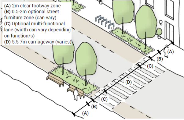
Links
|
Strategic Objectives |
|
|
Key Policy Links |
|
|
Evidence Base |
|
Supporting Sustainable Communities
POLICY SC1: COMMUNITY FACILITIES AND INFRASTRUCTURE Comment
- The provision of new or enhanced community facilities and infrastructure will be supported, whilst their loss, particularly where this would reduce the ability of local communities to meet their day-to-day needs, should be avoided.
- Proposals for new or enhanced community facilities and infrastructure that improve their quantity, quality, access and range, as well as meet an identified need, will be supported where they:
- prioritise and promote access by walking, cycling and public transport. Where facilities have a local or wider catchment area, access should be considered proportionately relative to their purpose and scale;
- are accessible for all members of society;
- are designed so that they are flexible and adaptable to accommodate a range of community uses, and can be easily altered to respond to future demands if necessary;
- where applicable, can be operated without detriment to neighbouring uses and properties. This especially applies to facilities which are open in the evening, such as leisure and recreation facilities;
- would be compatible with its surroundings with no unacceptable impacts on the character and appearance through the use of good design and siting;
- would be in conformity with other policies within the Local Plan and made neighbourhood development plans
- Where opportunities arise, the co-location of facilities will be supported, if it can be demonstrated that it improves access to facilities and results in most efficient use of land.
- Proposals that would lead to the loss of community facilities and infrastructure will only be permitted where:
- appropriate alternative provision is made; or
- it can be demonstrated that there is no longer a need for the facility to serve the community in its existing use or as an alternative community use; and
- all reasonable efforts have been made to retain the facility, and other community uses and community ownership and designation as an Asset of Community Value (ACV) have been considered; and
- it can be demonstrated that is no longer economically viable in its current use.
Explanation
4.1.394Community facilities and infrastructure within the District are varied and extensive and have an essential and indispensable role in creating and supporting sustainable communities and places. More broadly they form a key part of the area’s wider infrastructure provision. As part of planning the long-term development of Bradford District, it is essential to ensure that its communities have the appropriate infrastructure. The capacity, quality and accessibility of services and facilities are all key components in ensuring people can enjoy living, working and visiting the area.
4.1.395There are many existing facilities of varying scales and nature that are embedded across Bradford’s communities which provide for their ongoing health and well-being, social, educational, recreational, leisure, spiritual and cultural needs. Some of these, such as community centres or corner shops may only serve a very local community whilst others including schools, leisure centres or medical centres may cover a wider catchment or serve a cluster of settlements/communities. Some facilities such as hospitals, theatres or concert halls act as key facilities for the District as well as attracting people from beyond its boundaries across the wider West Yorkshire area.
4.1.396As part of promoting healthy and safe communities, national policy recognises the need to plan positively for the provision of community facilities and services to enhance the sustainability of communities and residential development. It also seeks to ensure that such facilities are preserved, and unnecessary loss be avoided[13].
4.1.397Having regard to national policy, the Plan seeks to support the provision of new or enhanced community infrastructure/facilities within the District and guard against the unnecessary loss of valued facilities and services, particularly where this would reduce the ability of local communities to meet their day-to-day needs.
4.1.398To be sustainable, suitable good quality facilities and infrastructure should be provided locally, and be located where they are accessible by walking, cycling and public transport. This particularly benefits those who are less mobile. In addition, facilities should be designed to be accessible to all sections of the community and be flexible enough to accommodate a range of community uses and adapt to changing requirements over their lifetime.
4.1.399New or enhanced community facilities and infrastructure should be of high-quality design that reflects and respects the character and appearance of their surrounding area. Proposals should include well-integrated facilities that allow effective use to made of buildings as community spaces. For example, this may include kitchen areas, toilets and washing facilities, communal areas, broadband connections, meeting spaces and appropriate storage spaces.
4.1.400Alongside the design of new or enhanced facilities, consideration should also be given, where appropriate to their operation and the wider effects that they could have on the amenity of surrounding areas and communities. Proposals should seek to ensure any adverse effects are minimised.
4.1.401As highlighted above, consideration should be given to designs that can accommodate a range of community uses and make them more adaptable to meet future needs. Providers and developers are encouraged to engage with each other to identify opportunities to enable the co-location or shared use of facilities. This can help to support the viability of facilities via increased usage.
4.1.402It is recognised that there may be instances where facilities become no longer fit for purpose and it can be demonstrated that there is no longer an existing or future community need for the facility, either in situ or elsewhere. Where the policy refers to 'proposals' this also includes proposals for the demolition, change of use and other forms of development that would result in the loss of an existing community facility.
4.1.403Where proposals involve the loss of community facilities infrastructure, the Council will need to be satisfied that adequate alternative provision has been made, or that there is evidence to clearly show that there is no longer a need for it (either in its existing form or for another community use) or that its use is no longer viable. It will need to be demonstrated that:
- the site or premises have been marketed to the Council's satisfaction for at least 12 months and included both traditional and web-based marketing, and regular advertisement in local, regional and/or national publications as appropriate,
- consultation with the local community has been undertaken;
- opportunities to re-let premises have been fully explored including the formation of a social enterprise or charitable group that can take over the premises;
- the premises/site has been marketed at a price which is commensurate with market values (based on evidence from recent and similar transactions and deals); and
- it has been demonstrated that the terms and conditions set out in the lease are reasonable and attractive to potential businesses, and that no reasonable offer has been refused.
4.1.404The Localism Act 2011 introduced the Community Right to Bid or Assets of Community Value (ACVs). It gives communities the right to identify a building or other land that is believed to be of importance to their social wellbeing. If the asset is listed for sale, the community is given a fair chance to bid to buy it on the open market, although the owner is not obliged to accept a bid. There is also no restriction on who the asset can be sold to. Should a nominated asset meet the definition of an ACV, the Council will list it. Such a listing may affect planning decisions – it is open to the Council to decide whether it is a material consideration if an application for change of use is submitted, considering all the circumstances of the individual case[14].
4.1.405The Local Infrastructure Plan (LIP) is central in ensuring the appropriate infrastructure, including community infrastructure, is delivered across the District to support the growth and development outlined in this Plan. Its preparation has involved working closely, with internal and external partners to identify the specific infrastructure projects and requirements to be delivered over the Local Plan period. The LIP, including the IDS, is a “live document”. It will be monitored, as part of the Annual Monitoring Report process, and reviewed and updated to ensure that appropriate infrastructure is delivered.
4.1.406It includes Infrastructure Delivery Schedule (IDS) that identifies what new or improved infrastructure is planned, who will be involved and the resource implications. It provides a detailed investment plan for infrastructure requirements in the District and will help the Council to negotiate levels of, and obtaining, planning contributions. It will also assist the Council in attempts to secure funding for infrastructure and key projects.
4.1.407Developers are encouraged to work collaboratively with the Council and other key stakeholders regarding the identification and meeting of community facilities and infrastructure needs that may arise from development. The Council will also continue to work closely with a wide range of providers in this regard.
4.1.408Where required, community infrastructure will be secured through developer contributions in line with the provisions of Policies ID1 and ID2.
Links
|
Strategic Objectives |
|
|
Key Policy Links |
|
|
Evidence Base |
|
POLICY SC2: CEMETERY AND BURIAL PROVISION Comment
- Proposals for new cemeteries or the extension of existing cemeteries will be supported provided that:
- it meets an identified need for additional burial space;
- the site is located in proximity to the communities it serves to reduce the need to travel;
- there would be no adverse impacts on the water environment, including water quality, water table or flood risk in the area, and would have suitable ground conditions;
- the use and operation of the site would have no adverse impacts on amenity and highways. They should also have adequate vehicular access and parking arrangements;
- the design approach, including the proposed layout and landscaping acts to minimise adverse impacts on the landscape or townscape;
- there is no adverse impact on the ecological or biodiversity value of the area; and
- there is no conflict between the proposed and neighbouring uses or any associated impacts on the amenity of residents or visitors to the cemetery.
Explanation
4.1.409Cemeteries and burial grounds provide a necessary community need. In addition, they also provide a valuable contribution to the District’s green infrastructure and ecological networks. Ensuring that the District has sufficient burial space to meet the needs of its communities is an essential role for the Council in discharging its duties under various acts of parliament.
4.1.410Bradford District has 67 sites classified as cemeteries, churchyards and burial grounds (44 closed churchyards and 24 municipal cemeteries). There are also three crematoria, two of which are in Bradford (Shay Grange and Bierley Wood), and one located at Oakworth. In recent years, the Council through its Bereavement Service Strategy has invested in new or refurbished crematoria facilities. The new Shay Grange was opened in 2023 to replace an older one at Nab Wood (Shipley), whilst Oakworth was refurbished and re-opened in 2022. A second new crematorium (Bierley Wood), opened in June 2026 on land at Shetcliffe Lane in Bierley on the southern edge of Bradford. This has replaced the Scholemoor facility.
4.1.411In terms of cemetery and burial space, sufficient capacity exists at Council-owned cemeteries to cover existing levels of activity beyond the end of the Local Plan period. The exception to this is the need to provide additional space for Muslim burials in the medium term.
4.1.412To address this an extension to the existing Muslim burial ground at Scholemoor Cemetery in Bradford was completed in 2020, whilst an extension of Bowling Cemetery has taken place. Other interventions proposed include the establishment of a new cemetery and the acquisition of land to allow further and larger cemeteries to be established.
4.1.413The Bereavement Service Strategy’s third phase involves the development of a major new cemetery in the District to delivery longer term capacity beyond 2050, subject to relevant planning consents and funding approval.
4.1.414It is essential that any new cemetery provision is located within proximity to the communities that it will serve, to reduce the need to travel, including vehicle use and trip numbers. Emphasis is placed on protecting the water environment, in particular ground water, and ensuring that sites have appropriate ground conditions. There may also be a need to apply for an environmental permit from the Environment Agency under certain circumstances. Details are provided in an Environment Agency guidance note[15]. Any proposals that come forward should also be compatible with their surrounding area including the landscape and/or townscape and neighbouring land uses. Potential impacts should be minimised or reduced by the inclusion of appropriate boundary treatments and landscaping.
4.1.415Where appropriate, any new cemetery sites or cemetery extensions should provide opportunities to enhance the District’s green infrastructure network through tree planting and landscaping and they should also support enhancements to wider ecological networks. Existing landscape features such as trees or hedgerows should be retained.
Links
|
Strategic Objectives |
|
|
Key Policy Links |
|
|
Evidence Base |
|
POLICY SC3: EDUCATION INFRASTRUCTURE Comment
- The development of new or enhanced early years, schools, post-16 and Special Educational Needs and Disabilities (SEND) provision will be supported in the District where it is clearly demonstrated that it will meet an identified need for existing and future residents for additional school places.
- New education facilities should be:
- Highly accessible to their intended catchments, particularly by walking, cycling and public transport.
- Located, designed and managed to minimise the impacts of associated traffic and car parking on the surrounding area.
- Of a high-quality design and of a scale that responds to its location and surroundings, including neighbouring buildings, townscapes and landscapes.
- Provide high-quality facilities appropriate to the number and age range of the pupils/students.
- Inclusive of outdoor/open space and playing fields that are sufficient to meet the needs of pupils/students.
- Fully accessible for all users including pupils/students, staff and visitors.
- Capable of a joint or dual use community benefit outside school hours, in agreement with the school/academy, with it being incorporated into the design.
- Where appropriate, developer contributions for education infrastructure will be sought where development proposals would result in additional pressures on school places.
- The role of the University of Bradford and the District’s Further Education Colleges as important centres for learning will be supported. Proposals for the continued enhancement of university and college facilities and campuses should:
- Form part of a comprehensive strategy to ensure that the evolution of their estates is properly co-ordinated and managed.
- Demonstrate high-quality design, including the use of sustainable design and construction, and have positive impact on the character and amenity of the surrounding area.
Explanation
4.1.416Ensuring that the District’s children and young people can access a high-quality education and educational facilities is an essential element in place making and creating places where people want to live. It is also important in supporting economic growth and prosperity, developing sustainable, strong and inclusive communities and sustaining quality of life. Education forms an important element of the Council’s Plan 2025 to 2030 and its Regeneration and Growth Plan (2025 to 2035), in particular making sure that residents have the skills needed for the future economy and that skill levels are increased.
4.1.417National policy highlights the importance of ensuring a sufficient choice of early years, school and post-16 places are available to meet the needs of existing and new communities. Planning authorities are encouraged to act in a proactive, positive and collaborative approach to meeting such requirements and to development that will widen choice in education. This includes:
- giving great weight to the need to create, expand or alter early years, schools and post 16 facilities through plan preparation and planning application decisions, and
- working with promoters, delivery partners and statutory bodies to identify and resolve key planning issues before applications are submitted.
4.1.418Accordingly, proposals for new or enhanced education provision will be supported, particularly where it meets identified needs and improves the scale, range, quality and accessibility to such facilities.
4.1.419In providing new or enhanced education facilities, consideration will need to be given to ensuring that they are situated in sustainable locations for them to be accessible for those living in the surrounding community, in particular by walking, cycling and public transport. Facilities should be of a high-quality of design that responds to their surrounding areas, whilst it will be important to provide appropriate facilities based on the number and age range of pupils or students, including open and outdoor space.
4.1.420The joint or dual use of education facilities can contribute to the availability of and accessibility to facilities and services for their surrounding areas. For example, facilities as school sports halls, playing pitches and changing rooms can often be under-utilised outside of school hours, and could be used to serve the community. Any such joint or dual use would be welcomed; however, this would need to be subject to an agreement with the school provider/management.
4.1.421It is recognised that new housing development has the potential to create demand for additional education places and/or increase pressure on existing education facilities. To address this, developers may therefore be required to make contributions. This may include making financial contributions to the provision of additional school places and/or setting aside an area of land or space within the proposed development to allow a new facility to be constructed. In most instances the former approach will be taken, although the latter may be appropriate in certain circumstances. The need for school places arising from development both within and immediately adjacent to the relevant catchment area will be considered on a site-by-site basis having regard to the capacity of existing education provision within the area.
4.1.422The Local Infrastructure Plan, which accompanies the Local Plan, seeks to ensure that appropriate infrastructure is provided across the District to support future growth and development, including education facilities. Where appropriate, it identifies where additional provision may be required. In all cases developers are advised to engage with the Local Education Authority when preparing their proposals.
4.1.423Where the need for additional school places is identified because of the pressure on places from development either individually or due to multiple developments within an area, requests for proportionate developer contributions will be sought.
4.1.424Engagement will continue to take place with neighbouring Local Education Authorities, particularly North Yorkshire and Leeds to identify any impacts on the cross-boundary movement of pupils to/from the district.
4.1.425The University of Bradford and Further Education colleges - Askham Bryan, Bradford, Keighley and Shipley - play a major role in the District’s economy and are important in helping to deliver economic and social transformation. This includes making sure that the District’s population has the right skills to access employment opportunities and meets the needs of employers.
4.1.426The University has a student body of 11,600 and employees 1,700 staff, whilst the colleges have a combined body of 30,150 learners. A range of investments have been made in the facilities as part of each campus over recent years. The University and Bradford College are located within the Knowledge Quarter Regeneration Area (as identified in Policy BCC1).
4.1.427The policy seeks to integrate the District’s higher and further education institutions into the wider spatial planning of the area, recognising their role as centres of learning and important economic assets.
Links
|
Strategic Objectives |
|
|
Key Policy Links |
|
|
Evidence Base |
|
POLICY SC4: PROVISION OF HEALTH INFRASTRUCTURE Comment
- Proposals for new or enhanced health care facilities in the District will be supported where it is:
- Clearly demonstrated that it will meet an identified need for additional provision.
- Of a high-quality design and of a scale that responds to its location and surroundings, including neighbouring buildings and townscapes.
- Highly accessible to its intended catchment, particularly by walking, cycling and public transport.
- Fully accessible to all sections of the community.
- Proposals that seek to utilise innovative means of delivering health services and infrastructure will be supported. This includes encouraging opportunities for the multi-use and co-location of health facilities with other services and facilities, co-ordinating local care and providing convenience for the community.
- The roles of Bradford Royal Infirmary, St Luke’s Hospital, Airedale General Hospital, Lynfield Mount Hospital and the Airedale Centre for Mental Health as key facilities for the District and beyond will be supported. Proposals for future hospital development should:
- Form part of a comprehensive development strategy or masterplan to ensure the estates are properly co-ordinated and managed.
- Ensure that buildings and wider urban design is of high quality
- Ensure that staff, patients and visitors can effectively access the hospital by public transport, cycling and walking and
- That negative impacts of traffic and car parking are minimised.
Explanation
4.1.428The health and wellbeing of the community is a key issue to be addressed in the Local Plan. National planning policy requires local planning authorities to understand and facilitate local healthcare strategic priorities. It is essential therefore that communities have access to high-quality health care services (either primary or secondary care facilities). This means working closely with a wide range of partners including the National Health Service (NHS).
4.1.429Bradford District has several health challenges in the need to address health inequalities. The Bradford District Joint Strategic Needs Assessment (JSNA) is a living document that sets out a range of information that is used to help commission health services in the area.
4.1.430Nationally, the NHS is rolling out the Neighbourhood Health Framework[16]. This represents a major shift in the way healthcare is provided with the aim of bring care closer to where people live, strengthening prevention and joining up services across various elements of the NHS, local government, social care and voluntary sector. There are also plans to build 250 Neighbourhood Health Centres in England by 2035, of this 120 would be delivered by 2030, as a means of bring services closer to residents and reduce waiting lists[17].
4.1.431Bradford District and Craven Health and Care Partnership is one of 43 sites nationally that are taking part in Wave One of the National Neighbourhood Health Implementation Programmed (NNHIP). Within this, two areas have been selected to be part of the NNHIP work – Bradford South and Keighley and Airedale. These cover five Primary Care Networks and four Community Partnerships[18].
4.1.432Primary care is generally the first point of contact between local people and health professionals. The Council will continue to work with the West Yorkshire Integrated Care Board, Bradford District and Craven Health and Care Partnership, Primary Care Networks, and other health care providers to ensure that the capacity and quality of health care facilities within District meets the requirements of the current and future population and their changing needs. There are 71 GP practices organised into 12 Primary Care Networks (PCNs).
4.1.433The District’s major hospitals – Bradford Royal Infirmary, St Luke’s Hospital and Airedale General Hospital – provide a comprehensive range of services to the population of Bradford District as well as further afield. The NHS Trusts that run them are also major employers. Both trusts have experienced issues with their estate over recent years. Lynfield Mount Hospital (Bradford) and the Airedale Centre for Mental Health (Steeton with Eastburn), both of which are operated by the Bradford District Care NHS Foundation Trust provide mental health care services.
4.1.434Airedale NHS Foundation Trust’s main hospital facility (Airedale General Hospital) is located in Steeton with Eastburn and serves a population of over 200,000 people from a widespread area covering 700 square miles within West and North Yorkshire and East Lancashire. The hospital is one of a several in England constructed from Reinforced Autoclaved Aerated Concrete (RAAC). Accordingly, building a new hospital is an urgent priority for the Trust. Proposals are being developed for a new hospital using the nationally developed “Hospital 2.0” template and this forms part of the first phase of the Government’s New Hospitals Programme. It will include a focus on being environmentally friendly and the use of latest digital technology. Construction is expected to commence in 2028.
4.1.435Bradford Teaching Hospitals NHS Foundation Trust (BTHFT) operates five hospitals including Bradford Royal Infirmary (BRI) and St. Luke’s Hospital as well as Eccleshill Community Hospital, Westwood Park Community Hospital and Westbourne Green Community Hospital. It serves a core population of around 500,000 as well as providing specialist services for some 1.1 million people. The Trust has developed, and invested in, its facilities, however it requires on going renewal to support the delivery of future healthcare. It has also embarked on a programme of works to improve and future-proof the built environment. The age of the estates and constrained nature of the BRI and St. Luke’s sites is also a challenge.
4.1.436Lynfield Mount Hospital (Bradford) is to be rebuilt in a £65 million investment that will improve facilities for service uses and staff. It includes refurbishment of existing buildings, upgrades to existing ward accommodation, construction of new ward block and creation of safe outdoor garden spaces and recreational areas. Completion is expected in 2029.
4.1.437Where proposals for new or additional health care facilities and infrastructure come forward, they should be located where they can be served by existing and/or future public transport services or well-related to existing and/or future walking and cycling routes. Where appropriate, opportunities for the multi-use and/or co-location of facilities with services, in accessible locations, will be supported, to assist in the co-ordination of local service provision and allow greater convenience for residents.
4.1.438Developers should have regard to the Local Infrastructure Plan. This sets out information about infrastructure capacity in the District and identifies infrastructure required to support development over the Local Plan period, alongside costs and responsibility for delivery. Engagement with health care providers at an early stage in developing the proposals is also advised.
Links
|
Strategic Objectives |
|
|
Key Policy Links |
|
|
Evidence Base |
|
POLICY SC5: SPORTS AND RECREATION PROVISION Comment
- Development proposals for residential and other developments as appropriate will:
- Safeguard existing sports and recreation facilities in accordance with national policy and have regard to the Council's Integrated Sports Assessment (ISA), or any subsequent update.
- In line with Policies NE2, ID1 and ID2 and in accordance with the needs identified in the Council's Integrated Sports Assessment (ISA), make provision on site for sports and recreation facilities whilst ensuring that the location of new facilities is sustainably located and in accordance with other policies in the Plan.
- Where it is not appropriate to make provision for new sports and recreational facilities on site, off-site contributions will be required to contribute towards meeting:
- Local sport facility deficiencies as identified through the ISA and as agreed with the Council and relevant sport organisations.
- Where this is not feasible, the qualitative or quantitative improvement of existing sustainably located provision in other parts of the District.
- Development on existing sport and recreation facilities will only be permitted where:
- A robust assessment has been undertaken that clearly demonstrates the site to be surplus for use for its current sport or recreation function; or
- Any loss in provision would be replaced by equivalent or better provision in terms of quality and quantity in a suitable sustainable location, or support reprovision towards larger or integrated sport facilities through developer contributions; and
- In circumstances where the sport or recreation facility has been demonstrated to be surplus to need for that function in accordance with part 2 (a) of this policy, any proposed replacement will remedy a deficiency in another type of sport or recreation facility in the local area.
- Developer contributions will be required to enhance existing provision of sports and recreation facilities, based on the additional demand generated by the new residential development and the sufficiency of existing provision to meet current and projected need as identified through the Integrated Sports Assessment (ISA) and subsequent strategies / action plans.
- The Council will support proposals for the delivery of multi-use of sports and recreational facilities as appropriate, with particular emphasis on contributing toward the Local Plan Open Space priorities and Green and Blue Infrastructure Strategy to achieve benefits for both communities and biodiversity.
Explanation
Sport, Health and Communities
4.1.439One of the core planning principles in the Framework is to improve health, social and cultural wellbeing for all. In terms of promoting healthy and safe communities the NPPF recognises that access to high-quality open spaces and opportunities for sport, recreation and physical activity can make an important contribution to the health and wellbeing of communities. It advises that assessments should identify specific needs and quantitative or qualitative deficits or surpluses of open space, sports and recreation provision and use these assessments to determine what open space, sports and recreation provision is required, which the Local Plan should seek to accommodate.
4.1.440The NPPF also advocates that existing open space, sports and recreational buildings and land, including playing fields, should not be used for built development other than in exceptional circumstances.
4.1.441Open space, sports and recreation provision play an important role in the sustainable development of settlements. There is a growing body of evidence that shows the importance of providing good quality and publicly accessible sport, recreational and open space and that these provisions provide a number of quality-of-life benefits to communities including:
- providing the opportunity for people to live active and healthy lifestyles, encouraging physical activity;
- helping improve mental and physical health, providing a connection to the natural environment, supporting wildlife and biodiversity; and
- helping to mitigate against the impacts of climate change.
4.1.442Attractive, safe, accessible, and well-maintained open space, sports and recreation facilities are also essential to support the council’s active and healthy lifestyles ambitions and are critical in ensuring opportunities at all levels for sport and recreation.
4.1.443The retention of the vast majority of existing open space and sports and recreation facilities, making improvements to the quality and nature of the resources and meeting the existing and future needs of a growing and diverse population are therefore important challenges that need to be addressed in order to provide a good quality of life for the District’s residents.
Local Context
4.1.444The District’s population has historically seen lower than national and regional average levels of use of outdoor space for exercise / health and participation physical activity. Generally, activity levels are lower in females than males.
4.1.445The Bradford District is in a particularly good position to benefit from increasing physical activity:
- There are high levels of urban deprivation, childhood obesity, diabetes and preventable deaths (particularly from cardiovascular disease) in the district.
- There is a low level of physical activity but the will to become more active is present as the proportion of people wanting to do more activity in the district is the same as nationally.
4.1.446Innovative focused activity programmes can however make a real difference to increasing activity levels and health overall. The JU:MP programme[19] funded by Sport England has been working closely with communities in specific multi-cultural and economically deprived communities in Bradford over the last five years to give children and their families more opportunities to be active, with positive results for children’s total physical activity levels, increased levels of moderate to vigorous activity and reduced inactivity[1].
4.1.447The Bradford Council District Plan (2025-30)[20]has a strong focus upon tackling health inequalities with one of its priority outcomes being for residents to achieve good health and wellbeing and increase participation in sports, leisure and physical activity programmes.
4.1.448The better health / better lives agenda forms part of a much wider portfolio of plans and strategies including:
- Health and Wellbeing Strategy
- Children’s Services Improvement Plan
- Bradford Children, Young People and Families Plan
- Health & Wellbeing – (Adult Social Care) - Commissioning Strategy and Intentions 2019 – 2021
- Mental wellbeing in Bradford district and Craven: a strategy 2016-2021
4.1.449The Active Bradford strategy ‘Every Move Counts’[21] provides a comprehensive physical activity strategy for Bradford District and Active Bradford acts as the District Activity Partnership. Physical activity programmes in the strategy cuts across a number of priority and policy areas but the strategy includes a specific sport and active recreation priority. The ambition in the strategy is to build on current provision to increase community access to local settings for sport such as schools, sports centres and parks.
4.1.450One of the aims is to proactively engage new groups and organisations who can deliver activities to reach new audiences and tackle inequalities. Promoting informal active recreation and different kinds of exercise to engage those who may be less active, such as women and girls, will be a key. Bradford’s vibrant and appealing mass participation events will continue to be a priority with new opportunities sought to further develop them.
4.1.451Yorkshire Sport Foundation[22] is the active partnership covering South Yorkshire and West Yorkshire. The priorities of the partnership in terms of vision themes include a focus upon active communities, healthcare and active design, active travel, workplaces and schools and sport and public campaigns.
Bradford District Integrated Sport Assessment
4.1.452To understand current provision and identify future needs for sports and recreation provision the Council commissioned an Integrated Sports Assessment (ISA) that consists of a Playing Pitch and Outdoor Sport Strategy (PPOSS) and anIndoor Sports and Built Facilities Strategy (ISBFS), together with strategy / action plan work in compliance with Sport England guidance. For the PPOSS / ISBFS assessments the study included a focus upon an audit of current provision (quantity, quality, accessibility), a review of current demand and future demand together with extensive stakeholder engagement.
4.1.453The studies have generally identified a need to protect all forms of provision, improve the quality and value of existing provision, improve the maintenance of provision, as well as a need to provide additional provision and associated facilities. This will support the growth in population and sport participation levels associated with the development in the Local Plan over its plan period.
4.1.454The PPOSS provides a supply and demand assessment of playing pitch provision across the District and has identified a need to protect all existing playing pitch provision and increase capacity through creating or enhancing access to school sites or bringing disused sites back into use, where feasible. Within the PPOSS the study included sports / facilities covering athletics, cricket, football, hockey (artificial grass facilities), bowling greens, netball, tennis courts (including padel), rugby league, rugby union, third generation turf (3G) pitches and golf. Non-pitch sports (i.e. tennis, bowls, athletics, netball) are assessed using Sport England’s Assessing Needs and Opportunities Guidance (ANOG) to ensure the process is compliant with National Planning Policy Framework (NPPF).
4.1.455Key PPOSS findings applied with housing growth factored in:
- Significant needs identified for pitches across adult football, youth football and mini soccer.
- Significant changing facilities needs identified for adult and youth football.
- Needs identified for pitches and changing rooms across Rugby Union and Rugby League.
- Needs identified for pitches and changing rooms for cricket
- More limited additional need for 3G artificial grass pitches and supporting facilities
4.1.456Work on strategy development and action planning will look at priorities in detail and opportunities to improve provision in conjunction with stakeholders and sport organisations. The Local Plan has a key role to play in providing the right policy framework and identifying site / development opportunities.
4.1.457In addition to PPOSS, the Council has also prepared a Playable Spaces Strategy which sets out how the Council will prioritise the refurbishment and enhancement of the range of play facilities that it manages across the District and to set out a spending and delivery programme.
4.1.458The ISBFS has identified a need to optimise the use of existing sports halls and/or centres or where new development and ongoing growth indicates a requirement to provide new opportunities for purpose-built community facilities.
4.1.459In line with identified needs, the Draft Indoor Sports Facilities Strategy highlights requirement to prioritise investment in council-managed sports facilities to improve quality, accessibility, customer experience and operational efficiency. The strategy also has a particular focus on facilities identified as below average or where condition surveys highlight significant future maintenance requirements. In the medium term, substantial refurbishment, major modernisation and/or replacement of Eccleshill Swimming Pool, Ilkley Swimming Pool and Shipley Pool & Gym is likely to be necessary, reflecting their age and the scale of investment likely to be needed to maintain their long-term viability. In addition, the evidence suggests there is a need for a planned and substantial programme of lifecycle investment across sports halls, swimming pools and health and fitness facilities to address ageing infrastructure, maintain service quality and reduce future maintenance liabilities.
4.1.460Given the levels of demand and deficiency for sports and recreational facilities within some parts of the District, and the important role that these provisions play for people and the environment, Policy SC5 provides protection against the loss of these existing facilities, where they are required to meet current and future needs and demands. The provision and access to such sites and facilities is important in ensuring communities can participate in active and healthy lifestyles. Policy SC5 therefore restricts the loss of sport and recreation sites and sets out the exceptions tests where losses may be acceptable.
4.1.461New residential development will generate additional demand for sports and recreation facilities, so new provision or a contribution to increase capacity of an existing site(s) may be required to accommodate this additional demand. Policy SC5 sets out the need to provide such facilities as part of development proposals and highlights the requirement to address deficiencies, with reference to the Council's Integrated Sports Assessment (ISA) and with full consideration of the relevant criteria of Policy NE2 and Appendix 11– ensuring that adequate and appropriate provision is made. This will further be subject to meeting other development plan policies, including proposals being appropriately located, accessible by a range of transport modes and appropriately designed.
Planning Applications and Sport Infrastructure
4.1.462The actual amounts of provisions required will be determined at planning application stage and on a case-by-case basis, informed by the most up to date evidence base and in the context of the specific details of the proposed development. In this respect, when new developments occur the policy seeks to ensure that provision does not fall below current levels. Additionally, in order to facilitate, where feasible, integration of sports and recreational provision into the Local Plan open space/green infrastructure network, the Policy advocates the multi-use and functioning of spaces to achieve benefits to communities and to biodiversity (through the creation of natural habitats) in accordance with Policy NE4 of the Local Plan.
4.1.463To determine an appropriate amount and type of contribution or provision with new development, the Council will use the findings from the Integrated Sports Assessment (ISA), with associated strategy plans to determine how additional demand should be met.
4.1.464In relation to increasing capacity of an existing provision the Council will seek to achieve this by working with stakeholders and sports organisations to enhance the quality, accessibility, range (including changing room provision) and maintenance of sport sites and secure greater community access, subject to relevant Local Plan policies.
4.1.465When a development proposal requires replacement or on-site sport pitch provision, the Council may require the applicant to provide additional information, such as a Feasibility Study and/or Agronomy Report, to assess suitability of the site to accommodate the pitch. The Council may stipulate requirements of new pitch provision through planning conditions.
4.1.466Major strategic development, if requested to provide indoor sports facilities, will be required to ensure that community buildings are delivered with appropriate facilities suitable for multiple indoor sports and daytime activities in line with Sport England guidance. Large scale regeneration areas are likely to require the provision of new sports infrastructure to support residents and the delivery of an integrated approach to place-development.
Links
|
Strategic Objectives |
|
|
Key Policy Links |
|
|
Evidence Base |
|
POLICY SC6: DIGITAL AND TELECOMMUNICATIONS CONNECTIVITY Comment
- The development and expansion of advanced, high-quality digital and communications infrastructure networks in Bradford District, where practical, will be supported. This includes the improvement and rollout of high capacity, ultrafast and affordable digital infrastructure including fibre broadband infrastructure and services, enhancing existing 4G coverage in urban and rural areas, extending and enhancing 5G coverage and supporting, where necessary other wireless and satellite-based technologies.
- Proposals should include appropriate measures to enable full fibre broadband or equivalent gigabit capable infrastructure connectivity to all end users. It should be demonstrated that the development will be connection ready on first occupation. Early engagement with providers will be encouraged and should address the issue of open access encouraging consumer choice of service providers.
- Proposals for new telecommunications infrastructure and equipment should demonstrate that:
- For new mobile installations, it has processed an exercise of pre-consultation with the Council to inform site selection and any subsequent planning application.
- It is of the minimum standard required to meet operational requirements, having regard to future demand or planned improvements.
- Opportunities for mobile infrastructure and equipment sharing, use of existing buildings, use of other appropriate structures including use of street assets for small cell deployment or integrating the installation into new development, have been fully investigated and taken into consideration, before identifying the need for new sites.
- It is sensitively located and appropriately designed having regard to:
- The need to avoid unacceptable harm to the character or appearance of the area or the host building or structure on which the infrastructure and equipment is located;
- The need to avoid adverse effects on the quality or special interest of any environmentally sensitive areas, including open spaces and biodiversity assets such as the South Pennine Moors Special Protection Area and Special Area of Conservation;
- The need to preserve and enhance the significance of designated and non-designated heritage assets and their settings;
- Avoiding significant adverse impacts on the amenity of the occupiers of the host building and, where appropriate, occupiers of neighbouring properties as well as the wider area;
- The cumulative impact of telecommunications installations on a structure, site or area.
- Is certified to be in conformity with latest national guidelines on radiation exposure
- Street clutter is limited through minimising the number, size and prominence of equipment cabins; and
- It does not impede pedestrian movement or compromise highway safety.
- To minimise visual impact all infrastructure and equipment should be removed as soon as reasonably practicable once it is no longer required for use, and the site restored.
Explanation
4.1.467Digital connectivity and high-quality communications infrastructure play an important role in society and how it functions, in particular how infrastructure and services are provided. It offers opportunities for residents to be better connected, access digital services and can generally improve the wellbeing of communities as well as enabling social inclusion. It can be a driver for increased productivity, economic growth and job creation as well as enabling flexible approaches to work.
4.1.468It also has implications for physical connectivity and the transport network. For example, new technologies have changed the way in which people work and commute, including reducing the need to travel. Smart technologies are supporting efficiencies in the distribution and logistics sector, with improved timing and co-ordination in servicing and deliveries.
4.1.469Nationally, Government has a target of gigabit broadband being available to 99% of UK premises by 2032. The expansion of electronic communications networks including next generation mobile technology and full fibre broadband connections is supported by national planning policy, whilst amended Building Regulations were introduced in 2022 requiring gigabit broadband infrastructure and connectivity in the construction of new homes. The aim is to ensure they are installed with the fastest possible broadband connections available within a cost cap, or to be future proofed with the infrastructure to support such connections, where gigabit connections are not possible within the cost cap.
4.1.470The policy also aligns the Council’s Regeneration and Growth Plan (2025) and the Bradford District Digital Strategy (2022 to 2027). The former recognises the importance of digital (including full fibre broadband) and enhanced mobile connectivity underpinning smart city technologies, advanced manufacturing, automation, connected healthcare and creative industries. It also enables innovation and supports increased productivity. The latter seeks to support the District’s transition towards an area where the best of digital and smart technologies improves the lives of residents and support the delivery of Clean Growth.
4.1.471However, support for enhanced digital and telecommunications connectivity must be balanced against the need to ensure that any new or enhanced provision does not have any significant adverse impact on the District’s natural and built environment as well as its communities.
4.1.472Accordingly, it is important the infrastructure and equipment are of a high-quality design and managed in an appropriate way. This will ensure that development does not adversely affect amenity, local character, heritage assets, open spaces and biodiversity as well as the functioning of the public realm. This should clearly be demonstrated as part of any proposals that may come forward.
4.1.473Proposals should be sited and designed to avoid or have the least detrimental impact on the wider environment including addressing visual impact and responding positively to local character. This includes the significance of heritage assets and their settings. Consideration should be given to keeping new installations to a minimum, consistent with the efficient operation of networks, and making use of existing equipment, buildings and structures. Where new sites are needed, equipment should be sympathetically designed and concealed using appropriate design treatments to camouflage it including colour, landscaping and screening.
4.1.474Development is required to have regard to the latest guidelines of the International Commission for Non-Ionising Radiation Protection. These guidelines are for the protection of humans exposed to electric and magnetic fields in the low-frequency range of the electromagnetic spectrum. They are intended to provide protection against all established adverse health effects.
4.1.475Some digital and electronic communications developments do not require express planning permission due to the provisions of the Town and Country Planning (General Permitted Development) (England) Order 2015 (as amended). However, the Council is able to exercise some control over siting and appearance of these developments. In such circumstances, the policy outlined above will apply.
4.1.476Applicants, developers and providers should consider co-ordinating the provision and implementation of digital and telecommunications and other utilities infrastructure, such as connections to the electricity, gas and water supply, to ensure that they are designed into new development to reduce impacts on the wider area.
Links
|
Strategic Objectives |
|
|
Key Policy Links |
|
|
Evidence Base |
|
Climate & Resources
POLICY CR1: AIR QUALITY Comment
Strategic Approach
- The Council is committed to maintaining and improving air quality across the District to protect human health, wellbeing and the environment. The Council will work collaboratively with partners and stakeholders to implement Clean Air Plans and Strategies[23] ensuring that the individual and cumulative impacts of development are minimised and mitigated, and that public exposure to poor air quality is reduced.
Air Quality Exposure and Protection of Sensitive Receptors
- Any developments which introduce new relevant receptors and are likely to give rise to material air quality exposure will be required to submit an Exposure Assessment.
- The location of new homes and other sensitive uses, including schools, care homes, hospitals and outdoor recreation spaces, must be assessed with regard to the proximity to:
- existing roads;
- industrial and commercial activities (including quarries);
- combustion processes; and
- agricultural emission sources
- All development proposals must incorporate design measures to minimise exposure to air pollution (including PM2.5), including (where appropriate):
- building orientation and internal layout;
- physical separation distances and buffer zones; and
- the use of landscaping and appropriate green infrastructure
- Any developments which are likely to give rise to material air quality impacts on existing sensitive receptors will be required to submit an air quality impact assessment and damage cost calculation, proportionate to the scale and nature of the proposal.
- Industrial, combustion or emissions‑generating developments must be appropriately located and robustly screened and assessed to ensure that they do not cause unacceptable additional public exposure to air pollutants.
- Where a development has access to the electricity and/or gas grid, proposals should be designed to prioritise low emission and non-combustion heating solutions. The use of solid fuel or wood burning combustion appliances will not be supported unless it is clearly demonstrated that their inclusion would not result in adverse air quality or public health impacts.
- Green infrastructure proposals must be designed to maximise air quality co‑benefits, with careful consideration given to species selection, location and function of planting.
Major Development (District‑wide)
In addition to the above, major development should also:
- Incorporate low‑emission mitigation measures to offset any additional emissions to air arising from the development in accordance with the Bradford Low Emission Strategy Planning Guidance (as updated or superseded)
- where provision is required to reduce emissions, this should normally be made on‑site
- where it can be demonstrated that on‑site provision is impractical or inappropriate, equivalent air quality benefits should be provided off‑site or as a financial contribution made towards alternative emission offsetting within the vicinity of the site
- Consider cumulative air quality impacts at the design and assessment stage.
- Avoid unacceptable increased exposure for the natural environment, particularly sensitive habitats and designated sites of importance for biodiversity.
- Employ sustainable design and utilise Construction Emission Management Plans to reduce air pollutant emissions arising from the demolition and construction of buildings.
- Have site‑specific EV charging strategies appropriate to the size and scale of the development (except for new housing developments, which need only comply with Building Regulations (Approved Document S or future iterations)).
Proposals for Biomass Boilers
- Proposals for biomass boilers must demonstrate, through a proportionate assessment, that they would not result in unacceptable adverse impacts on air quality or public health, having regard to cumulative effects and the presence of sensitive receptors.
- Where biomass boilers are proposed at a scale or in a location where air quality impacts may be materially significant, including where residential receptors may be affected, assessment should include use of the Defra Biomass Emissions Screening Tool, to determine whether detailed dispersion modelling is required.
- Within or adjacent to residential areas, biomass boilers will be supported only where it is clearly demonstrated that emissions can be effectively controlled and that there would be no unacceptable increase in public exposure to air pollutants.
- Proposals must demonstrate that lower‑emission or non‑combustion heat alternatives have been considered, particularly in residential locations.
Clean Air Zone (CAZ) – Enhanced Requirements
- Within the Clean Air Zone, as identified on the Policies Map, and while the CAZ remains in force, enhanced and more stringent measures will apply. In addition to the requirements of Section C, major development within the CAZ must demonstrate, through provision of a quantitative emission reduction strategy that it will:
- achieve a high standard of mitigation, ensuring emissions are minimised beyond District‑wide requirements and actively contribute to local air quality improvement
- avoid the use of biomass boilers or solid fuel appliances and instead maximise renewable and low‑carbon energy
Explanation
4.1.477Evidence demonstrates that exposure to air pollution is associated with a wide range of adverse health outcomes, including respiratory and cardiovascular disease, reduced life expectancy and impacts on child development. These effects disproportionately impact vulnerable populations such as children, older people, those with existing health conditions and communities experiencing deprivation, contributing to health inequalities across the District.
4.1.478Development can affect air quality through traffic generation, combustion-based energy systems, construction activity and the siting of sensitive uses near existing pollution sources. National policy requires planning decisions to ensure that development is appropriate for its location, considering the likely effects of pollution on health, living conditions and the natural environment, and to mitigate and, where possible, reduce adverse impacts. This policy provides a local framework to deliver that requirement.
Strategies and Proposals
4.1.479In the UK, concentrations of a range of pollutants in ambient air are regulated by The Air Quality Standards Regulations (AQSR) (2010). These regulations set ‘limit values’, ‘target values’, ‘long-term objectives’ and ‘critical levels’ for ambient concentrations of pollutants.
4.1.480Limit values must not be exceeded. They are set for individual pollutants and comprise a concentration value, an averaging period for the concentration value, a number of exceedances allowed (per year) and a date by which this must be achieved. Some pollutants have more than one limit value, for example relating to short-term average concentrations (such as the hourly mean) and long-term average concentrations (such as the annual mean).
4.1.481The UK government is legally required to meet the limit values. Target values are set for some pollutants and are configured in the same way as limit values. The UK government is legally required to take all necessary measures not entailing disproportionate costs to meet the target values. Local Air Quality Management (LAQM) provides the framework under Part IV of the Environment Act 2021 within which air quality is managed by local authorities to assist with national compliance with air quality standards.
4.1.482Under the LAQM regime all local authorities are required to report annually on air quality in their areas and to implement local polices and strategies to improve air quality. Progress must be reported against ‘Air Quality Objectives’ as set out in the Air Quality (England) Regulations 2000, as amended. These ‘objectives’ are similar to the legally binding limit values and target values set out in the Air Quality Standards Regulations but only cover pollutants that can be reasonably controlled at a local level and only apply at ‘relevant locations’. At relevant locations where air quality objectives are not met an Air Quality Management Area (AQMA) must be declared and an Air Quality Action Plan (AQAP) put in place to improve air quality through planning policies, transport policies and public awareness/education activities. Bradford currently has four AQMAs in place. The Council has prepared both an Air Quality Strategy (2011) and Low Emission Strategy (2013) setting out its commitment to taking a pro-active stance in addressing air quality issues. As the impact of transport is a cross-boundary issue, the five West Yorkshire Local Authorities have prepared the West Yorkshire Low Emissions Strategy (2016-2021) which outlines the key challenges in relation to air quality within West Yorkshire.
4.1.483Where the government considers there is still a risk of air quality limit values being exceeded it must draw up a national air quality plan and can mandate local authorities to implement further air quality improvement plans. The UK government prepared a UK Air Quality Plan for nitrogen dioxide (2019) and a Clean Air Zone Framework as part of its response to addressing air quality breaches across the country and to comply with EU legislation on Limit Values[24]. As part of this process Bradford was mandated to implement a charging Clean Air Zone (CAZ) in 2020. The CAZ commenced in September 2022 and certain non-compliant vehicles, excluding private cars, are subject to a daily charge.
4.1.484The Environment Act 2021 introduced further legally binding national air quality targets for England, particularly for fine particulate matter (PM2.5), which is the most harmful pollutant to health. Targets include:
- Annual mean PM2.5 concentration of no more than 10 µg/m³ by 2040.
- Population exposure reduction of 35% by 2040 (compared to 2018 levels).
4.1.485As there are no known safe limits for PM2.5 planning guidance requires exposure to PM2.5 to be reduced as far as possible on all new developments through good site design.
Air Quality in Bradford
4.1.486The Council has a proven track record of positive action to improve air quality, including the implementation of the Bradford Clean Air Plan and the introduction of a District‑wide CAZ.
4.1.487Monitoring and evaluation show that these measures have delivered substantial reductions in nitrogen dioxide concentrations and early, measurable improvements in public health outcomes. However, air pollution continues to pose risks in some locations, particularly from fine particulate matter (PM2.5), for which there is no identified safe threshold. Continued intervention through the planning system is therefore essential to secure further improvements and prevent new or avoidable exposure arising from development.
4.1.488Further improving and maintaining good air quality within Bradford District is a key priority and the Local Plan can influence air quality through several policy areas and measures including:
- where development is located and how it is supported – overall growth and distribution strategies and proximity to services, facilities and travel options;
- the types of places that are built – development of active healthy streets, levels of green infrastructure and open space;
- effective infrastructure planning – to provide real alternatives to private car use through developing bus and rail options and cycling and walking alternatives
Air Quality Exposure and Protection of Sensitive Receptors
4.1.489Design‑led solutions are prioritised as an effective and durable means of reducing exposure. Measures such as building orientation and layout, separation distances, buffer zones and the use of appropriate green infrastructure can significantly influence pollutant dispersion and exposure, including to PM2.5. The policy therefore requires these issues to be addressed at an early stage in the design process, rather than relying solely on technical mitigation measures.
4.1.490Where development introduces new sensitive receptors that may be exposed to poor air quality, or where proposals may increase pollution affecting existing receptors, proportionate assessment is required. The use of Exposure Assessments, Air Quality Impact Assessments and damage cost calculations ensures that potential impacts are properly understood, cumulative effects are considered and appropriate mitigation is secured. This approach aligns with established planning practice in the District and provides clarity and consistency for applicants and decision‑makers.
Major Development
4.1.491Major development is expected to demonstrate a higher standard of performance, reflecting its greater potential to generate emissions and cumulative impacts. The requirement to incorporate low‑emission mitigation measures in accordance with the Bradford Low Emission Strategy Planning Guidance ensures that additional emissions are addressed in a transparent and proportionate way. While on‑site mitigation is preferred, the policy provides flexibility for equivalent off‑site measures or financial contributions where on‑site provision would be impractical or inappropriate, ensuring that meaningful air quality benefits are still delivered locally.
4.1.492The policy supports the transition to low-emission development by prioritising non-combustion heating solutions where electricity, gas or district heating networks are available. Solid fuel and woodburning appliances are not supported unless it is clearly demonstrated that they would not result in adverse air quality or public health impacts, reflecting both local evidence and the need to prevent incremental deterioration in air quality.
Proposals for Biomass Boilers
4.1.493Specific criteria guide the assessment of biomass boiler proposals. While biomass may offer carbon benefits in some circumstances, the policy adopts a precautionary approach to ensure that installations do not cause unacceptable localised impacts, particularly in or near residential areas. Proposals must demonstrate that lower-emission or non-combustion alternatives have been considered and that cumulative effects and sensitive receptors have been considered.
Clean Air Zone (CAZ)
4.1.494Enhanced requirements apply within the CAZ, whilst it is in force, reflecting the historic concentration of air quality issues, high pedestrian activity and the presence of sensitive receptors. Development in the CAZ must achieve a higher level of mitigation and avoid solid fuel and biomass combustion. This ensures that development actively supports local air quality improvement rather than merely avoiding harm, in line with national policy to improve environmental conditions and human health.
4.1.495Overall, the policy provides a clear, proportionate and locally evidenced framework to ensure that development across the Bradford District protects health, reduces inequalities and contributes positively to clean air objectives while supporting sustainable growth.
Links
|
Strategic Objectives |
|
|
Key Policy Links |
|
|
Evidence Base |
|
POLICY CR2: ENVIRONMENTAL PROTECTION Comment
- Developments which are likely to cause pollution or are likely to result in exposure to sources of pollution (including noise, odour, vibration, dust, light, water or soil pollution) or risks to safety, will only be permitted where it can be demonstrated that any unacceptable risks are avoided or appropriately mitigated, ensuring the development is suitable for its location and provides a high standard of protection for health, environmental quality and amenity. The following issues require particular attention:
Land Contamination and Stability
- Development on land that is unstable, contaminated, or suspected of being contaminated due to its previous use, history or geology, must be supported by a proportionate, risk-based assessment, demonstrating that the site is suitable for its intended use, including consideration of risks to human health, controlled waters, property and the wider environment.
- Where there is evidence of contamination or instability, options appraisal and a remediation strategy must be identified and incorporated into the scheme to provide appropriate remediation and/or protections to ensure that development will not pose a risk to human health, public safety and the environment (including groundwater and surface water). Such measures must be sustainable and resilient to climate change. Verification of remediation must be submitted and approved before the development comes into use.
- All works must be undertaken in line with best practice guidance and by a competent environmental specialist as defined in the Land Contamination Risk Management[25] (LCRM), NPPF, PPG and relevant updates to that guidance.
Best & Most Versatile Land and Soils
- Development should avoid the unnecessary loss of Best and Most Versatile (BMV) agricultural land (Grades 1, 2 and 3a). Where development of agricultural land is demonstrated to be necessary, areas of poorer quality land should be used in preference to higher quality land.
- Proposals should carry out an investigation of land quality in accordance with the principles of best practice[26] to understand the potential impacts on soil resources and identify protection measures.
- Development should ensure the sustainable management of soils throughout the construction process, including:
- the careful handling, stripping, storage and re-use of soils in line with best practice;
- the retention and re-use of topsoil and subsoil on-site, or where this is not practicable, within the local area;
- measures to maintain soil health, structure and function
- Proposals must also demonstrate how the movement of soils will be managed to avoid environmental harm, including the spread of invasive non-native species where soils are imported, exported or redistributed.
- Development that fails to demonstrate the effective protection and sustainable management of soil resources, or which would lead to the unjustified loss of BMV agricultural land, will not be permitted.
Development affected by hazardous installations
- Development proposals located within consultation zones of hazardous installations (as defined by the Health and Safety Executive) must:
- be assessed against HSE consultation advice; and
- demonstrate that the type and intensity of development is appropriate to the level of risk
Safeguarding infrastructure
- Development proposals must safeguard National Grid infrastructure and other hazardous infrastructure, including overhead lines and high-pressure gas pipelines by:
- maintaining required statutory safety clearances and easements;
- consulting the Health and Safety Executive and relevant operators where applicable; and
- incorporating appropriate stand-off distances, buffer zones and design mitigation into site layouts
- New development must not prejudice the continued safe operation of existing hazardous installations.
Nuisance
- Proposals for development must identify potential nuisance issues (including noise, vibration, odour, light and dust) arising from the nature of the proposal and address impacts on that development from existing land uses. Where potential nuisance issues are anticipated, the proposals must be supported by appropriate environmental nuisance assessments and, where required, proportionate mitigation proposals.
- Lighting schemes should be appropriate to the type of development and its location. Proposals for outdoor lighting should not have an unacceptable adverse impact by reason of light spillage or glare on neighbouring buildings or uses; the open countryside; highway safety; or biodiversity (including nocturnal species such as bats and invertebrates).
Water Environment
- Where relevant, development should:
- safeguard ground and surface water resources, including protecting Source Protection Zones from contamination;
- ensure no deterioration in the status of any water courses or water bodies occurs;
- not compromise the objectives of the Water Framework Directive Regulations; and
- protect and improve water quality.
- Proposals for development will only be accepted where they result in no deterioration on the quantity, quality, hydromorphology, hydrogeology or ecological status of surface water and groundwater bodies. Proposals should:
- contribute to achieving ‘good ecological status or potential’ under the Water Framework Directive for surface and groundwater bodies;
- enhance geomorphology (including culvert removal, naturalisation, fish passage improvements);
- incorporate water efficiency measures including rainwater harvesting and grey-water recycling;
- include measures which help to reduce the potential for, or mitigate against, water shortages or drought;
- where necessary, demonstrate that they take account of the potential presence of private water supplies, protect and ensure the continuing sufficiency and quality of such supplies
Riparian buffers
- Development adjacent to watercourses must provide undeveloped buffer zones, normally a minimum of 10 metres for main rivers and ordinary watercourses. A reduced buffer will only be permitted where it is clearly demonstrated, through site-specific ecological and hydrological evidence, that this is necessary and to the satisfaction of the local planning authority and the Environment Agency.
- Buffers must protect and enhance riparian corridors as multifunctional blue-green infrastructure networks, supporting biodiversity, flood risk management and water quality.
Explanation
4.1.496The NPPF sets out the requirements for addressing the risks posed by pollution and contamination. It specifically indicates that planning policies should ensure that proposals take account of ground conditions and any risks arising from land stability and contamination. It also requires development to be appropriate for its location having regard to likely effects of pollution on health, living conditions and the natural environment. Any potential adverse impacts should be kept to a minimum and adequately mitigated.
4.1.497It is important that the quality of land, air and water in the District is protected and not adversely affected by new development. This policy covers several areas relating to pollution control including land, nuisance, and water quality.
Unstable and Contaminated Land
4.1.498The development of Brownfield land is likely to raise some of these environmental protection issues due to former land uses. However, development of greenfield or Green Belt land may also raise issues such as land stability linked to former mining activity, the presence of pollutants associated with current agricultural practices, sources of ground gas or health and safety concerns associated with electricity pylons, power lines, gas pipelines and other subterranean infrastructure.
4.1.499Land instability may arise from former mining activity, made ground, natural geological conditions or historical landform alteration. Where instability is suspected, applicants should undertake appropriate site investigations including, where pertinent, ground gas assessments and identify any mitigation measures necessary to ensure that development is safe for its intended lifetime and does not adversely affect neighbouring land or infrastructure.
4.1.500The legacy of past manufacturing, engineering and industrial processes, has resulted in the potential for residual contamination of sites across the District. The focus on encouraging the recycling of Brownfield land and the need to identify suitable sites for accommodating future growth means that land contamination is an important planning consideration. Sites must be subject to appropriate investigation and assessment of potential risks associated with previous land uses to determine their suitability for alternative uses. Climate change has the potential to impact on the implementation of remediation, and this should be addressed in remediation proposals. Any such contamination issues will need to be resolved, and remediation verified before development can progress. Addressing land contamination can play a key role in protecting and improving groundwater and surface water quality and supporting compliance with the Water Environment Regulations 2017 (as amended) and the PPG.
Best & Most Versatile Land and Soils
4.1.501Soil is an important resource for wildlife, food production and the general ecological well-being of the planet and should be protected from being polluted or becoming contaminated through development processes. As soil is a finite resource, sustainable management of soils supports biodiversity, carbon storage and food security. The PPG requires that the economic and environmental value of Best and Most Versatile (BMV) agricultural land is considered whilst developing proposals. This will include directing development to areas of low value land in the first instance. Agricultural land is a finite resource, and its protection supports food production, climate resilience and wider ecosystem services.
4.1.502In addition to land classification, the way in which soils are handled during development has a significant influence on their long-term function and quality. Poor soil management during construction can result in compaction, erosion and loss of soil structure, reducing its ability to support vegetation, manage water and store carbon. National guidance and best practice emphasise the importance of sustainable soil management, including careful stripping, storage, handling and reuse of soils.
4.1.503The reuse of site-won soils, particularly topsoil and subsoil, helps to conserve resources, reduce waste and minimise the need for importation of materials. Where reuse on-site is not practicable, local reuse can still deliver environmental benefits and support circular economy principles.
4.1.504Where soil is found to be contaminated on a development site, measures should be put in place to ensure adequate remediation and/or safe disposal of the effected soil. The movement of soils also has the potential to introduce or spread invasive non-native species, which can have significant adverse impacts on biodiversity, land management and infrastructure. Appropriate precautionary measures are therefore necessary where soils are transported, including the identification and management of any risks associated with invasive species.
Hazardous Installations
4.1.505Within the District there are several high-pressure gas pipelines, overhead electricity transmission lines and associated infrastructure, as well as several industrial sites where significant quantities of potentially hazardous chemicals are used and stored. These assets require safeguarding through consultation zones, easements and building proximity restrictions. In particular it may restrict the amount and types of development that can be located in the surrounding area. The Health and Safety Executive and Environment Agency may need to be consulted when determining applications for new hazardous substances installations, or other development which may be affected by an existing hazardous installation site.
4.1.506Existing high-pressure gas pipelines and electricity transmission assets are nationally significant infrastructure and are generally expected to remain in situ. Development proposals should be designed to accommodate these assets and maintain the required easements, stand-off distances and statutory safety clearances.
Nuisance
4.1.507Nuisance issues can include noise, vibration, dust, odour and lighting which can have a significant impact on the quality of life. When identifying land for development and in responding to development proposals, consideration of existing land uses within the vicinity of the site need to be taken into account.
4.1.508Planning Practice Guidance provides further advice on the assessment and management of noise, odour, air quality, dust and artificial lighting impacts. Development should seek to minimise adverse effects on living conditions, public health, tranquil environments and biodiversity.
4.1.509Artificial lighting can adversely affect intrinsically dark landscapes and wildlife, particularly nocturnal species such as bats and invertebrates, and therefore requires careful design.
Water Quality
4.1.510There are several important water assets within the Bradford District, including the Rivers Aire, Wharfe, Worth and Bradford Beck, which continue to shape the landscape and provide valuable wildlife habitats, areas for recreation, and a supply of water for consumption. There are also 394 known private water supplies in the District, including some in the urbanised areas.
4.1.511There are four areas in the District which are covered by groundwater source protection zones (SPZ) located to the west of Harden, south of Haworth, south of Yeadon and north of Silsden. These zones show the risk of contamination from any activities that might cause pollution in the area. It is therefore imperative that the water environment is protected from pollution and contamination, and efforts are made to protect and improve the quality of these water assets.
4.1.512Water Framework Directive (transposed into domestic law through the Water Environment (Water Framework Directive) (England and Wales) Regulations 2017) establishes the legal framework for the protection of surface and ground waters. It provides a set of common objectives, principles and basic measures for the management of the water environment.
4.1.513The Environment Agency has prepared a number of River Basin Management Plans to support the implementation of the WFD. Bradford District is covered by the management plan for the Humber and addresses the integrated management of the water environment, supporting initiatives to prevent and mitigate the effects of floods and droughts.
4.1.514The plan seeks to support the delivery of the main aims of the directive and recommendations of the Humber River Basin Management Plan, which include:
- preventing the deterioration of aquatic systems;
- helping to restore polluted surface water and ground water to a good ecological and chemical status. (This may in part be achieved through the restoration of physically modified water courses, to allow the water body to return to a more natural state);
- reducing pollution;
- promoting water efficiency in new development;
- identifying opportunities for ecological enhancement;
- promoting use of sustainable drainage systems (Policy CR4);
- ensuring flood risk is not increased and is reduced where possible (Policy CR4)
Riparian buffers
4.1.515Riparian corridors form strategically important blue-green infrastructure networks that connect habitats, support species movement, improve water quality and provide opportunities for natural flood management and climate adaptation.
4.1.516A minimum 10 metre buffer to watercourses reflects established best practice and is informed by Environment Agency advice, ecological guidance and the Biodiversity Net Gain framework. Evidence indicates that buffers of this scale are typically required to provide effective protection for water quality, enable natural river processes, and support functioning riparian habitats. The 10-metre distance is also consistent with the definition of the riparian zone used in biodiversity assessments, which applies a 10-metre corridor to rivers and streams. While not prescribed nationally, this approach provides a proportionate and evidence-based baseline, with flexibility retained to respond to site-specific conditions and where wider buffers may be necessary to achieve environmental objectives. Development proposals must also comply with any separate environmental permitting, maintenance access or easement requirements imposed by relevant legislation or regulators.
4.1.517The policy addresses the need to protect water resources and water quality and ensures the efficient use of water. It recognises the potential impact that new development and growth could have on water resources and quality in the District.
Links
|
Strategic Objectives |
|
|
Key Policy Links |
|
|
Evidence Base |
|
POLICY CR3: RENEWABLE AND LOW CARBON ENERGY Comment
Energy Use in New Developments
- Proposals for developments must contribute to the transition to clean and secure energy by increasing the use and supply of renewable and low carbon energy sources.
- Proposals must comply with the Future Homes and Buildings Standards (as incorporated into the Building Regulations) where applicable, and demonstrate[27] the use of the energy hierarchy within their scheme as follows:
- maximise energy efficiency by following a fabric first approach through the use of insulation and building orientation/layout;
- reduce the energy demand for lighting, heating and cooling, and from appliances by employing the use of smart technologies;
- utilise renewable and low carbon energy sources
Renewable Energy Developments
- Proposals for renewable and low carbon energy generation schemes, including wind, solar, hydro, ground and air source heat pumps will be supported where they are appropriately and sensitively located. The Bradford Local Area Energy Plan (LAEP) identifies potential renewable and low carbon energy opportunities across the District.
- Proposals must provide a proportionate assessment which sets out the potential individual and cumulative impacts of the scheme on the following elements (where relevant), and show that they can be adequately addressed and/or mitigated:
- landscape character and visual impacts (including those on Protected Landscapes in neighbouring areas)
- biodiversity and geodiversity assets (including on the South Pennine Moors)
- best and most versatile agricultural land
- blanket bog and peatland
- flood risk and the water environment
- heritage assets
- highways safety
- aircraft safety (for wind energy consideration must be given to the aerodrome safeguarding area)
- amenity of sensitive neighbouring uses
- noise
- light flicker, glare or dazzle (depending on the type of renewable technology)
- air quality (specifically in relation to biomass sources, bio-gas combustion and associated fossil fuel generation plant top-up/backup)
- Proposals for renewable and low carbon energy and its associated infrastructure which are located in the Green Belt will need to demonstrate that very special circumstances exist for the scheme to proceed.
- A decommissioning and site restoration programme will be required and conditioned for three years after cessation of operations.
- Proposals for repowering and life extension of existing installations will be supported provided that they address any adverse impacts as set out in point 4 above.
- Proposals which combine site uses to maximise the delivery of renewable and low carbon energy (including solar arrays above car parking sites) will be supported, where this is practical and addresses any environmental and social impacts.
- Community-led initiatives for renewable and low carbon energy will be supported where they can be shown to have involved, been genuinely led by, and have the support of the community.
Decentralised Energy and Heat Networks
- In designated Heat Network Zones certain developments[28] will be required to connect to the network in that area or be able to connect to it once it is available.
- Outside of designated zones, major developments[29] should:
- connect to an existing district energy, heating and cooling network where this is available, unless it can be demonstrated that it is not technically feasible or viable for the specific development.
- provide a site wide energy, heating and cooling system where reasonable and practical to do so.
Energy Storage and Infrastructure
- Proposals for energy storage systems (including battery energy storage systems) should be located close to the agreed grid connection point and be sensitively designed addressing the impacts as set out in point 4 above. Proposals should also address any safety implications, particularly in relation to the prevention of thermal runway, firefighting access and facilities.
Supporting business decarbonisation
- Proposals to decarbonise the District’s businesses will be supported, including through the electrification of industrial processes, increased energy efficiency, development of on-site renewable energy, on-site electrolysis (hydrogen production), other low-carbon hydrogen-generating technologies, and the rollout of low-carbon hydrogen networks.
Explanation
4.1.518The NPPF indicates that the planning system should support the transition to net zero by 2050, shape places in ways that contribute to radical reductions in greenhouse gas emissions, and support renewable and low carbon energy and associated infrastructure. Local plans should help to increase the use and supply of renewable and low carbon energy and heat this could be achieved through a variety of measures and interventions.
4.1.519The PPG explains that increasing the amount of energy from renewable and low carbon technologies will help to make sure the UK has a secure energy supply, reduce greenhouse gas emissions to help slow down climate change and stimulate investment in new jobs and businesses in the renewable and associated industries. Planning has an important role in the delivery of new renewable and low carbon energy infrastructure in locations where the local environmental impact is acceptable.
4.1.520The Government’s Clean Power 2030 Action Plan aims to tackle three main energy challenges: the need for a secure and affordable energy supply; the creation of essential new energy industries, supported by skilled workers; and the need to reduce greenhouse gas emissions and limit the contribution to the damaging effects of climate change. At a local level the District has a part to play in helping to achieve these aims through the delivery of renewable and low carbon energy schemes.
Regional and Local directions
4.1.521The West Yorkshire Combined Authority (WYCA) has prepared a Climate and Environment Plan (CEP) (2025-2038) which includes a key objective of: secure, cost effective and clean energy for all. This is driven by the target of becoming a net zero region by 2038. To achieve this the electricity demand in the region will need to be generated from renewable and low carbon sources such as wind, solar and hydro. The demand for electricity is likely to rise as the region moves away from traditional fossil fuel options and adopts new technologies such as zero-emission vehicles, low carbon heating, and data centres.
4.1.522The CEP explains that the region’s electricity supply needs to be more diverse, secure and affordable. Making the switch to more renewable sources can help to lower fuel costs, thereby helping to tackle fuel poverty, reduce household energy bills and also maximise the region’s growth potential.
4.1.523The CEP is supported by the Carbon Emissions Reduction Pathways (CERP) evidence base which looks at the ways in which the region can meet net-zero emissions. This shows that there will need to be a series of actions in all sectors of society to transition to a low carbon future. Heating of buildings (domestic and non-domestic) is one of the biggest emission contributors and so transitioning to low-carbon heating needs to be a priority.
4.1.524The Council’s Climate Action Plan 2025-2028 (CAP) sets out the aim of switching the District’s energy sources to renewable alternatives, as part of the drive to meet the net zero targets. This aligns with goals of the government’s Clean Power 2030 Action Plan and WYCA’s Climate and Environment Plan.
4.1.525The Local Area Energy Plan (LAEP) prepared and hosted by WYCA is a technical evidence document that supports local energy planning by identifying decarbonisation opportunities across the District. It provides an assessment of key data to understand the future energy needs within the District and looks at those opportunities which can meet the demand, support capability-building, investment planning and future delivery considerations. It provides a baseline of the current energy position for Bradford in terms of energy consumption by sector. It models a number of potential scenarios for the decarbonisation of each sector in order to meet net-zero carbon emissions which aligns with the Carbon Emissions Reduction Pathway work carried out by both WYCA and Bradford Council.
National Standards and The Energy Hierarchy
4.1.526The Government has updated and amended the Building Regulations to implement the Future Homes and Buildings Standards. Compliance with these standards will ensure that new homes and non-domestic buildings achieve high levels of energy efficiency as well as low carbon heating and will not need to be retrofitted to become net zero. These regulations will require the provision of a system of on-site renewable energy generation for new dwellings and buildings containing dwellings and also reflect the dual aims of reducing greenhouse gas emissions and conserving energy. The use of other standards, such as BREEAM, LEED and Passivhaus will also be encouraged and supported where these are above the building regulations.
4.1.527The energy hierarchy provides a framework for achieving the best energy outcomes by prioritising demand reduction before considering renewable or low-carbon technologies. Within the sustainability statement, applicants should set out how their scheme meets the following approach:
- Be lean – demonstrate how the design of the scheme has reduced energy demand, this should be through a fabric first approach (maximising airtightness and using solar gain through building orientation whilst avoiding overheating, use of high levels of insulation of roofs, floors and walls, reduction of thermal bridges) and could be achieved through the use of Passive design.
- Be clean – demonstrate how the properties will use energy more efficiently, this may be through the use of smart technologies, connection to an energy and/or heating network.
- Be green – the remaining energy requirements of the property should be met through the use of on-site renewable energy, most likely to be through the use of roof-mounted solar panels and/or air or ground source heat pumps.
Renewable Energy Developments
4.1.528The NPPF indicates that Local Plans should consider identifying suitable areas for renewable and low carbon energy sources and supporting infrastructure, where this would help secure their development. The Bradford District contains a number of sensitive environmental assets which limit the locations where renewable energy developments can take place, and historically there has been limited developer interest in the District for such developments. The plan does not therefore designate specific areas for such developments, but includes a criteria-based policy which aims to ensure that any proposals which come forward are sited in appropriate locations. The LAEP provides technical evidence of potential locations which could be suitable for renewable energy developments but that require further investigation in relation to the possible constraints. Where proposals are located in the Green Belt, applicants must demonstrate that very special circumstances exist to allow the scheme to proceed. Such circumstances are likely to include the wider environmental benefits of the scheme in relation to the national and local climate change targets and objectives.
4.1.529The LAEP explains that the electrification of the energy system is essential to its decarbonisation because it must meet the demand of other net-zero measures such as electric vehicle charging infrastructure and heat pumps. Wind turbines and solar panels are cost-effective ways to produce low-carbon electricity. The LAEP provides an assessment of the current pipeline of such projects and also undertakes a technical analysis of the theoretical potential for future projects. The evidence indicates that the District has a significant opportunity for wind and solar development, representing an opportunity to deliver jobs, emissions reductions and regional growth. However, the analysis also shows that there are barriers to these opportunities particularly grid capacity and connection issues, as well as wider environmental constraints and varying levels of community support.
4.1.530Renewable energy schemes above certain thresholds will be determined through the Nationally Significant Infrastructure Projects (NSIPs) consenting regime and not by the Local Planning Authority. Onshore wind and solar energy projects with a generating capacity over 100MW will be deemed to be NSIPs and be determined under that regime.
4.1.531The LAEP identifies areas in the District with the most potential for wind development, in terms of good grid-connection and wind speeds. However, some of these areas are in particularly sensitive locations and have notable environmental constraints. The policy indicates that any proposal for wind energy development will need to carry out a full assessment of the potential adverse impacts, demonstrating how they will be addressed and mitigated. Decision makers will need to consider whether the benefits of the scheme outweigh any identified harms and whether the proposed mitigation is sufficient to reduce the harm. The life extension and/or repowering of existing sites will also need to be assessed against the relevant environmental considerations.
4.1.532The LAEP also identifies areas which are most suitable for ground mounted solar installations. These locations are areas which have high technical potential for grid-connected solar energy generation, with good proximity to substations and fewer constraints.
4.1.533The policy encourages the multi-use of sites to deliver renewable energy. This may be through the installation of solar arrays above car parking sites, or through agrivoltaics (dual-use solar) which involves the mounting of solar panels higher off the ground or using flexibly angled panels which still allows for grazing or growing to take place underneath the panels, and for machinery to move between the panelled areas. This has multiple benefits as it delivers clean electricity and allows the land to remain productive, maximising economic outputs, making the most efficient use of land, and protecting the best and most versatile agricultural land.
4.1.534Other strategic renewable and low carbon technologies such as hydro-electric generation and biomass/combined heat and power (CHP) plants will need to be appropriately sited and address the specific environmental issues of those locations – for hydro installations consultation with the Environment Agency will be required, for biomass boilers/CHP plants air quality considerations will need to be addressed including the height and positioning of exhaust flues, the impacts on sensitive receptors and the use of associated top-up/back up fossil fuel generation plants.
4.1.535For all stand-alone renewable energy developments and infrastructure, it will be important that a decommissioning and site restoration strategy is provided and this will be conditioned for three years after the cessations of operations. This is to ensure that the site is restored to a natural state or appropriate use and avoid the potential for dereliction. It is recognised that there may be opportunities to extend the life of existing installations, repower or redevelop them with newer technologies. Where this is the case the timescales on the restoration condition will be paused until the outcome of the proposal for life extension / repowering / redevelopment is known. If the proposal is unsuccessful, the restoration will need to be completed in the original specified timeframe. If the proposal is successful a new condition will need to be attached to any permission outlining the need for decommissioning and restoration of the new proposal.
Heat Networks
4.1.536Heat networks supply heat from a central source to multiple buildings through well-insulated underground pipes, removing the need for each property to have an individual boiler. They are particularly effective in dense urban areas and present an opportunity to create long-term infrastructure that can integrate low-carbon heat sources such as waste heat, mine water and large-scale heat pumps.
4.1.537The Government is working to introduce Heat Network Zoning across the country. The Energy Act of 2023 laid the foundation for national policy by introducing a regulatory framework for the heat network sector. This act established a market structure, granted Ofgem the authority to regulate the industry, included new consumer protections, and introduced heat network zoning. This will fundamentally transform the development of heat networks by designating zones where heat networks are expected to offer the lowest-cost solution for decarbonising heat, giving communities the tools to accelerate the development of the networks and ensuring more homes and businesses have access to connecting to them. Once these zones are designated in Bradford and the networks are made available, new buildings will be expected to connect to these networks or be ‘connection-ready’ once new networks are developed and available.
4.1.538The private sector-led Bradford Energy Network (BEN) is a centralised heat system located within the city centre, distributing heat energy to a number of key city centre buildings via a series of pipes which are connected to a large air-source heat pump located on Thornton Road. The Council has connected City Hall to the network and also provides support to drive the successful rollout of the scheme, with a number of public buildings providing anchor loads. There is potential for the network to expand further with additional connections. It is important that prospective connections engage with the heat network supplier at an early stage to ensure the viability of connections and that planned extensions can be developed with confidence.
4.1.539Outside of the city centre, the LAEP identifies other areas which offer clusters of relatively dense heat demand, such as Keighley, Ilkley and Shipley, and which could be targeted for the development of future networks.
4.1.540Major development proposals which are located outside a designated heat network zone should connect to an existing energy, heating and cooling network where this is available. If this is not possible applicants must demonstrate through their Sustainability Statement that they have assessed the feasibility of connection and show that they have used the heating hierarchy in determining the heat provision for the new development. In addition, major developments should look to provide a site-wide energy, heating and cooling system where this is reasonable and practical to do so. Consideration will be given to the size and scale of the proposed development and the viability of installing site-wide networks.
4.1.541Heat generating uses such as data centres or some industrial uses may be co-located adjacent or close to a district heat network so that the waste heat can be captured and reused locally. Where this is proposed, the heat generating use should not have adverse amenity impacts on the heat users.
Energy Storage and Infrastructure
4.1.542Renewable energy sources such as wind and solar power are dependent on weather conditions to generate electricity and are therefore less responsive to changes in demand from consumers compared to traditional fossil fuel energy generators. To ensure that the electricity network can continue to function and support fluctuations in supply and demand, a balancing process needs to be in place, which includes the use of energy storage systems.
4.1.543The Bradford District already has a number of battery energy storage systems (BESS) in place or in the development pipeline. There may be limited further opportunities available given the options for grid connections. However, where proposals do emerge, the siting of such schemes should be within close proximity to the agreed grid connection point. It will also be important to ensure that such facilities are designed to minimise any adverse impact on amenity, landscape, biodiversity and geodiversity, heritage, and water. They should be appropriately sited and landscaped to reduce, screen and mitigate any impacts. The PPG sets out the requirements for such proposals to also address issues of safety, particularly in terms of fire risk and the relevant consultation requirements with the fire service.
4.1.544Where an energy storage system proposal is located within the Green Belt it must be associated with a renewable energy project, and demonstrate very special circumstances exist, or if on Grey Belt land meet the tests in the NPPF, to allow the proposal to go ahead.
Supporting business decarbonisation
4.1.545The Council has partnered with local manufacturing industries in a project which looks at how manufacturing in the District can be decarbonised. Manufacturing in Bradford accounts for approximately 16% of the District’s total greenhouse gas emissions and has high energy demands. To achieve the WYCA goal of net-zero emissions by 2038, manufacturing has an important role to play in helping the District to decarbonise by transitioning to the use of renewable and low carbon energy, specifically moving away from natural gas and towards electrification for key processes.
4.1.546The Bradford Manufacturing Futures (BMF) project sets out a range of investment opportunities and developments required to create a low carbon and future-proofed manufacturing sector in the District. These include on-site renewable energy generation, centralised renewable energy generation, electrification of heat, energy storage, on-site electrolysis and other innovative local low-carbon hydrogen-generation technologies, and hydrogen and biogas boilers/combined heat and power. The LAEP indicates that the concentration of manufacturing and industrial businesses in clusters is important for decarbonisation as it enables collaborative action on challenges such as energy infrastructure upgrades, clean heat networks and access to renewable energy and low-carbon fuels like hydrogen or biogas. BMF identifies a number of Clean Growth Hubs which will develop propositions for collaborative decarbonisation of the businesses in these hubs. The policy supports this initiative to deliver a cut of over 90% of manufacturing emissions by 2038.
Links
|
Strategic Objectives |
|
|
Key Policy Links |
|
|
Evidence Base |
|
POLICY CR4: FLOOD RISK AND WATER MANAGEMENT Comment
The Council will pro-actively manage flood risk when assessing proposals for development as follows:
- Applications should be supported by a site-specific flood risk assessment (FRA) in line with the requirements of the NPPF.
- Direct development to areas with the lowest risk of flooding. Where applicable, apply the sequential test and, if necessary, the exception test, taking account of the current and future impacts of climate change.
- Ensure that development proposals:
- address the risks from all sources of flooding including: fluvial, surface water, ground water and residual risks, and make allowances for the impacts of climate change
- safeguard land that is required, or likely to be required for flood management
- do not increase the risk of flooding elsewhere
- take account of, and address the need for, improvements to drainage infrastructure, including through the provision of green and blue infrastructure and use of natural flood management techniques
- avoid any cumulative impacts of flood risk by phasing development on a site-by-site basis and within a site
Fluvial
- Not permit development located within the functional floodplain (Flood Zone 3b) as defined in the most up-to-date Strategic Flood Risk Assessment (SFRA)[30], with the exception of water compatible uses, essential infrastructure (which have passed the exception test), and the conversion/change of use of existing buildings which have culverts underneath them where it can be demonstrated that the structural condition of the culvert will remain intact and safe for the lifetime of the development.
- Proposals for the conversion or change of use of existing buildings located within the functional floodplain must not increase the vulnerability classification of its users.
- Proposals for the demolition and redevelopment of existing buildings located within the functional floodplain must not increase the development footprint, and where possible should reduce the development footprint or be converted to greenspace.
- Proposals for extensions to existing buildings in the functional floodplain will not be supported unless it can be demonstrated that it would not result in a net loss of flood storage, not impede flood flows and not increase flood risk elsewhere.
- Proposals for development located in areas of medium and high flood risk[31] (Flood Zones 2 and 3a) which meet the sequential and exception tests (as applicable) should:
- be designed to be safe for their lifetime.
- provide an appropriate Emergency Plan that accounts for the possibility of a flood event and shows the availability of safe access and egress points accessible during times of flood.
- include flood mitigation measures such as compensatory storage of flood water, and Sustainable Drainage Systems (SuDS) (see below). The appropriateness of these measures should be documented and explained in the site-specific flood risk assessment.
- incorporate resistance/resilience measures which are appropriately designed to deal with current and future risk.
- ensure that there will be no adverse effect on the operational functions of any existing flood defence infrastructure.
- Manage flood risk on a catchment scale basis, with the following interventions being prioritised:
- safeguard areas which have the potential to provide flood storage
- improve defences within the River Aire and Wharfe corridors
- adopt a holistic approach to flood risk in the Bradford Beck corridor to deliver key regeneration projects
- manage and reduce the impacts of flooding along the river and beck corridors, using natural flood management processes and techniques that value wildlife and increase biodiversity
- identify opportunities and support proposals for natural flood management, including the restoration of culverted watercourses to open channels, tree planting schemes, and the restoration of peatland and blanket bog
- Proposals for new development which are located over a culvert will be resisted.
- Only allow the use of culverting for ordinary watercourses, and additional flood defence works that could have an adverse impact on the environment, in exceptional circumstances and in consultation with the Environment Agency and Lead Local Flood Authority.
Surface Water
- Surface water run-off from new development should be minimised in line with the standards set out in the Level 1 SFRA[32] and the following:
- on previously developed sites, proposals will be measured against the existing performance of the site, plus a further 30% reduction in run-off rates where possible.
- on greenfield sites there should be no change to the existing overall run-off rate, with improvements made to reduce it where possible.
- Surface water run-off should be drained on a separate system and follow the drainage hierarchy in order of priority:
- drain into the ground (infiltration)
- drain to a surface water body
- drain to a surface water sewer, highway drain or another drainage system
- drain to a combined sewer as a last resort
- Proposals should incorporate Sustainable Drainage Systems (SuDS) to reduce the risk of flooding from surface water, unless it can be demonstrated that it is not technically feasible. SuDS should be designed to meet the relevant industry standard, and be incorporated into schemes from the outset, using natural-based solutions to achieve high water quality standards and maximise habitat value.
- Arrangements should be made to ensure that suitable management and maintenance of the SuDS scheme is provided for the lifetime of the development.
- The retrofitting of SuDS into existing developments will be supported where opportunities arise and can be demonstrated to be suitable.
- Proposals which include outdoor space (including parking areas) should use natural and permeable surface materials to encourage infiltration as well as preventing water pooling and flooding.
Ground Water
- Proposals located in areas identified as being at risk of flooding from ground water emergence should undertake a detailed hydrogeological investigation and risk assessment as part of their site-specific Flood Risk Assessment to fully understand the risk from this source, identify suitable mitigation where required, and determine the acceptability of using a SuDS scheme.
Other sources and Residual Risk
- Proposals located in areas identified as being at possible risk of flooding from other sources such as canals, reservoirs, or from the residual risk posed by breaches of flood defence infrastructure will need to be designed in a way as to avoid internal flooding from these sources and ensure people are not exposed to hazardous flooding. The site-specific flood risk assessment should include details of how these sources of flood risk will be addressed in the development.
Explanation
4.1.547The NPPF requires inappropriate development in areas at risk of flooding to be avoided and that development is directed away from the areas at highest risk (whether existing or future). National policy requires Local Plans to take a proactive approach to mitigating and adapting to climate change, taking into account the long-term implications for flood risk.
4.1.548The PPG defines flood risk as a combination of the probability and the potential consequences of flooding. Areas at risk of flooding are those that could flood from any source, now or in the future. Sources include rivers, direct rainfall on the ground surface, rising groundwater, overwhelmed sewers and drainage systems, reservoirs, canal and lakes and other artificial sources.
The water environment in Bradford District
4.1.549The Bradford District is located within the Humber River Basin District (RBD) and the catchments of the River Aire and Calder and the River Wharfe and Lower Ouse. Within the District the Rivers Aire, Wharfe and Worth, plus their many tributaries are the primary sources of fluvial flood risk.
4.1.550The River Aire is fed by a number of swift flowing upland streams as it flows down through the towns of Keighley, Bingley and Shipley along the valley. It then skirts across the northeast of the City of Bradford towards Leeds. The density of development within the valley has resulted in significant restrictions to the natural floodplain. The upper reaches of the river have a largely rural character with the floodplain in the Silsden and Steeton-with-Eastburn area being quite extensive. The River Worth is one of the larger contributing catchments and joins the Aire at Keighley.
4.1.551Bradford Beck is an Ordinary Watercourse which flows through the city centre from the west, northwards and into the River Aire at Shipley. The beck is primarily culverted through the city centre and is hidden from view, resulting in a lack of awareness of its presence and the risks it poses. As part of the regeneration ambitions of the city centre, key projects will need to take a joint, comprehensive and holistic approach to considering the flood risk issues from the Bradford Beck and look at the potential to develop city-wide mitigation measures, which will offer wider public benefits.
4.1.552The River Wharfe skirts the settlements of Addingham, Burley-in-Wharfedale, and passes through the central area of Ilkley in the north of the District. It is a fast-reacting river with flood flow rapidly moving downstream. As well as the flows which come from the upper Wharfe, there are also a number of smaller streams and becks descending from the moors, which can be a source of flood risk in extreme rainfall events.
4.1.553In addition to the watercourses identified above, the District also contains a number of other water bodies including the Leeds and Liverpool Canal which runs through the Aire valley, and a variety of reservoirs and ponds.
4.1.554Flood risk across the District is varied, but in the main is caused by overland flow following short, high intensity, or heavy, prolonged rainfall events and/or the overtopping of rivers and water courses. The impacts of climate change are likely to see an increase in the intensity and severity of rainfall events and may exacerbate existing areas of flood risk and cause new ones.
4.1.555The Humber RBD Flood Risk Management Plan (FRMP) sets out various measures to help manage flood risk in the Aire and Calder catchment and the Wharfe and Lower Ouse catchment. These FRMPs explain the importance of manging flood risk at a catchment scale.
Strategic Flood Risk Assessment
4.1.556The Council has prepared a Strategic Flood Risk Assessment (SFRA) for the District to support the development of the local plan and help inform development management decisions. The Level 1 SFRA identifies the flood risk from all sources of flooding, for both the present day and the future, taking account of the impacts of climate change.
4.1.557The main sources of flood risk are identified as coming from: fluvial (watercourses), surface water (pluvial), groundwater, and residual risk from defence breaches, reservoirs and canals. The SFRA provides a framework and guidance on how to effectively manage flood risk and should be consulted when considering the flood risk of any development site. It provides guidance in relation to the requirements for site-specific flood risk assessments, indicating that such assessments are required when a site is:
- located within Flood Zone 2 and/or Flood Zone 3
- greater than 1ha in area
- within Flood Zone 1, but where there is a risk of surface water flooding as indicated on the Risk of Flooding from Surface Water maps
- identified as in an area with Critical Drainage Problems
- situated over or within 8m of a culverted watercourse or where development will be required to control or influence the flow of any water course
- within 20m of a Main River
- identified as being at increased flood risk from climate change
- at risk of flooding from other sources and/or at residual risk
- subject to a change of use to a higher vulnerability classification
- situated in an area currently benefitting from defences
4.1.558The Level 2 SFRA provides more detailed assessments of development sites identified for allocation in the plan to demonstrate their ability to pass the sequential test and where necessary the exception test.
Sequential Approach
4.1.559The NPPF sets out the sequential approach, the aim of which is to steer new development to areas with the lowest risk of flooding, taking all sources of flood risk and climate change into account. The sequential approach must be followed to ensure development is provided in a sustainable location and where possible avoid flood risk to people and property.
4.1.560When applying the sequential test developers should consider any other reasonably available sites within a suitable catchment area (the area of search), this should be at least within the settlement area (see defined settlements in the settlement hierarchy) where the proposed development is to be located. Where there are no reasonably available sites in a suitable location for the type of development proposed, the flood risk vulnerability of land uses and reasonably available sites in areas of medium flood risk should be considered, applying the Exception Test if required. The main principle should be that development will only be permitted in areas of higher flood risk where no suitable site is available in an area of lower risk, and that the overall benefits of the proposal can be demonstrated to outweigh the risk from flooding.
4.1.561Policy CR4 also requires the use of a phased approach to development to ensure that any sites at risk of causing flooding to other sites are developed first to ensure that flood storage measures are in place and operational before the other sites are developed – thereby ensuring no net loss in flood storage. It may be possible that flood mitigation measures put in place at sites upstream could provide wider benefits and alleviate flooding downstream and on nearby sites. Development phasing within large strategic sites of multiple developments should also be considered where parts of such sites are at flood risk.
Fluvial Flood Risk
4.1.562The Environment Agency (EA) is the national body responsible for protecting the water environment and managing flood risk. The EA undertake river modelling to define the national Flood Zones 2 and 3 which are the areas that are principally at risk of river flooding.
4.1.563The Council as the Local Planning Authority is responsible for defining the functional floodplain (Flood Zone 3b) within its administrative area and comprises largely of open and undeveloped land where water has to flow or be stored in times of flood. The SFRA interactive map provides the spatial extent of Flood Zone 3b with further details on the definition of the functional floodplain being set out in the accompanying SFRA report document. The spatial extent of Flood Zone 3b may change overtime with the development of new and more detailed river modelling. The areas in, under or over all watercourses or water bodies are considered to be Flood Zone 3b.
4.1.564The application of the sequential approach is the key policy approach for managing flood risk and this is explained above and within national planning policy. In relation to proposals located in areas defined as functional floodplain (Flood Zone 3b), there must be no net loss of floodplain storage, nor should development impede flood flows, or increase flood risk elsewhere. Sites containing areas of functional floodplain may still be developable if the area affected can be excluded from development.
4.1.565Where development involves the demolition and redevelopment of an existing building within the functional floodplain, it must be demonstrated that the existing building is of solid construction, and the new building will not extend beyond the existing development footprint, and where possible the footprint should be reduced, with the remaining area being converted to open/green space. The number of receptors should not be increased, and the vulnerability classification should be the same or lower than the existing development. Extensions to existing buildings within the functional floodplain are unlikely to be acceptable as they would reduce the flood storage area and may impede flow paths.
4.1.566Areas of higher land within the functional floodplain (known as ‘dry islands’) are also considered to be undevelopable, except for water compatible uses, essential infrastructure or where it can be adequately demonstrated that a safe access and egress route can be provided and maintained during times of flood.
4.1.567Where watercourses have been culverted, these can lead to further flood risks through blockages and as such, new development must not take place over the top of existing culverts and there should be a presumption against the use of culverts for existing open watercourses. Where existing buildings are located over culverts and there are proposals for their conversion, applicants must demonstrate within the site-specific flood risk assessment that the culvert will be structurally sound and remain in good condition for the lifetime of the development. Opportunities for the removal of culverts should be explored and implemented where possible, as part of the use of wider natural flood management techniques.
Surface Water and SuDS
4.1.568Surface water flooding can occur where extensive rainfall exceeds the drainage capacity in an area. The shape of the landform in Bradford, especially in and around a number of the built-up areas, makes the District potentially prone to flooding caused by direct rainfall, due to the extent of hard surfaces and a lack of sufficient sewer capacity.
4.1.569Flooding from surface water should be afforded equal weight in importance and consideration as fluvial flood risk, particularly given the likely increase in rainfall intensities due to climate change and the increase in impermeable surfaces due to development.
4.1.570Surface water flooding includes surface water run-off (pluvial flooding) and sewer flooding. The policy requires proposals to effectively manage surface water run-off and limit the flow rates according to the type of development site. The Council has introduced Surface Water Drainage Standards which set out these run-off rates in more detail and should be consulted as part of the design process.
4.1.571The Flood and Water Management Act 2010 gave Lead Local Flood Authorities the responsibility for identifying sources of local flood risk and reducing the likelihood and impacts of local flooding.
4.1.572A key mechanism for tackling surface water flooding is the use of Sustainable Drainage Systems (SuDS). These can be used to aid natural drainage and help to reduce surface water run-off. As part of this approach hard-surfaced areas should be made up of permeable materials as far as possible.
4.1.573Developments, through their site-specific Flood Risk Assessments, should consider surface water flood risk management and options for on-site flood storage through the use of appropriate SuDS. A Sustainable Drainage Strategy should set out the proposed design, construction, adoption and management and maintenance arrangements for the proposed SuDS scheme. Consultation should be carried out with the Local Planning Authority, Lead Local Flood Authority, as well as Yorkshire Water and the Environment Agency where required.
4.1.574SuDS schemes should meet the following industry standards (and any replacements or additions) and best practice guidance:
- National standards for sustainable drainage systems (SuDS)
- The SuDS Manual (CIRIA)
- Sewerage Sector Guidance
- Homes and Neighbourhoods: A Guide to Designing in Bradford SPD
4.1.575Natural flood management techniques should be used to aid with flood alleviation. These include a wide range of techniques to restore or simulate natural functions of the water environment to store water and slow the rate that it runs into rivers, helping to reduce the risk of flooding downstream. The national Working with Natural Processes mapping should be consulted, along with local investigation, to identify whether there are relevant measures at or near to the site which could be employed.
Ground Water Flood Risk
4.1.576Groundwater flooding is caused by the emergence of water from the ground. The occurrence of groundwater is usually local and does not generally pose a significant risk due to the slow rate at which water levels rise. However, it can cause significant damage to property and can pose further risks to the environment and ground stability.
4.1.577The areas of the highest groundwater flood risk are focussed to the west of Bradford city centre, Oxenhope, Keighley, Menston and Addingham. Consideration of groundwater flooding should be on a site-by-site basis. Proposals located in areas susceptible to groundwater flooding should carry out detailed hydrogeological investigations to fully understand the risk and determine what mitigation measures would be appropriate. This assessment should also be used to determine the acceptability of any proposed SuDS scheme.
Other sources and Residual Risk
4.1.578As noted above, the other sources of flood risk within the District include the Leeds and Liverpool Canal, a number of reservoirs, and residual risks from the failure/breach of flood defence infrastructure.
4.1.579The SFRA notes that there are no records for the overtopping or breach of the canal within the District. The risks associated with the canal include the elevated nature of the structure in some places, the erosion and rupture of the canal lining, overtopping of the banks due to increase water flow, and blockage or collapse of conduits/culverts.
4.1.580Similar to canals the risk of flooding from reservoirs is associated with the failure of dams, outfalls or breaching. This risk is reduced through regular maintenance by the operating authorities and the requirement for regular inspection. The Reservoir Flood Map should be consulted to understand the potential risk of flooding from reservoirs.
4.1.581Other residual risks may come from the failure or breaching of flood defence infrastructure. The Level 2 SFRA sets out a proxy approach to identifying the hazards associated with a defence breach. However, any site situated behind a defence embankment should be assessed in more detail through the site-specific flood risk assessment.
4.1.582For all residual risks, the site-specific flood risk assessment will need to consider the risk posed from each of these sources of flooding and provide details of appropriate mitigation measures to adequately address the risks before proposals can be considered acceptable.
Links
|
Strategic Objectives |
|
|
Key Policy Links |
|
|
Evidence Base |
|
Natural Environment
POLICY NE1: GREEN AND BLUE INFRASTRUCTURE STANDARDS Comment
- Development proposals should use a design-led approach to integrate Green and Blue Infrastructure (GBI), ensuring it is connected, accessible, nature-based and responsive to local character. GBI in developments should contribute to biodiversity enhancement, ecological connectivity, climate resilience and provide measurable improvements to health and wellbeing. Where relevant, GBI should support the objectives of the Local Nature Recovery Strategy.
Green and Blue Infrastructure Plan
- A Green and Blue Infrastructure Plan will need to be submitted for all major developments and any other developments that results in the loss, fragmentation or creation of Green and Blue Infrastructure. The Green and Blue Infrastructure Plan should provide details of the features and design of the Green and Blue Infrastructure to be included in the scheme and demonstrate how the proposal will:
- Support the delivery of greenspace, green and blue streets, tree planting, green roofs/walls, wildlife habitats and SuDS, where appropriate and in accordance with other policies in the plan (including CR4, NE2, NE6, DS2, DS4 and HO8).
- Provide new connections and enhancements to the existing Green and Blue Infrastructure network (Policy ST6), including filling gaps in the network, through on-site provision or off-site connections where this is appropriate and possible.
- Improve accessibility and provide inclusive, safe and convenient access for all users to greenspace by connecting to existing walking, wheeling and cycling networks and greenways, with this becoming an integral part of the integrated active travel network.
- Deliver and phase the Green and Blue Infrastructure provision alongside the development.
- Deliver the Urban Tree Canopy Cover (UTCC) standards, as set out in the Policy NE6.
- Achieve the Urban Greening Factor score (see point 4 below) in ways that support design and placemaking objectives for landscapes and spaces, streets, and outdoor space for homes set out in Policies DS2, DS4 and HO8.
- Arrange for the long-term management and maintenance of the Green and Blue Infrastructure provision, ensuring spaces remain functional for biodiversity, physical activity and wellbeing over time. This could be through a financial contribution to the Council or the use of a private or residents’ management company.
- Where development is proposed within or adjacent to a defined Green and Blue Infrastructure network, proposals should seek to avoid harm to the network, or where this is not possible, provide adequate mitigation and/or compensation which sufficiently maintains network functionality, connectivity, and accessibility.
Urban Greening Factor
- Major development proposals must meet an Urban Greening Factor score of:
- Major residential development proposals: minimum score 0.4
- Major commercial/industrial development proposals: minimum score 0.3
- The Urban Greening Factor should be calculated in accordance with the latest national methodology or guidance[33]. Details of the UGF proposal design and the resulting score should be set out in the Green and Blue Infrastructure Plan accompanying the application. Conditions or a legal agreement should be used to secure the delivery of the proposed UGF scheme.
- Where it is robustly demonstrated that site-specific circumstances prevent full achievement of the relevant UGF target score, proposals will be required to show how alternative design measures deliver equivalent or greater green infrastructure, environmental and placemaking benefits, having regard to the overall objectives of this policy and the development plan as a whole.
Nature Based Solutions and Sustainable Drainage
- Major development proposals should incorporate nature-based solutions as a fundamental component of Green and Blue Infrastructure, supporting climate resilience, biodiversity enhancement, water management, and high-quality placemaking.
- Sustainable Drainage Systems (SuDS) should be designed and delivered as multifunctional green and blue infrastructure features, integrating water management with landscape, ecological and amenity benefits.
- Within the Green and Blue Infrastructure Plan, applicants should demonstrate how nature-based solutions and SuDS:
- Contribute to ecological connectivity and nature recovery;
- Enhance public realm quality, health and wellbeing;
- Support urban cooling and climate adaptation; and
- Integrate positively with the character and layout of the development.
- Detailed requirements relating to surface water management, drainage hierarchy and flood risk are set out in Policy CR4, and proposals must demonstrate a coordinated approach across both policies.
- Where appropriate, SuDS features such as swales, rain gardens, wetlands, attenuation basins, green roofs and permeable surfaces should contribute to the Urban Greening Factor score.
Explanation
4.1.583Green infrastructure (GI) is a fundamental component of sustainable place-making, providing a multifunctional network of natural and semi-natural features that deliver environmental, social, and economic benefits. This policy sets out the standards and expectations for the protection, enhancement, and delivery of green and blue infrastructure across the district, ensuring that development contributes to a resilient and well-connected ecological network.
4.1.584In line with national policy and the Local Nature Recovery Strategy (LNRS), this approach prioritises the restoration and enhancement of habitats, the strengthening of ecological connectivity, and the recovery of biodiversity at a landscape scale. The LNRS provides a strategic framework for identifying areas of opportunity for nature recovery, and this policy supports its delivery by embedding these priorities into plan-making and decision-taking.
4.1.585Through the application of these standards, development will be required to deliver high-quality, accessible, and climate-resilient green infrastructure that supports nature recovery, improves health and wellbeing, and contributes to the District’s response to the climate and biodiversity emergencies. Developers must consider the incorporation of green and blue infrastructure at an early stage of the design process as part of an integrated design approach.
Urban Greening Factor
4.1.586The Urban Greening Factor (UGF) is a planning tool developed by Natural England through the Green Infrastructure Framework to secure measurable, multifunctional green and blue infrastructure within urban environments, where development density, land‑use competition and climate pressures limit opportunities for traditional greenspace provision.
4.1.587The UGF User Guide emphasises that the UGF is intended to be applied primarily in urban and suburban locations, particularly areas experiencing regeneration, intensification or higher‑density development. Within the District, these conditions are most evident within the Regional City and larger towns, where compact development patterns, extensive hard surfacing and environmental inequalities create a strong need for a consistent and transparent approach to urban greening delivery. However, these conditions can also exist in other parts of the District, and the Council’s Green and Blue Infrastructure Strategy recommends that it is appropriate to apply the UGF to all major residential developments, including those in rural areas.
4.1.588The UGF provides a clear and proportionate method for assessing the amount and quality of green and blue infrastructure delivered as part of development proposals, while allowing flexibility in design responses. It achieves this by assigning weighted scores to different green and blue infrastructure elements - such as trees, green roofs, Sustainable Drainage Systems (SuDS), wetlands and permeable surfaces - based on their relative ecological, climatic and amenity value. This enables development proposals within Bradford’s most urbanised areas to contribute positively to urban cooling, surface water management, biodiversity enhancement and placemaking outcomes.
4.1.589The User Guide also highlights that the UGF is most effective when embedded within Local Plan policy and targeted to locations where on‑site green infrastructure delivery is critical to meeting wider planning objectives. In the District, applying the UGF to all major residential/commercial/industrial developments supports:
- Climate adaptation and resilience in areas vulnerable to overheating and surface water flooding;
- Biodiversity enhancement and ecological connectivity in line with emerging Local Nature Recovery Strategy priorities; and
- Health, wellbeing and environmental quality in areas with limited access to natural greenspace.
4.1.590For minor developments it is considered that alternative methods to secure green infrastructure are often more appropriate and effective than a site‑based urban greening metric. However, smaller developments are still encouraged to incorporate relevant on-site urban greening elements and can use the UGF as a method to demonstrate this.
4.1.591Limiting the application of the Urban Greening Factor to major developments reflects the standard approach in national guidance, ensuring that the tool is used proportionately and strategically, where it adds the greatest value, while supporting a flexible and locally responsive approach to green and blue infrastructure delivery across the wider District.
Working with Natural Processes (Nature Based Solutions)
4.1.592Innovative green and blue infrastructure provision can contribute to many wider requirements of development including flood mitigation through use of SuDS, swales and rain gardens, and mitigation of the heat island effect through tree planting. Unless there is good reason, SuDS and other attenuation or drainage features should be designed to hold water and/ or remain wet throughout the year and all weather conditions, providing varied habitat to support species diversity.
Health and Wellbeing with GBI
4.1.593Green and blue infrastructure is essential infrastructure that supports healthy, sustainable communities. It plays a critical role in improving physical and mental health, encouraging active lifestyles, reducing air pollution and noise impacts, and supporting climate resilience.
4.1.594Access to high-quality green space is not evenly distributed. In areas with poorer health outcomes and limited provision, enhancing green and blue infrastructure is a key mechanism for reducing health inequalities. Development proposals are therefore expected to respond to local needs, informed by evidence such as the Green and Blue Infrastructure Study and Joint Strategic Needs Assessment.
4.1.595Green and blue infrastructure should function as both a destination and a connected network, enabling safe and attractive routes for walking and cycling as part of everyday journeys. Integrating green infrastructure with movement networks supports increased physical activity and healthier lifestyles.
4.1.596The long-term benefits of green and blue infrastructure depend on its quality, accessibility and usability. Effective management arrangements are therefore essential to ensure that spaces remain functional, inclusive and beneficial to health and wellbeing over time. Sites with a low existing level of green and blue infrastructure present particular opportunities to increase and enhance green and blue infrastructure functions.
Links
|
Strategic Objectives |
|
|
Key Policy Links |
|
|
Evidence Base |
|
POLICY NE2: OPEN SPACE, PLAY, SPORT AND RECREATION Comment
Protection of open space
- Open space as identified on the Policies Map will be protected. This includes open space, children’s and young people’s play facilities, sports and recreational buildings and land, including playing fields. Local Green Space identified in Neighbourhood Plans will also be protected. Other open spaces not identified on the Policies Map will be protected where their open space, recreational, sporting, ecological or community value is demonstrated. Proposals to improve the accessibility, quality, function or connectivity of existing provision, including to the wider green and blue infrastructure network, will be supported. Communities wishing to consider further Local Green Space designations through neighbourhood planning, subject to the national criteria, will be supported.
- Development resulting in the loss of open space, sports or recreational land or buildings will only be permitted where one of the following circumstances has been demonstrated:
- An up-to-date assessment has been undertaken which clearly shows the provision to be surplus to requirements, and it is not required to meet an identified need for another open space, sport or recreational function; or
- The loss will be replaced by provision that is equivalent or better in quantity and quality, in a suitable location, and made available for use before the existing provision is lost; or
- The development is for alternative open space, sports or recreational provision, the benefits of which clearly outweigh the loss of the current or former use.
- Development affecting retained open space must not result in an unacceptable adverse impact on its accessibility, function, quality, capacity or connectivity.
Open space requirements arising from development
- All minor and major residential development must provide on-site amenity greenspace, landscaping and other space required to create an acceptable design and layout that meets the needs of its occupants. Where development includes communal open space, it must also provide the applicable play space features appropriate to the size of that space in line with Policy DS2(C) and Appendix 11. Minor development below the quantitative thresholds in Appendix 11 may also be required to provide site-specific mitigation where this is necessary to address and identifiable impact of the development and satisfies the statutory tests for planning obligations.
- Residential development of 10 or more net additional dwellings must assess and meet the open space needs generated by the development in accordance with the standards and methodology in Appendix 11. Development schemes will need to:
- Be supported by an Open Space Needs and Provision Statement proportionate to the scale and nature of the proposed development in accordance with Appendix 11.
- Identify the relevant open space typologies and calculate the starting requirement using the standards set out in Table 11.1 of Appendix 11
- Provide appropriate on-site amenity greenspace as an integral part of the layout, using the applicable per-dwelling standard in Appendix 11 as the starting point
- Incorporate applicable play provision on-site in accordance with Policy DS2.
- Set out how any remaining open space typology requirements will be met through further on-site provision, an off-site contribution, or a combination of both, as determined under Section 11.6 of Appendix 11.
- Specialist housing schemes of 10 net additional units or more must be supported by a proportionate, occupancy-led assessment reflecting the intended occupiers and the nature of the accommodation. Any departure from the relevant open space starting requirements in Appendix 11 must be supported by proportionate evidence and justified to the satisfaction of the Council.
- Major non-residential development will be expected to provide on-site space or contribute to an identified intervention where the development would generate a material open-space, public-realm or recreational need. The application must be supported by a proportionate assessment of the anticipated number and characteristics of users and occupiers, and the nature and operation of the development.
- Any development which proposes to reduce or omit on-site open space provision, having regard to the delivery thresholds and assessment criteria in Appendix 11, must be supported by robust and proportionate evidence. The applicant must demonstrate that:
- All reasonable options for accommodating functional and appropriately located open space within the development have been explored;
- The proposed reduction is justified by genuine site-specific constraints and not from the choice of layout or an intention to overdevelop the site;
- The development would still provide an acceptable, healthy, functional and accessible layout which meets the needs of its occupants; and
- Any residual open space requirement can be met through identified off-site provision or enhancement serving the development, in accordance with Appendix 11.
- Where off-site provision or enhancement of open space is required, it will be secured through a planning obligation in accordance with Appendix 11. Any financial contribution will be calculated using the Council’s latest published cost schedule or, where no applicable rate is available, current and proportionate project-specific cost evidence. The planning obligation will also secure management and maintenance arrangements where these are necessary.
Mitigating recreational pressure on the South Pennine Moors SPA/SAC
- All residential development resulting in a net increase of 1 or more dwellings within the South Pennine Moors SPA/SAC and its zone of influence must comply with Policy NE3 and mitigate any resulting recreational pressure on the SPA/SAC, irrespective of the open space thresholds in Appendix 11. Where both open space provision and ecological mitigation are required, both requirements must be addressed.
Sports and recreation facilities
- Development that would generate additional demand for outdoor or built sport and recreation facilities must make appropriate provision to address that demand. The requirement will be determined having regard to the Council’s latest Open Space Audit, public GIS mapping, Playing Pitch Strategy, Integrated Sports Assessment and any subsequent updates.
- Outdoor sports requirements arising from development below the indicative on-site threshold in Appendix 11, will normally be met through a proportionate contribution towards identified new or improved off-site provision serving the development.
- Where development meets or exceeds the indicative on-site threshold for outdoor sports provision, the need and feasibility of providing a new facility on-site must be assessed. The Council may determine that the requirement should instead be met wholly or partly off-site where on-site provision would not be feasible, functional or sustainable, and/or where investment in an identified off-site facility or project would provide a more appropriate response to the demand generated by the development.
Design and quality
- New or improved open space must be safe, publicly accessible, usable, and of a high quality and design. It must be designed for its intended function and likely users, having regard to the applicable design requirements in Policies DS2, DS3(B) and DS5 and the guidance in Appendix 11.
- New open space should, where compatible with its primary function, deliver multifunctional benefits for biodiversity, drainage, flood-risk management, landscaping, climate resilience and active travel. Opportunities to connect with and enhance the wider green and blue infrastructure network must should be incorporated where practicable.
- All new play provision, including doorstep play, play on the way, informal playable space and equipped play areas, should:
- Be integrated into the wider design of the development, including its streets, public realm and open spaces;
- Be appropriately located, safe, inclusive, accessible and designed to support independent use;
- Respond to the ages, abilities and needs of the children and young people likely to use it;
- Provide opportunities for different forms of play, social interaction and informal recreation; and
- Be durable and supported by sustainable arrangements for its long-term management and maintenance.
- Proposals for new play space should be informed by early engagement with the Council’s Parks service, particularly in determining its location, type, design and future management. The involvement of children and young people in the design of new place spaces is also encouraged.
Explanation
The role of open space, sport and recreation
4.1.597The National Planning Policy Framework (NPPF) recognises that access to a network of high-quality open spaces and opportunities for sport and physical activity is important for the health and wellbeing of communities. It also recognises the wider benefits that these spaces can provide for nature and in responding to climate change.
4.1.598Bradford has a wide variety of open spaces. These include parks and gardens, natural and semi-natural greenspace, amenity greenspace, allotments, green and blue corridors, outdoor sports facilities, children's and young people's play space, cemeteries, civic spaces and open land within settlements. Built sports and recreation facilities also form an important part of the district's recreational infrastructure. Different spaces perform different functions and are used at different geographical scales; they should therefore be planned as a network rather than as interchangeable areas of land.
4.1.599Open spaces and recreation facilities are part of the district's social as well as its green and blue infrastructure. They provide places to play, exercise, relax, meet other people and connect with nature. Convenient access can make physical activity easier to incorporate into everyday life, support walking and cycling, and help reduce health inequalities. Open space can also reinforce local character, provide habitat, help manage surface water and flood risk, cool urban areas and improve resilience to climate change.
4.1.600The central challenge for the Plan is to retain the open spaces and facilities that communities value, improve the quality and usefulness of the existing network, and meet the needs of a growing and diverse population. This is not simply a question of increasing the total area of open space. A space must be appropriately located, accessible, safe, attractive, functional and capable of being maintained if it is to meet local needs.
Bradford’s evidence base and local priorities
4.1.601National policy requires plans to be informed by robust and up-to-date assessments of need, including quantitative and qualitative deficits or surpluses and opportunities for new provision. Policy NE2 draws on several complementary evidence sources, each of which answers a different part of that question.
4.1.602The Bradford Open Space Audit 2021 provides the district-wide baseline. It records the distribution and accessibility of open space, assesses provision against locally derived quantity standards and recommends priorities for individual settlements. The Audit is a 2021 snapshot rather than a static record for the whole plan period. The current public GIS mapping should be used to establish the latest mapped position, whilst the Open Space Technical Paper records the updates made to the evidence since the Audit was prepared.
4.1.603The Open Space Needs and Demand Assessment 2020 provides the community perspective. It draws on more than 2,000 responses from residents, organisations and partners to examine how people use and perceive open spaces and their satisfaction with different forms of provision. It also helps explain why a nearby space may not meet local needs: barriers can include poor condition or maintenance, concerns about safety, unsuitable facilities, weak walking connections, physical accessibility and a lack of information or awareness.
4.1.604Taken together, the evidence shows marked differences between the district's settlements and catchments. Some places have shortages of particular types of space, whilst in others the more pressing issue is quality, capacity, accessibility or connectivity. The settlement priorities identified by the Audit and subsequent evidence are signposted through the Area Strategies in Section 5 of the Plan. They provide an important local context for development proposals, but do not replace the site and catchment specific assessment required by Appendix 11.
4.1.605Quantity standards are indicators of need, not a complete answer. A numerical shortfall does not automatically justify a contribution from every development, and provision above a standard does not by itself show that a site is surplus. Nor should every development be expected to provide or contribute towards every type of open space. The relevant response depends on the needs generated by the proposal, the function and accessibility of existing provision, evidence of capacity or deficiency, and whether there is a suitable project or other practical means of meeting the need.
4.1.606The Audit continues to recognise cemeteries, civic spaces and open land within settlements as part of Bradford's open-space resource. They are not included in the routine per-dwelling calculations in Appendix 11 because development will not normally generate a need for each of these typologies in the same way as amenity, play or recreational provision. Their omission from those calculations does not reduce their value or protection. Any need for additional provision will normally be addressed through wider infrastructure planning, regeneration proposals or site specific evidence.
Protecting existing provision
4.1.607Open space, sports and recreation land is often difficult to replace once it has been lost. Even relatively small or informal spaces can be important to a neighbourhood, particularly in densely developed areas or where access to other provision is limited. Sites may also perform several functions at once, including recreation, drainage, habitat, movement and local character. The policy therefore protects mapped provision and allows the value of smaller or previously unmapped spaces to be considered.
4.1.608The exceptions for the loss of open space, sports and recreational buildings or land reflect paragraph 104 of the NPPF. An assessment of whether provision is surplus must consider its present and potential functions and current and future needs; it cannot be based solely on the amount of provision in a settlement. Where replacement is proposed, its location, accessibility, quality, capacity and timing all affect whether it is genuinely equivalent or better.
4.1.609Local Green Space is a separate national designation through which communities can identify green areas of particular importance. Local Green Spaces designated in Neighbourhood Plans form part of the Development Plan and receive the protection established by national policy. Policy NE2 also supports communities wishing to consider further Local Green Space designations through neighbourhood planning, subject to the national criteria.
Meeting the needs generated by development
4.1.610New homes and other development increase the number of users of the district's open spaces and recreation facilities. The effect of one scheme may be modest, but the cumulative effect of growth can place significant pressure on the quality and capacity of existing provision. The purpose of Policy NE2 is to ensure that development provides a satisfactory environment for its own users and, where justified, addresses the additional demand it creates, rather than worsening an existing deficiency.
4.1.611There is an important distinction between the requirements applying to all residential development and the quantitative assessment applying from 10 net additional dwellings. Every residential scheme must provide the on-site amenity greenspace, landscaping and other space needed for a satisfactory, healthy and functional layout. Where public realm is included, the applicable play requirements in Policy DS2(C) also apply. From 10 dwellings, Appendix 11 is additionally used to identify and assess the wider open-space needs generated by the development.
4.1.612Private gardens, balconies and shared residents' space can contribute to residential amenity, but they do not necessarily perform the same role as publicly accessible open space. The appropriate balance between private, communal and public provision will depend on the type and density of development, the likely occupiers, local character, accessibility and the overall quality and inclusiveness of the design. Public open space should help integrate a development with its surroundings rather than create gated or isolated enclaves.
4.1.613Some needs are best met within a development. This is particularly true of amenity space required to make the layout acceptable and of play or natural space that residents need close to home. Other typologies require a larger catchment, specialist design or a coherent minimum area. In those cases, creating a small isolated fragment on-site may offer less public benefit than expanding or improving an accessible facility nearby, increasing its capacity or contributing to a planned new facility. This is why Appendix 11 combines locally derived standards with indicative delivery thresholds and a case-by-case assessment, rather than prescribing the same mix for every site.
4.1.614The amount generated by the standards is therefore a starting point, not a menu of charges, and not an entitlement to replace essential on-site space with a payment. The Council's Parks service, and its Sport and Leisure service where relevant, can advise at an early stage on the most appropriate typology and delivery route, local priorities, suitable projects and future management. This is particularly important for major and strategic sites, where open space should shape the masterplan and infrastructure delivery strategy from the outset.
4.1.615Where a planning obligation is necessary, it must be directly related to the development and fairly and reasonably related in scale and kind. An off-site contribution must be linked to provision that will serve the development and be capable of accommodating its additional demand. Appendix 11 explains how the requirement and delivery package will be established and how current, project-specific cost evidence will be used where a contribution is sought.
Children’s and young people’s play
4.1.616Bradford's Playable Spaces Strategy seeks a better and more equitable mix of play opportunities across the district. Its hierarchy ranges from doorstep spaces for younger children, through local and neighbourhood provision, to destination spaces offering a wider range of experiences. It also includes Multi-Use Games Areas (MUGAs), wheeled sports, ball sports and outdoor fitness provision. The strategy aims to place suitable opportunities close to the homes of younger children while providing larger neighbourhood and destination facilities for older children, young people and families.
4.1.617Good play provision is not limited to fenced areas of fixed equipment. Natural and informal play, playable landscapes, doorstep play and 'Play on the Way' can allow play to be woven into streets, routes and public spaces. Policy DS2(C) sets the design requirements for doorstep play and Play on the Way where development includes public realm. Policy NE2 has the wider role of protecting existing play provision and ensuring that the full range of additional play needs generated by development is considered.
4.1.618The location and design of play space should respond to the ages, abilities and needs of the children and young people likely to use it, as well as local barriers such as traffic, severance, safety concerns and poor accessibility. Inclusive design, play value, natural surveillance, convenient walking routes and sustainable construction are more important than simply providing equipment. Early discussion with the Parks service is encouraged, and children and young people should be involved in the design of significant new play provision wherever practicable.
Sports and recreational facilities
4.1.619Sports provision includes playing fields and pitches, artificial grass pitches, courts, greens, tracks and their supporting facilities, as well as indoor sports and recreation facilities. These uses have different catchments, capacity issues and operational requirements from general open space and must be considered through the relevant specialist evidence.
4.1.620The Playing Pitch Strategy provides the strategic framework for the protection, maintenance, improvement and management of outdoor sports facilities and ancillary provision. It considers the supply and demand for football, rugby and cricket pitches, 3G and other artificial grass pitches, and facilities for sports including hockey, bowls, tennis and athletics. Evidence supporting the Plan identifies current or future shortfalls and capacity pressures in a number of sports and areas. The latest Playing Pitch Strategy, Integrated Sports Assessment, action plans and public GIS mapping should be used to establish the current position and the priority response to development.
4.1.621For most developments, the most effective response will be to improve the capacity, quality or accessibility of an existing facility, or to contribute to an identified new project. Appendix 11 nevertheless requires the feasibility and desirability of on-site outdoor sports provision to be assessed at the indicative threshold. Reaching that threshold does not automatically mean that a new stand-alone facility is the right outcome; an off-site or combined response may provide a better sporting, operational and financial result, including through secured community use of an existing or planned facility.
4.1.622Proposals affecting playing fields or pitches must also be considered against national policy, the latest Playing Pitch Strategy and Sport England's policy and guidance. The loss of, or harm to, a facility cannot be justified simply because another form of open space or recreation is proposed; the sporting function, pitch capacity and need for ancillary facilities must be properly assessed.
South Pennine Moors
4.1.623The Habitats Regulations Assessment (HRA) identifies the potential for residential growth to increase recreational pressure on the South Pennine Moors Special Protection Area (SPA) and Special Area of Conservation (SAC). Policy NE3 and the South Pennine Moors SPA/SAC Planning Framework set out the relevant mitigation approach. Measures may include suitable alternative natural greenspace where this forms part of the agreed mitigation strategy. These Habitats Regulations requirements have a different purpose and legal basis from the open-space requirements arising under Policy NE2, so one cannot automatically be used in place of the other.
Green and blue infrastructure, quality and management
4.1.624Open spaces are important components of the wider green and blue infrastructure network. Development should protect and strengthen connections between spaces and, where functions are compatible, use open space to support biodiversity, sustainable drainage, flood-risk management, active travel and climate resilience. Policies ST6 and NE1 provide the strategic framework for green and blue infrastructure. These wider benefits should be designed into provision without undermining the amount, usability, safety or primary amenity, play or sporting function for which it is required.
4.1.625The value of provision depends as much on its quality and management as on its size. New and improved spaces should be welcoming, inclusive, safe, accessible, durable and designed for their intended users. Relevant guidance includes publications by Fields in Trust, Play England and Sport England, together with the Council's design, play, sports and green-infrastructure guidance. The appropriate guidance will depend on the typology and proposal.
Links
|
Strategic Objectives |
|
|
Key Policy Links |
|
|
Evidence Base |
|
POLICY NE3: PROTECTING THE SOUTH PENNINE MOORS SPA/SAC Comment
- The South Pennine Moors SPA/SAC as identified on the Policies Map are internationally important habitats sites[34]. The Council will protect their integrity by ensuring that development does not give rise to adverse effects on these sites, in line with the requirements of the Habitats Regulations.
Protection of Habitats Sites Integrity
- Development will only be permitted where it can be demonstrated, through proportionate assessment, that it will not, either directly or indirectly, adversely affect the integrity of the South Pennine Moors SPA/SAC habitats sites1, having regard to potential effects alone and in combination with other plans or projects.
Zones of Influence
- For the purposes of this policy, three zones of influence have been identified based on evidence relating to urban edge effects, supporting habitat for qualifying species, and recreational pressures. The zones of influence inform the type of assessment and mitigation required. Further detailed guidance for each zone is set out in the South Pennine Moors Planning Framework Supplementary Planning Document (SPD) which developers should have regard to.
Zone A – Urban Edge Effects (0–400m)
- Zone A – is land up to 400m from the SPA and SAC boundary. In Zone A, no residential development resulting in a net increase in dwellings will be permitted.
Zone B – Supporting Habitat / Functionally Linked Land (0–2.5km)
- Zone B – is land up to 2.5km from the SPA and SAC boundary. In Zone B proposals will be required to consider whether the land proposed for development affects foraging habitat for qualifying species of the SPA. Applications must be supported by such ecological evidence or survey work as is reasonably required to determine impacts.
Zone C – Recreational Pressure (0–7km)
- Zone C – is land up to 7km from the SPA and SAC boundary - Residential development resulting in a net increase in dwellings will be required to mitigate any recreational pressure on the SPA/SAC caused by such development. The mitigation may be:
- that the developer elects to offer, either on-site and / or deliverable outside the boundary of the development site, such as the provision of Suitable Accessible Natural Greenspace and/or other appropriate measures; or
- providing financial contributions towards the strategic mitigation strategy (as set out in Appendix 17) to support:
- The provision of additional natural greenspace and appropriate facilities to deflect pressure from moorland habitats and the long-term maintenance and management of that greenspace.
- The implementation of access management measures, which may include further provision of wardens, to reduce the impact of visitors on the SPA/SAC.
- A programme of habitat management and manipulation and subsequent monitoring and review of measures.
Explanation
4.1.626The South Pennine Moors SPA and SAC are among Bradford District’s most important ecological assets, recognised internationally for their rare habitats, distinctive moorland ecology, and the significant breeding bird populations that underpin their European-level conservation designations. These internationally protected habitats require strong and effective protection to ensure their integrity is maintained for future generations.
4.1.627Bradford District contains two overlapping European site designations: the South Pennine Moors Phase II Special Protection Area (SPA) and the South Pennine Moors Special Area of Conservation (SAC). The North Pennine Moors SPA/SAC also lies close to the District’s northern boundary. Collectively referred to as ‘European sites’, these areas are protected due to the exceptional value of their habitats and species at an international scale.
Habitats Regulations Assessment
4.1.628As part of preparing the Local Plan, a Habitats Regulations Assessment (HRA) screening exercise considered whether the Plan, either alone or in combination with other plans or projects, is likely to have significant effects on any European site. The screening identified that certain policies and spatial strategies have potential to give rise to pathways of effect on the South Pennine Moors SPA/SAC, particularly through recreational pressure, urban edge effects, and loss of supporting habitat. As such, likely significant effects could not be ruled out at the screening stage.
4.1.629In accordance with Regulation 63 of the Habitats Regulations, the relevant elements of the Plan were therefore subject to Appropriate Assessment. This process confirmed that, through the incorporation of protective policies, clearly defined zones of influence, and strategic mitigation measures supported by the South Pennine Moors Planning Framework Supplementary Planning Document (SPD), the Plan provides a robust and effective framework to avoid or mitigate potential adverse impacts. The findings of the HRA have directly informed the Local Plan, demonstrating that it can be delivered without adverse effects on the integrity of any European site.
South Pennine Moors SPD
4.1.630The South Pennine Moors SPD adopted in 2022 sets out a strategic mitigation strategy and a mechanism for the calculation of the financial contributions to mitigate recreational impacts on the SPA and SAC resulting from housing growth and subsequent population increases, forming part of the strategic approach to ensure no adverse effects on the integrity of habitats site occur.
4.1.631The SPD also provides comprehensive guidance on the application of the three Zones of Influence, which form the basis for the policy approach recommended by the Habitats Regulations Assessment. These zones reflect the different pathways through which development could impact the protected sites and set out the expectations for assessment and mitigation. They are defined using evidence from the Habitats Regulations Assessment, including ecological data on urban edge effects, survey data on foraging patterns of qualifying bird species, and visitor survey findings identifying the recreational catchment of the moors:
Zone A – Urban Edge Effects (0–400m)
4.1.632Within 400 metres of the SPA/SAC boundary there is a presumption against net additional residential development. This zone is required to address the combined risks of urban edge effects, recreational disturbance and impacts on supporting habitat. Urban edge effects may arise through increased fire risk, noise and light disturbance, encroachment, fly-tipping, predation by domestic pets and other pressures associated with development immediately adjoining sensitive habitats. The evidence indicates that such impacts are difficult to mitigate effectively where development is located in very close proximity to the designated site. Consequently, the HRA recommends that residential development resulting in a net increase in dwellings should not be permitted, as it is not possible to be reasonably certain that adverse effects can be ruled out.
Zone B – Supporting Habitat / Functionally Linked Land (0–2.5km)
4.1.633Within 2.5 kilometres of the SPA boundary, development proposals must consider whether land is functionally linked to the SPA and supports qualifying bird species. Functionally linked land is land outside the designated boundary that is used by SPA bird populations for activities such as foraging and is therefore important to maintaining their conservation status. Evidence indicates that species including Golden Plover, Curlew, Twite, Lapwing and Ring Ouzel may utilise land beyond the SPA boundary, with Golden Plover being particularly relevant within the Bradford District.
4.1.634Applicants should provide sufficient ecological information to establish whether functionally linked habitat is present. Information provided must be adequate to permit the Local Planning Authority to carry out an assessment against the Habitats Regulations at the applicable stage. Certain sites are unlikely to support SPA bird species and can generally be screened out from further assessment. These include brownfield sites, land within the immediate curtilage of existing buildings, land within settlement boundaries or within 25 metres of a settlement boundary, land within 25 metres of a main road, woodland and arable land.
4.1.635Where these circumstances do not apply, a habitat survey undertaken by a suitably qualified ecologist will be required as a minimum. The following habitats indicate a credible risk as they are known to be associated with SPA bird foraging activity:
- Grassland with abundant molehill activity;
- Semi-improved pasture and rough grazing;
- Hay meadows;
- Floodplain grassland; and
- Wet grassland habitats.
4.1.636Where habitat surveys identify the potential for supporting habitat and a functional linkage to the SPA, further species surveys will be required to inform Screening or Appropriate Assessment. Development proposals must demonstrate that any direct or indirect effects on supporting habitat can be avoided or adequately mitigated. Mitigation measures may include modifications to site layout and design, the creation of suitable replacement habitat, or habitat management and enhancement measures that maintain or improve the ecological function of the affected land. Where adverse effects on the integrity of the SPA cannot be ruled out, planning permission will not be granted.
Zone C – Recreational Pressure (0–7km)
4.1.637Evidence from visitor surveys demonstrates that the majority of visitors to the South Pennine Moors originate from within approximately 7 kilometres of the SPA/SAC boundary. Residential development within this zone therefore has the potential to increase recreational pressure on the designated sites through activities such as walking, dog walking, cycling and informal recreation. Such pressure can result in disturbance to breeding birds, trampling and erosion of sensitive habitats, increased fire risk, dog fouling and difficulties in securing appropriate habitat management.
4.1.638Residential development and other forms of accommodation likely to generate additional visitor pressure will be required to provide appropriate mitigation. The Council may support strategic or site-specific mitigation measures where these are capable of mitigating adverse effects on site integrity. Measures are expected to focus on visitor management, education and awareness initiatives, access management, monitoring programmes and the provision or enhancement of alternative recreational opportunities and green infrastructure capable of reducing pressure on the designated sites.
4.1.639The SPD sets out a strategic mitigation strategy designed to manage this pressure. This includes:
- provision of Suitable Alternative Natural Greenspace (SANG)
- improvements to existing accessible greenspace
- visitor access and management measures
- warden/ranger services
- long-term management and monitoring of mitigation measures
4.1.640The SPD also sets out the mechanism for calculating financial contributions from residential development to support these interventions. It also identifies opportunities for delivering alternative natural greenspace, improving existing sites, and implementing visitor access and management measures, alongside establishing the mechanism for calculating planning contributions from new development to fund these interventions.
4.1.641However, since the adoption of the SPD, there have been changes to the costs of the mitigation measures and therefore to provide certainty for applicants and decision-makers, the updated mitigation contribution rates required to address recreational impacts on the South Pennine Moors SPA/SAC are set out in Appendix 17. The charging schedule will be monitored and periodically reviewed to reflect updated evidence, development assumptions, mitigation measures and costs, and delivery requirements.
4.1.642Policy NE3 and the SPD are targeted towards the South Pennine Moors SPA/SAC as this is the area most geographically relevant and where most recreation change will be experienced. All the housing allocations in the plan that fall within 7km of the North Pennine Moors are also within 7km of the South Pennine Moors and so will contribute towards mitigation provision regardless. Certain components of the mitigation set out in the strategy will cover both European sites, for example education and awareness raising, social media content and green infrastructure provision will all be relevant to the North Pennine Moors SPA/SAC. As such the measures in the SPD cover impacts to both European sites relating to development in Bradford.
4.1.643Development proposals should therefore have full regard to the South Pennine Moors SPD and Appendix 17 of the Local Plan, which provide the detailed guidance and strategic mitigation mechanisms necessary to ensure that development within any of the zones avoids or mitigates recreational impacts and other pathways of effect on the SPAs and SACs arising from new housing and population growth.
4.1.644Other impact pathways, such as increases in emissions/air pollution, have been addressed as part of the detailed testing and traffic modelling being carried out to inform the preparation of the Local Plan.
4.1.645The Council will undertake project-level Habitats Regulations Assessments where required and applicants must provide sufficient information to demonstrate compliance with the Habitats Regulations. Development will only be permitted where it can be concluded, beyond reasonable scientific doubt, that the proposal will not adversely affect the integrity of the South or North Pennine Moors SPAs/SACs, either alone or in combination with other plans and projects.
Links
|
Strategic Objectives |
|
|
Key Policy Links |
|
|
Evidence Base |
|
POLICY NE4: BIODIVERSITY AND GEODIVERSITY Comment
- The Council will seek to protect, enhance, restore and expand the District’s biodiversity and geodiversity assets. The table below sets out the hierarchy of sites which are designated for ecological or geological conservation from international to local importance. These designated sites within the District are identified on the Policies Map and listed in Appendix 9.
|
Designation Level |
Designation Type |
Notes |
|
International |
Special Protection Areas (SPA) |
South Pennine Moors (Phase 2) SPA (North Pennine Moors SPA – outside Bradford District) |
|
Special Areas of Conservation (SAC) |
South Pennine Moors SAC (North Pennine Moors SAC – outside Bradford District) |
|
|
National |
Sites of Special Scientific Interest (SSSI) |
Bingley South Bog; Trench Meadows; Yeadon Brickworks (geological); South Pennine Moors |
|
National Nature Reserve (NNR) |
Bradford Pennine Gateway |
|
|
Local |
Local Nature Reserves (LNR) |
Railway Terrace; Sun Lane; Ben Rhydding Gravel Pits; Tong Moor, Judy Woods, Littlemoor Park, Low Wood, Middleton Woods, Northcliffe Park, Park Wood, Prince of Wales Park, Undercliffe Cemetery. |
|
Local Wildlife Sites (LWS) |
See Appendix 9 for list of sites |
|
|
Local Geological Sites (LGS) |
See Appendix 9 for list of sites |
|
|
Wildlife Habitat Network* |
See Appendix 9 for details of the habitat types which form the network. |
Designated Sites
- Where proposals for development are likely to affect a designated site, an appropriate ecological assessment (proportionate to the ecological features present) will be required to be submitted with the planning application, and the proposal will be assessed against the relevant points below (depending on the type of designation). The submitted ecological assessment will need to demonstrate how the mitigation hierarchy has been followed.
- In exceptional circumstances where adverse impacts on designated sites are demonstrated to be unavoidable and the benefits outweigh the harm, as set out in the relevant points below (depending on the type of designation), development proposals will only be permitted where impacts are appropriately mitigated, with compensation measures towards loss used as a last resort where mitigation is not possible and appropriate provision for management is made.
- For irreplaceable habitats (including, but not limited to, ancient woodland and blanket bog), development should be refused unless there are wholly exceptional reasons and a suitable compensation strategy is in place; compensation will not be treated as an acceptable routine outcome for the loss of such habitats.
International Sites – Special Protection Areas (SPAs) and Special Areas of Conservation (SACs)
- Proposed development that would be likely to have a significant effect on an International Site (within or outside of the District) (including where any impact on functionally linked land is shown to have a likely significant effect on the integrity of the designated site and its designation features) either alone or in combination with other plans or projects, will be subject to Habitats Regulations Assessment at the application stage. Permission will only be granted where no adverse effect on site integrity is ascertained; otherwise, it must be refused unless the derogation tests in the Habitats Regulations are satisfied and compensatory measures are secured.
National sites - Sites of Special Scientific Interest, National Nature Reserves
- Proposed development on land within or outside a national site likely to have an adverse effect on a national site (either individually or in combination with other developments) will not normally be permitted.
- Exceptions will only be made where, at that site, the benefits clearly outweigh harm to the notified features and to the national SSSI network, with full mitigation and/or compensation secured. The SSSI Impact Risk Zones should be used to determine whether the type of proposal is likely to affect an SSSI.
Local sites - Local Nature Reserves, Local Wildlife Sites and Local Geological Sites
- Proposed development which is likely to result in significant harm to a locally designated site (including Local Nature Reserve (LNR), Local Wildlife Site (LWS) or Local Geological Site (LGS)) will not normally be permitted unless it is demonstrated that there are no suitable alternatives and that the benefits of the development clearly outweigh the harm, having regard to the site’s importance and role in local ecological networks. Appropriate mitigation must be secured, with compensation provided only as a last resort to address any residual harm and achieve no net loss of biodiversity or geodiversity value.
Wildlife Habitat Network
- Where relevant and proportionate, development proposals should protect, enhance and, where possible, restore the Wildlife Habitat Network. Opportunities should be taken to strengthen the network through habitat creation, enhancement and improved connectivity.
- Development resulting in significant harm to the integrity or functioning of the Wildlife Habitat Network will not normally be permitted unless it is demonstrated that the harm cannot be avoided or adequately mitigated, and that the benefits of the development clearly outweigh the harm. Where development is permitted, appropriate mitigation must be secured, with compensation provided only as a last resort to address any residual harm and maintain overall network functionality.
Habitats and Species of Principal Importance
- Wherever possible, development proposals will conserve, restore and enhance Habitats and Species of Principal Importance. Where the benefits of the development clearly outweigh the biodiversity interest, long term compensatory measures will be required, and be secured by condition / obligation.
Local Nature Recovery
- Where relevant and proportionate, development proposals should identify and contribute to opportunities to safeguard, manage, enhance, restore and, where appropriate, expand priority habitat areas and species identified in the West Yorkshire Local Nature Recovery Strategy (LNRS), including actions that improve connectivity and enlarge core areas for nature identified on the LNRS local habitat map.
Explanation
Overview – importance of biodiversity and geodiversity
4.1.646Biodiversity is the widespread term for biological diversity, which represents the richness and variety of plants, birds, animals and insects. In recent years, concerns about the loss of biodiversity have increased. It is recognised that without this variability in the living world, ecological systems and functions could break down, with detrimental consequences for all forms of life.
4.1.647The NPPF requires planning policies to contribute to and enhance the natural and local environment by minimising impacts on biodiversity and providing measurable net gains in biodiversity, contributing to the government’s commitment to halt the overall decline in biodiversity and establishing coherent ecological networks that are more resilient to current and future pressures. Distinctions should be made between the hierarchy of international, national and locally designated sites.
Bradford’s biodiversity and geodiversity assets
4.1.648The District contains a variety of habitats, including substantial areas of upland heathland, blanket bog, woodlands, valley wetlands and unimproved grasslands. Past development on the lower-lying coal measures has fragmented these habitats, although unique habitats have also been created throughout the District as by-products of industrialisation, such as reservoirs, canals and quarries.
Designated Sites
4.1.649Bradford has a significant number of sites that need to be preserved and enhanced to protect their ecological value; these include sites with international designations (Special Protection Areas, Special Areas of Conservation), national designations (Sites of Special Scientific Interest (SSSI), National Nature Reserves (NNR)) and local designations (Local Nature Reserves (LNR), Local Wildlife Sites (LWS), Local Geological Sites (LGS), Wildlife Habitat Network (WHN)). These designated sites are defined in the policy and identified on the policies map. Different organisations are responsible for defining and declaring the different levels of designation. Further designations may be made over the plan period, and the relevant policy requirements will apply to these designations. There may also be instances where sites are de-designated and therefore the policy requirements will no longer apply.
4.1.650The South Pennine Moors represent a significant proportion of heathland in England and show exceptional diversity compared to other examples in Europe. As a Special Protection Area (SPA) and Special Area of Conservation (SAC), the South Pennine Moors are protected under the European Habitats Directive and the European Birds Directive because they contain habitat types which are rare or threatened, and due to the importance of the breeding bird populations. The South Pennine Moors retain their protection under UK legislation now that the UK has left the EU. The North Pennine Moors (SPA/SAC) are located outside of the District and are also designated for their habitat and the important breeding bird populations which they support. Consideration should be given to designations both inside and outside of the District when determining any potential impacts from development on these sites.
4.1.651Sites of Special Scientific Interest (SSSIs) are nationally designated sites which are the finest sites for wildlife and natural features in England. They support many rare and endangered species, habitats and natural features. There are four SSSIs in Bradford. Natural England has also defined associated SSSI Impact Risk Zones (IRZs) which can be used to determine if a proposed development is likely to affect an SSSI and when to consult Natural England.
4.1.652The District also contains a National Nature Reserve (spread across a number of sites), as well as 12 Local Nature Reserves, 108 Local Wildlife Sites and 16 Local Geological Sites, all of which contribute to environmental quality and sense of place. A full list of designations can be found in Appendix 9.
4.1.653A regional Wildlife Habitat Network (WHN) has been identified and mapped by the West Yorkshire Ecology Service in relation to grassland, woodland, wetland and heathland habitats connecting designated sites of biodiversity and geological importance and notable habitat links. The creation of the WHN is intended to prevent further fragmentation of ecological resources within the District and to adjoining authorities. The policy aims to ensure developments do not result in the severing of the network or impair the functioning of the network by preventing movement of species relevant to that part of the network. Opportunities to create connected habitats will help to promote the resilience of the network to current and future pressures. In addition, more localised Wildlife Habitat Networks may be defined in Neighbourhood Plans and the policy will also apply to these networks.
4.1.654In addition to the designated sites, development proposals also need to take account of any habitats and species of principal importance. Any ecological assessment submitted with a planning application will need to identify whether the site includes any habitat or features which may support protected or notable species.
Local Nature Recovery Strategies
4.1.655The Environment Act 2021 introduced a requirement for the preparation of Local Nature Recovery Strategies (LNRS). These strategies should agree priorities for nature’s recovery, map the most valuable existing areas for nature; and map specific proposals for creating or improving habitat for nature and wider environmental goals. The West Yorkshire Combined Authority (WYCA) is the Responsible Body for preparing the LNRS for Bradford. To help deliver the measures contained in the LNRS, new development should contribute to the creation, enhancement, restoration and management of those habitats considered to be a priority for nature recovery in the District.
4.1.656Through the Environment Act the government has introduced the Nature Recovery Network (NRN) which is a growing national network of wildlife-rich places. The aim of the NRN is to move from solely protecting sites, to active restoration. This will be achieved through creating more wildlife-rich places that are bigger, better and joined-up – following the principles in the Lawton Review – Making Space for Nature. The LNRS will be at the centre of this work, by identifying, prioritising and mapping actions. The Wildlife Habitat Network will be important element of this as it will be a focus of where actions should take place.
Links
|
Strategic Objectives |
|
|
Key Policy Links |
|
|
Evidence Base |
|
POLICY NE5: BIODIVERSITY AND DEVELOPMENT (INC. NET GAIN) Comment
- Development proposals will be required to contribute to and enhance the natural and local environment, by minimising impacts on biodiversity, applying the mitigation hierarchy, and providing net gains for biodiversity and eco-system services including through features that support priority or threatened species.
Ecological information requirements
- Planning applications must be supported by proportionate ecological surveys and assessments (including baseline habitat mapping) in compliance with standard guidance and appropriate to the type, scale and location of development, prepared by competent ecologists and conforming to CIEEM good practice and BS 42020 (or its replacement). Where relevant, submissions must address designated sites, irreplaceable and priority habitats, protected and notable species and ecological networks, with Habitats Regulations Assessment undertaken where likely significant effects on the National Site Network[35] may arise.
Biodiversity Net Gain (BNG)
- All eligible development must deliver a 10% measurable net gain in biodiversity value in line with the mandatory requirements set out in the Environment Act.
- BNG must be calculated using the statutory biodiversity metric (or the small sites metric), following the relevant user guides.
- Applicants will need to prepare and submit a Biodiversity Gain Plan (BGP) with a fully completed statutory biodiversity metric (or small sites metric), and this will need to be approved by the local planning authority before development commences.
- The Council will encourage and support development proposals that deliver Biodiversity Net Gain in excess of the statutory minimum requirement of 10%, particularly where additional gains are achieved on-site and contribute towards local biodiversity priorities, ecological network enhancement, habitat resilience and the objectives of the Local Nature Recovery Strategy.
Where and how BNG should be delivered
- Applicants must provide evidence of how the application has, and development will, apply the ten biodiversity gain good practice principles[36].
- On‑site delivery is strongly preferred where ecologically appropriate and especially when in compliance with the Local Nature Recovery Strategy, consistent with site constraints and the biodiversity gain hierarchy. Where on‑site delivery cannot provide the mandatory Net Gain, alternative locations may be sought with a preference for those in the immediate vicinity[37], followed by strategic areas within the District. The Council will accept, in order of preference:
- Biodiversity units purchased from registered habitat banks in the Bradford District wherever possible; or,
- Biodiversity units purchased from registered habitat banks within West Yorkshire, when suitable units are not available in Bradford District; or,
- Biodiversity units purchased from registered habitat banks elsewhere in Yorkshire; or,
- Biodiversity units purchased from registered habitat banks elsewhere in the UK, or as a last resort and following consultation and agreement of the LPA
- Statutory biodiversity credits.
- All Biodiversity Net Gain must align with metric rules, including trading and spatial risk multipliers.
- BNG proposals must wherever possible demonstrate strategic significance, giving weight to locations and habitats that deliver priorities in the Local Nature Recovery Strategy (LNRS) and support ecological networks.
- Securing, management and monitoring: any significant[38] on‑site enhancement and all off‑site habitat creation/enhancement used to meet BNG must be secured for at least 30 years by planning obligation or conservation covenant, with a Habitat Management and Monitoring Plan (HMMP) specifying outcomes, monitoring intervals and reporting to the Local Planning Authority (LPA).
Biodiversity enhancements for development outside the mandatory BNG provisions
- For exempt or out‑of‑scope development (such as householder applications, or any other nationally prescribed exemptions), applicants must employ the mitigation hierarchy and integrate biodiversity enhancements proportionate to scale and location of the development, having regard to the green and blue infrastructure standards set out in Policy NE1, along with measures identified in the Homes and Neighbourhoods Design Guide SPD.
- Enhancements should support LNRS habitat and species priorities and ecological networks where practicable.
- All residential developments must provide; a number of integral swift bricks equal to number of dwellings AND a number of integral bat bricks equal to 30% the number of new dwellings. All garden fences or walls must incorporate passage for hedgehogs and small mammals.
- All other developments must include bat and bird bricks or other boxes at a number commensurate with the scale and nature of the development in collaboration with the LPA.
Validation and decision‑making
- Applications within scope must include:
- baseline habitat plan; completed statutory metric baseline and post-development forecast;
- outline BNG delivery strategy;
- a statement of exemption (if relevant).
A draft BGP is encouraged at the application stage to evidence deliverability.
- Where permission is granted, conditions/obligations will be used to secure the 30-year delivery of BNG, a Habitat Management and Monitoring Plan, and/or other appropriate documentation.
Explanation
4.1.657The NPPF and 25 Year Environment Plan both emphasise the importance of providing measurable net gains for biodiversity. The NPPF states that planning policies and decisions should contribute to and enhance the natural and local environment by minimising the impacts on, and providing net gains for, biodiversity, and also identify and pursue opportunities for securing measurable net gains for biodiversity and the incorporation of features that support priority or threatened species.
4.1.658This policy applies to all planning applications. Requirements in policy criteria 3–5 apply where development falls within the statutory Biodiversity Net Gain (BNG) regime whilst criteria 6 applies to all development whether liable for BNG or outside the mandatory regime.
Ecological information and assessments
4.1.659All surveys, reports and assessments must be proportionate to the scale and likely impact of development. The Council will not ask for information or assessments that are unreasonable however, it is essential that applicants clearly state at the application stage how surveys and assessments have been scoped and where decisions have been made to omit certain surveys, justification is clear and robust.
4.1.660Most planning applications will require an Ecological Impact Assessment (EcIA). The EcIA must include baseline survey data, assessment of importance of ecological features and assessment of the significance of any impacts. Only in cases where it can be robustly demonstrated that sites are of low ecological value for habitats and species will simple survey reports such as a Preliminary Ecological Appraisal (PEA), be considered sufficient. Applicants should refer to CIEEM Guidelines for Ecological Report Writing.
Mitigation Hierarchy
4.1.661The mitigation hierarchy requires developers to first avoid damaging biodiversity wherever possible; if impacts cannot be fully avoided, they must minimise them through careful construction and design practices. Any remaining impacts should then be remediated or restored on site, and only as a final step should compensation or offsite measures be used. This hierarchy ensures that biodiversity loss is prevented wherever feasible and that any unavoidable impacts are properly addressed in a consistent, accountable way.
4.1.662By requiring proportionate ecological information and adherence to the mitigation hierarchy, the policy aligns with national expectations to avoid harm, reduce residual impacts and support biodiversity enhancement within and around development sites. Ensuring species measures are ecologically justified and embedded at an early stage helps prevent piecemeal or ineffective mitigation, supporting high‑quality outcomes.
4.1.663Mitigation of impacts includes indirect impacts on designated sites, including Local Wildlife Sites; irreplaceable, priority and other habitats, populations of protected, priority and other notable species of importance at a local, regional, national or international scale.
Mandatory BNG
4.1.664The Environment Act (2021) (and associated regulations) introduced mandatory biodiversity net gain for new developments. BNG is an approach which makes sure that wildlife habitats are left in a measurably better state than they were before development. Developers must deliver a minimum 10% biodiversity net gain.
Other biodiversity enhancements
4.1.665The mandatory BNG requirements do not apply to all development types. However, it is still important to ensure that those developments outside of the BNG regime enhance the biodiversity of the District.
4.1.666Developments must include strong, biodiverse landscaping proposals where opportunities exist. Native species of local provenance must be used wherever possible in preference to non-native species unless those species offer additional value for native wildlife in addition to their aesthetic contribution to the development.
4.1.667Integrated biodiversity enhancements should be incorporated into the proposal such as, but not limited to, swift bricks, bird boxes, insect ‘hotels’, bee blocks, bat boxes and / or hibernation holes. Enhancements must be placed in ecologically coherent locations and should be considered at an early stage of development in order to ensure placement and materials offer the best chance of uptake by relevant species. For residential developments additional guidance is contained in the Council’s Home and Neighbourhoods Design Guide SPD. The Planning Practice Guidance provides further information along with a links to guidance documents on wildlife friendly features and more specific support for the selection and installation of swift bricks.
Local Nature Recovery Strategy
4.1.668The policy seeks to achieve measures which contribute to the West Yorkshire Local Nature Recovery Strategy (LNRS) priorities, to strengthen their strategic value.
4.1.669The West Yorkshire LNRS identifies more than twenty key priorities for nature recovery across the region. These include restoring peatlands to enhance carbon storage and reduce flood risk, reviving rivers and wetlands to support wildlife and improve water quality, expanding tree cover and urban green infrastructure, and strengthening ecological networks. The strategy also highlights the importance of water as the region’s ‘big blue thread’, recognising the vital role of rivers, canals and wetlands in biodiversity, flood management and community wellbeing.
4.1.670By aligning site-level biodiversity measures with LNRS priorities, development can contribute to wider, plan‑led ecological resilience, rather than isolated gains, ensuring that habitat creation and enhancement deliver the greatest ecological value. This approach is consistent with national guidance on LNRS implementation.
Monitoring and review
4.1.671The Council will monitor delivery of significant[39] on-site and all off-site BNG provision (including the area and number of units of each habitat type created or enhanced, habitat condition on‑ and off-site for at least 30 years) including triggers for implementation of remedial steps. The Council will report on these in compliance with its Extended Biodiversity Duty.
Links
|
Strategic Objectives |
|
|
Key Policy Links |
|
|
Evidence Base |
|
POLICY NE6: TREES, WOODLANDS AND HEDGEROWS Comment
Protection and Enhancement of Trees, Woodlands and Hedgerows
- The Council will seek to retain, protect and enhance trees, woodlands and hedgerows and the contribution they make to the character and amenity of the District, biodiversity and the wider environment. The Council will continue to make Tree Preservation Orders where necessary, especially within and/or adjacent to development and will rigorously enforce such orders.
Irreplaceable Habitats
- Development proposals which would result in the loss or deterioration of irreplaceable tree habitats (such as Ancient Woodland and ancient or veteran trees) should be refused, unless there are wholly exceptional reasons. In such cases, Government Standing Advice[40] for irreplaceable habitats must be adhered to, including the use of appropriate buffer zones and a suitable compensation strategy.
Retention and Replacement of Trees in Development
- Development proposals should be appropriately designed to retain, protect, integrate and enhance existing healthy trees, woodland and hedgerows. The Council expects that, wherever feasible, for healthy trees to be retained and that proposed losses or likely damage to trees during the construction period would only be supported by the inclusion of compelling justification. Proposals must demonstrate how retained trees will be physically protected during the construction phase to prevent or minimise damage, and how the design has been developed to support the long-term health and integration of retained trees within the completed development.
- Appropriate arboriculture information should therefore be submitted with all planning applications, where trees are present on or adjacent to a site. The information provided should be in accordance with the guidance set out in British Standard BS 5837: 2012[41].
- Where appropriate justification has been accepted which identifies trees for removal through the design process and in consultation with the Local Planning Authority, replacement trees of an appropriate species and specification will need to be planted, and it should be demonstrated how those new trees will be retained and maintained in the long term.
- In such circumstances, an assessment must be undertaken to determine the appropriate level of replacement planting. As a minimum, a replacement ratio of three new trees (of an appropriate size and species) for every tree removed will be required, Higher ratios will be required to reflect the size, maturity, and value of the trees lost and to ensure no net loss of canopy cover and associated ecosystem services.
- Replacement trees should be delivered within proposed on‑site public spaces. Where on‑site provision is not feasible, an appropriate financial contribution towards off‑site tree planting within the vicinity of the development will be sought.
- Developers are expected to avoid the pre-emptive removal of trees on sites identified for development Where pre-emptive felling has occurred, this will be a material consideration in the determination of planning applications. In such circumstances, the tree replacement strategy set out above will apply as if the trees had not been removed.
NewTree and Hedgerow Provision[42]
- Development proposals should include the provision of tree-lined streets within the public realm (unless site specific reasons make this inappropriate) and include a fruit tree for every new home. This can contribute toward achieving Green and Blue Streets alongside other suitable green infrastructure options (see Policy DS4). There should be a preference for planting native tree species which match climatic and site conditions to ensure that the right trees are planted in the right places.
Urban Tree Canopy Cover (UTCC) Standards
- The resulting development, including both retained and newly planted trees (with priority given to the retention of existing trees) should meet the following Urban Tree Canopy Cover (UTCC) standards:
- Major residential development proposals: minimum tree canopy cover of 25% (or no net loss, whichever is greater).
- Major commercial/industrial development proposals: minimum tree canopy cover of 16.5% (or no net loss, whichever is greater).
The way this will be achieved should be set out in the applicant’s Green and Blue Infrastructure Plan[43] and should also make provision for the long-term maintenance of trees which form part of the development.
- Hedgerows, of native species, should be the preferred boundary treatment for new developments in preference to fences wherever site circumstances allow.
Explanation
Overview – importance of trees, woodland and hedgerows
4.1.672Trees, woodlands, and hedgerows are key elements of a sustainable environment. They play an important role in producing oxygen and tackling the climate emergency by sequestering atmospheric carbon and providing shade to combat the urban heat island effect. They can help to improve the District’s air and water quality by absorbing harmful pollutants and runoff, whilst also helping to reduce the impacts from flood risk. They provide valuable biodiversity functions and habitats for wildlife, whilst visually enhancing both urban and rural landscapes by adding to the area’s character and amenity. They provide important components of the wider green infrastructure network and create improved opportunities for leisure and recreation, which in turn support the health and well-being of communities.
4.1.673The Bradford Landscape Character Assessment SPD provides detailed guidance on the distribution, function and contribution of trees, woodlands and hedgerows across different landscape character types. This should be used to inform proposals, ensuring that the protection and enhancement of such features respond appropriately to local character and supports positive landscape change.
Protection and enhancement
4.1.674Protecting and enhancing the District’s trees, woodlands and hedgerows, given the potential threats from disease and the need to accommodate development and infrastructure, will potentially be a significant challenge.
4.1.675Tree Preservation Orders (TPOs) will be used where it is expedient in the interests of amenity to make provision for the preservation of trees or woodlands in the area. TPOs provide a means of ensuring that mature and healthy trees are retained, particularly where development occurs, providing visual amenity for residents and the wider community.
4.1.676The impact of development proposals on trees, especially ancient woodland or veteran trees, those protected by a Tree Preservation Order (TPO) or within a Conservation Area, is an important consideration as they are vulnerable to damage during construction work. Development can cause direct damage to trees through collision, accidental or illegal removal, root damage due to excavation work and ground compaction by construction plant, vehicle activity or storage of materials. Damage can occur to trees on or adjoining a development site. Trees are also vulnerable to the pressure for removal from the occupants of new development, particularly if their placement has not been fully considered in the design process.
4.1.677The NPPF sets out a number of principles relating to the natural environment, including for the protection of ancient woodland and ancient or veteran trees, stating that development resulting in the loss or deterioration of irreplaceable habitats (including such trees) should be refused, unless there are wholly exceptional reasons, and a suitable compensation strategy is in place.
4.1.678Policy NE6 reflects national policy and offers an increased level of protection for the District’s 550ha of ancient woodlands and ancient or veteran trees which have a unique biodiversity value which cannot be replaced once destroyed. The exceptional reasons for the removal of such trees may include the development of infrastructure projects where the public benefit would clearly outweigh the loss or deterioration of the habitat, this would need to be suitably demonstrated at the application stage.
4.1.679The Government’s Standing Advice on protecting ancient woodland, ancient trees and veteran trees, is a material consideration and must be adhered to at all times. This includes advice regarding the mitigation hierarchy, the use of buffer zones, compensation, the planting of new native woodland and the restoration of existing ancient woodland. The Woodland Trust recommends, as a precautionary principle, that a minimum buffer zone of 50m should be used, particularly where significant engineering operations are involved or for after-uses that generate significant disturbance. The buffer will form a landscape feature to protect the sensitive assets and can be used for habitat enhancement and tree planting.
Provision within developments
4.1.680One of the ways in which the District can respond to the environmental challenges it faces is through emphasising the important role that protecting trees, woodlands and hedgerows, and the planting of additional ones, can play in new developments. For instance, the proper integration and protection of trees, woodlands and hedgerows within the design and layout of a development can help to ensure that nature is prioritised. The retention of existing mature trees is particularly important given their biodiversity value and ability to store carbon. This will allow diverse ecosystems to flourish and will support the quality of place and local distinctiveness, as well as helping to address climate change mitigation and resilience. The provision of trees in new developments is also important in adding to the character and amenity of the place.
4.1.681Data shows that the tree canopy cover for the Bradford District stands at 10.1%[44] as of 2025, which is lower than the national average of around 13%. The Government’s statutory Environment Act target is to increase England’s tree canopy and woodland cover to at least 16.5% of all land in England by 31st December 2050. It has an interim target of 15.23% of land area by December 2030 from the 2022 baseline of 14.9% (equivalent to a net increase of 43,000 hectares). At a regional level, the White Rose Forest looks to increase woodland cover in North and West Yorkshire to 16.5% by 2050. Their action plan sets out targets, measures and interventions to plant more trees across North and West Yorkshire by 2050. Bradford has committed to increase its tree cover in partnership with the White Rose Forest to 17% by 2050. New developments can help to meet these targets by planting trees both on and off site.
4.1.682The NPPF includes a requirement for new streets to be tree-lined and that opportunities should be taken to incorporate trees elsewhere within developments. The Building Better, Building Beautiful Commission’s Living with Beauty report includes a recommendation to plant urban orchards including one fruit tree for every new house built. The policy reflects this recommendation, and the provision of such trees could be located in each residential garden or as part of an on-site or off-site urban orchard. Trees can also form part of the wider Green Infrastructure provision, wildlife habitat network, and may also form part of a development’s BNG requirement. The Homes and Neighbourhoods Design Guide SPD contains further guidance on how trees can be incorporated into new developments. There may be instances where it is not possible to provide trees on-site due to the nature of the site or development e.g. conversion of an existing building, or apartment development which occupies the full footprint of a site. In those instances, off-site provision will be required, and this should be secured through a planning obligation (Section 106 agreement).
4.1.683In considering the loss and replacement of trees, evidence indicates that the benefits provided by trees vary significantly depending on their species, size, maturity and condition, with larger, more mature trees delivering significantly greater contributions to canopy cover, amenity, biodiversity and wider ecosystem services. As such, the number of replacement trees required to compensate for the loss of a single tree will vary on a case-by-case basis. A simple numerical replacement ratio does not ensure that the value or function of lost trees is adequately replaced, particularly where mature specimens are affected. The policy therefore establishes a minimum replacement ratio of 3:1 as a baseline requirement. However, this should not be treated as sufficient in all cases. An arboricultural assessment should be undertaken for each tree to be removed, to determine an appropriate level of replacement planting. In many cases, particularly where larger or higher-value trees are lost, higher replacement ratios will be required to ensure no net loss of canopy cover and associated ecosystem benefits, and to support a positive contribution to the District’s green infrastructure.
4.1.684The policy focus in relation to replacement trees relates to the need to ensure carbon sequestration parity and to contribute to climate change mitigation, as well as to reflect the important contribution trees make to the character and amenity of an area. However, it is recognised that trees are also important for biodiversity and consideration will need to be given to the requirements of Biodiversity Net Gain, to ensure the loss and replacement of any trees meets the required 10% uplift in biodiversity whilst complying with trading rules.
Urban Tree Canopy Cover
4.1.685The Urban Tree Canopy Cover (UTCC) standard provides a means of securing meaningful urban greening outcomes based on canopy cover, rather than simply the number of trees planted. This reflects the evidence that larger canopy trees deliver significantly greater environmental, amenity and climate resilience benefits than smaller-scale planting or other green infrastructure measures.
4.1.686National guidance does not prescribe fixed canopy targets, instead recommending that locally appropriate standards are derived from baseline evidence and site-specific constraints. Benchmark guidance[45] suggests that:
- around 20% canopy cover represents a reasonable urban baseline; and
- higher targets (e.g. 30%) may be appropriate where opportunities allow.
4.1.687Testing of consented schemes within the Bradford District indicates that residential developments can achieve canopy cover in the range of approximately 12–30%, with many schemes exceeding 20%. On this basis, a 25% target for major residential development is considered both achievable and appropriately aspirational, providing a clear uplift in canopy cover while remaining deliverable.
4.1.688For commercial and industrial development, site layouts are typically more constrained. A reduced target of 16.5% reflects this context, providing a realistic but meaningful benchmark aligned with wider strategic ambitions, while ensuring opportunities for tree planting are maximised wherever feasible.
4.1.689In all cases where the UTCC is applied, the principle should be that existing canopy is retained wherever possible and that development contributes positively to the District’s overall tree cover.
Links
|
Strategic Objectives |
|
|
Key Policy Links |
|
|
Evidence Base |
|
POLICY NE7: LANDSCAPE CHARACTER AND SENSITIVITY Comment
Landscape Character
- Development proposals should make a positive contribution towards the conservation, management and enhancement of the District’s diverse landscapes, as identified in the Council’s Landscape Character Assessment Supplementary Planning Document (SPD) and named below:
- Moorland Plateau
- Moorland Fringe
- Upland Wooded River Valley
- Steep Valley Sides
- Mixed Upland Pasture
- Rolling Enclosed Pasture
- Settled Valley Floor
- Urban Edge Wooded Valleys and Slopes
- The Landscape Character Assessment SPD should be used to guide the design of proposals to ensure that they respond to the particular landscape character type and area in which they are located.
- Proposals should identify the key characteristics and features present on and adjacent to the site, which are important to the particular landscape being considered, as well as taking account of the relevant pressures and forces for change, and associated guidance identified in the SPD.
- Consideration should also be given to the West Yorkshire Historic Landscape Characterisation Assessment to ensure proposals react sympathetically to the District’s historic landscapes.
Landscape Sensitivity
- Development proposals should be supported by proportionate evidence, commensurate with their scale, use and location. Applicants should refer to the Bradford District Landscape Sensitivity Assessment (LSA), where relevant, to understand the potential impact of their scheme on the landscape. Development proposals will be assessed against the following criteria and the criteria set out in the LSA to determine whether the proposed changes to the landscape can be considered acceptable. Consideration will be given to whether the development would:
- cause adverse landscape and/or visual effects.
- recognise and enhance the identified important cultural associations, historic elements in the landscape and the setting of settlements and heritage assets.
- appropriately retain and incorporate key features such as field boundaries (including dry-stone walls and hedgerows), trees, watercourses and water bodies.
- provide an opportunity to contribute towards positive restoration of landscapes, particularly in the urban fringe, achieve greater habitat connectivity, enhance the characteristic semi-natural vegetation and provide accessible natural greenspace.
- respond and mitigate the cumulative impacts from incremental changes within the landscape as a result of new development.
- Where proposals are likely to have potential adverse landscape or visual effects, applicants will be required to provide either a Landscape and Visual Appraisal (LVA) or a Landscape and Visual Impact Assessment (LVIA) depending on the scale, complexity and sensitivity of the landscape affected.
- Where adverse impacts are identified, appropriate mitigation measures must be included into the design of the scheme to ensure that the degree of landscape change can be made acceptable.
Designated Landscapes
- Development will be expected to conserve and enhance the setting of the Yorkshire Dales National Park and Nidderdale National Landscape, including views into and out of these designated landscapes.
Explanation
4.1.690The European Landscape Convention (ELC) established the need to recognise landscape in law; to develop landscape policies dedicated to the protection, management and planning of landscapes. The ELC definition of landscape recognises that all landscapes matter, be they ordinary, degraded or outstanding. The definition states that ‘landscape means an area, as perceived by people, whose character is the result of the action and interaction of natural and/or human factors’.
4.1.691The ELC also acknowledges ‘that the landscape is an important part of the quality of life for people everywhere: in urban areas and in the countryside, in degraded areas as well as in areas of high quality, in areas recognised as being of outstanding beauty as well as everyday areas’.
4.1.692Natural England emphasises that England’s landscapes are valued by people for a variety of reasons and each is characterised by its own pattern of geology, landform, soils, vegetation, land use and human settlement, which creates local distinctiveness.
4.1.693The NPPF indicates that planning policies and decisions should contribute to and enhance the natural and local environment by protecting and enhancing valued landscapes, sites of biodiversity or geological value and soils. The PPG goes on to state that plans should recognise the intrinsic beauty of the countryside and provide for the conservation and enhancement of landscapes, including nationally and locally designated landscapes as well as the wider countryside.
Bradford District Landscape Character
4.1.694Natural England has defined a series of National Character Areas for England. The three main character areas which cover the Bradford District include: the Southern Pennines, the Yorkshire Southern Pennine Fringe and the Nottinghamshire, Derbyshire and Yorkshire Coalfield.
4.1.695The Millstone Grits of the Southern Pennines to the west of the District give rise to substantial areas of upland heath and blanket bog. In contrast, the coalfield areas of Bradford are more dominated by urban influences, and the rapid expansion of industry, settlement and transport networks which are then interspersed by woodlands and river valleys.
4.1.696The parts of the District covered by the Yorkshire Southern Pennine Fringe, provide a transition zone, characterised by gritstone industrial settlements in the valleys and surrounded by pastoral agriculture in the foothills. The gritstone farmsteads, terraced housing, mills, and dry-stone walls of the pasture give a visual unity to the landscape.
4.1.697The landscape character analysis highlights the link between the features and appearance of the landscape with the ecosystems services it provides. The District contains internationally important mosaics of moorland habitats which support rare bird species and are also important in relation to the supply of water with many reservoirs providing water for nearby conurbations. This dramatic landscape offers a sense of escapism for those living in the urban areas and inspired the writing of the Brontës.
Safeguarding and Enhancing Landscape Character
4.1.698The policy aims to safeguard and enhance the character of local landscapes and the setting of settlements within the District. A Landscape Character Assessment (LCA) for the District has been prepared to provide detailed descriptions of the different character types and areas which are present, and to set out the principles and guidance (in the form of an SPD) to inform decision-making and the appraisal of proposals.
4.1.699The LCA identifies eight specific and distinct landscape character types which occur in the District, and which share broadly similar patterns of geology, topography, vegetation, and human influences in each area in which they occur. Each landscape type is then divided into geographically specific character areas which share generic characteristics with other areas of the same type but have their own particular identity or sense of place. There are 24 of these areas within the District. The LCA highlights important positive features and detractors within each landscape character type/area and provides an analysis of the pressures and forces for change.
4.1.700The West Yorkshire Historic Landscape Characterisation project records the modern landscape and shows how aspects of the past are still present within the modern-day environment. To manage changes to the landscape, it is important to have a good understanding of its evolution and how it has changed and developed over time. Characterisation is not about trying to prevent change but about ensuring that decisions are made on an informed basis, ensuring that areas retain their local distinctiveness. Consultation with the West Yorkshire Archaeology Advisory Service is recommended for development proposals which may affect an historic landscape.
Key Landscape Character Areas and Features
4.1.701The District’s landscapes make a significant contribution to its character, distinctiveness and sense of place, as well as to tourism, leisure and recreation. The policy aims to ensure that any change to the landscape is carefully managed so that these interconnected environmental, cultural and economic elements continue to function. The policy supports wider plan objectives by requiring development proposals which affect the District’s landscapes, particularly, but not exclusively, at the edges of settlements – to conserve and enhance the landscape character and scenic quality. In doing so, the policy promotes the protection and strengthening of green and blue infrastructure, biodiversity networks and heritage assets – including their settings.
4.1.702The character of the District’s landscapes is very varied, ranging from the rugged open moorland of the South Pennine uplands to rolling farmland, and open river valleys to wooded hillsides. The diversity of landscape character areas forms an important element in Bradford’s identity and the quality of life of its residents. The landscape backdrop has a significant influence on the character of individual settlements. Identified landscape character is therefore considered to be a key component of local distinctiveness that helps to create a ‘sense of place’.
4.1.703The South Pennines is a prominent landscape area within the District, and its distinct qualities include the locations, settlements, features and viewpoints that have cultural associations with the writings of the Brontës, who lived in Haworth. Rombalds Moor to the south of Ilkley, settled since prehistoric times, and rich in remains including numerous scheduled ancient monuments of carved rocks, burial mounds and stone circles as well as the distinctive cow and calf rocks is also of significant value.
4.1.704Elsewhere in the District, open moorland provides the backdrop to the settlements in the wide shallow valleys of the rivers Aire and Wharfe, where locations along the moorland edge offer long extensive views. Within such an open landscape and in areas where there are few other structures, there is a need for extreme sensitivity in introducing vertical elements such as wind turbines within the wider landscape setting and in protecting long range views where possible.
4.1.705The landscape character assessment highlights key features within the different landscape types and areas which are specific to the Bradford District. In particular, it recognises the important role that boundary structures play in relation to the ecology, landscape and history of the District. Hedgerows and dry-stone walls can be threatened both directly by development decisions and indirectly when land use change leads to a more gradual process of neglect. Other historic elements in the landscape may relate to early agricultural systems and field patterns or to features linked to stages in the development of the textile industry, including trans-Pennine routes and associated bridges and locks. Trees and woodlands throughout the District also play a role in defining landscape character. It is important that these features are recognised, enhanced and appropriately incorporated into new development in order to maintain the integrity of the District’s landscapes into the future.
4.1.706Establishing ecological networks as part of landscape enhancement works can achieve significant benefits for areas within the urban fringe where landscapes have been greatly influenced and/or degraded by human activity. In appropriate locations, protecting and linking belts of woodland can enhance the landscape and improve habitat connectivity. Reducing habitat fragmentation and increasing woodland cover can also make a contribution towards the District’s green and blue infrastructure network and resilience to climate change.
Landscape Sensitivity
4.1.707The Council has carried out a Landscape Sensitivity Assessment (LSA) for a number of potential development sites across the District. The policy requires development proposals to undertake an assessment to understand the impacts and effects of change on the landscape. Where their site is included in the LSA, applicants should consult the assessment to gain an understanding of any likely impacts on the landscape. For sites not specifically considered in the assessment, the criteria and methodology used to assess sensitivity, as documented in the report, should be used as part of the initial assessment of landscape sensitivity. Where impacts are identified, the policy requires applicants to carry out a Landscape and Visual Appraisal (LVA) or Landscape and Visual Impact Assessment (LVIA) depending on the scale and complexity of the scheme and sensitivity of the landscape.
4.1.708The main difference between an LVA and an LVIA is that an LVIA should identify the ‘significant’ effects in accordance with the requirements of the Environmental Impact Assessment Regulations 2017, as well as the type, nature, duration and geographic extent of the effect, whereas an LVA does not require the determination of ‘significance’ and may generally contain less detail. Applicants undertaking either a formal LVIA or LVA should follow the Guidelines for Landscape and Visual Impact Assessment (GLVIA3) (or any subsequent guidance) prepared by the Landscape Institute and the Institute of Environmental Management. LVIAs must be provided for developments that require Environmental Impact Assessment (EIA)
4.1.709Landscape and Visual Impact Assessments (LVIAs) should not only identify and describe likely effects but also inform the design process by highlighting opportunities to avoid or reduce harm. Mitigation is an integral part of this process and may include changes to siting, layout, scale and appearance, as well as the use of planting, landform, boundary treatments and other landscape measures to soften and integrate development. Where residual effects remain, these should be clearly explained, alongside any proposals for enhancement and long-term landscape management.
Designated Landscapes
4.1.710The NPPF indicates that great weight should be given to conserving and enhancing landscape and scenic beauty in National Parks and National Landscapes, and that development within their setting should be sensitively located and designed to avoid or minimise adverse impacts on designated areas.
4.1.711There are no designated National Parks or National Landscapes within the administrative area of the Bradford District. However, the Yorkshire Dales National Park and Nidderdale National Landscape border the District in the north. It will be important that any development proposals located within the settings of these designations are designed sensitively, avoiding any adverse impacts and reflecting the purposes of those designations. For the Yorkshire Dales this is to conserve and enhance its natural beauty, wildlife, and cultural heritage while promoting opportunities for the public to understand and enjoy its special qualities. For the Nidderdale National Landscape this is to conserve and enhance the area’s natural beauty, including its flora, fauna and geological features.
Links
|
Strategic Objectives |
|
|
Key Policy Links |
|
|
Evidence Base |
|
POLICY NE8: DEVELOPMENT IN THE COUNTRYSIDE Comment
- The countryside as defined on the Policies Map will be protected, with development limited to certain exceptions as set out below. Proposals for development within the countryside should be of a scale no more than is reasonable for the proper functioning of the proposed use, be of a high-quality design which reflects the character and sensitive nature of the surrounding environment, and will be limited to the following uses:
- development required for agricultural or forestry purposes, including new buildings to support the operational needs of an existing enterprise, or the diversification of such an enterprise where it supports the rural economy;
- development required for the essential continued operation of an existing enterprise or facility which is of a type and scale which would not harm the character of the surrounding countryside;
- provision of agricultural or forestry workers dwellings, and rural affordable housing in line with Policy HO4;
- the reuse or rebuild of an existing permanent and substantial building;
- extensions or alterations to existing dwellings or other buildings where they do not result in a disproportionate addition over and above the size of the building as originally built;
- facilities for outdoor sport and recreation;
- renewable energy projects which meet the relevant requirements of Policy CR3.
Where the development is also located within the designated Green Belt, proposals must meet the relevant requirements of Policy NE9.
Tourist Facilities and Accommodation
- Proposals for new tourist facilities and accommodation in the countryside must:
- demonstrate there are no alternative buildings in nearby settlements which would be available and suitable for re-use;
- be sited sensitively and be of a scale and design which respects the rural character of the countryside and landscape;
- use appropriate, high-quality materials which reflect the local character;
- avoid introducing urbanising influences which cause adverse visual impacts.
- Proposals for permanent camping and caravaning sites must be sited in locations which are not visible from public roads or footpaths. Associated facilities such as toilet and shower blocks should avoid isolated locations and be suitably screened so as not to detract from the countryside setting.
Public Rights of Way Network
- Proposals for development which would affect the public rights of way network will need to provide sufficient mitigation to offset any negative impacts and should result in no loss to the network.
- Proposals for the enhancement of the existing network, creation of new public rights of way, and alterations to allow for disabled access, will be supported.
Explanation
4.1.712The NPPF indicates that planning should contribute to and enhance the natural and local environment by recognising the intrinsic character and beauty of the countryside. It also aims to support a prosperous rural economy, acknowledging that there may be opportunities for sustainable growth and expansion of businesses in rural areas, through the conversion of existing buildings or the provision of new ones. The diversification of agricultural and other land-based rural businesses will also be an important factor in maintaining a healthy rural economy, including the provision for sustainable rural tourism and leisure developments which respect the character of the countryside. It is recognised that sometimes these opportunities may have to be found adjacent to, or beyond existing settlements.
4.1.713There are significant areas of the District outside of the main settlements which are important to the identity of the area. These areas include the dramatic landscapes of the South Pennine Moors, the Airedale and Wharfedale valleys, and the green gaps between Bradford and its neighbouring districts of Leeds, Kirklees and Calderdale to the south, all of which provide valuable recreational and biodiversity resources. The designated countryside within the District is defined as those areas outside of the defined settlements. The majority of the countryside is also designated as Green Belt under Policy ST5 and development proposals will also need to comply with the requirements in that policy and Policy NE9.
4.1.714It is important that the character and sensitivities of the countryside are protected and respected. Where new developments are proposed in the designated countryside, these will be required to demonstrate the need for the specific countryside location, show that there are no alternative opportunities within nearby settlement areas, that they are proportionate to the proposed use and are sited and designed to respect the local character.
Tourist Facilities and Accommodation
4.1.715Tourism in rural areas is a key part of the economy in the District. Policy EC4 provides general guidance on the tourism and visitor economy. Policy NE8 provides more specific detail about visitor accommodation in the countryside. There will be limited cases where development for holiday accommodation in the Green Belt will be appropriate, but consideration should be given to the requirements in the NPPF and Policy NE9.
4.1.716Proposals for new, permanent camping and caravaning sites will need to be carefully located, avoiding areas of flood risk and other environmentally sensitive designations, and ensuring that there are appropriate and suitable access arrangements. Any associated facilities such as toilet and shower blocks should be sited in areas which do not visually detract from the countryside location, re-use existing buildings where possible, and incorporate suitable landscaping and screening to mitigate any adverse effects.
Public Rights of Way Network
4.1.717The District contains an extensive Public Rights of Way (PRoW) network which provides important links between rural communities and from the urban areas out into the countryside. The network includes a number of promoted routes such as the Bronte Way, Dales Way/ Dales Way Link and Pennine Way which are popular with tourists and the local community.
4.1.718Where development proposals affect the route of a public right of way, appropriate mitigation will need to be agreed, and the relevant legal consents will need to be put in place. Development proposals can often offer the opportunity to enhance access into the countryside, creating new routes or enhancing existing ones. Improvements to public rights of way to make them more accessible to people with disabilities will be supported and may include the replacement of stiles with gates and resurfacing with more appropriate materials. Applicants should consult with the Rights of Way Improvement Plan and Local Infrastructure Plan (LIP) to ascertain whether there are any identified works which new developments could contribute to and meet the requirements of Policies ST6 and NE1 on Green and Blue Infrastructure and TR4 on Walking and Cycling.
Links
|
Strategic Objectives |
|
|
Key Policy Links |
|
|
Evidence Base |
|
POLICY NE9: DEVELOPMENT IN THE GREEN BELT Comment
- Proposals for development located in the Green Belt that is not inappropriate will be determined in line with the relevant policies in the NPPF and the relevant requirements set out below:
Major Developed Sites
- The following major developed sites within the Green Belt are identified on the Policies Map:
- MDS1: Esholt wastewater treatment works north
- MDS2: Esholt wastewater treatment works south
The redevelopment of these sites will be supported where they:
- maintain the general openness of the Green Belt, with particular consideration given to the extent of the existing footprint, and the height and massing of the proposed development, as well as the degree of activity likely to be generated;
- provide a comprehensive green and blue infrastructure plan which demonstrates how the development integrates into the unique landscape setting;
- establish suitable access arrangements including for active travel and public transport options.
Washed-over Settlements
- The following settlements listed below are washed over by the Green Belt and indicatively defined on the Policies Map:
- Brunthwaite
- Denholme Gate
- Esholt
- Goose Eye
- Hainworth
- Harecroft
- Keelham
- Laycock
- Micklethwaite
- Stanbury
- Tong
Within these settlements proposals for limited infilling will only be supported where:
- they fall within the indicative boundary of the washed over settlement;
- they fill a small gap within a group of buildings;
- they are of a proportionate size and scale, and do not adversely affect the open character of the settlement or its surroundings;
- they would not result in the loss of open space which is important to the character, visual amenity and local identity of the settlement and the Green Belt.
Agricultural and Forestry buildings and workers dwellings
- Proposals for new agricultural and forestry buildings in the Green Belt will be supported where:
- the building can be sited close to other existing agricultural/forestry buildings where possible, taking account of the operational requirements. Where buildings are to be sited in isolated locations the reasons for this must be demonstrated;
- the design and materials to be used respect the character of the area and do not materially detract from the Green Belt setting; and
- the amenity of any nearby residents is not adversely affected by odour, noise, lighting, or any other issue.
- Proposals for new dwellings for agricultural or forestry workers in the Green Belt will be supported where:
- there is a demonstrable, essential and permanent need for the new dwelling based on the operational requirements of the associated agricultural or forestry enterprise;
- it is demonstrated that there is no suitable accommodation in nearby settlements, no available existing dwelling on the holding, and no existing building which could be converted to residential use to meet the need.
- the property will be sited in a suitable location for the intended purpose;
- Conditions will be used to secure the long-term use of the dwelling by the associated agricultural or forestry enterprises and to restrict the occupancy of the dwelling to residents directly involved with the operation of the enterprise.
Extensions, alterations or replacement of existing buildings
- Extensions or alterations to existing buildings in the Green Belt will be permitted where they:
- do not result in a disproportionate addition over and above the size of the building as originally built;
- do not conflict with or result in an adverse impact on the openness of the surrounding green belt land;
- are sensitively designed, taking account of the size, siting and materials of the existing building, and any heritage and landscape assets and their settings.
- Proposals for replacement buildings in the Green Belt will be permitted where they:
- are not materially larger than the building it is replacing and is in the same use;
- do not result in a greater impact in openness, particularly in terms of height, siting or site coverage than the existing building and associated curtilage;
- would maintain or enhance the open character and appearance of the locality.
Garden extensions
- Proposals for the change of use of land in the green belt to residential gardens will not be permitted unless it can be shown that very special circumstances exist. In such cases, consideration will be given to the following criteria:
- the degree to which the proposed garden would cause harm to the openness of the Green Belt taking account of its location and orientation in relation to the associated dwelling and any existing established vegetation or landscape form which may offer screening and limit impact on the openness.
- the design and materials used to enclose the garden are appropriate to the character and setting of the location and are of high quality.
Facilities for outdoor sport, recreation, cemeteries and allotments
- Proposals for new appropriate facilities within the Green Belt associated with outdoor sport, outdoor recreation, cemeteries, burial grounds and allotments will be supported provided they preserve the openness of the Green Belt and do not conflict with the purposes of including land within in it. Proposals should:
- be of a size and scale which is proportionate to the requirements and functioning of the facility;
- ideally be sited and designed to respect the countryside character of the locality and to reduce any impact on the openness. This includes consideration of the location of any car parking areas.
- where possible avoid introducing urbanising influences such as flood lighting, heavily engineered access tracks, and other paraphernalia which may cause adverse visual impacts.
Explanation
4.1.719The NPPF indicates that local planning authorities should ensure substantial weight is given to any harm to the Green Belt and that inappropriate development is, by definition, harmful to the Green Belt and should not be approved except in very special circumstances. The NPPF provides a list of exceptions where development may not be considered to be inappropriate and proposals should be determined in line with those exceptions. Local Plan Policy NE9 provides further details of the situations where these exceptions may apply and the criteria that proposals should comply with.
Major Developed Sites
4.1.720There are two notable areas of previously developed land located in the Green Belt at the Yorkshire Water wastewater treatment facility at Esholt in the North East area of the Regional City of Bradford. These sites are identified on the Policies Map and consist of former wastewater treatment work infrastructure including a number of large concrete tanks, filter beds and concrete pads. The redevelopment of these two sites is considered to offer the opportunity for environmental improvements and would see the sustainable reuse of two partially derelict sites. The NPPF includes an exception for the limited infilling or the partial or complete redevelopment of previously developed land (including material changes of use) which would not cause substantial harm to the openness of the Green Belt.
4.1.721The area of Green Belt in which these two previously developed sites are situated is relatively narrow, separating the North East part of the Regional City of Bradford (at Thackley and Apperley Bridge) from the settlements of Guiseley, Yeadon and Rawdon in Leeds District. It is necessary to retain these two sites within the Green Belt to ensure that the Green Belt does not become fragmented, is not eroded and does not result in the merging of Bradford and Leeds.
4.1.722Careful and sensitive redevelopment will be required, utilising the unique landscape setting in which the sites are located. The design, layout, massing and scale of any proposal will need to reflect the characteristics of the sites, taking account of the low-laying nature of the existing uses, the significant areas of woodland, and other green and blue infrastructure assets which surround the sites and which will need to be integrated and enhanced as part of any redevelopment scheme. The proximity of the sites to Apperley Bridge railway station and road connections via the A658 offers an opportunity for any new uses to be well connected to public transport routes. However, a comprehensive strategy which deals with site connectivity and access to essential services will need to be developed. This should include active travel and public transport options, and linkages and improvements to the existing public rights of way network. Suitable access arrangements into the sites will need to be provided this will include utilising existing infrastructure with appropriate improvements and potentially additional infrastructure through other areas of Green Belt land.
Washed-over Settlements
4.1.723The NPPF allows for limited infilling in villages. The policy identifies a number of small settlements which are ‘washed-over’ by the Green Belt and where limited infilling may be considered acceptable, without resulting in any encroachment into the open countryside and without conflicting with the other objectives of the Green Belt. It is considered that the open nature and character of these settlements is such that they make an important contribution to the openness of the Green Belt and should therefore be included in the Green Belt designation. The indicative boundaries of these settlements are identified on the Policies Map, and it is these settlements only where the limited infilling exception will apply.
4.1.724For the purpose of this policy, an ‘infill’ site is defined as a small gap in a group of buildings, which may be suitable to accommodate around one dwelling and which would normally be bounded by buildings on at least two sides.
4.1.725It is recognised that in some of the listed settlements there are areas of open space which make an important contribution to the open character of the settlement where infilling should not be permitted.
Agricultural and Forestry buildings and workers dwellings
4.1.726The primary land uses within the District’s Green Belt are mainly formed of farming, with some smaller areas of forestry. These quintessential countryside land uses play a major role in supporting the local rural economy which makes up a notable part of the District. The NPPF indicates that the construction of new buildings for agricultural and forestry uses is not inappropriate in the Green Belt. Proposals for such buildings will be supported where they are genuinely needed for the continuation of the existing agricultural or forestry business and that need can be adequately demonstrated.
4.1.727In order to limit the impact on the Green Belt and wider countryside, new agricultural and forestry buildings should be located close to existing buildings associated with the enterprise as far as possible and practical in relation to the proposed purpose of the building. Should a new building be required in an isolated location this will only be acceptable where there are demonstrable operational reasons and there should be no adverse impacts on the openness of the landscape.
4.1.728National policy indicates that new dwellings in the Green Belt would normally be considered inappropriate development. An exception to this may be for the accommodation required to house agricultural and forestry workers close to their workplace. In such instances the individual circumstances of the farm or forestry enterprise will be considered on a case-by-case basis.
4.1.729Applicants will need to adequately demonstrate that there is an operational need for the dwelling to be located in the specified location, this may include issues relating to security, animal welfare, or specific processes where attendance is required at short notice, at all times of day or night, and where failure to attend could lead to a serious loss of produce and livestock. They should also show that there is no other suitable accommodation in nearby settlements, no available existing dwelling on the farm holding and no other suitable existing building which could be converted. To demonstrate that the need is permanent, applicants will need to show that the worker is required on a full-time basis, and that the enterprise is financially capable of supporting this need now and into the future as far as possible.
4.1.730Where a proposal is acceptable and approved, occupancy conditions will be attached to the permission to limit the potential residents of the property to people directly involved in the operations of the specific agricultural or forestry enterprise.
Extensions, alterations or replacement of existing buildings
4.1.731It is recognised that there may be instances where there is a need to extend or alter an existing building within the Green Belt. The NPPF indicates that extensions and alterations may be considered as an exception to inappropriate development in the Green Belt. Where such schemes are proposed, it will be important to ensure that any extension or alteration does not detract from the character of the Green Belt or the original building. This may be through consideration of the use of materials, the scale and form of the extension or alteration and the positioning of the proposal.
4.1.732Where buildings have already been extended, consideration should be given to whether an additional extension can be accommodated and would not disproportionately change the size and character of the original building before any previous extensions.
4.1.733Where existing buildings are to be fully replaced, the new building must be in the same use and not materially larger than the existing building. Consideration will be given to the siting of the new building in relation to the existing footprint and whether there is an opportunity to reduce any impact on the openness of the Green Belt, and at the very least it should not have a greater impact on the openness than the building that is being replaced.
Garden extensions
4.1.734The NPPF indicates that there are limited cases where the material change of use of land in the Green Belt would be considered to be appropriate. Where very special circumstances exist which outweigh the harm to the Green Belt proposals may be acceptable. The fundamental aim of the Green Belt is to keep land permanently open, so the change of use and enclosure of land to form a domestic garden is likely to be harmful to this aim.
4.1.735Where very special circumstances are found to exist and the change of use is found to be acceptable, the design of the garden should maintain an open character. The use of natural and high-quality materials for boundary treatments is preferred, particularly where this may reflect the wider countryside character, for example the use of dry-stone walls. The use of vegetation to screen the garden will only be appropriate where this is consistent with the surrounding landscape. Urbanising influences within the garden layout and design should be minimised.
Facilities for outdoor sport, recreation, cemeteries and allotments
4.1.736There are a number of existing sporting and recreational uses in the District which are located in the Green Belt. There may be instances where new or replacement buildings associated with these uses are required in order to deliver the modernisation and continued upkeep of these facilities ensuring that they are fit for purpose for the communities which use them.
4.1.737The NPPF indicates that the provision of appropriate facilities for outdoor sport, recreation, cemeteries, burial grounds and allotments are an exception to inappropriate development in the Green Belt, provided that they preserve its openness and do not conflict with the purposes of including land within it.
4.1.738Where such schemes are proposed, it will be important that the development is of a scale that is no larger than that necessary to enable the use to be carried out. Ancillary features such as car parking, flood lighting and fencing/boundary treatments should be as unobtrusive as possible and should not introduce an urbanising character to an otherwise rural location. If the proposal includes an expansion of a current facility, consideration will be given to the potential wider amenity impacts of the development, including noise, lighting and traffic generation. Where these are considered to be of an unacceptable extent it is unlikely permission will be granted.
4.1.739Changes in rural land uses and the diversification of farming estates can include the introduction of equestrian activities. These can involve the provision of new stables, manege, riding areas, tack rooms and hay stores, plus associated infrastructure such as lighting, fences and access roads. The cumulative impact, potential visual intrusion and introduction of such structures may have a negative impact on the Green Belt. Proposals which involve equestrian activity will need to pay particular attention to preserving the openness of the Green Belt, ensure that schemes are well designed, sited, and use appropriate materials which avoid adverse impacts on the character of the specific location, and protect the amenity of neighbouring areas by mitigating any noise, odours or light pollution. Where field sub-divisions are required, natural landscaping and hedgerows are the preferred boundary treatments.
Links
|
Strategic Objectives |
|
|
Key Policy Links |
|
|
Evidence Base |
Historic Environment
POLICY HE1: HISTORIC ENVIRONMENT Comment
- The Council will proactively conserve, protect and enhance the character, appearance, archaeological and historic value of the District’s designated and non-designated heritage assets and their settings in a manner appropriate to their significance. This will be achieved by applying the policy on the historic environment in the NPPF and through the following mechanisms:
- Development proposals will be supported that avoid harm to the significance of heritage assets, including the contribution made by their setting, and are appropriate in terms of their design, scale, detailing and materials.
- Require development proposals affecting a designated or non-designated heritage asset to set out within a Heritage Statement how the proposal will respect and reinforce the distinctive character of the part of the District within which they are located. Account must be taken of the Historic Environment Record (HER), Local Lists within made Neighbourhood Development Plans and the West Yorkshire Local Heritage List, guidance adopted by the Council, particularly Conservation Area Assessments and Appraisals, the Homes and Neighbourhoods Design Guide SPD, the Shopfront Design Guide SPD and other guidance documents.
Saltaire World Heritage Site
- Ensure the protection, management and enhancement of the Outstanding Universal Value (OUV) of the Saltaire World Heritage Site through the implementation of the Management Plan[46] and associated documents.
- Require development proposals within the boundary of the Saltaire World Heritage Site or within its Buffer Zone to provide a Heritage Statement to demonstrate how they will conserve those elements which contribute towards its OUV, including its setting and key views.
Heritage Assets of the Bradford District
- Require all proposals for new development to conserve, and where appropriate enhance, the heritage significance and setting of Bradford’s heritage assets, especially those elements which contribute to the distinctive character of the District, specifically:
- The nationally important prehistoric rock art of the District’s upland areas.
- The Registered Battlefield at Adwalton Moor.
- The nationally important industrial heritage relating to the textile industry, particularly the mills, chimneys, commercial buildings, transport infrastructure, public buildings, associated housing and settlements, and the legacy of public parks, gardens, landscapes and cemeteries
- The Outstanding Universal Value of Saltaire World Heritage Site, considered to be the finest and most complete example of an integrated mill and associated village in England.
- The pre-industrial townscape and distinctive architectural styles and palette of materials of the District’s towns and villages, the Victorian townscape of the expanded towns such as Bradford, Ilkley and Keighley.
- The spatial qualities, building form, plot sizes, open spaces, trees and identified significant views of the urban areas, semi-rural villages and suburban developments, including at Heaton Estates, Devonshire Park and Middleton.
- The heritage assets associated with transport infrastructure including historic bridges, the structures of the Leeds and Liverpool Canal, and the Keighley and Worth Valley Railway.
- The literary and other associations of Haworth and Thornton with the Brontë family.
Listed Buildings
- Where possible the original use of a listed building should be retained or continued. Where this is no longer viable or appropriate or where without an alternative use the listed building will be seriously at risk, the Council will grant permission for an alternative use if it can be demonstrated that:
- the alternative use is compatible with and will preserve the character of the building and its setting.
- no other reasonable alternative exists which would safeguard the character of the building and its setting.
Archaeology
- Development proposals should assess the potential for any archaeological assets located on or adjacent to the site, identify any potential impacts from the development on these assets, and measures to protect and enhance them. Consultation with the West Yorkshire Archaeology Advisory Service should be carried out as appropriate.
Non-designated Heritage Assets (NDHAs)
- Require development proposals to protect or enhance the heritage significance and setting of locally identified non-designated heritage assets, including buildings, archaeological sites and parks, landscapes and gardens of local interest.
Regeneration and the Historic Environment
- Support and encourage heritage-led regeneration initiatives especially in those areas where the historic environment has been identified as being most at risk, where it can help to facilitate the re-use or adaptation of heritage assets, or enhance or better reveal their significance.
Climate change adaptations and the Historic Environment
- Support and encourage opportunities, including the use of new technologies, to mitigate and adapt to, the effects of climate change in ways which do not harm the significance of the heritage asset.
Introduction
4.1.740The Bradford District has a rich and diverse historic and natural environment which is evident in the survival of heritage assets from traces of the Bronze Age on Rombalds Moor to its industrial heritage of grand mills and associated developments from the late 18th and 19th centuries. Bradford City itself is one of England’s great stone cities, with impressive Victorian neighbourhoods such as Manningham as well as the Saltaire World Heritage Site and other notable heritage assets. The historic environment is unique and varied and greatly contributes to the identity, character and distinctiveness of the District as well as the quality of life of residents and the local and regional economy through leisure, culture and tourism attractions.
4.1.741The historic environment faces a number of challenges resulting from minor, incremental alterations to significant and damaging changes which can affect the nature and authenticity of a structure or space. In most cases these changes are controlled by the Council through planning consents, however harm to the significance of heritage assets can also occur through neglect, lack of maintenance or small incremental changes which can, over time erode the character of these assets.
4.1.742The National Planning Policy Framework (NPPF) recognises that heritage assets are an irreplaceable resource and states that Local Planning Authorities should set out in their Local Plans a positive strategy for the conservation of the historic environment including heritage assets most at risk. Furthermore, that heritage assets should be conserved in a manner appropriate to their historic significance so that they can be enjoyed for their contribution to the quality of life of this and future generations.
4.1.743The Local Plan sets out a positive strategy for the conservation and enjoyment of the District’s rich historic environment, including heritage assets most at risk through neglect, decay or other threats, which is in line with the Government’s core objectives of sustainable development.
Protecting heritage and balancing growth
4.1.744With the need for growth over the plan period including new housing and new jobs, the District faces significant challenges – this includes protecting historic assets whilst accommodating sensitively located and well-designed developments which will conserve the distinctive character of the city, towns and villages within the District. This is a key strategic policy aim and has been embedded through the site allocation process and within the policies in the plan.
Heritage Assets
4.1.745The term ‘heritage assets’ refers to historical buildings, places and structures, including below ground archaeological remains, that form parts of the wider historic environment of the Bradford District. It includes designated and non-designated heritage assets which are set out in further detail below:
Saltaire World Heritage Site
4.1.746Of international, national, regional and local importance to the District is Sir Titus Salt’s model village of Saltaire in Shipley built between 1851 and 1876, which was inscribed as a World Heritage Site by UNESCO in 2001. The village is a remarkably well-preserved and outstanding example of a Victorian model industrial village. The regeneration of the village from the mid-1980s to the present day is an exemplar of regeneration through heritage.
4.1.747World Heritage Sites are places of Outstanding Universal Value (OUV) to humanity, as set out in the 1972 UNESCO Convention Concerning the Protection of the World Cultural and Natural Heritage (the World Heritage Convention). The OUV of Saltaire World Heritage Site was defined in a retrospective Statement of Outstanding Universal Value adopted by the World Heritage Committee in 2010. The five indications of attribute of the OUV of Saltaire are:
- Model village ensemble: comprising mill, public buildings, workers’ housing and facilities
- Urban and industrial plan: demonstrating zoning of uses, efficient layout and creative use of open space
- Design quality: harmonious ensemble demonstrating quality architectural, engineering and landscape design standards
- Valley location, topography and setting: demonstrates practical and aesthetic advantages
- Communal function: sustainable economic uses support conservation and understanding of OUV
4.1.748Saltaire’s OUV is embodied in its authenticity and integrity of its physical attributes including its river valley location, distinctive grid layout, the high quality and uniformity of its architecture and the range of amenities provided by Sir Titus Salt, which still provide for the village’s thriving residential, business and student communities and attracts visitors from across the globe.
4.1.749The policy seeks to ensure the long-term protection of the World Heritage Site. Any development proposals within or adjacent to the World Heritage Site and its buffer zone must have regard to the policy and be informed by the World Heritage Site Management Plan, the World Heritage Site Environmental Capacity Study and the Saltaire Conservation Area Appraisal.
Designated Heritage Assets within the Bradford District
4.1.750The Bradford District contains a vast array of designated historic assets which when viewed as an entity, form the essential characteristics of local distinctiveness and environmental identity. These elements are highly valued today for the positive contribution they make to the quality of the environment as well as for benefits to the local economy and tourism. These are set out in the Historic Environment Record (HER) and in particular include:
- Saltaire World Heritage Site
- 2,290 listed buildings, including 23 Grade I and 69 Grade II* (as of December 2025)
- 60 Conservation Areas
- 16 Historic Parks and Gardens
- 196 Scheduled Monuments
- Historic Battlefield Site at Adwalton Moor, Tong
4.1.751The policy seeks to ensure the protection and enhancement of heritage assets. There are several heritage assets within the District which have fallen into a state of disrepair and are at risk of being lost. 26 of these assets feature on Historic England’s ‘Heritage at Risk’ register, as of 2025. It is a priority for the Council to ensure that these assets are sensitively protected, conserved and brought back into a viable use. Where appropriate, planning conditions and obligations will be used to secure the future of those heritage assets at risk.
4.1.752Where support is given to development proposals which result in the total or partial loss of a designated heritage asset, in advance of commencement of development the local planning authority may require by planning condition, the implementation of a programme to fully record the asset to the satisfaction of the authority’s conservation and archaeological advisors. The resulting record and commentary is to be deposited with the local planning authority and the West Yorkshire Historic Environment Record.
Archaeology
4.1.753Archaeological deposits may be hidden and unknown. It is important that applicants engage in early discussions with the West Yorkshire Archaeology Advisory Service as soon as possible if there is potential to disturb archaeological deposits as a result of the proposed development. In line with the NPPF, where a site on which development is proposed includes, or has the potential to include heritage assets of archaeological interest, the developer is required to submit an appropriate desk-based assessment and where necessary, undertake field evaluation. Historic England’s Advice Note 17 – ‘Planning and Archaeology’ provides guidance on how to take account of archaeology within planning and development, and information on the process to follow including early engagement with the relevant bodies, and advice on desk-based assessments.
Non-Designated Heritage Assets (NDHAs)
4.1.754The Bradford District contains many other heritage assets in the form of buildings, structures, spaces, archaeological and below ground remains that are, as yet, undiscovered that are of local historic and conservation importance. These also include local parks and gardens such as: Heber’s Ghyll; Milner Field; Cliffe Castle and Devonshire Park; and Bierley Hall Wood.
4.1.755These non-designated heritage assets can be identified through the planning process, within Conservation Area Assessments and Appraisals and within the emerging West Yorkshire Local Heritage List, as well as through the preparation of Neighbourhood Development Plans and the Local Plan.
4.1.756There are several made Neighbourhood Development Plans within the Bradford District which form part of the Development Plan. Many of these plans recognise the importance of the historic environment within the locality and include heritage-based policies, of which a number of plans provide a local list of NDHAs that are identified on the associated policies maps. Where a building or structure has been identified as being an NDHA the policies within the respective neighbourhood plan should be considered as part of any planning proposal affecting the asset.
4.1.757The policy recognises the important contribution that NDHAs can have within a local area. Although these assets are not afforded the same statutory level of protection through designation, they can make a significant positive contribution to the character and appearance of the area in which they are situated. In accordance with the NPPF NDHAs are subject to the objectives and policies within this plan.
Heritage Statements
4.1.758In support of this policy, the Council requires development proposals affecting a heritage asset to be accompanied by a Heritage Statement which should demonstrate a full understanding of the significance of the asset and any mitigation measures that are required to ensure the protection or limitation of harm to the asset. Proposals will be expected to respect and reinforce the distinctive character of the asset and its setting. Account should be taken of the guidance adopted by the Council, particularly Conservation Area Assessments/ Appraisals and other guidance documents.
Regeneration and the Historic Environment
4.1.759The District with its proud legacy of mills and industrial heritage presents a strong opportunity for the sensitive re-use and regeneration at a strategic and bold scale.
4.1.760The link between regeneration and the built historic environment is strong and the two are not mutually exclusive. This policy recognises and supports the important role that the historic environment can play in regeneration schemes, such as at Listers Mill in Manningham.
4.1.761Whilst heritage focused regeneration opportunities are supported and encouraged by the Council, the primary focus must be for the restoration and re-use of heritage assets for the benefit of their historical significance.
4.1.762Viability may be challenging in some instances with a need for a holistic and wider area-based approach to create the right investment and liveability context for the re-use of these important assets which punctuate the skyline of Bradford and many of its towns and villages.
4.1.763Development proposals which involve the re-use of heritage assets where viability is a concern, should investigate the availability of relevant funding opportunities which could help to ensure that the significance of the asset is maintained and restored and can help to secure a successful regeneration project.
Climate change adaptations and the Historic Environment
4.1.764The policy acknowledges the pressures on historic assets to accommodate modern technological changes to buildings, such as retrofitting and sensitive adaptions, to increase energy efficiency and contribute towards the mitigation of the impacts of climate change.
4.1.765The Council will support and encourage schemes which seek to provide sensitive adaptations to historic buildings to mitigate the effects of climate change. Proposals should take a whole building approach, prioritise interventions which are proportionate, effective, sustainable and reversible and minimise harm. Historic England’s Advice Note 18 - ‘Adapting Historic Buildings for Energy and Carbon Efficiency’ provides guidance on various mitigation measures which are deemed acceptable adaptations to historic buildings.
Links
|
Strategic Objectives |
|
|
Key Policy Links |
|
|
Evidence Base |
|
Minerals
POLICY MIN1: PLANNING FOR MINERALS Comment
- In planning for a sufficient and sustainable supply of minerals, the Council will:
- working alongside other Mineral Planning Authorities in West Yorkshire, seek to make an appropriate contribution to the supply of minerals to support the requirements and maintain the land banks identified in the West Yorkshire Local Aggregate Assessment.
- support extensions to existing mineral workings as the preferred approach to the creation of new mineral workings, have due regard to the fact the minerals can only be worked where they exist.
- encourage the processing of secondary and recycled aggregates to reduce reliance on primary extraction.
- identify and safeguard locally and nationally important minerals to avoid them being un-necessarily sterilised by non-mineral related development.
- in order to support and maintain supply, identify and safeguard existing mineral extraction sites and, where appropriate, identify new sites and areas where future extraction may be possible.
- identify and safeguard infrastructure for minerals handling, processing and transportation, the manufacture of concrete and concrete products, and the handling, processing and distribution of substitute, recycled and secondary aggregate material.
- strike the necessary balance between the need for new minerals development and the protection of the District’s human and natural resources by offering policy support for sustainable minerals development, which meets key environmental criteria.
Explanation
4.1.766Minerals make an essential contribution to the country’s prosperity and quality of life. They are an essential requirement to support sustainable economic growth. Aggregates and construction materials are required to build homes, factories and offices as well as the transport infrastructure needed to move people and goods around the country. Other minerals provide the raw materials for a range of industries, whilst they are also used in food production and agriculture. Energy minerals like oil and gas are used to generate power and heating, and the fuels to support industry and transport.
4.1.767It is important to recognise that when considering minerals, they have several characteristics that make them different from other land uses:
- they can only be worked (extracted) where they naturally occur, so location options for the economically viable and environmentally acceptable extraction of minerals may be limited.
- minerals are a finite resource, meaning that they should not be un-necessarily sterilised.
- working is a temporary use of land, although it often takes place over a long period of time.
- working may have adverse and positive environmental effects, but some adverse effects can be effectively mitigated.
- since extraction of minerals is a continuous process of development, there is a requirement for routine monitoring, and if necessary, enforcement to secure compliance with conditions that are necessary to mitigate impacts of minerals working operations.
- following working, land should be restored to make it suitable for beneficial after-use.
4.1.768The District has a role to play in helping to maintain a sufficient and sustainable supply of minerals to meet future needs. In planning for this, it is essential to recognise that minerals are a key issue that needs to be addressed on a cross-boundary basis. The Council works together with other mineral planning authorities in West Yorkshire (Calderdale Council, Kirklees Council, Leeds City Council and Wakefield Council).
4.1.769The five authorities are part of the West Yorkshire Combined Authority (WYCA) which is responsible for preparing the annual West Yorkshire Local Aggregate Assessment (WYLAA). Its role is to monitor the level of aggregate supply and landbanks within the sub-region. National planning policy requires landbanks of seven years and ten years to be maintained for sand and gravel and crushed rock respectively.
4.1.770The most recent edition of the WYLAA was ratified by the Yorkshire and Humber Aggregates Working Party (YHAWP) in February 2026 and is based on data for the calendar year 2024. It recognises that West Yorkshire is reliant on imports of minerals from other areas to meet its needs for aggregates, as limited quantities are produced within the area, and some of the minerals present are not suitable for aggregate use.
4.1.771There are several mineral resources present within the District including sandstone, sand and gravel, coal and clay. Sandstone is the most prevalent and most important to the local economy. Due to its quality and properties, it is in demand as a resource for building, roofing and paving stone. Aggregate production is a by-product of the extraction, albeit in limited amounts.
4.1.772Sand and gravel is present within the valleys of the Rivers Aire and Wharfe, however it is not extracted in Bradford District as the resource is limited and constrained. Coal is present as parts of the District are within the East Pennine Coalfield, although extraction has not taken place for many years. Clay is also available, coinciding with coal measures. In line with national policy, the Plan seeks to safeguard these key mineral resources to ensure that they are not sterilised by non-mineral development.
4.1.773The policy seeks to adopt a sustainable approach to minerals. This includes supporting the use of extensions to existing mineral extraction sites rather than opening up new sites, as well as encouraging greater use of recycled and secondary aggregates in development, reducing the need to use primary minerals.
4.1.774As part of helping maintain mineral supply, the policy also seeks to safeguard existing operational and/or permitted mineral extraction sites and infrastructure used for handling, processing or transportation of minerals. The plan will also identify, where appropriate, new extraction sites and areas where future mineral extraction may be permitted, subject to meeting all relevant planning policies.
4.1.775Most importantly, it is recognised that a balance needs to be struck between the need for mineral extraction/development and the potential impacts that it may have on the District’s natural and built environment and communities.
Links
|
Strategic Objectives |
|
|
Key Policy Links |
|
|
Evidence Base |
|
POLICY MIN2: MINERALS SUPPLY AND LANDBANKS Comment
- The Council, in conjunction with other Mineral Planning Authorities within West Yorkshire, will seek to contribute to the maintenance of an aggregates landbank of a least 7 years supply for sand and gravel and 10 years supply for crushed rock, as calculated through the West Yorkshire Local Aggregate Assessment.
- The Council will also seek to maintain an adequate supply of other minerals to meet requirements of the District and wider region. Of particular importance will be the need to maintain production of high-quality building, roofing and paving stones.
- Within the areas of search shown on the Policies Map, proposals for the extraction of sandstone, where it will primarily be used to produce high-quality building, roofing or paving stones, will be supported in principle.
- When considering proposals for new or extended building, roofing and paving stone quarries, any evidence that it would result in an increased supply of particularly scarce building, roofing or paving stones, such as stone slates, riven flags, or matching stones needed for the repair of historic buildings or monuments, will be accorded significant weight.
- Proposals for the extraction of sandstone where it will primarily be used to produce aggregates will be permitted subject to meeting the following criteria:
- the sandstone reserves to be used are not suitable to produce building, roofing or paving stones, and;
- one of the following circumstances applies:
- the Local Aggregates Assessment indicates that additional permitted reserves of crushed rock aggregates are required, or;
- the aggregates would mainly be used to produce building sand, or;
- it can be otherwise demonstrated that demand for the type of aggregates intended to be produced cannot be met from the existing permitted reserves within West Yorkshire or by the use of Recycled or Secondary Aggregates.
- The ancillary production of aggregates at building, roofing or paving stone quarries will be permitted subject to meeting the following criteria:
- only those reserves unsuitable for building, roofing or paving stone production will be used for aggregates, and;
- sufficient material would remain to allow the site to be restored to an appropriate landform, and;
- one of the circumstances set out in Part 5b) applies or the production of aggregates is necessary to facilitate the recovery of building, paving or roofing stones in terms of practical considerations or economic viability.
- Within the areas of search shown on the Policies Map, proposals for the extraction of sand and gravel will be supported in principle unless the Local Aggregates Assessment indicates that no additional permitted reserves of sand and gravel are required.
- The use of secondary and recycled aggregates in new development will be supported to reduce reliance on primary aggregate extraction and contribute towards sustainable and efficient use of resources.
- Proposals for processing facilities will be supported where they are consistent with the provisions set out in Policy MIN7 as well as other relevant policies of the Local Plan[47].
- Proposals for the extraction of clay (including brick clay, engineering clay and fireclay) will be supported in principle providing that the applicant can produce evidence that there is a demonstrable economic need for the quality and quantity of clay proposed to be recovered.
Explanation
4.1.776National planning policy highlights that it is essential to ensure that there is a sufficient supply of minerals to provide the infrastructure, buildings and goods that the country needs. It requires Mineral Planning Authorities (MPAs) to provide a policy framework for the extraction of mineral resources of local and national importance and to plan for a steady and adequate supply of aggregates[48].
4.1.777The latter is done by preparing a Local Aggregate Assessment (LAA) and taking part in an Aggregates Working Party (AWP). A LAA is prepared jointly by the five West Yorkshire MPAs, based on a rolling average of 10 year’s sales data and other relevant local information as well as an assessment of all other supply options, whilst the AWP produces an annual monitoring report providing aggregate sales and reserves data for each of four sub-regions (Humber, North Yorkshire, South Yorkshire and West Yorkshire). MPAs are required to maintain landbanks of at least 7 years for sand and gravel and at least 10 years for crushed rock.
4.1.778Within the Bradford District, the principal mineral resource is sandstone, however there are also deposits of sand and gravel as well as clay and coal.
4.1.779The sandstones of the Bradford District are renowned as a resource capable of producing some of the highest quality building, roofing and paving stones in the country. There are seven active quarries within the District working stone of varying, colours, textures and bedding characteristics, allowing a wide range of natural stone building materials to be produced, either on-site or at stone yards. There are also several inactive building stone quarries that have planning permission which will expire within the plan period. Products include riven paving and roofing flags, ashlar walling stones and architectural masonry.
4.1.780These materials are used in new build development projects, public realm paving schemes, and the repair and extension of traditional buildings. The market for stone products extends throughout the region and beyond, with a demand for bespoke natural ‘York Stone’ masonry for quality development projects throughout the country. The extent of sandstone quarrying in the past has left a significant legacy, both in terms of the high quality and distinctive local character of the traditional built environment, including iconic buildings built from local stone such as Bradford City Hall, but also in relation to the land stability problems which can be associated with historic surface and underground stone mining.
4.1.781Stone extraction is concentrated in the Elland Flag, Rough Rock and Woodhouse Grit rock units; however, a number of other distinct sandstone types occur within the District and there is therefore the potential to further diversify the supply of building stones, particularly in relation to the courser grained sandstones found within the northern parts of the District.
4.1.782Although the District’s sandstones are primarily valued as a source of high-quality building, roofing and paving stones they are also of secondary importance to produce aggregates. Their characteristics mean they are generally unsuitable for high specification aggregates but are sold for a variety of lower specification uses including building sand, engineering fill and material for the repair of tracks and paths. Whilst Recycled and Secondary Aggregates (RSA) can often be used as a suitable alternative material for engineered fill; this is not always the case for building sand or footpath surfacing material. Therefore, the use of the lower specifications sandstones which are produced as a by-product of building stone quarrying for such purposes is generally considered to represent a sustainable use of resources, allowing aggregates quarried elsewhere which meet higher engineering specifications to be reserved for use in more demanding applications.
4.1.783The latest West Yorkshire LAA 2026 (2024 Data)[49] highlights that the sub-region is heavily dependent on higher specification crushed rock aggregate of imports from neighbouring areas, include the Yorkshire Dales National Park. The West Yorkshire authorities continue to engage with neighbouring authorities via the AWP and production of the LAA to ensure continuity of supply. There are substantial crushed rock aggregate reserves within West Yorkshire, but they are not of a sufficiently high specification. Crushed rock reserves stood at 34.77 million tonnes[50], Therefore, the landbank (based on 10-year average sales level) stands at 30 years and 7 months.
4.1.784Although Bradford is not a significant aggregate producer the small quantities of crushed sandstone aggregate by-product which are produced do contribute towards redressing the trade imbalance highlighted above and absorbing some local demand for lower specification bulk aggregates and building sand. Therefore, notwithstanding the fact that the West Yorkshire landbank calculated in the 2026 LAA (based upon historic average sales) is substantially in excess of the 10-year minimum, it is considered inappropriate to adopt a strongly negative policy position towards the extraction of crushed rock aggregates in the District.
4.1.785Although sandstone is the primary commodity extracted within Bradford, the District also possesses sand and gravel resources which were an important source of construction in the past and may become so again in the future. No significant sand and gravel extraction has taken place in over five decades, other than the production of sand from crushed sandstone. However, changes in extraction technology and commodity prices may change this.
4.1.786West Yorkshire is heavily reliant on sand and gravel imports from neighbouring areas, as there are limited reserves within the sub-region. The West Yorkshire authorities continue to engage with neighbouring authorities via the AWP and production of the LAA to ensure continuity of supply. Although there are no reserves within the District, British Geological Survey (BGS) Mineral Resource Mapping indicates potentially viable sand and gravel resources including river terrace deposits along the Wharfe and Aire Valleys. However, previous research suggested that the minerals industry was sceptical whether this would be economically viable to extract due to the constrained nature of remaining deposits.
4.1.787The latest West Yorkshire LAA (2026)[51] highlights that the sand and gravel reserves stood at 2.18 million tonnes[52]. Therefore, the landbank (based on 10-year average sales level) stands at 29 years and 11 months. Notwithstanding this, and given the reliance on imports, it is considered inappropriate and unsustainable to adopt a policy position that would not be supportive of any environmentally acceptable proposals for the extraction of sand and gravel resources within the District which may come forward within the plan period.
4.1.788In addition, it seeks to support the managed supply of aggregates and respond to the local aggregates context by setting out a favourable policy environment for proposals involving the production of building sand and allowing the production of other types of crushed rock aggregates where this is supported by the LAA or the type of aggregate proposed to be produced can otherwise be demonstrated to be needed to fulfil an unmet demand. To prevent any restraint on aggregates from adversely affecting building stone production, the policy also supports the production of aggregates in circumstances where it is a secondary activity required to ensure the viability of a building, roofing or paving stone quarry, providing that the achievement of high-quality quarry restoration is not prejudiced.
4.1.789It is also supportive in principle of proposals for sand and gravel extraction, within an area of search constrained by specified environmental criteria, except in the unlikely event that the LAA indicates that no additional permitted reserves of sand and gravel are required. In relation to clay it retains a flexible approach by indicating that support will be given for clay extraction where a specific demand is demonstrated.
4.1.790National policy encourages the use of recycled and secondary aggregates (RSA) in construction as part of reducing the need for materials from traditional sources – i.e. primary aggregate extraction. RSAs could provide a significant contribution to the supply of aggregates. The terms “recycled” and “secondary” aggregates are often used interchangeably. To ensure that resources are conserved, aggregates should be recycled wherever possible.
4.1.791Recycled aggregates refer to aggregates that have been used previously in construction. They can comprise construction, demolition and excavation (CDE) waste, asphalt road planings and used railway ballast. Secondary aggregates are usually by-products of other industrial processes not previously used in construction. These include colliery spoil, china clay waste, slate waste, power station ashes, blast furnace and steel slags, incinerator ashes and foundry sands.
4.1.792Information on the level of recycled and secondary aggregates produced in the West Yorkshire area is contained in the West Yorkshire LAA (2026)[53]. It suggests that around 1.2 million tonnes of recycled and secondary aggregates were produced during 2024, consisting of around 0.77 million tonnes of recycled aggregate, 0.13 million tonnes of hardcore produced for recovery and around 0.31 million tonnes of incinerator bottom ash produced at the Ferrybridge Multifuel Plants.
4.1.793There are several operational/permitted facilities for processing and producing recycled aggregates in Bradford District, which are safeguarding under Policy MIN4. Some of these are associated with existing quarries, whilst the remainder are located within established employment/industrial areas. Where proposals come forward for further facilities at operational mineral sites, they should not prohibit the restoration of the site when extraction ceases.
4.1.794Clay extraction tends to be driven by a demand for a clay resource which meets certain specifications, in terms of porosity or engineering qualities, for specific purposes. The Council are aware that there is currently a demand for mudstone/clay with properties which make it suitable to produce high-quality engineering bricks, however, it is not feasible to predict with any degree of certainty the level or nature of the demand for clay likely to persist within the plan period. Clay continues to be extracted in the District at Far Shay (sometimes known as Soil Hill) to the south of Denholme and south west of Thornton, close to the local authority boundary with Calderdale.
Links
|
Strategic Objectives |
|
|
Key Policy Links |
|
|
Evidence Base |
|
POLICY MIN3: MINERAL SAFEGUARDING Comment
- To protect mineral resources from sterilisation by other forms of non-mineral development, Minerals Safeguarding Areas (MSAs) have been defined on the Policies Map around the following resources:
- Sandstone
- Sand and gravel
- Coal
- Clay
- Within the Minerals Safeguarding Areas, non-minerals development involving proposals of over 1 hectare of land will be supported where it has been demonstrated that one or more of the following circumstances applies:
- it is proposed to extract the mineral prior to development taking place, or;
- there is no resource beneath the site of a sufficiently shallow depth to be viable for extraction, or;
- the costs associated with extracting the resource significantly outweigh its value, or;
- the resource could not be extracted without prejudicing the development of the site due to ground levels or engineering issues, or;
- prior extraction would result in an unacceptable impact on communities or the environment, or;
- there is an urgent need for the development, in terms of economic, environmental or social benefits, which justifies the sterilisation of a resource which could otherwise be viable for extraction
- In determining the feasibility of prior extraction of minerals, an assessment should be undertaken and consider:
- the suitability of environmental conditions to support mineral extraction operations;
- whether it would be achievable within an acceptable timescale;
- whether there is a market for the mineral being extracted;
- the effect of prior extraction on the viability of the overall proposal
- Planning permission should not be granted for the development of any land within 500m of an existing active minerals extraction site, other than development within the curtilage of an existing dwelling house, unless it has been demonstrated that the development would not prejudice the operation of and any opportunities for the future extension of an active or allocated mineral extraction site.
- Planning permission should not be granted for development within active, inactive or historic mineral extraction voids unless it has been demonstrated that it would not result in the sterilisation of an economically significant mineral resource or a resource which may be required for the restoration or conservation of historic buildings and would not be affected by any unacceptable land stability risks.
- Proposals involving the extraction of minerals from a development site which has the benefit of planning permission for a type of development which would otherwise sterilise the mineral resource beneath the site, will be supported in principle.
Explanation
4.1.795Minerals are a finite, but essential and valuable resource and can only be extracted where they occur naturally. Safeguarding viable or potentially viable mineral resources from unnecessarily being sterilised by surface development is, therefore, an important part of sustainable development. The tool available to the Council to ensure that this is the case is by defining Minerals Safeguarding Areas (MSAs).
4.1.796Mineral Safeguarding Areas (MSAs), as set out in national policy, are designed to protect known locations of specific national and locally important mineral resources to ensure that they are not needlessly sterilised by non-mineral development. Their designation does not create a presumption in favour that the resource will be worked or signal policy support for mineral development. They also do not preclude other forms to development taking place. MSAs help to make sure “..that mineral resources are adequately and effectively considered in land use planning decisions[54]”.
4.1.797In Bradford District, the main mineral resources present are sandstone, sand and gravel, coal and clay. Sandstone is the most prevalent mineral resource in the area. It is primarily used for building, paving and roofing stone, with a limited amount of aggregate being produced as a by-product. Sand and gravel is present in the main river valleys – those of the Rivers Aire and Wharfe. This has not been extracted for many years. The southern part of the District is underlain by shallow coal deposits and there was a history of coal extraction, particularly during the 19th century. In this area the coal and sandstone resources are coincidental. Similarly, clay can also be found alongside coal deposits. Some of this clay is extracted and used in brick making.
4.1.798Based on the above, the Council will seek to safeguard these important mineral resources and define MSAs to cover them. A similar approach was included within the Core Strategy, adopted in 2017. The extent of these MSAs is based on the guidance on safeguarding issued by the BGS.
4.1.799The starting point for defining MSAs and their extent is to use the best available information about mineral resources within Bradford District. In this case, this is mineral resource mapping undertaken by the BGS and the Mining Remediation Authority (formerly the Coal Authority). This is followed by establishing the physical extent of these. The BGS guidance suggests that urban areas should not automatically be excluded from MSAs, especially as prior extraction may aid regeneration projects and the development of brownfield land. The MSAs are shown on the Policies Map.
4.1.800As highlighted above, sandstone and coal resources are coincident in various parts of the District. In such areas a hierarchical approach has been adopted whereby the Coal MSA overlays and obscures the sandstone MSA. The reason for this approach is that coal is the more valuable mineral and is generally more suitable for prior extraction than sandstone bedrock. Separate Areas of Search are defined which illustrate the parts of the District within which minerals extraction may be supported in principle, subject to meeting other relevant planning policy criteria.
4.1.801The policy does not mean that other forms of (non-mineral) development should not take place where deposits of sandstone, sand and gravel, coal or clay occur, however it does mean that developers will need to demonstrate that they have considered the quality, extent and possibility of the extraction and potentially use of them when preparing their development proposals, through a Mineral Resource Assessment. Such an assessment should detail the quantity of material to be extracted and the methods that would be used to do so, the timescale involved and transportation arrangements. The policy includes provision for developments of over-riding importance to proceed where it can be clearly demonstrated that there are economic, environmental or social benefits that justifies the sterilisation of a resource.
4.1.802When assessing non-mineral development proposals within MSAs the Minerals Planning Authority will consider the size and nature of the proposed development, the availability of alternative locations and the need for and urgency of the proposed development. Account will also be taken of the quality and quantity of the resource that could be recovered by prior extraction and the practicality and environmental impacts of doing so.
4.1.803Prior extraction of minerals can result in significant benefits for developers including direct profit gained from the sale of the mineral, offsetting construction costs through the on-site use of the mineral as a construction material and the use of prior extraction to mitigate natural, mining or other geological hazards as part of required site preparation works. In addition, it is recommended that prior extraction be considered for sites below the threshold set out in the policy may be viable and appropriate as part of their development projects. If prior extraction is considered unviable due to cost/benefit factors or development scheme practicalities, information should be provided identifying the factors that preclude it.
4.1.804The policy also seeks to ensure that non-minerals development does not prejudice the operation of an existing or allocated minerals site. This may happen where non-minerals development is considered adjacent to a minerals site, but when developed the impact on the minerals site is significant enough that the minerals site may not be able to continue working. Examples of this could include as a result of dust, noise or other factors that become an issue when sensitive receptors are present within the vicinity of the site.
4.1.805Existing active minerals extraction sites are identified within the Minerals Background Papers and on the Policies Map. A 500m buffer around these sites is shown on the Policies Map. Developers intending to build on land within 500m of extraction sites are encouraged to utilise the Council’s pre-application enquiry process to ascertain whether there would be any conflict with potential future extension options and, if so, whether this impact could be mitigated.
4.1.806The policy also seeks to safeguards historic quarry voids to ensure that they are not unnecessarily sterilised by non-minerals development. They can potentially present sustainable opportunities for renewed minerals extraction activity (subject to meeting all relevant planning policies) to facilitate the release of new minerals reserves and can often contain remaining stone resources with particular characteristics, in terms of texture and appearance, which make them a suitable source for matching stones to facilitate the repair or restoration of historic buildings, particularly where that quarry was the original source of such building stones.
Links
|
Strategic Objectives |
|
|
Key Policy Links |
|
|
Evidence Base |
|
POLICY MIN4: MINERAL INFRASTRUCTURE SAFEGUARDING Comment
- The minerals-related infrastructure set out in Table MIN1 and identified on the Policies Map will be safeguarded from un-necessary loss to non-mineral related development on the site or within its vicinity.
- Proposals resulting in their loss will not be permitted, unless it can be demonstrated that:
- it will not prevent or prejudice the current or future use of the site; and/or
- the site is no longer required for mineral handling, processing, storage or transport; and/or
- alternative capacity for mineral handing, processing, storage or transport can be provided and delivered sustainably at an alternative site
- Proposals within the vicinity of minerals-related infrastructure will be required to demonstrate that:
- it will not place unreasonable restrictions on the operation of the site as result of the proposal being permitted;
- where the operation of the site could have an adverse impact on the proposed development, the proposal provides suitable mitigation to protect local amenity
4.1.807In planning for minerals development, it is also essential to remember that in addition to managing and supporting extraction, there is a need for facilities/infrastructure to handle, process, manufacture, transport and distribute the mineral and/or the finalised product. In many cases, such facilities and infrastructure are outside the location where primary extraction takes places. Therefore, alongside safeguarding mineral reserves, national policy requires Local Plans to safeguard existing, planned and potential sites for important minerals related infrastructure. This includes:
- minerals transportation infrastructure, such as rail heads, rail links to quarries, wharfage and associated storage, handling and processing facilities for the bulk transport of minerals by rail, sea or inland waterways;
- sites for concrete batching and the manufacture of other concrete products;
- sites for the manufacture of coated materials; and
- sites for the handling, processing and distribution of substitute, recycled and secondary aggregate material
4.1.808Bradford District does not have any sites for minerals transport infrastructure or the manufacture of coated materials, however there are number of concrete batching and depot sites (primarily ready-mix concrete) as well as facilities from the handling, processing and distribution of recycled aggregate material (see Table MIN1, below).
4.1.809Most of these facilities are located within industrial estates in the District’s main urban areas – Bradford (including Shipley) and Keighley, with exception of two sites - Hallas Rough and Midgeham Cliff End Quarries. The recycling operations at these quarry sites are ancillary to the main use – mineral extraction. As such they should not inhibit the main use or restoration of the sites in line with the agreed restoration schemes, when extraction ceases.
Table MIN1: Safeguarded Minerals Infrastructure
|
Infrastructure Type |
Site Name |
|
Concrete Batching (Ready Mix Concrete) |
Mill Lane, Bradford |
|
Concrete Batching (Ready Mix Concrete) |
Mount Street, Bradford |
|
Concrete Batching (Ready Mix Concrete) |
Station Road, Shipley |
|
Concrete Batching (Ready Mix Concrete) |
Valley Road, Keighley |
|
Recycled and Secondary Aggregates |
Beckside Works, Old Corn Mill Lane, Bradford |
|
Recycled and Secondary Aggregates |
Hallas Rough Quarry |
|
Recycled and Secondary Aggregates |
Hammerton Street, Bradford |
|
Recycled and Secondary Aggregates |
Midgeham Cliff End Quarry |
|
Recycled and Secondary Aggregates |
Neville Road, Bradford |
|
Recycled and Secondary Aggregates |
Queens Road, Bradford |
4.1.810Introducing other forms of development, particular more sensitive uses, in close proximity to sites for the handling, processing and transportation of minerals can raise important safeguarding issues. For example, should housing and business uses that require a high-quality local environment be proposed or located close to such sites it can potentially lead to conflict. This is because of the potential environmental effects arising from the operation of the site, such as noise, vibration and impacts from vehicle movements, which in turn can impact on local amenity.
4.1.811As such, the policy requires applicants to demonstrate that proposals in the vicinity of the safeguarded sites will not prevent or prejudice the current or future use of the site. Where an existing operation would have an adverse effect on a proposed new development, the applicant will be required to provide suitable mitigation to ensure that there are no unacceptable adverse effects on any occupiers and users of the new development proposed.
4.1.812Proposals within or in the vicinity of safeguarded mineral infrastructure sites should be supported by sufficient evidence to enable the decision-maker to assess whether the proposed development is likely to have an adverse effect on the facility including its capacity.
4.1.813The assessment should identify the potential sensitivities of the proposed development and demonstrate that the proposed non-mineral development will not be sensitive to effects arising from the operation of the infrastructure. Mitigation measures may be incorporated into the design and layout of the development, reflecting the ‘agent of change’ principle. Where a facility is likely to be adversely affected, either through its partial or total loss or by constraining its capacity, the ability to provide equivalent replacement capacity elsewhere or the lack of need for the facility will need to be demonstrated.
|
Strategic Objectives |
|
|
Key Policy Links |
|
|
Evidence Base |
|
POLICY MIN5: MINERAL ALLOCATIONS Comment
- The following table is a list of the existing mineral sites for allocation in the Local Plan
|
Local Plan Site Ref. |
Site Name |
Status |
Commodity & Geological Formation |
Site Area (Hectares) |
End Date |
|
MIN5-1 |
Apperley Lane Quarry |
Inactive |
Sandstone [Millstone Grit – Rough Rock] |
0.17 |
2032 |
|
MIN5-2 |
Bank Top Quarry |
Active |
Sandstone [Millstone Grit – Rough Rock] |
13 |
2039 |
|
MIN5-3 |
Bolton Woods Quarry[55] |
Active |
Sandstone [Coal Measures – Elland Flag] |
25 |
2042 |
|
MIN5-4 |
Branshaw Quarry |
Active |
Sandstone [Millstone Grit – Woodhouse Grit] |
5.8 |
2042 |
|
MIN5-5 |
Buck Park Quarry |
Inactive |
Sandstone [Millstone Grit –Rough Rock] |
14.3 |
2036 |
|
MIN5-6 |
Far Shay Fireclay Pit |
Active |
Coal Measures [-Mudstone and Siltstone with 36 Yard Coal Outcrop |
3.9 |
2042 |
|
MIN5-7 |
Hainworth Shaw Quarry |
Active |
Sandstone [Millstone Grit – Rough Rock] |
7.9 |
2042 |
|
MIN5-8 |
Hallas Rough Quarry |
Active |
Sandstone [Millstone Grit – Rough Rock] |
2.6 |
2038 |
|
MIN5-9 |
Headley Lane Quarry |
Inactive |
Sandstone [Coal Measures – 48 Yard Rock] |
1.44 |
2038 |
|
MIN5-10 |
Lower Bottomley Lane Quarry |
Inactive |
Sandstone [Elland Flags] |
0.52 |
2042 |
|
MIN5-11 |
Naylor Hill Quarry |
Active |
Sandstone [Millstone Grit – Woodhouse Grit] |
5.4 |
2040 |
|
MIN5-12 |
Ten Yards Lane Quarry |
Active |
Sandstone [Coal Measures - Elland Flag] |
5.6 |
2032 |
- The following table lists the new mineral sites in the Local Plan. This is a proposed site-specific area of search, adjacent to the existing Bank Top Quarry near Wilsden. Should a proposal come forward in this area, it should comply with relevant policies within the Local Plan.
|
Local Plan Site Ref. |
Site Name |
Status |
Commodity |
Site Area (Hectares) |
|
MIN5-13 |
Bank Top Quarry |
Area of Search |
Sandstone [Millstone Grit – Rough Rock (Yeadonian)] |
9.8 |
Explanation
4.1.814Bradford District contains twelve mineral extraction sites, several of which are operational quarries and others which are inactive but nonetheless benefit from planning permission with end dates within the plan period. The quarries supply or contain sandstone which is primarily used for building, paving and roofing stone, with limited quantities of aggregates being produced as a by-product.
4.1.815Therefore, it is essential that these sites with extant planning permissions are protected to ensure that they continue to contribute to the District’s mineral supply over the lifetime of the Plan.
4.1.816In relation to the existing sites, all relevant constraints and issues have been identified and mitigation put in place through existing planning permission. It is expected these sites will be worked in line with their planning permissions including associated planning conditions and agreed restoration and aftercare plans.
4.1.817In relation to the Bolton Woods Quarry in Bradford, a buffer zone is applied due to its location in the urban area. It should also be noted that Bolton Woods Quarry has the benefit of outline planning permission for residential development (700 dwellings), granted in January 2020. The approach is that remaining mineral reserves should be worked out, prior to residential development taking place.
4.1.818Historic England’s Building Stones of England database lists the local building stone types and their characteristics, known local sources of these stones and examples of where the stone has been used for each county.
4.1.819In Bradford District, the database identifies 267 quarries that were used to extract sandstone that was subsequently used for construction within the area and beyond. Most of these historic quarries operated during the 18th, 19th and 20th centuries. Many, particularly those located in what are now urban areas have developed for other uses such as residential, commercial and open spaces. Those in rural areas have mainly regenerated and in many cases now form part of the District’s habitat and green infrastructure networks. Some are part of designated sites for nature conservation. Several of them are still operational sandstone extraction sites, that continue to contribute to the supply of building stone. These are listed in the policy above.
4.1.820Four potential mineral extraction sites were submitted to the Council through various consultations or Call for Site exercises since 2016. These have been assessed against a range of criteria (as set out in the Site Assessment Methodology) to determine whether they were suitable as potential site allocations within the Local Plan. Details of the sites submitted, and the assessments undertaken can be found in Minerals Background 3. The outcome of these assessments was to identify a proposed area of search adjacent to the existing Bank Top Quarry near Wilsden. Should a proposal for mineral extraction come forward in this location, it will need to be accompanied by a wide range of supporting information to address various community and environmental impacts and will be assessed against the relevant policies of the Local Plan, in particular Policy MIN7.
4.1.821Previous site allocations identified in the Replacement Unitary Development (RUDP) 2005 were also reviewed as part of revisited as part of the process of determining allocations. Several of these sites remain safeguarded within the plan as they are either currently operational or have a planning permission, some of which may expire or will remain during the Local Plan period.
Links
|
Spatial Objectives |
|
|
Key Policy Links |
|
|
Evidence Base |
|
POLICY MIN6: MINERALS AREA OF SEARCH Comment
- Within the areas of search identified on the Policies Map, proposals for the extraction of sandstone for building, roofing and paving stone, and sand and gravel will only be supported in principle, where it can be clearly demonstrated that provision cannot be met from existing sources of supply and meets the provisions of Policies MIN2 and MIN7 as well as other relevant Local Plan policies.
Explanation
4.1.822Areas of search represent one of three ways in which Mineral Planning Authorities can plan for a sufficient supply of minerals. These are areas where knowledge of mineral resources may be less certain but within which planning permission may be granted, particularly if there is a potential shortfall in supply.
4.1.823This approach was adopted in the Bradford Replacement Unitary Development (RUDP) (May 2005), where a total of 13 (9 for sandstone and 4 for sand and gravel) areas of search for minerals were identified with aim of assisting the minerals industry and public in identifying where the mineral resources and the main planning constraints were thus providing an indication as to where new mineral workings may be located. The adopted Core Strategy (2017) also sought to continue this approach.
4.1.824As part of developing the Local Plan, it has been considered appropriate to continue with this approach. Accordingly updated areas of search for sandstone (for building, roofing and paving stone) and sand and gravel have defined and are shown on the Policies Map. To identify them a mapping exercise was undertaken with the British Geological Survey’s Mineral Resource Mapping as the starting point. Existing built-up areas were excluded, whilst a series of environmental and heritage constraints were then applied to help determine which areas of land would unlikely be suitable for mineral development or where extraction may cause harm to assets of acknowledged importance. Further details of the approach and mapping exercise can be found in Minerals Background Paper 4, with the outcomes of the areas of search for sandstone and sand and gravel identified on the Policies Map.
4.1.825The inclusion of land within an area of search for minerals does not mean proposals for mineral extraction will be supported. It will need to be demonstrated that sufficient minerals cannot be supplied from existing permitted reserves or allocated sites. Additionally, any proposals would need to demonstrate that they accord with other relevant national and local planning policies, including those set out in this Local Plan.
Links
|
Strategic Objectives |
|
|
Key Policy Links |
|
|
Evidence Base |
|
POLICY MIN7: PROPOSALS FOR NEW OR EXTENDED MINERAL SITES Comment
- Proposals for minerals extraction* will be supported in principle where it can be demonstrated that it would not result in unacceptable adverse impacts on the District’s communities and natural and built environment.
- In considering all proposals for mineral extraction, appropriate weight will be given to impacts on:
- the South Pennine Moors Special Protection Area (SPA) and Special Area of Conservation (SAC), in particular the need to avoid and/or mitigate loss or deterioration of important foraging land within the SPA’s zone of influence;
- conservation and enhancement of designated nature conservation and geological sites, priority habitats and species to ensure that development would not lead to a long-term net loss of biodiversity, the loss or significant deterioration of any irreplaceable habitats, or permanent disruption of significant ecological networks;
- landscape character and sensitivity including ensuring development can be effectively and appropriately integrated with its surroundings and the character of wider landscape;
- cultural heritage and the built environment including ensuring development would not result in unacceptable harm to designated and undesignated heritage assets and known and unknown archaeological features as well as their settings;
- local amenity including the need to ensure appropriate separation and/or mitigation between the site and neighbouring dwellings and other sensitive uses to prevent unacceptable levels of noise, dust, vibration, air pollution and visual impacts;
- light pollution including the need to ensure proposals incorporate appropriate measures to control it;
- flood risk including ensuring proposals do not have an unacceptable impact on flood flows or storage capacity and not increase the risk of flooding elsewhere;
- ground and surface water quality, flow and water abstraction including consideration of the proposal to affect flows, quality and quantity of ground and surface water supplies and measures to prevent water pollution;
- land stability including ensuring operation and restoration of the site does not create land instability and that quarry slopes and storage mounds are designed in a manner that does not create instability;
- soils and agricultural land including ensuring soil resources are managed in a sustainable way and avoid, where possible, the use of best and most versatile agricultural land;
- climate change including showing how proposals impact on climate change and targets to reduce greenhouse gas emissions, as well as mitigation and adaption measures, where appropriate;
- transport network including its capacity and suitability to accommodate vehicle movements, as well as mitigation for any adverse impacts on users;
- Public Rights of Way including showing how proposals make provision for diversion or the creation of alternative routes during the extraction and restoration stages;
- aviation safety to ensure that proposals located within aerodrome safeguarding zones do not present a new or increased hazard to aviation
- Consideration should also be given to the cumulative impacts of proposals for mineral extraction arising from individual sites or a number of sites within the locality. Regard should also be had to effects arising from minerals development over an extended period of time.
- Where proposals related to new mineral extraction sites on previously undeveloped land, one of the following circumstances should also apply:
- it is not reasonably practical for physical, economic, or environmental reasons to reopen or extend any existing workings under the applicant’s control, or;
- the specific qualities of the mineral reserve proposed to be extracted will meet an identified need that could not be met through the extension or re-opening of existing workings under the applicant’s control, or;
- the mineral resource proposed to be extracted would otherwise be sterilised by another form of development
- Where proposals involve the extension of an existing minerals extraction site, following should also apply:
- The existing permitted reserves are close to exhaustion; and
- Those parts of the existing site which it is practicable to restore, without unreasonably constraining future minerals extraction activity, have been restored
- Incidental mineral extraction and borrow pits will be supported where it can be demonstrated that:
- In the first instance consideration has been given to the use of reclaimed, recycled or waste material unless it is not practicable or suitable to do so;
- The use of the borrow pit is short term and would provide a clear environmental, amenity or economic benefit;
- The location of the borrow pit is well related to the project to reduce transport impacts of moving the mineral;
- The borrow pit will be restored to a beneficial afteruse based on an approved restoration scheme within a specified timeframe;
- Incidental extraction will only be supported where the mineral to be extracted is consistent with the purpose of the development and there is a proven need for the mineral
* This includes new mineral extraction sites on previously developed and undeveloped land, re-opening of disused sites and extensions to existing sites.
Explanation
4.1.826National planning policy and guidance requires Mineral Planning Authorities to identify criteria against which planning applications for mineral workings will be assessed to ensure that they do not have unacceptable adverse impacts on the natural and historic environment, communities or human health.
4.1.827On the opposite side, national policy also requires great weight to be given to the benefits of mineral extraction relating to supporting economic growth, maintaining a supply of raw materials for construction, environmental enhancements that can be achieved via site restoration, opportunities to deal with contaminated, derelict or unstable land, and the opportunity to obtain important resources that would otherwise be sterilised by non-mineral development.
4.1.828Supporting new investment in minerals extraction is both a responsibility, in terms of Bradford playing its part in supplying the raw materials necessary for economic growth, but also an opportunity, in terms of enhancing Bradford’s reputation as a supplier of high-quality building materials and supporting skilled employment particularly in rural areas. One of the key challenges for the District over the plan period is to develop a thriving local economy and accommodate significant levels of new development without adversely impacting on the quality of the built and natural environment.
4.1.829This policy applies to all proposals for development involving mineral extraction, irrespective of location. It is intended to strike the necessary balance between the promotion of investment in new minerals development and the protection of the District’s communities and natural and built environment by offering policy support for sustainable minerals development, which meets the key environmental criteria outlined.
4.1.830A secondary objective is to reduce the need for minerals development to take place on new greenfield sites by encouraging developers to consider any options they may have to fully exhaust remaining reserves within existing workings, or to extend those workings, before looking at opening up new sites. However, it is recognised that minerals can only be worked where they exist.
4.1.831The criteria are essentially intended to ensure that:
- proposals for minerals development are consistent with the minerals policies within the Local Plan,
- sufficient mitigation is proposed to ensure that unacceptable adverse impacts on people or the environment do not occur (taking account of cumulative effects);
- the site proposed to be worked does not include any irreplaceable habitats or green infrastructure essential to the functioning of a wider ecological network; and
- restoration proposals adequately compensate for any loss of biodiversity brought about by the mineral extraction activity
4.1.832It also includes a test to ensure that any applicant for a new working has fully explored any options they may have for extending existing workings under their control and that extensions to existing workings are not allowed if the original working still contains significant remaining permitted reserves or opportunities for phased restoration have not been taken. Underlying the policy is therefore an implied hierarchy whereby exhausting existing permitted reserves is preferred to extending sites and extending or reopening existing sites is preferred to opening up new sites.
4.1.833The logic behind this hierarchy is that it is environmentally beneficial to minimise the size of existing workings, by ensuring that parts of sites where reserves are exhausted are restored before permission is granted for extensions, and that the extension of existing sites will usually (but not always) result in less environmental harm than the opening up of new sites. The exceptions set out in Policy MIN7 are intended to ensure that the policy does not restrict proposals for prior-extraction or proposals which would result in an increase in the diversity of minerals products supplied from the District (including building stones of specific qualities or characteristics).
4.1.834Borrow pits are temporary mineral workings located adjacent to a major construction site and used to supply a specific project. They can be an appropriate way of providing locally sourced material for major construction projects without the need for long distance transportation. However, other sources of bulk fill material, such as construction and demolition waste, should always be considered in the first instance.
4.1.835Incidental mineral extraction involves removal of mineral as a secondary part of ‘non-mineral’ development. Incidental extraction promotes the sustainable use of minerals that may otherwise be lost or sterilised. Proposals for borrow pits and incidental extraction should aim to use the material in a sustainable manner and extract the minimum amount of mineral consistent with the nature of development. Proposals for borrow pits or incidental mineral extraction will generally be supported subject to accordance with other relevant Local Plan policies.
4.1.836In considering proposals of minerals extraction, it needs to be noted that whilst most of the development activities relating to it are for the Minerals Planning Authority to address, there is a wider range of separate licensing, permitting or permissions regimes operated by several organisations/bodies that developers may need to consider as part of bring forward proposals from other organisations/bodies. These include:
- The Environment Agency for permits relating to surface water, groundwater and mining waste
- Natural England for European Protected Species Licences (where appropriate)
- The Coal Authority for licenses for coal extraction or any mineral passing through a coal seam.
- North Sea Transition Authority for licences relating to the exploration and production of hydrocarbons.
Links
|
Strategic Objectives |
|
|
Key Policy Links |
|
|
Evidence Base |
POLICY MIN8: MINERAL SITE RESTORATION, AFTERCARE AND AFTERUSE Comment
- Proposals for mineral extraction will be supported where they are accompanied by a detailed plan to ensure that the site is reclaimed and restored to a beneficial afteruse at the earliest opportunity following the cessation of operations. Such plans should contribute positively towards environmental enhancement and securing community benefits.
- Proposals for the restoration, aftercare and afteruse of mineral extraction sites should:
- clearly set out the timescales for the restoration of the site, including provision for a phased approach to mineral working and restoration unless it can be shown it is not feasible or practicable due to the site characteristics and/or constraints;
- demonstrate that the restoration and afteruse proposals are achievable and practical including providing details of proposed landform, the after-use and how soil and overburden will be managed;
- reflect the character of the site and its surroundings, in particular the surrounding landscape character;
- deliver net-gains for biodiversity and show how it will contribute local ecological networks and habitat enhancement and creation. Important geological features should be maintained and preserved;
- retain, conserve and handle soil resources in line with best practice throughout the period of mineral working and restoration;
- where appropriate, seek to restore land back to agricultural for sites involving the best and most versatile (BMV) agricultural land.
- where appropriate, contribute to managing flood water and ensure flood risk is not increased as a result of the proposed afteruse;
- provide improved opportunities for public access for all user groups, the creation of open spaces and contribute to enhancement of the District’s Green and Blue Infrastructure networks. This should be balanced against the need to minimise disruption to wildlife and biodiversity networks;
- take account of aviation safety include birds striking aircraft within Aerodrome Safeguarding Zones, particularly where it involves the creation of waterbodies or wetland habitats or uses that have the potential to attract a larger number of birds. A bird strike management plan will be required;
- ensure that appropriate safeguards are in place to the support adequate restoration and aftercare of the site from the commencement of development until completion of restoration and aftercare;
- where proposals for restoration involve the importation of waste or any other materials, it should be demonstrated that it will take place over an appropriate timescale and that it is not feasible of practicable to reuse or recycle the waste or other material;
- make provision for the aftercare of the restored site for a period of up to five years. It may be extended beyond this if it is needed to for the afteruse to become established or an innovative approach to restoration and after use is proposed
Explanation
4.1.837Mineral extraction is a temporary use of land, but often one that can last over a number of years. However, it is also one that can have substantial benefits for the environment and local communities as well as contributing to the achievement of wider policy objectives. National policy requires minerals planning authorities to ensure that mineral workings are reclaimed at the earliest opportunity following cessation of extraction, and that high-quality restoration and aftercare takes place.
4.1.838Mineral workings have been restored in a way that secures green infrastructure, environmental or community benefits. Examples of these benefits include nature conservation, biodiversity enhancement, landscape enhancements and habitat creation as well as leisure and recreation use. Others have been restored for agricultural use. The responsibility for restoration and aftercare, including financial responsibility lies with the site operator and/or landowner.
4.1.839It is essential that restoration and afteruse are properly considered at the planning application stage. Applications should be accompanied by a detailed plan and proposals for the restoration and aftercare, that reflect the proposed afteruse of the site. Early engagement with the Council and local communities is strongly encouraged before a planning application is submitted.
4.1.840In considering the proposed restoration and whether it is appropriate, there are several important factors to consider. This includes the site’s characteristics and its surrounding area as well as any opportunities and constraints present. Opportunities could include net gains for biodiversity and improvements to the District’s green and blue infrastructure network.
4.1.841In some cases, some proposals for restoration may require the importation of waste or other materials, therefore it will be essential for applicants to clearly demonstrate that imports will take place over an appropriate timescale and that it is not practicable or feasible to reuse or recycling the waste or other materials. Where waste material is imported, an Environmental Permit will need to be obtained from the Environment Agency.
4.1.842The level of detail required for a restoration and aftercare plan is dependent on each site’s particular circumstances, including the duration of any operations, however it must be sufficient to demonstrate that the scheme and its objectives are practically achievable. Details of the matters to be addressed are set out in the national Planning Practice Guidance[56].
4.1.843To implement the policy and deliver sound restoration and aftercare of a mineral extraction site, the Mineral Planning Authority (MPA) will impose suitable planning conditions, and, where necessary, planning obligations. Any conditions imposed will be drafted in such a way that even if the applicant’s interest is disposed, the requirement for restoration and aftercare can still be delivered (either by a new operator or the landowner).
4.1.844Conditions will need to reflect the proposed afteruse together with several other factors such as site characteristics, the type of mineral to be worked, working methods, timescale for extraction and the character of the area.
Links
|
Strategic Objectives |
|
|
Key Policy Links |
|
|
Evidence Base |
POLICY MIN9: OIL & GAS (HYDROCARBON) EXPLORATION AND PRODUCTION Comment
- Proposals for the exploration and appraisal of hydrocarbons (oil and gas) resources will be supported in principle where it can be demonstrated that:
- any sites where intrusive exploration or appraisal works are to take place are located so as to minimise adverse impacts on people or the environment, and;
- the operations and infrastructure will not lead to unacceptable adverse impacts on people or the environment or that any such adverse impacts will be adequately mitigated, and;
- any boreholes intended to be capable of being reused for production in the future are sited in locations which can accommodate the scale of infrastructure and mitigation which would be necessary at the production stage, and;
- exploration and appraisal phases are for an agreed length of time; and;
- proposals are included to restore the areas of land affected to a condition which provides for the maintenance or enhancement of the ecological, landscape and/or amenity value of the site in the event that planning permission is not subsequently granted for these areas of land to be used for production
- Proposals for the commercial production of hydrocarbons (oil and gas) will be supported in principle providing that:
- a full appraisal programme for the oil or gas resource proposed to be exploited has been completed which demonstrates that a viable oil or gas resource exists of a sufficient size to justify the environmental, social and economic costs associated with its extraction, and;
- the proposed production site is in the most sustainable viable location taking account of the proximity of sensitive environmental, human and cultural receptors, transportation distances, infrastructure requirements and the benefits of efficiently exploiting the identified oil and gas deposit, and;
- adequate evidence has been provided that the operations and infrastructure necessary for the exploitation of the oil or gas resource will not lead to unacceptable adverse impacts on people or the environment or that any such adverse impacts will be adequately mitigated, and;
- proposals are included to restore the areas of land affected by the production activities and associated infrastructure to a condition which provides for the maintenance or enhancement of the ecological, landscape and/ or amenity value of the site once production has ceased
Explanation
4.1.845National planning policy requires Mineral Planning Authorities (MPAs) to plan for the exploration for and production of oil and gas. Oil and gas, more formally known as hydrocarbons, play a key role in society. They are essential in generating power for homes and industry, producing fuel for transport to move people and goods, and within industry. They remain an important element of the country’s energy mix as it moves towards low carbon energy supply sources and zero carbon. In the United Kingdom, the majority of oil and gas originates offshore, however there are areas in the country where onshore extraction occurs.
4.1.846There are two types of hydrocarbons – conventional and unconventional. The former is using found in sandstone and limestone rock formations, whilst the latter are typically found in shale and coal seams.
4.1.847MPAs are required to set out a policy framework that distinguishes between the three phases for onshore hydrocarbon extraction:
- Exploration – acquiring geological data to establish whether hydrocarbons are present. It may involve test drilling and, in the case of shale gas, hydraulic fracturing.
- Appraisal – establishing information regarding the extent of the hydrocarbon reserves and their characteristics to determine whether they can be economically exploited.
- Production – involves extraction of hydrocarbons and the provision of associated infrastructure such as pipelines, processing facilities and storage tanks.
4.1.848The role of the planning system is to determine whether development would be an acceptable use of land and the impacts that such a use may have. It should be noted that hydrocarbon extraction is subject to wider regimes and legislation that covers licencing, monitoring and health and safety. This includes:
- North Sea Transition Authority (NSTA): responsible for issuing Petroleum Exploration and Development Licences (PEDLs) under the Petroleum Act 1998. The NSTA are also responsible for assessing risk and monitoring of seismic activity, as well as granted consent for flaring and venting.
- Environment Agency (EA): responsible for protecting water resources, including ground water aquifers as well as ensuring appropriate treatment and disposal of mining waste, emissions to air and suitable treatment/management of naturally occurring radioactive wastes.
- Health & Safety Executive (HSE): regulates the safety aspects of all phases of extraction, in particular it is responsible for ensuring the appropriate design and construction of well casings for any boreholes.
4.1.849Communication with regulators early in the process of developing proposals is essential.
4.1.850There are no proven oil or gas resources within the District. To date there has been no interest in initiating exploratory works in connection with either conventional or unconventional onshore oil or gas extraction. However, the potential for future interest in oil or gas extraction cannot be entirely discounted, as part of the southern half of the District is underlain by the East Pennine Coalfield, which could potentially contain resources suitable for Coal Bed Methane exploitation or Underground Coal Gasification. Part of the northern half of the District is underlain by the Lower Bowland-Hodder Shale Unit, which could potentially contain shale oil or gas resources. The District is not subject to any Petroleum Exploration and Development Licences (PEDLs).
Links
|
Strategic Objectives |
|
|
Key Policy Links |
|
|
Evidence Base |
|
POLICY MIN10: COAL EXTRACTION Comment
- Proposals for coal extraction will not be permitted unless the coal resource would otherwise be sterilised by another form of development, or all of the following criteria are met:
- Any viable fireclay resources will also be recovered, and;
- One of the following circumstances applies:
- The proposals are environmentally acceptable, or can be made so by planning conditions or obligations, or;
- The proposal provides national, local or community benefits which clearly outweigh the likely impacts of the development (taking all relevant matters into account, including any residual environmental impacts)
4.1.851The amount of coal used within the country has reduced significantly over recent years as the focus shifts to increasing the use of renewable and low carbon energy sources. The final coal-fired power station in the United Kingdom closed in September 2024. Use of coal is now largely restricted to a few specific industries, such as chemicals, mechanical engineering, and traditional iron/steel production, or use in powering steam locomotives.
4.1.852The southern half of Bradford District is underlain by the East Pennine Coalfield. This area is known to contain relatively lower rank coals which have already been subject to significant historic extraction activity over a period of around 200 years. However, it cannot be assumed that the surface coal resource area within the District contains significant quantities of accessible coal of sufficient quality to be used as an energy mineral.
4.1.853The policy generally reflects the policy contained in NPPF Paragraphs 228 and 230 with the modification that provisions for the co-extraction of fireclay are also included. This slightly modified local approach reflects the local context, in that the fireclays within the District have historically been valued as a high-quality refractory material (co-extraction of coal, ironstone and fireclay has been common in Bradford’s mines in the past). Therefore, given this, developers wishing to extract coal resources must also ensure that provisions are made for the co-extraction of fireclay, unless it can be shown that such co-extraction would be unviable. The District is home to one clay extraction site at the Far Shay near Denholme.
4.1.854The policy also specifies that proposals for coal extraction must be tested for their environmental acceptability and, where unacceptable environmental impacts are identified, it must be considered whether any demonstrable national, local or community benefits associated with the development outweigh this adverse impact. Although a similar test of environmental acceptability is applied to all types of minerals extraction development, as expressed in Policy MIN7, specific emphasis is given to the need for coal extraction proposals to demonstrate environmental acceptability, or provide overwhelming benefits, as certain coal extraction activities can be particularly environmentally intrusive.
4.1.855Development involving the extraction of coal to prevent it from being sterilised by another form of development are not required to meet the criteria set out at Policy MIN10, as policy for this type of prior extraction development is set out in Policy MIN3.
Links
|
Strategic Objectives |
|
|
Key Policy Links |
|
|
Evidence Base |
|
Waste
POLICY WAS1: PLANNING FOR SUSTAINABLE WASTE MANAGEMENT Comment
- The Council will work with its partners and neighbouring authorities to integrate strategies for waste management in Bradford and at the sub-regional and regional levels.
- Proposals for new, enhanced or expanded waste management facilities, that are not allocated or safeguarded waste sites (as listed in Policy WAS2 and Appendix 7) will be supported where it:
- can be demonstrated that there is a need for the facility
- will contribute to driving the management of waste up the waste hierarchy in the following order:
- Prevention
- Preparing for re-use
- Recycling
- Other recovery
- Disposal
- is within an accessible location and has regard to the following sequential priorities:
- on-site management of waste where it arises, provided that it does not have an adverse impact on amenity and the wider environment
- the co-location of sites with waste management uses, including extension of existing facilities
- established and proposed employment and industrial sites where modern facilities can be appropriately developed
- other previously developed land and redundant agricultural or forestry buildings and their curtilage (for managing agricultural waste). Mineral extraction sites (for managing inert construction and demolition waste) where the activity does not impinge on the operation and/or delay the restoration of the mineral extraction site
- For proposals involving new, enhanced or expanded hazardous waste management sites, in addition to meeting the criteria outline above and in Policy WAS4, it should be demonstrated that the waste could not be processed at an existing facility within Bradford District or a neighbouring authority area within the sub-region due to insufficient existing and/or permitted capacity.
- For proposals involving disposal residual waste via landfill, in addition to meeting criteria above and in Policy WAS4, it should be demonstrated that:
- the residual waste cannot be handled in a more sustainable manner as no other suitable option is available at a higher level in the waste hierarchy;
- there is insufficient available existing, permitted residual waste capacity within the West Yorkshire sub-region or Yorkshire & Humber Region;
- the development would lead ultimately to a demonstrable improvement in the quality of the environment;
- the proposal is demonstrated as being essential for the ultimate restoration of the site, for example the restoration of a former mineral extraction site;
- it should be accompanied by proposals to provide for a high-quality restoration, including progressive restoration, of the site within an agreed timeframe, and for an agreed use or activity.
Explanation
4.1.856Waste was previously seen as a by-product of living, to be disposed of by the cheapest possible method. However, it has become increasingly recognised as an important resource rather than to be something to be disposed of.
4.1.857As a Waste Planning Authority (WPA), City of Bradford Metropolitan District Council (CBMDC) is required to ensure that it sets out planning policies and, where appropriate, identifies sites/areas that are suitable for new or enhanced waste management facilities. CBMDC are also the Waste Collection Authority (WCA) and Waste Disposal Authority (WDA) for the waste it collects, however the Local Plan is not about who collects household waste or when this takes place. Instead, it is about how and where all waste generated is managed.
4.1.858It is recognised planning for and managing waste is often a wider than local matter and as such requires a strategic approach. This is because the treatment and disposal of waste often involves it being transported across local authority boundaries, reflecting the commercial nature of the waste industry and the location of facilities. Therefore, it is essential the Council works closely, and on an ongoing basis, with its neighbours as well as WPAs further afield.
4.1.859Much of the policy landscape surrounding waste management arose at the European Level via a number of European Union Directives. These includes the European Waste Framework Directive 2008[57] which introduced the Waste Hierarchy and the Landfill Directive[58]. The former Directive (including the Waste Hierarchy) has subsequently been transposed into United Kingdom law and practice[59]. The hierarchy ranks the methods of dealing with waste in order of preference and places emphasis on preventing and reducing the amount of waste produced, then recovering or extracting value from it by means of recycling, re-use or reclamation. Disposal is very much the last resort.
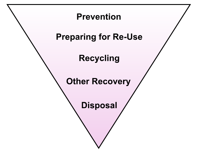
4.1.860The National Waste Strategy includes targets for reducing the amount of waste that ends up being disposed of in landfill sites. There has also been a push to move towards greater sustainability and net self-sufficiency when it comes to managing waste. Under the framework of the Environment Act 2021, the Government established legally binding commitments to halve the level of residual arisings by 31 December 2042[60] and for the near-complete elimination of biodegradable municipal waste being sent to landfill for disposal from 2028 onwards.
4.1.861The National Planning Policy for Waste (NPPW) (2014) set outs a number of key planning principles that informs Local Plan preparation and decision making on planning applications for waste development. These principles include delivering the waste hierarchy, addressing waste as a resources and disposal as the last option. The NPPW alongside the Waste Management Plan for England (2021) forms the National Waste Management Plan.
4.1.862The Waste Capacity Study (2024) estimated that a total of 862,804 tonnes of waste arose in Bradford District in 2022. This consisted of:
- Local Authority Collected Waste (LACW): 222,647 tonnes
- Commercial and Industrial Waste (C&I): 356,274 tonnes
- Construction, Demolition and Excavation Waste (CDE): 259,913 tonnes
- Hazardous Waste: 23,846 tonnes
- Agricultural Waste: 124 tonnes
4.1.863In looking over the Local Plan period, the study has projected that the volume of waste arisings in the District will increase as follows:
- Local Authority Collected Waste (LACW): 230,842 tonnes
- Commercial & Industrial Waste (C&I): 393,463 tonnes
- Construction, Demolition and Excavation Waste (CDE): 287,044 tonnes
- Hazardous Waste: 26,335 tonnes
4.1.864In 2022, 60% (419,249 tonnes) of the waste arising in Bradford District was received at facilities located within the area, with the remaining 40% (276,700 tonnes) being exported elsewhere. In terms of the former, 65% was received at transfer facilities, meaning that it was sorted and bulked up for onward transfer. Of the waste exported most was sent to landfill sites (345,533 tonnes) and treatment facilities (168,608 tonnes) in other parts of the country.
4.1.865The Waste Capacity Study (2024) includes a section on waste imports and exports, whilst a more detailed Waste Movements Paper has been prepared. The latter outlines detailed information on strategic non-hazardous and hazardous waste movements to and from the District as well as a summary of discussions with other Waste Planning Authorities.
4.1.866It is also important to make sure that new, enhanced or expanded waste facilities are in sustainable and accessible locations. The majority of the District’s existing operational/permitted waste management facilities are already located within the Regional City of Bradford and on its edge, with others in Baildon, Keighley and Shipley as well as in rural areas, for example where former mineral workings are being restored.
4.1.867Accordingly, waste development should be located in line with the wider spatial strategy of the Local Plan as well as the sequential approach outlined in the policy unless it can be clearly demonstrated that an alternative location is required. This could include considering the type of waste management facility and/or its operational requirements.
4.1.868The sequential approach seeks to reflect the proximity and self-sufficiency principles, prioritising the management of waste on-site and the co-location with existing facilities and complementary uses ahead of other locations. In line with the NPPW, the policy also recognises that existing employment and industrial areas can be appropriate for waste management development. Such areas are often located away from residential areas and may be close to where the waste is generated. However, this is provided that the design and nature of the operation is compatible with the location and surrounding land uses and does not result in unacceptable adverse effects on amenity and the wider natural and built environment.
4.1.869Other areas of previously developed land may also be suitable, subject to meeting detailed planning policy requirements, whilst sites such as active or former mineral workings may also be suitable for managing construction, demolition and excavation waste (either to provide recycled aggregates and/or as part of reclamation/restoration of former workings), subject to not impinging on the operation and/or restoration of the site. Redundant agricultural or forestry buildings and their curtilage may also be suitable for managing agricultural waste.
4.1.870Where proposals involve new, enhanced or expanded hazardous waste facilities, consideration should also be given to whether there is existing available capacity within Bradford District or the surrounding sub-region the facility is required.
4.1.871In line with the waste hierarchy, disposal (including by landfill), is the considered to be the last option. It will need to be demonstrated that the waste cannot be managed through other means and that there is insufficient capacity at existing facilities. It is recognised that there may be circumstances under which landfill sites may be allow for environmental improvements or restoration of former mineral extraction sites to take place. Should this be the case, proposals should be accompanied by a comprehensive restoration scheme.
Links
|
Strategic Objectives |
|
|
Key Policy Links |
|
|
Evidence Base |
|
POLICY WAS2: WASTE MANAGEMENT ALLOCATIONS Comment
- The following sites will continue to be allocated for waste management facilities:
|
Site Ref |
Site Location |
Site Area (ha) |
|
WAS2-1 |
Ripley Road, Bowling, Bradford |
2.35 |
|
WAS2-2 |
Aire Valley Road, Worth Village, Keighley |
2.80 |
|
WAS2-3 |
Bowling Back Lane Household Waste Collection and Recycling Site, Bradford |
4.27 |
|
WAS2-4 |
Steel Stock and Scrapholders Site, Birkshall Lane, Bradford |
4.10 |
- Any proposals for new waste management facilities on these sites will need to address the criteria set out in Policies WAS1 and WAS4, together with other relevant polices within the Local Plan.
Explanation
4.1.872The National Planning Policy for Waste requires Waste Planning Authorities to identify sites and/or areas for new or enhanced waste management facilities in appropriate locations. It provides guidance on the matters that authorities should consider when preparing Local Plans and assessing the suitability of sites and/or areas.
4.1.873As part of developing the Local Plan, a Waste Capacity Study was undertaken. This sought to identify current and future waste arisings and assess existing and future waste management capacity needs. It used a base date of 2022 and projected arisings and capacity needs through to 2041. To determine these, the study used three different recycling scenarios (Low, Central and High) for main waste types for 2022, 2031 and 2041, across the main waste streams – Local Authority Collected Waste (LACW), Commercial and Industrial Waste (C&I), Construction, Demolition and Excavation Waste, and Hazardous Waste. The study highlighted that the District had sufficient recycling capacity industrial green waste and metals.
4.1.874The Study identified that there would be a gap in the amount of waste arisings in the District and capacity at waste management facilities to manage it across all three recycling scenarios, meaning that there will be a need to identify additional waste capacity for dealing with:
- Residual LACW and C&I waste (between 179,161 tonnes and 255,534 tonnes per annum by 2041)
- Recyclable LACW and C&I waste (between 258,420 tonnes and 326,317 per annum by 2041)
- Construction, Demolition and Excavation waste (208,844 tonnes per annum by 2041)
- Hazardous waste (23,785 tonnes per annum by 2041)
4.1.875Whilst, gaps are present in current and future waste management capacity, it should be recognised that due to the nature of the waste industry, commercial decisions and availability of contracts will eventually determine whether facilities are built and what types these will be. Additionally, it must be highlighted that facilities in other Waste Planning Authority (WPA) areas will also play a role in providing capacity for managing Bradford’s waste over the Local Plan period. This is particularly the case for hazardous waste, where it may require treatment/management at specialist facilities. It is noted that Bradford has a number of transfer facilities where waste is sorted and batched before being sent elsewhere for treatment/disposal.
4.1.876Work has been undertaken to determine the quantities of waste moving between Bradford District and other areas of the country using the Environment Agency’s Waste Data and Hazardous Waste Data Interrogators, and vice versa. Such movements will be monitored on a regular basis and engagement with other WPAs will continue to take place.
4.1.877An example is the management of the Council’s residual LACW. Around 150,000 tonnes of the residual LACW are processed at a facility in Leeds (capacity 450,000 tonnes per annum) as part of a 12-year contract running until 2029 (with an option for a three-year extension). Recyclates are separated and a refused derived fuel (RDF) prepared, which is then sent to the Ferrybridge Energy from Waste facility. Similarly, the Council has a contract with a company to manage its Dry Mixed Recyclable (DMR) Waste running over a three-year period, with the option of a one-year extension[61].
4.1.878Six sites were allocated in the Waste Management DPD (2017) for future facilities. These were identified through a detailed site selection, assessment and shortlisting process. These were:
- Princeroyd Way, Ingleby Road, Listerhills, Bradford
- Ripley Road, Bowling, Bradford
- Aire Valley Road, Worth Village, Keighley
- Bowling Back Lane Household Waste Collection and Recycling Site, Bradford
- Merrydale Road, Euroway
- Steel Stock and Scrapholders Site, Birkshall Lane, Bradford
4.1.879Since 2017, two of these sites – Princeroyd Road and Merrydale Road - have been lost to other uses. Three of the remaining sites – Aire Valley Road, Bowling Back Lane and Ripley Road were also subject to planning permissions for various types of waste management facilities. However, none of these have been taken forward. Furthermore, it should be noted that the Bowling Back Lane and Steel Stock and Scrapholders sites are already in use for waste management purposes. These sites provide a total of 13.52ha of land. However, it is not possible to determine exactly how much capacity would be generated, as this would be determined by the type and nature of the facility to be provided.
4.1.880As part of developing the Local Plan (and its predecessor Allocations Development Plan Document), several Call for Sites exercises were undertaken, the most recent of which took place in May 2025. During this, a single site was put forward for a waste management facility. This site has been assessed and not considered appropriate for allocation.
4.1.881It is proposed that the four remaining site allocations, listed in the policy above, continue to be safeguarded/allocated within the Bradford District Local Plan in order to contribute to the provision of facilities to address the identified capacity gap. All sites are broadly consistent with the spatial approach to the location of waste management facilities outlined in Policy WAS1.
4.1.882In addition to the allocations listed above, the Local Plan also seeks to safeguard the District’s existing operational/permitted waste management facilities under Policy WAS3 to ensure that they continue to contribute to capacity. These facilities are listed in Appendix 7.
Links
|
Strategic Objectives |
|
|
Key Policy Links |
|
|
Evidence Base |
|
POLICY WAS3: SAFEGUARDING WASTE MANAGEMENT FACILITIES AND INFRASTRUCTURE Comment
- Existing waste management facilities and allocated sites (as listed in Appendix 7 and identified on the Policies Map) will be safeguarding from development that would prejudice or prevent the use of the site for waste management purposes.
- Proposals within or in the vicinity of an existing waste management facility or allocated waste site resulting in its loss or prejudicing or preventing its ongoing use will only be permitted, where it can be demonstrated that:
- the proposal will not prevent or unreasonably restrict the operation of the waste development
- Proposals on an existing waste management facility site or allocated waste site will only be permitted, where it can be demonstrated that:
- there is no longer any identified need for the facility or site across any form of waste arising in the District and sub-region;
- the use of the facility or site for waste management activities is proved to be obsolete or economically unviable and there is no realistic prospect of the site being used for a waste management facility;
- an alternative, suitable waste facility site is identified elsewhere in the District;
- its continued use for waste management would be unacceptable in terms of its effects on local communities and/or the environment;
- there is an over-riding need for the proposed development that provides wider benefits that clearly outweigh those from retaining the site or facility for waste management use
Explanation
4.1.883Bradford District’s network of existing waste management facilities represents a valuable part of its infrastructure and are a key resource in helping the Council to meet its international and national obligations and to deliver local waste objectives as well as managing forecast future waste arisings.
4.1.884The loss of any well-located facilities could influence the District’s ability to meet its needs for sustainable waste management. Therefore, it is important to safeguard them to ensure their continued availability and avoid capacity being unnecessarily lost. Details of the existing waste management sites/facilities that will be safeguarded are set out in Appendix 7 and identified on the Policies Map.
4.1.885The introduction of other forms of development, such as housing or business uses that need a high-quality local environment, in close proximity to waste management facilities can lead to conflict due to the potential effects on amenity arising from the operation of the facility.
4.1.886The Local Plan will safeguard existing waste management facilities and allocated waste sites within the District and resist the loss of existing facilities and allocated sites unless there is no realistic prospect of the site being used or required for waste management purposes. Particular circumstances should be demonstrated why there is a need for the loss of an existing facility, or development of an allocated waste site for another unrelated purpose.
Links
|
Strategic Objectives |
|
|
Key Policy Links |
|
|
Evidence Base |
|
POLICY WAS4: PROPOSALS FOR WASTE MANAGEMENT DEVELOPMENT Comment
- Proposals for new, enhanced or expanded waste management facilities will be supported where they:
- contribute to meeting an identified need for new waste management capacity over the plan period or can demonstrate an additional need that cannot be met by existing facilities in Bradford District or West Yorkshire;
- contribute to driving waste management up the waste hierarchy;
- demonstrate that any impacts will not significantly adversely affect communities, land, infrastructure, natural resources and the natural and built environment
- Proposals for new, enhanced or expanded waste management development will be supported where it can be demonstrated that the following impacts have been adequately addressed and any adverse effects minimised or avoided:
- The design, siting and external appearance and ensuring that it is of a scale, mass, form and character is appropriate to its location and landscape setting. It should be of high-quality design and contribute positively to the quality and character of the area within which it is located. This includes the provision of appropriate screening, boundary treatments and landscaping to mitigate any potential impacts and integrate with the surrounding area.
- Whether the facility can be fully contained within buildings or enclosed structures, unless it can be demonstrated that unacceptable environmental and other effects can be effectively mitigated and/or it genuinely requires an outdoor location.
- Local amenity including impacts on sensitive receptors and residential amenity as a result of noise, dust, lighting, vibration, vermin and birds, litter and visual intrusion.
- Surrounding land uses including ensuring proposals can be effectively integrated with existing uses and that they do not place unreasonable restrictions upon them. Where appropriate, suitable mitigation should be provided to minimise impacts.
- Impacts on biodiversity and geodiversity including designated nature conservation and geological sites, priority habitats and species, and ecological networks. Development should not lead to their long-term loss, significant deterioration or permanent disruption. This includes the South Pennine Moors Special Protection Area (SPA) and Special Area of Conservation (SAC), in particular the need to avoid and/or mitigate loss or deterioration of important foraging land within the SPA’s zone of influence. Opportunities should be considered for Biodiversity Net Gain and/or biodiversity enhancement.
- Cultural heritage and the built environment including ensuring development would not result in unacceptable harm to designated and non-designated heritage assets and known and unknown archaeological features as well as their settings. Where appropriate, a heritage statement will be required.
- Flood risk including ensuring proposals do not have an unacceptable impact on flood flows or storage capacity and not increase the risk of flooding elsewhere. Consideration should also be given to impacts on existing flood defence structures. Where appropriate, a flood risk assessment will be required.
- The water environment including water resources and the natural water environment including groundwater or water quality.
- Transport network including its capacity and suitability to accommodate additional vehicle movements, as well as mitigation of any adverse impacts on users. Consideration should also be given to reducing the need to travel including investigating the potential of transporting waste by non-road transport modes, where appropriate.
- Climate change including how proposals will impact on climate change and targets to reduce greenhouse gas emissions, as well as adaptation and mitigation measures, where appropriate.
- Ensuring that the facility’s design, layout and construction meets environmental construction standards of BREEAM ‘very good’ to 2024 at a minimum and comply with Future Buildings Standard.
- Ensuring that the facility’s design, location, and operation maximise opportunities to recover energy and to make efficient use of heat and water resources.
- Ensuring that it can be demonstrated that emissions from waste treatment and HGV movements can be mitigated including the consideration of cleaner fuels and technologies capable of reducing emissions.
- Operation of the facility including hours of operations, traffic movements, vehicle cleansing and loading/unloading arrangements.
- Potential to give rise to unacceptable adverse cumulative effects arising from waste management facilities in a particular location.
- Ensuring, where appropriate, that details of a high quality and progressive restoration to a suitable after use or activity following the cessation of the waste management operation is provided.
Explanation
4.1.887Waste management facilities can have an impact on local communities and the wider environment. Therefore, it is essential that facilities are sited in the most appropriate locations and that due consideration is given to managing the impacts of waste management developments on the District’s communities, land, natural resources and the natural and built environment.
4.1.888This policy builds on the wider strategic approach established in Policy WAS1, by providing more detailed policy guidance for developers and communities on where potential facilities may be acceptable and addressing the impacts that may arise from waste management developments.
4.1.889Accordingly, planning applications should include an appropriate level of detail setting out how they would address the criteria in this policy. This may entail submitted several supporting statements and/or documents, details of which are set out in the Council’s Validation Checklist for Major Planning Applications including that for waste developments[62].
4.1.890Examples of these supporting statements and/or documents could include*:
- Air Quality Assessment
- Contaminated Land Assessment
- Ecological Assessment
- Flood Risk Assessment
- Heritage Statement
- Landscape and Visual Impact Assessment
- Transport Statement
4.1.891*The above list is not exhaustive and will be dependent on the nature and location of the proposed waste development.
4.1.892Planning conditions and, where necessary, legal agreements will be used, where appropriate, to ensure that mitigation measures are put in place to address any potential effects.
4.1.893Developers are strongly encouraged to engage with the Council at an early stage in preparing their proposals to establish what supporting information is likely to be required as an important element of applying for permission for waste development. Similarly, consultation with local communities is encouraged at early stages in line with Council’s Statement of Community Involvement.
4.1.894Engagement with the Environment Agency and other key bodies is also encouraged, as many facilities will involve the need for an Environmental Permit or may be subject to other regulatory regimes. The planning system is required to assume that such regimes will operate effectively.
Links
|
Strategic Objectives |
|
|
Key Policy Links |
|
|
Evidence Base |
POLICY WAS5: WASTE MANAGEMENT WITHIN DEVELOPMENT Comment
- Proposals for all new development should have regard to the principals of sustainable construction and design, the need to reduce the use of resources and address climate change. This includes demonstrating how waste and its management will be addressed as part of its design, construction and operation.
- Proposals will be supported where it is demonstrated that:
- it makes use of recycled and secondary materials during construction of the development, including minimising the level of waste resulting from it;
- appropriate management arrangements are made to deal with the waste arisings generated by the development as part of its operation. This includes measures to reduce the level of waste generated, ensuring opportunities are provided for waste recovery and recycling to take place on-site and that the need to dispose of waste is minimised;
- opportunities have been explored for the on-site generation of electricity or use of heat from the recovery and treatment of waste, as part of creating energy efficient designs and supporting the use of renewable and low carbon energy source;
- that waste to be managed/treated cannot practically and reasonably be reused, recycled or processed to recover materials;
- the design maximises opportunities for the recovery and recycling of materials at the end of the development’s life
- Where demolition needs to take place before construction, as far as possible, construction and demolition waste should be recovered or recycled, preferably on-site. The impacts of any proposed on-site management of construction and demolition waste should be minimised in terms of amenity, climate change, human health and pollution.
- Proposals for all development must ensure that provision is made for facilities for the sorting, storing and collection of waste and recycling. This includes:
- sufficient space for storing and collecting individual or communal recycling and refuse containers. Provision should be well-integrated into the design of the development to ensure that impacts on the health and amenity of the community and the wider environment are reduced;
- ensuring safe and convenient access for existing users/occupants and providing and maintaining appropriate access for refuse and recycling collection vehicles
- Where appropriate, consideration should be given to the incorporation of neighbourhood waste management, treatment and collection facilities within larger scale developments.
Explanation
4.1.895All development has the potential to generate significant quantities of waste, particularly during the construction, operation and demolition phases. Waste management issues, therefore, need to be addressed at the design stage of developments as well as in determining planning applications to ensure that any waste arising is managed in a sustainable manner, and in line with the Waste Hierarchy. This includes, in line with national policy and guidance, ensuring that new development makes sufficient provision for waste management that meets its needs and the type and quantity waste that will be produced
4.1.896There are also strong links to the wider principles of sustainable design and construction as well as making efficient of use or reducing the use of resources and contributing towards tackling climate change (as set out in Policy ST3). Such principles must be taken into consideration for all new development in the District.
4.1.897The policy, together with others within the Local Plan, seeks to promote good management of waste within all new developments including:
- minimising and/or reducing in the level of waste produced during construction and operation,
- supporting, where appropriate, the on-site management of waste including opportunities for recovery and recycling.
- supporting sustainable construction and design practices including the use of recycled and secondary materials, recovery/re-reuse/recycling of on-site material, measures to support energy and water efficiency and contribute towards climate change mitigation and priorities.
- provision of facilities for the storage and regular collection of waste.
4.1.898In relation to the on-site reuse and recovery of Construction, Demolition and Excavation (CDE) Waste developers should be mindful of environmental management regulations and best practice governing this to ensure it does not cause undue nuisance to surrounding communities.
4.1.899In terms of making sufficient provision for waste management within new (non-waste) development, it is important that this is considered and integrated at the earliest stages in the design process. This will ensure there are no adverse impact on the wider development and surrounding environment.
4.1.900New developments will need to incorporate opportunities on-site that allows occupiers and users to separate and store waste for recycling and recovery as well as collection. The exact nature will vary between different types of development and location. For residential development, provision should be made for storing bins, as part of ensuring that a high quality, comprehensive and frequent waste collection service can take place. Bin and recycling container storage areas should be well designed and integrated into the wider built environment.
4.1.901Smaller development sites could potentially include the provision of collection points for segregated waste. On larger sites, particularly where significant areas of new housing or employment land are proposed, waste storage facilities will almost always be needed and provision might also include on-site treatment/management facilities or, in the case of industrial operations, the management of specific wastes produced on site. The scale and type of any facilities will vary depending on the development.
4.1.902There may be opportunities, particularly for larger scale developments, for the incorporation of small-scale waste treatment and processing facilities into the scheme, particularly where there is scope for the recovery and use of electricity and heat, as part of creating energy efficient designs and support the use of renewable and low carbon energy sources
4.1.903The Environment Act 2021 sets out the required arrangements local authorities must provide regarding the separate collection of household waste. Unless exceptional circumstances apply with regards to collections, recyclable household waste must be collected separately from other household waste. This legislation also applies to commercial properties and requires these premises to separate recyclable waste from “relevant waste”, i.e. general waste sent to landfill. Recyclable waste includes glass, metal, plastic, paper/card, food waste and garden waste.
4.1.904Residents in Bradford District are provided with 1 x 240 litre general waste (Green) bin and 1 x 240 litre recycling waste (Blue) bin. There is also an option for residents to have a garden waste (Brown) bin. It is an optional service for which there is a charge to have the bin emptied. From autumn 2026, food waste collection will be rolled out to households across the District. This is in line with the Government’s Simpler Recycling legislation. Each household will receive a small kitchen caddy with liners and an outdoor food waste bin.
4.1.905Under the Environmental Protection Act 1990, businesses have a duty of care to keep their waste safe and for the disposal of all their recyclable materials and commercial waste. For business, the Council, as a licensed waste carrier, offers a paid for “trade waste” collection service. Four sizes of wheeled bins are offered (240 litre, 360 litre, 660 litre and 1,100 litre), which are collected on weekly or fortnightly basis. Other commercial companies also offer similar services.
4.1.906Provision should be made within the layouts of new development for refuse and recycling vehicles to access them to allow collections to take place. The ADEPT report "Making Space for Waste" sets out specifications for the minimum standards for the type, and scale of facilities and vehicular manoeuvrability needed for new residential, commercial and mixed-use developments. It may be appropriate to include a refuse management strategy as part of the information submitted alongside planning applications. Requirements for waste storage and possible locations for waste collection are set out in Part 6H The Building Regulations (2010) (as amended in 2015).
4.1.907Discussions should take place with the Council’s Waste Management and Highways services regarding collection arrangements in new development. Further guidance on incorporating waste storage, recycling and collection into new residential development is set out in the Council’s Homes and Neighbourhoods Design Guide Supplementary Planning Document (2020).
4.1.908Large scale developments should be accompanied by a Site Waste Management Plan (SWMP). Such plans can be an effective tool in ensuring the development proposals are sustainable in waste management context. They help developers to show how good waste management practices have been integrated into the design of development. Other approaches may be to include a Construction Environmental Management Plan (CEMP) as part of any planning application.
4.1.909It should be noted that information to accompany planning applications to demonstrate compliance with the policy should be proportionate to the size of the development and the amounts and types of waste likely to be generated.
Links
|
Strategic Objectives |
|
|
Key Policy Links |
|
|
Evidence Base |
[1] Letwin Review - https://www.gov.uk/government/publications/independent-review-of-build-out-final-report and Lichfields Insight March 2024: Start to Finish
[2] https://www.gov.uk/guidance/connectivity-tool
[3] NB: The SHMA did not estimate long term housing needs broken down by tenure or size mix.
[4] Also commonly referred as large scale purpose built shared living.
[5] A habitable room is defined as any room used or intended to be used for sleeping, cooking, living or eating purposes. Enclosed spaces such as bath or toilet facilities, corridors, hallways, utility rooms or similar should not be considered habitable rooms. Habitable floorspace is defined as all floorspace with a floor to ceiling height of 1.5m or over within a habitable room. Floorspace within habitable rooms with a floor to ceiling height of between 0.9m and 1.5m is counted as 50 per cent of its floor area and any floor area with a floor to ceiling height lower than 0.9m is not counted as habitable floorspace.
[6] https://www.bradford.gov.uk/planning-and-building-control/planning-policy/community-infrastructure-levy/
[7] Available at https://www.bradfordcft.org.uk/wp-content/uploads/2026/03/BCFT-Sufficiency-Strategy-2025-2028.pdf
[8] The above provides a summary of HMOs and the full legal definitions should be referred to as appropriate, as set out in the Town and Country Planning (Use Classes) Order 1987 (as amended). There are separate definitions in respect of the licencing of HMOs as set out in the Housing Act 2004 and related secondary legislation.
[9]Applicant should refer to the HMO standards in the link below or any subsequent equivalents to this. https://www.bradford.gov.uk/media/6846/amenitystandardsforhousesinmultipleoccupation.pdf
[10] Employment Land Review (2024) Edge Economics and Employment Land Review Addendum (2026) Edge Economics
[11] Built Different, Bradford 2025-2035
[12] West Yorkshire Freight Study, West Yorkshire Transport Evidence Base, Chapter 6 – Freight.
[13] National Planning Policy Framework (NPPF) (December 2024) – Paragraph 98
[14] Planning Aid England Website – Assets of Community Value and their relationship to planning -https://www.planningaid.co.uk/hc/en-us/articles/360009936577-Assets-of-Community-Value-and-their-relationship-to-planning
[15] Environment Agency (April 2026), Protecting Groundwater from Human Burials - https://www.gov.uk/government/publications/protecting-groundwater-from-human-burials/protecting-groundwater-from-human-burials
[16] Department of Health and Social Care (2026) – Policy Paper: Neighbourhood Health Framework - https://www.gov.uk/government/publications/neighbourhood-health-framework/neighbourhood-health-framework#neighbourhood-health-estates-and-locations
[17] Department of Health and Social Care (2026) – Policy Paper: Neighbourhood Health Framework - https://www.gov.uk/government/publications/neighbourhood-health-framework/neighbourhood-health-framework#neighbourhood-health-estates-and-locations
[18] Bradford District and Craven Health and Care Partnership (2026) – An Introduction to Integrated Neighbourhood Health (Slide Deck) - https://bdcpartnership.co.uk/wp-content/uploads/2026/01/An-introduction-to-INH-in-BDC.pdf
[19] https://www.bradfordhospitals.nhs.uk/bradford-delivering-world-leading-results-in-getting-children-active/#_ftnref2
[20] CBMDC ‘Our Plan for Bradford District’ (2021-25)
[21] https://www.activebradford.com/our-strategy
[22] https://www.yorkshiresport.org/
[23] West Yorkshire Low Emissions Strategy or any successor documents
[24] The air quality limit values set by the EU Ambient Air Quality Directive were implemented in UK law through the Air Quality Standards Regulations 2010 and have been retained in domestic legislation following Brexit.
[26] Including the DEFRA safeguarding soils strategy and Construction Code of Practice for the Sustainable Use of Soils on Construction Sites.
[27] The Council has developed a Developer Sustainability Checklist (Appendix 10) to help applicants comply with the requirements of Policy ST3 and this policy to ensure climate impacts are considered at an early stage in scheme design.
[28] Those developments required to connect to a heat network will be defined in the forthcoming regulations. Guidance suggests these may include: new buildings, existing communally heated buildings and some existing non-domestic, non-communally heated buildings.
[29] Residential developments of 10 dwellings or more, non-residential floorspace of 1,000m2.
[30] Bradford District Level 1 Strategic Flood Risk Assessment (SFRA) (2023) or any successor document.
[31] Flood Zones 2 and 3 are nationally defined datasets. Flood Zone 2 is a 1 in 1,000 year fluvial flood event (0.1% Annual Event Probability (AEP)). Flood Zone 3 is a 1 in 100 year fluvial flood event (1% AEP). Flood Zone 3a is the part of Flood Zone 3 which is not classed as functional floodplain (Flood Zone 3b) i.e. land where water from rivers or the sea has to flow or be stored in times of flood.
[32] Bradford District Level 1 Strategic Flood Risk Assessment (SFRA) (2023) or any successor document.
[33]Urban Greening Factor for England User Guide, Natural England (2023) as updated or superseded
[34] The North Pennine Moors SPA/SAC is located outside of the District boundary, but development within the District may have an impact on this Habitats Site. Policy NE3 will also be applicable to development proposals affecting the North Pennine Moors SPA/SAC.
[35] The National Site Network is the UK‑wide network of protected sites made up of all existing Special Areas of Conservation and Special Protection Areas designated under the Nature Directives, along with any additional sites designated under the post‑EU Habitats Regulations.
[36] Biodiversity net gain. Good practice principles for development. Baker, J., Hoskin, R., Butterworth, T.
[37] This means within or adjacent to the settlement that the proposal is located within.
[38]In line with government guidance, in Bradford ‘significant’ on site biodiversity provision means any site with Medium, High or Very High Distinctiveness habitats. It also means any on site provision of habitats providing three or more biodiversity units of any habitat type. This includes created, enhanced and retained habitats.
[39] In line with government guidance, in Bradford district, ‘significant’ on-site biodiversity provision means any site with Medium, High or Very High Distinctiveness habitats. It also means any on-site provision of habitats providing three or more biodiversity units of any habitat type. This includes created, enhanced and retained habitats.
[40] https://www.gov.uk/guidance/ancient-woodland-ancient-trees-and-veteran-trees-advice-for-making-planning-decisions
[41] British Standard BS 5837: 2012: Trees in relation to design, demolition and construction (or any successors)
[42] The provision of tree lined streets and fruit trees does not count towards the 3:1 ratio for on-site replacement tree planting requirements.
[43] Further information on this can be found in the Green and Blue Infrastructure Policy NE1.
[45] As set out in the Bradford District Green and Blue Infrastructure Study.
[46] Saltaire World Heritage Site Management Plan (2014) or any successor documents.
[47] Where proposals for recycled and secondary aggregate processing facilities are situated within operational mineral extraction sites, they should not prohibit its future restoration when extraction ceases.
[48] National Planning Policy Framework (NPPF) (December 2024) – Paragraphs 223 and 226
[49] West Yorkshire Local Aggregate Assessment 2026 (2024 data), West Yorkshire Combined Authority & West Yorkshire Mineral Planning Authorities
[50] As of 31st December 2024
[51] West Yorkshire Local Aggregate Assessment 2026 (2024 data), West Yorkshire Combined Authority & West Yorkshire Mineral Planning Authorities
[52] As of 31st December 2024
[53] West Yorkshire Local Aggregate Assessment 2026 (2024 data) – Section 3.2
[54] Mineral Safeguarding in England – Good Practice Advice (BGS, 2011
[55] Due to its location with the urban area, a buffer zone applies to Bolton Woods Quarry. It is shown on the Policies Map.
[56] Planning Practice Guidance – Minerals: Restoration and Aftercare of Minerals – Paragraph 040 Reference ID: 27-040-20140306.
[59] The EU Waste Framework Directive was transposed into UK law via Waste (England and Wales) Regulations 2011.
[60] The Environmental Targets (Residual Waste) (England) Regulations 2023 – Regulation 2
[61] Letsrecycle.com website (29.06.2026) - DSM rebrands as MATIQ and secures Bradford recycling contract - https://www.letsrecycle.com/news/dsm-rebrands-as-matiq-and-secures-bradford-recycling-contract/ (Accessed 09.09.2026)
[62] Available to view on the Council’s website at https://www.bradford.gov.uk/planning-and-building-control/national-and-local-validation-requirements/local-requirements-waste-development/. This information would in addition to the National and Local Information Requirements for planning applications.
