

Bradford District Local Plan - Publication Draft (Regulation 19) (October 2026)
Nufarm South
The vision for the site is to provide a new strategic employment site which allows for further investment in the Nufarm plant and the delivery of new employment land at scale to help meet forecast needs.
The site is located within very close proximity to the M62 and M606 motorways, with access less than 1 mile from Junction 26 of the M62. This provides a unique opportunity within the district to develop a prime location site with access to major transport corridors, which will be attractive to a wide range of business operations including logistics and distribution.
Nufarm also presents opportunities to deliver high-quality design, strategic landscaping, biodiversity net gain benefits and integrated sustainable energy infrastructure as part of a more holistic vision for the site.
E157 NUFARM SOUTH STRATEGIC EMPLOYMENT SITE Comment
Site Boundary
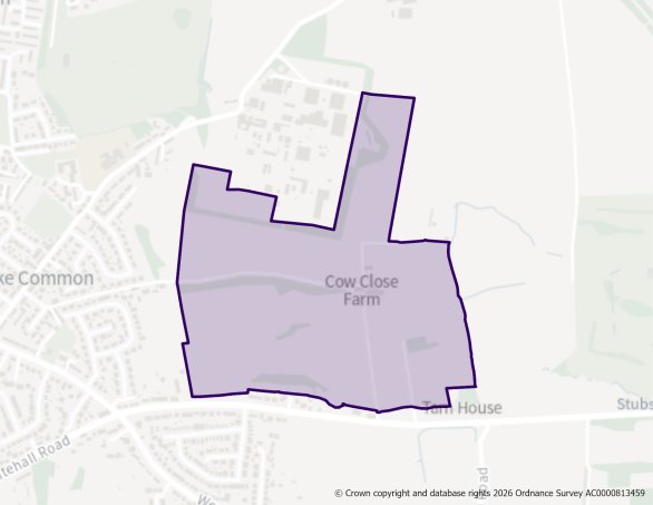
Site Size (ha) Gross: 40.03
Net Developable Area (ha): 22.12
Proposed Land Use: Employment (Eg(i), B2 and B8)
Site Type: Greenfield
Ward: Wyke
Settlement: Bradford South-East
Ownership: Private
Delivery Timescale: 2030-2043
Site Specific Requirements
Quantum of Development
- Land at Nufarm South as shown on the Policies Map is allocated for a new Strategic Employment Site to deliver approximately 22.12 ha (net) of employment land for employment generating uses in use class E(g), B2, B8 and other suitable sui generis employment generating uses where they are compatible with the overall function of the site.
- Development of employment units and any subsequent change of uses within the COMAH Inner Zone will only be acceptable if they are less than three storeys in height and contain less than 100 occupants per unit.
- Development of employment units and any subsequent change of uses within the COMAH middle and outer Zone will only be acceptable in accordance with HSE advice based on the sensitivity level of the development and the zone it falls within or straddles as agreed in consultation with HSE.
- No buildings should be located on the combined inner / middle high pressure gas pipeline zone and there must be sufficient buffer in place as agreed in consultation with HSE and have regard to pipeline operator constraints.
- There should be a detailed risk assessment to accompany any planning application as to the cumulative impact of likely development within the hazard zones, to include:
- Development option analysis as part of masterplanning.
- Hazard management and controls.
- Infrastructure and procures in the event of an evacuation.
- Effective monitoring procedures in terms of occupancy levels and business operations.
Design Process and Quality
- Any planning application should include an illustrative masterplan and phasing schedule with supporting parameter plans to allow for a comprehensive and coordinated approach to development, which demonstrates how the parameters and the quantum of development being applied for can be effectively accommodated on the site.
- Parameter Plans set out the design parameters for future reserved matters stages to adhere to, and should include:
- Land uses and layout
- Landscape, green infrastructure and open spaces
- Ecology and habitat framework
- Movement framework/ access/connections
- Heritage features and character areas
- Building heights
- Retained features
- Views/landmarks/focal points/building lines etc
- Development and site layout should respond positively to the site’s prominent location and proximity to housing through high-quality design, layout and structural landscaping to minimise impact on residential amenity.
- Development should maximise the integration of renewable energy infrastructure, including rooftop solar through reinforced roofs and associated electricity infrastructure to offset regulated energy consumption. Heat pumps should allow for dual heating and cooling functions in line Policy CR3.
- The delivery of infrastructure to support sustainable energy generation on non-operational land is supported.
- Measures should be in place to secure appropriate levels of electric vehicle (EV) charging and multifuel hubs to support the wider transition of businesses to a low carbon freight and logistics operational environment with supporting infrastructure for business occupiers and visitors.
Site Access and Traffic Impacts
- The principal vehicular access would be taken from the eastern end of the frontage on the A58 via either traffic signals or a roundabout, with an internal spine road providing access to all new and existing units and pedestrian/cycle access retained to Cow Close Cottages.
- A second emergency only vehicular access and active travel corridor to be taken from the western frontage of the A58, with a connection to the internal spine road.
- The access points, where the new roads join the A58, are in Kirklees District. The layout of the internal road network and its connections to the A58 will need to allow for bus services to travel through the development rather than serve it as a dog-leg.
- Improvements to the junctions of the A58 with Westfield Road and Branch Road, and the junction of Bradford Road and Chain Bar Interchange (M62 J.26) will be required to mitigate the impact of development as set out through the Council’s cumulative traffic modelling.
Active Travel
- Provide safe and convenient pedestrian and cycle infrastructure within the site and with connections to the wider network, including Knowle Lane and Wyke Lane, and active travel provision along Wyke Lane between Spen Valley Greenway and Wyke.
- Footways on the roads within the site to meet requirements of Inclusive Mobility and cycling provision on internal roads to meet LTN1/20 requirements with measures undertaken to ensure connectivity through the site and upgrades to existing paths connecting the development to established cycling and walking networks, including traffic free routes.
- Retaining, diverting and upgrading the public right of way along the eastern boundary PROW Bradford South 21 and 33 to a muti-use route for pedestrians and cyclists and creating a new footpath from Cow Close Lane to Wyke Lane, connecting onwards to Upper Wyke via Wilson Road, which is unadopted and will need to be brought up to standard.
- Connections also available from the site via upgraded and new pedestrian and cycle routes. Safe and secure pedestrian and cycling routes should also be provided to Low Moor railway station.
Public Transport
- Bus infrastructure should be provided along the spine road corridor, consisting of bus stops with clearways and shelters. A plan for servicing the site by bus will need to be agreed with Bradford Council and WYCA. Consideration will need to be given to a new bus service to the development serving appropriate local destinations, or to enhancing and diverting the existing services, with a priority to connect to Low Moor Station.
- Connections also available from the site via upgraded including and new pedestrian and cycle routes. Safe and secure pedestrian and cycling routes should also be provided to Low Moor railway station.
- Travel Plan
- Implementation of a travel plan with a comprehensive package of measures can be designed and implemented to maximise the awareness of sustainable travel options and to reduce the reliance of employees upon single occupancy private car use.
Environmental Protection
- To address surface water flooding, flooding arising from fluvial sources and run off from new development there is a need to deliver a comprehensive sustainable urban drainage system which forms an integral part of the site design, landscaping and open space features.
- Site is within/partially within a Development High Risk Area for coal mining, indicating that it contains one or more recorded former related features at surface or shallow depth. A Coal Mining Risk Assessment (CMRA) will be required as part of any planning application.
- Site is within a Mineral Safeguarding Area (MSA) for coal. A mineral resource assessment will be required as part of any planning application to determine the extent and availability of any coal resource.
- The site is partly crossed by overhead or underground high voltage electricity transmission lines/cables and sufficient mitigation measures should be in place to alleviate any associated risks.
Natural and Historic Environment
- Based upon habitats present and likely presence of protected and notable species a full ecology assessment and surveys should be undertaken as part of any planning application with appropriate mitigation measures applied within an agreed habitat framework.
- Biodiversity Net Gain requirements are set out in Policy NE5 with strategic scale sites encouraged to exceed the statutory minimum requirement.
- The statutory listed (grade 2) Cow Close Cottages former farmhouse is a prominent feature on the site and development should avoid causing unacceptable harm to the setting of the heritage asset through the siting of buildings and associated infrastructure.
Open Space and Green / Blue Infrastructure
- Provide appropriate landscape buffers to the stream corridor, existing tree belts and site boundaries, including new hedgerow planting along the southern boundary and within the site to mitigate visual impacts.
- Retain and enhance existing trees, and hedgerows along site boundaries and stream corridor, together with the creation of new woodland areas.
- The retention and creation of ponds on site, and retention of wet ditches and watercourses in the site to provide suitable habitats for amphibians and would add visual and amenity interest for users.
Landscape
- Commercial development on this site will contrast with the nearby residential properties and wider suburban type residential development and would need substantive screening to integrate. The existing woodland screening around the periphery of the site should be retained and enhanced, as should the route and associated vegetation of Stubbs Beck.
- Sensitivity is higher in the north-east corner due to the presence of the Grade II Listed farmhouse. To mitigate the impacts on this and on walkers on the long-distance footpaths to the east, consideration should be given to incorporating a buffer within the eastern section of the site to minimise impacts on views from the PRoW. Further buffers would be needed to protect views from residential areas to the west and south. The sense of arrival into Wyke along the A58 would also need to be considered.
Green Belt
- Site has been removed from the Green Belt and development of the site should be consistent with the framework.
- Strengthen Green Belt permanence through new landscape features and substantial planting including woodland, with supporting vegetation to the east to provide a new defensible Green Belt Boundary and a belt of woodland and wood pasture between the residential properties to the west and units to the east to diversify habitat types and provide a filtering of views from the nearby housing.
Infrastructure and Delivery Requirements
- The development of the site will be subject to a detailed package of infrastructure measures to mitigate the impact of the scheme and deliver sustainable development, which will include financial contributions in line with Policy ID1.
Evidence
- Employment Needs Assessment Update (2026)
- Bradford District Transport Assessment (2026)
- Landscape Character SPD (2026)
- Heritage Impact Assessment
