

Bradford District Local Plan - Publication Draft (Regulation 19) (October 2026)
Policy BNE1: Bradford North East
Introduction
The Local Plan settlement hierarchy identifies Bradford North East as one of four quadrant areas within the wider Regional City of Bradford. It is broadly defined by Leeds Road to the south and Canal Road area to the west, extending northwards to Thackley woods and the Leeds Liverpool Canal and the District boundary with Leeds to the east. It covers an area of 1,650 hectares and is primarily residential in character with strong commuter and access connections to Bradford and Leeds City Centres.
Bradford North East includes the wards of Idle and Thackley, the southern part of Windhill and Wrose, Eccleshill, Bolton and Undercliffe (east of Wapping Road), Bowling and Barkerend and Bradford Moor. The Canal Road Corridor (CRC) is located along the western border of this sub area, stretching north from the city centre to Shipley alongside Canal Road and falls mainly within the Windhill and Wrose and Bolton and Undercliffe Wards.
This sub-area can be characterised as densely developed and populated urban environment with the main employment areas located to the east of the Shipley Airedale Road and south of Barkerend Road and at Gain Lane where Morrisons have their headquarters. There are also pockets of employment development, most notably in Idle and Greengates.
Traditionally a mixed employment area, the CRC developed out of its proximity to the Bradford Canal and the railway line forming a gateway route northward into and out of the city into Airedale and beyond. The area is today characterised by a range of uses. The central area around Bolton Woods has a variety of uses including existing residential communities and areas of longstanding business and employment. To the south, the area has a predominance of retail, business and commercial uses, which link to Forster Square retail area.
The Council’s previous/ongoing regeneration ambitions for the area include continuing the delivery of the Canal Road Urban Village New Bolton Woods Masterplan Site. Initial phases of development of this site have been delivered over recent years, including new homes and supporting retail units.
The CRC is also identified by the Local Enterprise Partnership as a Spatial Priory Area (SPA) Investment Location– an area where future housing and employment development should be encouraged.
Bradford North East also covers Leeds Road Corridor strategic regeneration area- a key intercity transport corridor with opportunities for physical transformation providing space for retail, commercial, business and residential uses with improved public transport integration. The corridor is distinctive in character, with diverse uses and a strong specialist ethnic retail presence. With the right balance of policy support and delivery mechanism the Council believe the area possesses opportunities to reposition itself as a key growth and investment destination.
Vision
Bradford North East will help deliver a holistic vision for the future of the Regional City as a culturally diverse, liveable and vibrant area which maximises opportunities for improved connectivity, place-making and support for new homes, jobs, business growth and local services and facilities.
POLICY BNE1: BRADFORD NORTH EAST Comment
Settlement Plan
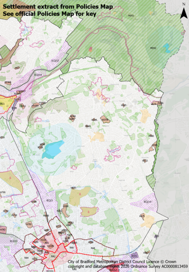
Settlement Hierarchy and Spatial Directions
- Bradford North East is defined on the policies map and forms part of the Regional City which will support modest additional housing growth in sustainable locations supported by existing local services and improvement to infrastructure provision and environment.
- Housing growth will primarily be focused upon maximising opportunities for the reuse of brownfield sites and sensitive development on urban greenfield sites for new housing within the settlement boundary.
- Broaden the diversity, tenure and quality of housing within the area with opportunities to attract new residents benefiting from rail and bus connectivity, enhanced community facilities, improved environmental quality and access to employment.
- A range of housing types will be encouraged to provide a range of unit sizes, including mid to-high density apartment buildings and mid to-lower density townhouse terraces, together with the conversion of existing buildings including residential uses within the upper level of commercial buildings.
- Continue to support local businesses and economic sector specialisms including advanced manufacturing, engineering and professional services.
Meeting Growth Needs
- Housing development in Bradford North East will deliver approximately 2,407 dwellings through a combination of sites within the urban area and land released from the Green Belt from sites under construction, with planning permission and new site allocations during the plan period as set out in Table BNE1.1
Table BNE1.1 - Bradford North East
|
Under Construction |
Planning Permission |
Site Allocations |
|
|
Totals |
1,358 |
185 |
864 |
- Deliver housing site allocations as shown on the policies map and within the proformas in section 5. Proposals for new homes within the settlement boundary on additional small sites, including the redevelopment of previously developed land, will also be supported subject to meeting policies HO3 and DS3.
- Market-led approach to delivery of development on housing site allocations – working with developers and registered providers to secure quality housing schemes.
- Employment uses will continue to be concentrated within Apperley Bridge/Esholt (Former Filter Beds- Waste Water Treatment Works) area. Good public transport links with Bradford and other Regional Cities and Towns provide the opportunity to access a wider range of employment prospects.
Local Services and Facilities
- Support a positive approach to maintaining the vitality of the designated District and Local centres, as defined on the Policies Map, through enhancing their diverse range of retail, service and leisure uses, and supporting the retention and improvement of other local services and facilities.
- Protect and enhance designated Local Green Spaces and open spaces in compliance with Policy EN2 and support proposals which address deficiencies in open space provision as set out on the Open Spaces Study.
- Maintain and enhance sport and recreation facilities with support for widened community access.
Landscape
- Maintain and enhance the landscape setting, landscape features, fields and overall settlement pattern.
Historic and Natural Environment
- Protect and enhance strategic green and blue networks and corridors including the Leeds-Liverpool Canal and urban fringe to enhance biodiversity and recreation within and adjacent to the settlement as well as incorporating sufficient green space and connections within new developments.
- Protect and enhance the designated Local Wildlife Sites and Local Geological Sites as well as habitat networks and priority habitats within and adjacent to the settlement. Development proposals should also pay particular attention to avoiding impact on the Trench Meadows Site of Special Scientific Interest towards the north-west of the settlement.
- Where development is located within SPA/SAC Zone C (Recreational Pressure) residential development resulting in a net increase in dwellings will be required to mitigate any recreational pressure on the SPA/SAC caused by such development in accordance with the South Pennine Moors SPD and Policy EN3.
- Ensure that future development conserves and enhances key heritage assets and their settings within and adjacent to the settlement including the four Conservation Areas and Listed Buildings as well as non-designated heritage assets.
- Development on the north-western edge of the settlement within the Saltaire World Heritage Site (WHS) Buffer Zone should comply with Policy HE1 and conserve those elements which contribute towards its Outstanding Universal Value (OUV), including its setting and key views.
Local Infrastructure
- Support improvements and access to public transport and active travel connections within and beyond Bradford North East, including along the A650 corridor between Five Lane Ends Roundabout, Enterprise 5 Retail Park and Bradford City Centre via Kings Road and Canal Road in order to improve bus reliability, encourage active travel, support inclusive growth, improve safety, and contribute towards net zero and Vision Zero objectives.
- The implementation of the West Yorkshire Transport Plan will secure a high-quality public transport network for the Regional City including Bradford North East, along with a comprehensive and attractive network for walking, wheeling and cycling, including secure cycle parking, to improve the environment for residents, businesses and visitors.
- Support the provision and improvement of community infrastructure required to meet the needs arising from growth, including refurbishment, major modernisation and/or replacement of Eccleshill Swimming Pool and substantial programme of lifecycle investment across sports halls, education, health and fitness facilities to address ageing infrastructure, maintain service quality and reduce future maintenance liabilities.
- Proportionate contributions towards improvements in community infrastructure, including consideration of additional education, healthcare and recreation provision as a result of an increased residential population.
- Protecting an alignment for proposed re-introduction of the Bradford Canal to enable its future provision.
Evidence
- Settlement Study (2026)
- Landscape Character Assessment SPD (2026)
- South Pennine Moors SPD (2022)
- Transport Assessment (2026)
- Sports Assessment (2026)
- Retail and Leisure Study (2026)
- Local Infrastructure Plan (LIP)
- Integrated Sports Assessment (2026)
Bradford North East: Site Allocations
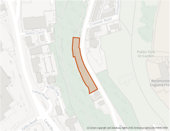
Site Size (ha) Gross: 0.31
Proposed Land Use: Housing
Minimum Development Capacity (Dwellings): 16
Site Type: Greenfield
Ward: Bolton & Undercliffe
Settlement: Bradford North East
Ownership: Mixed
Delivery Timescale: Long 2035+ (11+)
Site Specific Requirements
Design Principles
- Development should provide at least 16 dwellings as part of a high-quality built environment in line with Policies ST4 and DS1, at a net density of 50 dph in line with Policy HO2. This should include affordable housing (in line with Policy HO4) and an appropriate mix of dwellings (in line with Policy HO3 and having due regard to relevant housing needs, evidence and the character of the area).
- The site is narrow therefore site design should ensure that the layout accommodates sufficient width to facilitate safe vehicle usage as well as footways etc.
Site Access, Highways and Transport
- New access is required to connect to Bolton road, which has footways and streetlighting present.
Flooding, Water and Drainage
- Development should be possible at this site given the low fluvial and very low surface water flood risk to the site.
- Given the change in use and therefore vulnerability of the site, Flood Risk Assessment (FRA) must show that the development can be designed to be safe and that there is adequate emergency planning provision.
- Safe access and escape routes may be challenging to achieve in the low risk surface water event therefore must be considered further at the site-specific FRA stage.
Natural and Historic Environment
- Adjacent to Local Wildflife Site (LWS) (Boars Wells Urban Wildlife Reserve). Contributory landscaping/new tree planting will mitigate against any impact from the development.
- The site is located within a bat alert area. An ecological survey will be required as part of any planning application to establish the extent/impacts as well as to identify appropriate mitigation.
Environmental Protection
- This site is located within the Clean Air Zone and development must be in accordance with the requirements set out in Policy CR1.
- Site is within 150m buffer of a former landfill site. A Land Contamination Assessment – Phase 1 Report will be required as part of any planning application.
- Site is within/partially within a Development High Risk Area for coal mining, indicating that it contains one or more recorded former related features at surface or shallow depth. A Coal Mining Risk Assessment (CMRA) will be required as part of any planning application.
Open Space and Green / Blue Infrastructure
- Site is designated open space (OSA: Natural and semi natural greenspace) but loss would not result in a deficiency / exacerbate an existing deficiency for this typology and the area overall. Open space should be provided in line with Policy NE2, having regard to the standards set out in Appendix 11.
- The site lies within the Bradford City Centre Opportunity Area, as identified in the Green and Blue Infrastructure Strategy (GBIS). The strategy should be consulted to identify opportunities for incorporating measures within the development that enhance the quality of, and connectivity to, the green and blue infrastructure network in this area.
Infrastructure Requirements
- Proportionate contributions to community infrastructure will be required, where appropriate, in line with Policies ID1 and ID2, and having regard to the Local Infrastructure Plan (LIP).
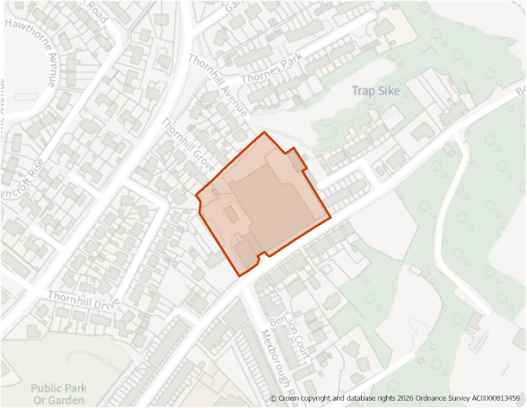
Site Size (ha) Gross: 0.83
Proposed Land Use: Housing
Minimum Development Capacity (Dwellings): 30
Site Type: PDL
Ward: Windhill & Wrose
Settlement: Bradford North East
Ownership: Private
Delivery Timescale: Short 2025- 2030 (1-5)
Site Specific Requirements
Design Principles
- Development should provide at least 30 dwellings as part of a high-quality built environment in line with Policies ST4 and DS1, at a net density of 50 dph in line with Policy HO2. This should include affordable housing (in line with Policy HO4) and an appropriate mix of dwellings (in line with Policy HO3 and having due regard to relevant housing needs, evidence and the character of the area).
Site Access, Highways and Transport
- New access arrangements needed to connect to Bolton Hall Road where footways and streetlighting are present.
Flooding, Water and Drainage
- North and north-eastern part of the site at most risk, potentially run off from exiting building. Better drainage will be required.
Natural and Historic Environment
- Residential development resulting in a net increase in dwellings will be required to mitigate any recreational pressure on the SPA/SAC caused by such development in accordance with the South Pennine Moors SPD and Policy NE3.
- The site on Bolton Hall Road contains historical industrial buildings from the former Bolton Wood Shed wool-combing complex, known as the Victor Works. Development proposal should evaluate the potential for converting these existing mill structures into residential use rather than demolishing them.
Environmental Protection
- Within 500m of operational mineral extraction site or allocation (Bolton Woods Quarry). Minerals Resource Assessment will be required to determine the exttent of any remaining mineral resources and the possibility of extraction.
- Site is within 150m buffer of a former landfill site. A Land Contamination Assessment – Phase 1 Report will be required as part of any planning application.
Infrastructure Requirements
- Proportionate contributions to community infrastructure will be required, where appropriate, in line with Policies ID1 and ID2, and having regard to the Local Infrastructure Plan (LIP).
Planning Permission
- A detailed planning application (25/01714/MAF) is currently pending on this site for 30 units/homes which may be determined before the Local Plan is adopted. Accordingly it has been identified as a site allocation.
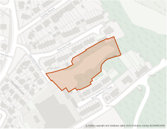
Site Size (ha) Gross: 0.60
Proposed Land Use: Housing
Minimum Development Capacity (Dwellings): 17
Site Type: Greenfield
Ward: Windhill & Wrose
Settlement: Bradford North East
Ownership: Private
Delivery Timescale: Medium 2030-2035 (6-10)
Site Specific Requirements
Design Principles
- Development should provide at least 17 dwellings as part of a high-quality built environment in line with Policies ST4 and DS1, at a net density of 50 dph in line with Policy HO2. This should include affordable housing (in line with Policy HO4) and an appropriate mix of dwellings (in line with Policy HO3 and having due regard to relevant housing needs, evidence and the character of the area).
Site Access, Highways and Transport
- New access required to Thornhill Avenue along with improvements to footways, emergency vehicle access and streetlighting.
Flooding, Water and Drainage
- There is a small area along the southern boundary of the site identified as being located within Flood Zones 2 and 3. Flood Risk Assessment is required to demonstrate that the risk of flooding is acceptably small and that any mitigation measure would not increase flood risk elsewhere.
Natural and Historic Environment
- Residential development resulting in a net increase in dwellings will be required to mitigate any recreational pressure on the SPA/SAC caused by such development in accordance with the South Pennine Moors SPD and Policy NE3.
- The site is an important greenspace with habitat value, meaning potential loss of biodiversity if developed. Also contains TPO trees/woodland (Woodland TPO toward the southern boundary of the site with buffer which covers more than 50% of the site). Early engagement with the Council's Biodiversity Officer is recommended.
Environmental Protection
- Site is within 150m buffer of a former landfill site. A Land Contamination Assessment – Phase 1 Report will be required as part of any planning application.
Open Space and Green / Blue Infrastructure
- Site is designated open space and/or Local Green Space (OSA - amenity greenspace) but loss would not result in a deficiency / exacerbate an existing deficiency for this typology and the area overall. Open space should be provided in line with Policy NE2, having regard to the standards set out in Appendix 11.
- Green and blue infrastructure should be provided in line with Policy NE1.
Infrastructure Requirements
- Proportionate contributions to community infrastructure will be required, where appropriate, in line with Policies ID1 and ID2, and having regard to the Local Infrastructure Plan (LIP).
Planning Permission
- An outline/detailed planning application (25/02547/MAO) is currently pending on this site for 17 homes which may be determined before the Local Plan is adopted
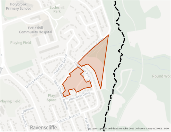
Site Size (ha) Gross: 3.01
Proposed Land Use: Housing
Minimum Development Capacity (Dwellings): 130
Site Type: MIXED
Ward: Eccleshill
Settlement: Bradford North East
Ownership: Private
Delivery Timescale: Short 2025-2030 (1-5)
Site Specific Requirements
Design Principles
- Development should provide at least 130 dwellings as part of a high-quality built environment in line with Policies ST4 and DS1. This should include affordable housing (in line with Policy HO4) and an appropriate mix of dwellings (in line with Policy HO3 and having due regard to relevant housing needs, evidence and the character of the area).
Site Access, Highways and Transport
- No significant access issue- Ranelagh Avenue can be used as an access. The road has streetlights and footways present.
Flooding, Water and Drainage
- Development should be possible at this site given the low fluvial and very low surface water flood risk to the site.
- It is recommended that Carr Brook is modelled for climate change as part of the site-specific Flood Risk Assessment (FRA) to understand any potential future fluvial risk posed to the site.
- The FRA must also show that the development can be designed to be safe and that there is adequate emergency planning provision.
Natural and Historic Environment
- The site is located within a bat alert area. An ecological survey will be required as part of any planning application to establish the extent/impacts as well as to identify appropriate mitigation.
Environmental Protection
- Site is within 150m buffer of a former landfill site. A Land Contamination Assessment – Phase 1 Report will be required as part of any planning application
- Site is within/partially within a Mineral Safeguarding Area (MSA) for Coal. A mineral resource assessment will be required as part of any planning application to determine the extent and availability of any Coal resource.
Open Space and Green / Blue Infrastructure
- Open space should be provided in line with Policy NE2, having regard to the standards set out in Appendix 11.
- Site is wholly within a Strategic Green Infrastructure Corridor (Tong/Calverley). Development of the site should ensure connectivity through the site to adjacent open space. Green and blue infrastructure should be provided in line with Policy NE1.
Infrastructure Requirements
- Proportionate contributions to community infrastructure will be required, where appropriate, in line with Policies ID1 and ID2, and having regard to the Local Infrastructure Plan (LIP).
Planning Permission
- An outline planning application (24/00940/MAO) is currently pending on this site for130 homes which may be determined before the Local Plan is adopted.
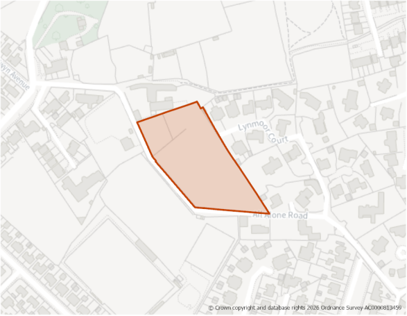
Site Size (ha) Gross: 0.97
Proposed Land Use: Housing
Minimum Development Capacity (Dwellings): 31
Site Type: PDL
Ward: Idle & Thackley
Settlement: Bradford North East
Ownership: Private
Delivery Timescale: Long 2035+ (11+)
Site Specific Requirements
Design Principles
- Development should provide at least 31 dwellings as part of a high-quality built environment in line with Policies ST4 and DS1. This should include affordable housing (in line with Policy HO4) and an appropriate mix of dwellings (in line with Policy HO3 and having due regard to relevant housing needs, evidence and the character of the area).
Site Access, Highways and Transport
- Provision of suitable access is a prerequirement for development.
Natural and Historic Environment
- Residential development resulting in a net increase in dwellings will be required to mitigate any recreational pressure on the SPA/SAC caused by such development in accordance with the South Pennine Moors SPD and Policy NE3.
Environmental Protection
- Site is within 150m buffer of a former landfill site. A Land Contamination Assessment – Phase 1 Report will be required as part of any planning application.
- Site is partially within a Development High Risk Area for coal mining, indicating that it contains one or more recorded former related features at surface or shallow depth. A Coal Mining Risk Assessment (CMRA) will be required as part of any planning application.
Open Space and Green / Blue Infrastructure
- Open space should be provided in line with Policy NE2, having regard to the standards set out in Appendix 11.
- Site is within an area of low provision and high need for green and blue infrastructure. Development proposals should focus on carefully designed green and blue infrastructure to contribute towards site specific issues e.g. flood mitigation, urban cooling etc. Green and blue infrastructure should be provided in line with Policy NE1.
Landscape
- Development should respect significant mature trees and historic features of site to create a positive sense of place.
Infrastructure Requirements
- Proportionate contributions to community infrastructure will be required, where appropriate, in line with Policies ID1 and ID2, and having regard to the Local Infrastructure Plan (LIP).
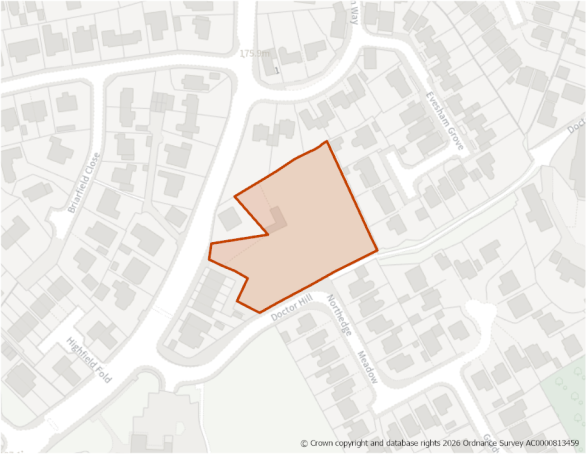
Site Size (ha) Gross: 0.42
Proposed Land Use: Housing
Minimum Development Capacity (Dwellings): 19
Site Type: Greenfield
Ward: Idle & Thackley
Settlement: Bradford North East
Ownership: Private
Delivery Timescale: Long 2035+ (11+)
Site Specific Requirements
Design Principles
- Development should provide at least 19 dwellings as part of a high-quality built environment in line with Policies ST4 and DS1, at a net density of 50 dph in line with Policy HO2. This should include affordable housing (in line with Policy HO4) and an appropriate mix of dwellings (in line with Policy HO3 and having due regard to relevant housing needs, evidence and the character of the area).
Site Access, Highways and Transport
- New access is required to join Highfield Road, where footways and streetlighting are present.
Natural and Historic Environment
- Residential development resulting in a net increase in dwellings will be required to mitigate any recreational pressure on the SPA/SAC caused by such development in accordance with the South Pennine Moors SPD and Policy NE3.
Environmental Protection
- Site is within 150m buffer of a former landfill site. A Land Contamination Assessment – Phase 1 Report will be required as part of any planning application.
- Housing density must conform with the limitations applicable to HSE Zone Rules.
Infrastructure Requirements
- Proportionate contributions to community infrastructure will be required, where appropriate, in line with Policies ID1 and ID2, and having regard to the Local Infrastructure Plan (LIP).
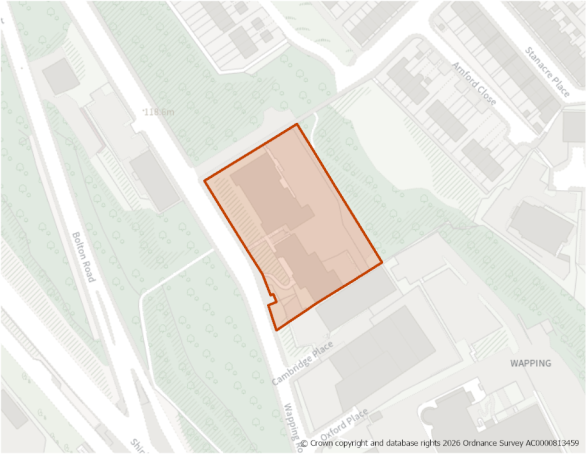
Site Size (ha) Gross: 0.51
Proposed Land Use: Housing
Minimum Development Capacity (Dwellings): 23
Site Type: PDL
Ward: Bowling & Barkerend
Settlement: Bradford North East
Ownership: Other
Delivery Timescale: Long 2035+ (11+)
Site Specific Requirements
Design Principles
- Development should provide at least 23 dwellings as part of a high-quality built environment in line with Policies ST4 and DS1, at a net density of 50 dph in line with Policy HO2. This should include affordable housing (in line with Policy HO4) and an appropriate mix of dwellings (in line with Policy HO3 and having due regard to relevant housing needs, evidence and the character of the area).
- Existing listed buildings provide potential positive frontage to Wapping Road contributing to sense of place should be retained.
Site Access, Highways and Transport
- The site fronts Wapping road, where footways and streetlights are present.
Flooding, Water and Drainage
- Future surface water risk is constrained by the area of existing development within the site. Any change in site layout where current buildings are to be demolished will require detailed surface water modelling.
- Safe access and escape routes in the low risk surface water event should be considered further through a site-specific Flood Risk Assessment (FRA).
Natural and Historic Environment
- The site is within/adjacent to bat alert area. Ecology survey may be required at the planning application stage. Early engagement with the Council's Biodiversity Officer is recommended.
- Site occupied by Grade II listed Wapping Road School. The buildings are derelict and require re-use and renovation, however their siignificance is such that loss and redevelopment would be very difficult to justify. Any development would be expected to find sympathetic solutions for the heritage assets.
Environmental Protection
- This site is located within the Clean Air Zone and development must be in accordance with the requirements set out in Policy CR1
- Site is within a Development High Risk Area for coal mining, indicating that it contains one or more recorded former related features at surface or shallow depth. A Coal Mining Risk Assessment (CMRA) will be required as part of any planning application.
- Site is within 150m buffer of a former landfill site. A Land Contamination Assessment – Phase 1 Report will be required as part of any planning application.
Open Space and Green / Blue Infrastructure
- Open space should be provided in line with Policy NE2, having regard to the standards set out in Appendix 11.
- The site lies within the Bradford City Centre Opportunity Area, as identified in the Green and Blue Infrastructure Strategy (GBIS). The strategy should be consulted to identify opportunities for incorporating measures within the development that enhance the quality of, and connectivity to, the green and blue infrastructure network in this area.
Infrastructure Requirements
- Proportionate contributions to community infrastructure will be required, where appropriate, in line with Policies ID1 and ID2, and having regard to the Local Infrastructure Plan (LIP).
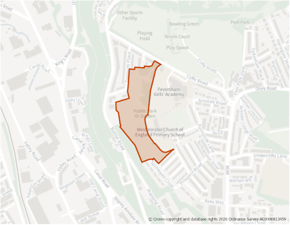
Site Size (ha) Gross: 4.39
Proposed Land Use: Housing
Minimum Development Capacity (Dwellings): 165
Site Type: Greenfield
Ward: Bolton & Undercliffe
Settlement: Bradford North East
Ownership: Private
Delivery Timescale: Medium 2030-2035 (6-10)
Site Specific Requirements
Design Principles
- Development should provide at least 165 dwellings as part of a high-quality built environment in line with Policies ST4 and DS1, at a net density of 50 dph in line with Policy HO2. This should include affordable housing (in line with Policy HO4) and an appropriate mix of dwellings (in line with Policy HO3 and having due regard to relevant housing needs, evidence and the character of the area).
Site Access, Highways and Transport
- New access is required that may potentially join Cliffe Road, where footways and streetlighting are present.
Natural and Historic Environment
- The site is adjacent to wildlife habitat network (grassland) and within bat alert area. Ecology survey may be required at the planning application stage. Early engagement with the Council's Biodiversity Officer is recommended.
Environmental Protection
- Site is within/partially within a Mineral Safeguarding Area (MSA) for Coal and Sandstone. A mineral resource assessment will be required as part of any planning application to determine the extent and availability of any Coal and/or Sandstone resource.
- Site is within 150m buffer of a former landfill site. A Land Contamination Assessment – Phase 1 Report will be required as part of any planning application.
- This site is located within the Clean Air Zone and development must be in accordance with the requirements set out in Policy CR1.
Open Space and Green / Blue Infrastructure
- The site contains open space site which may be lost due to development but could be mitigated by replacement provision on-site or off-site. Development of the site should ensure connectivity through the site to adjacent open space. Open space should be provided in line with Policy NE2, having regard to the standards set out in Appendix 11.
- The site lies within the Bradford City Centre Opportunity Area, as identified in the Green and Blue Infrastructure Strategy (GBIS). The strategy should be consulted to identify opportunities for incorporating measures within the development that enhance the quality of, and connectivity to, the green and blue infrastructure network in this area.
Landscape
- Site requires full analysis and masterplan to include retained green space, retained mature trees and consideration of pedestrian routes across the site. Elevated position on hillside makes the site visible from right across the other side of the valley so visual impact will need thorough assessment and mitigation measures put in place.
Infrastructure Requirements
- Proportionate contributions to community infrastructure will be required, where appropriate, in line with Policies ID1 and ID2, and having regard to the Local Infrastructure Plan (LIP).
H636: Land east of Harrogate Road (2), Greengates Comment
Site Boundary
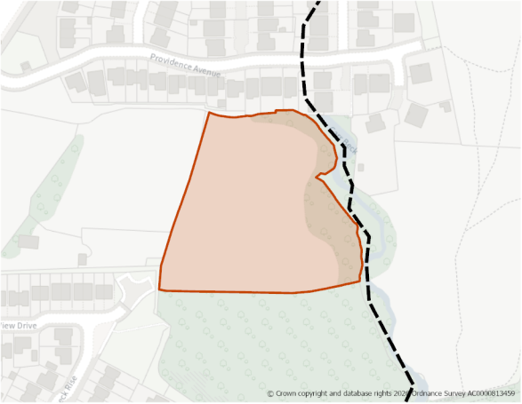
Site Size (ha) Gross: 1.00
Proposed Land Use: Housing
Minimum Development Capacity (Dwellings): 32
Site Type: Greenfield
Ward: Idle & Thackley
Settlement: Bradford North East
Ownership: Private
Delivery Timescale: Long 2035+ (11+)
Site Specific Requirements
Design Principles
- Development should provide at least 32 dwellings as part of a high-quality built environment in line with Policies ST4 and DS1, at a net density of 35 dph in line with Policy HO2. This should include affordable housing (in line with Policy HO4) and an appropriate mix of dwellings (in line with Policy HO3 and having due regard to relevant housing needs, evidence and the character of the area).
Site Access, Highways and Transport
- New access to be created to join Valley View Drive, where footways and streetlights are present.
Flooding, Water and Drainage
- Development on this site should avoid the eastern side of the site at modelled fluvial and surface water risk, and cannot be developed until the required information detailed in the SFRA on existing and future flood risk from Carr Beck is fully ascertained.
Natural and Historic Environment
- The site is adjacent to priority habitat and bat alert area. Ecology survey may be required at the planning application stage. Early engagement with the Council's Biodiversity Officer is recommended.
- Any impacts on the Leeds and Liverpool Canal CA should be mitigated through design, layout, scale, landscaping etc.
Environmental Protection
- Site is within/partially within a Mineral Safeguarding Area (MSA) for Coal, Sandstone, Sand and Gravel. A mineral resource assessment will be required as part of any planning application to determine the extent and availability of any Coal, Sandstone, Sand and Gravel resource.
Open Space and Green / Blue Infrastructure
- Development of the site should provided increased and improved public open space and also ensure connectivity through the site to adjacent open space. Open space should be provided in line with Policy NE2, having regard to the standards set out in Appendix 11.
- Green and blue infrastructure should be provided in line with Policy NE1.
Landscape
- The site is located within theEsholt Settled Valley Floor Landscape Character area/type (G3).
- Development should be offset from both the woodland and drop in topography in the east of the site. The level change between the site and Harrogate Road should be considered carefully within the design to ensure buildings do not tower over the existing streetscape and Listed Buildings. Links through to West Wood should be explored, to allow recreational access from any new development.
Green Belt (and Golden Rules)
- Site has been removed from the Green Belt. Development on the site should be consistent with the “Golden Rules” set out in the NPPF in relation to affordable housing, necessary improvements to infrastructure and accessible green space provision.
Infrastructure Requirements
- Proportionate contributions to community infrastructure will be required, where appropriate, in line with Policies ID1 and ID2, and having regard to the Local Infrastructure Plan (LIP).
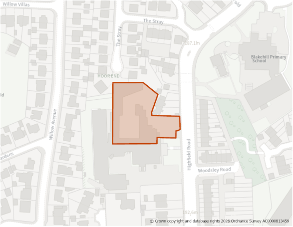
Site Size (ha) Gross: 0.34
Proposed Land Use: Housing
Minimum Development Capacity (Dwellings): 17
Site Type: PDL
Ward: Windhill & Wrose
Settlement: Bradford North East
Ownership: Private
Delivery Timescale: Long 2035+ (11+)
Site Specific Requirements
Design Principles
- Development should provide at least 17 dwellings as part of a high-quality built environment in line with Policies ST4 and DS1, at a net density of 50 dph in line with Policy HO2. This should include affordable housing (in line with Policy HO4) and an appropriate mix of dwellings (in line with Policy HO3 and having due regard to relevant housing needs, evidence and the character of the area).
Site Access, Highways and Transport
- The new access would to Highfield Road, where footways and streetlights are present.
Natural and Historic Environment
- Residential development resulting in a net increase in dwellings will be required to mitigate any recreational pressure on the SPA/SAC caused by such development in accordance with the South Pennine Moors SPD and Policy NE3.
- The site is close to bat roost/alert area. Ecology survey may be required at the planning application stage. Early engagement with the Council's Biodiversity Officer is recommended.
Infrastructure Requirements
- Proportionate contributions to community infrastructure will be required, where appropriate, in line with Policies ID1 and ID2, and having regard to the Local Infrastructure Plan (LIP).
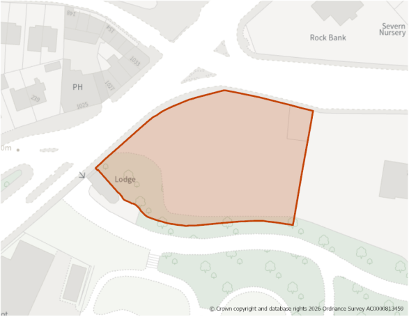
Site Size (ha) Gross: 0.31
Proposed Land Use: Housing
Minimum Development Capacity (Dwellings): 16
Site Type: PDL
Ward: Bolton & Undercliffe
Settlement: Bradford North East
Ownership: Private
Delivery Timescale: Long 2035+ (11+)
Site Specific Requirements
Design Principles
- Development should provide at least 16 dwellings as part of a high-quality built environment in line with Policies ST4 and DS1, at a net density of 50 dph in line with Policy HO2. This should include affordable housing (in line with Policy HO4) and an appropriate mix of dwellings (in line with Policy HO3 and having due regard to relevant housing needs, evidence and the character of the area).
Site Access, Highways and Transport
- Potential access leading onto Lister Lane may need a junction assessment to for suitability.
Natural and Historic Environment
- TPO trees/woodlands within to site. Site is also adjacent to habitat network areas. Development should be set back from these areas with additional new areas created within the site to provide linkages.
- The site is within/adjacent to bat alert area. Ecology survey may be required at the planning application stage. Early engagement with the Council's Biodiversity Officer is recommended.
- The site is within/partly within 50m buffer of Listed Building (Peel Park Lodge) and adjacent to a Historic Park & Garden (Peel Park). HIA would be required at the planning application stage. Early engagement with the Council's Heritage and Conservation Officer is recommended.
Environmental Protection
- This site is located within the Clean Air Zone and development must be in accordance with the requirements set out in Policy CR1.
- Site is within 150m buffer of a former landfill site. A Land Contamination Assessment – Phase 1 Report will be required as part of any planning application.
Open Space and Green / Blue Infrastructure
- Open space should be provided in line with Policy NE2, having regard to the standards set out in Appendix 11.
- The site lies within the Bradford City Centre Opportunity Area, as identified in the Green and Blue Infrastructure Strategy (GBIS). The strategy should be consulted to identify opportunities for incorporating measures within the development that enhance the quality of, and connectivity to, the green and blue infrastructure network in this area.
- This site is located within the Clean Air Zone and development must be in accordance with the requirements set out in Policy CR1.
Infrastructure Requirements
- Proportionate contributions to community infrastructure will be required, where appropriate, in line with Policies ID1 and ID2, and having regard to the Local Infrastructure Plan (LIP).
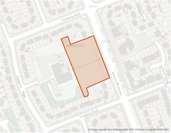
Site Size (ha) Gross: 0.50
Proposed Land Use: Housing
Minimum Development Capacity (Dwellings): 16
Site Type: PDL
Ward: Eccleshill
Settlement: Bradford North East
Ownership: Private
Delivery Timescale: Long 2035+ (11+)
Site Specific Requirements
Design Principles
- Development should provide at least 16 dwellings as part of a high-quality built environment in line with Policies ST4 and DS1, at a net density of 35 dph in line with Policy HO2. This should include affordable housing (in line with Policy HO4) and an appropriate mix of dwellings (in line with Policy HO3 and having due regard to relevant housing needs, evidence and the character of the area).
Site Access, Highways and Transport
- The new access should join Ravenscliffe Avenue, where footways and streetlights are present.
Open Space and Green / Blue Infrastructure
- Open space should be provided in line with Policy NE2, having regard to the standards set out in Appendix 11.
- Site is within an area of low provision and high need for green and blue infrastructure. Development proposals should focus on carefully designed green and blue infrastructure to contribute towards site specific issues e.g. flood mitigation, urban cooling etc. Green and blue infrastructure should be provided in line with Policy NE1.
Infrastructure Requirements
- Proportionate contributions to community infrastructure will be required, where appropriate, in line with Policies ID1 and ID2, and having regard to the Local Infrastructure Plan (LIP).
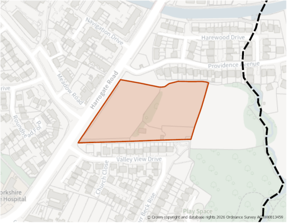
Site Size (ha) Gross: 1.54
Proposed Land Use: Housing
Minimum Development Capacity (Dwellings): 49
Site Type: Greenfield
Ward: Idle & Thackley
Settlement: Bradford North East
Ownership: Public
Delivery Timescale: Long 2035+ (11+)
Site Specific Requirements
Design Principles
- Development should provide at least 49 dwellings as part of a high-quality built environment in line with Policies ST4 and DS1, at a net density of 35 dph in line with Policy HO2. This should include affordable housing (in line with Policy HO4) and an appropriate mix of dwellings (in line with Policy HO3 and having due regard to relevant housing needs, evidence and the character of the area).
Site Access, Highways and Transport
- The new access would join Valley View Drive, where footways and streetlights are present.
Natural and Historic Environment
- Partly within 50m buffer of Listed Building/Buildings (997 Harrogate Rd). Early engagement with the Council's Heritage and Conservation Officer is recommended.
- The site is located within a bat alert area. An ecological survey will be required as part of any planning application to establish the extent/impacts as well as to identify appropriate mitigation.
Environmental Protection
- Site is within/partially within a Mineral Safeguarding Area (MSA) for Coal and Sandstone. A mineral resource assessment will be required as part of any planning application to determine the extent and availability of any Coal and/or Sandstone resource.
Open Space and Green / Blue Infrastructure
- Open space should be provided in line with Policy NE2, having regard to the standards set out in Appendix 11.
- The site falls within Bradford Green Infrastructure Opportunity Corridors. Developer should identify opportunities for incorporating measures within the development that enhance the quality of, and connectivity to, the green/ blue infrastructure network in this area. Green and blue infrastructure should be provided in line with Policy NE1.
Landscape
- The site is located within theEsholt Settled Valley Floor Landscape Character area/type (G3).
- The site is designated as part of enclosed pasture, characterized by a distinct and visible historic continuity that is highly sensitive to change. Future residential development must be carefully designed to ensure it does not significantly detract from the existing landscape character.
Infrastructure Requirements
- Proportionate contributions to community infrastructure will be required, where appropriate, in line with Policies ID1 and ID2, and having regard to the Local Infrastructure Plan (LIP).
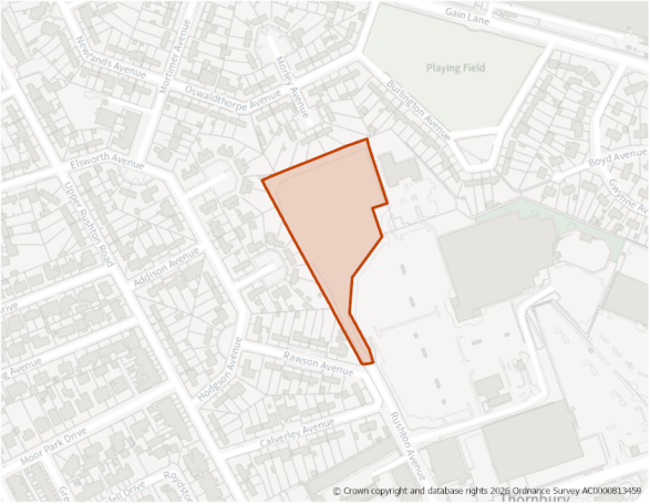
Site Size (ha) Gross: 1.15
Proposed Land Use: Housing
Minimum Development Capacity (Dwellings): 53
Site Type: PDL
Ward: Bradford Moor
Settlement: Bradford North East
Ownership: Private
Delivery Timescale: Short 2025- 2030 (1-5)
Site Specific Requirements
Design Principles
- Development should provide at least 53 dwellings as part of a high-quality built environment in line with Policies ST4 and DS1, at a net density of 50 dph in line with Policy HO2. This should include affordable housing (in line with Policy HO4) and an appropriate mix of dwellings (in line with Policy HO3 and having due regard to relevant housing needs, evidence and the character of the area).
Site Access, Highways and Transport
- The existing access leads to Rushton Avenue, where footways and streetlights are present. Widening may be required.
Environmental Protection
- Site is within/partially within a Mineral Safeguarding Area (MSA) for Coal and Sandstone. A mineral resource assessment will be required as part of any planning application to determine the extent and availability of any Coal and/or Sandstone resource.
Infrastructure Requirements
- Proportionate contributions to community infrastructure will be required, where appropriate, in line with Policies ID1 and ID2, and having regard to the Local Infrastructure Plan (LIP).
Planning Permission
- 1. Site benefits from planning permission for 52 dwellings (25/01094/MAF ) granted in February 2026. This was after 1 April 2025 (the base date for the Local Plan). Accordingly, it has been identified as a site allocation. Development of this site should take place in line with the approved planning permission.
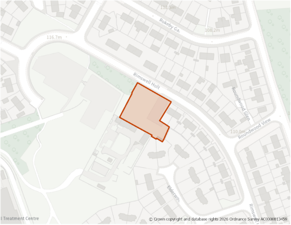
Site Size (ha) Gross: 0.20
Proposed Land Use: Housing
Minimum Development Capacity (Dwellings): 7
Site Type: PDL
Ward: Eccleshill
Settlement: Bradford North East
Ownership: Other
Delivery Timescale: Long 2035+ (11+)
Site Specific Requirements
Design Principles
- Development should provide at least 7 dwellings as part of a high-quality built environment in line with Policies ST4 and DS1, at a net density of 35 dph in line with Policy HO2. This should include affordable housing (in line with Policy HO4) and an appropriate mix of dwellings (in line with Policy HO3 and having due regard to relevant housing needs, evidence and the character of the area).
Site Access, Highways and Transport
- The new access would join Rimswell Holt, where footways and streetlights are present.
Natural and Historic Environment
- The site is in close proximity to TPO woodland and habitat features suitable for bats and is therefore an increased likelihood of a bat roost being present. Ecology survey may be required at the planning application stage. Early engagement with the Council's Biodiversity Officer is recommended.
- The site is located within a bat alert area. An ecological survey will be required as part of any planning application to establish the extent/impacts as well as to identify appropriate mitigation.
Infrastructure Requirements
- Proportionate contributions to community infrastructure will be required, where appropriate, in line with Policies ID1 and ID2, and having regard to the Local Infrastructure Plan (LIP).
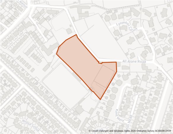
Site Size (ha) Gross: 2.19
Proposed Land Use: Housing
Minimum Development Capacity (Dwellings): 57
Site Type: Greenfield
Ward: Windhill & Wrose
Settlement: Bradford North East
Ownership: Private
Delivery Timescale: Medium 2030-2035 (6-10)
Site Specific Requirements
Design Principles
- Development should provide at least 57 dwellings as part of a high-quality built environment in line with Policies ST4 and DS1, at a net density of 35 dph in line with Policy HO2. This should include affordable housing (in line with Policy HO4) and an appropriate mix of dwellings (in line with Policy HO3 and having due regard to relevant housing needs, evidence and the character of the area).
Site Access, Highways and Transport
- Suitable access is a prerequisite for the development of the site.
Natural and Historic Environment
- Residential development resulting in a net increase in dwellings will be required to mitigate any recreational pressure on the SPA/SAC caused by such development in accordance with the South Pennine Moors SPD and Policy NE3.
Environmental Protection
- Site is within/partially within a Mineral Safeguarding Area (MSA) for Coal and Sandstone. A mineral resource assessment will be required as part of any planning application to determine the extent and availability of any Coal and/or Sandstone resource.
- Site is partially within a Development High Risk Area for coal mining, indicating that it contains one or more recorded former related features at surface or shallow depth. A Coal Mining Risk Assessment (CMRA) will be required as part of any planning application.
- Site is within 150m buffer of a former landfill site. A Land Contamination Assessment – Phase 1 Report will be required as part of any planning application.
Open Space and Green / Blue Infrastructure
- The site contains open space site which may be lost due to development but could be mitigated by appropriate replacement provision on-site or off-site. Open space should be provided in line with Policy NE2, having regards to the standards set out in Appendix 11.
- Green and blue infrastructure should be provided in line with Policy NE1.
Landscape
- Development should respect significant mature trees and historic features of site to create a positive sense of place.
Infrastructure Requirements
- Proportionate contributions to community infrastructure will be required, where appropriate, in line with Policies ID1 and ID2, and having regard to the Local Infrastructure Plan (LIP).
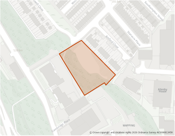
Site Size (ha) Gross: 0.49
Proposed Land Use: Housing
Minimum Development Capacity (Dwellings): 22
Site Type: Greenfield
Ward: Bowling & Barkerend
Settlement: Bradford North East
Ownership: Mixed
Delivery Timescale: Long 2035+ (11+)
Site Specific Requirements
Design Principles
- Development should provide at least 22 dwellings as part of a high-quality built environment in line with Policies ST4 and DS1, at a net density of 50 dph in line with Policy HO2. This should include affordable housing (in line with Policy HO4) and an appropriate mix of dwellings (in line with Policy HO3 and having due regard to relevant housing needs, evidence and the character of the area).
Site Access, Highways and Transport
- New access should join Prospect Road, where footways and streetlights are present.
Natural and Historic Environment
- Located within 50m buffer of Listed Building/Buildings (Grade II-Wapping First School). Early engagement with the Council's Heritage and Conservation Officer is recommended.
- The site is in close proximity to habitat features suitable for bats and is therefore an increased likelihood of a bat roost being present. An ecological survey will be required as part of any planning application to establish the extent/impacts as well as to identify appropriate mitigation.
Environmental Protection
- This site is located within the Clean Air Zone and development must be in accordance with the requirements set out in Policy CR1.
- Site is within a Development High Risk Area for coal mining, indicating that it contains one or more recorded former related features at surface or shallow depth. A Coal Mining Risk Assessment (CMRA) will be required as part of any planning application.
- Site is within 150m buffer of a former landfill site. A Land Contamination Assessment – Phase 1 Report will be required as part of any planning application.
Open Space and Green / Blue Infrastructure
- Open space should be provided in line with Policy NE2, having regard to the standards set out in Appendix 11.
- Most of the site also falls within the draft Bradford Green Infrastructure Opportunity Corridors. However these are large / wider area of GI so the site's development would not result in full severance of the network. Development of the site should ensure connectivity through the site to adjacent open space.
- The site lies within the Bradford City Centre Opportunity Area, as identified in the Green and Blue Infrastructure Strategy (GBIS). The strategy should be consulted to identify opportunities for incorporating measures within the development that enhance the quality of, and connectivity to, the green and blue infrastructure network in this area.
- This site is located within the Clean Air Zone and development must be in accordance with the requirements set out in Policy CR1.
Infrastructure Requirements
- Proportionate contributions to community infrastructure will be required, where appropriate, in line with Policies ID1 and ID2, and having regard to the Local Infrastructure Plan (LIP).
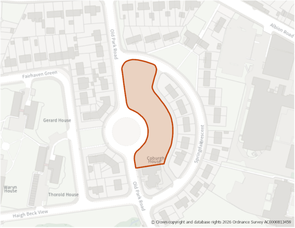
Site Size (ha) Gross: 0.35
Proposed Land Use: Housing
Minimum Development Capacity (Dwellings): 18
Site Type: Greenfield
Ward: Idle & Thackley
Settlement: Bradford North East
Ownership: Private
Delivery Timescale: Long 2035+ (11+)
Site Specific Requirements
Design Principles
- Development should provide at least 18 dwellings as part of a high-quality built environment in line with Policies ST4 and DS1, at a net density of 50 dph in line with Policy HO2. This should include affordable housing (in line with Policy HO4) and an appropriate mix of dwellings (in line with Policy HO3 and having due regard to relevant housing needs, evidence and the character of the area).
Site Access, Highways and Transport
- A new access should join Springdale Crescent, where footways and streetlighting are present.
Natural and Historic Environment
- Residential development resulting in a net increase in dwellings will be required to mitigate any recreational pressure on the SPA/SAC caused by such development in accordance with the South Pennine Moors SPD and Policy NE3.
Environmental Protection
- Site is partially within a Development High Risk Area for coal mining, indicating that it contains one or more recorded former related features at surface or shallow depth. A Coal Mining Risk Assessment (CMRA) will be required as part of any planning application.
Open Space and Green / Blue Infrastructure
- Open space should be provided in line with Policy NE2, having regard to the standards set out in Appendix 11.
- Development on the site should maximise any opportunity to retain and/or enhance the aesthetical relationship between built form and surrounding green space. Green and blue infrastructure should be provided in line with Policy NE1.
Infrastructure Requirements
- Proportionate contributions to community infrastructure will be required, where appropriate, in line with Policies ID1 and ID2, and having regard to the Local Infrastructure Plan (LIP).
H1558: Land at Friars Industrial Estate, Idle (1) Comment
Site Boundary
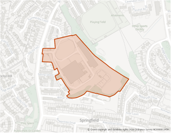
Site Size (ha) Gross: 3.89
Proposed Land Use: Housing
Minimum Development Capacity (Dwellings): 146
Site Type: PDL
Ward: Eccleshill
Settlement: Bradford North East
Ownership: Private
Delivery Timescale: Long 2035+ (11+)
Site Specific Requirements
Design Principles
- Development should provide at least 146 dwellings as part of a high-quality built environment in line with Policies ST4 and DS1, at a net density of 50 dph in line with Policy HO2. This should include affordable housing (in line with Policy HO4) and an appropriate mix of dwellings (in line with Policy HO3 and having due regard to relevant housing needs, evidence and the character of the area).
- The layout of the site will need to be mindful of the relationship with its neighbouring uses and ensure new development takes account of any environmental sensitivity and is well designed in line with Policies DS1 and DS3.
Site Access, Highways and Transport
- Existing established access from Bradford road should be retained.
Natural and Historic Environment
- Residential development resulting in a net increase in dwellings will be required to mitigate any recreational pressure on the SPA/SAC caused by such development in accordance with the South Pennine Moors SPD and Policy NE3.
- Southern part of the site is partially covered by priority habitat (deciduous woodland) and within bat alert area. Ecology survey may be required and early engagement with the Council's Biodiversity Officer is recommended.
- Adjacent to Grade II listed cottages on Spring Street but development could be achieved without harm to setting.
Environmental Protection
- Site is within/partially within a Mineral Safeguarding Area (MSA) for Coal and Sandstone. A mineral resource assessment will be required as part of any planning application to determine the extent and availability of any resource.
- Site is partially within a Development High Risk Area for coal mining, indicating that it contains one or more recorded former related features at surface or shallow depth. A Coal Mining Risk Assessment (CMRA) will be required as part of any planning application.
- Site is within 150m buffer of a former landfill site. A Land Contamination Assessment – Phase 1 Report will be required as part of any planning application.
Infrastructure Requirements
- Proportionate contributions to community infrastructure will be required, where appropriate, in line with Policies ID1 and ID2, and having regard to the Local Infrastructure Plan (LIP).
MDS1: Esholt Wastewater Treatment Works North Comment
Site Boundary
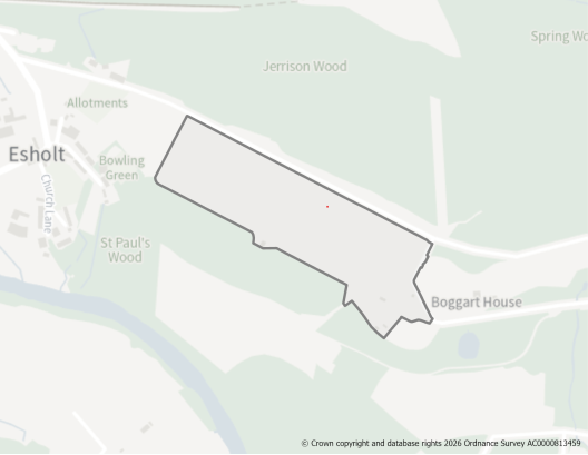
Site Size (ha) Gross: 5.78
Proposed Land Use: Housing
Minimum Development Capacity (Dwellings): 150
Site Type: PDL
Ward: Baildon
Ownership: Private
Delivery Timescale: Short 2025- 2030 (1-5)
Site Specific Requirements
Site Access, Highways and Transport
- The development establishes a suitable access arrangements including for active travel and public transport options.
Green Belt
- The general openness of the Green Belt is maintained, with particular consideration given to the extent of the existing footprint, and the height and massing of the proposed development, as well as the degree of activity likely to be generated.
Green and Blue Infrastructure
- A comprehensive green and blue infrastructure plan is provided which demonstrates how the development integrates into the unique landscape setting.
Planning Status
- Site forms part of a hybrid planning application which Planning Committee had Resolved to Grant, subject to a s.106 agreement at the plan base date.
MDS2: Esholt Wastewater Treatment Works South Comment
Site Boundary
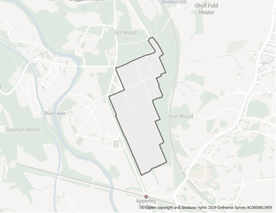
Site Size (ha) Gross: 27.09
Net Developable Area (ha): 27.09
Proposed Land Use: Employment (Eg(i), Eg(ii), Eg(iii), B2, B8
Site Type: Brownfield
Ward: Idle and Thackley
Ownership: Private
Delivery Timescale: 2027-2043
Site Specific Requirements
The redevelopment of this site will be supported where:
Site Access, Highways and Transport
- The development establishes a suitable access arrangements including for active travel and public transport options.
Green Belt
- The general openness of the Green Belt is maintained, with particular consideration given to the extent of the existing footprint, and the height and massing of the proposed development, as well as the degree of activity likely to be generated.
Green and Blue Infrastructure
- A comprehensive green and blue infrastructure plan is provided which demonstrates how the development integrates into the unique landscape setting.
Planning Status
- Site forms part of a hybrid planning application which Planning Committee had Resolved to Grant, subject to a s.106 agreement at the plan base date.
