

Bradford District Local Plan - Publication Draft (Regulation 19) (October 2026)
Policy BSW1: Bradford South West
Introduction
The Local Plan settlement hierarchy identifies Bradford South West as one of for quadrant areas within the wider Regional City of Bradford. It is broadly defined by Thornton Road to the north, A641 Manchester Road / Huddersfield Road to the East and Green Belt land to the south and west. It covers an area of approximately 1,685 hectares and is predominantly residential in character, with strong connections to Bradford City Centre and commuter connections to Halifax, Huddersfield, Leeds, Manchester and London.
Bradford South West includes Great Horton and Royds wards, together with large parts of Wibsey, Little Horton, Clayton and Fairweather Green, and parts of Queensbury and City wards. The area encompasses a diverse range of neighbourhoods, broadly grouped around Great and Little Horton, Royds and Wibsey, including Buttershaw and Woodside, and Clayton and Clayton Heights.
The sub-area is predominantly urban but varies considerably in character, from densely developed inner neighbourhoods and areas of traditional terraced housing closer to Bradford City Centre, through to established suburban neighbourhoods and post-war estates, to lower-density development adjoining the Green Belt and rural fringe in the south and west. Great Horton District Centre, together with a network of local centres, provides an important focus for shops, services and community facilities.
Bradford South West contains significant opportunities for housing-led regeneration and the reuse of brownfield land, alongside the need to improve the quality and choice of housing and support the renewal of existing neighbourhoods. Development will need to be supported by appropriate infrastructure and improvements to sustainable travel connections, whilst addressing the impacts of traffic and supporting access to employment, centres and services.
The area’s extensive network of green infrastructure is an important part of its character and includes Judy Woods, Horton Country Park and Horton Park, together with green and blue corridors such as Pinch Beck, Bull Greave Beck and Clayton Beck. Future development will need to protect and enhance these assets, biodiversity and open space networks, whilst responding sensitively to the relationship between the urban area, Green Belt and rural fringe.
POLICY BSW1 BRADFORD SOUTH WEST Comment
Settlement Plan
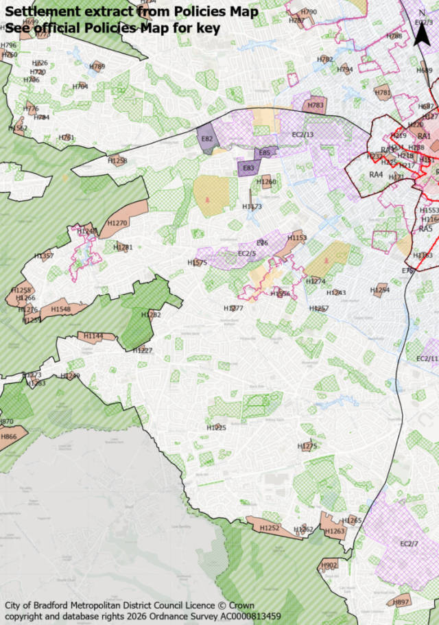
Settlement Hierarchy and Spatial Directions
- Bradford South West is defined on the Policies Map and forms part of the Regional City. It will support the regeneration of existing communities and the delivery of new homes and investment, focused on creating healthy, sustainable and well-connected neighbourhoods. Development will make effective use of previously developed land, strengthen local services, improve sustainable transport and green infrastructure, and respond positively to the distinctive character of individual neighbourhoods and the area’s relationship with the surrounding countryside.
- Housing growth will focus on maximising opportunities for the reuse of previously developed and under-utilised land and buildings, together with appropriate development opportunities in urban fringe areas, including land released from the Green Belt, and new sites within the settlement boundary. A range of house types, sizes and tenures will be supported to broaden housing choice and meet the needs of different communities, including family, older people’s and specialist housing. Development will support the regeneration of existing urban areas, including the economic, environmental, physical and social transformation of key areas such as Buttershaw and Woodside.
- Local businesses and employment areas will continue to be supported, including the Employment Zones at Paradise Green and Thornton Road, and established employment areas around Legrams Lane, Beckside Road, Great Horton Road and Halifax Road. Investment will support business growth and diversification, strengthen Great Horton District Centre and the area’s Local Centres, and improve connections between communities, employment, services and facilities.
- Investment in community infrastructure will be supported to improve access to local services and facilities, particularly in neighbourhoods experiencing higher levels of deprivation. Opportunities will be supported to address identified deficiencies in open space provision, particularly natural and semi-natural greenspace, outdoor sports, parks and play provision, with priority given to areas of greatest need and poor accessibility.
Meeting Growth Needs
- Housing development in the Bradford South West will deliver approximately 2,897 dwellings through a combination of sites within the urban area and land released from the Green Belt from sites under construction, with planning permission and new site allocations during the plan period, as set out in Table BSW 1.1
Table BSW1.1 – Bradford South West
|
Under Construction |
Planning Permission |
Site Allocations |
|
|
Totals |
260 |
107 |
2,530 |
- Deliver housing site allocations as shown on the Policies Map and the site proformas within section 5. Proposals for new homes within the settlement boundary on additional small sites outside of the town centre, including the redevelopment of previously developed land, will also be supported subject to meeting policies HO3 and DS3.
- The Council will work with developers, infrastructure providers and other partners to support the coordinated delivery of housing growth across Bradford South West, ensuring that development is supported by the necessary infrastructure, services and facilities and is successfully integrated with existing communities. Delivery will also support wider regeneration objectives, including the continued transformation of Buttershaw and Woodside.
Local Services and Facilities
- The Council will take a positive approach to retail growth and the vitality of Great Horton District Centre and the designated Local Centres, through enhancing their diverse range of retail, service and leisure uses and supporting the retention and improvement of other local services and facilities.
- Development will protect and enhance existing open spaces and green and blue infrastructure, and improve their accessibility and connectivity. Opportunities will be taken to strengthen key green corridors, including Judy Woods, Horton Country Park and Horton Park, and blue corridors along Pinch Beck, Bull Greave Beck and Clayton Beck, providing improved ecological connections and routes for walking and cycling.
- Development will support the protection and enhancement of existing sport and recreation facilities, and the provision of additional facilities where required to address identified deficiencies and improve community access.
Landscape
- Development will maintain and enhance the landscape character and setting of Bradford South West, including its distinctive wooded valleys and slopes, and respect the transition between the urban area and the Green Belt and rural landscape to the south and west.
Historic and Natural Environment
- Development will protect and enhance designated Local Wildlife Sites, priority habitats and other areas of biodiversity value within and adjoining Bradford South West, including Horton Country Park, Judy Woods, Railway Terrace and Raw Nook/Toad Holes Beck.
- Development will conserve and, where appropriate, enhance the historic environment of Bradford South West, including the character and setting of the Little Horton, Little Horton Green, Great Horton and Clayoton Conservation Areas, Listed Buildings and non-designated heritage assets.
- Residential development within the SPA/SAC Zone C (Recreational Pressure) will be required to mitigate any recreational pressure on the SPA/SAC arising from the development in accordance with the South Pennine Moors SPD and Policy EN3.
- Development in areas affected by former coal mining activity will be required to demonstrate that land stability and associated risks can be appropriately addressed. Development should also contribute to the protection and improvement of air quality, particularly in and around designated Air Quality Management Areas and other locations where air quality is a concern.
Local Infrastructure
- Development should support improvements to public transport and active travel connections within and beyond Bradford South West, including, where relevant, along the Manchester Road, Great Horton Road and Thornton Road corridors and connections to Bradford City Centre and the wider area. Safe and attractive walking, wheeling and cycling routes will improve connections between residential neighbourhoods, local centres, employment areas, services and facilities.
- Development will be expected to support the provision and improvement of community infrastructure required to meet the needs arising from growth, including education, healthcare and other local services and facilities.
Bradford South West: Site Allocations
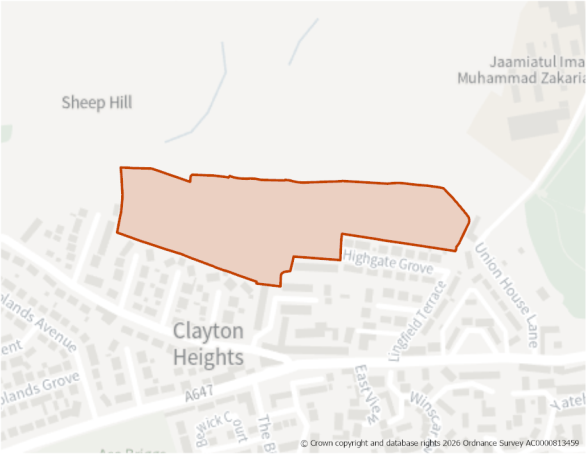
Site Size (ha) Gross: 4.47
Proposed Land Use: Housing
Minimum Development Capacity (Dwellings): 117
Site Type: Greenfield
Ward: Queensbury
Settlement: Bradford South West
Ownership: Private
Delivery Timescale: Medium 2030-2035 (6-10 years)
Site Specific Requirements: Design Principles
- The site is open greenfield land in an edge-of-settlement location, which has been released from the Green Belt.
- Development should provide at least 117 dwellings as part of a high-quality built environment in line with Policies ST4 and DS1, at a net density of 35 dph in line with Policy HO2. This should include affordable housing (in line with Policy HO4) and an appropriate mix of dwellings (in line with Policy HO3 and having due regard relevant housing needs evidence and the character of the area).
- The design and layout of any future development should respond positively to the green infrastructure within the site and the adjacent SPA/SAC, on-site flood risk constraints, and local heritage impacts.
- Enhancements to the surrounding Green Belt land should be made, including improving connections to offer opportunities for residents to access the countryside.
Site Access, Highways and Transport
- Access to the site is via Lingfield Terrace and Highgate Grove. Development will be required to deliver necessary highway safety improvements at the junctions of Lingfield Terrace and Highgate Road and Highgate Close. This must include the incorporation of dropped footway crossings, implementation of adequate visibility splays, and consideration of road and footway widening, where appropriate.
- The site is located within 400m of High Frequency Bus Network service bus stops providing direct access to Bradford City Centre and Halifax. Development will be required to optimise pedestrian connectivity to the network on Highgate Road.
Flooding, Water and Drainage
- The site is within Flood Zone 1. There is a risk of flooding to subsurface assets but surface manifestation of groundwater is unlikely. Development will be expected to be served by acceptable drainage infrastructure based on SuDS principles in line with Policy CR4.
Natural and Historic Environment
- The site lies within Zone C (Recreational Pressure) of the South Pennine Moors SPA/SAC - Residential development resulting in a net increase in dwellings will be required to mitigate any recreational pressure on the SPA/SAC caused by such development in accordance with the South Pennine Moors SPD and Policy NE3. The site is in Zone C of the South Pennine Moors SPA/SAC 7km recreational pressure impact zone.
- The site is located within a Wildlife Habitat Network (semi-rural grassland) and partially within a Bat Alert Area. The site is also identified in the LNRS with the preferred measure G1_M03: Restore and enhance existing species-rich grasslands. An Ecology Survey will likely be required at planning stage. Early engagement with the Council’s Biodiversity Officer is recommended.
- Ecological enhancements should be prioritised on-site, utilising the large open space buffer on the northern edge of the allocation to deliver meaningful habitat creation to meet BNG requirements.
- The site is located within the setting of the Grade II Listed Jaamiatul Imaam Muhammad Zakaria School to the north east and Grade II Listed Buildings Highgate Mills, Highgate Road and Highgate Mill Farm, 18 Back Lane, to the south. There are a number of other Listed Buildings within the vicinity, together with a group of mid-19th century cottages at Nab End which would be considered non-designated heritage assets.
- The design of any development proposal will need to respect the character and setting of designated and non-designated heritage assets, having regard for the semi-rural nature of the application site.
- This site is within a Bat Alert Area. Any future development must be supported by a bat survey. The layout should retain an undeveloped, unlit green infrastructure buffer along the northern boundary to protect bat foraging routes and link to the adjacent habitat corridor. Early engagement with the Council’s Biodiversity Officer is recommended.
Environmental Protection
- The site contains extensive areas of Made Ground with localised soil contamination and ground gas risks. A comprehensive Phase 2 Intrusive Site Investigation and Remediation Strategy will be required as part of any residential-led planning application. Development proposals must incorporate a robust remediation strategy and validated ground protection measures to ensure the site is safe for residential use.
- Development layout must mitigate resident exposure to road emissions and demonstrate that site-generated traffic will not worsen air quality along the nearby NO2 30+ corridor on Highgate Road.
Open Space and Green / Blue Infrastructure
- Open space should be provided in line with Policy NE2, having regards to the standards set out in Appendix 11 and satisfying the ‘Golden Rules’ criteria of the NPPF, having due regard to the requirement for new or enhanced publicly-accessible green space. The layout must preserve a substantial open green space buffer across the northern edge of the site to maintain strategic connectivity. The Open Space Assessment indicates that in Bradford South West there is a need for increased provision of Natural and Semi-natural Greenspace, Outdoor Sports, Parks and Provision for Children.
- The northern portion of the site lies within a Green Infrastructure Opportunity Corridor, as identified in the Green and Blue Infrastructure Strategy (GBIS), situated between two established Green Infrastructure Corridors. The strategy should be consulted to identify opportunities for incorporating measures within the development that enhance the quality of, and connectivity to, the green and blue infrastructure network in this area.
- The site is partially within an area of low provision and high need for green and blue infrastructure. Development proposals should focus on carefully designed green and blue infrastructure to contribute towards site specific issues, such as flood mitigation and urban cooling.
- The design and layout of any development should ensure due consideration is given to the site’s Green Infrastructure connectivity and enhancement.
Landscape
- The site is located within the Thornton, Queensbury and Wilsden Mixed Upland Pasture Landscape Character area/type (E1). The Council’s Landscape Sensitivity Assessment identifies the site as having medium sensitivity to change, owing to its elevated location and sloping landform, with high visual exposure from the north.
- Development layout must be designed to minimise visual impacts when viewed from further afield, particularly from the north. The layout must concentrate the built footprint against the urban edge and preserve the northern edge of the site as an open space green buffer, incorporating high-quality planting and boundary landscaping.
- Tree planting would also be considered an appropriate way to integrate development into the landscape, as part of a high-quality landscaping strategy which ensures the surrounding landscape is protected.
- A detailed landscape assessment will be required to demonstrate how the development aligns with guidance set out in the Council’s Landscape Character Assessment SPD.
Green Belt (and Golden Rules
- This site has been removed from the Green Belt. Development on the site should be consistent with the “Golden Rules” set out in the NPPF in relation to affordable housing, necessary improvements to infrastructure and accessible green space provision.
Infrastructure Requirements
- Proportionate contributions to community infrastructure will be required, where appropriate, in line with Policies ID1 and ID2, and having regard to the Local Infrastructure Plan.
Planning Permission
- The site benefits from outline planning permission for the construction of residential development (25/03438/MAO) granted in February 2026. Whilst the outline permission does not specify the number of dwellings, the approved plans indicate a development of approx. 60 dwellings, which has been used as the indicative site capacity. Development of the site should take place in accordance with the outline planning permission and any subsequent reserved matters approval.
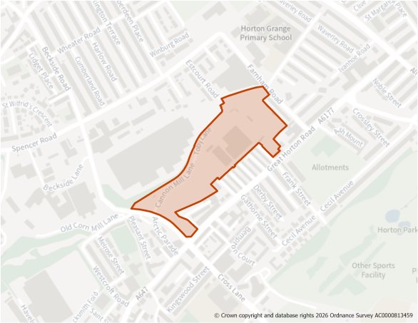
Site Size (ha) Gross: 4.99
Proposed Land Use: Housing
Minimum Development Capacity (Dwellings): 187
Site Type: PDL
Ward: City
Settlement: Bradford South West
Ownership: Private
Delivery Timescale: Long 2035+ (11+)
Site Specific Requirements:
Design Principles
- The site is a large PDL site comprising a 3/4 storey grade II listed mill and extensive sloping and level surfaces.
- The site is allocated for residential development. Development should provide at least 187 dwellings as part of a high-quality built environment in line with Policies ST4 and DS1, at a net density of 50 dph in line with Policy HO2. This should include affordable housing (in line with Policy HO4) and an appropriate mix of dwellings (in line with Policy HO3 and having due regard relevant housing needs evidence and the character of the area).
- Any scheme would need to retain and convert the mill and sensitively incorporate development around the site, maintaining the setting of the listed buildings. A Landscape and Visual Impact Assessment will need to be carried out.
- A sensitive design and layout will be required taking into consideration the heritage asset and the sloping nature of the site. This should include appropriate landscaping in line with Policy DS2 and on site open space.
Site Access, Highways and Transport
- Site access is via Cannon Mill Lane from Beckside Road. This should be designed to respond to the sites contours and to the satisfaction of the Councils Highways Officers
Flooding, Water and Drainage
- The site is in Flood Zone 1. There is a risk of groundwater flooding to both surface and subsurface assets. Groundwater may emerge at significant rates and has the capacity to flow overland and/or pond within any topographic low spots. Development will be expected to be served by acceptable drainage infrastructure based on SuDS principles in line with Policy CR4.
Natural and Historic Environment
- The site abuts the Great Horton conservation area to the southern corner.
- Cannon Mill is a Grade II Listed Building as are the nearby terraced properties to the south east of the site. A Heritage Impact Assessment has been undertaken on this site. Full regard to be given to retention of the heritage assets and their sympathetic conversion. This must be the primary objective but the regeneration of the wider site will support the viability of this. Development of the site to embody the objectives of enhancing the sustainability of the assets and enhancing their settings through appropriate design and landscaping.
- Development of the proposed site should strive to have an impact of Less than substantial harm of an acceptable level with the potential to improve the setting of the listed building and support its regeneration.
Environmental Protection
- Development layout must mitigate resident exposure to road emissions and demonstrate that site-generated traffic will not worsen air quality along the nearby NO2 30+ corridor on Great Horton Road.
- Site is partially within a Development Low Risk Area for coal mining , indicating that it contains one or more recorded former related features at surface or shallow depth. A Coal Mining Risk Assessment (CMRA) will be required as part of any planning application.
- Site majority of the site to the east is within 150m and 250m buffer of a former landfill site. A Land Contamination Assessment – Phase 1 Report will be required as part of an application.
Open Space and Green / Blue Infrastructure
- Open space should be provided in line with Policy NE2, having regards to the standards set out Appendix 11.
- Site is partially within an area of medium provision and high need for green and blue infrastructure. Development proposals should focus on carefully designed green and blue infrastructure to contribute towards site specific issues e.g. flood mitigation, urban cooling, etc.
Infrastructure Requirements
- Proportionate contributions to community infrastructure will be required, where appropriate, in line with Policies ID1 and ID2, and having regard to the Local Infrastructure Plan.
H1173: Legrams Lane, Lidget Green Comment
Site Boundary:
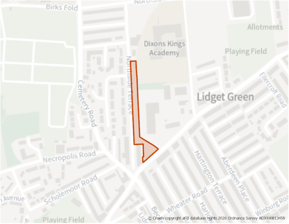
Site Size (ha) Gross: 0.49
Proposed Land Use: Housing
Minimum Development Capacity (Dwellings): 22
Site Type: Greenfield
Ward: Great Horton
Settlement: Bradford South West
Ownership: Private
Delivery Timescale: Long 2035+ (11+)
Site Specific Requirements:
Design Principles
- The site is a parcel of greenfield land within an urban area predominantly comprising residential and commercial uses.
- The site is allocated for residential development. Development should provide a minimum of 15 dwellings as part of a high-quality built environment in line with Policies ST4 and DS1, at a net density of 35 dph in line with Policy HO2. This should include affordable housing (in line with Policy HO4) and an appropriate mix of dwellings (in line with Policy HO3 and having due regard to relevant housing needs, evidence and the character of the area).
Site Access, Highways and Transport
- The site is open and fronts Legrams Lane and Northside Terrace. Legrams Lane is a main arterial road intersecting with the A6177 Bradford Outer Ring Road. New access would lead to Northside Terrace where there are footways and street lighting; dropped footway crossings will be required and implementation of adequate visibility splays. Early engagement with the Council’s transport and highways team is recommended, to understand and mitigate against transport implications for development of the site.
- High Frequency Bus Network service bus stops are located immediately adjacent to the site, providing direct access to Bradford City Centre and Shipley. Development will be required to optimise pedestrian connectivity to the network.
Flooding, Water and Drainage
- The site is in Flood Zone 1. There is a risk of groundwater flooding to both surface and subsurface assets. Groundwater may emerge at significant rates and has the capacity to flow overland and/or pond within any topographic low spots. Development will be expected to be served by acceptable drainage infrastructure based on SuDS principles in line with Policy CR4.
Natural and Historic Environment
- The site is within the setting of a number of Grade II Listed Buildings: Coach House 226 Legrams Lane to the east, and a row of terraces 2-24 Club Street to the west. There are also numerous other Grade II Listed Buildings within the vicinity.
- The design of any development proposal will need to respect the character and setting of nearby heritage assets.
Environmental Protection
- Development layout must mitigate resident exposure to road emissions and demonstrate that site-generated traffic will not worsen air quality along the nearby NO2 30+ corridor on Legrams Lane and at the junction with Cemetery Road.
Open Space and Green / Blue Infrastructure
- Open space should be provided in line with Policy NE2, having regards to the standards set out in Appendix 11. The Open Space Assessment indicates that in Bradford South West there is a need for increased provision of Natural and Semi-natural Greenspace, Outdoor Sports, Parks and Provision for Children.
- The northern portion of the site lies within a strategic Green Infrastructure Corridor. The entire site is within an area of low provision and high need for green and blue infrastructure. Development proposals should focus on carefully designed green and blue infrastructure to contribute towards site specific issues, such as flood mitigation and urban cooling.
- The layout of any future development should integrate the green infrastructure corridor into its design framework, ensuring that boundary treatments protect existing urban wildlife connectivity and foraging lines, supported by a site-specific ecological assessment.
- On-site enhancements should be prioritised to strengthen the Green Infrastructure network, utilising landscape margins and sustainable design features to meet BNG targets.
Infrastructure Requirements
- Proportionate contributions to community infrastructure will be required, where appropriate, in line with Policies ID1 and ID2, and having regard to the Local Infrastructure Plan.
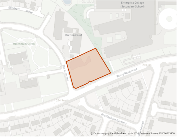
Site Size (ha) Gross: 0.32
Proposed Land Use: Housing
Minimum Development Capacity (Dwellings): 40
Site Type: PDL
Ward: Royds
Settlement: Bradford South West
Ownership: Private
Delivery Timescale: Short 2025- 2030 (1-5)
Site Specific Requirements:
Design Principles
- The site is open land constituting PDL. The site was home to the form Beacon Hotel and has since been cleared. The surrounding area is predominantly residential, with community and educational facilities.
- The site is allocated for residential development. Development should provide a minimum of 40 dwellings as part of a high-quality built environment in line with Policies ST4 and DS1, at a net density of 40 dph in line with Policy HO2. This should include affordable housing (in line with Policy HO4) and an appropriate mix of dwellings (in line with Policy HO3 and having due regard to relevant housing needs, evidence and the character of the area).
Site Access, Highways and Transport
- The site is open and is located on the junction of Reevy Road West and The Crescent. Access to the site would be feasible from The Crescent, subject to the achievement of acceptable gradients, and will need to include the incorporation of dropped footway crossings and implementation of adequate visibility splays. Early engagement with the Council’s transport and highways team is recommended, to understand and mitigate against transport implications for development of the site.
- High Frequency Bus Network service bus stops are located immediately adjacent to the site, providing direct access to Bradford City Centre and Shipley. Development will be required to optimise pedestrian connectivity to the network.
Flooding, Water and Drainage
- The site is in Flood Zone 1. There is a risk of groundwater flooding to subsurface assets, though surface manifestation of groundwater is unlikely. Development will be expected to be served by acceptable drainage infrastructure based on SuDS principles in line with Policy CR4.
Natural and Historic Environment
- A Bat Alert Area is located 120m north. There are no other natural environment designations to consider.
- There are no designated heritage assets within the vicinity to consider. The design of any development proposal will need to respect the character of the area.
Environmental Protection
- There is a potential legacy mine entry shaft located at the south-eastern corner of the site. Whilst the site is within a low-risk area for former coal mining activity, any future planning application will still require the submission of a detailed Coal Mining Risk Assessment to establish and mitigate for any issues relating to the site’s former use.
- The site was developed as a public house/hotel in the late 1960s/1970s, which has recently been demolished and the materials used to create a bund in the west of the site. Any planning application will need to be accompanied by an intrusive investigation detailed report, Hazardous Ground Gas Risk Assessment and Contamination Remediation Statement.
- Buttershaw Business and Enterprise Collage and The Ridge Medical Practice are sensitive air quality receptors nearby to the site. Any future planning application will need to be accompanied by a site-specific construction dust management plan.
Open Space and Green / Blue Infrastructure
- Open space should be provided in line with Policy NE2, having regards to the standards set out in Appendix 11. The Open Space Assessment indicates that in Bradford South West there is a need for increased provision of Natural and Semi-natural Greenspace, Outdoor Sports, Parks and Provision for Children.
- The site is identified as being within an area of low provision and low need for green and blue infrastructure. However, development in this location may increase the need going forward, therefore development proposals should focus on creation of new green and blue infrastructure.
Infrastructure Requirements
- Proportionate contributions to community infrastructure will be required, where appropriate, in line with Policies ID1 and ID2, and having regard to the Local Infrastructure Plan.
Planning Permission
- A detailed planning application is currently pending for this site for construction of a part-3-part-4 storey residential development comprising of 40 apartments with parking and landscaping, which may be determined before the Local Plan is adopted.
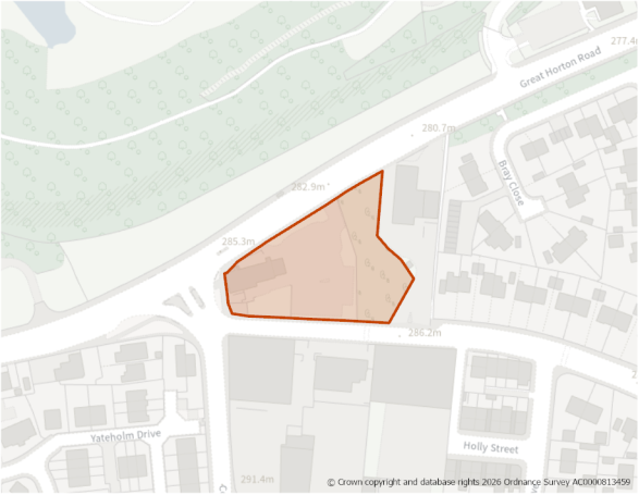
Site Size (ha) Gross: 0.40
Proposed Land Use: Housing
Minimum Development Capacity (Dwellings): 14
Site Type: PDL
Ward: Royds
Settlement: Bradford South West
Ownership: Mixed
Delivery Timescale: Long 2035+ (11+)
Site Specific Requirements:
Design Principles
- The site is PDL comprising the former Hare and Hounds public house – now demolished and the site cleared. The surrounding area is a mix of predominantly residential and industrial/commercial, with Horton Bank Country Park directly opposite.
- The site is allocated for residential development. Development should provide a minimum of 20 dwellings as part of a high-quality built environment in line with Policies ST4 and DS1, at a net density of 35 dph in line with Policy HO2. This should include affordable housing (in line with Policy HO4) and an appropriate mix of dwellings (in line with Policy HO3 and having due regard to relevant housing needs, evidence and the character of the area).
- Any development scheme should ensure the long-term viability of the on-site Listed Building.
Site Access, Highways and Transport
- The site is located at the junction with the A647 Great Horton Road/Highgate Road, Beacon Road and Cooper Lane. Vehicular access to the on-site car park is via Great Horton Road, with pedestrian access from Cooper Lane, where there are two-stage puffin crossings across the busy intersection.
- High Frequency Bus Network service bus stops are located immediately adjacent to the site, providing direct access to Bradford City Centre, Shipley and Halifax. Development will be required to optimise pedestrian connectivity to the network.
- The nearest bus stop on Great Horton Road is located partly across the vehicular access to the site. Repositioning the bus stop has previously been considered and discounted as unfeasible.
- Any development will require the delivery of necessary highway safety improvements at the junction, including implementation of adequate visibility splays, installation of a yellow junction box at the vehicular access point, installation of a pedestrian traffic island to the east of the vehicular entrance, a right turn land in the middle of the carriageway for vehicles travelling from the west, and the implementation of parking restrictions along Great Hortn Road.
- Early engagement with the Council’s transport and highways team is recommended, to understand and mitigate against transport implications for development of the site.
Flooding, Water and Drainage
- The site is in Flood Zone 1. There is a risk of groundwater flooding to subsurface assets, though surface manifestation of groundwater is unlikely. Development will be expected to be served by acceptable drainage infrastructure based on SuDS principles in line with Policy CR4.
Natural and Historic Environment
- The site is located in Zone C of the South Pennine Moors SPA/SAC 7km recreational pressure impact zone. It is situated within a designated Bat Alert Area and lies directly adjacent to Horton Bank Country Park (15m to the north, which is an identified Local Wildlife Site and Woodland Habitat Network (comprising deciduous woodland).
- Development must ensure that on-site amenity space includes ecological enhancements to deliver meaningful habitat creation to meet BNG requirements. The site is located within a bat alert area. Planning applications must be accompanied by a bat survey, and the final development layout should incorporate integrated bat boxes and features to provide long-term habitat enhancements.
- Due to the physical separation caused by the main road to the north, development layout must prioritise a robust perimeter landscaping scheme. Proposals must retain high-quality boundary trees where practicable and deploy new, targeted perimeter tree planting to soften the street-frontage transition towards Horton Bank Country Park.
- The former Hare and Hounds building is a Grade II Listed Building. The site is also within the setting of the Grade II Listed Two Portals to Mill at Mercon House on the Great Horton Industrial Estate to the south.
- There are opportunities to extend the rear of the Hare and Hounds, although all works must be designed in a way which maintains the legibility of the designated asset, including exploring all feasible ways of improving and enhancing the significance of the building. The design of any development proposal as a will need to respect the character and setting of on-site and nearby heritage assets, as well as the character of the area.
Environmental Protection
- Development layout must mitigate resident exposure to road emissions and demonstrate that site-generated traffic will not worsen air quality along the nearby NO2 30+ corridor on Highgate Road and at the junction with Great Horton Road.
Open Space and Green / Blue Infrastructure
- Open space should be provided in line with Policy NE2, having regards to the standards set out in Appendix 11. The Open Space Assessment indicates that in Bradford South West there is a need for increased provision of Natural and Semi-natural Greenspace, Outdoor Sports, Parks and Provision for Children.
Landscape
- The site’s eastern section comprises a thicket of mature trees and undergrowth. Any future development should be accompanied by a high-quality landscaping scheme, which seeks to improve the visual amenities of the site and retain as many trees as practicable. Where the loss of trees is unavoidable, on-site planting of new trees of an appropriate species and location will be required.
- In the event that development requires the removal of shrubs/undergrowth on site, the proposed landscaping design will need to account for any loss of ecological value as part of meeting the mandatory BNG target, as well as the visual amenities of the site.
- A detailed landscape assessment will be required to demonstrate how the development aligns with guidance set out in the Council’s Landscape Character Assessment SPD.
Infrastructure Requirements
- Proportionate contributions to community infrastructure will be required, where appropriate, in line with Policies ID1 and ID2, and having regard to the Local Infrastructure Plan.
Planning Permission
- It is noted that the site has planning permission for a convenience retail store and separate commercial unit, with associated access, parking and landscaping (25/03007/FUL) granted in October 2025. Notwithstanding this, the site has been assessed and identified as being suitable for a residential-led development.
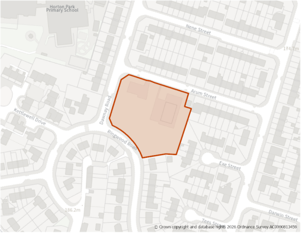
Site Size (ha) Gross: 0.49
Proposed Land Use: Housing
Minimum Development Capacity (Dwellings): 22
Site Type: PDL
Ward: Little Horton
Settlement: Bradford South West
Ownership: Private
Delivery Timescale: Medium 2030-2035 (6-10)
Site Specific Requirements:
Design Principles
- The site is PDL and comprises the former - now demolished - community centre, open grassed area, and MUGA.
- The site is allocated for residential development. Development should provide a minimum of 22 dwellings as part of a high-quality built environment in line with Policies ST4 and DS1, at a net density of 50 dph, in line with Policy HO2. This should include affordable housing (in line with Policy HO4) and an appropriate mix of dwellings (in line with Policy HO3 and having due regard to relevant housing needs, evidence and the character of the area).
- Any future housing layout must position dwellings away from the south-eastern corner to ensure adequate separation distances from the substation and include a high-quality landscaping scheme which screens views and considers connectivity to the adjacent Green Infrastructure Corridor.
Site Access, Highways and Transport
- The site is located at the junction with Ringwood Road/Dawnay Road and Dawnay Road/Arum Street. There is no existing vehicular access; pedestrian access is via Arum Road.
- New vehicular access to the site will need to include the incorporation of dropped footway crossings and implementation of adequate visibility splays. Early engagement with the Council’s transport and highways team is recommended, to understand and mitigate against transport implications for development of the site.
- The site is located within 400m of High Frequency Bus Network service bus stops providing direct access to Bradford City Centre and Halifax. Development will be required to optimise pedestrian connectivity to the network
Flooding, Water and Drainage
- The site is in Flood Zone 1. There is a risk of groundwater flooding to both surface and subsurface assets, with the possibility of groundwater emerging at the surface locally. Development will be expected to be served by acceptable drainage infrastructure based on SuDS principles in line with Policy CR4.
Natural and Historic Environment
- The site does not sit within any natural environment designations but is within 20m of a Bat Alert Area to the north-west. Any future layout must incorporate sensitive design and boundary treatments to prevent negative edge-effects and support wider ecological connectivity, as part of BNG commitments.
- The southern tip of the site is within the setting of a Grade II terrace to the south on Quaker Lane. The design of any development proposal as a will need to respect the character and setting of nearby heritage assets, as well as the character of the area.
Environmental Protection
- This site is located within the Clean Air Zone and development must be in accordance with the requirements set out in Policy CR1.
- An operational substation is located at the north-eastern corner of the site. Any future housing layout must position dwellings away from the south-eastern corner to ensure adequate separation distances, to safeguard future residents from any localised noise or visual intrusion.
Open Space and Green / Blue Infrastructure
- Open space should be provided in line with Policy NE2, having regards to the standards set out in Appendix 11. The Open Space Assessment indicates that in Bradford South West there is a need for increased provision of Natural and Semi-natural Greenspace, Outdoor Sports, Parks and Provision for Children.
- The site currently includes a MUGA within an area of existing open space. Given identified deficiencies in play and recreation provision in the surrounding area, development should eek to retain and integrate the MUGA within the scheme. Where retention is demonstrated not to be feasible, appropriate replacement provision should be made in an accessible location serving the local community, in line with Policy NE2 and the standard set out in Appendix 11.
- The site is located within 55m of a Green Infrastructure Corridor to the west. It is identified as being within an area of low provision and low need for green and blue infrastructure. However, development in this location may increase the need going forward, therefore development proposals should focus on creation of new green and blue infrastructure, including enhancements and connectivity to the existing Green Infrastructure Corridor.
- The site lies within the Bradford City Centre Opportunity Area, as identified in the Green and Blue Infrastructure Strategy (GBIS). The strategy should be consulted to identify opportunities for incorporating measures within the development that enhance the quality of, and connectivity to, the green and blue infrastructure network in this area.
Landscape
- Any future development must incorporate a robust, dense boundary planting buffer to screen the adjacent substation. Any development should give due consideration to the guidance set out in the Council’s Landscape Character Assessment SPD.
Infrastructure Requirements
- Proportionate contributions to community infrastructure will be required, where appropriate, in line with Policies ID1 and ID2, and having regard to the Local Infrastructure Plan.
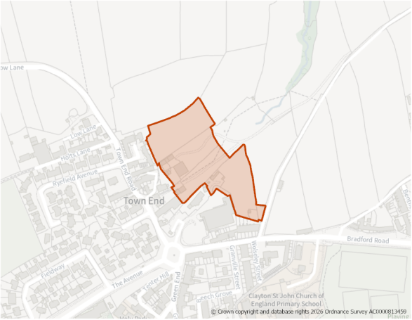
Site Size (ha) Gross: 1.56
Proposed Land Use: Housing
Minimum Development Capacity (Dwellings): 49
Site Type: Mixed
Ward: Clayton & Fairweather Green
Settlement: Bradford South West
Ownership: Mixed
Delivery Timescale: Long 2035+ (11+)
Site Specific Requirements:
Design Principles
- The site is open greenfield land in an edge-of-settlement location.
- Development should provide a minimum of 49 dwellings as part of a high-quality built environment in line with Policies ST4 and DS1, at a net density of 35 dph, in line with Policy HO2. This should include affordable housing (in line with Policy HO4) and an appropriate mix of dwellings (in line with Policy HO3 and having due regard to relevant housing needs, evidence and the character of the area).
- Development should be of an appropriate and sympathetic scale and design, incorporating substantial landscaped buffer, and preserving, where possible, views into the Conservation Area and outwards towards the wider countryside. Design and layout should respond positively to the green infrastructure within the site, the adjacent SPA/SAC, and on-site flood risk constraints.
- Enhancements to the surrounding Green Belt land should be made, including improving connections to offer opportunities for residents to access the countryside.
Site Access, Highways and Transport
- The site would require a new access point, which would likely be via Deep Lane/Bradford Road. Access to the site is dependent on third-party land parcels and must be comprehensively secured and delivered via the adjoining site H1270 (Land off Buckingham Crescent), connecting the site to the wider strategic highway network.
- High Frequency Bus Network services are located within 400m of the site, connecting Clayton with Bradford City Centre.
- Any development would require the delivery of necessary highway safety and connectivity improvements, including the implementation of high-quality pedestrian and cycle linkages to ensure full permeability, the establishment of safe and adequate visibility splays at egress points, and the delivery of direct pedestrian routing from the site to nearby transit stops.
- Early engagement with the Council’s transport and highways team, as well as the developers of the adjoining site, is recommended to understand and mitigate against transport implications, and to ensure a coordinated infrastructure delivery strategy for the development of the site.
Flooding, Water and Drainage
- The site is in Flood Zone 1. There is a risk of groundwater flooding to both surface and subsurface assets. Groundwater may emerge at significant rates and has the capacity to flow overland and/or pond within any topographic low spots. The central area of the site is subject to surface water risk. Development will be expected to be served by acceptable drainage infrastructure based on SuDS principles in line with Policy CR4.
Natural and Historic Environment
- The site lies within Zone C (Recreational Pressure) of the South Pennine Moors SPA/SAC – Residential development resulting in a net increase in dwellings will be required to mitigate any recreational pressure on the SPA/SAC caused by such development in accordance with the South Pennine Moors SPD and Policy NE3.
- The site directly adjoins Clayton Conservation Area to the west and is within the setting of a high number of Grade II Listed Buildings along its western and southern edge. The Council’s Heritage Impact Assessment advises that limited development of this site may be considered acceptable if the key existing open space is retained.
- Development should be of a low density and carefully designed to minimise adverse impacts on the Clayton Conservation Area and associated Listed Buildings.
- The site is located within a bat alert area. An ecological survey will be required as part of any planning application to establish the extent/impacts as well as to identify appropriate mitigation.
Environmental Protection
- The site is partly within the 150m buffer of a former landfill site. A Land Contamination Assessment – Phase 1 Report will be required as part of any planning application.
Open Space and Green / Blue Infrastructure
- Open space should be provided in line with Policy NE2, having regards to the standards set out in Appendix 11. The Open Space Assessment indicates that in Bradford South West there is a need for increased provision of Natural and Semi-natural Greenspace, Outdoor Sports, Parks and Provision for Children.
- The majority of the site is within the Pitty and Clayton Beck Green Infrastructure Corridor and is within a Bat Alert Area. The layout of any future development must retain an undeveloped, unlit green infrastructure buffer to protect bat foraging routes, and link to the existing habitat corridor. Ecological enhancements should be prioritised on-site, utilising and retain the key, existing open space buffer on the northern edge of the allocation to deliver meaningful habitat creation to meet BNG requirements.
- The site is partially within an area of medium provision and low need for green and blue infrastructure. However, development in this location may increase the need going forward, therefore development proposals should focus on creation of new green and blue infrastructure, including enhancements and connectivity to the existing Green Infrastructure Corridor.
Landscape
- The site is located within the Clayton Urban Edge Wooded Valleys and Slopes Landscape Character area/type (E1). The Council's Landscape Sensitivity Assessment has assessed the site as having an overall medium sensitivity to change. The eastern half of the site, where the historic field pattern has been lost to previous land use, is less sensitive to change.
- A comprehensive Landscape Impact Assessment must accompany any planning application. The site layout, building heights and material palettes must demonstrate how they mitigate visual impacts on the Clayton Urban Edge Wooded Valleys and Slopes landscape character area, responding directly to its baseline medium sensitivity to change. Development should be focused within the eastern half of the site allocation, noting too the Green Belt designation in the eastern-most portion of the site, whose openness must be retained. The layout of any development must actively protect, reinforce or mirror any surviving historic field patterns across the remaining, more sensitive tranches of the site.
- Any development should give due consideration to the guidance set out in the Council’s Landscape Character Assessment SPD.
Green Belt
- The eastern-most portion of the site is designated Green Belt. Development should be redirected from this section of the site and demonstrate that the openness of the on-site and adjacent Green Belt is protected.
Infrastructure Requirements
- Proportionate contributions to community infrastructure will be required, where appropriate, in line with Policies ID1 and ID2, and having regard to the Local Infrastructure Plan.
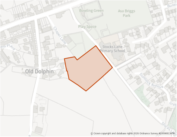
Site Size (ha) Gross: 0.83
Proposed Land Use: Housing
Minimum Development Capacity (Dwellings): 26
Site Type: Greenfield
Ward: Queensbury
Settlement: Bradford South West
Ownership: Private
Delivery Timescale: Long 2035+ (11+)
Site Specific Requirements:
Design Principles
- The site is open greenfield land in an edge-of-settlement location.
- Development should provide a minimum of 26 dwellings as part of a high-quality built environment in line with Policies ST4 and DS1, at a net density of 35 dph, in line with Policy HO2. This should include affordable housing (in line with Policy HO4) and an appropriate mix of dwellings (in line with Policy HO3 and having due regard to relevant housing needs, evidence and the character of the area).
- Enhancements to the surrounding Green Belt land should be made, including improving connections to offer opportunities for residents to access the countryside.
Site Access, Highways and Transport
- The site is located on Stocks Lane, directly opposite Stocks Lane Primary School. The nearest High Frequency Bus Network service bus stop is located on Highgate Road/Cooper Lane, providing direct access to Bradford City Centre and Halifax.
- Vehicular access to the site must be achieved via Stocks Lane. The proximity of the school will require sensitive transport planning. Any layout design will require a full Transport Assessment to determine safe access parameters, including Swept Path Analysis to demonstrate that emergency and refuse vehicles can safely turn and pass. Development will be required to deliver necessary highway safety and active travel improvements, including adequate visibility splays, traffic calming, and safe walking routes to the school and nearest available bus stop on Highgate Road/Cooper Lane.
- Early engagement with the Council’s transport and highways team and the school is recommended, to understand and mitigate against transport implications for development of the site.
Flooding, Water and Drainage
- The site is in Flood Zone 1. There is a risk of flooding to subsurface assets in the eastern section of the site but surface manifestation of groundwater is unlikely. Development will be expected to be served by acceptable drainage infrastructure based on SuDS principles in line with Policy CR4.
Natural and Historic Environment
- The site lies within Zone C (Recreational Pressure) of the South Pennine Moors SPA/SAC – Residential development resulting in a net increase in dwellings will be required to mitigate any recreational pressure on the SPA/SAC caused by such development in accordance with the South Pennine Moors SPD and Policy NE3.
- The site is in a Bat Alert Area. An Ecology Survey will be required at planning stage. Early engagement with the Council’s Biodiversity Officer is recommended.
- There are no heritage assets on-site or within the immediate vicinity to consider. The design of any development proposal will need to respect the character of the area.
Environmental Protection
- The site is within a bat alert area. Any future application must be supported by a bat survey, and demonstrate consideration of foraging routes, exploring links to the adjacent Green Infrastructure Network to the west.
Open Space and Green / Blue Infrastructure
- Open space should be provided in line with Policy NE2, having regards to the standards set out in Appendix 11. The Open Space Assessment indicates that in Bradford South West there is a need for increased provision of Natural and Semi-natural Greenspace, Outdoor Sports, Parks and Provision for Children.
- The site is located within 70m of a Green Infrastructure Network to the west. Ecological records indicate the site contains a mix of acid, calcareous, neutral and improved grassland. The site layout of any future development must demonstrate how it protects the nearby Green Infrastructure Network from adverse impacts, maintains ecological connectivity, and fulfils statutory BNG obligations through targeted habitat preservation, and where possible, enhancement.
- The site is identified as being within an area of low provision and low need for green and blue infrastructure. However, development in this location may increase the need going forward, therefore development proposals should focus on creation of new green and blue infrastructure, including enhancements and connectivity to the existing Green Infrastructure Corridor.
- The site is identified in the LNRS with the preferred measure B2_M04: Significantly boost the quality of existing blue and green habitat corridors and stepping stones within urban spaces to attract different native plants and animals, and more of them. It is recommended that development incrementally boosts biodiversity in urban communal areas by replacing hedgerows with native mixed varieties and creating and incorporating freshwater ponds.
Landscape
- The site is located within the Thornton, Queensbury and Wilsden Mixed Upland Pasture Landscape Character Area/Type (E1) and is designated as Mixed Upland Pasture. Any development, layout, building heights and material choices will need to be sensitively designed to respect the open, rural characteristics of this upland pasture setting. A detailed landscape assessment will be required to demonstrate how the development aligns with guidance st out in the Council’s Landscape Character Assessment SPD.
Green Belt (and Golden Rules)
- This site has been removed from the Green Belt. Development on the site should be consistent with the “Golden Rules” set out in the NPPF in relation to affordable housing, necessary improvements to infrastructure and accessible green space provision.
Infrastructure Requirements
- Proportionate contributions to community infrastructure will be required, where appropriate, in line with Policies ID1 and ID2, and having regard to the Local Infrastructure Plan.
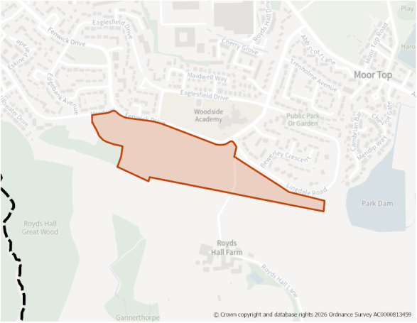
Site Size (ha) Gross: 7.53
Proposed Land Use: Housing
Minimum Development Capacity (Dwellings): 198
Site Type: Greenfield
Ward: Royds
Settlement: Bradford South West
Ownership: Mixed
Delivery Timescale: Long 2035+ (11+)
Site Specific Requirements:
Design Principles
- The site is non-designated greenfield land in an edge-of-settlement location. Development should provide a minimum of 198 dwelling as part of a high-quality built environment in line with Policies ST4 and DS1, at a net density of 35 dph in line with Policy HO2. This should include affordable housing (in line with Policy HO4) and an appropriate mix of dwellings (in line with Policy HO3 and having due regard to relevant housing needs, evidence and the character of the area).
Site Access, Highways and Transport
- Access to the site is currently via Royds Hall Lane, which intersects the site. Any new access required would need to be agreed with the Councils Highways Officers.
- The site is located within 400m of High Frequency Bus Network service bus stops providing direct access to Bradford City Centre and Halifax. Development will be required to optimise pedestrian connectivity to the network on Highgate Road.
Flooding, Water and Drainage
- The site is in Flood Zone 1. Some isolated parts of the site are subject to a risk of groundwater flooding to both surface and subsurface assets. There is the possibility of groundwater emerging at the surface locally. Development will be expected to be served by acceptable drainage infrastructure based on SuDS principles in line with Policy CR4.
Natural and Historic Environment
- The western edge of the site is within the 25m buffer zone of North Brow Wood ancient protected woodland, and directly adjoins Judy Woods, a Local Wildlife Site of deciduous woodland. Development will need to demonstrate that the integrity of the woodland is protected and further planting of native species will be required to strengthen this boundary. There is also a tree subject to a TPO on the northern boundary, which will require protection.
- Much of the site is within a Bat Alert Area. Any future application must be supported by a bat survey, and demonstrate consideration of foraging routes, exploring links to the existing habitat site to the west.
- Ecological records indicate the site contains a mix of acid, calcareous, neutral and improved grassland. The site layout of any future development must demonstrate how it protects the nearby green habitat networks from adverse impacts, maintains ecological connectivity, and fulfils statutory BNG obligations through targeted habitat preservation, and where possible, enhancement.
- Grade II* Listed Royds Hall Farm House and associated buildings lie approx.100m to the south. The design of any development proposal will need to respect the character and setting of designated heritage assets, having regard for the semi-rural nature of the application site.
Environmental Protection
- The site is partially within a Development High Risk Area for coal mining, indicating that it contains one or more recorded former related features at surface or shallow depth. A Coal Mining Risk Assessment (CMRA) will be required as part of any planning application.
Open Space and Green / Blue Infrastructure
- Open space should be provided in line with Policy NE2, having regards to the standards set out in Appendix 11. The Open Space Assessment indicates that in Bradford South West there is a need for increased provision of Natural and Semi-natural Greenspace, Outdoor Sports, Parks and Provision for Children.
- The site is partially within an area of low provision and high need for green and blue infrastructure. Development proposals should focus on carefully designed green and blue infrastructure to contribute towards site specific issues, such as flood mitigation and urban cooling.
Landscape
- The site is located within the Urban Edge Wooded Valleys and Slopes Landscape Character Area/Type (H4). Council’s Landscape Sensitivity Assessment indicates that the site has an overall medium sensitivity to change.
- A comprehensive Landscape Impact Assessment must accompany any planning application. Development should be low density of an appropriate and sensitive design that positively integrates and soften the existing settlement edge. Tree planting on boundaries of the site and throughout the site would provide a visual and ecological connection to existing woodland. Focusing development on the lower slopes or less prominent parts of the site would minimize the impact on wider views across the valley.
- Any development should give due consideration to the guidance set out in the Council’s Landscape Character Assessment SPD.
Other Constraints
- The site is crossed from north-west to south-east by overhead high voltage electricity transmission line. Development should include a strategy for responding to the National Grid Overhead Cable Route present within the site which demonstrates how the National Grid Design Guide and Principles have been as part of the design and layout and how the impact of the assets has been reduced through good design. Overhead powerlines will need to be rerouted below ground.
Infrastructure Requirements
- Proportionate contributions to community infrastructure will be required, where appropriate, in line with Policies ID1 and ID2, and having regard to the Local Infrastructure Plan.
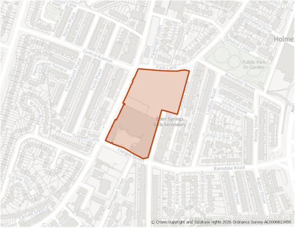
Site Size (ha) Gross: 1.79
Proposed Land Use: Housing
Minimum Development Capacity (Dwellings): 483
Site Type: Mixed
Ward: Little Horton
Settlement: Bradford South West
Ownership: Private
Delivery Timescale: Long 2035+ (11+)
Site Specific Requirements:
Design Principles
- The site is in an urban location and consists of Brigella Mills and open land to the north.
- Development should provide a minimum of 483 dwelling as part of a high-quality built environment in line with Policies ST4 and DS1, at a net density of 300 dph in line with Policy HO2. This should include affordable housing (in line with Policy HO4) and an appropriate mix of dwellings (in line with Policy HO3 and having due regard to relevant housing needs, evidence and the character of the area).
Site Access, Highways and Transport
- Site access is currently via Clarges Street. Direct mitigation will be needed to manage conflicts with the drop-off/pick-up activity associated with the immediately adjacent Eden Springs Secondary School and Mosque on Dorset Street. Early engagement with the Council’s transport and highways team and the school is recommended, to understand and mitigate against transport implications for development of the site.
- The site is within close proximity to High Frequency Bus Network service bus stops, providing direct access to Bradford City Centre and Halifax. Development will be required to optimise pedestrian connectivity to the network on Highgate Road.
Flooding, Water and Drainage
- The north eastern section of the site is at risk of groundwater flooding to both surface and subsurface assets. There is the possibility of groundwater emerging at the surface locally. Development will be expected to be served by acceptable drainage infrastructure based on SuDS principles in line with Policy CR4.
Natural and Historic Environment
- Ecological records indicate that the northern portion of the site comprises fen, marsh and swamp habitat. Development layout must actively seek to retain and protect the highest-value wetland features where feasible, and fulfil statutory BNG obligations through targeted habitat preservation, and where possible, enhancement.
- The site is identified in the LNRS with the preferred measure B3_M02: The enhancement (rather than replacement) of existing habitats on some areas of brownfield so they become high-quality, diverse, wildlife-rich spaces or urban parks (taking site allocations into account). This will help species that rely on brownfield habitats, such as the dingy skipper. Development design should allow significant areas to develop naturally; depending on how permeable the site is, this will also help to control water during excess rainfall.
- The Council’s Heritage Impact Assessment identified the on-site buildings comprising Briggella Mills as having clear heritage merit. Development is expected to retain and convert the buildings for residential uses, ensuring that any scheme retains the key architectural features and industrial character of the original mill complex.
- The design of any development proposal will need to respect the character and setting of non-designated heritage assets and have regard to the character of the area.
Environmental Protection
- This site is located within the Clean Air Zone and development must be in accordance with the requirements set out in Policy CR1.
- Development layout must mitigate resident exposure to road emissions and demonstrate that site-generated traffic will not worsen air quality along the nearby NO2 30+ corridor on Little Horton Lane.
Open Space and Green / Blue Infrastructure
- Open space should be provided in line with Policy NE2, having regards to the standards set out in Appendix 11. The Open Space Assessment indicates that in Bradford South West there is a need for increased provision of Natural and Semi-natural Greenspace, Outdoor Sports, Parks and Provision for Children.
- The site is within a green and blue infrastructure focus area. Development must actively contribute to the connectivity, quality and biodiversity of the surrounding urban ecosystem loop. Proposals will be required to incorporate space-efficient urban greening measures, including street tree planting along the street frontages to enhance the local canopy cover.
- The site is partially within an area of low provision and high need for green and blue infrastructure. Development proposals should focus on carefully designed green and blue infrastructure to contribute towards site specific issues, such as flood mitigation and urban cooling.
Infrastructure Requirements
- Proportionate contributions to community infrastructure will be required, where appropriate, in line with Policies ID1 and ID2, and having regard to the Local Infrastructure Plan.
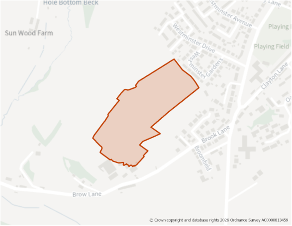
Site Size (ha) Gross: 5.21
Proposed Land Use: Housing
Minimum Development Capacity (Dwellings): 137
Site Type: Greenfield
Ward: Clayton & Fairweather Green
Settlement: Bradford South West
Ownership: Private
Delivery Timescale: Long 2035+ (11+)
Site Specific Requirements:
Design Principles
- The site is open greenfield land in an edge-of-settlement location.
- The site is allocated for residential-led development and should provide a minimum of 137 dwellings as part of a high-quality built environment in line with Policies ST4 and DS1, at a net density of 35 dph in line with Policy HO2. T This should include affordable housing (in line with Policy HO4) and an appropriate mix of dwellings (in line with Policy HO3 and having due regard to relevant housing needs, evidence and the character of the area).
Site Access, Highways and Transport
- There is currently no direct access to the site, which will need to be resolved, but could be provided through adjacent undeveloped land. Access provision would need to be agreed with the Councils Highways Officers and early engagement is recommended.
- The site is within close proximity to High Frequency Network bus stops on Thornton Road linking Thornton to Bradford City Centre. Development will be required to optimise pedestrian connectivity to the network on Thornton Road.
Flooding, Water and Drainage
- Across the site there is a risk of groundwater flooding to both surface and subsurface assets, and the possibility of groundwater emerging at the surface locally. Development will be expected to be served by acceptable drainage infrastructure based on SuDS principles in line with Policy CR4.
Natural and Historic Environment
- The site lies within Zone C (Recreational Pressure) of the South Pennine Moors SPA/SAC – Residential development resulting in a net increase in dwellings will be required to mitigate any recreational pressure on the SPA/SAC caused by such development in accordance with the South Pennine Moors SPD and Policy NE3.
- There are a number of Listed Buildings within the wider vicinity. The design of any development proposal will need to respect the character and setting of designated and non-designated heritage assets, having regard to the semi-rural nature of the application site.
Environmental Protection
- The site partly contains a former landfill site. A Land Contamination Assessment – Phase 1 Report will be required as part of any planning application due determining any potential impacts. Impacts should be addressed in line with Policy CR2.
Open Space and Green / Blue Infrastructure
- Open space must be provided in line with Policy NE2, having regard to the standards set out Appendix 11, and satisfying the ‘Golden Rules’ criteria of the NPPF, having due regard to the requirement for new or enhanced publicly-accessible green space. The Open Space Assessment indicates that in Bradford South West there is a need for increased provision of Natural and Semi-natural Greenspace, Outdoor Sports, Parks and Provision for Children.
- The site forms part of the Great Northern Trail and Shibden Green Infrastructure Corridor borders a designated Grassland Habitat Network to the west/south and lies directly adjacent to a regionally significant Wetland Habitat Network corridor running along the southern boundary. Ecological records indicate the site contains a mix of acid, calcareous, neutral and improved grassland.
- The site is identified as being within an area of low provision and low need for green and blue infrastructure. However, development in this location may increase the need going forward, therefore development proposals should focus on creation of new green and blue infrastructure, including enhancements and connectivity to the existing Green Infrastructure Corridor.
- The design and layout of any development should ensure due consideration is given to the site’s Green Infrastructure connectivity and enhancement, and fulfils statutory BNG obligations through targeted habitat preservation, and where possible, enhancement.
Landscape
- The site is located within the Thornton Mixed Upland Pasture Character Area/Type (E1). The Council’s Landscape Sensitivity Assessment identifies that the site has an overall medium sensitivity to change but contains contrasting sensitivity across the site. Much of the interior of the site is of lower sensitivity, but the exposed north-western boundary is highly sensitive due to its elevation, exposure and visibility. Development should be pulled back from the north-western edge and restricted to the lower, well-screened parts of the site to avoid significant visual impacts.
- A comprehensive Landscape Impact Assessment must accompany any planning application. Development should give due consideration to the guidance set out in the Council’s Landscape Character Assessment SPD.
Green Belt (and Golden Rules)
- The site has been removed from the Green Belt. Development on the site should be consistent with the “Golden Rules” set out in the NPPF in relation to affordable housing, necessary improvements to infrastructure and accessible green space provision.
Infrastructure Requirements
- Proportionate contributions to community infrastructure will be required, where appropriate, in line with Policies ID1 and ID2, and having regard to the Local Infrastructure Plan.
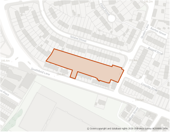
Site Size (ha) Gross: 0.39
Proposed Land Use: Housing
Minimum Development Capacity (Dwellings): 14
Site Type: Greenfield
Ward: Little Horton
Settlement: Bradford South West
Ownership: Other
Delivery Timescale: Long 2035+ (11+)
Site Specific Requirements:
Design Principles
- The site comprises a vacant infill plot within an urban residential area.
- The site is allocated for residential development. Development should provide a minimum of 14 dwellings as part of a high-quality built environment in line with Policies ST4 and DS1, at a net density of 35 dph in line with Policy HO2. This should include affordable housing (in line with Policy HO4) and an appropriate mix of dwellings (in line with Policy HO3 and having due regard to relevant housing needs, evidence and the character of the area).
Site Access, Highways and Transport
- Access is heavily constrained by the existing site frontage onto Quaker Lane, which is currently unmade and lacks a continuous, formal pedestrian footpath. Access improvements will be required including the incorporation of dropped footway crossings, implementation of adequate visibility splays, and of footway widening, where appropriate. Early engagement with the Council’s transport and highways team is recommended, to understand and mitigate against transport implications for development of the site.
- The site is situated within 400 meters of a High Frequency Bus Network via the main Southfield Lane corridor, providing direct links to Bradford City Centre and Halifax. Development will be required to optimise pedestrian connectivity to the network.
Flooding, Water and Drainage
- The site is in Flood Zone 1 and is not considered to be at risk of groundwater or surface flooding. Development will be expected to be served by acceptable drainage infrastructure based on SuDS principles in line with Policy CR4.
Natural and Historic Environment
- Please refer to Open Space and Green/Blue Infrastructure section below.
- The design and layout of any development should ensure due consideration is given to the character of the area.
Environmental Protection
- This site is located within the Clean Air Zone and development must be in accordance with the requirements set out in Policy CR1.
Open Space and Green / Blue Infrastructure
- Open space should be provided in line with Policy NE2, having regards to the standards set out in Appendix 11. The Open Space Assessment indicates that in Bradford South West there is a need for increased provision of Natural and Semi-natural Greenspace, Outdoor Sports, Parks and Provision for Children.
- The site is within a Green Infrastructure Corridor and Green and Blue Infrastructure Focus Area. Development must protect, enhance, and integrate with the network of multifunctional green and blue infrastructure layers, and will be required to incorporate space-efficient urban greening measures into the site design framework.
- The site lies within the Bradford City Centre Opportunity Area, as identified in the Green and Blue Infrastructure Strategy (GBIS). The strategy should be consulted to identify opportunities for incorporating measures within the development that enhance the quality of, and connectivity to, the green and blue infrastructure network in this area.
- The site is within an area of low provision and high need for green and blue infrastructure. Development proposals should focus on carefully designed green and blue infrastructure to contribute towards site specific issues, such as flood mitigation and urban cooling.
Infrastructure Requirements
- Proportionate contributions to community infrastructure will be required, where appropriate, in line with Policies ID1 and ID2, and having regard to the Local Infrastructure Plan.
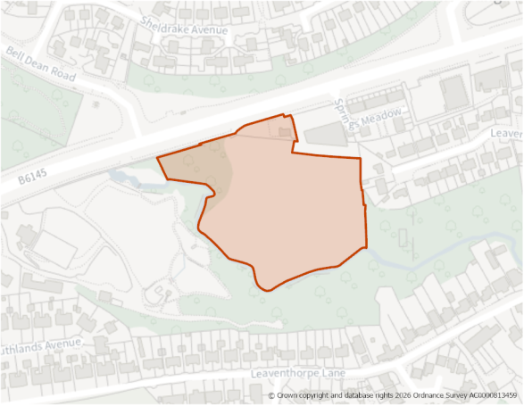
Site Size (ha) Gross: 1.38
Proposed Land Use: Housing
Minimum Development Capacity (Dwellings): 43
Site Type: Greenfield
Ward: Clayton & Fairweather Green
Settlement: Bradford South West
Ownership: Public
Delivery Timescale: Medium 2030-2035 (6-10)
Site Specific Requirements:
Design Principles
- The site comprises an urban fringe greenfield site within an urban residential area.
- The site is allocated for residential development. Development should provide a minimum of 43 dwellings as part of a high-quality built environment in line with Policies ST4 and DS1, at a net density of 30 dph in line with Policy HO3. This should include affordable housing (in line with Policy HO4) and an appropriate mix of dwellings (in line with Policy HO3 and having due regard to relevant housing needs, evidence and the character of the area).
Site Access, Highways and Transport
- Vehicular access is currently restricted by the lack of direct road frontage. A safe, adoptable site access junction configuration must be delivered onto Thornton Road, including the incorporation of dropped footway crossings and implementation of adequate visibility splays. Early engagement with the Council’s transport and highways team is recommended, to understand and mitigate against transport implications for development of the site.
- The site is situated within 400 meters of a High Frequency Bus Network via the main Southfield Lane corridor, providing direct links to Bradford City Centre and Halifax. Development will be required to optimise pedestrian connectivity to the network.
Flooding, Water and Drainage
- The site is in Flood Zone 1 though is bounded by Pitty Beck and is at a high risk of groundwater flooding to both surface and subsurface assets. Groundwater may emerge at significant rates and has the capacity to flow overland and/or pond within any topographic low spots. Development will be expected to be served by acceptable drainage infrastructure based on SuDS principles in line with Policy CR4.
Natural and Historic Environment
- The site is identified in the LNRS with the preferred measure B4_M02. This requires the creation and maintenance of biodiverse-rich habitats along existing and new highways, cycleways and other transport infrastructure (lines of resilient urban trees, buffer strips of successional scrubland, grassland, heathland, wetlands with open mosaic habitats, sustainable urban drainage systems, nature-rich roundabouts, pollinator corridors, hedgerows alongside paths.) The use of native, locally appropriate species is recommended and development should aim to make a real contribution to habitats through maximising area and quality, taking account too of air quality, noise buffering, surface run-off management, accessibility and public safety.
- The site is located within a bat alert area. An ecological survey will be required as part of any planning application to establish the extent/impacts as well as to identify appropriate mitigation.
- The design and layout of any development should ensure due consideration is given to the character of the area.
Environmental Protection
- Development layout must mitigate resident exposure to road emissions and demonstrate that site-generated traffic will not worsen air quality along the nearby NO2 30+ corridor on Thornton Road.
Open Space and Green / Blue Infrastructure
- Open space should be provided in line with Policy NE2, having regards to the standards set out in Appendix 11. The Open Space Assessment indicates that in Bradford South West there is a need for increased provision of Natural and Semi-natural Greenspace, Outdoor Sports, Parks and Provision for Children.
- The site comprises semi-improved pasture and is located within a Green Infrastructure Network and Wildlife Habitat Network. Development must protect, enhance, and integrate with the network of multifunctional green and blue infrastructure layers, and will be required to incorporate space-efficient urban greening measures into the site design framework.
- The boundary interfaces with the Pitty Beck watercourse, which supports UK BAP Notable fish species, and adjoins a Priority Habitats deciduous woodland. A mandatory minimum 30m undeveloped structural landscape buffer zone must be maintained from the brink of Pitty Beck to shield the aquatic ecosystem from domestic edge effects.
- The site is identified as being within an area of medium provision and low need for green and blue infrastructure. However, development in this location may increase the need going forward, therefore development proposals should focus on creation of new green and blue infrastructure, including enhancements and connectivity to the existing Green Infrastructure Corridor and Wild Habitat Network.
Landscape
- The western section of the site contains an established cluster of non-protected mature trees associated with the Pitty Beck riparian corridor. The layout of any future development must ensure the full retention and protection of the woodland grouping, ensuring no residential plots encroach upon the established tree roots or long-term canopy spread.
Infrastructure Requirements
- Proportionate contributions to community infrastructure will be required, where appropriate, in line with Policies ID1 and ID2, and having regard to the Local Infrastructure Plan.
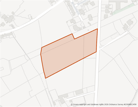
Site Size (ha) Gross: 1.72
Proposed Land Use: Housing
Minimum Development Capacity (Dwellings): 54
Site Type: Greenfield
Ward: Clayton & Fairweather Green
Settlement: Bradford South West
Ownership: Private
Delivery Timescale: Long 2035+ (11+)
Site Specific Requirements:
Design Principles
- The site is open greenfield land in an edge-of-settlement location.
- The site is allocated for residential-led development and should provide a minimum of 54 dwellings as part of a high-quality built environment in line with Policies ST4 and DS1, at a net density of 35 dph in line with Policy HO2. This should include affordable housing (in line with Policy HO4) and an appropriate mix of dwellings (in line with Policy HO3 and having due regard to relevant housing needs, evidence and the character of the area).
- A sensitive design and layout will be required taking into consideration the site’s location on the edge of the settlement as well as its proximity to agricultural uses. This should include appropriate landscaping and seeking to avoid areas that are at risk of surface water flooding.
Site Access, Highways and Transport
- New site access junction configuration must be delivered onto Baldwin Lane, including the incorporation of dropped footway crossings and implementation of adequate visibility splays. Early engagement with the Council’s transport and highways team is recommended, to understand and mitigate against transport implications for development of the site.
- The site is situated within 400m of a High Frequency Bus Network via Baldwin Lane, providing direct links to Bradford City Centre and Halifax. Development will be required to optimise pedestrian connectivity to the network.
Flooding, Water and Drainage
- The site is at risk of groundwater flooding to both surface and subsurface assets, with the possibility of groundwater emerging at the surface locally. Development will be expected to be served by acceptable drainage infrastructure based on SuDS principles in line with Policy CR4.
Natural and Historic Environment
- The northern section of the site consists of semi-improved neutral grassland and forms part of an identified Habitat Network. An Ecology Survey may be required at the planning application stage. Early engagement with the Council’s Biodiversity Officer is recommended.
- Part of the site is identified in the LNRS with the preferred measure G1_M03 ‘Significantly increase the number of trees and woodlands in urban areas for the long term’. This recommended the planting and maintenance of resilient species that are good for nature, particularly in areas where there is less or no existing canopy cover. Development should optimise the creation of 'stepping stones' and 'corridors' to link habitats. Where people use an area in different ways, the focus should be on wider edges and margins, as well as copses, to recognise and increase the value (social, cultural, recreational) of open spaces for communities.
- The design and layout of any development should ensure due consideration is given to the character of the area.
Environmental Protection
- The site is partly within the 250m buffer of a former landfill site. Impacts should be addressed in line with Policy CR2.
Open Space and Green / Blue Infrastructure
- Open space must be provided in line with Policy NE2, having regard to the standards set out Appendix 11 and recommendations of the LNRS, and satisfying the ‘Golden Rules’ criteria of the NPPF, having due regard to the requirement for new or enhanced publicly-accessible green space. The Open Space Assessment indicates that in Bradford South West there is a need for increased provision of Natural and Semi-natural Greenspace, Outdoor Sports, Parks and Provision for Children.
- The site is identified as being within an area of low provision and low need for green and blue infrastructure. However, development in this location may increase the need going forward, therefore development proposals should focus on creation of new green and blue infrastructure.
- The site lies within a Green Infrastructure Opportunity Corridor, as identified in the Green and Blue Infrastructure Strategy (GBIS), situated between two established Green Infrastructure Corridors. The strategy should be consulted to identify opportunities for incorporating measures within the development that enhance the quality of, and connectivity to, the green and blue infrastructure network in this area.
Landscape
- The site is located within the Thornton, Queensbury and Wilsden Mixed Upland Pasture Landscape Character area/type (E1). The Council’s Landscape Sensitivity Assessment identifies the site as having an overall medium sensitivity to change, though being of contrasting sensitivity across the site. Whilst much of the interior of the site is of lower sensitivity, the exposed north-western boundary is highly sensitive due to its elevation, exposure and visibility. Development should be pulled back from the north-western edge and restricted to the lower, well-screened parts of the site to avoid significant visual impacts.
- A detailed landscape assessment will be required to demonstrate how the development aligns with guidance set out in the Council’s Landscape Character Assessment SPD.
Green Belt (and Golden Rules)
- The Site has been removed from the Green Belt. Development on the site should be consistent with the “Golden Rules” set out in the NPPF in relation to affordable housing, necessary improvements to infrastructure and accessible green space provision.
Infrastructure Requirements
- Proportionate contributions to community infrastructure will be required, where appropriate, in line with Policies ID1 and ID2, and having regard to the Local Infrastructure Plan.
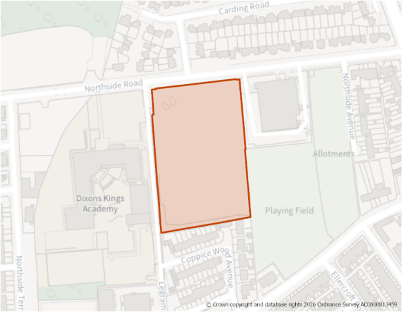
Site Size (ha) Gross: 1.70
Proposed Land Use: Housing
Minimum Development Capacity (Dwellings): 55
Site Type: Greenfield
Ward: Great Horton
Settlement: Bradford South West
Ownership: Private
Delivery Timescale: Short 2025- 2030 (1-5)
Site Specific Requirements:
Design Principles
- Development should provide at least 55 dwellings as part of a high-quality built environment in line with Policies ST4 and DS1, at a net density of 55 dph in line with Policy HO2. This should include affordable housing (in line with Policy HO4) and an appropriate mix of dwellings (in line with Policy HO3 and having due regard to relevant housing needs, evidence and the character of the area).
Site Access, Highways and Transport
- New site access must be delivered from Northside Road, including the incorporation of dropped footway crossings and implementation of adequate visibility splays. Development will need to demonstrate that access and servicing arrangements will not have an adverse impact on the operations of the adjacent Ambulance Station. Early engagement with the Council’s transport and highways team is recommended, to understand and mitigate against transport implications for development of the site.
- The site is situated within 400m of a High Frequency Bus Network via Northside, providing direct links to Bradford City Centre and Halifax. Development will be required to optimise pedestrian connectivity to the network.
Flooding, Water and Drainage
- The site is in Flood Zone 1 though is at is a high risk of groundwater flooding to both surface and subsurface assets. Groundwater may emerge at significant rates and has the capacity to flow overland and/or pond within any topographic low spots. Development will be expected to be served by acceptable drainage infrastructure based on SuDS principles in line with Policy CR4.
Natural and Historic Environment
- The site is an identified Habitat Network, consisting of semi-improved grassland. An Ecology Survey may be required at the planning application stage. Early engagement with the Council’s Biodiversity Officer is recommended.
- The design and layout of any development should ensure due consideration is given to the character of the area.
Environmental Protection
- Development layout must mitigate resident exposure to road emissions and demonstrate that site-generated traffic will not worsen air quality on the nearby NO2 30+ corridor at the junction of Legrams Lane, Ingleby Road and Horton Grance Road.
Open Space and Green / Blue Infrastructure
- Open space should be provided in line with Policy NE2, having regards to the standards set out in Appendix 11. The Open Space Assessment indicates that in Bradford South West there is a need for increased provision of Natural and Semi-natural Greenspace, Outdoor Sports, Parks and Provision for Children.
- The entire site is situated within a Green Infrastructure Corridor, with the south western section of the site located within an area of low provision and high need for green and blue infrastructure. Development proposals should focus on carefully designed green and blue infrastructure to contribute towards site specific issues e.g. flood mitigation, urban cooling, etc.
Infrastructure Requirements
- Proportionate contributions to community infrastructure will be required, where appropriate, in line with Policies ID1 and ID2, and having regard to the Local Infrastructure Plan.
Planning Permission
1. The site benefits from planning permission for 55 dwellings and new access from Northside Road (24/04257/MAF) granted in June 2025. This was after 1 April 2025 (the base date for the Local Plan). Accordingly, it has been identified as a site allocation. Development of this site should take place in line with the approved planning permission.
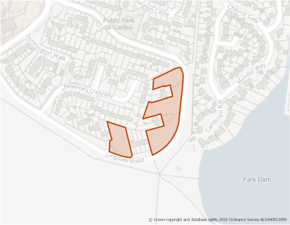
Site Size (ha) Gross: 0.61
Proposed Land Use: Housing
Minimum Development Capacity (Dwellings): 19
Site Type: Greenfield
Ward: Royds
Settlement: Bradford South West
Ownership: Public
Delivery Timescale: Long 2035+ (11+)
Site Specific Requirements:
Design Principles
- The site is open greenfield land which adjoins the residential housing estate of Woodside.
- Development should provide at least 19 dwellings as part of a high-quality built environment in line with Policies ST4 and DS1, at a net density of 35 dph in line with Policy HO2. This should include affordable housing and an appropriate mix of dwellings (in line with Policy HO4) and an appropriate mix of dwellings (in line with Policy HO3 and having due regard relevant housing needs evidence and the character of the area).
Site Access, Highways and Transport
- New site access will likely be required from Lingdale Road, and will need to include the incorporation of dropped footway crossings and implementation of adequate visibility splays. Early engagement with the Council’s transport and highways team is recommended, to understand and mitigate against transport implications for development of the site.
- The site is situated within 400m of a High Frequency Bus Network, providing direct links to Bradford City Centre and Halifax. Development will be required to optimise pedestrian connectivity to the network.
- Access and construction arrangements should give due consideration to a TPO tree located in the rear garden of no. 22 Delf Hill Close immediately north of the site.
Flooding, Water and Drainage
- The site is in Flood Zone 1. Development will be expected to be served by acceptable drainage infrastructure based on SuDS principles in line with Policy CR4.
Natural and Historic Environment
- The site is within a Bat Alert Area. An Ecology Survey may be required at the planning application stage. Early engagement with the Council’s Biodiversity Officer is recommended.
- The design and layout of any development should ensure due consideration is given to the character of the area.
Environmental Protection
- The site is partially within a Development High Risk Area for coal mining, indicating that it contains one or more recorded former related features at surface or shallow depth. A Coal Mining Risk Assessment (CMRA) will be required as part of any planning application.
Open Space and Green / Blue Infrastructure
- Open space should be provided in line with Policy NE2, having regards to the standards set out in Appendix 11. The Open Space Assessment indicates that in Bradford South West there is a need for increased provision of Natural and Semi-natural Greenspace, Outdoor Sports, Parks and Provision for Children.
- The site located within an area of low provision and high need for green and blue infrastructure. Development proposals should focus on carefully designed green and blue infrastructure to contribute towards site specific issues e.g. flood mitigation, urban cooling, etc.
Infrastructure Requirements
- Proportionate contributions to community infrastructure will be required, where appropriate, in line with Policies ID1 and ID2, and having regard to the Local Infrastructure Plan.
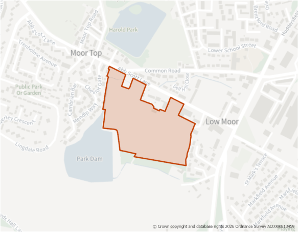
Site Size (ha) Gross: 6.79
Proposed Land Use: Housing
Minimum Development Capacity (Dwellings): 173
Site Type: Greenfield
Ward: Royds
Settlement: Bradford South West
Ownership: Private
Delivery Timescale: Short 2025- 2030 (1-5)
Site Specific Requirements:
Design Principles
- The site is open greenfield land in an edge-of-settlement location.
- Development should provide at least 173 dwellings as part of a high-quality built environment in line with Policies ST4 and DS1, at a net density of 173 dph in line with Policy HO2. This should include affordable housing (in line with Policy HO4) and an appropriate mix of dwellings (in line with Policy HO3 and having due regard to relevant housing needs, evidence and the character of the area).
Site Access, Highways and Transport
- New site access will likely be required from Abb Scott Lane and will need to include the incorporation of dropped footway crossings and implementation of adequate visibility splays. Early engagement with the Council’s transport and highways team is recommended, to understand and mitigate against transport implications for development of the site.
- The site is situated within 400m of a High Frequency Bus Network, providing direct links to Bradford City Centre and Halifax. Development will be required to optimise pedestrian connectivity to the network.
- Access and construction arrangements should give due consideration to the protection of a TPO tree located in the rear garden of no. 22 Delf Hill Close immediately north of the site.
Flooding, Water and Drainage
- The site is in Flood Zone 1 and has negligible risk of groundwater flooding. Development will be expected to be served by acceptable drainage infrastructure based on SuDS principles in line with Policy CR4.
Natural and Historic Environment
- The site consists of a mix of improved grassland and acid, calcareous and neutral grassland, and is located in a Bat Alert Area. An Ecology Survey may be required at the planning application stage. Early engagement with the Council’s Biodiversity Officer is recommended.
- The site is within the setting of several Grade II Listed Buildings directly adjoining the site the north, fronting the southside of Abb Scott Lane. The design of any development proposal will need to respect the character and setting of designated heritage assets, having regard to the character of the surrounding area.
Environmental Protection
- The site is partially within a Development High Risk Area for coal mining, indicating that it contains one or more recorded former related features at surface or shallow depth. A Coal Mining Risk Assessment (CMRA) will be required as part of any planning application.
- Development layout must mitigate resident exposure to road emissions and demonstrate that site-generated traffic will not worsen air quality along the nearby NO2 30+ corridor on Woodside Road/Huddersfield Road.
Open Space and Green / Blue Infrastructure
- Open space should be provided in line with Policy NE2, having regards to the standards set out in Appendix 11. The Open Space Assessment indicates that in Bradford South West there is a need for increased provision of Natural and Semi-natural Greenspace, Outdoor Sports, Parks and Provision for Children.
- The site is in a Green Infrastructure Corridor. The site layout of any future development must demonstrate how it protects the nearby Green Infrastructure Network from adverse impacts, maintains ecological connectivity, and fulfils statutory BNG obligations through targeted habitat preservation, and where possible, enhancement.
- The site is identified as being within an area of low provision and low need for green and blue infrastructure. However, development in this location may increase the need going forward, therefore development proposals should focus on creation of new green and blue infrastructure, including enhancements and connectivity to the existing Green Infrastructure Corridor.
Landscape
- The site is located within the Royds Hall Urban Edge Fringe Valley Urban Edge Wooded Valley and Slopes Character Area/Type (H3). The Council’s Landscape Sensitivity Assessment has identified the site as having a low sensitivity to change.
- Tree planting on the boundaries and throughout the site is encouraged in order to positively integrate development providing visual and ecological connection to existing tree cover. Development should protect the setting of Grade II Listed Moorside Farm through site design and planting. Development should consider the maintenance and enhancement of existing dry-stone walls and historic field boundaries wherever possible.
- A detailed landscape assessment will be required to demonstrate how the development aligns with guidance set out in the Council’s Landscape Character Assessment SPD.
Infrastructure Requirements
- Proportionate contributions to community infrastructure will be required, where appropriate, in line with Policies ID1 and ID2, and having regard to the Local Infrastructure Plan.
Planning Permission
1. The site benefits from planning permission for demolition of 3 agricultural barns and construction of 173 new dwellings, including details of access and associated landscaping (24/02887/MAF) granted in December 2025. This was after 1 April 2025 (the base date for the Local Plan). Accordingly, it has been identified as a site allocation. Development of this site should take place in line with the approved planning permission.
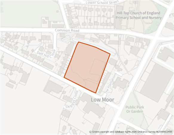
Site Size (ha) Gross: 1.00
Proposed Land Use: Housing
Minimum Development Capacity (Dwellings): 46
Site Type: Greenfield
Ward: Royds
Settlement: Bradford South West
Ownership: Private
Delivery Timescale: Short 2025- 2030 (1-5)
Site Specific Requirements:
Design Principles
- The site is a greenfield infill plot located in an urban residential area.
- Development should provide at least 46 dwellings as part of a high-quality built environment in line with Policies ST4 and DS1, at a net density of 46 dph in line with Policy HO2. This should include affordable housing and an appropriate mix of dwellings (in line with Policy HO4) and an appropriate mix of dwellings (in line with Policy HO3 and having due regard to relevant housing needs evidence and the character of the area).
- A sensitive design and layout will be required taking into consideration the setting of nearby listed buildings and protected trees on-site and nearby.
Site Access, Highways and Transport
- New site access be required from Abb Scott Lane, and will need to include the incorporation of dropped footway crossings and implementation of adequate visibility splays. Early engagement with the Council’s transport and highways team is recommended, to understand and mitigate against transport implications for development of the site.
- The site is situated within 400m of a High Frequency Bus Network, providing direct links to Bradford City Centre and Halifax. Development will be required to optimise pedestrian connectivity to the network.
Flooding, Water and Drainage
- The site is in Flood Zone 1 and has negligible risk of groundwater flooding. Development will be expected to be served by acceptable drainage infrastructure based on SuDS principles in line with Policy CR4.
Natural and Historic Environment
- The site consists of a mix of fen/march/swamp and acid/calcareous/neutral grasslands. It is partially located in a Bat Alert Area. Applications for development should demonstrate consideration of bat foraging routes and explore links the Green Infrastructure Network, An Ecology Survey may be required at the planning application stage. Early engagement with the Council’s Biodiversity Officer is recommended.
- There are two clusters of trees along the southern border designated as TPO Woodland and the eastern boundary of the site is within the 15m buffer zone of two protected trees in adjoining residential rear gardens. The design and layout of any development should ensure these trees are preserved and enhanced in line with Policy NE6. An arboricultural survey should be provided as part of any planning application.
- The site is identified in the LNRS with the preferred measure B3_M02: The enhancement (rather than replacement) of existing habitats on some areas of brownfield so they become high-quality, diverse, wildlife-rich spaces or urban parks (taking site allocations into account). This will help species that rely on brownfield habitats, such as the dingy skipper. Layout and design should allow for significant areas to develop naturally; depending on how permeable the site is, this will also help to control water during excess rainfall.
- The site is within the setting of several Grade II Listed Buildings immediately south, fronting the southside of Abb Scott Lane. The design of any development proposal will need to respect the character and setting of designated heritage assets, having regard to the character of the surrounding area.
Environmental Protection
- The site is in a Development High Risk Area for coal mining, indicating that it contains one or more recorded former related features at surface or shallow depth. A Coal Mining Risk Assessment (CMRA) will be required as part of any planning application.
- Development layout must mitigate resident exposure to road emissions and demonstrate that site-generated traffic will not worsen air quality along the nearby NO2 30+ corridor on Woodside Road/Huddersfield Road.
Open Space and Green / Blue Infrastructure
- Open space should be provided in line with Policy NE2, having regards to the standards set out in Appendix 11. The Open Space Assessment indicates that in Bradford South West there is a need for increased provision of Natural and Semi-natural Greenspace, Outdoor Sports, Parks and Provision for Children.
- The site is located in a Green Infrastructure Corridor. The site is identified as being within an area of low provision and low need for green and blue infrastructure. However, development in this location may increase the need going forward, therefore development proposals should focus on creation of new green and blue infrastructure, including enhancements and connectivity to the existing Green Infrastructure Corridor.
- The site is identified as being within an area of low provision and low need for green and blue infrastructure. However, development in this location may increase the need going forward, therefore development proposals should focus on creation of new green and blue infrastructure, including enhancements and connectivity to the existing Green Infrastructure Corridor.
Landscape
- No landscape sensitivity assessment was undertaken for this site. Consideration should be given to the guidance set out in the Landscape Character Assessment SPD, having regard for protected trees on-site.
Infrastructure Requirements
- Proportionate contributions to community infrastructure will be required, where appropriate, in line with Policies ID1 and ID2, and having regard to the Local Infrastructure Plan.
Planning Permission
- A detailed planning application is currently pending for this site for 42 homes (32 dwellings and 10 apartments) which may be determined before the Local Plan is adopted.
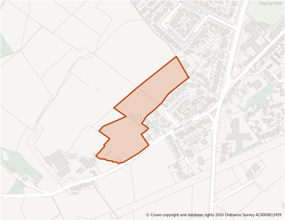
Site Size (ha) Gross: 2.14
Proposed Land Use: Housing
Minimum Development Capacity (Dwellings): 56
Site Type: Greenfield
Ward: Clayton & Fairweather Green
Settlement: Bradford South West
Ownership: Private
Delivery Timescale: Long 2035+ (11+)
Site Specific Requirements:
Design Principles
- The site is a greenfield land in an edge-of-settlement location.
- Development should provide at least 56 dwellings as part of a high-quality built environment in line with Policies ST4 and DS1, at a net density of 35 dph in line with Policy HO2. This should include affordable housing (in line with Policy HO4) and an appropriate mix of dwellings (in line with Policy HO3 and having due regard to relevant housing needs, evidence and the character of the area).
Site Access, Highways and Transport
- New site access be required from Brook Lane, and will need to include the incorporation of dropped footway crossings and implementation of adequate visibility splays. Early engagement with the Council’s transport and highways team is recommended, to understand and mitigate against transport implications for development of the site.
- The site is situated within 400m of a High Frequency Bus Network, providing direct links to Bradford City Centre and Halifax. Development will be required to optimise pedestrian connectivity to the network.
Flooding, Water and Drainage
- The site is in Flood Zone 1 and has a medium risk of groundwater flooding to both surface and subsurface assets, where is the possibility of groundwater emerging at the surface locally. Development will be expected to be served by acceptable drainage infrastructure based on SuDS principles in line with Policy CR4.
Natural and Historic Environment
- Ecology reports identify that the site predominantly consists of acid, calcareous and neutral grassland, as identified on the Living England Habitat Map. An ecology survey may be required at the planning application stage, and early engagement with the Council’s biodiversity officer is recommended.
- There are a number of Listed Buildings located to the east of the site, which is located approx. from the nearest 50m buffer.
- The design of any development proposal will need to respect the character and setting of nearby designated heritage assets, having regard for the semi-rural nature of the application site and character of the surrounding area.
Environmental Protection
- The site partly contains a former landfill site. A Land Contamination Assessment – Phase 1 Report will be required as part of any planning application due determining any potential impacts. Impacts should be addressed in line with Policy CR2.
- The site is in a Development High Risk Area for coal mining, indicating that it contains one or more recorded former related features at surface or shallow depth. A Coal Mining Risk Assessment (CMRA) will be required as part of any planning application.
Open Space and Green / Blue Infrastructure
- Open space should be provided in line with Policy NE2, having regards to the standards set out in Appendix 11. The Open Space Assessment indicates that in Bradford South West there is a need for increased provision of Natural and Semi-natural Greenspace, Outdoor Sports, Parks and Provision for Children.
- The is within a Green Infrastructure Network. The site is identified as being within an area of low provision and low need for green and blue infrastructure. However, development in this location may increase the need going forward, therefore development proposals should focus on creation of new green and blue infrastructure, including enhancements and connectivity to the existing Green Infrastructure Corridor.
Landscape
- The site is located within the Thornton, Queensbury and Wilsden Mixed Upland Character Area/Type (H3). The Council’s Landscape Sensitivity Assessment has identified the site as having a medium overall sensitivity to change, though this reflects the site’s contracting sensitivity. Much of the interior of the site is of lower sensitivity, though the exposed north-western boundary is highly sensitive owing to its elevation, exposure and visibility.
- Development should be pulled back from the north-western edge and restricted to the lower, well-screened parts of the site to avoid significant visual impacts.
- A detailed Landscape Assessment will be required to demonstrate how the development aligns with guidance set out in the Council’s Landscape Character Assessment SPD.
Infrastructure Requirements
- Proportionate contributions to community infrastructure will be required, where appropriate, in line with Policies ID1 and ID2, and having regard to the Local Infrastructure Plan.
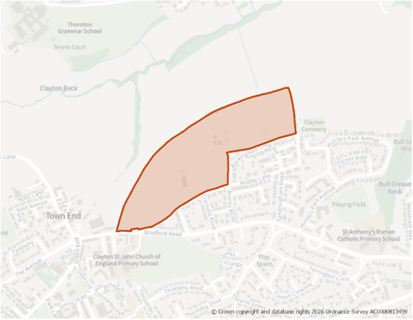
Site Size (ha) Gross: 11.81
Proposed Land Use: Housing
Minimum Development Capacity (Dwellings): 310
Site Type: Greenfield
Ward: Clayton & Fairweather Green
Settlement: Bradford South West
Ownership: Mixed
Delivery Timescale: Long 2035+ (11+)
Site Specific Requirements:
Design Principles
- The site is open greenfield land in an edge-of-settlement location, which has been released from the Green Belt.
- Development should provide at least 310 dwellings as part of a high-quality built environment in line with Policies ST4 and DS1, at a net density of 35 dph in line with Policy HO2. This should include affordable housing (in line with Policy HO4) and an appropriate mix of dwellings (in line with Policy HO3 and having due regard to relevant housing needs, evidence and the character of the area).
- The design and layout of any future development should respond positively to the green infrastructure within the site and the adjacent SPA/SAC, on-site flood risk constraints, and local heritage impacts.
- Enhancements to the surrounding Green Belt land should be made, including improving connections to offer opportunities for residents to access the countryside.
Site Access, Highways and Transport
- Development of the site would constitute a significant urban extension with principal road frontage along Bradford Road to the south, and a network of established residential estate roads to the east and southeast.
- A comprehensive Transport Assessment will be required to support development proposals. The scale of the site will likely require a multi-point access strategy to safety distribute vehicular trip generating, with a new primary access from Bradford Road.
- Development must include the incorporation of dropped footway crossings, implementation of adequate visibility splays, and consideration of road and footway widening, where appropriate.
- The site is located within 400m of High Frequency Bus Network service bus stops providing direct access to Bradford City Centre and Halifax. Development will be required to optimise pedestrian connectivity to the network and incorporate high-quality, safe and direct travel pathways to the site.
Flooding, Water and Drainage
- The site is in Flood Zone 1 though there is a high risk of groundwater flooding to both surface and subsurface assets. Groundwater may emerge at significant rates and has the capacity to flow overland and/or pond within any topographic low spots. Development will be expected to be served by acceptable drainage infrastructure based on SuDS principles in line with Policy CR4.
Natural and Historic Environment
- The site lies within Zone C (Recreational Pressure) of the South Pennine Moors SPA/SAC - Residential development resulting in a net increase in dwellings will be required to mitigate any recreational pressure on the SPA/SAC caused by such development in accordance with the South Pennine Moors SPD and Policy NE3. The site is in Zone C of the South Pennine Moors SPA/SAC 7km recreational pressure impact zone.
- Ecology reports identify that the site predominantly consists of acid/calcareous/neutral grassland, improved grassland and fen/marsh swamp, as identified on the Living England Habitat Map. The site is also partially within a Bat Alert Area. An ecology survey may be required at the planning application stage, and early engagement with the Council’s biodiversity officer is recommended.
- There are a high number of Listed Buildings to the south and south-west of the site, some of which have settings within the site, including Grade II Listed 176-182 Bradford Road which directly adjoin the site’s boundary. Clayton Conservation Area lies to the immediate west/south-west.
- A Heritage Impact Assessment has been undertaken which advises that development of the site would result in harm to the setting of the Listed Buildings and Conservation Area. Mitigation measures, such as setting back the layout of the built form and use of high-quality design and materials, should be incorporated to ensure that harm from development is less than substantial of an acceptable level. The design of any development proposal will need to respect the character and setting of designated heritage assets, having regard for the semi-rural nature of the application site.
- A comprehensive Heritage Impact Assessment will be required to support any future planning application. Early engagement with the Council’s urban design and conservation officer is encouraged.
Environmental Protection
- The site is within/partially within a Development High Risk Area for coal mining, indicating that it contains one or more recorded former related features at surface or shallow depth. A Coal Mining Risk Assessment (CMRA) will be required as part of any planning application.
- The site partly contains a former landfill site. A Land Contamination Assessment – Phase 1 Report will be required as part of any planning application due determining any potential impacts. Impacts should be addressed in line with Policy CR2.
Open Space and Green / Blue Infrastructure
- Open space should be provided in line with Policy NE2, having regards to the standards set out in Appendix 11. The Open Space Assessment indicates that in Bradford South West there is a need for increased provision of Natural and Semi-natural Greenspace, Outdoor Sports, Parks and Provision for Children.
- Open space must be provided in line with Policy NE2, having regard to the standards set out Appendix 11, and satisfying the ‘Golden Rules’ criteria of the NPPF, having due regard to the requirement for new or enhanced publicly-accessible green space. The design and layout of any development should ensure due consideration is given to the site’s Green Infrastructure connectivity and enhancement.
- The site is in a Green Infrastructure Corridor. The site is identified as being within an area of medium provision and low need for green and blue infrastructure. However, development in this location may increase the need going forward, therefore development proposals should focus on creation of new green and blue infrastructure, including enhancements and connectivity to the existing Green Infrastructure Corridor.
Landscape
- The site is located within the Clayton Urban Edge Wooded Valleys and Slopes Landscape Character Area/Type (H2). The Council’s Landscape Sensitivity Assessment identifies the site as having an overall medium sensitivity to change.
- The eastern half of the site where the historic field pattern has been lost to previous land use is less sensitive to change. However, development should be carefully designed to minimise adverse impacts on the Clayton Conservation Area and associated Listed Buildings through the application of layout setbacks and landscape screening from the western/south-western boundary where sensitivity is high.
- A detailed landscape assessment will be required to demonstrate how the development aligns with guidance set out in the Council’s Landscape Character Assessment SPD.
Other Constraints
- The site is split between multiple landowners. Any planning application must be supported by an overarching masterplan that covers the entire allocated site footprint. Individual proposals for separate parcels will be resisted if they result in an uncoordinated layout, create piecemeal development, or restrict future road access to the remaining parts of the allocation.
Green Belt (and Golden Rules)
- This site has been removed from the Green Belt. Development on the site should be consistent with the “Golden Rules” set out in the NPPF in relation to affordable housing, necessary improvements to infrastructure and accessible green space provision.
Infrastructure Requirements
- Proportionate contributions to community infrastructure will be required, where appropriate, in line with Policies ID1 and ID2, and having regard to the Local Infrastructure Plan.
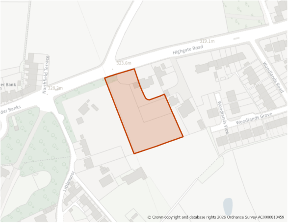
Site Size (ha) Gross: 0.40
Proposed Land Use: Housing
Minimum Development Capacity (Dwellings): 5
Site Type: Greenfield
Ward: Queensbury
Settlement: Bradford South West
Ownership: Private
Delivery Timescale: Short 2025- 2030 (1-5)
Site Specific Requirements:
Design Principles
- The site is greenfield comprising of garden land to rear of detached property.
- Development should provide at least 5 dwellings as part of a high-quality built environment in line with Policies ST4 and DS1, at a net density of 5 dph in line with Policy HO2. This should include affordable housing (in line with Policy HO4) and an appropriate mix of dwellings (in line with Policy HO3 and having due regard to relevant housing needs, evidence and the character of the area).
Site Access, Highways and Transport
- New site access be required from Woodlands and will need to include the incorporation of dropped footway crossings and implementation of adequate visibility splays. Early engagement with the Council’s transport and highways team is recommended, to understand and mitigate against transport implications for development of the site.
- The site is situated within 400m of a High Frequency Bus Network, providing direct links to Bradford City Centre and Halifax. Development will be required to optimise pedestrian connectivity to the network.
Flooding, Water and Drainage
- The site is in Flood Zone 1. There is a risk of flooding to subsurface assets but surface manifestation of groundwater is unlikely. Development will be expected to be served by acceptable drainage infrastructure based on SuDS principles in line with Policy CR4.
Natural and Historic Environment
- The site is within a bat alert area. An ecology survey may be required at the planning application stage. Early engagement with the Council's Biodiversity Officer is recommended.
- The design of any development proposal will need to have regard to the character of the surrounding area.
Open Space and Green / Blue Infrastructure
- Open space should be provided in line with Policy NE2, having regards to the standards set out in Appendix 11. The Open Space Assessment indicates that in Bradford South West there is a need for increased provision of Natural and Semi-natural Greenspace, Outdoor Sports, Parks and Provision for Children.
- The site is within an area of medium provision and medium need for green and blue infrastructure. Development proposals should focus on carefully designed green and blue infrastructure to contribute towards site specific issues e.g. flood mitigation, urban cooling, etc.
Landscape
- Any development should give due consideration to the guidance set out in the Council’s Landscape Character Assessment SPD.
Other Constraints
- The site is adjacent to a high voltage electricity transmission line to the west and is fully within thebuffer zone for overhead or underground high voltage electricity transmission lines/cables.
- Development should include a strategy for responding to the National Grid Overhead Cable Route present within the site which demonstrates how the National Grid Design Guide and Principles have been as part of the design and layout and how the impact of the assets has been reduced through good design.
Infrastructure Requirements
- Proportionate contributions to community infrastructure will be required, where appropriate, in line with Policies ID1 and ID2, and having regard to the Local Infrastructure Plan.
Planning Permission
- The site benefits from outline planning permission for residential development of land for 5 detached dwellings requesting consideration of access (24/04864/OUT) granted May 2025. This was after 1 April 2025 (the base date for the Local Plan). Accordingly, it has been identified as a site allocation. Development of the site should take place in accordance with the outline planning permission and any subsequent reserved matters approval.
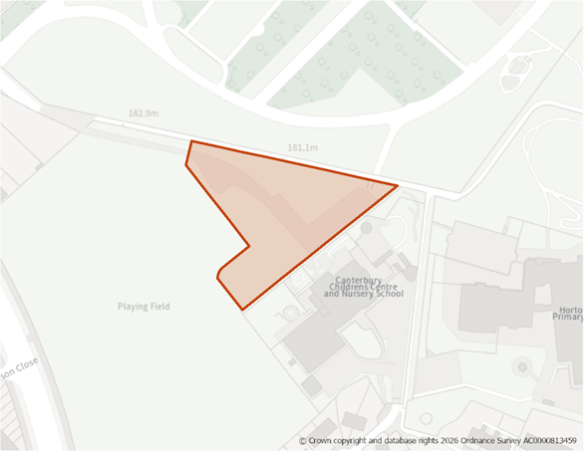
Site Size (ha) Gross: 0.45
Proposed Land Use: Housing
Minimum Development Capacity (Dwellings): 14
Site Type: PDL
Ward: Little Horton
Settlement: Bradford South West
Ownership: Private
Delivery Timescale: Short 2025- 2030 (1-5)
Site Specific Requirements:
Design Principles
- Development should provide at least 14 dwellings as part of a high-quality built environment in line with Policies ST4 and DS1, at a net density of 14 dph in line with Policy HO2. This should include affordable housing (in line with Policy HO4) and an appropriate mix of dwellings (in line with Policy HO3 and having due regard to relevant housing needs, evidence and the character of the area).
Site Access, Highways and Transport
- The site does not have direct frontage onto an existing public highway. It is enclosed by a public footpath to the north and the Canterbury Children's Centre and Nursery to the south. A comprehensive Transport Assessment (TA) and a third-party land access options appraisal will be required.
- Early engagement with the Council’s transport and highways team and the children’s centre is recommended, to understand and mitigate against transport implications for development of the site.
- The site is situated within 400m of a High Frequency Bus Network, providing direct links to Bradford City Centre and Halifax. Development will be required to optimise pedestrian connectivity to the network.
Flooding, Water and Drainage
- The site is in Flood Zone 1. Part oof the site is at medium risk of groundwater flooding to both surface and subsurface assets, with the possibility of groundwater emerging at the surface locally. Development will be expected to be served by acceptable drainage infrastructure based on SuDS principles in line with Policy CR4.
Natural and Historic Environment
- The site consists of a mix of broadleaves/mixed/yew woodland and fen/marsh/swamp, as identified on the Living England Habitat Map, and is located in a Bat Alert Area. An ecology survey may be required at the planning application stage. Early engagement with the Council's Biodiversity Officer is recommended.
- The site consists of broadleaved/mixed/yew woodland and fen/march/swamp, as identified on the Living England Habitat Map. It is identified in the LNRS with the preferred measure B3_M01. This encourages the temporary nature-rich uses on undeveloped smaller non-phased brownfield sites (of more than 0.25 hectares) or on land being used for larger phased developments (more than five hectares).
- The design of any development proposal will need to have regard to the character of the surrounding area.
- The site is located within a bat alert area. An ecological survey will be required as part of any planning application to establish the extent/impacts as well as to identify appropriate mitigation.
Environmental Protection
- This site is located within the Clean Air Zone and development must be in accordance with the requirements set out in Policy CR1.
Open Space and Green / Blue Infrastructure
- Open space should be provided in line with Policy NE2, having regards to the standards set out in Appendix 11. The Open Space Assessment indicates that in Bradford South West there is a need for increased provision of Natural and Semi-natural Greenspace, Outdoor Sports, Parks and Provision for Children.
- The site is within an area of medium provision and medium need for green and blue infrastructure. Development proposals should focus on carefully designed green and blue infrastructure to contribute towards site specific issues e.g. flood mitigation, urban cooling, etc.
- The site is within a Green Infrastructure Corridor and lies within the Bradford City Centre Opportunity Area, as identified in the Green and Blue Infrastructure Strategy (GBIS). The strategy should be consulted to identify opportunities for incorporating measures within the development that enhance the quality of, and connectivity to, the green and blue infrastructure network in this area.
Landscape
- Any development should give due consideration to the guidance set out in the Council’s Landscape Character Assessment SPD.
Infrastructure Requirements
- Proportionate contributions to community infrastructure will be required, where appropriate, in line with Policies ID1 and ID2, and having regard to the Local Infrastructure Plan.
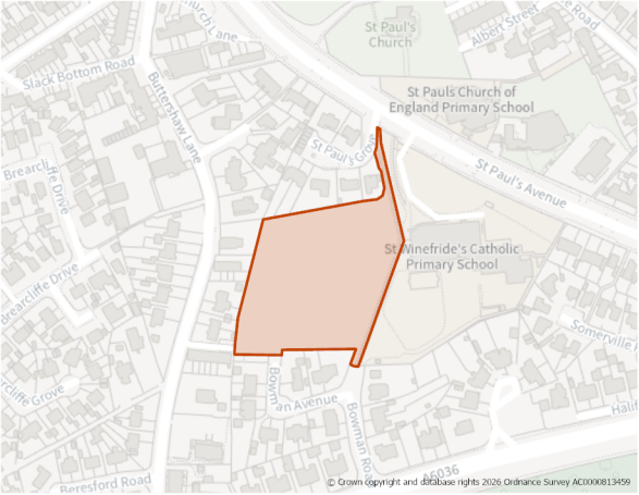
Site Size (ha) Gross: 1.10
Proposed Land Use: Housing
Minimum Development Capacity (Dwellings): 30
Site Type: Greenfield
Ward: Wibsey & Odsal
Settlement: Bradford South West
Ownership: Public
Delivery Timescale: Medium 2030-2035 (6-10)
Site Specific Requirements:
Design Principles
- The site is open greenfield land within the built up urban area.
- This site is allocated for residential development. Development should provide 30 dwellings and should form part of a high-quality built environment in line with Policies ST4 and DS1, at a net density of 50 dph in line with Policy HO2. This should include affordable housing (in line with Policy HO4) and an appropriate mix of dwellings (in line with Policy HO3 and having due regard to relevant housing needs evidence and the character of the area).
Site Access, Highways and Transport
- The site can be accessed from Bowman Road. Early engagement with the Council’s transport and highways team is recommended, to understand and mitigate against transport implications for development of the site.
- The site is situated within 400m of a High Frequency Bus Network, providing direct links to Bradford City Centre and Halifax. Development will be required to optimise pedestrian connectivity to the network.
Flooding, Water and Drainage
- The site is in Flood Zone 1 and has negligible risk of groundwater flooding. Development will be expected to be served by acceptable drainage infrastructure based on SuDS principles in line with Policy CR4.
Natural and Historic Environment
- The site is identified in the LNRS with the preferred measure B2_M02: This encourages the expansion and enhancement of existing mapped priority habitats or the creation of new wetlands on suitable anchor institution land (such as St Winefride's Catholic Primary School directly adjacent) so that sites can use their grounds as connectors to contribute to more joined-up and improved green and blue infrastructure and spaces for nature.
- The site is rough grassland with hedgerows boundaries. Ecology reports identify that the site predominantly consists of acid/calcareous/neutral grassland, as identified on the Living England Habitat Map. Development should provide a strip of species rich wet grassland to the east of any development which will provide educational and wildlife benefits linked to the school on adjacent land. There should also be locally native tree planting, ideally a hedgerow with standard trees adjacent to the houses on the east and south side of the development. An ecology survey may be required at the planning application stage. Early engagement with the Council's Biodiversity Officer is recommended.
- The design of any development proposal will need to have regard to the character of the surrounding area.
Environmental Protection
- The site is within a Development Low Risk Area for coal mining with a section of the site to the southwest sitting within a Development High Risk Area, indicating that it contains one or more recorded former related features at surface or shallow depth. A Coal Mining Risk Assessment (CMRA) will be required as part of any planning application.
- The site is within the 150m (to the east) and 250m to the (west) buffer of a former landfill site. A Land Contamination Assessment – Phase 1 Report will be required as part of any planning application.
Open Space and Green / Blue Infrastructure
- Open space should be provided in line with Policy NE2, having regards to the standards set out in Appendix 11. The Open Space Assessment indicates that in Bradford South West there is a need for increased provision of Natural and Semi-natural Greenspace, Outdoor Sports, Parks and Provision for Children.
- The site is located in a Green Infrastructure Corridor. It is also within an area of medium provision and low need for green and blue infrastructure. Development proposals should focus on carefully designed green and blue infrastructure to contribute towards site specific issues e.g. flood mitigation, urban cooling, etc., which links to the existing networks.
Landscape
- Any development should give due consideration to the guidance set out in the Council’s Landscape Character Assessment SPD.
Other Constraints
- The site is within a Mineral Safeguarding Area (MSA) for coal. A mineral resource assessment will be required as part of any planning application to determine the extent and availability of any coal resource.
Infrastructure Requirements
- Proportionate contributions to community infrastructure will be required, where appropriate, in line with Policies ID1 and ID2, and having regard to the Local Infrastructure Plan.
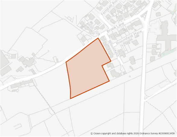
Site Size (ha) Gross: 1.12
Proposed Land Use: Housing
Minimum Development Capacity (Dwellings): 35
Site Type: Greenfield
Ward: Clayton & Fairweather Green
Settlement: Bradford South West
Ownership: Private
Delivery Timescale: Long 2035+ (11+)
Site Specific Requirements:
Design Principles
- The site is open greenfield land in an edge-of-settlement location.
- This site is allocated for residential development. Development should provide 35 dwellings and should form part of a high-quality built environment in line with Policies ST4 and DS1, at a net density of 35 dph in line with Policy HO2. This should include affordable housing (in line with Policy HO4) and an appropriate mix of dwellings (in line with Policy HO3 and having due regard to relevant housing needs evidence and the character of the area).
Site Access, Highways and Transport
- New site access be required from Brook Lane and will need to include the incorporation of dropped footway crossings and implementation of adequate visibility splays. Early engagement with the Council’s transport and highways team is recommended, to understand and mitigate against transport implications for development of the site.
- The site is situated within 400m of a High Frequency Bus Network, providing direct links to Bradford City Centre and Halifax. Development will be required to optimise pedestrian connectivity to the network.
Flooding, Water and Drainage
- The site is in Flood Zone 1. Part of the site is at medium risk of groundwater flooding to both surface and subsurface assets, with the possibility of groundwater emerging at the surface locally. Development will be expected to be served by acceptable drainage infrastructure based on SuDS principles in line with Policy CR4.
Natural and Historic Environment
- Ecology reports identify that the site predominantly consists of acid/calcareous/neutral grassland, as identified on the Living England Habitat Map. An ecology survey may be required at the planning application stage. Early engagement with the Council's Biodiversity Officer is recommended.
- The design of any development proposal will need to have regard to the character of the surrounding area.
Environmental Protection
- The site is within the 250m buffer of a former landfill site. A Land Contamination Assessment – Phase 1 Report will be required as part of any planning application.
Open Space and Green / Blue Infrastructure
- Open space should be provided in line with Policy NE2, having regards to the standards set out in Appendix 11. The Open Space Assessment indicates that in Bradford South West there is a need for increased provision of Natural and Semi-natural Greenspace, Outdoor Sports, Parks and Provision for Children.
- The site within a Green Infrastructure Corridor and is within an area of low provision and low need for green and blue infrastructure. Development proposals should focus on carefully designed green and blue infrastructure to contribute towards site specific issues e.g. flood mitigation, urban cooling, etc., as well as connectivity to existing networks.
- The southern portion of the site lies within a Green Infrastructure Opportunity Corridor, as identified in the Green and Blue Infrastructure Strategy (GBIS), situated between two established Green Infrastructure Corridors. The strategy should be consulted to identify opportunities for incorporating measures within the development that enhance the quality of, and connectivity to, the green and blue infrastructure network in this area.
Landscape
- The site is within the Thornton, Queensbury and Wilsden Mixed Upland Pasture landscape character area/type (E1). The Council’s Landscape Sensitivity Assessment identifies the site as having an overall medium sensitivity to change, though being of contrasting sensitivity across the site. Whilst much of the interior of the site is of lower sensitivity, the exposed north-western boundary is highly sensitive due to its elevation, exposure and visibility. Development should be pulled back from the north-western edge and restricted to the lower, well-screened parts of the site to avoid significant visual impacts.
- A detailed landscape assessment will be required to demonstrate how the development aligns with guidance set out in the Council’s Landscape Character Assessment SPD.
Infrastructure Requirements
- Proportionate contributions to community infrastructure will be required, where appropriate, in line with Policies ID1 and ID2, and having regard to the Local Infrastructure Plan.
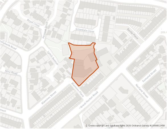
Site Size (ha) Gross: 0.29
Proposed Land Use: Housing
Minimum Development Capacity (Dwellings): 15
Site Type: PDL
Ward: Great Horton
Settlement: Bradford South West
Ownership: Private
Delivery Timescale: Medium 2030-2035 (6-10)
Site Specific Requirements:
Design Principles
- This site is allocated for residential development. Development should provide 35 dwellings and should form part of a high-quality built environment in line with Policies ST4 and DS1, at a net density of 35 dph in line with Policy HO2. This should include affordable housing (in line with Policy HO4) and an appropriate mix of dwellings (in line with Policy HO3 and having due regard to relevant housing needs evidence and the character of the area).
Site Access, Highways and Transport
- New site access be required and will need to include the incorporation of dropped footway crossings and implementation of adequate visibility splays. Early engagement with the Council’s transport and highways team is recommended, to understand and mitigate against transport implications for development of the site.
- The site is situated within 400m of a High Frequency Bus Network, providing direct links to Bradford City Centre and Halifax. Development will be required to optimise pedestrian connectivity to the network.
Flooding, Water and Drainage
- The site is in Flood Zone 1 and has negligible risk of groundwater flooding. Development will be expected to be served by acceptable drainage infrastructure based on SuDS principles in line with Policy CR4.
Natural and Historic Environment
- The majority of the site covered is within a bat alert area. An ecology survey may be required at the planning application stage. Early engagement with the Council's Biodiversity Officer is recommended.
- The site within the setting of Grade II Listed 808 Great Horton Road which is directly adjacent to the site to the north east.
- The design of any development proposal will need to respect the character and setting of the adjacent designated heritage asset, having regard the character of the surrounding area.
Environmental Protection
- Development layout must mitigate resident exposure to road emissions and demonstrate that site-generated traffic will not worsen air quality along the nearby NO2 30+ corridor on Great Horton Road.
Open Space and Green / Blue Infrastructure
- Open space should be provided in line with Policy NE2, having regards to the standards set out in Appendix 11. The Open Space Assessment indicates that in Bradford South West there is a need for increased provision of Natural and Semi-natural Greenspace, Outdoor Sports, Parks and Provision for Children.
- The site is within an area of low provision and high need for green and blue infrastructure. Development proposals should focus on carefully designed green and blue infrastructure to contribute towards site specific issues e.g. flood mitigation, urban cooling, etc.
Landscape
- Any development should give due consideration to the guidance set out in the Council’s Landscape Character Assessment SPD.
Infrastructure Requirements
- Proportionate contributions to community infrastructure will be required, where appropriate, in line with Policies ID1 and ID2, and having regard to the Local Infrastructure Plan.
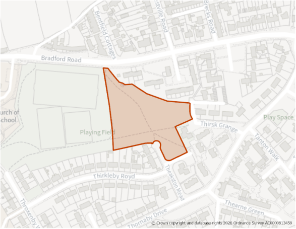
Site Size (ha) Gross: 1.08
Proposed Land Use: Housing
Minimum Development Capacity (Dwellings): 34
Site Type: Greenfield
Ward: Clayton & Fairweather Green
Settlement: Bradford South West
Ownership: Mixed
Delivery Timescale: Long 2035+ (11+)
Site Specific Requirements:
Design Principles
- This site is allocated for residential development. Development should provide 34 dwellings and should form part of a high-quality built environment in line with Policies ST4 and DS1, at a net density of 35 dph in line with Policy HO2. This should include affordable housing (in line with Policy HO4) and an appropriate mix of dwellings (in line with Policy HO3 and having due regard to relevant housing needs evidence and the character of the area).
Site Access, Highways and Transport
- New site access be required and will need to include the incorporation of dropped footway crossings and implementation of adequate visibility splays. Early engagement with the Council’s transport and highways team is recommended, to understand and mitigate against transport implications for development of the site.
- The site is situated within 400m of a High Frequency Bus Network, providing direct links to Bradford City Centre and Halifax. Development will be required to optimise pedestrian connectivity to the network.
Flooding, Water and Drainage
- The site is in Flood Zone 1 though there is a high risk of groundwater flooding to both surface and subsurface assets. Groundwater may emerge at significant rates and has the capacity to flow overland and/or pond within any topographic low spots. Development will be expected to be served by acceptable drainage infrastructure based on SuDS principles in line with Policy CR4.
Natural and Historic Environment
- The site lies within Zone C (Recreational Pressure) - Residential development resulting in a net increase in dwellings will be required to mitigate any recreational pressure on the SPA/SAC caused by such development in accordance with the South Pennine Moors SPD and Policy NE3.
- The site consists of improved grassland, as identified on the Living England Habitat Map. It adjoins to identified Wildlife Habitat Network (Grassland habitat networks) to the south eastern extent of the site boundary. An ecology survey may be required at the planning application stage. Early engagement with the Council's Biodiversity Officer is recommended.
Environmental Protection
- An operational substation is located at the north-western corner of the site. Any future housing layout must position dwellings away from the south-eastern corner to ensure adequate separation distances, to safeguard future residents from any localised noise or visual intrusion.
Open Space and Green / Blue Infrastructure
- Open space should be provided in line with Policy NE2, having regards to the standards set out in Appendix 11. The Open Space Assessment indicates that in Bradford South West there is a need for increased provision of Natural and Semi-natural Greenspace, Outdoor Sports, Parks and Provision for Children.
- The site is within an area of low provision and medium need for green and blue infrastructure. Development proposals should focus on carefully designed green and blue infrastructure to contribute towards site specific issues e.g. flood mitigation, urban cooling, etc.
Infrastructure Requirements
- Proportionate contributions to community infrastructure will be required, where appropriate, in line with Policies ID1 and ID2, and having regard to the Local Infrastructure Plan.
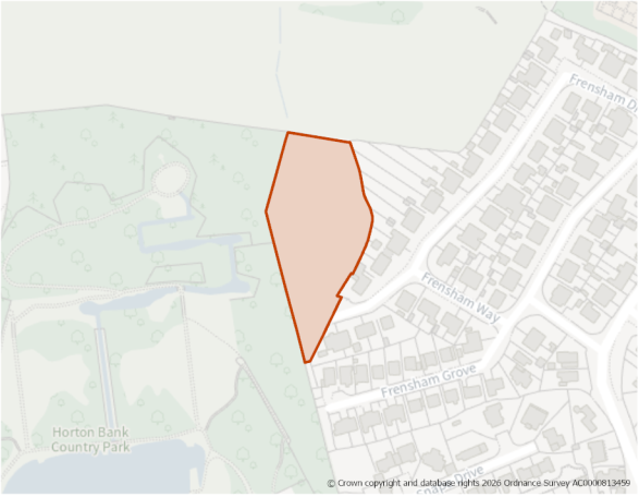
Site Size (ha) Gross: 0.81
Proposed Land Use: Housing
Minimum Development Capacity (Dwellings): 26
Site Type: Greenfield
Ward: Royds
Settlement: Bradford South West
Ownership: Private
Delivery Timescale: Medium 2030-2035 (6-10)
Site Specific Requirements:
Design Principles
- The site is open greenfield land in an edge-of-settlement location, which has been released from the Green Belt.
- Development should provide at least 26 dwellings as part of a high-quality built environment in line with Policies ST4 and DS1, at a net density of 35 dph in line with Policy HO2. This should include affordable housing (in line with Policy HO4) and an appropriate mix of dwellings (in line with Policy HO3 and having due regard to relevant housing needs, evidence and the character of the area).
- Enhancements to the surrounding Green Belt land should be made, including improving connections to offer opportunities for residents to access the countryside.
Site Access, Highways and Transport
- Access to the site is via Frensham Drive. Early engagement with the Council’s transport and highways team is recommended, to understand and mitigate against transport implications for development of the site.
- The site is situated within 400m of a High Frequency Bus Network, providing direct links to Bradford City Centre and Halifax. Development will be required to optimise pedestrian connectivity to the network.
Flooding, Water and Drainage
- The site is in Flood Zone 1. Part of the site is at medium risk of groundwater flooding to both surface and subsurface assets, with the possibility of groundwater emerging at the surface locally. Development will be expected to be served by acceptable drainage infrastructure based on SuDS principles in line with Policy CR4.
Natural and Historic Environment
- The northeastern corner of the site is within a 15m buffer zone of a group of trees located in the adjacent Clayton golf course that are subject to a Woodland TPO which are protected by Tree Preservation Orders. The design and layout of any development should ensure the buffer zone of these trees is preserved and enhanced in line with Policy NE6. An arboricultural survey should be provided as part of any planning application.
- The site consists of broadleaved, mixed and yew woodland, as identified on the Living England Habitat Map, and is adjacent to Horton Bank Country Park Local Wildlife Site to the west.
- The site is within a bat alert area. An ecology survey may be required at the planning application stage. Early engagement with the Council's Biodiversity Officer is recommended.
- The design of any development proposal will need to have regard to the character of the surrounding area.
Environmental Protection
- The site lies within Zone C (Recreational Pressure) of the South Pennine Moors SPA/SAC – Residential development resulting in a net increase in dwellings will be required to mitigate any recreational pressure on the SPA/SAC caused by such development in accordance with the South Pennine Moors SPD and Policy NE3.
- The site is located within a bat alert area. An ecological survey will be required as part of any planning application to establish the extent/impacts as well as to identify appropriate mitigation.
Open Space and Green / Blue Infrastructure
- Open space should be provided in line with Policy NE2, having regards to the standards set out in Appendix 11. The Open Space Assessment indicates that in Bradford South West there is a need for increased provision of Natural and Semi-natural Greenspace, Outdoor Sports, Parks and Provision for Children.
- The site is partially within a Green Infrastructure Corridor and is within an area of medium provision and medium need for green and blue infrastructure. Development proposals should focus on carefully designed green and blue infrastructure to contribute towards site specific issues e.g. flood mitigation, urban cooling, etc., including connectivity to existing networks.
Landscape
- The site is within the Thornton, Queensbury and Wilsden Mixed Upland Pasture landscape character area/type E1. A Landscape Sensitivity Assessment has not been undertaken for this site. Any development should give due consideration to the guidance set out in the Council’s Landscape Character Assessment SPD.
Green Belt (and Golden Rules)
- Site has been removed from the Green Belt. Development on the site should be consistent with the “Golden Rules” set out in the NPPF in relation to affordable housing, necessary improvements to infrastructure and accessible green space provision.
Infrastructure Requirements
- Proportionate contributions to community infrastructure will be required, where appropriate, in line with Policies ID1 and ID2, and having regard to the Local Infrastructure Plan.
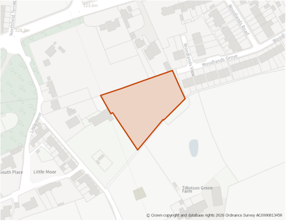
Site Size (ha) Gross: 0.40
Proposed Land Use: Housing
Minimum Development Capacity (Dwellings): 13
Site Type: Greenfield
Ward: Queensbury
Settlement: Bradford South West
Ownership: Private
Delivery Timescale: Long 2035+ (11+)
Site Specific Requirements:
Design Principles
- Development should provide at least 13 dwellings as part of a high quality built environment in line with Policy DS1, at a net density of 35dph in line with Policy HO2. This should include affordable housing (in line with Policy HO4) and an appropriate mix of dwellings (in line with Policy HO3 and having due regard to relevant housing needs, evidence and the character of the area).
Site Access, Highways and Transport
- A new site access from Woodlands Grove will be required and will need to include the incorporation of dropped footway crossings and implementation of adequate visibility splays. Early engagement with the Council’s transport and highways team is recommended, to understand and mitigate against transport implications for development of the site.
- The site is situated within 400m of a High Frequency Bus Network, providing direct links to Bradford City Centre and Halifax. Development will be required to optimise pedestrian connectivity to the network.
Flooding, Water and Drainage
- The site is in Flood Zone 1. Part of the site is at medium risk of groundwater flooding to both surface and subsurface assets, with the possibility of groundwater emerging at the surface locally. Development will be expected to be served by acceptable drainage infrastructure based on SuDS principles in line with Policy CR4.
Natural and Historic Environment
- The site lies within Zone C (Recreational Pressure) – Residential development resulting in a net increase in dwellings will be required to mitigate any recreational pressure on the SPA/SAC caused by such development in accordance with the South Pennine Moors SPD and Policy NE3.
- Ecology reports identify that the site predominantly consists of acid, calcareous and neutral grassland, as identified on the Living England Habitat Map. The site is also within a bat alert area. An ecology survey will be required at the planning application stage. Early engagement with the Council's Biodiversity Officer is recommended.
- The design of any development proposal will need to have regard to the character of the surrounding area.
Environmental Protection
- The site is adjacent to a high voltage electricity transmission line to the west and is fully within thebuffer zone for overhead or underground high voltage electricity transmission lines/cables.
- Development should include a strategy for responding to the National Grid Overhead Cable Route present within the site which demonstrates how the National Grid Design Guide and Principles have been as part of the design and layout and how the impact of the assets has been reduced through good design.
Open Space and Green / Blue Infrastructure
- Open space should be provided in line with Policy NE2, having regards to the standards set out in Appendix 11. The Open Space Assessment indicates that in Bradford South West there is a need for increased provision of Natural and Semi-natural Greenspace, Outdoor Sports, Parks and Provision for Children.
- The site is in a Green Infrastructure Corridor and is within an area of medium provision and medium need for green and blue infrastructure. Development proposals should focus on carefully designed green and blue infrastructure to contribute towards site specific issues e.g. flood mitigation, urban cooling, etc., including connectivity to existing green infrastructure networks.
Infrastructure Requirements
- Proportionate contributions to community infrastructure will be required, where appropriate, in line with Policies ID1 and ID2, and having regard to the Local Infrastructure Plan.
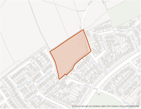
Site Size (ha) Gross: 1.09
Proposed Land Use: Housing
Minimum Development Capacity (Dwellings): 34
Site Type: Greenfield
Ward: Clayton & Fairweather Green
Settlement: Bradford South West
Ownership: Private
Delivery Timescale: Medium 2030-2035 (6-10)
Site Specific Requirements:
Design Principles
- The site is allocated for residential development. Development should provide at least 34 dwellings as part of a high quality built environment in line with Policy DS1, at a net density of 35dph in line with Policy HO2. This should include affordable housing (in line with Policy HO4) and an appropriate mix of dwellings (in line with Policy HO3 and having regard to the relevant housing needs evidence and character of the area).
- A sensitive design and layout will be required taking into consideration the sites location on the edge of the settlement, landscape impact and its sloping topography as well as presence of protected trees.
Site Access, Highways and Transport
- A new access will be required. Early engagement with the Council’s transport and highways team is recommended, to understand and mitigate against transport implications for development of the site.
- The site is situated within 400m of a High Frequency Bus Network, providing direct links to Bradford City Centre and Halifax. Development will be required to optimise pedestrian connectivity to the network.
Flooding, Water and Drainage
- The site is in Flood Zone 1 and at medium risk of groundwater flooding to both surface and subsurface assets, with the possibility of groundwater emerging at the surface locally. Development will be expected to be served by acceptable drainage infrastructure based on SuDS principles in line with Policy CR4.
Natural and Historic Environment
- The site lies within Zone C (Recreational Pressure) of the South Pennine Moors SPA/SAC – Residential development resulting in a net increase in dwellings will be required to mitigate any recreational pressure on the SPA/SAC caused by such development in accordance with the South Pennine Moors SPD and Policy NE3.
- The design of any development proposal will need to have regard to the character of the surrounding area.
Environmental Protection
- The site is partly within the 150m and 2050m buffer of a former landfill site. A Land Contamination Assessment – Phase 1 Report will be required as part of any planning application.
Open Space and Green / Blue Infrastructure
- Open space should be provided in line with Policy NE2, having regards to the standards set out in Appendix 11. The Open Space Assessment indicates that in Bradford South West there is a need for increased provision of Natural and Semi-natural Greenspace, Outdoor Sports, Parks and Provision for Children.
- The site is within an area of low provision and medium need for green and blue infrastructure. Development proposals should focus on carefully designed green and blue infrastructure to contribute towards site specific issues e.g. flood mitigation, urban cooling, etc.
Landscape
- The site is within the Thornton, Queensbury and Wilsden Mixed Upland Pasture landscape character area/type E1. The overwhelming perception of this landscape is one of elevation and exposure. The area has a strong visual connection with the urban area of Bradford. A detailed landscape assessment will be required to demonstrate how the development aligns with guidance set out in the Council’s Landscape Character Assessment SPD.
Green Belt (and Golden Rules)
- The site has been removed from the Green Belt. Development on the site should be consistent with the “Golden Rules” set out in the NPPF in relation to affordable housing, necessary improvements to infrastructure and accessible green space provision.
Infrastructure Requirements
- Proportionate contributions to community infrastructure will be required, where appropriate, in line with Policies ID1 and ID2, and having regard to the Local Infrastructure Plan.
Planning Permission
- An outline planning application (26/00516/MAO) is currently pending on this site for residential development including associated infrastructure works. All matters reserved except means of access into (but not within) the site from Rambling Walk. This application may be determined before the Local Plan is adopted.
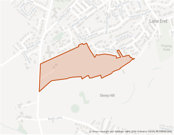
Site Size (ha) Gross: 8.01
Proposed Land Use: Housing
Minimum Development Capacity (Dwellings): 210
Site Type: Greenfield
Ward: Clayton & Fairweather Green
Settlement: Bradford South West
Ownership: Private
Delivery Timescale: Medium 2030-2035 (6-10)
Site Specific Requirements:
Design Principles
- The site is open greenfield land in an edge-of-settlement location, which has been released from the Green Belt.
- The site is allocated for residential development. Development should provide at least 210 dwellings as part of a high quality built environment in line with Policy DS1, at a net density of 35dph. This should include affordable housing (in line with Policy HO4) and an appropriate mix of dwellings (in line with Policy HO3 and having regard to the relevant housing needs evidence and character of the area).
- A sensitive design and layout will be required taking into consideration the sites location on the edge of the settlement, landscape impact and its sloping topography as well as presence of protected trees.
Site Access, Highways and Transport
- Development of the site would constitute a significant urban extension with principal road frontage along Baldwin Lane to the west, and a network of established residential estate roads to the north.
- A comprehensive Transport Assessment will be required to support development proposals. The scale of the site will likely require a multi-point access strategy to safety distribute vehicular trip generating, with a new primary access from Baldwin Lane.
- A spine road should be provided through the site with primary access from Baldwin Lane and secondary access connections at Oakleigh Avenue and Blackberry Way, but the layout should not encourage rat running traffic. Footway will be required across site frontage on Baldwin Lane. Virginia Terrace to the east of the site is substandard in width and geometry and lacks footways and therefore should only be considered as walking and cycling connection.
- Development must include the incorporation of dropped footway crossings, implementation of adequate visibility splays, and consideration of road and footway widening, where appropriate. Early engagement with the Council’s transport and highways team is recommended, to understand and mitigate against transport implications for development of the site.
- The site is located within 400m of High Frequency Bus Network service bus stops providing direct access to Bradford City Centre and Halifax. Development will be required to optimise pedestrian connectivity to the network and incorporate high-quality, safe and direct travel pathways to the site.
Flooding, Water and Drainage
- The site is in Flood Zone 1. Parts of the site are at medium risk of groundwater flooding to both surface and subsurface assets, with the possibility of groundwater emerging at the surface locally. Development will be expected to be served by acceptable drainage infrastructure based on SuDS principles in line with Policy CR4.
Natural and Historic Environment
- Part of the site is identified in the LNRS with the preferred measure G1_M03: Significantly increase the number of trees and woodlands in urban areas for the long term. This recommended the planting and maintenance of resilient species that are good for nature, particularly in areas where there is less or no existing canopy cover. Development should optimise the creation of 'stepping stones' and 'corridors' to link habitats. Where people use an area in different ways, the focus should be on wider edges and margins, as well as copses, to recognise and increase the value (social, cultural, recreational) of open spaces for communities.
- Langberries Farm, a Grade II Listed Building is located within the site to the east. Development must provide a suitable landscaped buffer or area of open space around Langberries Farm to enable views of the farm to be maintained and allow the buildings to be viewed in the context of open space and to allow an understanding of their historic function. This should be substantial enough to provide meaningful and effective separation between the development and the heritage assets and how this then merges into the site be properly considered so that the design and layout of the development integrates the heritage assets and the open space holistically into the overall proposal.
- The site is within close proximity to Upper Penny Hill farmhouse, barn and stables and Lower Penny Hill farmhouse, stable and barn. A similar approach is likely to be required to the wider site allocation in the areas of the site that are in close proximity to Upper Penny Hill farmhouse, barn and stables and Lower Penny Hill farmhouse, stable and barn.
- A significant set back of development of the area in the southeast corner of the wider site, in close proximity to the Jaamiatul Imaam Muhammad Zakaria (former workhouse/hospital) will be required to mitigate the impacts of the loss of openness of the setting and to maintain a sense of distinction and separation of the heritage assets from surrounding development.
- Development of the rest of the site, and in particular the areas close to the heritage assets should respond to and take design cues from the listed buildings, their form and character. This is likely to inform the layout, design and scale of dwellings within the site as well as the materials and landscape strategy.
Environmental Protection
- The site is partly within Development High Risk Area (southern part of the site) remaining part of the site is Wholly within Development Low Risk Area
- The site is partly within the 250m buffer of a former landfill site. Impacts should be addressed in line with Policy CR2.
Open Space and Green / Blue Infrastructure
- Open space should be provided in line with Policy NE2, having regards to the standards set out in Appendix 11 and satisfying the ‘Golden Rules’ criteria of the NPPF, having due regard to the requirement for new or enhanced publicly-accessible green space. The layout must preserve a substantial open green space buffer across the northern edge of the site to maintain strategic connectivity. The Open Space Assessment indicates that in Bradford South West there is a need for increased provision of Natural and Semi-natural Greenspace, Outdoor Sports, Parks and Provision for Children.
- The site is partly within an area of low provision and low need for green and blue infrastructure. However, development in this location may increase the need going forward, therefore development proposals should focus on creation of new green and blue infrastructure.
- The southern portion of the site lies within a Green Infrastructure Opportunity Corridor, as identified in the Green and Blue Infrastructure Strategy (GBIS), situated between two established Green Infrastructure Corridors. The strategy should be consulted to identify opportunities for incorporating measures within the development that enhance the quality of, and connectivity to, the green and blue infrastructure network in this area.
Landscape
- The site is within the Thornton, Queensbury and Wilsden Mixed Upland Pasture landscape character area/type E1. The overwhelming perception of this landscape is one of elevation and exposure. The area has a strong visual connection with the urban area of Bradford. A detailed landscape assessment will be required to demonstrate how the development aligns with guidance set out in the Council’s Landscape Character Assessment SPD.
Green Belt (and Golden Rules)
- Th site has been removed from the Green Belt. Development on the site should be consistent with the “Golden Rules” set out in the NPPF in relation to affordable housing, necessary improvements to infrastructure and accessible green space provision.
Infrastructure Requirements
- Proportionate contributions to community infrastructure will be required, where appropriate, in line with Policies ID1 and ID2, and having regard to the Local Infrastructure Plan.
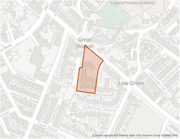
Site Size (ha) Gross: 0.50
Proposed Land Use: Housing
Minimum Development Capacity (Dwellings): 23
Site Type: PDL
Ward: Great Horton
Settlement: Bradford South West
Ownership: Private
Delivery Timescale: Long 2035+ (11+)
Site Specific Requirements:
Design Principles
- The site constitutes previously developed land and contains the Grade II Listed Bell House to the north, a former chapel which is currently derelict and fire damaged, and the Grade II Listed former Great Horton First School which last was used as a residential care home located to the south of the site. The surrounding area is predominantly residential.
- The site is allocated for residential development. A sympathetic conversion of the two buildings and possibly some sensitive redevelopment should be undertaken to deliver a yield of 23 dwellings. Consideration should be given to the use of appropriate materials and landscaping to ensure the sensitive restoration of the heritage assets and their settings is achieved.
Site Access, Highways and Transport
- Site access is available from Southfield Lane and Belton Close where there are footways and street lighting available.
Flooding, Water and Drainage
- The site is within Flood Zone 1. The central part of the site includes a small area which is at low and medium surface water flood risk. Development will need to provide the relevant drainage infrastructure based on SuDS principles in line with Policy CR4 where appropriate.
Natural and Historic Environment
- There are no ecological, biodiversity or geological constraints on the site.
- The site lies within the Great Horton Conservation Area and is occupied by the Grade II Listed Bell House and Grade II Listed former Great Horton First School. The site also lies within a 50m buffer of a cluster of other Listed Buildings.
- A Heritage Impact Assessment (HIA) has been carried out for this site and indicates that its development would result in less than substantial harm of an unacceptable level as there is limited opportunity to effectively mitigate the resulting impact of development on the designated heritage asset. The HIA does however indicate that the conversion of the listed buildings may be possible, subject to an evaluation of heritage significance and the impacts any proposal might have. It suggests that the sympathetic re-use of the listed buildings could achieve an impact of an acceptable level.
- It is considered that the wider public and sustainability benefits provided by the sensitive conversion of the buildings are such that the allocation of the site in the plan is considered a necessary part of the development strategy for the settlement. A more detailed HIA, for the specific proposed scheme will need to be carried out at the planning application stage working closely with the Council’s Heritage team, to develop appropriate mitigation measures to reduce the harm as much as is possible.
Environmental Protection
- Site is within/partially within a Development High Risk Area for coal mining, indicating that it contains one or more recorded former related features at surface or shallow depth. Coal Authority Mapping indicates a possible mine entry shaft along the northern edge of the site. A Coal Mining Risk Assessment (CMRA) will be required as part of any planning application.
- The site contains potential risk of contamination from historical uses. A site investigation should be carried out to explore the extent of potential land contamination on site.
- The site is within a Mineral Safeguarding Area (MSA) for coal. A mineral resource assessment will be required as part of any planning application to determine the extent and availability of any coal resource.
Open Space and Green / Blue Infrastructure
- Open space should be provided in line with Policy NE2, having regards to the standards set out in Appendix 11. The Open Space Assessment indicates that in Bradford South West there is a need for increased provision of Natural and Semi-natural Greenspace, Outdoor Sports, Parks and Provision for Children.
- The site is partly within an area of low provision and high need for green and blue infrastructure. However, development in this location may increase the need going forward, therefore development proposals should focus on creation of new green and blue infrastructure.
Infrastructure Requirements
- Proportionate contributions to community infrastructure will be required, where appropriate, in line with Policies ID1 and ID2, and having regard to the Local Infrastructure Plan.
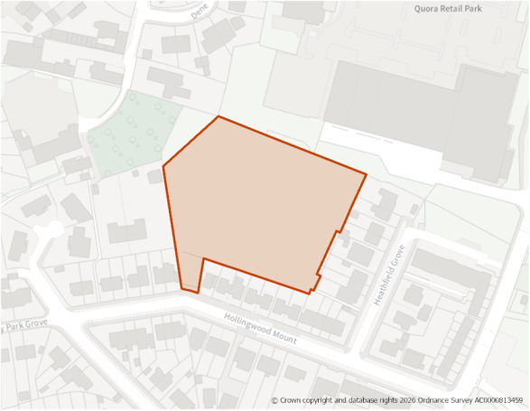
Site Size (ha) Gross: 0.85
Proposed Land Use: Housing
Minimum Development Capacity (Dwellings): 26
Site Type: Greenfield
Ward: Great Horton
Settlement: Bradford South West
Ownership: Private
Delivery Timescale: Short 2025- 2030 (1-5)
Site Specific Requirements:
Design Principles
- The site comprises a former football ground now greenfield land within an urban area predominantly comprising residential and commercial uses.
- The site is allocated for residential development. Development should provide a minimum of 26 dwellings as part of a high-quality built environment in line with Policies ST4 and DS1, at a net density of 35 dph. This should include affordable housing in line with Policy HO5, having due regard to relevant housing needs evidence and the character of the area.
Site Access, Highways and Transport
- A new site access would be required. This would be from Hollingwood Mount where footways and streetlighting are present.
Flooding, Water and Drainage
- The site is within Flood Zone 1 though there is a high risk of groundwater flooding to both surface and subsurface assets. Groundwater may emerge at significant rates and has the capacity to flow overland and/or pond within any topographic low spots. Development will be expected to be served by acceptable drainage infrastructure based on SuDS principles in line with Policy CR4.
Natural and Historic Environment
- The site lies within Zone C (Recreational Pressure) – Residential development resulting in a net increase in dwellings will be required to mitigate any recreational pressure on the SPA/SAC caused by such development in accordance with the South Pennine Moors SPD and Policy NE3.
- The site is identified in the LNRS with the preferred measure B2_M04: Significantly boost the quality of existing blue and green habitat corridors and stepping stones within urban spaces to attract different native plants and animals, and more of them. Incrementally boost biodiversity in urban communal areas by replacing hedgerows with native mixed varieties and creating and incorporating freshwater ponds.
- Site adjacent lies within an identified Wildlife Habitat Network (grassland) and the south-eastern part of the site lies within bat alert area. Ecology survey may be required at the planning application stage. Early engagement with the Council's Biodiversity Officer is recommended.
Environmental Protection
- Site is within a Development Low Risk Area for coal mining, indicating that it contains one or more recorded former related features at surface or shallow depth. A Coal Mining Risk Assessment (CMRA) will be required as part of any planning application.
- The site is within a Mineral Safeguarding Area (MSA) for coal and sandstone. A mineral resource assessment will be required as part of any planning application to determine the extent and availability of any coal or sandstone resource.
Open Space and Green / Blue Infrastructure
- Open space should be provided in line with Policy NE2, having regards to the standards set out in Appendix 11. The Open Space Assessment indicates that in Bradford South West there is a need for increased provision of Natural and Semi-natural Greenspace, Outdoor Sports, Parks and Provision for Children.
- Site is within an area of low provision and high need for green and blue infrastructure. Development proposals should focus on carefully designed green and blue infrastructure to contribute towards site specific issues e.g. flood mitigation, urban cooling, etc.
- The site lies within a Green Infrastructure Opportunity Corridor, as identified in the Green and Blue Infrastructure Strategy (GBIS), situated between two established Green Infrastructure Corridors. The strategy should be consulted to identify opportunities for incorporating measures within the development that enhance the quality of, and connectivity to, the green and blue infrastructure network in this area.
Infrastructure Requirements
- Proportionate contributions to community infrastructure will be required, where appropriate, in line with Policies ID1 and ID2, and having regard to the Local Infrastructure Plan.
- Contributions towards multi-pitch facilities with suitable ancillary provision.
Planning Permission
- A detailed planning application (25/0444/MAF) is currently pending on this site for the construction of 26 dwellings with associated landscaping, parking, pumping station and access which may be determined before the Local Plan is adopted.
E75: Former site of Dunoon House, Newall Street Comment
Site Boundary:
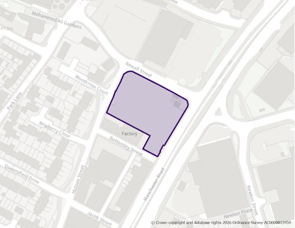
Site Size (ha) Gross: 0.37
Net Developable Area (ha): 0.37
Proposed Land Use: Employment (Eg(iii))
Site Type: PDL
Ward: Little Horton
Settlement: Bradford South West
Ownership: Mixed
Delivery Timescale: 2030-2035
Site Specific Requirements:
Site Access, Highways and Transport
- A new access would be required from Hutson Street.
Flooding, Water and Drainage
- It should be appropriate to develop this site for more vulnerable purposes given its location largely within Flood Zone 1 and nominal surface water flood risk. Ideally, all development would be directed to the area of the site within Flood Zone 1. However, detailed flood modelling of Bowling Beck would be required at the site-specific FRA to confirm onsite flood depths, velocities and hazards for both present day and for the impacts of climate change.
- The detailed model should also be used to understand whether there may be any impacts to the site as a result of a blockage of the Bowling Beck culvert to the east of the site.
- This site cannot be developed until the required information detailed in the SFRA on existing and future flood risk from Bowling Beck is fully ascertained.
Environmental Protection
- This site is located within the Clean Air Zone and development must be in accordance with the requirements set out in Policy CR1.
- Due to its former use, there may be land contamination which would require remediation.
- The site is adjacent to residential dwellings, giving rise to potential impacts from employment uses. Relevant assessments should be provided to determine the nature and extent of any impacts together with appropriate mitigation measure as part of any planning application.
- The design and layout of development should not compromise the operation of existing residential uses and ensure that the amenity of future occupiers is protected.
Open Space and Green / Blue Infrastructure
- The site lies within the Bradford City CentreOpportunity Area, as identified in the Green and Blue Infrastructure Strategy (GBIS). The strategy should be consulted to identify opportunities for incorporating measures within the development that enhance the quality of, and connectivity to, the green and blue infrastructure network in this area.
- Site is within/partially within an area of medium provision and high need for green and blue infrastructure. Development proposals should focus on carefully designed green and blue infrastructure to contribute towards site specific issues e.g. flood mitigation, urban cooling, etc.
- Where appropriate, the site should seek to provide on-site open space in line with Policy NE2.
Infrastructure Requirements
- Proportionate contributions to community infrastructure will be required, where appropriate, in line with Policies ID1 and ID2, and having regard to the Local Infrastructure Plan.
E76: Former Rushworth Works, Beckside Road Comment
Site Boundary:
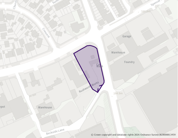
Site Size (ha) Gross: 0.24
Net Developable Area (ha): 0.24
Proposed Land Use: Employment (Eg(iii))
Site Type: PDL
Ward: Great Horton
Settlement: Bradford South West
Ownership: Private
Delivery Timescale: 2030-2035
Site Specific Requirements:
Site Access, Highways and Transport
- An improved access from Beckside Road will be required.
Flooding, Water and Drainage
- There should be no development above the West Brook culvert which runs beneath the site. The location and path of this culvert should be confirmed through a survey as part of the site-specific FRA.
- There may be opportunities to deculvert and daylight the West Brook culvert beneath the site which could impact flood risk on the site. Any site-specific FRA should produce a detailed model of the reach of West Brook to confirm modelled flood extents and depths within the site.
- Given the extent of surface water flood risk in the low risk event, a full drainage strategy would be required to ensure there is no increase in surface water flood risk elsewhere as a result of new development. This will require surface water modelling based on layout plans and detailed design and full consultation with the LLFA. Runoff volumes must not exceed existing brownfield rates and, if possible, betterment should be achieved. An area-wide drainage strategy or Surface Water Management Plan should be considered.
- This site cannot be developed until the required information detailed in the SFRA on existing and future surface water flood risk is fully ascertained.
- Groundwater conditions within the north of the site should be investigated further through the site-specific FRA to ascertain groundwater levels and conditions.
Environmental Protection
- This site is located within the Clean Air Zone and development must be in accordance with the requirements set out in Policy CR1.
- Due to its former use, there may be land contamination which would require remediation.
Open Space and Green / Blue Infrastructure
- Site is within an area of medium provision and high need for green and blue infrastructure. Development proposals should focus on carefully designed green and blue infrastructure to contribute towards site specific issues e.g. flood mitigation, urban cooling, etc.
- Where appropriate, the site should seek to provide on-site open space in line with Policy NE2.
Infrastructure Requirements
- Proportionate contributions to community infrastructure will be required, where appropriate, in line with Policies ID1 and ID2, and having regard to the Local Infrastructure Plan.
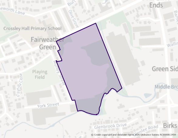
Site Size (ha) Gross: 6.82
Net Developable Area (ha): 5.11
Proposed Land Use: Employment
Site Type: PDL
Ward: Clayton and Fairweather Green
Settlement: Bradford South West
Ownership: Private
Delivery Timescale: 2030-2035
Site Specific Requirements:
Planning Permission
- Site benefits from planning permission for 7 industrial units and an outline application for the construction of 9 Industrial units of varying sizes, use class for the development will be B2, B8 and Eiii with ancillary offices (23/04496/MAF) granted on 15th January 2026. This was after 1 April 2025 (the base date for the Local Plan). Accordingly, it has been identified as a site allocation. Development of this site should take place in line with the approved planning permission.
E83: Northside Road Comment
Site Boundary:
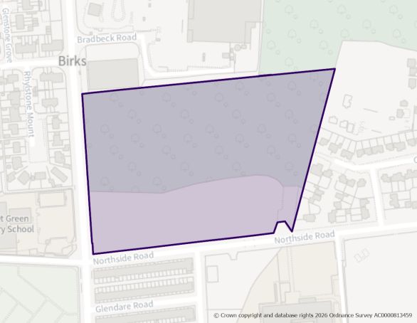
Site Size (ha) Gross: 4.47
Net Developable Area (ha): 3.35
Proposed Land Use: Employment
Site Type: PDL
Ward: Great Horton
Settlement: Bradford South West
Ownership: Private
Delivery Timescale: 2030-2035
Site Specific Requirements:
Site Access, Highways and Transport
- An improved access from Northside Road will be required.
Natural and Historic Environment
- Site is adjacent to identified Priority Habitat (Grassland) and within bat alert area. An ecology survey may be required at the planning application stage. Early engagement with the Council's Biodiversity Officer is recommended.
- The site is identified in the LNRS with the preferred measure B3_M03: Enhance the boundaries of brownfield sites.
Environmental Protection
- Site is located adjacent to a former landfill, which may pose contamination issues.
- Site is within a Mineral Safeguarding Area (MSA) for coal and sandstone. A mineral resource assessment will be required as part of any planning application to determine the extent and availability of any coal and sandstone resource.
- The site is adjacent to residential dwellings, giving rise to potential impacts from employment uses. Relevant assessments should be provided to determine the nature and extent of any impacts together with appropriate mitigation measure as part of any planning application.
- The design and layout of development should not compromise the operation of existing residential uses and ensure that the amenity of future occupiers is protected.
Open Space and Green / Blue Infrastructure
- Site is within/partially within an area of low provision and medium need for green and blue infrastructure. Development proposals should focus on carefully designed green and blue infrastructure to contribute towards site specific issues e.g. flood mitigation, urban cooling, etc.
Infrastructure Requirements
- Proportionate contributions to community infrastructure will be required, where appropriate, in line with Policies ID1 and ID2, and having regard to the Local Infrastructure Plan.
E85: Ingleby Road Comment
Site Boundary:
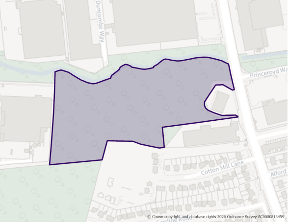
Site Size (ha) Gross: 3.25
Net Developable Area (ha): 2.93
Proposed Land Use: Employment (Eg(i), B2 and B8)
Site Type: Mixed
Ward: Great Horton
Settlement: Bradford South West
Ownership: Private
Delivery Timescale: 2035-2040
Site Specific Requirements:
Site Access, Highways and Transport
- A new access to Ingleby Road is required.
Flooding, Water and Drainage
- The following is required:
- Further modelling to understand the impacts of climate change on surface water flood risk to the site.
- A condition and capacity assessment of the culvert beneath the A6177.
- Consultation with the relevant reservoir owners to understand the impact of development on reservoir risk designation.
- FRA should be carried out in line with the latest versions of the NPPF; FRCC-PPG; EA guidance; the CBMDC Local Plan and national and local SuDS policy and guidelines.
- Throughout the FRA process, consultation should be carried out with the following, where applicable, the local planning authority; the lead local flood authority; emergency planning officers; the Environment Agency; Yorkshire Water; the highways authorities; and the emergency services.
Natural and Historic Environment
- Site is within an identified Wildlife Habitat Network (Grassland) and adjacent to a Wildlife Habitat Network (Wetland) and partially within a bat alert area. An ecology survey may be required at the planning application stage. Early engagement with the Council's Biodiversity Officer is recommended.
- The site is identified in the LNRS with the preferred measure B2_M04: Significantly boost the quality of existing blue and green habitat corridors and stepping stones within urban spaces.
- The site is located within a bat alert area. An ecological survey will be required as part of any planning application to establish the extent/impacts as well as to identify appropriate mitigation.
Environmental Protection
- Site is located adjacent to a former landfill, which may pose contamination issues.
- Site is within a Mineral Safeguarding Area (MSA) for coal and sandstone. A mineral resource assessment will be required as part of any planning application to determine the extent and availability of any coal and sandstone resource.
Open Space and Green / Blue Infrastructure
- The site lies within the Bradford City CentreOpportunity Area, as identified in the Green and Blue Infrastructure Strategy (GBIS). The strategy should be consulted to identify opportunities for incorporating measures within the development that enhance the quality of, and connectivity to, the green and blue infrastructure network in this area.
- Site is partially within an area of low provision and medium need for green and blue infrastructure. Development proposals should focus on carefully designed green and blue infrastructure to contribute towards site specific issues e.g. flood mitigation, urban cooling, etc.
- Where appropriate, the site should seek to provide on-site open space in line with Policy NE2.
Infrastructure Requirements
- Proportionate contributions to community infrastructure will be required, where appropriate, in line with Policies ID1 and ID2, and having regard to the Local Infrastructure Plan.
