

Bradford District Local Plan - Publication Draft (Regulation 19) (October 2026)
Policy SP1: Shipley
Introduction
Shipley is located approximately 5km to the North of Bradford City Centre on the A650, the main transport route connecting Keighley to Bradford. The area forms part of the northern fringes of the Regional City and gateway to Airedale. Shipley is a mixed area with large residential suburbs, employment and retail areas with an important town centre. It has excellent rail connectivity offering short journey times from Shipley Station to Bradford City Centre and Leeds and onward rail connections.
The Town Centre is the focal point for the provision of shopping, leisure and public services, which caters for local needs. Within close proximity to the town centre is the World Heritage Site of Saltaire and significant employment areas, including am industrial and office cluster around Dockfield Road. Salt’s Mill, the focal point of Saltaire, is a high-quality example of the area’s architectural heritage and there are clusters of attractive historic buildings around the fringes of the Town Centre and the Leeds and Liverpool Canal.
Shipley has an established strategic long term non-statutory Development Framework and Towns Fund vision with a focus upon a revitalised better connected town centre with increased levels of town centre living, improving access to green spaces, Bradford Beck and canal together with an enhanced public realm and making the most of supporting technology and creative businesses. The Shipley Regeneration Area (RA11) identified in this plan generally follows the Town Centre / civic quarter, the creative canalside quarter and part of Shipley Riverside as set out in the Development Framework.
Vision for Shipley
Shipley, the gateway to Airedale, will be revitalised to be a people and family-focused Town Centre, with a diverse and creative offering. It will combine World-class heritage and culture alongside quality amenities, parks and public spaces which are well connected together, making it easy for visitors to experience all that Shipley has to offer – both within Saltaire and the wider Shipley area.
Access to Shipley’s Canal and River will be opened up to create new public realm, spaces to dwell and enjoy and new waterside housing developments, making the most of repurposing Shipley’s industrial heritage.
Shipley will continue to be a ‘making place’, maximising the area’s manufacturing assets and wealth of talent, to innovate and grow, creating a thriving and sustainable neighbourhood within the Regional City of Bradford.
(Shipley Development Framework – June 2024)
POLICY SP1 - SHIPLEY Comment
Settlement Plan
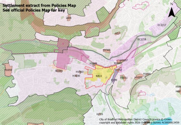
Settlement Hierarchy and Spatial Directions
- Shipley is defined on the Policies Map and forms part of the Regional City.
- Housing growth will be focused upon maximising opportunities for the reuse of brownfield sites for new housing within its settlement boundary and the sensitive western extension of the settlement along Bingley Road to widen the range of family housing.
- Deliver a thriving sustainable town centre making the most of its strategic location as an attractive gateway to Saltaire and Airedale, with excellent public transport connectivity while supporting businesses to grow and delivering new high-quality housing.
- Broaden the diversity, tenure and quality of housing within Shipley with opportunities to attract new residents benefiting from rail connectivity, an enhanced town centre and family focused environment.
- A range of housing types will be encouraged to provide a range of unit sizes, including mid to-high density apartment buildings and mid to-lower density townhouse terraces, together with the conversion of existing buildings including residential uses within the upper level of commercial buildings.
- Continue to support local businesses and economic sector specialisms including advanced manufacturing, engineering and creative industries to include an extended Employment Zone EC2/18 Otley Road / Thackley Old Road.
- Further development of new employment opportunities to the east of the railway line and Bradford Beck.
- Support Shipley Market and the wider market town economy and its role in creating an inclusive community facilitating growth in visitors and connectivity to Saltaire and the wider area.
Meeting Growth Needs
- Housing development in Shipley will deliver approximately 1,229 dwellings through a combination of sites within the urban area and land released from the Green Belt from sites under construction, with planning permission and new site allocations during the plan period, together with additional supply from a town centre regeneration area as set out in Table SP1.1
Table SP1.1 – Shipley Housing Delivery
|
Under Construction |
Planning Permission |
Site Allocations |
Regen Area |
|
|
Totals |
316 |
61 |
602 |
250 |
- Deliver housing site allocations as shown on the Policies Map and the site proformas within section 5. Proposals for new homes within the settlement boundary on additional small sites outside of the Town Centre, including the redevelopment of previously developed land, will also be supported subject to meeting policies HO3 and DS3.
- To help meet employment needs 1.24ha of employment land is allocated at Crag Road for B1 / B8 uses.
- Approach to delivery:
- Market-led approach to delivery of development on housing site allocations – working with developers and registered providers to secure quality housing schemes.
- Market-led approach to employment site development and intensification of employment opportunities within the Employment Zone (EC2/18).
- Regeneration focused growth within the Shipley Regeneration Area (RA11) – introducing a station linked growth strategy with new mixed-use development and creating a better-connected active travel hub at the station together with limited infill development for new homes, redevelopment of under-utilised land and changes of uses with the wider regeneration area.
Local Services and Facilities
- Support a positive approach to Shipley Town Centre through strengthening its commercial offer and vitality as an important Town Centre and Primary Shopping Area as defined on the Policies Map, and by enhancing its diverse range of retail, service and leisure uses, range of independent businesses and growing evening economy sector.
- Continue to support the retention of independent businesses and small -scale commercial premises within the Saltaire District Centre as defined on the Policies Map.
- Existing open spaces, and green and blue infrastructure, will be protected and enhanced to support the delivery of the opportunities identified in the GBI Keighley / Bingley / Shipley Focus Area and play a key role in place shaping over the plan period. New developments will provide accessible multifunctional open space for existing and new communities within the city centre. These should help to create a network of green corridors to connect habitats and improve ecology both within the city centre and wider corridors.
- Maintain and enhance sport and recreation facilities with support for widened community access.
Townscape and Landscape
- Improve connectivity and permeability within the Town Centre and through to surrounding neighbourhoods with public realm enhancements and links to the canal and riverside.
- Retain local distinctiveness and townscape features through the sensitive use and reuse of industrial architecture and historic buildings.
- Main and improve connectivity to the Saltaire WHS.
- Maintain and enhance the landscape setting, landscape features including scenic woodland backdrop to Saltaire, fields and overall settlement pattern.
Historic and Natural Environment
- Ensure the highest level of protection, management and enhancement of the Saltaire World Heritage Site and for development within the buffer zone conserve those elements which contribute towards its Outstanding Universal Value (OUV), including its setting and key views, in line with national policy and Policy NE1.
- Continue to ensure that future development conserves and enhances key heritage assets and their settings within and adjacent to the settlement including three Conservation Areas and large number of Listed Buildings as well as non-designated heritage assets.
- Support the retention and enhancement of a network of green and blue infrastructure including the River Aire and Leeds and Liverpool Canal; Shipley Glen to Baildon Moor to the North, along the Bradford Beck, South around Northcliffe Park and West towards Cottingley and Bingley.
- Developments should maintain and improve air quality to protect human health, wellbeing and the environment, within the Clean Air Zone falling within the central and western sections of Shipley.
- Where development is located within SPA/SAC Zone C (Recreational Pressure) residential development resulting in a net increase in dwellings will be required to mitigate any recreational pressure on the SPA/SAC caused by such development on accordance with the South Pennine Moors SPD and Policy NE3.
Local Infrastructure
- Create a more direct pedestrian and cyclist link between the Town Centre and Shipley Station.
- Support implementation of the Bradford to Shipley Route Improvement Scheme (BSRIS).
- The implementation of the West Yorkshire Transport Plan will secure a high-quality public transport network for the Regional City including Shipley, along with a comprehensive and attractive network for walking, wheeling and cycling, including secure cycle parking, to improve the environment for residents, businesses and visitors.
- Proportionate contributions towards improvements in community infrastructure, including consideration of additional education, healthcare and recreation provision as a result of an increased residential population.
- Where appropriate funding and delivery opportunities are available support investment in Shipley Pool & Gym facilities.
Shipley: Site Allocations
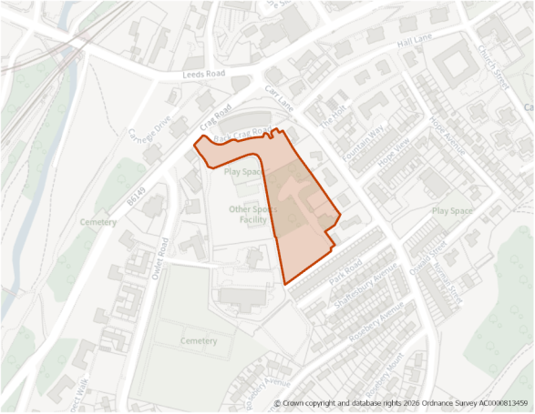
Site Size (ha) Gross: 1.10
Proposed Land Use: Housing
Minimum Development Capacity (Dwellings): 50
Site Type: Greenfield
Ward: Windhill & Wrose
Settlement: Shipley
Ownership: Mixed
Delivery Timescale: Long 2035+ (11+)
Site Specific Requirements:
Design Principles
- Development should provide at least 50 dwellings as part of a high-quality built environment in line with Policies ST4 and DS1, at a net density of 50 dph in line with Policy HO2. This should include affordable housing (in line with Policy HO4 and an appropriate mix of dwellings (in line with Policy HO3 and having due regard relevant housing needs evidence and the character of the area).
Site Access, Highways and Transport
- The access points off Crag Road, via Back Crag Road and off Carr Lane via Back Park Road will require improvements to appropriate standards and to mitigate with traffic generated from the larger Shipley Exchange site.
Natural and Historic Environment
- The site is in the World Heritage Buffer zone with potential impact on important views.
- A Heritage Impact Assessment (HIA) has been carried out for this site and indicates that the site should be carefully informed in terms of development scale and materials by the local palette and all mature trees and green landscaping should be retained.
- There is no impact on the outstanding universal value and no impact on the character and setting of the World Heritage site.
- There are mature trees on site near Windhill Recreation ground.
- Ecology survey - a walkover survey may be required.
- Part of the site is within a bat alert area. An ecological survey will be required as part of any planning application to establish the extent/impacts as well as to identify appropriate mitigation.
- The site lies within Zone C (Recreational Pressure) - Residential development resulting in a net increase in dwellings will be required to mitigate any recreational pressure on the SPA/SAC caused by such development in accordance with the South Pennine Moors SPD and Policy NE3.
- Part of the site is identified in the LNRS with the preferred measure B3_M01: Species-rich brownfield and other previously developed sites, encourage temporary (so-called ‘meanwhile-use’, in planning terms) nature-rich uses on undeveloped smaller non-phased brownfield sites (of more than 0.25 hectares) or on land being used for larger phased developments (more than five hectares),
and preferred measure B3_M02: Enhance (rather than replace) existing habitats on some areas of brownfield.
Environmental Protection
- Site lies partly within 150m buffer of a former landfill site. A Land Contamination Assessment – Phase 1 Report will be required as part of any planning application
- Site is within a Mineral Safeguarding Area (MSA) for Sandstone. A mineral resource assessment will be required as part of any planning application to determine the extent and availability of any sandstone resource.
- The site was historically used as unspecified works, industrial works, vehicle testing station giving rise for potential land contamination. A Land Contamination Assessment – Phase 1 Report will be required as part of any planning application. Impacts should be addressed in line with Policy CR2.
- Utilities – The site is within the buffer zone for a high voltage electricity transmission underground cable.
Landscape
- The site is partly within the Central Airedale Settled Floor Pasture Landscape Character area/type (G2). The site is within the settlement and no landscape sensitivity assessment was undertaken for this site. Consideration should be given to the guidance set out in the Landscape Character Assessment SPD.
Open Space and Green / Blue Infrastructure
- The northern part of the site is currently used as amenity greenspace, consideration should be given to retaining this open space or making alternative provision within the site, in line with policy NE2 and having regard to standards outlined in Appendix 11. The Open Space Assessment indicates that in Shipley there is a need for increased provision of amenity greenspace and parks.
- Site is adjacent to Windhill Recreation ground.
- Site is partially within an area of low provision and high need for green and blue infrastructure. Development proposals should focus on carefully designed green and blue infrastructure to contribute towards site specific issues e.g. flood mitigation, urban cooling, etc.
Infrastructure Requirements
- Proportionate contributions to community infrastructure will be required, where appropriate, in line with Policies ID1 and ID2, and having regard to the Local Infrastructure Plan.
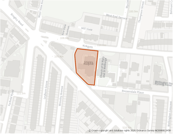
Site Size (ha) Gross: 0.21
Proposed Land Use: Housing
Minimum Development Capacity (Dwellings): 16
Site Type: PDL
Ward: Shipley
Settlement: Shipley
Ownership: Private
Delivery Timescale: Short 2025- 2030 (1-5)
Site Specific Requirements:
Design Principles
- Development should provide at least 16 dwellings as part of a high-quality built environment in line with Policies ST4 and DS1, at a net density of 75 dph in line with Policy HO2. This should include affordable housing (in line with Policy HO4 and an appropriate mix of dwellings (in line with Policy HO3 and having due regard relevant housing needs evidence and the character of the area).
Site Access, Highways and Transport
- Site access from Kirkgate.
- Within 800m buffer zone of Saltaire station.
Natural and Historic Environment
- Tree Preservation Orders to tree and woodland on site (to western / southwestern / southern boundaries). Adjacent to TPO woodland (1 no. group to northeastern boundary).
- The site is located within the Saltaire World Heritage Site (WHS) Buffer Zone. Development should be informed by the local context and regard should be had to the WHS Management Plan.
- The site lies within Zone C (Recreational Pressure) - Residential development resulting in a net increase in dwellings will be required to mitigate any recreational pressure on the SPA/SAC caused by such development in accordance with the South Pennine Moors SPD and Policy NE3.
Open Space and Green / Blue Infrastructure
- Open space should be provided in line with Policy NE2, having regard to the standards set out Appendix 11. The Open Space Assessment indicates that in Shipley there is a need for increased provision of park and amenity greenspace.
- The site lies within the GBI Focus Area: Keighley – Bingley – Shipley Corridor, as identified in the Green and Blue Infrastructure Strategy (GBIS). The strategy should be consulted to identify opportunities for incorporating measures within the development that enhance the quality of, and connectivity to, the green and blue infrastructure network in this area.
Landscape
- The site is within the Central Airedale Settled Floor Pasture Landscape Character area/type (G2). The site is within the settlement and no landscape sensitivity assessment was undertaken for this site. Consideration should be given to the guidance set out in the Landscape Character Assessment SPD.
Environmental Protection
- This site is located within the Clean Air Zone and development must be in accordance with the requirements set out in Policy CR1.
- The site was historically used as a hospital, giving rise for potential land contamination. A Land Contamination Assessment – Phase 1 Report will be required as part of any planning application. Impacts should be addressed in line with Policy CR2.
- Site is within 150m buffer of a former landfill site. A Land Contamination Assessment – Phase 1 Report will be required as part of any planning application.
- Site is within a Mineral Safeguarding Area (MSA) for Sandstone. A mineral resource assessment will be required as part of any planning application to determine the extent and availability of any sandstone resource.
Infrastructure Requirements
- Proportionate contributions to community infrastructure will be required, where appropriate, in line with Policies ID1 and ID2, and having regard to the Local Infrastructure Plan.
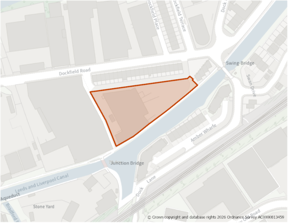
Site Size (ha) Gross: 0.41
Proposed Land Use: Housing
Minimum Development Capacity (Dwellings): 75
Site Type: PDL
Ward: Shipley
Settlement: Shipley
Ownership: Private
Delivery Timescale: Medium 2030-2035 (6-10)
Site Specific Requirements:
Design Principles
- Development should provide at least 75 dwellings as part of a high-quality built environment in line with Policies ST4 and DS1, at a net density of 75 dph in line with Policy HO2. This should include affordable housing (in line with Policy HO4 and an appropriate mix of dwellings (in line with Policy HO3 and having due regard relevant housing needs evidence and the character of the area).
- The site design should have regard to the listed canal frontage and provide a buffer along the Southern edge. It should include elements to create and maintain habitat corridors and provide stepping stones to connect and extend existing blue and green places.
- The layout, design and scale of dwellings should have regard to the proximity of the character of the surrounding area, taking into account the site’s topography, position in the landscape, and views into and out of the Conservation Area.
Site Access, Highways and Transport
- A new site access required. This would lead to Dockfield Road.
- A Public Right of Way ( Footpath Shipley 2) runs along the southern site boundary. This should be retained as part of any future development.
Flooding, Water and Drainage
- Development should be possible at this site given the low fluvial and very low surface water flood risk to the site.
- Given the change in use and therefore vulnerability of the site, the FRA must show that the development can be designed to be safe and that there is adequate emergency planning provision.
- Any change in site layout where there are changes to current building footprints or road layouts, will require detailed surface water modelling to ascertain flow routes and low-lying areas.
Natural and Historic Environment
- The site lies within Zone C (Recreational Pressure) - Residential development resulting in a net increase in dwellings will be required to mitigate any recreational pressure on the SPA/SAC caused by such development in accordance with the South Pennine Moors SPD and Policy NE3.
- The site is immediately adajcent to the Leeds and Liverpool Canal Local Wildlife Site. The layout and design of any development include an appropriate buffer area along its southern boundary. The site is located within a bat alert area. An ecological survey will be required as part of any planning application to establish the extent/impacts as well as to identify appropriate mitigation.
- Site is within a Conservation Area and within proximity to Grade II Canal Bridge No 208 ( Leeds And Liverpool Canal). The layout, design and scale of dwellings should have regard to the proximity of the character of the surrounding area, taking into account the site’s topography, position in the landscape, and views into and out of the Conservation Area. As well as other designated and non-designated heritage assets that are in the vicinity of the site Dockfield Mills, Junction Mills.
- The site is located within the Saltaire World Heritage Site (WHS) Buffer Zone. Development should be informed by the local context and regard should be had to the WHS Management Plan.
- The site is identified in the LNRS with the preferred measure Priority B2: Blue and green links rich in nature through, between and beyond towns and cities, and preferred measure B2_M01: Create and maintain habitat corridors and stepping stones to connect and extend existing blue and green places.
Environmental Protection
- Site lies partly within 150m buffer of a former landfill site. A Land Contamination Assessment – Phase 1 Report will be required as part of any planning application.
- The site was historically used as mills/textile mills, unspecified works, giving rise for potential land contamination. A Land Contamination Assessment – Phase 1 Report will be required as part of any planning application. Impacts should be addressed in line with Policy CR2.
- The site is adjacent to a consultation zone for a high-pressure gas pipeline. Design and layout of any development should ensure that appropriate clearances are taken into consideration. Consultation should take place with the Health and Safety Executive, National Gas and Northern Gas Networks, as appropriate.
Landscape
- The site is within the Central Airedale Settled Floor Pasture Landscape Character area/type (G2). The site is within the settlement and no landscape sensitivity assessment was undertaken for this site. Consideration should be given to the guidance set out in the Landscape Character Assessment SPD.
Open Space and Green / Blue Infrastructure
- Open space should be provided in line with Policy NE2, having regard to the standards set out Appendix 11. The Open Space Assessment indicates that in Shipley there is a need for increased provision of park and amenity greenspace.
- The site lies within the GBI Focus Area: Keighley – Bingley – Shipley Corridor, as identified in the Green and Blue Infrastructure Strategy (GBIS). The strategy should be consulted to identify opportunities for incorporating measures within the development that enhance the quality of, and connectivity to, the green and blue infrastructure network in this area.
Infrastructure Requirements
- Proportionate contributions to community infrastructure will be required, where appropriate, in line with Policies ID1 and ID2, and having regard to the Local Infrastructure Plan.
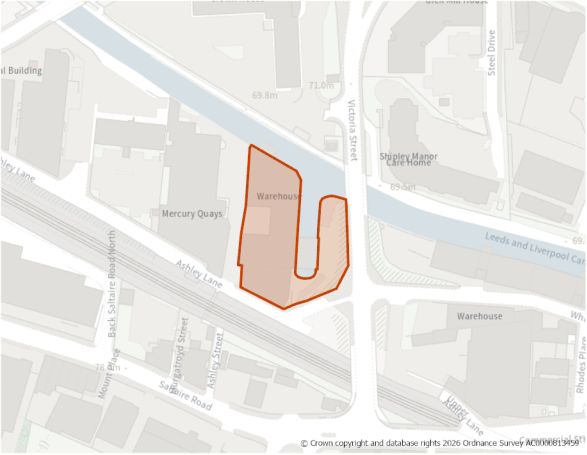
Site Size (ha) Gross: 0.30
Proposed Land Use: Housing
Minimum Development Capacity (Dwellings): 45
Site Type: PDL
Ward: Shipley
Settlement: Shipley
Ownership: Private
Delivery Timescale: Long 2035+ (11+)
Site Specific Requirements:
Design Principles
- Development should provide at least 45 dwellings as part of a high-quality built environment in line with Policies ST4 and DS1, at a net density of 150 dph in line with Policy HO2. This should include affordable housing (in line with Policy HO4 and an appropriate mix of dwellings (in line with Policy HO3 and having due regard relevant housing needs evidence and the character of the area).
- This site is on a critical approach to the Saltaire World Heritage Site and within an Important Gateway and also adjacent to the Leeds Liverpool Canal conservation Area.
- Conversion of the buildings would be preferred to re-development of the site. However, if the site is to be comprehensively re developed the design of the resulting buildings should reflect the previous use and canalside character, opening up views within the world heritage site.
Site Access, Highways and Transport
- A new access is required, this would lead to Ashley Lane. The road is narrow and will need improvement.
- Victoria Street has cycle and pedestrian access however direct access for vehicles is unlikely to be acceptable.
Flooding, Water and Drainage
- SFRA level 2 recommendations: It should be appropriate to develop this site for more vulnerable purposes given its location in Flood Zone 1. Development should avoid the existing area of the Leeds and Liverpool Canal on site. Built development should not be situated within 8m of the canal to allow for maintenance access.
- Surface water should be retained onsite. This will require detailed surface water modelling based on layout plans and detailed design and full consultation with the LLFA on required runoff rates, likely to be greenfield or betterment. The use of infiltration SuDS should be investigated across the majority of the site.
Natural and Historic Environment
- The site lies within Zone C (Recreational Pressure) - Residential development resulting in a net increase in dwellings will be required to mitigate any recreational pressure on the SPA/SAC caused by such development in accordance with the South Pennine Moors SPD and Policy NE3.
- The site is within a bat alert area. An ecological survey will be required as part of any planning application to establish the extent/impacts as well as to identify appropriate mitigation.
- The site is within world heritage site buffer and within Leeds Liverpool Canal conservation Area. It is partly within 50m buffer of Listed building – Grade 11 Canal Warehouse, Wharfe Street whic lies to the East og the site.
- The former Canal Company Warehouse is a non designated heritage asset.
- A Heritage Impact Assessment (HIA) has been carried out for this site and indicates thatthe preferred approach is the sympathetic conversion of the Canal Company Warehouse. This would positively enhance the character and setting of the building, Leeds Liverpool Conservation Area and wider setting of the World Heritage Site.
- Loss of the Canal Company warehouse should only be considered as a last option. Any redevelopment of this site would need to be sympathetically informed by the context and heritage of the site and conservation area. The design, scale, massing and material usage of any new development would need to be informed by the neighbouring warehouses along the wharf and preserve or enhance the site and conservation area.
- The site, excluding the water, is identified in the LNRS with the preferred measure B3_M01: Encourage temporary (so-called ‘meanwhile-use’, in planning terms) nature-rich uses on undeveloped smaller non-phased brownfield sites (of more than 0.25 hectares) or on land being used for larger phased developments (more than five hectares); At the water’s edge (bottom of U shape), preferred measure Q2_M01: Significantly enhance the quality of the habitats in existing Local Wildlife Sites, supported by ongoing monitoring and maintenance.
Landscape
- The site is within the Central Airedale Settled Floor Pasture Landscape Character area/type (G2). The site is within the settlement and no landscape sensitivity assessment was undertaken for this site. Consideration should be given to the guidance set out in the Landscape Character Assessment SPD.
Environmental Protection
- This site is located within the Clean Air Zone and development must be in accordance with the requirements set out in Policy CR1.
- Site lies partly within the 150m buffer of a former landfill site. A Land Contamination Assessment – Phase 1 Report will be required as part of any planning application.
- Site is within a Mineral Safeguarding Area (MSA) for Sandstone. A mineral resource assessment will be required as part of any planning application to determine the extent and availability of any sandstone resource.
- The site was historically used as a stone yard, unspecified works, warehouses, wharves, textile mill (Ashley Mill), giving rise for potential land contamination. A Land Contamination Assessment – Phase 1 Report will be required as part of any planning application. Impacts should be addressed in line with Policy CR2.
Open Space and Green / Blue Infrastructure
- Open space should be provided in line with Policy NE2, having regard to the standards set out Appendix 11. The Open Space Assessment indicates that in Shipley there is a need for increased provision of park and amenity greenspace.
- The site lies within the GBI Focus Area: Keighley – Bingley – Shipley Corridor, as identified in the Green and Blue Infrastructure Strategy (GBIS). The strategy should be consulted to identify opportunities for incorporating measures within the development that enhance the quality of, and connectivity to, the green and blue infrastructure network in this area.
Infrastructure Requirements
- Proportionate contributions to community infrastructure will be required, where appropriate, in line with Policies ID1 and ID2, and having regard to the Local Infrastructure Plan.
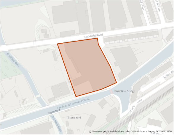
Site Size (ha) Gross: 0.69
Proposed Land Use: Housing
Minimum Development Capacity (Dwellings): 93
Site Type: PDL
Ward: Shipley
Settlement: Shipley
Ownership: Private
Delivery Timescale: Medium 2030-2035 (6-10)
Site Specific Requirements:
Design Principles
- Development should provide at least 93 dwellings as part of a high-quality built environment in line with Policies ST4 and DS1, at a net density of 75 dph in line with Policy HO2. This should include affordable housing (in line with Policy HO4 and an appropriate mix of dwellings (in line with Policy HO3 and having due regard relevant housing needs evidence and the character of the area).
- The design should make improvements to existing footpath and cycle links within and through the site to existing networks.
- The site is immediately adajcent to the Leeds and Liverpool Canal Local Wildlife Site. The layout and design of any development should include an appropriate buffer area along its southern boundary and should take account of the sites proximity to the adjacent wildlife site.
- Development should provide appropriate and proportionate improvements to the canal towpath and the Junction Road footpath.
- Development will be expected to safeguard and enhance the setting of the Leeds and Liverpool Conservation Area and Site of Ecological and Geographical Importance and key heritage assets including, grade 2 listed Junction Bridge and the unlisted mill buildings and provide a high-quality frontage to the canal.
Site Access, Highways and Transport
- New site access required. This would lead to Dockfield Road.
- A Public Right of Way ( Footpath Shipley 2) runs along the southern site boundary. This should be retained as part of any future development.
- Improvements to pedestrian and cycle links within and through the site to existing networks, including to the canal towpath, would help to connect the development to the surrounding area and encourage walking and cycling.
Flooding, Water and Drainage
- Further modelling to understand the impacts of climate change on surface water flood risk to the site. A condition assessment of the bridge beneath Dockfield to the north-east of the site. Consultation with the relevant reservoir owners to understand the impact of development on reservoir risk designation. Any Flood Risk Assessment, (FRA), should be carried out in line with the latest versions of the National Planning Policy Framework; Flood Risk and Coastal Change Planning Practice Guidance; Environment Agency guidance; the City of Bradford Metropolitan District Council Local Plan and national and local Sustainable urban Drainage Systems policy and guidelines. Throughout the FRA process, consultation should be carried out with the following, where applicable, the local planning authority; the lead local flood authority; emergency planning officers; the Environment Agency; Yorkshire Water; the highways authorities; and the emergency services.
Natural and Historic Environment
- The site lies within Zone C (Recreational Pressure) - Residential development resulting in a net increase in dwellings will be required to mitigate any recreational pressure on the SPA/SAC caused by such development in accordance with the South Pennine Moors SPD and Policy NE3.
- The site is immediately adajcent to the Leeds and Liverpool Canal Local Wildlife Site. The layout and design of any development include an appropriate buffer area along its southern boundary. The site is located within a bat alert area. An ecological survey will be required as part of any planning application to establish the extent/impacts as well as to identify appropriate mitigation.
- Site is within a Conservation Area and within proximity to Grade II Canal Bridge No 208, (Leeds And Liverpool Canal). The layout, design and scale of dwellings should have regard to the proximity of the character of the surrounding area, taking into account the site’s topography, position in the landscape, and views into and out of the Conservation Area. As well as other designated and non-designated heritage assets that are in the vicinity of the site Dockfield Mills, Junction Mills.
- The site is located within the Saltaire World Heritage Site (WHS) Buffer Zone. Development should be informed by the local context and regard should be had to the WHS Management Plan.
- The site is identified in the LNRS with the preferred measure B3_M01: Encourage temporary (so-called ‘meanwhile-use’, in planning terms) nature-rich uses on undeveloped smaller non-phased brownfield sites (of more than 0.25 hectares) or on land being used for larger phased developments (more than five hectares).
Landscape
- The site is within the Central Airedale Settled Floor Pasture Landscape Character area/type (G2). The site is within the settlement and no landscape sensitivity assessment was undertaken for this site. Consideration should be given to the guidance set out in the Landscape Character Assessment SPD.
Environmental Protection
- Site within 150m buffer of a former landfill site. A Land Contamination Assessment – Phase 1 Report will be required as part of any planning application.
- The site was historically used as a mills/textile mills, depot, unspecified works, warehouses, blacksmiths, gas works, envelope factory, giving rise for potential land contamination. A Land Contamination Assessment – Phase 1 Report will be required as part of any planning application. Impacts should be addressed in line with Policy CR2.
- The site is crossed on the northern boundary by a high-pressure gas pipeline. Design and layout of any development should ensure that appropriate clearances are taken into consideration. Consultation should take place with the Health and Safety Executive, National Gas and Northern Gas Networks, as appropriate.
Open Space and Green / Blue Infrastructure
- Open space should be provided in line with Policy NE2, having regards to the standards set out Appendix 11. The Open Space Assessment indicates that in Shipley there is a need for increased provision of park and amenity greenspace.
- The site lies within the GBI Focus Area: Keighley – Bingley – Shipley Corridor, as identified in the Green and Blue Infrastructure Strategy (GBIS). The strategy should be consulted to identify opportunities for incorporating measures within the development that enhance the quality of, and connectivity to, the green and blue infrastructure network in this area.
Infrastructure Requirements
- Proportionate contributions to community infrastructure will be required, where appropriate, in line with Policies ID1 and ID2, and having regard to the Local Infrastructure Plan.
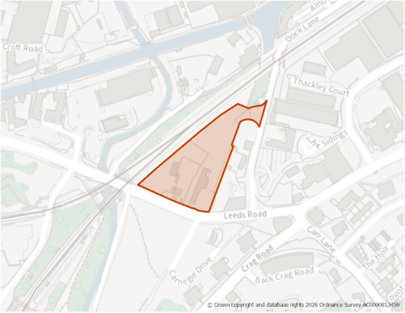
Site Size (ha) Gross: 0.71
Proposed Land Use: Housing
Minimum Development Capacity (Dwellings): 48
Site Type: PDL
Ward: Windhill & Wrose
Settlement: Shipley
Ownership: Private
Delivery Timescale: Long 2035+ (11+)
Site Specific Requirements:
Design Principles
- Development should provide at least 48 dwellings as part of a high-quality built environment in line with Policies ST4 and DS1, at a net density of 75 dph in line with Policy HO2. This should include affordable housing (in line with Policy HO4 and an appropriate mix of dwellings (in line with Policy HO3 and having due regard relevant housing needs evidence and the character of the area).
Site Access, Highways and Transport
- The current existing access is to be used, leading to Dock Lane. There should be no new site access from Leeds Road. Close to Shipley station so pedestrian linkages will need to be incorporated.
Flooding, Water and Drainage
- Nominal risk report recommendations - The site is not required to pass the exception test as it is not located within Flood Zone 3a. The proposed development would see a change in the risk classification from less vulnerable to more vulnerable, according to the National Planning Policy Framework. Given the change in use and therefore vulnerability of the site, the Flood Risk Assessment, (FRA), must show that the development can be designed to be safe and that there is adequate emergency planning provision (para 014 Flood Risk and Coastal Change – Planning Practice Guidance). Based on available information, there is no additional risk to the site from reservoir, canal or sewer flooding. Development should be possible at this site given the low fluvial and very low surface water flood risk to the site. The site is not modelled to be at significant additional fluvial or surface water risk as a result of climate change.
Natural and Historic Environment
- The site is within bat alert area and adjacent to an identified Wildlife Habitat Network, (Wetland). An ecology survey may be required at the planning application stage and early engagement with the Council's Biodiversity Officer is recommended.
- The site lies within Zone C (Recreational Pressure) - Residential development resulting in a net increase in dwellings will be required to mitigate any recreational pressure on the SPA/SAC caused by such development in accordance with the South Pennine Moors SPD and Policy NE3.
- The site is identified in the LNRS with the preferred measure B3_M01: Encourage temporary (so-called ‘meanwhile-use’, in planning terms) nature-rich uses on undeveloped smaller non-phased brownfield sites (of more than 0.25 hectares) or on land being used for larger phased developments (more than five hectares).
- The majority of the site is within World Heritage Site (WHS) Buffer Zone. Development should be informed by the local context and regard should be had to the WHS Management Plan.
- Part of the site is within the Leeds Liverpool Canal Conservation Area.
Landscape
- The site is within the Central Airedale Settled Floor Pasture Landscape Character area/type (G2). The site is within the settlement and no landscape sensitivity assessment was undertaken for this site. Consideration should be given to the guidance set out in the Landscape Character Assessment SPD.
Environmental Protection
- This site is located within the Clean Air Zone and development must be in accordance with the requirements set out in Policy CR1.
- Site partly contains a former landfill. A Land Contamination Assessment – Phase 1 Report will be required as part of any planning application due determining any potential impacts. Impacts should be addressed in line with Policy CR2.
- Development will result in the loss of an operational waste management facility. Any proposal should meet the requirements set out in Policy WAS3.
- The site was historically used as railway land, giving rise for potential land contamination. A Land Contamination Assessment – Phase 1 Report will be required as part of any planning application. Impacts should be addressed in line with Policy CR2.
- Site is within a Mineral Safeguarding Area (MSA) for Sandstone. A mineral resource assessment will be required as part of any planning application to determine the extent and availability of any Sandstone resource.
- The site is within the buffer zone for a high voltage electricity transmission overground cable.
Open Space and Green / Blue Infrastructure
- Open space should be provided in line with Policy NE2, having regards to the standards set out Appendix 11. The Open Space Assessment indicates that in Shipley there is a need for increased provision of park and amenity greenspace.
- The site lies within the GBI Focus Area: Keighley – Bingley – Shipley Corridor, as identified in the Green and Blue Infrastructure Strategy (GBIS). The strategy should be consulted to identify opportunities for incorporating measures within the development that enhance the quality of, and connectivity to, the green and blue infrastructure network in this area.
Infrastructure Requirements
- Proportionate contributions to community infrastructure will be required, where appropriate, in line with Policies ID1 and ID2, and having regard to the Local Infrastructure Plan.
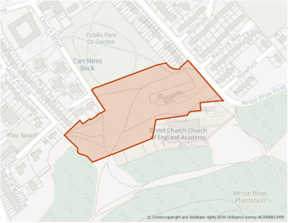
Site Size (ha) Gross: 1.99
Proposed Land Use: Housing
Minimum Development Capacity (Dwellings): 90
Site Type: Greenfield
Ward: Windhill & Wrose
Settlement: Shipley
Ownership: Private
Delivery Timescale: Long 2035+ (11+)
Site Specific Requirements:
Design Principles
- Development should provide at least 90 dwellings as part of a high-quality built environment in line with Policies ST4 and DS1, at a net density of 50 dph in line with Policy HO2. This should include affordable housing (in line with Policy HO4 and an appropriate mix of dwellings (in line with Policy HO3 and having due regard relevant housing needs evidence and the character of the area).
- The design and layout should be designed to not impact on the Character, setting or OUV of the World Heritage Site.
Site Access, Highways and Transport
- A new access would join Church Street.
- The site is adjacent to Public Right of Way (Shipley 10) at the north-eastern corner.
Natural and Historic Environment
- The site lies within Zone C (Recreational Pressure) - Residential development resulting in a net increase in dwellings will be required to mitigate any recreational pressure on the SPA/SAC caused by such development in accordance with the South Pennine Moors SPD and Policy NE3.
- The site is within a grassland habitat network and a bat alert area. An ecological survey will be required as part of any planning application to establish the extent/impacts as well as to identify appropriate mitigation.
- The site is identified in the LNRS with the preferred measure G1_M03: Restore and enhance existing species-rich grasslands, and T2_M04: Extend and connect tree and woodland cover across the White Rose Forest area in West Yorkshire to contribute to base target of 16.5 per cent and stretched target of 18.5 per cent by 2050 using 'right tree, right place' principles. Do independent ecological assessments to identify any conflicts with other habitat types and check the suitability of species, ensure compliance with regulatory control. Seek professional advice to help you do this (from the Forestry Commission, White Rose Forest, private sector woodland/forestry agents or independent ecologists who understand the importance of a broad range of habitats and species, including woodland).
- The site is located within the Saltaire World Heritage Site (WHS) Buffer Zone. Development should be informed by the local context and regard should be had to the WHS Management Plan.
- A Heritage Impact Assessment (HIA) has been carried out for this site and indicates that provided that the development is designed so as not to impact on the character, setting or Outstanding Universal Value of the Saltaire World Heritage Site, then it would be considered acceptable. This may include a reduced capacity for the site, a specific site configuration to avoid development on the upper part of the site and/or the use of particular dwelling types to ensure that the scale of development reflects the sensitivities of the location. Consultation with the Council’s Heritage team will be required at the planning application stage to ensure any negative impacts are effectively mitigated.
Environmental Protection
- Site lies partly within 150m buffer of a former landfill site. A Land Contamination Assessment – Phase 1 Report will be required as part of any planning application.
- Site is partially within a Development High Risk Area for coal mining, indicating that it contains one or more recorded former related features at surface or shallow depth. A Coal Mining Risk Assessment (CMRA) will be required as part of any planning application.
- The site was historically used as agricultural land, coal mining, giving rise for potential land contamination. A Land Contamination Assessment – Phase 1 Report will be required as part of any planning application. Impacts should be addressed in line with Policy CR2.
- Site is partially within a Mineral Safeguarding Area (MSA) for Coal. A mineral resource assessment will be required as part of any planning application to determine the extent and availability of any coal resource.
- The northern boundary of the site is within the buffer zone for a high voltage electricity transmission overground cable.
Open Space and Green / Blue Infrastructure
- The site is part of an area of amenity open space and replacement provision or improvements should be made through new development. Open space should be provided in line with Policy NE2, having regards to the standards set out in Appendix 11. The Open Space Assessment indicates that in Shipley there is a need for increased provision of park and amenity greenspace.
Other Constraints
- Part of the site is classed as Grade 4 and 3b on the Agricultural Land Classification (ALC).
Infrastructure Requirements
- Proportionate contributions to community infrastructure will be required, where appropriate, in line with Policies ID1 and ID2, and having regard to the Local Infrastructure Plan.
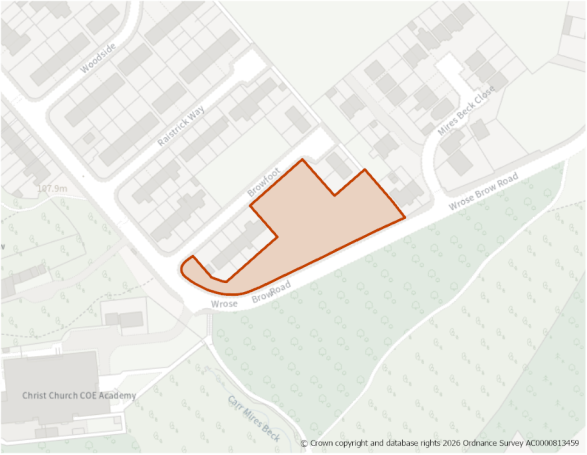
Site Size (ha) Gross: 0.32
Proposed Land Use: Housing
Minimum Development Capacity (Dwellings): 16
Site Type: Greenfield
Ward: Windhill & Wrose
Settlement: Shipley
Ownership: Private
Delivery Timescale: Long 2035+ (11+)
Site Specific Requirements:
Design Principles
- Development should provide at least 16 dwellings as part of a high-quality built environment in line with Policies ST4 and DS1, at a net density of 50 dph in line with Policy HO2. This should include affordable housing (in line with Policy HO4 and an appropriate mix of dwellings (in line with Policy HO3 and having due regard relevant housing needs evidence and the character of the area).
- The site will have to be designed as not to impact on the character, setting or OUV of the World Heritage Site.
- There is potential to include pedestrian link through the site linking the existing Public right of way to the north with greenspace to the south.
Site Access, Highways and Transport
- A new access is needed, this would lead to Browfoot.
Natural and Historic Environment
- The site is within a bat alert area. An ecological survey will be required as part of any planning application to establish the extent/impacts as well as to identify appropriate mitigation.
- An ecological survey/walkover survey will be required to establish the extent and significance of the impact and determine if mitigation is possible.
- Site is adjacent to identified Wildlife Habitat Network (Grassland).
- A Heritage Impact Assessment (HIA) has been carried out for this site and indicates that provided that the development is designed so as not to impact on the character, setting or Outstanding Universal Value of the Saltaire World Heritage Site, then it would be considered acceptable. This may include a reduced capacity for the site or the use of particular dwelling types to ensure that the scale of development reflects the sensitivities of the location. Consultation with the Council’s Heritage team will be required at the planning application stage to ensure any negative impacts are effectively mitigated.
- The site lies within Zone C (Recreational Pressure) - Residential development resulting in a net increase in dwellings will be required to mitigate any recreational pressure on the Special Protection Area/Special Area of Conservation (SPA/SAC) caused by such development in accordance with the South Pennine Moors Supplementary Planning Document (SPD) and Policy NE3.
Environmental Protection
- Site lies is within 150m buffer of a former landfill site. A Land Contamination Assessment – Phase 1 Report will be required as part of any planning application.
- The site was historically used as brickworks, quarry, unspecified worksgiving rise for potential land contamination. A Land Contamination Assessment – Phase 1 Report will be required as part of any planning application. Impacts should be addressed in line with Policy CR2.
- Site is within a Mineral Safeguarding Area (MSA) for Coal. A mineral resource assessment will be required as part of any planning application to determine the extent and availability of any coal resource.
- Site is partly within a Mineral Safeguarding Area (MSA) for Sandstone. A mineral resource assessment will be required as part of any planning application to determine the extent and availability of any sandstone resource.
- Site is partially within a Development High Risk Area for coal mining, indicating that it contains one or more recorded former related features at surface or shallow depth. A Coal Mining Risk Assessment (CMRA) will be required as part of any planning application.
Open Space and Green / Blue Infrastructure
- The site is part of an area of amenity open space and replacement provision or improvements should be made through new development. Open space should be provided in line with Policy NE2, having regards to the standards set out in Appendix 11. The Open Space Assessment indicates that in Shipley there is a need for increased provision of park and amenity greenspace.
Other Constraints
- Part of the site is classed as Grade 4 on the Agricultural Land Classification (ALC).
- Proportionate contributions to community infrastructure will be required, where appropriate, in line with Policies ID1 and ID2, and having regard to the Local Infrastructure Plan.
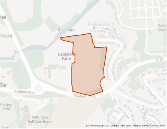
Site Size (ha) Gross: 5.42
Proposed Land Use: Housing
Minimum Development Capacity (Dwellings): 95
Site Type: Greenfield
Ward: Shipley
Settlement: Shipley
Ownership: Private
Delivery Timescale: Medium 2030-2035 (6-10)
Site Specific Requirements:
Design Principles
- Development should provide at least 95 dwellings as part of a high-quality built environment in line with Policies ST4 and DS1, at a net density of 35 dph in line with Policy HO2. This should include affordable housing (in line with Policy HO4 and an appropriate mix of dwellings (in line with Policy HO3 and having due regard relevant housing needs evidence and the character of the area).
- The site lies on the very edge of the Saltaire World Heritage Site Buffer Zone and any development proposals should carefully consider this context. Development should be sensitively integrated with the sloping topography, and should respect the remnant parkland setting of the Bankfield Hotel mansion. Mature trees on the southern boundary and perimeter drystone walls should be retained. The wooded character of the surrounding area should be considered in the design process using trees throughout the development to connect to wooded boundaries.
Site Access, Highways and Transport
- Access to the site is available via the existing access on Bradford Road, which will need improvement.
- A public right of way crosses the northern end of the site – Bingley 2 and meets with Bingley 1 at the River Aire corner.
Flooding, Water and Drainage
- Level 2 Strategic Flood Risk Assessment (SFRA): This site is required to pass part b) of the exception test5, given it is proposed for more vulnerable uses and is located within Flood Zone 3a. It must be proven that the development can be safe for its lifetime, which is 100 years for residential development. Based on the available information documented within this Level 2 SFRA, this site should be able to pass the exception test provided development is directed to the areas of the site within Flood Zone 1, including for climate change.
- There should be no development within the existing area of functional floodplain present on site. Development should be directed away from the northwestern corner of the site modelled to be at fluvial flood risk. Consultation should be had with the reservoir owners that may be affected by the development of this site. Given the historic sewer flooding in the area, developers should contact Yorkshire Water directly to check specific details at the Flood Risk Assessment (FRA) stage.
- Any FRA should be carried out in line with the latest versions of the National Planning Policy Framework; Flood Risk & Coastal Change - Planning Policy Guidance; Environment Agency online guidance; the City of Bradford District Metropolitan Council Local Plan and national and local Sustainable urban Drainage Systems, ( SuDS) policy and guidelines.
- Throughout the FRA process, consultation should be carried out with the following, where applicable, the local planning authority; the lead local flood authority; emergency planning officers; the Environment Agency; Yorkshire Water; the highways authorities; and the emergency services.
Natural and Historic Environment
- The site lies within Zone C (Recreational Pressure) - Residential development resulting in a net increase in dwellings will be required to mitigate any recreational pressure on the SPA/SAC caused by such development in accordance with the South Pennine Moors SPD and Policy NE3.
- Majority of the site is within a bat alert area. An ecological survey will be required as part of any planning application to establish the extent/impacts as well as to identify appropriate mitigation.
- Partially within identified Wildlife Habitat Network (Grassland) and adjacent to identified Wildlife Habitat Network (Wetland).
- Contains TPO woodland (1 no. group to southeast adjacent to Bradford Road). Adjacent to TPO woodland (1 no. group to east - Bankfield Farm / Mercure Hotel and 1 no. group to southwest - west of Branksome Drive). A development would need to protect and incorporate existing trees/hedgerows within site and increase the tree cover.
- The site is located within the Saltaire World Heritage Site (WHS) Buffer Zone. Development should be informed by the local context and regard should be had to the WHS Management Plan.
- A Heritage Impact Assessment (HIA) has been carried out for this site and indicates that development should be informed by its local context in terms of scale and material usage. Towards the north end of the site, mature trees are located at the north and east boundaries. These should be retained and strengthened. The Public Right of Way with its dry stone walling is aesthetically pleasing and adds to the rural character. This should be retained.
- The site has the potential to contain deposits of archaeological interest. A predetermination mitigation strategy must be agreed with WYAAS prior to any development of the site.
- The development of the Site will have no impact on any known heritage assets. There are no obtainable views of Saltaire World Heritage Site (WHS) and its Outstanding Universal Value will not be impacted upon. Subject to archaeological mitigation, the development of this site would be acceptable.
- The majority of the site is identified in the LNRS with the preferred measure T2_M01: Buffer and connect existing woodlands by creating new riparian habitats that will also support many different species, such as high-quality wooded habitats, species-rich grasslands, wetlands and pools for great-crested newts and willow tits; (at the end of Branksome drive, spur to River) preferred measure W4_M02: Create new reedbeds, wet grasslands, floodplain meadows, open standing water and wet woodland around known areas of lowland raised bog. These will attract amphibians, invertebrates and birds; (strip of land down back of houses on Branksome Drive, first stretch off Bingley Road) preferred measure B4_M02: Significantly boost biodiversity wherever possible where there are existing habitats alongside transport infrastructure; and preferred measure B2_M01: Create and maintain habitat corridors and stepping stones to connect and extend existing blue and green places. Use wetlands, such as ponds, and tree and hedgerow species to 'join the dots' through the urban fringe and into the wider countryside. Ensure new and enhanced wildlife corridors are strategic; carefully consider which species to target. Habitat corridors that work for both people and wildlife need to be wide enough to allow enough distance between people and wildlife.
Environmental Protection
- This site is located within the Clean Air Zone and development must be in accordance with the requirements set out in Policy CR1.
- Site is partially within a Mineral Safeguarding Area (MSA) for Sandstone. A mineral resource assessment will be required as part of any planning application to determine the extent and availability of any sandstone resource.
Open Space and Green / Blue Infrastructure
- Open space should be provided in line with Policy NE2, having regards to the standards set out Appendix 11. The Open Space Assessment indicates that in Shipley there is a need for increased provision of park and amenity greenspace.
- The site lies partly within the GBI Focus Area: Keighley – Bingley – Shipley Corridor, as identified in the Green and Blue Infrastructure Strategy (GBIS). The strategy should be consulted to identify opportunities for incorporating measures within the development that enhance the quality of, and connectivity to, the green and blue infrastructure network in this area.
Landscape
- LSA report – potential mitigation – Site is an area of moderate landscape sensitivity. The site lies on the very edge of the Saltaire World Heritage Site Buffer Zone and any development proposals should carefully consider this context. Development should be sensitively integrated with the sloping topography, and should respect the remnant parkland setting of the Bankfield Hotel mansion. Mature trees on the southern boundary and perimeter drystone walls should be retained. The wooded character of the surrounding area should be considered in the design process using trees throughout the development to connect to wooded boundaries. Access to the River Aire should be considered, retained and strengthened.
- Overall sensitivity rating – moderate.
- The site is within the Central Airedale Settled Floor Pasture Landscape Character area/type (G2). Consideration should be given to the guidance set out in the Landscape Character Assessment SPD.
Other constraints
- The majority of the site is classed as Grade 3b on the Agricultural Land Classification (ALC).
Green Belt (and Golden Rules)
- Site has been removed from the Green Belt. Development on the site should be consistent with the “Golden Rules” set out in the NPPF in relation to affordable housing, necessary improvements to infrastructure and accessible green space provision.
Infrastructure Requirements
- Proportionate contributions to community infrastructure will be required, where appropriate, in line with Policies ID1 and ID2, and having regard to the Local Infrastructure Plan.
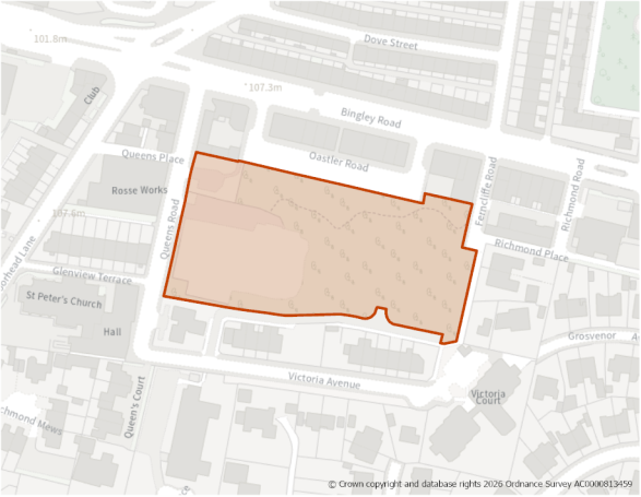
Site Size (ha) Gross: 0.93
Proposed Land Use: Housing
Minimum Development Capacity (Dwellings): 63
Site Type: Mixed
Ward: Shipley
Settlement: Shipley
Ownership: Mixed
Delivery Timescale: Medium 2030-2035 (6-10)
Site Specific Requirements:
Design Principles
- Development should provide at least 63 dwellings as part of a high-quality built environment in line with Policies ST4 and DS1, at a net density of 75 dph in line with Policy HO2. This should include affordable housing (in line with Policy HO4 and an appropriate mix of dwellings (in line with Policy HO3 and having due regard relevant housing needs evidence and the character of the area).
- The design, scale, materials, boundary treatment and landscaping need to be in keeping with sites proximity to the Saltaire World Heritage site.
Site Access, Highways and Transport
- Access to the site is available from Queens Road and Victoria Avenue which may require improvement.
Flooding, Water and Drainage
- SFRA Level 2 report - This site is not required to pass part b) of the exception test3 as it is located within Flood Zone 1, however it must still be proven that the development can be safe for its lifetime, which is 100 years for residential development. Based on current information, it should be appropriate to develop this site for more vulnerable purposes given its location in Flood Zone 1.
- Any Flood Risk Assessment must further consider the safe access and escape routes to the site.
- Given the historic sewer flooding in the area, developers should contact Yorkshire Water directly to check specific details at the Flood Risk Assessment stage.
- Any Flood Risk Assessment should be carried out in line with the latest versions of the National Planning Policy Framework; Flood Risk & Coastal Change-Planning Policy Guidance; Environment Agency guidance; the City of bradford Metropolitan District Council Local Plan and national and local Sustainable urban Drainage Systems policy and guidelines.
- Throughout the FRA process, consultation should be carried out with the following, where applicable, the local planning authority; the lead local flood authority; emergency planning officers; the Environment Agency; Yorkshire Water; the highways authorities; and the emergency services.
Natural and Historic Environment
- Contains TPO woodland (1 no. group to northwestern part of site).
- Adjacent to priority habitat (Deciduous Woodland).
- The site lies within Zone C (Recreational Pressure) - Residential development resulting in a net increase in dwellings will be required to mitigate any recreational pressure on the SPA/SAC caused by such development in accordance with the South Pennine Moors SPD and Policy NE3.
- The site is identified in the LNRS with the preferred measure B3_M01: Encourage temporary (so-called ‘meanwhile-use’, in planning terms) nature-rich uses on undeveloped smaller non-phased brownfield sites (of more than 0.25 hectares) or on land being used for larger phased developments (more than five hectares).
- The site is located within the Saltaire World Heritage Site (WHS) Buffer Zone. Development should be informed by the local context and regard should be had to the WHS Management Plan and adjacent to the Saltaire Conservation Area.
- A Heritage Impact Assessment (HIA) has been carried out for this site and indicates that the site lies at a slightly lower level than Queens Road, and this topography could be utilised to reduce the apparent height of new buildings. A bank of well-established trees along the northern boundary also provides an opportunity for screening. The retention of these trees will be important in minimising visual impacts on views into and out of the WHS, as well as on the setting of the Conservation Area and nearby listed buildings. Development should generally be limited to a low height (typically no more than 2–2.5 storeys) to avoid interrupting key views.
- St Peter’s Church on Moorhead Lane is a prominent landmark (and identified as a non-designated heritage asset), and its visual prominence within the area should be preserved. Any new development should remain clearly subservient to the church, with building heights kept below the ridge height of its main structure.
- Careful consideration must be given to the scale and massing of buildings, as well as the choice of materials, to ensure that development responds appropriately to the established character and context of the surrounding area.
- Development proposals should be informed by the local context, including existing tree-lined boundaries, which contribute positively to the character of the street scene. Retention of these features is encouraged. Any development should avoid appearing overly prominent, particularly given the site’s role as part immediate setting of the WHS.
- If development accords with the measures outlined above, it is likely that the site could accommodate development across much of its area while resulting in negligible harm to the setting of listed buildings. With carefully designed mitigation, any residual impact is likely to fall within the category of less than substantial harm (of an acceptable level).
- Development may be acceptable with appropriate measures and mitigation to protect the setting of the nearby heritage assets.
- Partly within 50m buffer of Listed Buildings (Grade II 49-61 & 65-97 Bingley Road; 61-63 Gordon Terrace).
- Adjacent to site of archaeological potential (Class 1).
Landscape
- The site is partly within the Central Airedale Settled Floor Pasture Landscape Character area/type (G2). The site is within the settlement and no landscape sensitivity assessment was undertaken for this site. Consideration should be given to the guidance set out in the Landscape Character Assessment SPD.
Environmental Protection
- This site is located within the Clean Air Zone and development must be in accordance with the requirements set out in Policy CR1.
- The site was historically used as a mineshaft, quarry , giving rise for potential land contamination. A Land Contamination Assessment – Phase 1 Report will be required as part of any planning application. Impacts should be addressed in line with Policy CR2.
- Site lies partly within 150m buffer of a former landfill site. A Land Contamination Assessment – Phase 1 Report will be required as part of any planning application.
- Site is partially within a Development High Risk Area for coal mining, indicating that it contains one or more recorded former related features at surface or shallow depth. A Coal Mining Risk Assessment (CMRA) will be required as part of any planning application.
- Site is within a Mineral Safeguarding Area (MSA) for Sandstone. A mineral resource assessment will be required as part of any planning application to determine the extent and availability of any sandstone resource.
Other constraints
- Barden aqueduct passess under the site so will need to consult with Yorkshire Water.
Open Space and Green / Blue Infrastructure
- Open space should be provided in line with Policy NE2, having regards to the standards set out Appendix 11. The Open Space Assessment indicates that in Shipley there is a need for increased provision of park and amenity greenspace.
- The site lies within the GBI Focus Area: Keighley – Bingley – Shipley Corridor, as identified in the Green and Blue Infrastructure Strategy (GBIS). The strategy should be consulted to identify opportunities for incorporating measures within the development that enhance the quality of, and connectivity to, the green and blue infrastructure network in this area.
Infrastructure Requirements
- Proportionate contributions to community infrastructure will be required, where appropriate, in line with Policies ID1 and ID2, and having regard to the Local Infrastructure Plan.
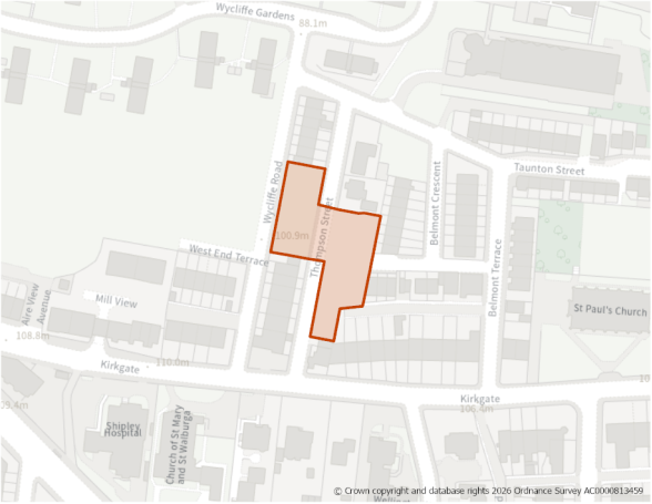
Site Size (ha) Gross: 0.22
Proposed Land Use: Housing
Minimum Development Capacity (Dwellings): 11
Site Type: Greenfield
Ward: Shipley
Settlement: Shipley
Ownership: Other
Delivery Timescale: Long 2035+ (11+)
Site Specific Requirements:
Design Principles
- Development should provide at least 11 dwellings as part of a high-quality built environment in line with Policies ST4 and DS1, at a net density of 50 dph in line with Policy HO2. This should include affordable housing (in line with Policy HO4 and an appropriate mix of dwellings (in line with Policy HO3 and having due regard relevant housing needs evidence and the character of the area).
- Sensitive design should be applied to the development layout to respect the setting of the World Heritage Site, e.g. by imitating the development pattern of Victorian terraces within the local context.
- It is important to retain the existing mature trees on the site boundary to partially screen views from the existing residencies and to soften any new development edge. For development to blend easily with the surrounding urban fabric when viewed from the sensitive visual receptors associated with the World Heritage Site, it must be constructed of similar materials to the local vernacular: light sandstone or gritstone with slate roofs.
Site Access, Highways and Transport
- Site access can be take from Wycliffe Road or Thompson Street.
Natural and Historic Environment
- The site lies within Zone C (Recreational Pressure) - Residential development resulting in a net increase in dwellings will be required to mitigate any recreational pressure on the SPA/SAC caused by such development in accordance with the South Pennine Moors SPD and Policy NE3.
- TPO Woodland and 15m buffer down western site boundary must be retained and protected. The design and layout of any development should ensure these trees are preserved and enhanced in line with Policy NE6. An arboricutural study should be provided as part of any planning application.
- The site is located within the Saltaire World Heritage Site (WHS) Buffer Zone. Development should be informed by the local context and regard should be had to the WHS Management Plan.
- The site lies with the Keighley – Bingley – Shipley opportunity area, as identified in the Green and Blue Infrastructure Strategy (GBIS). The strategy should be consulted to identify opportunities for incorporating measures within the development that enhances the quality of, and connectivity to the green and blue infrastructure network, in line with Policies ST6 and NE1.
- In Heritage Impact Assessment (HIA) undertaken for rejected site H1057 states that this site would not directly impact on the World Heritage site.
Landscape
- The site is partly within the Central Airedale Settled Floor Pasture Landscape Character area/type (G2). Consideration should be given to the guidance set out in the Landscape Character Assessment SPD.
- It is important to retain the existing mature trees on the site boundary to partially screen views from the existing residencies and to soften any new development edge. For development to blend easily with the surrounding urban fabric when viewed from the sensitive visual receptors associated with the World Heritage Site, it must be constructed of similar materials to the local vernacular: light sandstone or gritstone with slate roofs. Sensitive design should be applied to the development layout to respect the setting of the World Heritage Site, e.g. by imitating the development pattern of Victorian terraces within the local context.
Environmental Protection
- Site within 150m buffer of a former landfill site. A Land Contamination Assessment – Phase 1 Report will be required as part of any planning application.
- Site located within Sandstone Safeguarding Area. A mineral resource assessment will be required as part of any planning application to determine the extent and availability of any Sandstone resource.
Open Space and Green / Blue Infrastructure
- Open space should be provided in line with Policy NE2, having regards to the standards set out Appendix 11. The Open Space Assessment indicates that in Shipley there is a need for increased provision of park and amenity greenspace.
- The site lies within the GBI Focus Area: Keighley – Bingley – Shipley Corridor, as identified in the Green and Blue Infrastructure Strategy (GBIS). The strategy should be consulted to identify opportunities for incorporating measures within the development that enhance the quality of, and connectivity to, the green and blue infrastructure network in this area.
Infrastructure Requirements
- Proportionate contributions to community infrastructure will be required, where appropriate, in line with Policies ID1 and ID2, and having regard to the Local Infrastructure Plan.
E159: Crag Road Comment
Site Boundary:
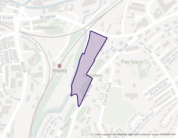
Site Size (ha) Gross: 4.95
Net Developable Area (ha): 1.24
Proposed Land Use: Employment (Eg(i), B2 and B8)
Site Type: Greenfield
Ward: Windhill and Wrose
Settlement: Shipley
Ownership: Mixed
Delivery Timescale: 2035-2040
Site Specific Requirements: Flooding, Water and Drainage
- Risk of surface water flooding.
Natural and Historic Environment
- The site lies within Zone C (Recreational Pressure) - Residential development resulting in a net increase in dwellings will be required to mitigate any recreational pressure on the SPA/SAC caused by such development in accordance with the South Pennine Moors SPD and Policy NE3.
- Site is partially within an identified Wildlife Habitat Network (Wetland, Woodland and Grassland) and within a bat alert area with two bat roosts on site. Ecology survey may be required at the planning application stage. Early engagement with the Council's Biodiversity Officer is recommended.
- Part of the site is a TPO Woodland.
- The site is identified in the LNRS with the preferred measure B3_M03: Enhance the boundaries of brownfield sites.
- Site is within the World Heritage Site Buffer zone and on a key prominent gateway to the WHS.
Environmental Protection
- This site is located within the Clean Air Zone and development must be in accordance with the requirements set out in Policy CR1.
- Site is adjacent to a former landfill, which may pose contamination issues.
- Within 200m of operational/permitted waste management site [NB two sites]
- Site is within a Mineral Safeguarding Area (MSA) for sandstone. A mineral resource assessment will be required as part of any planning application to determine the extent and availability of any sandstone resource.
- Site is crossed by a high-pressure gas pipeline (owned/operated by National Gas or Northern Gas Networks). Design and layout of any development should ensure that appropriate clearances are taken into consideration. Consultation should take place with the Health and Safety Executive, National Gas and Northern Gas Networks, as appropriate.
- The site is adjacent to an electricity transmission line. Development should include a strategy for responding to the National Grid Overhead Cable Route present within the site which demonstrates how the National Grid Design Guide and Principles have been as part of the design and layout and how the impact of the assets has been reduced through good design.
Open Space and Green / Blue Infrastructure
- The site lies within the Keighley- Bingley – Shipley CorridorOpportunity Area, as identified in the Green and Blue Infrastructure Strategy (GBIS). The strategy should be consulted to identify opportunities for incorporating measures within the development that enhance the quality of, and connectivity to, the green and blue infrastructure network in this area.
- Site is partially within an area of medium provision and high need for green and blue infrastructure. Development proposals should focus on carefully designed green and blue infrastructure to contribute towards site specific issues e.g. flood mitigation, urban cooling etc.
- Where appropriate, the site should seek to provide on-site open space in line with Policy NE2.
Infrastructure Requirements
- Proportionate contributions to community infrastructure will be required, where appropriate, in line with Policies ID1 and ID2, and having regard to the Local Infrastructure Plan.
