

Bradford District Local Plan - Publication Draft (Regulation 19) (October 2026)
Section 5: Settlement Policies & Site Allocations for Regional City
Policy BCC1: Bradford City Centre
Reshaping the City Centre
A City of Many Cultures
Bradford is a multi-cultural city which is proud of its history, heritage and diversity. Its cultural ambitions lie in recognising creativity and opportunities, thinking big and having fun, living better lives and making the most of what we have and are as people. The city and its communities face significant economic, deprivation and physical challenges but a vibrant, healthy, distinctive and prosperous City Centre is good for all and a cornerstone of the local plan and spatial strategy.
An Inspirational Place to Live
Bradford city is growing into a more vibrant, liveable and greener city with City Village changing the perception of city centre living through a new sustainable and community-friendly centre neighbourhood. Sensitive housing-led regeneration is at the heart of the vision, creating more new neighbourhoods but also providing opportunities for businesses to invest and prosper, boosted by a growing local population. High-quality housing catering for a diverse range of needs together with safer streets, community amenities, public spaces, green spaces, parks and places for recreational with easy travel connectivity all form part of the ambition.
An Entrepreneurial City
Bradford has been identified as one of the best places in Britain to start a business and one of the top 20 cities for business growth. As the youngest city in the UK, with 28% of the population aged under 20 years, the current and future labour market has significant potential to support economic growth and enterprise. Bradford District is home to a number of large headquarters, including Morrisons, Hallmark cards, Vanquis and Yorkshire Building Society, and has over 16,600 businesses employing 250,000 people across the UK with a combined turnover of over £35bn; its city economy is the 10th largest in England. The strategy and policy for the regional city and city centre in particular aims to place Bradford at the centre of investing in proven economic strengths but also backing fast growth and opportunity sectors.
A City Futureproofing for Growth - Supporting Talent, Skills and Learning
Bradford is fortunate through the University of Bradford and Bradford College to have leading edge education facilities within the heart of the city’s knowledge quarter regeneration area (RA) and bordering Thornton Road RA, which are not only central to the growth of local learning, training and skills but invest directly in the city and help support a vibrant student population and related economy. With a local culture of enterprise and innovation, education providers play a critical role in increasing Bradford’s attractiveness in priority sectors, linking students to growth sectors but also help directly tackle technical construction skills gaps.
A City with an Integrated Transport Vision
Investment in a modern, efficient city transport system with fast and reliable connections is being prioritised. A new city centre rail station and transit network with integrated bus infrastructure and continued focus on active travel are at the forefront of shaping the city’s future and acting as major catalysts for growth, place-making and area regeneration. The focus is on creating a more resilient and higher-capacity public transport network for future growth, where seamless connections between services and modes make complex journeys easier. The expanding traffic-free central precinct is a fertile ground for growing active travel journey options throughout the city. There will be a focus on creating new traffic-free areas, such as City Village, with an emphasis on expanding these as new blocks of development materialise. New and busier transport nodes will shape a wider range of safe and integrated low carbon travel options which link communities, homes and businesses.
Delivering a Regeneration Pipeline
It is recognised that Southern Gateway - as the location for a potential new railway station - is one of the country’s largest regeneration areas (126 ha) providing a once in a generation opportunity to drive Bradford city’s economic, housing and physical transformation. The scale of city centre growth and development opportunities across its other eight city centre regeneration areas is very substantial – a current pipeline of 22ha of commitments and allocations and the areas themselves cover a geography of 217ha. The reshaped, better connected city centre will deliver 10,000 new homes, new economic growth and physical transformation.
Settlement Hierarchy
The Local Plan settlement hierarchy identifies the city centre within the Regional City of Bradford as the prime focus for housing, employment, shopping, leisure, education, health and cultural activities and facilities in the District. Whilst the City Centre has historically performed this function, Bradford is reshaping its city centre, transforming its economic, environmental, physical and social conditions to support its long-term regeneration.
Built Different Bradford 2025-2035 Regeneration & Growth Plan provides a strong strategic direction for the City Centre that needs to be supported and delivered through the Local Plan.
Built Different Bradford 2025 -2035 Regeneration & Growth Plan
Major projects are driving that change. City Village is bringing new homes into a walkable, mixed neighbourhood close to the heart of the centre. Southern Gateway, one of the region’s largest regeneration sites, will unlock space for housing, jobs, culture, and new activity at scale.
That shift is already visible. Darley Street Market is busy with traders, food, and events. Bradford Live has opened as a major live venue, attracting audiences from across the country. Norfolk Gardens has been renewed as a central public space, while established anchors like The Broadway, St George’s Hall, and the National Science and Media Museum continue to draw people into the city centre and keep it active throughout the day and evening.
POLICY BCC1 BRADFORD CITY CENTRE Comment
Settlement Plan
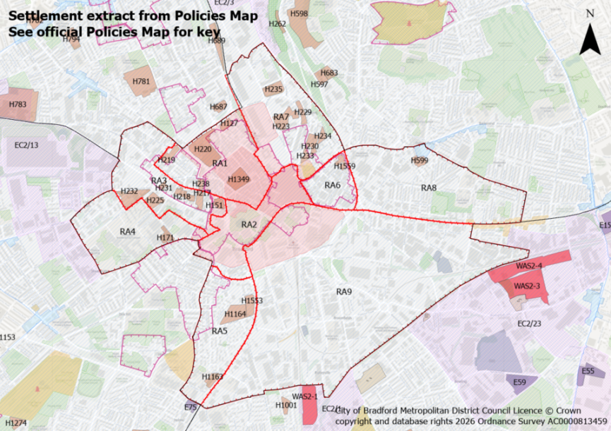
Settlement Hierarchy and Spatial Directions
- Bradford City Centre is defined on the policies map and consists of the immediate city centre core and wider boundary.
- Deliver a holistic vision for the future of the city as a culturally diverse, liveable and vibrant centre which maximises opportunities for improved connectivity, place-making and support for new homes, jobs, business growth and local services and facilities.
- The City Centre will be reshaped through a series of transformational major infrastructure projects and focused regeneration opportunities over the plan period to deliver growth through Culture, Transport, Skills and a Regeneration Pipeline.
- Place-led housing delivery which meets a diverse range of housing and accommodation needs through:
- Housing that is responsive to market demands for high density city living and apartments with supporting infrastructure.
- Provision of a range of family housing which is adaptable to changing needs and can be integrated effectively into city and urban forms.
- Support for senior housing and specialist accommodation which is centrally located and benefits from connectivity to local services and facilities.
- A widened range of housing products, including co-living, Build To Rent which may support students, graduates and young professionals seeking flexible city centre living with supporting facilities.
- A diversity in the range of tenure and housing types to support the creation of distinctive city neighbourhoods.
- Repurposing vacant heritage assets and under-utilised spaces for small schemes and infill developments supporting housing diversity.
- Avoiding an over concentration of single housing types and HMO facilities.
- Support economic growth of existing and new businesses through:
- Improving city footfall and business opportunities via an increased residential and workforce population and improved transportation connectivity.
- Maintaining a vibrant and healthy street scene with the continued protection and diversification of ground floor commercial premises - avoiding the proliferation of unhealthy food and retail environments.
- Creating the right city centre trading environment to retain and attract indigenous businesses to expand and diversify.
- A city centre which can readily attract and accommodate at pace expanding economic sectors including digital, creative industries and professional and financial services.
- Prime city centre business investment space within close proximity to new transport infrastructure and hubs.
- Space for business innovation and flexible workspaces to support entrepreneurs and micro businesses.
- A city that is attractive to all and safe with welcoming public spaces designed to support public life.
- A vibrant visitor and evening economy with night-time activities including food and cultural facilities events.
- Retaining institutional organisations and investors with a long-term stake in the future of the city.
- Maintaining a vibrant mix of cultural facilities, visitor attractions and hotels and accommodation to grow Bradford’s visitor economy
- Encouraging education-led regeneration in parts of the city by supporting new and existing opportunities focused on Bradford University, the College, the proposed Performing Arts School/Specialist Creative College in 2028 and other skills and learning facilities.
- Bradford City Centre is made up of nine Regeneration Areas (RA1 – Westgate, RA2 - Commercial and Leisure District, RA3 - Thornton Rd, RA4 - Knowledge Quarter, RA5 - Manchester Rd, RA6 - Little Germany, RA7 - Forster Square, RA8 - Leeds Rd and RA9 - Southern Gateway) that define the strategic growth opportunity for the city to create sustainable urban communities over the plan period and beyond.
- Development proposals in the city centre will support the following transformational major projects by:
- Southern Gateway – facilitating delivery of over 5,000 new homes, employment land and high-quality public realm (RA9)
- Bradford Rail Programme - Make provision for the delivery of new a railway station and future upgrades and associated infrastructure
- Mass Transit – Make provision for the delivery of a mass transit network and associated infrastructure into the city centre
- City Village – facilitating the delivery of the initial and future phases of the inner-city housing growth project
Meeting Growth Needs
- Housing development in the City Centre will deliver approximately 10,332 dwellings through a combination of sites under construction, planning permissions and new site allocations during the plan period together with additional supply across the 9 defined regeneration areas listed in 11 below, as set out in Table BCC1.1
- Table BCC1.1 - City Centre Housing Development
|
Under Construction |
Planning Permission |
Site Allocations |
Regen Areas |
|
|
Totals |
481 |
764 |
3,837 |
5,250 |
- Deliver housing site allocations as shown on the policies map and within the proformas in section 5 and support additional small sites including the redevelopment of buildings for new homes across the regeneration areas set out below:
- RA1: Westgate (29ha) - infill development of circa 500 homes through the re-use of underutilised land, changes of use and conversion of vacant buildings and the further renewal of the city’s traditional retail and leisure core and parades
- RA2: Commercial and Leisure District (21.5ha) – enhancement of the cultural and commercial heart of the city with its connected city park, civic and office buildings and modern retail and entertainment core. This will include support for a greater diversity of uses and small-scale residential infill and conversions of circa 150 homes.
- RA3: Thornton Road (25.5ha) - positioned between Westgate and the Knowledge Quarter, this prominent western gateway offers significant regeneration potential through retrofitting heritage buildings and transforming small vacant sites into an additional 250 homes, which will be delivered together with commercial needs and public realm interventions to the streetscape to improve the liveability of the area.
- RA4: Knowledge Quarter (25ha) - continued transformation for knowledge based-uses, cultural, research and creative uses with diversification and intensification of small sites into 100 residential uses compatible with existing facilities including Build to Rent, student and graduate accommodation and private rental.
- RA5: Manchester Road (25ha) - the delivery of high density housing at key gateway points along a rapid bus transport corridor into the city, together with support for new small developments of circa 100 homes whilst improving the physical environment and connectivity.
- RA6: Little Germany (9ha) - protection and respect for the heritage of this important historic merchant quarter while enhancing its focus as a distinctive visitor destination with small scale offices, studios, workshops, co-working creative live/workspace, and sensitive residential conversions and infill developments of circa 250 homes.
- RA7: Forster Square (38ha) - unlocking development potential at scale through a reimagined transport and economic hub with a new high density residential neighbourhood set within a green and blue urban park environment acting as a catalyst for further investment and additional small site developments totally approximately 650 homes.
- RA8: Leeds Road(44ha) – promotion of this key inter city transport corridor and support for opportunities for its continued physical transformation, providing space for retail, commercial, business and residential uses of circa 250 homes with improved public transport integration.
- RA9: Southern Gateway (126ha) - one of the largest regeneration sites in the country underpinned by a comprehensive masterplan / design framework this transformational project has potential to change Bradford for generations, through the development and delivery of an entirely new district of the city. Its transformation will include new rail infrastructure and high-quality high density office, commercial, residential developments of circa 3000 homes in the plan period, new public and green spaces interwoven with the wider built environment to create a sustainable and future-proof district that will transform the experience and perception of living and doing business in Bradford.
Local Services and Facilities
- Provisions for retail, leisure, office and other main town centre uses, including cultural and creative offer, visitor and evening economy will be supported to enhance the vitality and viability of the city centre as the principal retail, cultural and leisure destination for residents. Proposals which contribute to the growth and regeneration of the city centre as an inclusive, adaptable and economically resilient area will be supported provided there is no unacceptable adverse impact on living conditions.
- Existing open spaces, and green and blue infrastructure, will be protected and enhanced to support the delivery of the opportunities identified in the GBI Focus Area A (Bradford Inner City)[1] and play a key role shaping the city centre over the plan period. New developments will provide accessible multifunctional open space for existing and new communities within the city centre. These should help to create a network of green corridors to connect habitats and improve ecology both within the city centre and wider corridors.
- Support the integration of district sports hubs into the ground floors of former mill and other historic buildings within the city to create active ground floor uses, supporting the wider reuse of the buildings and sports and leisure led active regeneration within the city.
City Design and Environment
- Development proposals within the City Centre should respond positively to their context and contribute to creating a series of distinctive places in support of delivering the vision and the Regeneration Areas outlined above. Transformational projects provide an opportunity to reimagine parts of the centre with high-quality contemporary design whilst also reflecting Bradford’s unique identity, be that its industrial heritage, high-quality landscapes or cultural influences, and taking positive cues from the surrounding built environment. Greater building heights may be appropriate in some locations, subject to relevant design policies (including Policy DS3), while other areas may require a more sensitive approach to infill development and retrofit.
- Development should also contribute to creating a more liveable, vibrant and connected city centre, with buildings that animate the public realm and new spaces that support cultural life. In areas where heritage assets and historic townscape features are present, including listed buildings and the four city centre conservation areas, development should respect and sensitively respond to these qualities, supporting their retention, repair and enhancement, and bring vacant buildings and upper floors back into use. Proposals should also, where appropriate, seek to establish strategic green corridors and rediscover natural watercourses as a positive focus for active routes and placemaking, to help link the heart of the city centre to surrounding urban neighbourhoods and green landscapes.
- The following design codes will apply to development in the city centre:
- Permeability – new streets should connect at both ends to other streets and not create cul-de-sacs for pedestrians.
- New urban blocks – these should be kept small (e.g. no more than 120m on their longest dimension) to support walkability in the city centre.
- Corners – prominent buildings should be designed as landmarks, reflecting Bradford’s tradition of strong corner buildings.
- Active frontages – new buildings should face onto and animate the public realm providing visual interest at ground floor level with entrances and glazing, especially on high streets and secondary streets and onto public open spaces.
- Boundary treatments – normally the building line should define the edge of the public realm within the city centre. Where this is impractical then well-designed, bespoke treatments to distinguish public and private spaces will be required which could be based on Bradford’s heritage or culture or be landscape-led supporting urban greening.
- Materials – materials should be used that are durable to the Bradford climate, appropriate to the positive character of the city centre and high quality in terms of aesthetics and performance.
- Historic fabric – within historic areas the focus should be on responding to the form and identity of existing buildings – including building lines, the variety in massing, rooflines and building heights, and the often ‘tripartite’ structure of buildings (base, middle and top) and vertical emphasis of fenestration.
- Commercial plot ratios – low density commercial buildings are not acceptable in the city centre. Proposals should achieve a plot ratio of at least 2:1 (meaning the total floor area of the building is twice the site area) to make effective use of land.
- Parking/space for vehicles – using large parts of sites for surface car parking and/or circulation space for vehicles is not acceptable in the city centre.
- Public realm – developments should take opportunities to improve or introduce new areas of public realm supporting and expanding the recent transformative works to make the city centre more pedestrian focused, healthy, climate resilient and biodiverse.
- Cultural activation – strategic major development proposals (500+ homes or equivalent) in the City Centre should provide new high-quality civic space which is designed to enable the cultural activation of the public realm for events, gatherings etc through appropriate layout, design, materials and infrastructure provision.
- City Centre developments should maintain and improve air quality to protect human health, wellbeing and the environment, within the Clean Air Zone more stringent measures apply to major developments. (Policy CR1)
- Major development proposals in the city centre that are prominent or sensitive due to their scale and/or location or which include tall buildings should include computer generated visualisations to illustrate the likely visual impact of the development and show it in a real-world context using 3D digital modelling. The Council with University of Bradford has produced a 3D digital twin of the city centre and Southern Gateway which is available for this purpose. Policy DS3 provides further detail on requirements for tall buildings.
Infrastructure
- The implementation of the West Yorkshire Local Transport Plan and the Bradford District Transport Strategy will secure a high-quality public transport network for the city, along with a comprehensive and attractive network for walking, wheeling and cycling, to improve the environment for residents, businesses and visitors.
- New and improved rail capacity and connectivity through the Bradford Rail Programme will increase the use of both central Bradford stations at Forster Square and Interchange, and these station footprints are expected to evolve to meet these new needs, and that of interchange with other modes.
- Mass Transit, expected to principally take the form of a street-running tram, will irrigate the city centre more finely than heavy rail, and provide local opportunities for growth and densification where it’s stops are located. Mass Transit will serve both city centre stations and play a role in linking these together, as well as connecting the city centre fringe and beyond more efficiently than other options.
- The bus network, under public control, will be re-shaped to best meet the evolving transport needs of the district and respond to the expansion of the rail and Mass Transit networks, as well as improved in efficiency and speed in its own right. It is expected to command a continued footprint in the city centre, with its infrastructure comprising (a) the City Centre Bus Loop, (b) the bus hubs for interchange along this Loop and (c) one or more terminal facilities meeting the requirements of bus and coach operators.
- Active travel is the foundation of everyday activity in the city centre, where the Traffic-free Central Precinct allows for cycling, wheeling and journeys on foot to be made in safety. Facilities for active travel will be expanded in other areas of the city centre, including safer junctions, quieter streets and separated active travel facilities, with future plans set out in the Local Cycling and Walking Infrastructure Plan (LCWIP). Where there is an interaction with motor traffic, cycle infrastructure provision will be in line with the guidance in LTN 1/20.
- City Centre parking options will provide well-located facilities, meeting the needs of those owning and renting cars, bicycles and other forms of vehicles, suitable for both short and long stays. Facilities for larger vehicles will be located principally off-street and parking will be charged for in line with applicable policy.
- As part of the regeneration ambitions of the city centre, key projects will need to take a joint, comprehensive and holistic approach to considering the flood risk issues from the Bradford Beck and look at the potential to develop city-wide mitigation measures, which will offer wider public benefits. The redevelopment or conversion of existing buildings in the city centre will be supported where they accord to Policy CR4.
- Contributions towards improvements in community infrastructure, including consideration of additional education, healthcare and recreation provision as a result of an increased residential population.
- New build development and major transformational projects should support and where possible connect to available city centre energy networks or be 'connection ready' to take advantage of any future phases of the existing network or new networks. This will support the opportunities for existing buildings to utilise both the existing and future phases of the network through market delivery. (Policy CR3)
Evidence and Studies
- Built Different Bradford 2025-2035 Regeneration and Growth Plan (2026)
- Bradford Green and Blue Infrastructure Strategy (2026)
- Bradford Local Cycling and Walking Infrastructure Plan
- City Of Bradford Development Framework (2024)
- Local Infrastructure Plan (2026)
- Retail and Leisure Study (2026)
- Settlement Study (2026)
- Sports Assessment (2026)
- Transport Assessment (2026)
- West Yorkshire Local Growth Plan (2025–2035)
- West Yorkshire Local Transport Plan (2025)
Bradford City Centre: Site Allocations
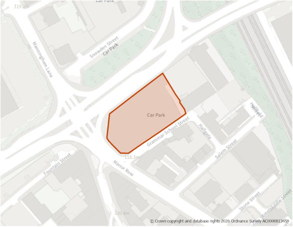
Site Size (ha) Gross: 0.39
Proposed Land Use: Housing
Minimum Development Capacity (Dwellings): 105
Site Type: PDL
Ward: City
Settlement: City Centre
Ownership: Private
Delivery Timescale: Long 2035+ (11+)
Site Specific Requirements
Design Principles
- The site is most suitable for apartment development. This should be well designed in line with Policies DS1 and DS3 and should respond to the sloping nature of the site.
- The development should deliver at least 105 units at a net density of 300dph in line with Policy HO2. New trees should be planted on the northern site boundary
Site Access, Highways and Transport
- Site access should be taken from Grammar School Street
Flooding, Water and Drainage
- Site contains potential for surface water flooding, likely to be from accumulation from hard surfaced areas. Surface water levels post development should be 30% less than pre-development and may require some form of SuDs to absorb water away from buildings. Proposals will need to be discussed and agreed with the Local Lead Flood Authority (City of Bradford MDC) and the Environment Agency at the planning application stage.
Natural and Historic Environment
- The site adjoins the City Centre conservation area. The development of the site should mitigate against any perceived negative impacts on heritage through its design.
Environmental Protection
- Site lies within the Clean Air Zone and adjacent to a road where noise and traffic pollution levels are of concern. Tree planting will mitigate against negative impacts.
- The site is within a mineral safeguarding area (coal minerals).
Open Space and Green / Blue Infrastructure
- The site lies within the Bradford City Centre Opportunity Area, as identified in the Green and Blue Infrastructure Strategy (GBIS). The strategy should be consulted to identify opportunities for incorporating measures within the development that enhance the quality of, and connectivity to, the green and blue infrastructure network in this area.
Infrastructure Requirements
- Proportionate contributions to community infrastructure will be required, where appropriate, in line with Policies ID1 and ID2, and having regard to the Local Infrastructure Plan.
H151: Sunwin House, Godwin Street, City Centre Comment
Site Boundary
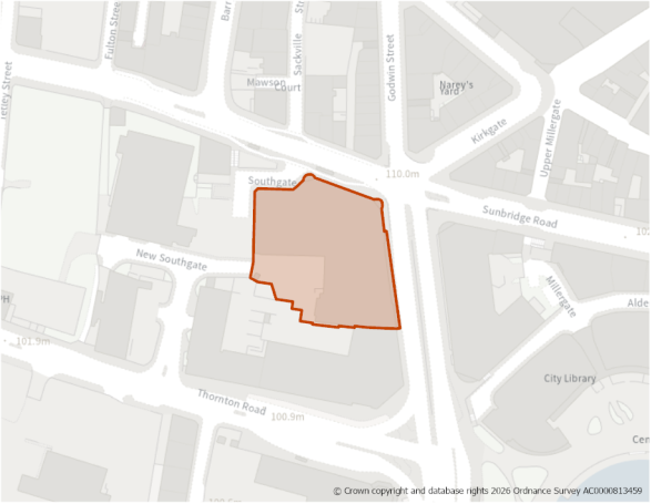
Site Size (ha) Gross: 0.39
Proposed Land Use: Housing
Minimum Development Capacity(Dwellings): 118
Site Type: PDL
Ward: Manningham
Settlement: City Centre
Ownership: Private
Delivery Timescale: Medium 2030-2035 (6-10)
Site Specific Requirements
Design Principles
- The site offers the opportinity for the redevelopment of the former Grade II listed department store building into apartments. It should deliver at least 118 homes at 300 dph net density in line with Policy HO2.
Site Access, Highways and Transport
- The building sits in the heart of the City Centre. The redevelopment for resdential development offers the potential for car free layout.
Natural and Historic Environment
- Site is within a bat alert area. An Ecology survey may be required at the planning application stage. Early engagement with the Council's Biodiversity Officer is recommended.
- The building is Grade II listed and lies in the City Centre Conservation Area. The development of the site should mitigate against any perceived negative impacts on heritage through its design.
- The site is located within a bat alert area. An ecological survey will be required as part of any planning application to establish the extent/impacts as well as to identify appropriate mitigation.
Environmental Protection
- Site lies within the Clean Air Zone and adjacent to a road where pollution levels are of concern. Developer should seek to provide landscape buffer to the western site boundary to mitigate against impacts.
Open Space and Green / Blue Infrastructure
- The site lies within the Bradford City Centre Opportunity Area, as identified in the Green and Blue Infrastructure Strategy (GBIS). The strategy should be consulted to identify opportunities for incorporating measures within the development that enhance the quality of, and connectivity to, the green and blue infrastructure network in this area.
Infrastructure Requirements
- Proportionate contributions to community infrastructure will be required, where appropriate, in line with Policies ID1 and ID2, and having regard to the Local Infrastructure Plan.
H171: Buildings at Bradford College, Great Horton Road, City Centre Comment
Site Boundary
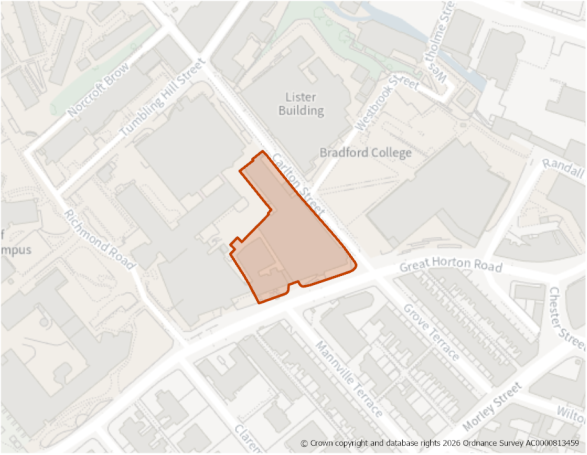
Site Size (ha) Gross: 0.58
Proposed Land Use: Housing
Minimum Development Capacity (Dwellings): 190
Site Type: PDL
Ward: City
Settlement: City Centre
Ownership: Private
Delivery Timescale: Short 2025-2030 (1-5)
Site Specific Requirements
Design Principles
- The site should be redeveloped sensitively retaining all buildings which are Grade II listed. Planning permission was granted in 2021 for 190 apartments but there is no indication that development has started.
Site Access, Highways and Transport
- Site access from Great Horton Road.
Natural and Historic Environment
- Grade II listed buildings. A heritage impact assessment will be required as part of the planning application. The development of the site should mitigate against any perceived negative impacts on heritage through its design.
- The site is located within a bat alert area. An ecological survey will be required as part of any planning application to establish the extent/impacts as well as to identify appropriate mitigation.
Environmental Protection
- Within clean air zone and adjacent to a road where pollution levels are of concern. Complimentary landscaping will need to be provided where possible to help miitgate against the impacts of air pollution.
Open Space and Green / Blue Infrastructure
- The site lies within the Bradford City Centre Opportunity Area, as identified in the Green and Blue Infrastructure Strategy (GBIS). The strategy should be consulted to identify opportunities for incorporating measures within the development that enhance the quality of, and connectivity to, the green and blue infrastructure network in this area.
Infrastructure Requirements
- Proportionate contributions to community infrastructure will be required, where appropriate, in line with Policies ID1 and ID2, and having regard to the Local Infrastructure Plan.
Planning Permission
- Planning approval was granted in 2021 for the redevelopment of the buildings to 190 apartments- 20/01221/MAF (granted 27/4/2021).
H217: Tetley Street/Sunbridge Road, City Centre Comment
Site Boundary
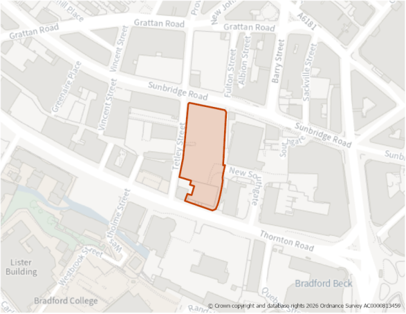
Site Size (ha) Gross: 0.50
Proposed Land Use: Housing
Minimum Development Capacity (Dwellings): 135
Site Type: PDL
Ward: Manningham
Settlement: City Centre
Ownership: Private
Delivery Timescale: Medium 2030–2035 (6–10)
Site Specific Requirements
Design Principles
- The development of the site should be carefully designed in accordance with Policies DS1 and DS3 to enhance the area and mitigate against the harmful effects of this derelict site. New buildings should respond to the topography and character of the area with a building which steps up the hillside and be of a scale similar to other buildings in this part of the city. The corners of the building and frontage to Thornton Road should be carefully considered with an active frontage to improve the public realm and the pedestrian environment.The development should deliver at least 135 apartments at a net density of 300 dph in line with Policy HO2.
Site Access, Highways and Transport
- Site access should be taken from Tetley Street.
Flooding, Water and Drainage
- A small part of the site is affected by flood zone 2 which crosses Thornton Road from the Bradford Beck. Developer will be required to submit a flood risk assessment and proposals will need to be discussed and agreed with the Local Lead Flood Authority (City of Bradford MDC) and the Environment Agency at the planning application stage.
Natural and Historic Environment
- Site is within a bat alert area. An Ecology survey may be required at the planning application stage. Early engagement with the Council's Biodiversity Officer is recommended.
- The site falls within the Goitside Conservation area and a Grade II listed building is located within 50m of the north west corner. The design of the site should respond positively to the surrounding historic context and safeguard the character and setting of the listed building.
Environmental Protection
- Within Clean Air Zone.
- The former use of the site as a woollen mill may require investigation regarding contamination.
Open Space and Green / Blue Infrastructure
- The site lies within the Bradford City Centre Opportunity Area, as identified in the Green and Blue Infrastructure Strategy (GBIS). The strategy should be consulted to identify opportunities for incorporating measures within the development that enhance the quality of, and connectivity to, the green and blue infrastructure network in this area.
Infrastructure Requirements
- Proportionate contributions to community infrastructure will be required, where appropriate, in line with Policies ID1 and ID2, and having regard to the Local Infrastructure Plan.
H218: Land and buildings south of Sunbridge Road, City Centre Comment
Site Boundary
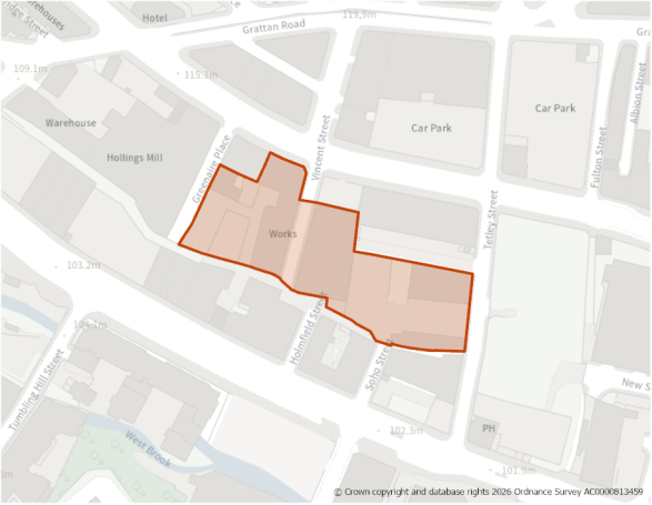
Site Size (ha) Gross: 0.57
Proposed Land Use: Housing
Minimum Development Capacity (Dwellings): 77
Site Type: PDL
Ward: Manningham
Settlement: City Centre
Ownership: Private
Delivery Timescale: Long 2035+ (11+)
Site Specific Requirements
Design Principles
- Site comprises underused buildings and associated land within a conservation area. The site should be developed for at least 77 dweliings at 150dph net density in line with Policy HO2 and should retain the existing mill buildings where possible which should be converted in a sensitive manner to ensure that any harm is minimised with appropriate mitigation.
Site Access, Highways and Transport
- Site access can be taken from the surrounding road network.
Natural and Historic Environment
- Site is within a bat alert area. An Ecology survey may be required at the planning application stage. Early engagement with the Council's Biodiversity Officer is recommended.
- The site falls within the Goitside Conservation area and is within 50m of a number of Grade II listed buildings including Colonial Building and SOHO Mills. The development of the site should mitigate against any perceived negative impacts on heritage through its design.
Environmental Protection
- Within Clean Air Zone.
- Within 250m buffer zone of former landfill site.
- The former use of the site for industry may require investigation regarding contamination.
- The site is within a mineral safeguarding area (coal minerals).
Open Space and Green / Blue Infrastructure
- The site lies within the Bradford City Centre Opportunity Area, as identified in the Green and Blue Infrastructure Strategy (GBIS). The strategy should be consulted to identify opportunities for incorporating measures within the development that enhance the quality of, and connectivity to, the green and blue infrastructure network in this area.
Infrastructure Requirements
- Proportionate contributions to community infrastructure will be required, where appropriate, in line with Policies ID1 and ID2, and having regard to the Local Infrastructure Plan.
H219: Wigan Street/Chain Street, City Village, City Centre Comment
Site Boundary
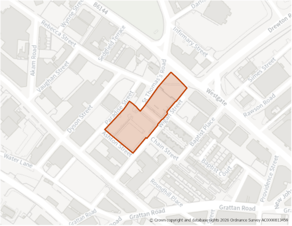
Site Size (ha) Gross: 0.62
Proposed Land Use: Housing
Minimum Development Capacity (Dwellings): 97
Site Type: PDL
Ward: Manningham
Settlement: City Centre
Ownership: Private
Delivery Timescale: Short 2025–2030 (1–5)
Site Specific Requirements
Design Principle
- The site should be developed for 97* family homes dweliings.
*In line with detailed planning application- see below.
Site Access, Highways and Transport
- Site access can be taken from the surrounding road network.
Natural and Historic Environment
- Site adjacent to Goitside conservation area and within 50m buffer of Beehive Inn (Grade II listed). The design of the site should be sensitively designed to avoid undue harm on these assets.
- The site is located within a bat alert area. An ecological survey will be required as part of any planning application to establish the extent/impacts as well as to identify appropriate mitigation.
Environmental Protection
- Site within Clean Air Zone.
Open Space and Green / Blue Infrastructure
- The site lies within the Bradford City Centre Opportunity Area, as identified in the Green and Blue Infrastructure Strategy (GBIS). The strategy should be consulted to identify opportunities for incorporating measures within the development that enhance the quality of, and connectivity to, the green and blue infrastructure network in this area.
Infrastructure Requirements
- Proportionate contributions to community infrastructure will be required, where appropriate, in line with Policies ID1 and ID2, and having regard to the Local Infrastructure Plan.
Planning Permission
- Detailed planning approval was granted post the Local Plan base date for 97 affordable family homes as part of a hybrid planning application including H1349 and H220 (25/03232/MAF- approved 25/2/26).
H220: Top of Town, City Village, City Centre Comment
Site Boundary
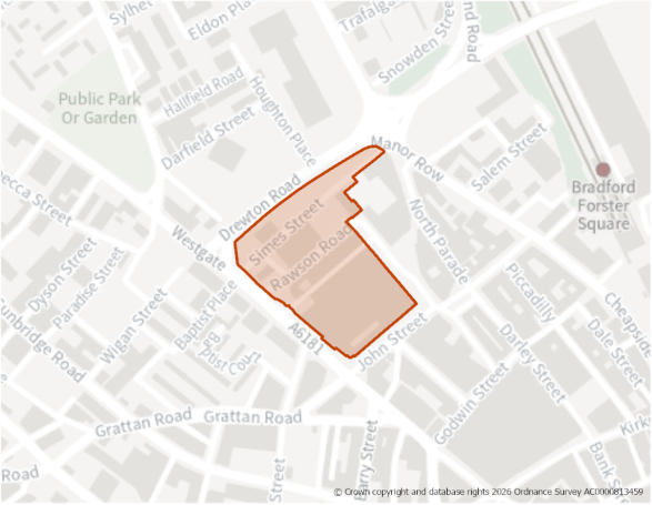
Site Size (ha) Gross: 2.61
Proposed Land Use: Housing
Minimum Development Capacity (Dwellings): 503
Site Type: PDL
Ward: City
Settlement: City Centre
Ownership: Mixed
Delivery Timescale: Medium 2030–2035 (6–10)
Site Specific Requirements
Open Space and Green / Blue Infrastructure
- The site lies within the Bradford City Centre Opportunity Area, as identified in the Green and Blue Infrastructure Strategy (GBIS). The strategy should be consulted to identify opportunities for incorporating measures within the development that enhance the quality of, and connectivity to, the green and blue infrastructure network in this area.
Infrastructure Requirements
- Proportionate contributions to community infrastructure will be required, where appropriate, in line with Policies ID1 and ID2, and having regard to the Local Infrastructure Plan.
Planning Permission
- A hybrid planning approval was granted post the Local Plan base date for up to 1,000 homes including 97 affordable family homes on H219 with the remainder on this site and H1349. (25/03232/MAF- approved 25/2/26).
H223: North Brook Street/Valley Road, City Centre Comment
Site Boundary
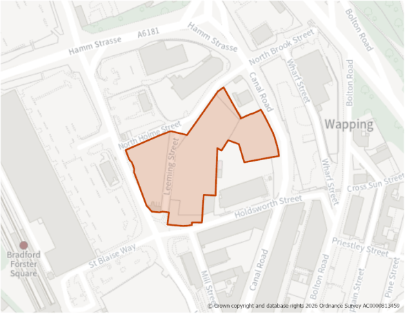
Site Size (ha) Gross: 1.25
Proposed Land Use: Housing
Minimum Development Capacity (Dwellings): 339
Site Type: PDL
Ward: City
Settlement: City Centre
Ownership: Private
Delivery Timescale: Medium 2030–2035 (6–10)
Site Specific Requirements
Design Principles
- The site contains a number of important road frontages. New buildings should be sensitively designed in line with Policy DS1 and define and enclose these routes in terms of their scale and building line and be over 5-7 storeys in height. At least 339 new apartments should be accomodated on the site at 300 dph net density and be of mixed size and type in line with Policies HO2 and HO3.
- Given the potential for flood risk in the area, the design of the site should ensure that any living accomodation is developed above ground level, provided that it can be shown to be safe for its lifetime and that safe access and egress can be achieved.
Site Access, Highways and Transport
- Site access should ideally be taken from Leeming Street but other options including Holdsworth Street would also be suitable.
Flooding, Water and Drainage
- The Level 2 SFRA carried out for this site indicates that some of it falls within Flood Zone 3b (functional floodplain), where the line of a culvert runs underneath the site, and may not pass the exception test. A site-specific flood risk assessment will be required at the planning application stage, and development must not take place in areas defined as Flood Zone 3b. The FRA must include a condition and capacity assessment of the culvert beneath the site.
- It is considered that development of the site would provide wider sustainability benefits to the community that outweigh the flood risk. In line with Policy CR4, a holistic and comprehensive approach to managing flood risk within the Bradford Beck corridor must be carried out. This may include watercourse and flood engineering, alleviation works and green and blue infrastructure investment as part of a package of measures to reduce flood risk across the city and to ensure the delivery of regeneration within the city centre, including this site.
Natural and Historic Environment
- Site is within a bat alert area. An Ecology survey may be required at the planning application stage. Early engagement with the Council's Biodiversity Officer is recommended.
- The buildings on the southern side of Holdsworth Street are Grade II Listed and they also form the northern edge of the Cathedral Precinct Conservation Area. The redevelopment of the southern end of the site will need to ensure that it relates sensitively to the character and setting of the area.
Environmental Protection
- Site lies within the Clean Air Zone and adjacent to a road where pollution levels are of concern. Developer should seek to provide landscape buffer to the western site boundary to mitigate against impacts.
- Site is within 150m buffer of a former landfill site. A Land Contamination Assessment – Phase 1 Report will be required as part of any planning application. Site also has potential for further contamination from historic land use which should be explored further at planning application stage.
- The site is partly within a mineral safeguarding area (coal minerals).
Open Space and Green / Blue Infrastructure
- The site lies within the Bradford City Centre Opportunity Area, as identified in the Green and Blue Infrastructure Strategy (GBIS). The strategy should be consulted to identify opportunities for incorporating measures within the development that enhance the quality of, and connectivity to, the green and blue infrastructure network in this area.
Infrastructure Requirements
- Proportionate contributions to community infrastructure will be required, where appropriate, in line with Policies ID1 and ID2, and having regard to the Local Infrastructure Plan.
H225: Beehive Mills, Smith Street Comment
Site Boundary
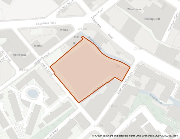
Site Size (ha) Gross: 0.78
Proposed Land Use: Housing
Minimum Development Capacity (Dwellings): 105
Site Type: PDL
Ward: City
Settlement: Bradford City Centre
Ownership: Private
Delivery Timescale: Long 2035+ (11+)
Site Specific Requirements
Design Principles
- The site should be developed for at least 105 dwellings at 150dph net density in line with Policy HO2. It should provide homes of mixed type and tenure in line with provisions of Policies HO3 and HO4.
- The site offers the opportunity for a non car based development/site with limited resident parking.
- Suitable landscaping and open space should be provided to the northern edge of the site with the Bradford Beck integrated as part of the design.
- Given the potential for flood risk in the area, the design of the site should ensure that any living accomodation is developed above ground level, provided that it can be shown to be safe for its lifetime and that safe access and egress can be achieved.
Site Access, Highways and Transport
- Site access from Tumbling Hill Street.
Flood risk
- The Level 2 SFRA carried out for this site indicates that a notable part of it falls within Flood Zone 3b (functional floodplain), where the line of two culverts run underneath the site, and may not pass the exception test. A site-specific flood risk assessment will be required at the planning application stage, and development must not take place in areas defined as Flood Zone 3b. The FRA must include a condition assessment of the culverts: Tumbling Hill Street culvert and the West Brook culvert beneath the site. Further modelling to understand the impacts of climate change on surface water flood risk to the site.
- It is considered that development of the site would provide wider sustainability benefits to the community that outweigh the flood risk. In line with Policy CR4, a holistic and comprehensive approach to managing flood risk within the Bradford Beck corridor must be carried out. This may include watercourse and flood engineering, alleviation works and green and blue infrastructure investment as part of a package of measures to reduce flood risk across the city and to ensure the delivery of regeneration within the city centre, including this site.
Natural and Historic Environment
- Site is within a bat alert area. An Ecology survey may be required at the planning application stage. Early engagement with the Council's Biodiversity Officer is recommended.
Environmental Protection
- Site lies within the Clean Air Zone and adjacent to a road where pollution levels are of concern. Developer should seek to provide new trees in mitigation.
- Site is within 150m buffer of a former landfill site. A Land Contamination Assessment – Phase 1 Report will be required as part of any planning application.
- Historic land use (Woollen Mill). Potential contamination from former use will need to be carefully considered.
Open Space and Green / Blue Infrastructure
- The site lies within the Bradford City Centre Opportunity Area, as identified in the Green and Blue Infrastructure Strategy (GBIS). The strategy should be consulted to identify opportunities for incorporating measures within the development that enhance the quality of, and connectivity to, the green and blue infrastructure network in this area.
Infrastructure Requirements
- Proportionate contributions to community infrastructure will be required, where appropriate, in line with Policies ID1 and ID2, and having regard to the Local Infrastructure Plan.
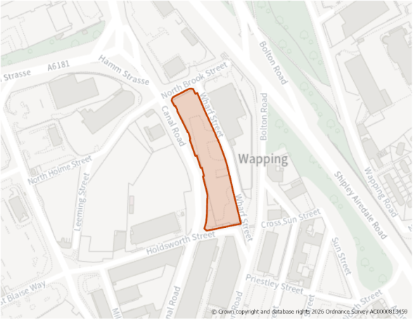
Site Size (ha) Gross: 0.48
Proposed Land Use: Housing
Minimum Development Capacity (Dwellings): 129
Site Type: PDL
Ward: City
Settlement: City Centre
Ownership: Private
Delivery Timescale: Long 2035+ (11+)
Site Specific Requirements
Design Principles
- The site adjoins Canal Road, one of the main routes into the city centre. The scale and design of new development should respond sensitively to the character of the adjacent Cathedral Precinct Conservation Area, animating the street at ground level in line with Policy DS1. The development should provide at least 129 homes at 300dph net density in line with Policy HO2. The development should contribute towards improving the pedestrian environment and footway on Canal Road and should include new tree planting along Wharf Street and potentially an on site open space.
Site Access, Highways and Transport
- Site access should be taken from Wharf Street.
Natural and Historic Environment
- Site is within a bat alert area. An Ecology survey may be required at the planning application stage. Early engagement with the Council's Biodiversity Officer is recommended.
- Site within 50m of Grade II listed building (29 Canal Road). The development of the site should mitigate against any perceived negative impacts on heritage through its design.
Environmental Protection
- Site lies within the Clean Air Zone and adjacent to a road where pollution levels are of concern. Developer should seek to provide new trees in mitigation.
- Site is within 150m buffer of a former landfill site. A Land Contamination Assessment – Phase 1 Report will be required as part of any planning application.
- The site is partly within a mineral safeguarding area (coal minerals).
Open Space and Green / Blue Infrastructure
- The site lies within the Bradford City Centre Opportunity Area, as identified in the Green and Blue Infrastructure Strategy (GBIS). The strategy should be consulted to identify opportunities for incorporating measures within the development that enhance the quality of, and connectivity to, the green and blue infrastructure network in this area.
Infrastructure Requirements
- Proportionate contributions to community infrastructure will be required, where appropriate, in line with Policies ID1 and ID2, and having regard to the Local Infrastructure Plan.
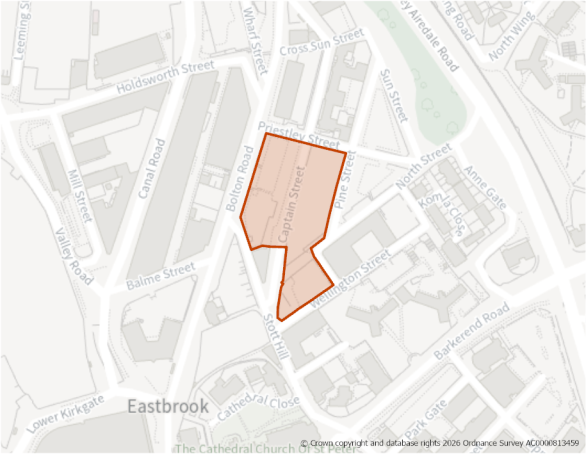
Site Size (ha) Gross: 0.70
Proposed Land Use: Housing
Minimum Development Capacity (Dwellings): 95
Site Type: PDL
Ward: City
Settlement: City Centre
Ownership: Private
Delivery Timescale: Long 2035+ (11+)
Site Specific Requirements
Design Principles
- Bolton Road is a key route into the city centre and new development should define the edge of the street, be of an appropriate scale and provide active frontages at ground floor level. The development of the site should deliver at least 95 new apartments or family homes at 150 dph net density, in line with Policy HO2.
Site Access, Highways and Transport
- Site access should be taken from Captain Street.
Natural and Historic Environment
- The site is within the Little Germany Conservation Area
- The site is opposite the Cathedral Church of St Peter, a Grade I Listed Building. There are also numerous other Grade II Listed Buildings in the vicinity of the site. The development of the site should be sensitive to the setting of the Cathedral and the conservation area to ensure no harmful impacts.
- The site is located within a bat alert area. An ecological survey will be required as part of any planning application to establish the extent/impacts as well as to identify appropriate mitigation.
Evironmental Protection
- The site is partly within a mineral safeguarding area (coal minerals).
Open Space and Green / Blue Infrastructure
- The site lies within the Bradford City Centre Opportunity Area, as identified in the Green and Blue Infrastructure Strategy (GBIS). The strategy should be consulted to identify opportunities for incorporating measures within the development that enhance the quality of, and connectivity to, the green and blue infrastructure network in this area.
Infrastructure Requirements
- Proportionate contributions to community infrastructure will be required, where appropriate, in line with Policies ID1 and ID2, and having regard to the Local Infrastructure Plan.
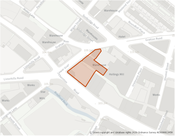
Site Size (ha) Gross: 0.20
Proposed Land Use: Housing
Minimum Development Capacity (Dwellings): 60
Site Type: PDL
Ward: Manningham
Settlement: City Centre
Ownership: Private
Delivery Timescale: Long 2035+ (11+)
Site Specific Requirements
Design Principles
- The site should be developed for at least 60 apartments at 300dph net density in line with Policy HO2. The design of the development should respond to the topography of the site and the key corner of Lower Grattan Road with Thornton Road and ensure active frontage to Thornton Road in line with Policy DS1.
Site Access, Highways and Transport
- Access should be taken from Lower Grattan Road.
Natural and Historic Environment
- Site is within a bat alert area. An Ecology survey may be required at the planning application stage. Early engagement with the Council's Biodiversity Officer is recommended.
Environmental Protection
- The site is within a mineral safeguarding area (coal minerals).
Open Space and Green / Blue Infrastructure
- The site lies within the Bradford City Centre Opportunity Area, as identified in the Green and Blue Infrastructure Strategy (GBIS). The strategy should be consulted to identify opportunities for incorporating measures within the development that enhance the quality of, and connectivity to, the green and blue infrastructure network in this area.
Infrastructure Requirements
- Proportionate contributions to community infrastructure will be required, where appropriate, in line with Policies ID1 and ID2, and having regard to the Local Infrastructure Plan
H232: Listerhills Road Comment
Site Boundary
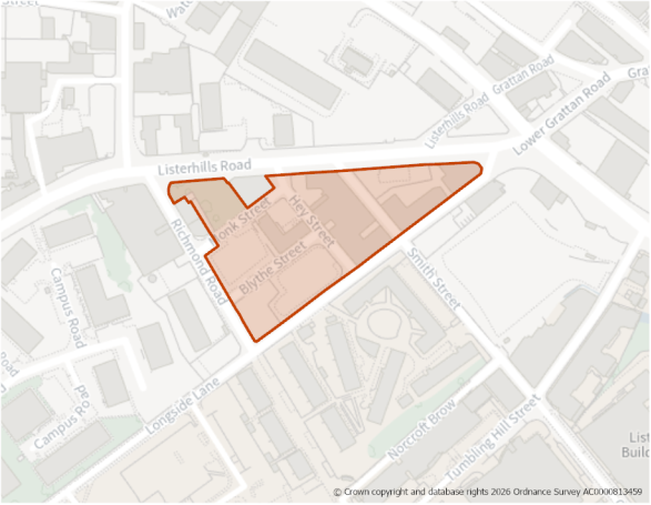
Site Size (ha) Gross: 1.33
Proposed Land Use: Housing
Minimum Development Capacity (Dwellings): 237
Site Type: PDL
Ward: City
Settlement: City Centre
Ownership: Private
Delivery Timescale: Medium 2030-2035 (6-10)
Site Specific Requirements
Design Principles
- The site contains land and buildings around a network of existing streets. The site should be redeveloped with existing buidings where possible retained. Any new buildings should respond positively to the surrounding streets and have a distinctive design with a strong feature at the corner of Listerhills Road and Longside Lane. The whole site should accomodate at least 237 homes at a net site density of 300dph.
Site Access, Highways and Transport
- Any vehicular access should be from Richmond Road, Longside Lane and Hey Street.
Flooding, Water and Drainage
- There should be no development above the Bradford Beck culvert which runs to the east of the site. Developers should explore the possibility of deculverting beck and adding new landscaping and open space. Proposals will need to be discussed and agreed with the Local Lead Flood Authority (City of Bradford MDC) and the Environment Agency at the planning application stage.
Natural and Historic Environment
- Site is within a bat alert area. An Ecology survey may be required at the planning application stage. Early engagement with the Council's Biodiversity Officer is recommended.
Environmental Protection
- Site lies within the Clean Air Zone and adjacent to a road where pollution levels are of concern. Developer should seek to provide new trees in mitgation.
- Site is within 150m buffer of a former landfill site. A Land Contamination Assessment – Phase 1 Report will be required as part of any planning application.
- The site is within a mineral safeguarding area (coal minerals).
- The site is located within a bat alert area. An ecological survey will be required as part of any planning application to establish the extent/impacts as well as to identify appropriate mitigation.
Open Space and Green / Blue Infrastructure
- The site lies within the Bradford City Centre Opportunity Area, as identified in the Green and Blue Infrastructure Strategy (GBIS). The strategy should be consulted to identify opportunities for incorporating measures within the development that enhance the quality of, and connectivity to, the green and blue infrastructure network in this area.
Infrastructure Requirements
- Proportionate contributions to community infrastructure will be required, where appropriate, in line with Policies ID1 and ID2, and having regard to the Local Infrastructure Plan.
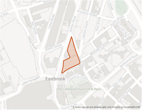
Site Size (ha) Gross: 0.30
Proposed Land Use: Housing
Minimum Development Capacity (Dwellings): 45
Site Type: PDL
Ward: City
Settlement: City Centre
Ownership: Other
Delivery Timescale: Long 2035+ (11+)
Site Specific Requirements
Design Principles
- Bolton Road is a key route into the city centre and new development should define the edge of the street, be of an appropriate scale and provide active frontages at ground floor level. The development should be sensitively designed and deliver at least 45 homes, which could be apartments or family homes at 150dph net density in line with Policy HO2.
Site Access, Highways and Transport
- Site access should be taken from Bolton Road.
Natural and Historic Environment
- Partially within a bat alert area. An Ecology survey may be required at the planning application stage. Early engagement with the Council's Biodiversity Officer is recommended.
- The site is within the Cathedral Precinct Conservation Area and adjacent to The Ring O’Bells Public House, a Grade II Listed Building. A number of other Listed Buildings are close to the site, including the Grade I Listed Cathedral Church of St Peter. The design of the site should ensure appropriate mitigation to reduce the impact of the development on the heritage assets in the area.
Environmental Protection
- Site lies within the Clean Air Zone and adjacent to a road where pollution levels are of concern. Developer should seek to provide new trees in mitigation.
- Site is partly within 150m buffer of a former landfill site. A Land Contamination Assessment – Phase 1 Report will be required as part of any planning application.
- The site is within a mineral safeguarding area (coal minerals).
- The site is located within a bat alert area. An ecological survey will be required as part of any planning application to establish the extent/impacts as well as to identify appropriate mitigation.
Open Space and Green / Blue Infrastructure
- The site lies within the Bradford City Centre Opportunity Area, as identified in the Green and Blue Infrastructure Strategy (GBIS). The strategy should be consulted to identify opportunities for incorporating measures within the development that enhance the quality of, and connectivity to, the green and blue infrastructure network in this area.
Infrastructure Requirements
- Proportionate contributions to community infrastructure will be required, where appropriate, in line with Policies ID1 and ID2, and having regard to the Local Infrastructure Plan.
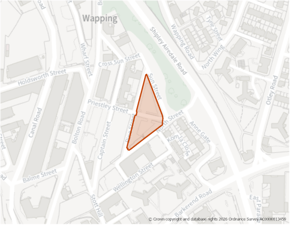
Site Size (ha) Gross: 0.32
Proposed Land Use: Housing
Minimum Development Capacity (Dwellings): 48
Site Type: Greenfield
Ward: City
Settlement: City Centre
Ownership: Private
Delivery Timescale: Long 2035+ (11+)
Site Specific Requirements
Design Principles
- The layout and scale of the buildings should respond to the sloping nature of the site. The development should accommodate at least 48 homes at 150dph net density in line with Policy HO2. It should incorporate complimentary landscaping to the the north eastern boundary of the site to mitigate against the impacts of the adjacent main road.
Site Access, Highways and Transport
- Site access should be taken from Priestley Street.
Natural and Historic Environment
- Site is within a bat alert area. An Ecology survey may be required at the planning application stage. Early engagement with the Council's Biodiversity Officer is recommended.
- The scale and design of new development should respond sensitively to the surrounding historic context, and safeguard the character and setting of the nearby Listed Buildings.
Environmental Protection
- Site lies within the Clean Air Zone and adjacent to a road where pollution levels are of concern. Trees and landscaping should be provided where possible.
- Site is within 150m buffer of a former landfill site. A Land Contamination Assessment – Phase 1 Report will be required as part of any planning application.
- The site is located within a bat alert area. An ecological survey will be required as part of any planning application to establish the extent/impacts as well as to identify appropriate mitigation.
Open Space and Green / Blue Infrastructure
- The site lies within the Bradford City Centre Opportunity Area, as identified in the Green and Blue Infrastructure Strategy (GBIS). The strategy should be consulted to identify opportunities for incorporating measures within the development that enhance the quality of, and connectivity to, the green and blue infrastructure network in this area.
Infrastructure Requirements
- Proportionate contributions to community infrastructure will be required, where appropriate, in line with Policies ID1 and ID2, and having regard to the Local Infrastructure Plan.
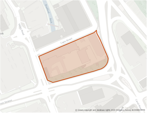
Site Size (ha) Gross: 0.95
Proposed Land Use: Housing
Minimum Development Capacity (Dwellings): 258
Site Type: PDL
Ward: City
Settlement: City Centre
Ownership: Private
Delivery Timescale: Long 2035+ (11+)
Site Specific Requirements
Design Principles
- The sites contains listed buildings which should be retained and brought back into use together with new buildings which should be well designed to compliment the existing buildings. These should be designed in accordance with Policies DS1 and DS3 and be of a similar scale to the existing and positively address the edges of the site particularly along Hamm Strasse. The development should provide at least 258 new homes at 300dph net density in line with Policy HO2. The landscaped verge alongside Hamm Strasse should be retained, but remodelled to integrate better with development on the site and provide useable space.
- Consideration should be given to the opportunity to deculvert the Bradford Beck watercourse and include it within the site design as part of a green blue corridor through the site.
Site Access, Highways and Transport
- Site access should be taken from Cape Street.
Flooding, Water and Drainage
- The Level 2 SFRA carried out for this site indicates that part of it is within Flood Zone 3b (functional floodplain) where the culverted Bradford Beck watercourse runs beneath the site. The change of use of the existing buildings may be acceptable provided it meets the flood risk guidance in the PPG.
- Within the areas of fluvial risk, more vulnerable uses must be situated on the upper floors and safe access and escape routes must be achievable.
- Property Flood Resilience measures should be considered within the site design to improve flood resistance and resilience of the existing buildings. In line with Policy CR4, proposals will need to demonstrate that structural condition of the culvert beneath the building will remain intact and safe for the lifetime of the development.
- It is considered that development of the site would provide wider sustainability benefits to the community that outweigh the flood risk. In line with Policy CR4, a holistic and comprehensive approach to managing flood risk within the Bradford Beck corridor must be carried out. This may include watercourse and flood engineering, alleviation works and green and blue infrastructure investment as part of a package of measures to reduce flood risk across the city and to ensure the delivery of regeneration within the city centre, including this site.
Natural and Historic Environment
- Site is within a bat alert area. An Ecology survey may be required at the planning application stage. Early engagement with the Council's Biodiversity Officer is recommended.
- The site contains part of the Grade II Listed Ambler Mills and Midland Mills Warehouses and is within 50m of other Grade II listed buildings. The regeneration of the site will enhance the area but sensitive design should ensure appropriate mitigation to reduce the risk of harm to the elements which contribute to the significance of these designated heritage assets.
Environmental Protection
- Site lies within the Clean Air Zone and adjacent to a road where pollution levels are of concern.
Open Space and Green / Blue Infrastructure
- The site lies within the Bradford City Centre Opportunity Area, as identified in the Green and Blue Infrastructure Strategy (GBIS). The strategy should be consulted to identify opportunities for incorporating measures within the development that enhance the quality of, and connectivity to, the green and blue infrastructure network in this area.
Infrastructure Requirements
- Proportionate contributions to community infrastructure will be required, where appropriate, in line with Policies ID1 and ID2, and having regard to the Local Infrastructure Plan.
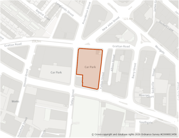
Site Size (ha) Gross: 0.25
Proposed Land Use: Housing
Minimum Development Capacity (Dwellings): 75
Site Type: PDL
Ward: Manningham
Settlement: City Centre
Ownership: Private
Delivery Timescale: Medium 2030-2035 (6-10)
Site Specific Requirements
Design Principles
- The development of the site should respond to the topography of the site and provide at least 75 homes at 300 dph net density in line with Policy HO2. Some basement or undercroft parking may be acceptable with access off Fulton Street.
Site Access, Highways and Transport
- Site access should be taken from Fulton Street or Tetley Street.
Natural and Historic Environment
- Site is partially within a bat alert area. An Ecology survey may be required at the planning application stage. Early engagement with the Council's Biodiversity Officer is recommended.
- Site with Goitside Conservation Area and partly within the 50m buffer of a Grade II listed building (Colonial House). Development proposals should respond sensitively to the surrounding historic context and safeguard the character and setting of nearlby listed buildings and conservation area.
Environmental Protection
- Site lies within the Clean Air Zone and adjacent to a road where pollution levels are of concern.
- The site is within a mineral safeguarding area (coal minerals).
- The site is located within a bat alert area. An ecological survey will be required as part of any planning application to establish the extent/impacts as well as to identify appropriate mitigation.
Open Space and Green / Blue Infrastructure
- The site lies within the Bradford City Centre Opportunity Area, as identified in the Green and Blue Infrastructure Strategy (GBIS). The strategy should be consulted to identify opportunities for incorporating measures within the development that enhance the quality of, and connectivity to, the green and blue infrastructure network in this area.
Infrastructure Requirements
- Proportionate contributions to community infrastructure will be required, where appropriate, in line with Policies ID1 and ID2, and having regard to the Local Infrastructure Plan.
H599: Barkerend Mill, Barkerend Road, Barkerend Comment
Site Boundary
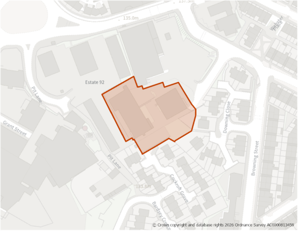
Site Size (ha) Gross: 0.49
Proposed Land Use: Housing
Minimum Development Capacity (Dwellings): 132
Site Type: PDL
Ward: Bowling & Barkerend
Settlement: Bradford North East
Ownership: Private
Delivery Timescale: Long 2035+ (11+)
Site Specific Requirements
Design Principles
- The development of the should should provide at least 132 dwellings at a net density of 300dph in line with Policy HO2 which should also include affordable housing in line with Policy HO4.
- The site contains access roads and parking areas for adjacent established non-residential development. The layout of the site will need to be mindful of the relationship between existing homes, commercial uses and private space and ensure new development is well designed.
Site Access, Highways and Transport
- The new access would join Harewood Street, where footways and streetlighting are present.
Natural and Historic Environment
- Part occupied by Grade II listed building at risk and in deteriorating condition. Development of the proposed site should strive to have an acceptable impact with the potential to improve the setting of the listed building and support its regeneration.
Environmental Protection
- Site is within a Development High Risk Area for coal mining, indicating that it contains one or more recorded former related features at surface or shallow depth. A Coal Mining Risk Assessment (CMRA) will be required as part of any planning application.
- Site is within 150m buffer of a former landfill site. A Land Contamination Assessment – Phase 1 Report will be required as part of any planning application.
- This site is located within the Clean Air Zone and development must be in accordance with the requirements set out in Policy CR1.
Open Space and Green / Blue Infrastructure
- The site lies within the Bradford City Centre Opportunity Area, as identified in the Green and Blue Infrastructure Strategy (GBIS). The strategy should be consulted to identify opportunities for incorporating measures within the development that enhance the quality of, and connectivity to, the green and blue infrastructure network in this area.
- Site is within [delete as appropriate] an area of low provision and high need for green and blue infrastructure. Development proposals should focus on carefully designed green and blue infrastructure to contribute towards site specific issues e.g. flood mitigation, urban cooling, etc.
Infrastructure Requirements
- Proportionate contributions to community infrastructure will be required, where appropriate, in line with Policies ID1 and ID2, and having regard to the Local Infrastructure Plan.
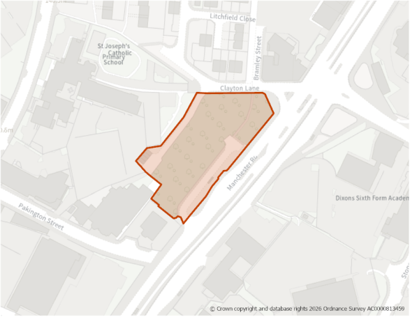
Site Size (ha) Gross: 0.52
Proposed Land Use: Housing
Minimum Development Capacity (Dwellings): 35
Site Type: PDL
Ward: City
Settlement: City Centre
Ownership: Public
Delivery Timescale: Medium 2030-2035 (6-10)
Site Specific Requirements
Design Principles
- The site should be developed at 75dph net density in line with Policy HO2 and should deliver at least 35 dwellings. These could be low rise apartments in one or more bocks or town houses.
- The site should be well designed and particular attention should be given to the adajcent Grade II listed building with sensitive design incorporated into the design in line with Policies DS1 and DS3.
- Landscaping will be required on the frontage of the site with Manchester Road, to screen and mitigate against the impact of this major highway onthe site by potential noise and air quality impacts.
Site Access, Highways and Transport
- Access from Clayton Lane only. No direct access will be accepted from Manchester Road.
Flooding, Water and Drainage
- The north western extent and south eastern extent of the site boundary has the potential for surface water flood risk. This is likely to be from hard areas connected with the previous use which shold be addressed by design.
Natural and Historic Environment
- The site adjoins Listed Buildings (Grade II - St Joesphs Presbytery, Pakington Street) and within 50m of other listed buildings. The design of the site should ensure any impacts can be mitigated.
Environmental Protection
- The site lies wholly within a 150m buffer of a former landfill site. A Land Contamination Assessment – Phase 1 Report will be required as part of any planning application.
- Site is within Clean Air Zone (CAZ) and an area where air pollution levels are of concern. Trees and landscaping will be required to mitigate against these impacts.
Open Space and Green / Blue Infrastructure
- The site lies within the Bradford City Centre Opportunity Area, as identified in the Green and Blue Infrastructure Strategy (GBIS). The strategy should be consulted to identify opportunities for incorporating measures within the development that enhance the quality of, and connectivity to, the green and blue infrastructure network in this area.
Infrastructure Requirements
- Proportionate contributions to community infrastructure will be required, where appropriate, in line with Policies ID1 and ID2, and having regard to the Local Infrastructure Plan.
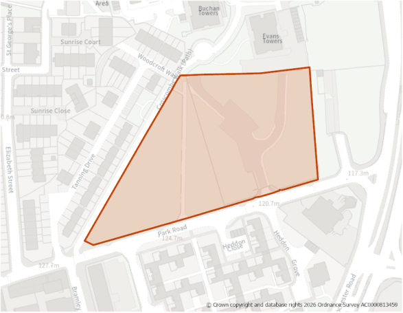
Site Size (ha) Gross: 1.44
Proposed Land Use: Housing
Minimum Development Capacity (Dwellings): 390
Site Type: PDL
Ward: City
Settlement: City Centre
Ownership: Mixed
Delivery Timescale: Long 2035+ (11+)
Site Specific Requirements
Design Principles
- The site should be developed at 300dph net density in line with Policy HO2. It should provide a mix of types and tenures in line with Polcies HO3 and HO4 but is particularly suitable for apartment development which should have a strong urban grain designed in line with Policies DS1,DS3 and DS4.
- The development should provide on site landscaping and open space and should ideally be developed alongside H1553 with interlinked spaces and footpath connections.
Site Access, Highways and Transport
- Access should only be taken from Park Road.
- The site should limit the amount of private parking provided.
Flooding, Water and Drainage
- A small area in the north of the site has the potential for surface water flood risk. This is likely to be from hard areas connected with the previous use which should be addressed by design.
Environmental Protection
- Site is within Clean Air Zone (CAZ) and an area where air pollution levels are of concern. Trees and landscaping will be required across the site to mitigate against these impacts.
Open Space and Green / Blue Infrastructure
- The site lies within the Bradford City Centre Opportunity Area, as identified in the Green and Blue Infrastructure Strategy (GBIS). The strategy should be consulted to identify opportunities for incorporating measures within the development that enhance the quality of, and connectivity to, the green and blue infrastructure network in this area.
Infrastructure Requirements
- Proportionate contributions to community infrastructure will be required, where appropriate, in line with Policies ID1 and ID2, and having regard to the Local Infrastructure Plan.
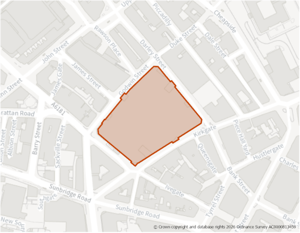
Site Size (ha) Gross: 1.32
Proposed Land Use: Housing
Minimum Development Capacity (Dwellings): 400
Site Type: PDL
Ward: City
Settlement: City Centre
Ownership: Public
Delivery Timescale: Medium 2030-2035 (6-10)
Site Specific Requirements
Open Space and Green / Blue Infrastructure
- The site lies within the Bradford City Centre Opportunity Area, as identified in the Green and Blue Infrastructure Strategy (GBIS). The strategy should be consulted to identify opportunities for incorporating measures within the development that enhance the quality of, and connectivity to, the green and blue infrastructure network in this area.
Infrastructure Requirements
- Proportionate contributions to community infrastructure will be required, where appropriate, in line with Policies ID1 and ID2, and having regard to the Local Infrastructure Plan.
Planning Permission
- A hybrid planning approval was granted post the Local Plan base date for upto 1000 homes including 97 affordable family homes on H219 with the remainder on this site and H220. (25/03232/MAF- approved 25/2/26).
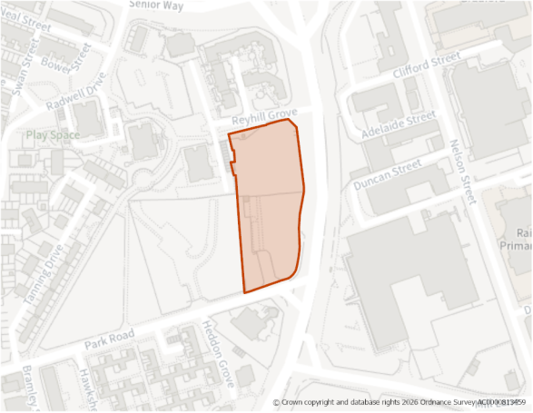
Site Size (ha) Gross: 0.75
Proposed Land Use: Housing
Minimum Development Capacity (Dwellings): 204
Site Type: PDL
Ward: City
Settlement: City Centre
Ownership: Public
Delivery Timescale: Medium 2030-2035 (6-10)
Site Specific Requirements
Design Principles
- The site should be developed at 300dph net density in line with Policy HO2. It should provide a mix of types and tenures in line with Polcies HO3 and HO4 but is particularly suitable for apartment development which should have a strong urban grain designed in line with Policies DS1,DS3 and DS4.
- The development should provide on site landscaping and open space and should ideally be developed alongside H1164 with interlinked spaces and footpath connections.
Site Access, Highways and Transport
- Access should be taken from Park Road.
- The development of the site should limit the amount of private parking provided.
Flooding, Water and Drainage
- A small area to the east of the site has the potential for surface water flood risk. This is likely to be from hard areas connected with the previous use which should be addressed by design.
Environmental Protection
- Site is within Clean Air Zone (CAZ) and an area where air pollution levels are of concern. Trees and landscaping will be required across the site to mitigate against these impacts.
Open Space and Green / Blue Infrastructure
- The site lies within the Bradford City Centre Opportunity Area, as identified in the Green and Blue Infrastructure Strategy (GBIS). The strategy should be consulted to identify opportunities for incorporating measures within the development that enhance the quality of, and connectivity to, the green and blue infrastructure network in this area.
Infrastructure Requirements
- Proportionate contributions to community infrastructure will be required, where appropriate, in line with Policies ID1 and ID2, and having regard to the Local Infrastructure Plan.
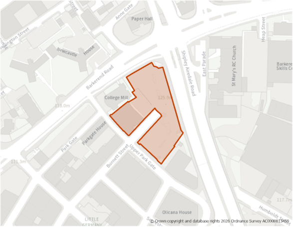
Site Size (ha) Gross: 0.40
Proposed Land Use: Housing
Minimum Development Capacity (Dwellings): 60
Site Type: PDL
Ward: City
Settlement: City Centre
Ownership: Mixed
Delivery Timescale: Long 2035+ (11+)
Site Specific Requirements
Design Principles
- Site comprises underused car parking and derelict listed building within a conservation area. The site should be developed for at least 60 dwellings at 150 dph net density in line with Policy HO2 in both a new building/s and via redevelopment of the existing building in line with Policies DS1 and DS3. The redevelopment of the site will make a positive impact on the area and should be designed to define the corners of the site particularly at the junction of Barkerend Road and Shipley Airedale Road to repair the urban fabric of this part of Little Germany.
- The development should provide an area of landscaping feature to the site boundary with Shipley Airedale Road and Barkerend Road.
Site Access, Highways and Transport
- Site access should be taken from Burnett Street.
Natural and Historic Environment
- Site is within a bat alert area. An Ecology survey may be required at the planning application stage. Early engagement with the Council's Biodiversity Officer is recommended.
- The site contains a Grade II listed Listed Building (7 Burnett Street) and is within the 50m buffer of several others, including The Paper Mill, Anne Gate. The development of the site should be sensitive to the potential impact from development and mitigate against any perceived negative impacts on heritage through its design.
- Within the Little Germany Conservation area.
Environmental Protection
- Site lies within the Clean Air Zone and is adjacent to a road where pollution and noise levels are of concern. The developer should seek to provide trees and appropriate landscaping to mitigate the impacts of the location of the site and to improve air quality.
Open Space and Green / Blue Infrastructure
- The site lies within the Bradford City Centre Opportunity Area, as identified in the Green and Blue Infrastructure Strategy (GBIS). The strategy should be consulted to identify opportunities for incorporating measures within the development that enhance the quality of, and connectivity to, the green and blue infrastructure network in this area.
Infrastructure Requirements
- Proportionate contributions to community infrastructure will be required, where appropriate, in line with Policies ID1 and ID2, and having regard to the Local Infrastructure Plan.
[1] Bradford District Green and Blue Infrastructure Strategy (2026) (CBMDC)
