
Draft Bradford District Local Plan - Preferred Options (Regulation 18) February 2021
(3) 1.0 Welcome
1.1 Introduction
1.1.1 Welcome to the Bradford District Local Plan. The Council first consulted in 2019 on scoping and then detailed changes to the adopted Core Strategy and since this time work has progressed with reviewing policies and our land supply to meet our growth needs over the next 15-20 years. This plan supersedes our previous work programme and pulls together policies, place-making and preferred options for site allocations for housing, employment and other uses into one document. The plan is still very much 'in draft' but shows clear direction and intent to be further refined as the plan moves from its current Regulation 18 stage to final Submission Draft (Regulation 19).
1.1.2 During 2020 much changed. The global pandemic has significantly impacted on our health and prosperity and drew special attention to the design of our homes, workplaces and living environments like never before. Communities have been ignited into action which has been inspirational and our ability to access nature, green and open spaces has been a top priority. It has focused further attention on transport and climate change, the value of high quality health infrastructure and services and also spotlighted the connections between poor housing, multiple deprivation and underlying health inequalities. Longer term retail trends in online shopping has accelerated but the value of local shops and services at the heart of vibrant communities is still undeniable. Affordable high capacity broadband has become a 'life essential' underpinning shopping, communication with family and friends and supporting education. Rebuilding and resetting for a proud and more resilient Bradford is central to our plan-making.
1.1.3 Government has been clear on changes to the current planning system and its intention for wholesale 'once in a generation' reform of England's planning system through its proposals in the 'Planning for the Future' white paper[1] published in August 2020 and a move to a streamlined and redesigned approach to plan-making. Change to the current planning system has taken place at pace in relation to permitted development rights, and changes to the use classes order and a new standard method for the calculation of housing need – placing a strong emphasis upon the redevelopment of brownfield land and urban regeneration.
1.1.4 The wider challenges of the climate emergency and tackling air pollution remain. We need to be growing to meet housing needs and provide rewarding economic opportunities but with a much stronger focus upon environmental standards and development in the right places that encourage people to walk, cycle and take public transport as the preferred modes of choice rather than by private vehicles. We need well connected healthy neighbourhoods, which are well designed to address our changing circumstances.
1.1.5 Bradford City is at the cusp of major change with significant investment in the pipeline including connecting communities through innovative public transport solutions and placing the city at the heart of regional connections for high speed rail. Rethinking the role of the city and its potential for new transport, homes, businesses and services is central to our plan.
1.1.6 The local plan however is very much a district-wide strategy. It focuses upon coordinated and holistic spatial planning within all our settlements and communities with a 'drill down' into the unique characteristics and opportunities within each area. At a more macro level the plan also needs to respond to the evolving West Yorkshire regional and devolution context and relationships with neighbouring authorities and key stakeholders.
1.1.7 Plan-making within such a rapidly changing environment is both challenging and exciting. The remainder of this section focuses upon our key plan directions in more detail and how you can get involved in helping shape Bradford District now and for the future.
1.2 Bradford District Local Plan – Key Directions
Simplifying Our Focus
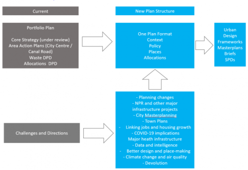
1.2.1 The current local plan consists of a portfolio of planning documents including the adopted Core Strategy DPD, two Area Action Plans (Bradford City Centre and Shipley and Canal Road Corridor); the Waste Management DPD and carried forward policies from the Replacement Unitary Development Plan (RUDP). The Bradford District Plan radically simplifies this structure to a single planning document.
1.2.2 There are a number of local and national drivers shaping this new plan direction:
- Clearer plan-making – with policy and site considerations worked up in parallel.
- Potential major infrastructure investment providing the catalyst to revisit city masterplanning and the delivery of the City Centre Area Action Plan.
- Embedding site allocations within an increasing complex range of policy considerations and moving forward with a more area based approach overall.
- Setting the foundations for a single plan to move forward within a revised national planning context focused more explicitly on area based planning.
Figure 1 below provides an overview of the new plan-making approach together with wider context.
Figure 1.1: Moving from Portfolio to Single Plan
1.2.3 The Local Plan together with adopted neighbourhood plans form the overall development plan for the District and in parallel to the producing the local plan support for neighbourhood plan work is ongoing. As set out in national planning policy neighbourhood plans should support the delivery of strategic policies contained in local plans or spatial development strategies and should shape and direct development that is outside of these strategic policies
1.2.4 As part of the Core Strategy Partial Review (CSPR) in 2019, the Council received over 3900 representations, these ranged from local residents, residents outside the District, planning consultants / agents, developers, statutory consultees, interest groups, parish and town councils, internal departments and other parties, councillors and MPs. Detailed feedback on the comments received are published within the Consultation Statement.
1.2.5 In developing the local plan, consultation feedback has helped shape key plan directions, which are summarised briefly below (not an exhaustive list):
- Plan period – now extended from 2037 to 2038 in reflection of potential slippage in the local plan timetable.
- Climate change – general support for the policy but strengthening its aims which have been carried forward into the updated policy in this plan.
- Broad location of development – very strong concerns raised over development within the Tong Valley area in particular. The plan overall proposes a balanced approach to growth and continues to include development to the east of Holme Wood but this is more clearly defined and the scale of growth proposed recognises the environmental and other concerns in this area and would need to come forward through a high quality masterplan for both housing and employment.
- Green Infrastructure – need for further extension of the network recognised and further developed within the policies in this plan.
- Green Belt and Evidence – a number of representations focused upon the need for a strengthened case and evidence for Green Belt release together with strong opposition to the sue of Green Belt land for development. The case, evidence and approach to development including the requirement for the release of Green Belt land is further detailed in the plan and supporting evidence.
- Distribution of Growth – wide range of views on the scale and location for growth which has been taken into consideration in the area strategies in the plan and selected range of preferred allocations.
- Employment Land – job and employment forecasts variously considered too low and too high. Updated evidence work makes the case for an increase in employment land requirements and suitable sites have been identified to deliver employment growth in a sustainable manner.
- Transport policies – policies needed to be clearer and are generally not ambitious enough. The full set of transport policies have been reviewed and updated substantially to place a stronger focus upon active travel and sustainable transport plus potential new strategic investment opportunities.
- Housing requirement – wide range of views raised including substantial opposition to lowering the housing requirement from the current Core Strategy figures. The housing need and requirement is discussed at length within the Local Plan and supporting evidence and the plan is now informed by the outcome of the detailed site assessment work which concludes that sustainable development can be obtained at a very similar level of housing growth to that proposed in the CSPR.
- Housing density and sources of supply – further information now contained with the plan in relation to supply specifics and density expectations.
- Gypsy and Traveller Needs Assessment – concerns over gaps in the research which have been addressed through updated evidence and policy.
- Flood risk and biodiversity – further work progressing on flood risk evidence and the environmental policies in the plan have been updated in reflection of comments received.
1.2.6 The Local Plan is designed to be an integrated strategy including a vision with strategic objectives and a focused set of strategic and development orientated planning policies. The relevant policies together with additional information on local socio-economic factors have been used to structure profiles for each settlement within the District and a set of area strategies. These strategies contain information on important local features and preferred site allocations - primarily housing and employment. Each preferred site allocation also has a pro forma which provides detailed information about key constraints, opportunities and why the site is suitable for allocation.
1.2.7 While the structure of the overall local plan has been technically simplified it remains broad ranging and extensive in scope. The plan is supported by a range of technical evidence and background material which is published as part of the consultation and the development of the plan is informed by iterate work through the Sustainability Appraisal (SA), Habitat Regulations Assessment (HRA) and other impact assessments.
Towards a Green Recovery and Balanced Growth
1.2.8 The local plan for the first time since the RUDP sets out our combined growth ambitions, planning policies and portfolio of sites. We are seeking to deliver to 2038:
- A housing requirement of 1,704 dwellings per annum or 30,672 homes over the 18 years of the plan (2020-2038).
- Almost 8,000 new affordable homes.
- Over 80 hectares of employment land.
- Almost 29,000 jobs over the plan period.
- 325 housing sites
- Designation of 1,693 open spaces totalling 2,781ha of land
- Protection of 1 special protection area, 4 SSSIs, 4 local nature reserves, 108 local wildlife sites and 16 local geographical sites.
1.2.9 Looking beyond the numbers we also need to ensure that the plan delivers growth in a sustainable manner – supporting development in the right locations and making the best use of our valuable local resources. In practical terms this translates to:
- Protecting our environmental resources and requiring new development to leave biodiversity in a measurably better state than beforehand, contribute towards mitigating impacts in some of our most valuable landscape and habitat areas and minimise impact on heritage assets.
- A strongly committed approach to tackling climate change, improving air quality and creating healthier communities – supporting significant improvements in environmental build standards, energy use and tackling air pollution combined with a further focus upon health impacts, active travel, enhancing public transport uses and developing green infrastructure networks.
- Prioritising the allocation of brownfield and non-Green Belt sites first and then taking a measured and sensitive approach to Green Belt release where further growth cannot be accommodated within current settlement boundaries.
- Ensuring sufficient quantity and quality of employment land to support and sustain economic recovery and growth and ensuring that opportunities for diversification into the green economy are not lost and local people benefit from growth through jobs, skills and training.
- Balancing growth across sustainable settlements by ensuring that local services and facilities continue to thrive and affordable and other types of housing support local needs. Growth is underpinned by sufficient infrastructure – open spaces, community and health facilities and digital networks.
Maximising Regeneration Opportunities
1.2.10 Bradford City Centre is a key hub of potential high profile investment opportunities including high speed rail and mass transit which could transform major parts of the city enabling significant growth in housing and employment (including a wide range of new services and facilities) as well as new green open spaces and high quality public realm.
1.2.11 The vision for Bradford City is about ensuring we have a more liveable and healthy urban environment which appeals to everyone – residents, workers and tourists alike, both young and old and across all our communities. It needs to be better connected in terms of cycling and walking, with improved safety and public realm features including trees and landscaping, and have a critical mass of people working and living in the city supporting local services and facilities. The need for improved community facilities is also central to this vision. Progress has already been made on a number of exciting projects including the redevelopment of Bradford Markets and a new 'city village' as part of a 10-year regeneration plan for the 'top of town' area.
1.2.12 The local plan integrates a headline review of the status, delivery and future options for the city centre area action plan sites, within a refreshed planning framework. It renames some city quarters to be more reflective of their uses and future directions and includes an extension to the core city centre to include an enlarged southern gateway as a major regeneration area, with an 'area of search' for at least 2,500 dwellings. We are increasing our city centre delivery target from 4000 in the CSPR to a minimum of 7000 dwellings. The plan features a focus upon radically diversifying our urban housing offer to deliver different types of homes – townhouses, terraces, duplex schemes and apartments but within a more integrated framework connected to the urban design ambitions set out in the plan and the Council's published housing and neighbourhoods design guide (SPD).
1.2.13 There is considerably more work to do, and detailed proposals for the southern gateway area will be developed further through masterplanning and in conjunction with key stakeholders. The plan is clear that there needs to be a more coordinated approach to growth and development to provide confidence in investment and transform parts of our urban fabric.
1.2.14 The local plan remains committed to supporting the transformation and economic, physical and social regeneration of the wider Regional City of Bradford and its diverse neighbourhoods including Shipley and Canal Road Corridor, inner city areas of Manningham and Little Horton; North East Bradford – Ravenscliffe and Thorpe Edge; East Bradford – Barkerend, Beech Grove, Bradford Moor, Thornbury, Woodhall and Laisterdyke; South East Bradford – Bierley and Holme Wood; South West Bradford – Buttershaw and Woodside and West Bradford – Allerton. The local plan retains a focus upon the different quadrants within the wider regional city but the analysis and strategy for change is far more about local areas and neighbourhoods. This forms a major feature of the plan under section 5.
1.2.15 Holme Wood remains an important regeneration priority within Bradford South East – there is a need to integrate new investment in housing to support, retain and improve local services and facilities. It also needs to be better connected to improved public and green spaces and green infrastructure corridors.
1.2.16 The Council has reviewed further extension options to Holme Wood and the A650 Westgate Hill Street / Tong Street corridor and the range of constraints within the area which is detailed under section 5. The Local Plan now includes a more fine-grained approach to development in this area including a modest extension to Holme Wood to the north east of the settlement edge (Ned Lane) and a larger 'village scale' development integrating housing and employment to the south east broadly aligned to a series of access points off Westgate Hill Street. Both proposed development areas take a sensitive approach to growth, which is very similar to the original neighbourhood plan vision for the area. The Local Plan is also clear on a need for a step change in housing quality and provision of new employment space in this part of Bradford - along the A650 key gateway route in particular – to be supported through a coordinated masterplan with strong environmental credentials.
1.2.17 Within the Airedale corridor Keighley continues to be identified as a key regeneration area. The plan proposes a wide portfolio of housing development opportunities and continues to support the town's economic ambitions through employment land allocations. A further 'broad location for housing growth' has been identified within Keighley for the station quarter / town centre area for additional housing growth following further detailed urban capacity analysis and potential masterplanning.
1.2.18 The plan establishes a balanced and highly ambitious approach to regeneration and housing growth within the context of the Bradford economy and viability challenges recognises that Government, through setting the new standard method for housing, is looking for an increase in dwellings of 35% in the largest cities and urban centres in England (including Bradford) above what is considered our base housing requirement (1704 dwellings per year). This would translate to broadly an extra 10,000 dwellings within primarily the Regional City of Bradford. The plan recognises that this is extremely challenging and would require substantial investment and support to deliver within the plan period for this to be achievable and sustainable. Linked to this consultation, the Council is looking for your views on additional sustainable urban sites which could assist with delivering this additional uplift which have not already been considered as part of the Council's strategic land assessment.
Integrated District-wide Strategy
1.2.19 The Local Plan is a District wide strategy which utilises the same settlement hierarchy as that developed through the adopted core strategy. While it retains the four sub areas of the Regional City of Bradford (including Shipley and Lower Baildon), Airedale, Wharfedale and the Pennine Towns and Villages, it weaves together a series of new more detailed area profiles which combine data, emerging policy and the local plan evidence base to provide a stronger context to growth. This approach signals a move to the integration of intelligent data-sets to support plan-making. The full background material informing the area profiles is published alongside the local plan.
1.2.20 The plan also introduces another spatial layer (local planning areas) below the sub areas which allow a shift in focus to area strategies for each of the settlements and a far more fine-grained approach to local planning. The area strategies feature initial ideas about the future spatial directions of the settlements and allows for a more holistic and neighbourhood level approach to planning. The area strategies include information on transport connectivity, local facilities, important local assets, open spaces and opportunities and provide the context for preferred site allocations which are detail within the strategy plans. Central to our concerns is a move to a more place-based approach to plan-making.
1.1.21 As with other aspects of the draft plan, the work on the local area strategies is very much a conversation about growth and opportunities.
High Quality Neighbourhoods and Housing
1.2.22 It is widely recognised that there is a need for a step change in the quality of neighbourhood design and housing in the District. The urban design policies within this plan have been refreshed and continue to underpin the Council's Homes and Neighbourhoods Design Guide.
1.2.23 With a move to a more place-based plan structure there are clear benefits to thinking more collectively about considering growth options within the wider context of open spaces, green infrastructure, biodiversity, recreation and leisure, cycling and walking routes, access to services and communities together with the key components of healthier communities.
1.2.24 The Local Plan sets some strong individual standards for new housing in terms of environmental and design benchmarks, accessibility and minimum space requirements. There is however more that can be done and the breadth and range of site opportunities and constraints within the District calls for imaginative and creative solutions for delivery. The plan includes a widened focus upon housing innovation, different types and approaches to urban housing; modern methods of construction; specialised housing and accommodation, and specific policy directions on self and custom build housing.
1.2.25 Diversifying our housing offer to ensure high quality housing is available to all is a core local plan objective.
1.2.26 In supporting the creation of high quality neighbourhoods and housing across the district, it is essential that appropriate infrastructure is provided in the right places, at the right time to address the impacts of growth. This means ensuring that there is sufficient capacity in local schools and medical centres and providing open space and green infrastructure together with improved transport networks.
1.3 Preparation of the Plan and Evidence
1.3.1 The Local Plan is still a draft document and strategy with an emerging and growing set of supporting material and evidence. With this Plan there are updates to the evidence base on the strategic land assessment, housing, demographic and employment topics together with the release of extensive new material on open space, heritage, viability, area data and the Green Belt. The range and scope of the evidence material is set out in Section 2 of the plan.
1.3.2 In addition to a refreshed and updated set of evidence, the Local Plan is also accompanied by a consultation statement that captures the representations raised at the last consultation stage (core strategy partial review) and various appraisals and impact studies including the Sustainability Appraisal (SA), updated Habitat Regulation Assessment (HRA), Health Impact Assessment (HIA) and Equality Impact Assessment (EqIA). An update to the previously published Duty to Cooperate Action Plan is also included within the consultation material.
1.3.3 As a plan in development, further work is scheduled to progress on additional evidence base material between this stage of plan-making (Regulation 18) and the next of the plan (Regulation 19). Much of this work is detailed again within Section 2 of the plan.
1.3.4 Importantly, as part of progressing the evidence base, this plan consultation is also accompanied with a focused call for sites covering minerals and waste, Gypsy and Traveller sites; renewable energy sites; specialist housing and accommodation; custom and self-build sites and further urban housing options.
1.4 Plan Status
1.4.1 This is a formal consultation on the Draft Bradford District Local Plan – Preferred Options (Regulation 18). It is as noted previously a plan in development and as such there is a degree of flexibility to the plan document itself and the way in which we ask questions and present material. Under the planning regulations, the consultation must run for a minimum of six weeks.
1.4.2 There has been a number of key changes to the Local Plan production and timescales since we last consulted on the review of the core strategy and a technical note is published alongside the Local Plan on the Council's Local Development Scheme (LDS) which will be validated through the Council's Executive very shortly.
1.4.3 The next stage in the development of the plan will be the publication of the Local Plan – Publication Draft (Regulation 19), which will set out the Council's final position on the plan and the version which it intends to submit to the Secretary of State for public examination following further consultation on its 'soundness'.
1.5 Local Plan Structure
1.5.1 The Bradford District Local Plan is an integrated single plan with the following sections:
Section 2: Introduction – including the district portrait, spatial vision and strategic objectives.
Section 3: Strategic Policies – high level strategic policies which set out the overall core land use planning directions for the district.
Section 4: Thematic Policies – detailed planning policies covering the economy, transport, housing, environment and infrastructure.
Section 5: Local Area Profiles and Allocations – local area information, areas strategies and allocation detail.
Section 6: Implementation, Delivery and Monitoring – infrastructure planning, viability, delivery and performance monitoring.
1.5.2 Maps and diagrams are used throughout the document to help describe characteristics and features of the District, illustrate the vision and explain policy approaches. The key diagram shows the main spatial strategy and policy elements of the plan and is detailed under Section 3. The policies map is a key aspect of the plan which includes the main plan allocations and designations and is available in an interactive format allowing for detailed analysis.
1.5.3 The plan should ideally be read as a whole as there are often connections across policy areas and in relation to site allocation proposals.
1.5.4 The technical evidence produced to support the development of policies, allocations and designations is available on the Council's OpusConsult web portal and dedicated local plan web pages.
1.6 Approach to Consultation
1.6.1 The Council strongly welcomes representations on the emerging new Local Plan with the formal consultation period running from Monday 8th February to Wednesday 24th March 2021.
1.6.2 As with many activities, the consultation at this time will be held online only. The Council is however using new consultation software (OpusConsult) to facilitate improved access to information. To explain the plan in more detail, the Council is also hosting a series of publicised online events on planning policy topics, local area strategies and site allocations. Information on the plan and hot topics will also be communicated through the relevant Council social media accounts and Stay Connected e-mail alert service. The broad overall approach to consultation is set out in the published engagement plan.
1.6.3 Temporary changes to the planning regulations due to the pandemic mean that Local Planning Authorities no longer have to formally deposit the plan with supporting documents at deposit points around the District (mainly libraries). Where requests are made for printed hard copy information – this will be considered on a case by case basis. Large information requests may incur a charge. As all members of the Local Plan team are currently working remotely there may be delays in accessing paper copy requests for information and representation material sent to the Council's offices. All interested parties are encouraged to submit representations electronically (ideally via OpusConsult) during these exceptional times.
1.6.4 If you have any questions regarding this consultation, please contact the Local Plans Team.
Email: planning.policy@bradford.gov.uk
Phone: 01274 433679
[1] MHCLG White Paper: Planning for the Future (August 2020)