
Draft Bradford District Local Plan - Preferred Options (Regulation 18) February 2021
Bradford City Centre
Introduction
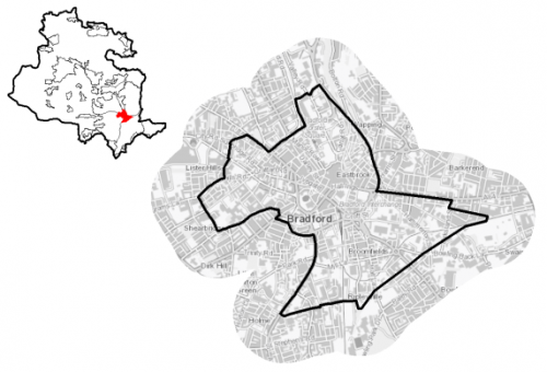
5.1.1 Bradford city centre is located at the heart of the District. The city centre is the key location for employment, retail, leisure and culture and the hub for public, commercial and civic services in the District. The city centre includes the main shopping, civic, entertainment and business district and also more peripheral areas such as Little Germany, Goitside, and the College and University campuses and Southern Gateway. The city centre is located to the south east of the District and falls within the Bradford West Parliamentary Constituency and City Ward.
Figure 1: Location Plan
5.1.2 The City of Bradford has a proud industrial and architectural heritage. Much of this built heritage still remains today including City Hall, the Wool Exchange and the merchant's quarter of Little Germany. There are over 100 Listed Building within the city centre. In recent years, Bradford city centre has been the focus of significant investment, reinforcing its role as a driving force of economic growth and prosperity. The city centre has seen investments in major developments. This includes sizeable investment in the University and College estate and over £130m, since 2010, in public realm, new hotels, Grade A Office Space, the Broadway shopping centre, and the award winning Bradford City Park.
5.1.3 The city centre has a population of 9,960 with a very large percentage of the population (78.9%) falling within the working age category (16-64). It has a lower percentage of residents (18.5%) who are aged under 15, compared to the West Yorkshire and national averages (20.6% and 19.2% respectively), whilst it has a significant below average population of those over 65. The ethnic composition of the city centre is very diverse. The largest percentage (around 58.8%) of the population identify as being of Non White ethnicity, which is significantly above the West Yorkshire average (18.2%). Around 38.1% of the population identify themselves as of Asian ethnicity, compared with 13.1% in West Yorkshire. Household composition is also very different to the regional picture, with the largest number of households (44.9%) consisting of one person households (aged under 65) compared to the West Yorkshire average (19.3%).
Planning for Prosperity
5.1.4 The Local Plan settlement hierarchy identifies the city centre within the Regional City of Bradford as the prime focus for housing, employment, shopping, leisure, education, health and cultural activities and facilities in the District. There is a key focus on transforming its economic, environmental, physical and social conditions to support its long term regeneration. The City Centre is also identified by the Local Enterprise Partnership as a Spatial Priority Area (SPA) Main Urban Centre for investment to support growth and regeneration via public sector investment.
5.1.5 The SPA designation is also related to the Bradford's selection by Government to receive support from the Transforming Cities Fund and West Yorkshire-plus Transport Fund. The Leeds City Region Transforming Cities Fund programme is a major new programme of investment that aims to deliver transformational, new infrastructure and help create a step change in travel across the region. In Bradford there will be four major transport schemes focused on the city centre and costing up to £80 million, including transforming Bradford Interchange the city's primary gateway, to become a major transport hub. The Local Plan will have a key role in assisting the delivery of future investment in the city centre.
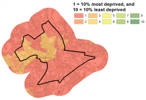
5.1.6 The city centre falls within the City Ward which is identified as being within the 10% most deprived wards in England. The City Ward is ranked 7th of 30 wards in the District for the Index of Multiple Deprivation. Figure 2 shows the overall picture of deprivation in Bradford
Figure 2: Bradford - Index of Multiple Deprivation
Economy and Employment
5.1.7 The economic activity rate in Bradford is lower (54.4%) than the West Yorkshire average (68.5%) and consists of a lower percentage of full-time employees. Annual household income at £29,999 is lower than the West Yorkshire average (£38,499) with the largest employment sectors locally being retail, accommodation & food services and manufacturing. There are higher proportions of people employed in elementary occupations compared to the West Yorkshire average and less occupied in managerial and administrative occupations and in professional occupations (24.9%) compared to West Yorkshire average of 27.9%.
5.1.8 The city centre is the main economic, civic, retail and service centre serving the District, and has a large employment base. The city centre is the key location for employment in the District. It is home to over 2,000 businesses (1 in 6 of all jobs in the district) which generate 31% of the District's GVA. These include 10,000 jobs in the financial and business services sector; 12,000 in the public sector; 3,500 retail jobs; and significantly for the city over 3,800 jobs in higher and further education. On the periphery, there are also significant areas of general industry. The City Centre also benefits from good connections to surrounding main urban centres including Leeds, Manchester and London, although, improvements are planned.
5.1.9 The City Centre has seen extensive office development in recent years facilitating growth and employment in key sectors, such as financial and business services industries. However, historically the city centre has suffered from a lack of quality office space, and consequently, the city centre does not have a recognised central business district.
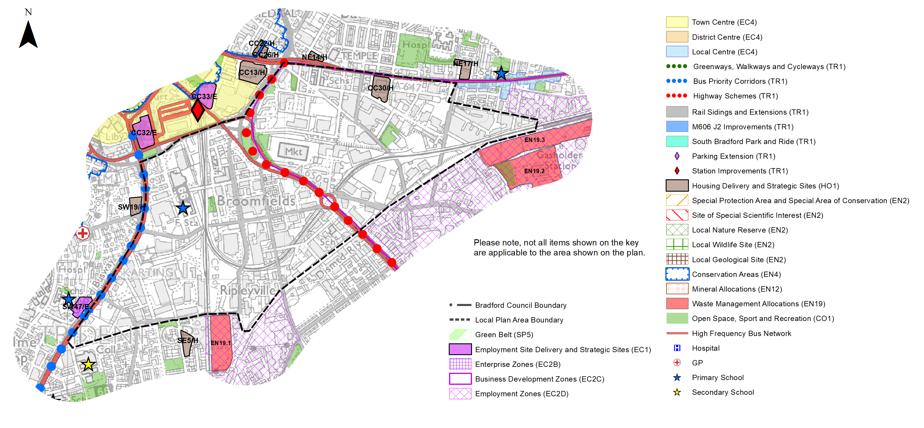
5.1.10 The main employment area is located in the Southern Gateway, south of the main city centre. A large part of the Business Development Zone (BDZ) is also identified in the Southern Gateway. Three specific commercial led land allocations are proposed for this area (CC31/E, CC32/E, CC33/E), located within the Central Civic Business and Leisure District. It is expected that the City Centre will be the priority area for Grade A office developments. This is in line with the priority for regeneration and the creation of a revitalised central business District which will make a significant contribution to employment floor-space provision, whilst supporting key employment sites within the city centre. In addition, the plan will support the growth and development of the University of Bradford, Bradford College, further and higher education institutions, hospitals and research institutions and other creative industries.
5.1.11 Table A provides details of the preferred employment site allocations within the city centre. The preferred employment site allocations are also identified on the Policies Map and within site pro formas, together with the local strategies map for each plan area.
Retail
5.1.12 As the largest centre in the District, Bradford City Centre forms the main retail and service centre serving the District. Bradford is designated in the retail hierarchy as a City Centre, which is the focus for a wide diversity of economic activity, including significant offices, residential, convenience and comparison retail including the traditional (and specialist) markets, leisure, entertainment, arts, culture, tourism, intensive sports and recreation uses and the priority centre for promotional events and activities.
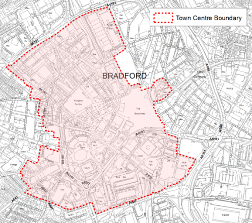
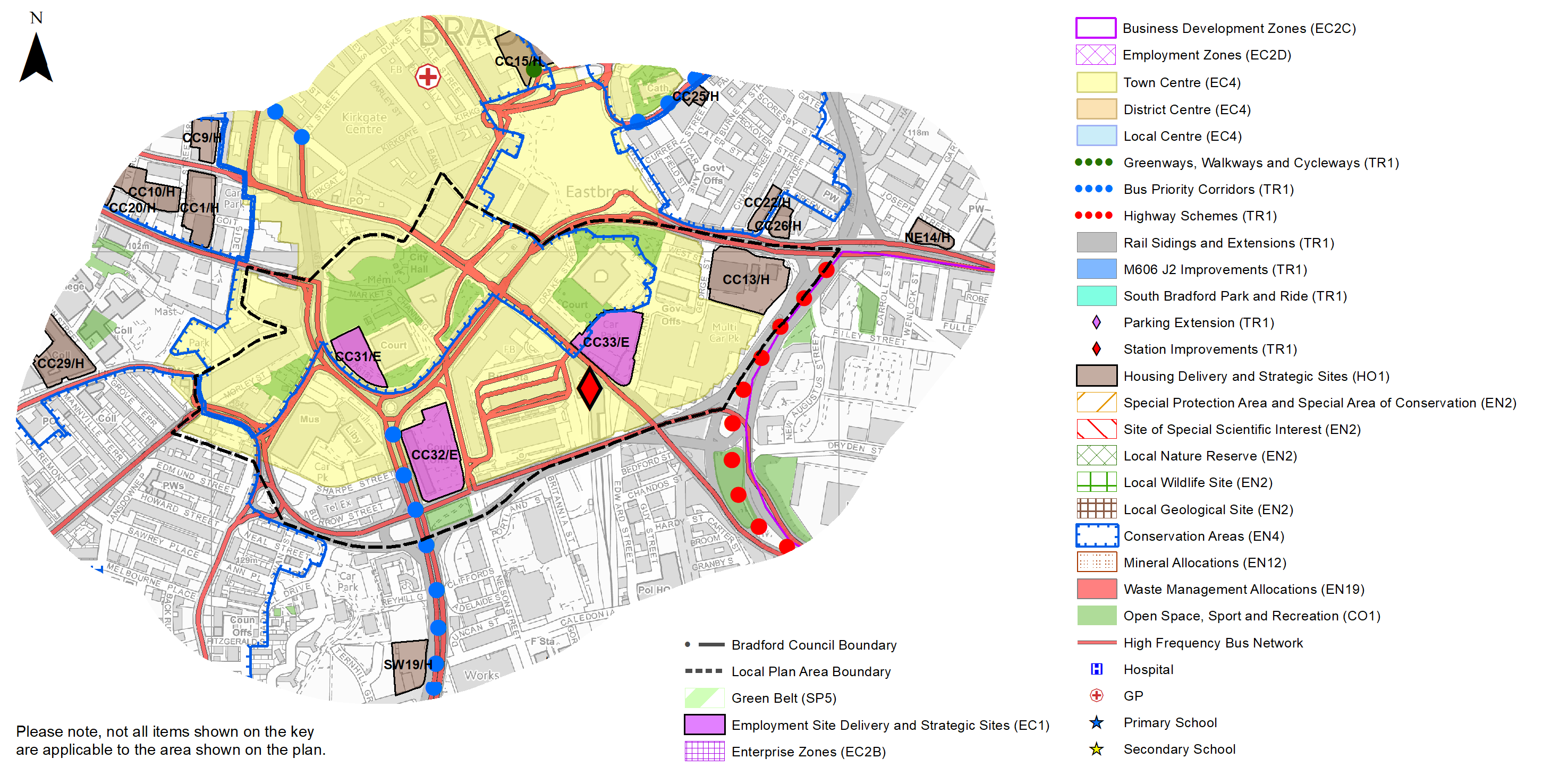
5.1.13 The centre is focused on City Park and the surrounding Historic Core of Broadway, Market Street and Darley Street. The extent of the City Centre boundary and Primary Shopping Area are shown on the Policies Map and figure 4 below shows the City Centre area.
Figure 4: Bradford City Centre
5.1.14 Bradford has a strong historic centre and has attractive areas of recent high quality public realm improvements and is supported by a Business Improvement District (BID). The delivery of the Broadway Shopping Centre has resulted in the city centre being well served in terms of a modern retail offer, and provides a cohesive retail shopping area by linking the Kirkgate Centre and Forster Square Retail Park. The City Centre also has a wide range of leisure uses including the National Media Museum, the Alhambra Theatre, galleries, the Leisure Exchange, and the bars/clubs in the West End, Sunbridge Wells and Top of Town. With further public realm improvements including the development of a new entertainment venue 'Bradford Live' which will offer modern concert hall facilities in the former Bradford Odeon building and a new purpose built market building on Darley Street with supporting new food and drink uses, Bradford has the potential to transform its visitor experience.
5.1.15 The Retail and Leisure Study (2019) suggests that the city centre is a strong performing centre but with areas of improvement including;
- high vacancy rates,
- the ring road which acts as a significant barrier for access to the City Centre
- below average representation of financial and business services.
5.1.16 In relation to new comparison floor-space, it is considered that Bradford City Centre alongside Keighley Town Centre should be the focus for new comparison retail floor- space in the District with opportunities to further enhance the centre's comparison goods offer via existing in-centre stock. In terms of convenience retail floor-space a large food store in the city centre would deliver significant qualitative benefits, however the focus for Bradford City Centre should be on delivering the replacement of Oastler Market with the proposed new market building at Darley Street.
Transport and Accessibility
5.1.17 Bradford City Centre is a major transport hub with good regional transport connections to Leeds, in the East and Central Lancashire, Manchester and Liverpool in the west. The city has excellent sub-regional connections with a considerable network of transport infrastructure. The city is also served by Leeds Bradford International Airport, beyond the city boundaries to the north east.
5.1.18 The City Centre is generally well served by public transport with two railway stations at Forster Square and Bradford Interchange, where the bus station is also located. Over 30,000 people per day travel into the city via either bus or train. Bradford has also been identified for a new high-speed station as part of Northern Powerhouse Rail (NPR), which would significantly improve connectivity to all parts of the country and boost the city centre economy.
5.1.19 In addition, plans are being developed for a Mass Rapid Transit (MRT) system across the West Yorkshire Metropolitan area, which would connect Bradford City Centre to nearby destinations being built in phases. This new system with its own brand and identity, will help provide improved quality and speed to peoples day to day journeys as well as creating focal points for new sustainable urban developments.
5.1.20 Parking provision in the city centre consists of public multi storey car parks, surface car parks and on street parking as well as private residential and non-residential parking.
5.1.21 Route 66 of the National Cycle Network has a section through the city centre that links the Spen Valley Greenway in the south to the Leeds Liverpool Canal (NCN 696) at Shipley to the north, via the Canal Road Greenway. The route is connected to the centre via an on- road section of cycle lanes. In addition, the city centre is connected to Leeds via the Bradford Leeds Cycle Superhighway, enabling people to travel by bike on a series of routes segregated from traffic.
5.1.22 Major investment has been made in the city centre public realm over the past ten years. A programme of Heritage Street enhancements has been carried out which has transformed much of the city centre pedestrian area. One of the most significant investments in the city centre has been the delivery of the award-winning Bradford City Park. However, many of the roads still act as barriers to pedestrian movement, and walking and cycling routes are not as clear and easy to use as they could be. There are a number of future major public realm schemes planned for the city centre, including improving key gateways such as Bradford Interchange through the Transforming Cities Fund, City Village and an extension to the City Connect segregated cycle route to the west of the city – along Thornton Road.
5.1.23 Air quality is an issue for the City Centre. The city centre is located inside the proposed Clean Air Zone (CAZ) and includes two designated Air Quality Management Areas (AQMAs) on the Shipley Airedale Road and Thornton Road. There are areas of traffic congestion through the centre and surrounding areas and to some extent, this results from the poor quality of the northern and western side of Bradford's Outer Ring Road which means that the route through City Centre is often quicker and thus more attractive. Levels of traffic on existing roads cause problems of congestion and pollution much of the day but especially during peak travelling hours. In terms of accessibility to car ownership, 72% of households have no car in Bradford City Centre compared with 29% across West Yorkshire.
5.1.24 Strategic transport infrastructure projects to be delivered within the plan period and protected routes are set out on the Policies Map with the local plan.
5.1.25 Key initiatives within Bradford City Centre are detailed in Table 1 below.
Table 1: Bradford Transport Projects
|
Policies Map Ref. |
Project Name |
|
TR1.B.2 |
Bradford Interchange and Forster Square Railway stations - Station Improvements |
|
TR1.C.2 |
Bus Priority Corridors (Church Bank and Westgate) |
|
TR.1.E.1 |
Bradford to Shipley and Wakefield Road Improvement Scheme |
5.1.26 In relation to digital connectivity, the city centre benefits from average broadband download speeds of just over 31 megabytes per second, which is faster the West Yorkshire average.
Planning for Homes
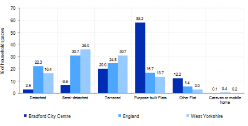
5.1.27 According to census data, Bradford City Centre has over 1,970 dwellings of which only 16.4%, are owner occupied, which is significantly below the West Yorkshire average of 63.4%, the majority being private rented. In terms of housing type, Bradford has a much higher percentage of flats at 58.2% compared to the West Yorkshire average at 13.7% or indeed the national average at 16.7%. Further information on dwelling types is detailed below in Figure 5.
Figure 5: Bradford – Housing Type
5.1.28 The average house price for Bradford is £69,662, which is far lower than the than the West Yorkshire average of £183,194.
5.1.29 Figures suggest that the population density for the City Centre (30.6 persons per hectare) is well over double that of West Yorkshire as a whole (11.4), with a higher percentage of overcrowded housing and vacant dwellings than the West Yorkshire averages. Whilst the City Centre population has increased in recent years given the delivery of numerous flats from new and existing buildings, the delivery of a further significant increase in new homes in the City Centre is a key part of the overall development strategy for Bradford. It will ensure that the housing needs and aspirations of local people can be met, together with those of future residents, through the provision of both market and affordable housing. In addition, it will support the economic and regeneration aspirations for the city centre as well as its position as a Regional City.
5.1.30 Policy SP8 in the local plan sets out a requirement of 7,000 dwellings that will be delivered in the city centre during the plan period. These will be delivered through a mix of committed sites (those under construction or have planning permission but have not yet commenced) and allocations. Table 2 below sets out the housing position for the city centre, which also includes the application of non-implementation or discount rates for planning permissions and allocations.
Table 2: City Centre - Summary of Housing Requirement and Supply
|
Housing Target |
7,000 units |
|
Carried Forward Commitments |
1,241 |
|
Commitment Discounted by 10% |
1,117 |
|
Remaining Allocation Requirement |
5,883 |
|
Identified Allocations |
3,893 |
|
Allocations Discounted by 10% |
3,504 |
|
Total Supply Contribution from Allocations |
3,504 |
5.1.31 Once the commitments are discounted and removed from the supply this leaves a residual allocation requirement of 5,883 units. The evaluated total site supply of housing units from preferred allocation sites equates to 3,893 units which is in turn discounted by 10% for non-implementation or reduced delivery leaving a final allocation contribution of 3,504 units across all sites, which is below the remaining allocation requirement (5,883). To counter this a new Southern Gateway has been identified as a 'broad location for growth' with an additional anticipated supply of 2,500 dwellings. It is anticipated that the area will see major transformational change and an uplift in values following delivery of major infrastructure, including a potential new city centre NPR station within or close to this area. This will in turn facilitate changes in current land uses as part of the long term regeneration of the area.
5.1.32 The area does not currently include specific identified sites to meet the residual target in line with NPPF paragraph 67, as delivery is anticipated towards the end of the plan period following delivery of major infrastructure in this area. Specific sites within this area will be identified as part of any Local Plan review underpinned by relevant and up-to-date evidence.
5.1.33 The city centre is not constrained by Green Belt. The sites within the city centre have been identified as preferred housing site allocations to meet the city centre's housing requirement and have the potential to support a range of housing types including flats, conversions and higher density urban houses. Table B sets out the preferred option housing sites and these are also identified on the Policies Map and the Site Pro formas together with the local strategies map for each plan area.
5.1.34 The development of site allocations should be in accordance with specified development guidelines and approximate minimum site provision figures and all other relevant policies of this Local Plan.
Planning for Places and Communities
Historic Character
5.1.35 Bradford, was first a settlement in Saxon times and by the middle ages had become a small settlement centred on what are now Kirkgate, Westgate and Ivegate, at the junction of three valleys in the basin of the River Aire. The city centre enjoys a substantial, high quality Victorian architectural heritage where the Victorian buildings of Bradford City Centre stand as testament to the city's former affluence and industrial heritage. In some areas such as above Market Street and Little Germany the historic urban fabric remains.
5.1.36 Bradford City Centre possesses a wealth of built heritage from its Victorian heyday, much of which remains intact today. The city centre contains many important historic buildings and spaces. These make a considerable contribution to the character, quality and appearance of large parts of the City Centre. The city centre includes four conservation areas (The City Centre, Goitside, Little Germany and Cathedral Precinct).
5.1.37 There are a total of 276 Listed Buildings within the city centre, the majority of which (264) are Grade II Listed. There are three Grade I Listed Buildings (Bradford Cathedral, The Wool Exchange and Bradford City Hall) and nine Grade II* Listed.
5.1.38 The City Centre was the subject of a Townscape Heritage Initiative (THI), funded by a £2 million grant from the Heritage Lottery Fund and Bradford Council. The Council has worked actively with Historic England to introduce the UK's first Local Listed Building Consents Order for the Little Germany Conservation Area.
Green Infrastructure, Ecology, Open Space and Flood Risk
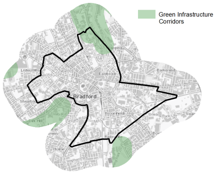
5.1.39 Despite being heavily urbanised the city centre has a range of corridors and spaces that contribute towards its Green and Blue Infrastructure. These corridors and open areas contribute towards the areas Green and Blue Infrastructure networks that form part of the District's Green Infrastructure network and should be protected and enhanced. These areas are multi-functional in nature and help to deliver benefits for biodiversity, reduce flood risk, provide public rights of way, and areas of open space.
5.1.40 Key blue corridors, include the route of the Bradford Beck through the city centre (although much of this route is culverted) Green corridors on the whole do not extend into the city centre but there are a number key open civic spaces, areas of street trees and small landscaped areas of public realm. The Council undertook a Green Infrastructure (GI) Study to assess the existing and future potential of green infrastructure within the City Centre. The GI Study (2014) puts forward a number of Key Green Infrastructure Interventions to improve the ecology of the city centre. These focus around the theme of 'Greening the Grey' and cover 5 Key Interventions including green streets and gateways, habitat highways, green roofs and walls and blue green links.
GI corridors of importance into and on the fringes of the city are shown in figure 6 below.
Figure 6: Green Infrastructure Corridors
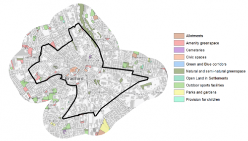
5.1.41 There are 15 sites identified as open space covering an area of around 8ha. The key sites within the City Centre are
- City Park Centenary Square and
- Bradford University Campus.
5.1.42 There is a notable deficit in open space provision in the city and also an imbalance between the different typologies of open space that currently exist. In terms of the distribution of spaces across the settlement area the figure 7 shows that there are large parts of the City Centre where there is no provision of open space. Additional provision should focus on the typologies with the highest deficiencies which are Outdoor Sports, Parks and Gardens and Provision for Children sites. The City Centre would benefit from the additional provision of these types of open space.
Figure 7: Bradford - Open Space Overview
5.1.43 Bradford's location means that parts of the city centre are at risk of fluvial flooding from the Bradford Beck and Eastbrook. Due to the surrounding topography and extensive urbanisation of the city centre, there are also areas which suffer from surface water flooding issues. In particular, there are areas of high fluvial and surface water flood risk, particularly along the northern entrance to the city centre along Valley Road and associated Bradford Beck corridor, and South of the city centre around Nelson Street and Britannia Street.
Community Infrastructure – Education, Health and Utilities
5.1.44 Bradford has a wide range of community and civic facilities to meet the needs of local people. These include post offices, market, places of worship, health and community centres, courts, a library and education facilities.
5.1.45 The City Centre is served by 1 primary school (Rainbow Primary School). There are no secondary schools within the city centre itself. The City Centre is however well catered for in terms of further education. Students have the opportunity to access post 16 education at Bradford College and New College Bradford, which is located in the Southern Gateway near the Interchange. Higher education is available at the University of Bradford.
5.1.46 Pupils attainment levels at Key Stage 4 (GCSE) is below the West Yorkshire and national (England) average scores – 328 compare to 353.5 and 366.3 respectively.
5.1.47 The city has a number of NHS registered healthcare facilities within the centre. Secondary (acute) healthcare is provided at Bradford Royal Infirmary, around 3km to the north west and St Luke's Hospital around 1km to the South West. Average life expectancy at birth is 74 for men and 79 for women, which is marginally below the West Yorkshire and England average. However, healthy life expectancy is only 52 years for men and 50 for women, is well below the national and regional averages.
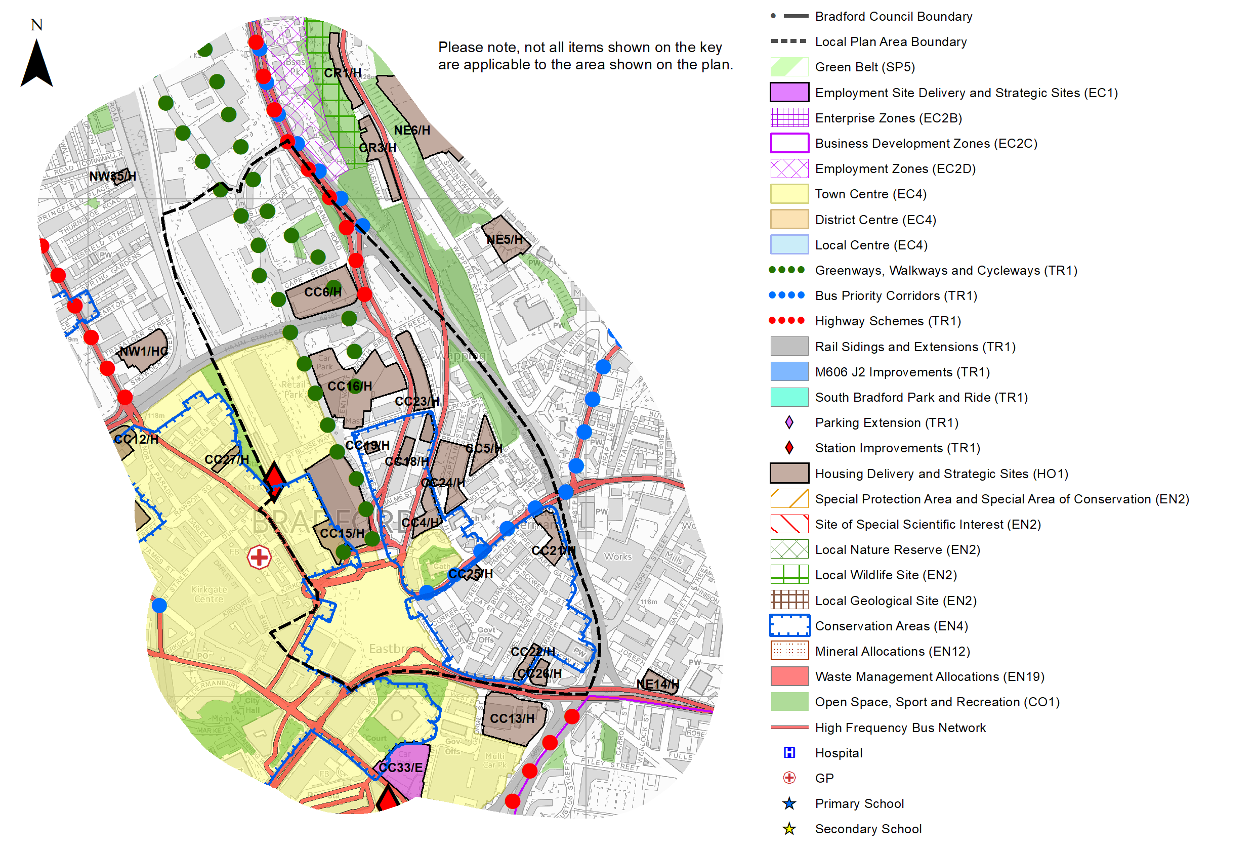
Figure 8: Location of schools and medical facilities in and on the edge of the city centre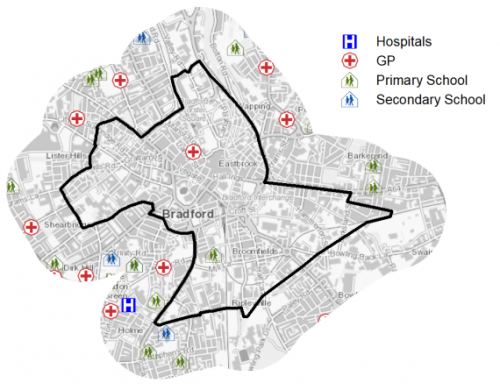
5.1.48 When planning for the long-term development of the City Centre, it is vital that new development is supported by the appropriate infrastructure. The capacity, quality and accessibility of services and facilities are all key components in ensuring people can enjoy living, working and visiting the area. The Council will continue work with key infrastructure providers and others including the Local Education Authority, Clinical Commissioning Group and utilities providers to determine the impacts of future growth and development on local infrastructure capacity and provision. Further infrastructure details will be published through the Local Infrastructure Plan and as part of the Regulation 19 stage of the local plan.
Local Area Strategies
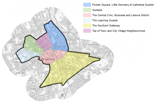
5.1.49 This section of the plan breaks down the city centre into a series of local neighbourhood areas with supporting spatial strategies. It builds upon earlier section information to provide further context and directions for growth.
Figure 9: Bradford City Centre Local Strategy Areas
|
Local Area Strategy and Plan - The Central Civic, Business and Leisure District (CCBL) |
|
The Central Civic, Business and Leisure Districtarea covers the Victorian commercial core of Bradford and embraces many of the city centre's most historically and architecturally important buildings, such as the Wool Exchange, City Hall, former Bradford Odeon, St George's Halland the Alhambra. The award winning City Park has created a high quality, successful focus for the city centre. This area will be a key a location for civic, business and leisure uses and as part of the growth and regeneration of the area as an employment and leisure led quarter of the City Centre, an exemplar for new Grade A office space and business innovation. This will include:
|
|
Local Area Strategy and Plan - Forster Square, Little Germany and Cathedral Quarter (FLC) |
|
Little Germany is a fine example of a 19th century merchant's quarter. There are two Conservation Areas in the neighbourhood – Little Germany and the Cathedral Quarter, which climb up the hillside often to quite dramatic effect and give the area a distinctive character. The Cathedral Precinct Conservation Area incorporates the ecclesiastical buildings that sit on a piece of rising ground to the east of the city and the impressive collection of warehouses below. There are many key historic buildings in the area, including the Cathedral Church of St Peter. The northern part of the neighbourhood around Forster Square station is characterised by low density retail developments, vacant sites and surface car parks, which detract from the quality of the historic Midland Mills and Conditioning House and the gateway to the city centre. The new Broadway Shopping Centre has stimulated development activity and introduced more life and activity and a better urban form to this area. Key strategic growth directions include:
|
|
Local Area Strategy and Plan - Top of Town - City Village Neighbourhood |
|
The Neighbourhood covers much of the historic commercial and retail core of the City Centre, and thus contains a wealth of historic buildings and urban form. The retail core of the area is a pedestrianised zone and is mostly easy to walk around but has been impacted by the opening of the Broadway Centre. Traffic on Westgate and Manor Row and other internal streets however create unpleasant walking environments, and confine and isolate the pedestrian zone and existing squares in the area are not attractive. The majority of The Top of Town - City Village Neighbourhood is part of the 'City Centre Conservation Area'. The tallest building in the neighbourhood Highpoint is one of its most visible. Key strategic growth directions include:
|

|
Local Area Strategy and Plan - Goitside |
|
The Goitside area of Bradford was traditionally the industrial centre of the city. With the steady decline of the wool and manufacturing industries, many of the former mills and warehouses are either vacant/under-occupied or have been converted to small units aimed at students. The further conversion of these remaining buildings to residential units and development of new high quality buildings will not only supply much needed homes but also continue the regeneration of this former industrial hub. The area north of Thornton Road is covered by the Goitside Conservation Area. This area evolved drastically since the Industrial revolution and contains an abundance of historic industrial mill, warehouse and other industrial buildings along principle roads which are now traffic dominated and difficult for pedestrians to cross. Many of the pedestrian routes through the area are full of character with stairways, alleyways and setted surfaces. However, these routes are not as clear, safe or accessible as they could be and there is currently little public nor natural assets. Key strategic growth directions include:
|
|
Local Area Strategy and Plan - The Learning Quarter |
|
In recent years, the University and College campuses have expanded significantly and continually improved the standard of facilities on offer. This expansion has seen an increase in student members and resulted in a massive increase in quantity and quality of the student living offer to meet this demand in particular at The Green where new innovative and contemporary architecture included the use of green technology. The learning quarter however feels relatively isolated from the wider city centre with limited visual and physical links, particularly to Thornton Road Key strategic growth directions include:
|
|
Local Area Strategy and Plan - The Southern Gateway |
|
The Southern Gateway is currently an industrial area south of the city centre. It does not have a strong character and is a rather ad-hoc mix of light industrial units, vacant and underused sites and buildings and large areas of surface car parking. It does however contain some existing residential development, the city police station, the Rainbow Primary School and the new sixth form college. Croft Street creates a major obstacle for pedestrians. The area is located between major road connections and intersections and has the railway line running through the centre. Connections are poor, both internally within the neighbourhood and in terms of its links to its surroundings and the wider city centre. The quality of the public realm, does not create an environment that would encourage people to walk or cycle. The traditional industrial sector is experiencing change and with the delivery of community focussed developments and major plans for a future city centre NPR station the area will transform into an area that will provide new business opportunities and an environment for sustainable urban living. Given the potential for strategic infrastructure investment (NPR and MRT) this area has been designated as a strategic 'broad location for growth' which will look to accommodate around 2,500 new homes, business, commercial and community uses together with supporting infrastructure. With new strategic public transport infrastructure being delivered in this areas through the NPR and MRT programmes, there is ample opportunity for developments to be clustered around these interchange stations, offering density through transit-oriented development. Key strategic growth directions include:
|
(1) Consultation Question 68
Local Area Strategy and Plan - The Central Civic, Business and Leisure District
Q. Please provide any comments you may have on the area strategy?
If you have an alternative to the approaches undertaken, please provide further details and evidence in support.
(2) Consultation Question 69
Local Area Strategy and Plan - Foster Square, Little Germany and Cathedral Quarter
Q. Please provide any comments you may have on the area strategy?
If you have an alternative to the approaches undertaken, please provide further details and evidence in support.
(2) Consultation Question 70
Local Area Strategy and Plan - Top of Town- City Village Neighbourhood
Q. Please provide any comments you may have on the area strategy?
If you have an alternative to the approaches undertaken, please provide further details and evidence in support.
(2) Consultation Question 71
Local Area Strategy and Plan - Goitside
Q. Please provide any comments you may have on the area strategy?
If you have an alternative to the approaches undertaken, please provide further details and evidence in support.
(1) Consultation Question 72
Local Area Strategy and Plan - The Learning Quarter
Q. Please provide any comments you may have on the area strategy?
If you have an alternative to the approaches undertaken, please provide further details and evidence in support.
(2) Consultation Question 73
Local Area Strategy and Plan - The Southern Gateway
Q. Please provide any comments you may have on the area strategy?
If you have an alternative to the approaches undertaken, please provide further details and evidence in support.
Preferred Site Allocations and Site Pro Formas
5.1.50 The preferred site allocations for Bradford City Centre for both commercial and housing are detailed below in Tables A and B. These tables are subsequently followed by site pro formas for each preferred site allocation proving a summary of key site information and characteristics.
Table A: Bradford City Centre Commercial Sites - Preferred Allocations
|
Site Ref |
Site Name |
Type |
Site Area (Gross Hectares) |
Local Area |
|
CC31/E |
Prince's Way |
Mixed |
0.4 |
CCBL |
|
CC32/E |
Former Jacobs Well, Nelson Street |
Brownfield |
1.01 |
CCBL |
|
CC33/E |
Vicar Lane |
Brownfield |
0.86 |
CCBL |
|
Total |
2.27ha |
Table B: City Centre Housing & Mixed Use Sites - Preferred Allocations
|
Site Ref |
Site Name |
Dwellings / Other Uses |
Local Area |
|
CC1/H |
Fulton Street/Sunbridge Rd |
100 |
Goitside |
|
CC2/H |
Former Bee Hive Mills, Smith Street |
200 |
Goitside |
|
CC3/H |
Listerhills Road |
250 |
Goitside |
|
CC4/H |
Cathedral Quarter B |
50 |
FLC |
|
CC5/H |
Sun Street |
60 |
FLC |
|
CC6/H |
Midland Mills, Valley Road |
200 |
FLC |
|
CC7/H |
Thornton Rd south |
300 |
Goitside |
|
CC8/H |
179 Sunbridge Rd |
50 |
Goitside |
|
CC9/H |
Tetley Street |
100 |
Top of Town |
|
CC10/H |
Land and buildings south of Sunbridge Rd |
75 |
Goitside |
|
CC11/H |
Wigan Street |
120 |
Goitside |
|
CC12/H |
Top of Town, City Village |
500 |
Top of Town |
|
CC13/H |
George Street B |
200 |
CCBL |
|
CC14/H |
Thornton Road/Water Lane |
40 |
Goitside |
|
CC15/H |
Area West of Valley Rd |
300 |
FLC |
|
CC16/H |
North Brook Street/Valley Rd |
300 |
FLC |
|
CC17/H |
Highpoint |
87 |
Top of Town |
|
CC18/H |
Buildings on Canal Road and Bolton Road |
154 |
FLC |
|
CC19/H |
16-18 Mill Street |
27 |
FLC |
|
CC20/H |
Thornton Rd north |
80 |
Goitside |
|
CC21/H |
Burnett Street Car Park |
60 |
FLC |
|
CC22/H |
East Parade |
50 |
FLC |
|
CC23/H |
Land West of Wharf Street |
100 |
FLC |
|
CC24/H |
Cathedral Quarter A |
90 |
FLC |
|
CC25/H |
Land rear of Cathedral House |
20 |
FLC |
|
CC26/H |
Gate Haus 2 |
20 |
FLC |
|
CC27/H |
Stone Street |
20 |
Top of Town |
|
CC28/H |
Land and buildings east of Grattan Rd |
80 |
Goitside |
|
CC29/H |
Former college Old Building, Great Horton Road |
190 |
Learning Quarter |
|
CC30/H |
496 Leeds Road |
70 |
Southern Gateway |
|
Total |
3893 |
Note: Some sites have received planning approval since 1ST April 2020
(5) Consultation Question 74
Bradford City Centre Site Allocations and Site Pro Formas
The Local Plan sets out a series of preferred site allocations. If you wish to make representations on any of the sites proposed, please provide site reference and feedback under this question. If you wish to propose an additional or alternative site(s) to the preferred allocations listed, please also provide a plan with a red line and any further details in support.
(4) CC31/E - Prince's Way / One City Park
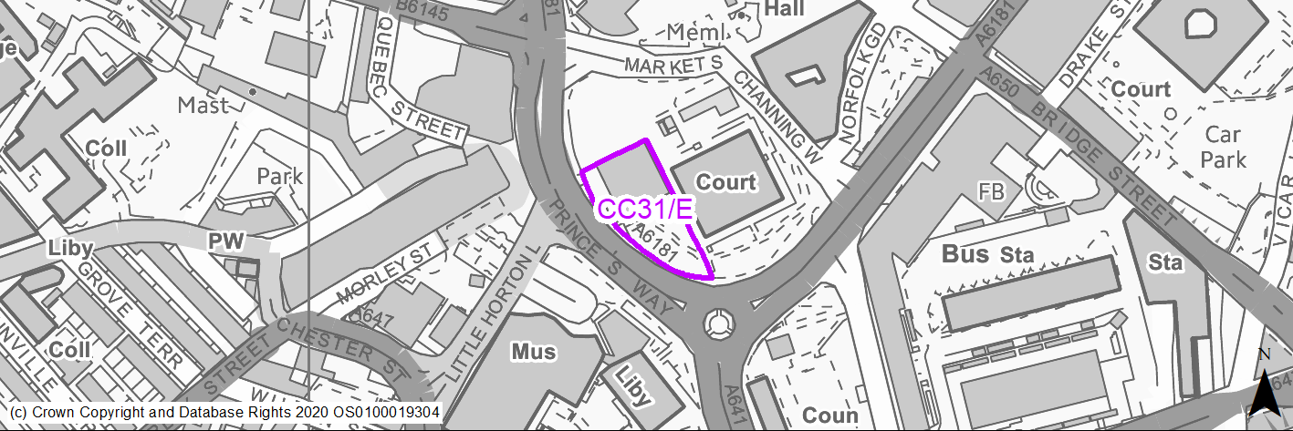
Site location
Regional City - Bradford City Centre
Ward
City
Site description
Prime city centre brownfield regeneration site.
Proposed Allocation
Mixed Use
SHLAA referencce
N/A
Indicative no. dwellings
N/A
Site area (Gross) (ha)
1.3
Ownership
Public
Delivery timescales
2020-25
Type (PDL/Greenfield)
Brownfield - 100%
Green Belt
No
Flood Zone
Flood Zone 1 - low risk of flooding.
Potential site access
City Centre site - There are two existing accesses to the site from Princes Way and from Hall Ings via a ramp leading to a basement car park. The access from Hall Ings would be acceptable for the redevelopment. Any access from Princes Way would be unacceptable and the existing access would need to be closed with full face kerbing and the footway reinstated.
Public Transport Accessibility
Bus Stop within 400m Frequent service / Within 800m of Rail Station
Sustainability Appraisal
Site has been subject to a recent Sustainability Appraisal (SA) as part of the Area Action Plan process, for additional appraisal commentary please see the site reference within the Sustainability Appraisal accompanying the Local Plan.
Habitats Regulations Assessment
This site is beyond the zones of influence of the South Pennine Moors SPA/SAC and is therefore unlikely to have any significant effects, a HRA is not required.
Green Belt
N/A – Site not within the Green Belt.
Constraints and Opportunities
• Carry forward City Centre AAP commercial site.
• The site is located within the City Centre Conservation Area.
• Site identified as part of the GI opportunity corridors.
• Close proximity to Grade 1 listed City Hall.
• Part of this site may contain pockets of important and significant archaeological remains from the postmedieval period to the 18th century, depending upon whether new build on a different footprint to the existing building is envisaged.
Development considerations
• Prime anchor site / location which will require a high quality design solution.
• The public realm should be designed as an extension of city park with the buildings set within the landscape. The design of the proposed office development will be expected to comply to BREEAM ‘Excellent’, where viable and feasible to do so.
• The proposed office development within the No.1 City Park will be of high- quality contextual design that responds sensitively to its setting adjacent to the Grade I Listed City Hall and its location within the City Centre Conservation Area. The height of any buildings will not compromise the dominance of the City Hall buildings or harm key views and vistas of the building. Where possible, opportunities should be taken to open up new views of the City Hall.
• Pedestrian connectivity through the site and links to wider public realm.
• Public realm, open space and GI strategy.
• The buildings should respond to the setting of City Park in terms of their scale and appearance, and they should interact with it at ground floor level with active uses such as restaurants and cafes.
• Developer appointed.
Conclusion/Summary
Prime city centre site which presents an opportunity to deliver commercial and office space of a high quality. Wider public realm and integration strategy required as part of city masterplanning.
Use Class
Class E
(2) CC32/E - Former Jacobs Well, Nelson Street
Site location
Regional City - Bradford City Centre
Ward
City
Site description
Prime city centre brownfield regeneration site.
Proposed Allocation
Mixed Use
SHLAA referencce
N/A
Indicative no. dwellings
N/A
Site area (Gross) (ha)
1.1
Ownership
Public
Delivery timescales
2025-30
Type (PDL/Greenfield)
Brownfield - 100%
Green Belt
No
Flood Zone
Primarily Flood Zone 1 - low risk of flooding - Area of Flood Zone 2 to south eastern edge (13%).
Potential site access
The site is currently accessed off Nelson Street close to its junction with the A641 Croft Street and the Interchange access. Consequently there are conflicting vehicular manoeuvres close to a major signalised junction with adverse impact on pedestrians and public transport. The proposal provides an opportunity to move the site access further north on Nelson Street thereby minimising conflicting traffic manoeuvres at the signal junction. This would also provide a better access to any proposed under croft car parking due to the level difference between the site and Nelson Street at this location.
Public Transport Accessibility
Bus Stop within 400m Frequent service / Within 800m of Rail Station
Sustainability Appraisal
Site has been subject to a recent Sustainability Appraisal (SA) as part of the Area Action Plan process, for additional appraisal commentary please see the site reference within the Sustainability Appraisal accompanying the Local Plan.
Habitats Regulations Assessment
This site is beyond the zones of influence of the South Pennine Moors SPA/SAC and is therefore unlikely to have any significant effects, a HRA is not required.
Green Belt
N/A – Site not within the Green Belt.
Constraints and Opportunities
• Carry forward City Centre AAP commercial site.
• Site identified as part of the GI opportunity corridors.
Development considerations
• The site is surrounded by prominent streets on all four sides and the buildings will need to respond positively to all these, in terms of defining the edge of the streets, animating them at ground floor level, and providing visual interest.
• Active uses should be located on the key pedestrian routes at ground level, particularly Nelson Street.
• The scale of the development should be appropriate in relation to surrounding buildings and the enclosure of the street space but it should not detract from views of City Hall.
• Public realm, open space and GI strategy.
Conclusion/Summary
Prime city centre site which presents an opportunity to deliver commercial and office space of a high quality. Wider public realm and integration strategy required as part of city masterplanning.
Use Class
Class E
(2) CC33/E - Exchange Court / Vicar Lane
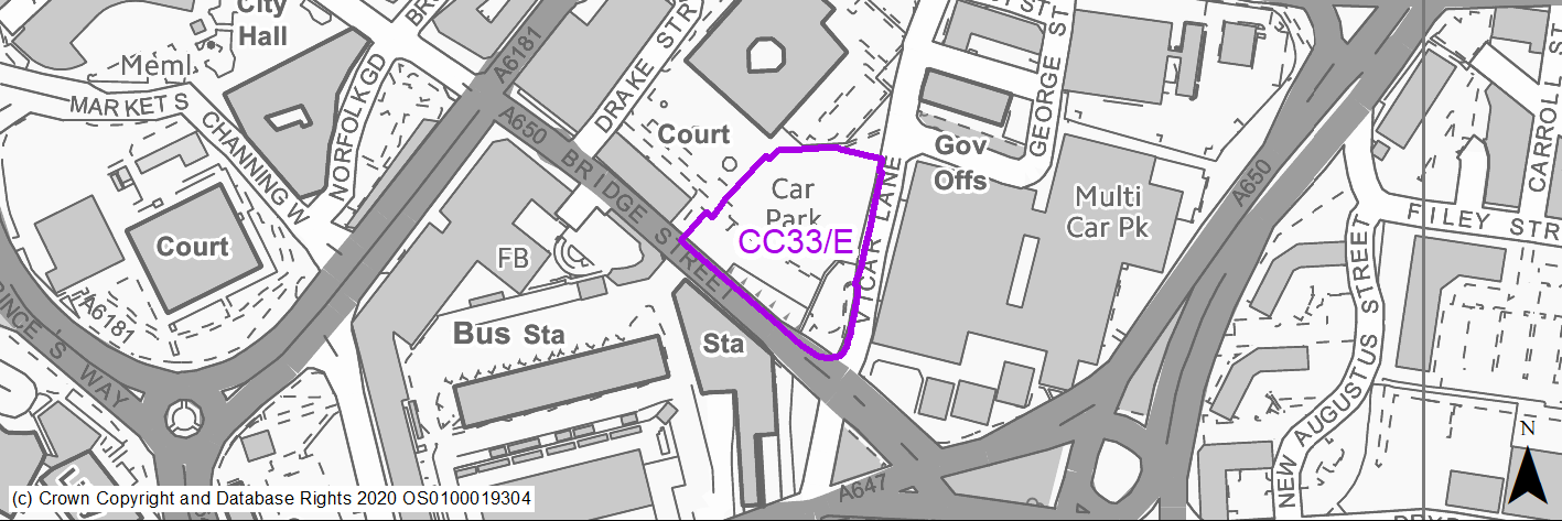
Site location
Regional City - Bradford City Centre
Ward
City
Site description
Prime city centre brownfield regeneration site.
Proposed Allocation
Mixed Use
SHLAA referencce
N/A
Indicative no. dwellings
N/A
Site area (Gross) (ha)
0.68
Ownership
Public
Delivery timescales
2030-35
Type (PDL/Greenfield)
Brownfield - 100%
Green Belt
No
Flood Zone
Flood Zone 1 - low risk of flooding.
Potential site access
While the existing site access at Vicar Lane already serves a large car park and therefore should be acceptable, there is some concern as visibility in the critical direction to the right when emerging from the site is poor and there is no footway across the site frontage on Vicar Lane.
Public Transport Accessibility
Bus Stop within 400m Frequent service / Within 800m of Rail Station
Sustainability Appraisal
Site has been subject to a recent Sustainability Appraisal (SA) as part of the Area Action Plan process, for additional appraisal commentary please see the site reference within the Sustainability Appraisal accompanying the Local Plan.
Habitats Regulations Assessment
This site is beyond the zones of influence of the South Pennine Moors SPA/SAC and is therefore unlikely to have any significant effects, a HRA is not required.
Green Belt
N/A – Site not within the Green Belt.
Constraints and Opportunities
• Carry forward City Centre AAP commercial site.
• Site identified as part of the GI opportunity corridors.
• The site lies within the City Centre Conservation Area and adjacent to the Grade II Listed Victoria Hotel.
Development considerations
• Consideration should be given to how the development of the site could better connect and integrate The Leisure Exchange with the main part of the City Centre.
• Strong building lines and positive frontages should be created to Bridge Street, Exchange Square and Vicar Lane to define and provide visual interest to the streets/public spaces.
• A new area of public realm should be created which provides a setting for the buildings and a pedestrian link between Exchange Square and Vicar Lane.
• Active uses should be provided at ground floor level facing onto Exchange Square.
• The potential of opening the partially built pedestrian route under Bridge Street between the site and the Interchange should be explored.
Conclusion/Summary
Prime city centre site which presents an opportunity to deliver commercial, office and other uses of a high quality. Wider public realm and integration strategy required as part of city masterplanning.
Use Class
Class E
(3) CC1/H - Fulton Street/Sunbridge Road
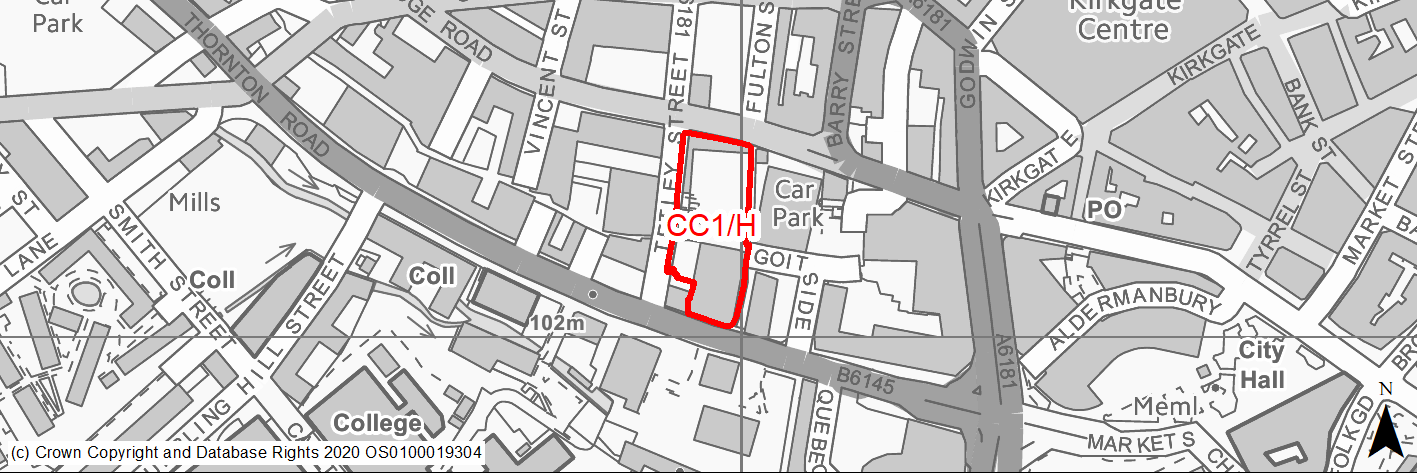
Site location
Regional City of Bradford - City Centre
Ward
City Ward
Site description
The site consited of former mill buildings and warehousing, before being demolished and cleared, and is now a vacant plot.
Proposed Allocation
Housing
SHLAA referencce
CC/001
Indicative no. dwellings
100
Site area (Gross) (ha)
0.5
Ownership
Private
Delivery timescales
Developable (6-11 years)
Type (PDL/Greenfield)
PDL
Green Belt
No
Flood Zone
Flood Zone 1 with small area Flood Zone 2 to the south of the site.
Potential site access
Vehicular access to the site should be provided from Tetley Street. There should be no direct vehicular access from Thornton Road or Sunbridge Road.
Public Transport Accessibility
Site within 400m of a bus stop and 800m of a rail station.
Sustainability Appraisal
Site has been subject to a recent Sustainability Appraisal (SA) as part of the Area Action Plan process, for additional appraisal commentary please see the site reference within the Sustainability Appraisal accompanying the Local Plan.
Habitats Regulations Assessment
This site is beyond the zones of influence of the South Pennine Moors SPA/SAC and is therefore unlikely to have any significant effects, a HRA is not required.
Green Belt
N/A - Site not within the Green Belt.
Constraints and Opportunities
• The site lies within the Goitside Conservation Area and there is a Grade II listed building adjacent to its north-eastern corner.
• The scale and design of new development should respond sensitively to the surrounding historic context and safeguard the character and setting of the adjacent listed building.
• Air quality issues should be assessed and fully mitigated.
• Steep site with significant level differences between the northern and southern boundary.
• Thornton Road to the southern boundary is a significant arterial road into Bradford.
• Prominent site in Goitside where redevelopment presents opportunity to deliver residential development that completes the building line and provides frontages onto the street.
• Opportunity to create public realm around the Goit which runs through the site.
Development considerations
• Development should contribute to improvements to the public realm and pedestrian environment on Thornton Road and Sunbridge Road.
• The site should be developed as two separate city blocks either side of the route of the Goit which flows under the site.
• The Goit would be a new public route and area of public realm, including a new square or courtyard, which could reveal the water flowing underneath by way of decorative grills or transparent surfaces.
• New buildings should respond to the existing scale of buildings in this part of the Goitside and should contribute to the overall character of buildings stepping up the hillside.
• The buildings should repair the building line and provide strong frontages to the streets.
• There could be opportunity to introduce mixed use at ground floor level on Thornton Road and Sunbridge Road and also around the Goitside square/courtyard.
• Development will be required to minimise traffic generation and incorporate a travel plan taking into account the adjacent core public transport, cycling and walking networks.
• Development proposals should be accompanied by a Transport Assessment detailing access and service arrangements and connectivity to the wider highway network.
Conclusion/Summary
The site was previously allocated for residential use in the City Centre AAP (V1.7). This is a sustainably located brownfield site within the settlement boundary which will deliver approximately 100 residential units.
(3) CC2/H - Former Bee Hive Mills, Smith Street
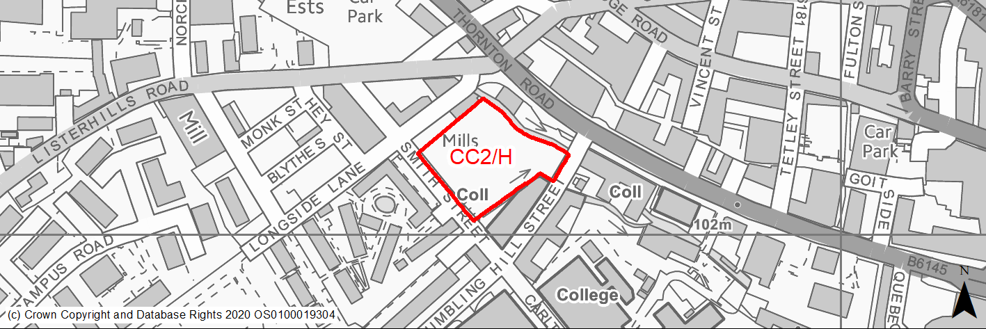
Site location
Regional City of Bradford - City Centre
Ward
City Ward
Site description
The site is currently vacant following the demolition of the former Bee Hive Mills. Site currently part in use as for variety of business uses and part vacant.
Proposed Allocation
Housing
SHLAA referencce
CC/007
Indicative no. dwellings
200
Site area (Gross) (ha)
0.76
Ownership
Private
Delivery timescales
Developable (6-11 years)
Type (PDL/Greenfield)
PDL
Green Belt
No
Flood Zone
Flood Zone 1 and Flood Zone 2 to north of site. Areas of medium/high surface water flood risk within site.
Potential site access
Any vehicular access should be from Tumbling Hill Street and not from Smith Street or Thornton Road.
Public Transport Accessibility
Site within 400m of a bus stop and just beyond 800m of a rail station (Bradford Interchange).
Sustainability Appraisal
Site has been subject to a recent Sustainability Appraisal (SA) as part of the Area Action Plan process, for additional appraisal commentary please see the site reference within the Sustainability Appraisal accompanying the Local Plan.
Habitats Regulations Assessment
This site is beyond the zones of influence of the South Pennine Moors SPA/SAC and is therefore unlikely to have any significant effects, a HRA is not required.
Green Belt
N/A - Site not within the Green Belt.
Constraints and Opportunities
• The site is currently being proposed for a residential allocation, which may include student living as an expansion of the University accommodation.
• The allocation will look for on site provision of convenience retail and leisure use.
• Part of the site is located with Flood Zone 2.
• The site is suitable for a tall building which is high quality and distinctive in terms of its massing, appearance and materials.
• The site is located on the edge of the city centre and therefore the development would be required to minimise traffic generation and incorporate a travel plan taking into account the adjacent core public transport, cycling and walking networks.
Development considerations
• Any planning application on this site must be supported by a site-specific Flood Risk Assessment.
• A new area of public space should be created on the Thornton Road frontage alongside the open watercourse of Bradford Beck, including new trees and soft and hard landscape.
• Active ground floor frontages should be provided facing onto the new area of public space.
• Development proposals should be accompanied by Transport Assessment detailing access and service arrangements and connectivity to the wider highway network.
Conclusion/Summary
Now a slightly smaller site was previously allocated for residential use in the City Centre AAP (V1.6). This is a sustainably located brownfield site within the settlement boundary which will deliver approximately 200 residential units.
(2) CC3/H - Listerhills Road
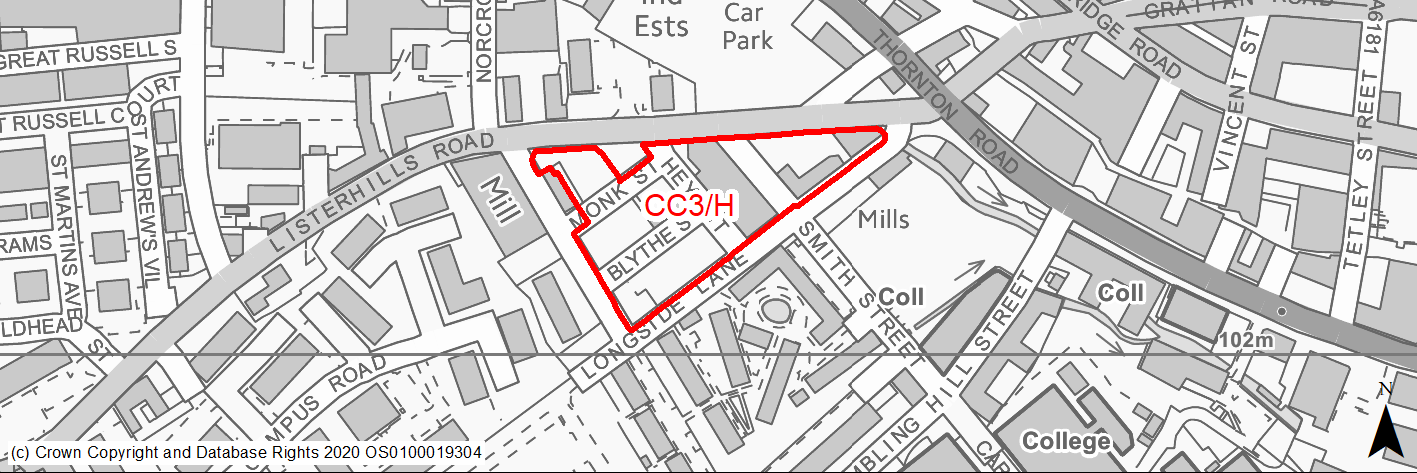
Site location
Regional City of Bradford - City Centre
Ward
City Ward
Site description
The site is currently occupied by a number of industrial / mill units and a surface car park.
Proposed Allocation
Mixed Use
SHLAA referencce
CC/011
Indicative no. dwellings
250
Site area (Gross) (ha)
1.32
Ownership
Private
Delivery timescales
Developable (6-11 years)
Type (PDL/Greenfield)
PDL
Green Belt
No
Flood Zone
Flood Zone 1
Potential site access
Any vehicular access should be from Richmond Road, Longside Lane and Hey Street. There should be no new access from Listerhills Road.
Public Transport Accessibility
Site within 400m of a bus stop and just beyond 800m of a rail station (Bradford Interchange).
Sustainability Appraisal
Site has been subject to a recent Sustainability Appraisal (SA) as part of the Area Action Plan process, for additional appraisal commentary please see the site reference within the Sustainability Appraisal accompanying the Local Plan.
Habitats Regulations Assessment
This site is beyond the zones of influence of the South Pennine Moors SPA/SAC and is therefore unlikely to have any significant effects, a HRA is not required.
Green Belt
N/A - Site not within the Green Belt.
Constraints and Opportunities
• The site is located on the edge of the city centre and therefore the development would be required to minimise traffic generation and incorporate a travel plan taking into account the adjacent core public transport, cycling and walking networks.
• New buildings should respond positively to the surrounding streets and should include a strong feature at the corner of Listerhills Road and Longside Lane.
• The lower part of the site (south of Smith Street) is suitable for tall buildings of high quality, distinctive design.
• The site includes a number of existing industrial buildings some of which make a positive contribution to the character of the area in terms of their layout, scale and appearance. These could be retained and refurbished alongside new infill development. There is scope to reduce parking provision in recognition of the sites accessibility and proximity to public transport facilities.
Development considerations
• The site is suitable for residential led mix use, with ancillary leisure and retail uses.
• Development proposals should be accompanied by Transport Assessment detailing access and service arrangements and connectivity to the wider highway network.
• A pedestrian crossing facility should be provided on Listerhills Road.
Conclusion/Summary
The site was previously allocated for residential use in the City Centre AAP (V1.3). This is a sustainably located brownfield site within the settlement boundary, which will deliver approximately 250 residential units.
(2) CC4/H - Cathedral Quarter B
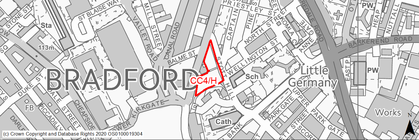
Site location
Regional City of Bradford - City Centre
Ward
City Ward
Site description
The site consists of a mixture of surface car parks, and vacant former primary school.
Proposed Allocation
Housing
SHLAA referencce
CC/018
Indicative no. dwellings
50
Site area (Gross) (ha)
0.3
Ownership
Private
Delivery timescales
Developable (6-11 years)
Type (PDL/Greenfield)
Mixed
Green Belt
No
Flood Zone
Flood Zone 1
Potential site access
Primary vehicular access should be from Bolton Road.
Public Transport Accessibility
Site within 400m of a bus stop and 800m of a rail station.
Sustainability Appraisal
Site has been subject to a recent Sustainability Appraisal (SA) as part of the Area Action Plan process, for additional appraisal commentary please see the site reference within the Sustainability Appraisal accompanying the Local Plan.
Habitats Regulations Assessment
This site is beyond the zones of influence of the South Pennine Moors SPA/SAC and is therefore unlikely to have any significant effects, a HRA is not required.
Green Belt
N/A - Site not within the Green Belt.
Constraints and Opportunities
• Bolton Road is a key route into the city centre and new development should define the edge of the street, be of an appropriate scale and provide active frontages at ground floor level.
• The site is adjacent a Listed Building and lies within the Cathedral Precinct Conservation Area.
Development considerations
• The scale and design of new development should respond sensitively to the surrounding historic context, and safeguard the character and setting of the adjacent Listed Building.
• The site is located in the city centre and therefore the development would be required to minimise traffic generation and incorporate a travel plan taking into account the adjacent core public transport, cycling and walking networks.
Conclusion/Summary
The site was previously allocated for residential use in the City Centre AAP (CH1.3). This is a sustainably located part brownfield site within the settlement boundary, which would deliver an estimated 50 dwellings.
(1) CC5/H - Sun Street
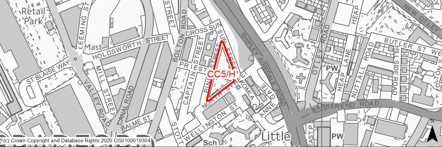
Site location
Regional City of Bradford - City Centre
Ward
City Ward
Site description
The site consists of a mixture of surface car parks.
Proposed Allocation
Housing
SHLAA referencce
CC/020
Indicative no. dwellings
60
Site area (Gross) (ha)
0.33
Ownership
Private
Delivery timescales
Developable (6-11 years)
Type (PDL/Greenfield)
Mixed
Green Belt
No
Flood Zone
Flood Zone 1
Potential site access
Primary vehicular access should be from Sun Street and Pine Street.
Public Transport Accessibility
Site within 400m of a bus stop and just beyond 800m of a rail station (Bradford Interchange).
Sustainability Appraisal
Site has been subject to a recent Sustainability Appraisal (SA) as part of the Area Action Plan process, for additional appraisal commentary please see the site reference within the Sustainability Appraisal accompanying the Local Plan.
Habitats Regulations Assessment
This site is beyond the zones of influence of the South Pennine Moors SPA/SAC and is therefore unlikely to have any significant effects, a HRA is not required.
Green Belt
N/A - Site not within the Green Belt.
Constraints and Opportunities
• The site is located in the city centre and therefore the development would be required to minimise traffic generation and incorporate a travel plan taking into account the adjacent core public transport, cycling and walking networks.
• The layout and scale of the buildings should respond to the sloping nature of the site.
• It is likely that lower buildings (e.g. 3 storeys) will be most appropriate.
• The scale and design of new development should respond sensitively to the surrounding historic context, and safeguard the character and setting of the nearby Listed Buildings
• Explore the potential for new public spaces to be created at corner of Stott Hill and top of North Street.
Development considerations
• Any development should ensure that the tower of the former Bradford College Cathedral Building, to the east of this site remains as a prominent local landmark.
• Development gradients should be a maximum 1 in 15, though 1 in 20 is desirable.
Conclusion/Summary
The site was previously allocated for residential use in the City Centre AAP (CH1.4). This is a sustainably located site within the settlement boundary which will deliver approximately 60 residential units.
(3) CC6/H - Midland Mills, Valley Road
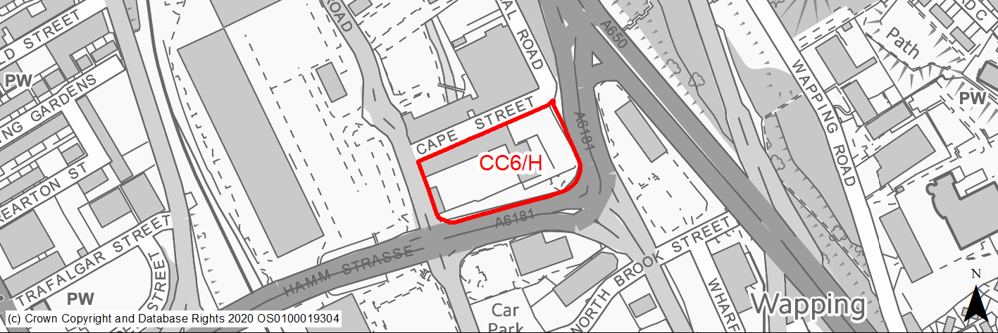
Site location
Regional City of Bradford - City Centre
Ward
City Ward
Site description
The site is located in the upper east side of the city, and contains 3 Grade II listed mill buildings opposite Conditioning House which is currently in the process of being redeveloped to residential.
Proposed Allocation
Housing
SHLAA referencce
CC/022
Indicative no. dwellings
200
Site area (Gross) (ha)
0.95
Ownership
Private
Delivery timescales
Developable (6-11 years)
Type (PDL/Greenfield)
PDL
Green Belt
No
Flood Zone
Flood Zone 2 and Flood Zone 3
Potential site access
Primary vehicular access should be from the existing access point on Valley Road. A second vehicular access from Cape Street/Old Canal Road may also be needed to serve part of the site segregated by the Bradford Canal alignment.
Public Transport Accessibility
Site within 400m of a bus stop and just beyond 800m of a rail station (Bradford Forster Square).
Sustainability Appraisal
Site has been subject to a recent Sustainability Appraisal (SA) as part of the Area Action Plan process, for additional appraisal commentary please see the site reference within the Sustainability Appraisal accompanying the Local Plan.
Habitats Regulations Assessment
This site is beyond the zones of influence of the South Pennine Moors SPA/SAC and is therefore unlikely to have any significant effects, a HRA is not required.
Green Belt
N/A - Site not within the Green Belt.
Constraints and Opportunities
• The site contains 3 Grade II listed mill buildings.
• The site is currently located with Flood Zone 2 and 3a.
• The landscaped verge alongside Hamm Strasse could be retained but remodelled to integrate better with development on the site and provide useable space. This could include improving the pedestrian environment alongside the city centre ring road, possibly introducing new tree planting along the edge of the footway.
• There are opportunities for new buildings of a similar scale to the existing which positively address the edges of the site including Hamm Strasse and Canal Road.
• Car parking could be provided underneath any new buildings.
Development considerations
• The Grade II listed mill will require archaeological recording before conversion.
• Any planning application on this site must be supported by a site-specific Flood Risk Assessment.
• Any development should involve the conversion of the listed mill buildings on site.
• Communal open space for residents should be provided along the proposed route of the canal and also over the line of the Beck.
Conclusion/Summary
The site was previously allocated for residential use in the City Centre AAP (CH1.13). This is a sustainably located mixed site within the settlement boundary which will deliver approximately 200 residential units.
(2) CC7/H - Thornton Road south
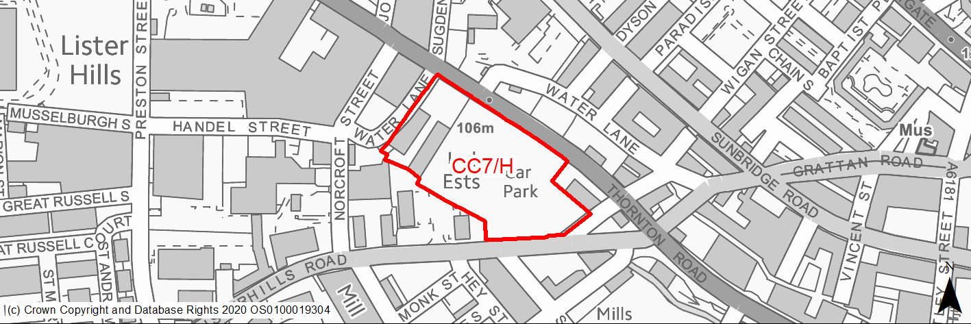
Site location
Regional City of Bradford - City Centre
Ward
City Ward
Site description
The site was previously occupied by the Bradford Gas Works and Listerhills Foundry. Since the decommissioning of the works and demolition of the foundry, the site has operated as a surface car park and car repairs.
Proposed Allocation
Mixed Use
SHLAA referencce
CC/024
Indicative no. dwellings
300
Site area (Gross) (ha)
1.54
Ownership
Private
Delivery timescales
Developable (6-11 years)
Type (PDL/Greenfield)
PDL
Green Belt
No
Flood Zone
Flood Zone 2
Potential site access
The site is bounded by Thornton Road and Listerhills Road and therefore vehicular access should be considered from both of these roads. Access at Thornton Road should be positioned at same location as existing car park access. The location of any access on Listerhills Road will be dependent on achieving a level access as a there is a level difference between the site and Listerhills Road.
Public Transport Accessibility
Site within 400m of a bus stop and just beyond 800m of a rail station (Bradford Forster Square).
Sustainability Appraisal
Site has been subject to a recent Sustainability Appraisal (SA) as part of the Area Action Plan process, for additional appraisal commentary please see the site reference within the Sustainability Appraisal accompanying the Local Plan.
Habitats Regulations Assessment
This site is beyond the zones of influence of the South Pennine Moors SPA/SAC and is therefore unlikely to have any significant effects, a HRA is not required.
Green Belt
N/A - Site not within the Green Belt.
Constraints and Opportunities
• The site is located on the edge of the city centre and therefore the development would be required to minimise traffic generation and incorporate a travel plan taking into account the adjacent core public transport, cycling and walking networks.
• The site is currently located with Flood Zone 2.
Development considerations
• Any redevelopment of the site should create an iconic gateway to the city centre, including a landmark building at the corner of Thornton Road/Listerhills Road.
• The site is suitable for tall buildings of high quality, distinctive design.
• Any development should respond to the aspiration to create a linear green park along the Thornton Road corridor, possibly incorporating water features.
• The buildings should provide positive frontages to the surrounding streets, particularly to Thornton Road and Listerhills Road.
• A Masterplan will be required to establish the design framework and principles for the site.
• Any planning application on this site must be supported by a site-specific Flood Risk Assessment.
• The site is located in the city centre and therefore the development would be required to minimise traffic generation and incorporate a travel plan taking into account the adjacent core public transport, cycling and walking networks.
Conclusion/Summary
The site was previously allocated for residential use in the City Centre AAP (V1.2). This is a slightly larger site, sustainably located where residential led mixed site within the settlement boundary which will deliver approximately 300 residential units.
(2) CC8/H - 179 Sunbridge Road
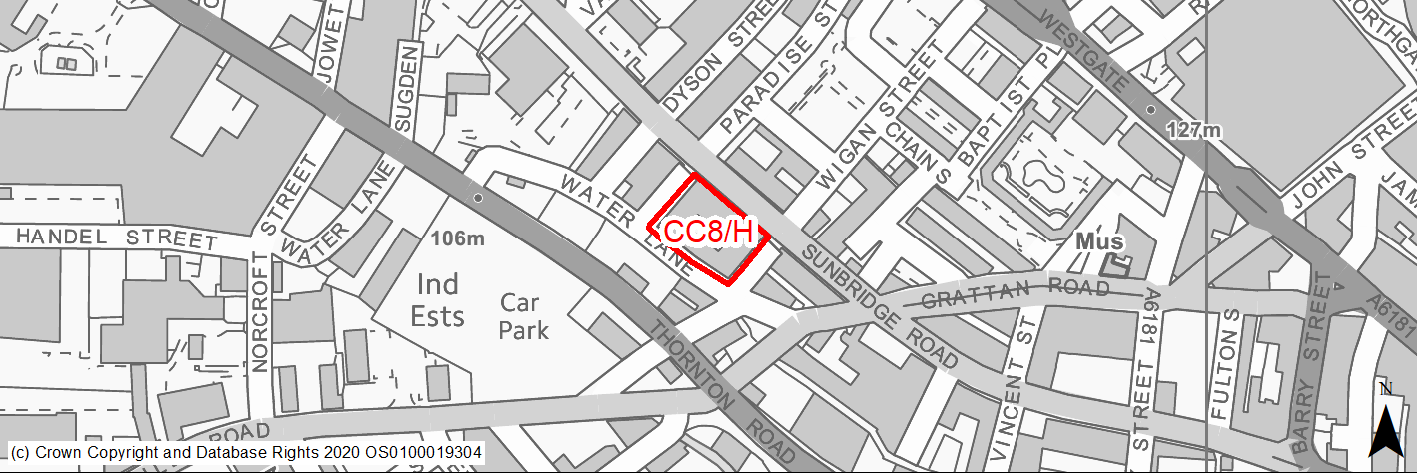
Site location
Regional City of Bradford - City Centre
Ward
City Ward
Site description
The site consists of mostly vacant warehouse and mill buildings located between Sunbridge Road and Water Lane. The site is on a steep gradient.
Proposed Allocation
Housing
SHLAA referencce
CC/025
Indicative no. dwellings
50
Site area (Gross) (ha)
0.27
Ownership
Private
Delivery timescales
Developable (6-11 years)
Type (PDL/Greenfield)
PDL
Green Belt
No
Flood Zone
Flood Zone 1
Potential site access
The site can be accessed from the surrounding road network.
Public Transport Accessibility
Site within 400m of a bus stop and 800m of a rail station (Bradford Forster Square).
Sustainability Appraisal
See individual Sustainability Appraisal site comment in the accompanying report.
Habitats Regulations Assessment
This site is beyond the zones of influence of the South Pennine Moors SPA/SAC and is therefore unlikely to have any significant effects, a HRA is not required.
Green Belt
N/A - Site not within the Green Belt.
Constraints and Opportunities
• The site is located in the Goitside conservation area and is a key unlisted building with heritage value.
• Air quality impacts (Sunbridge Road).
Development considerations
• Any development should involve the retention and conversion of the Laconia building which is of architectural and heritage value and should be retained and converted.
• Any conversion should maintain the traditional features and details of this key unlisted building.
• Development proposals should respond sensitively to the surrounding historic context and safeguard the character and setting of adjacent listed buildings and conservation area.
• Development will be required to minimise traffic generation and incorporate a travel plan taking into account the adjacent core public transport, cycling and walking networks.
Conclusion/Summary
This is a sustainably located brownfield site within the settlement boundary.
(2) CC9/H - Tetley Street
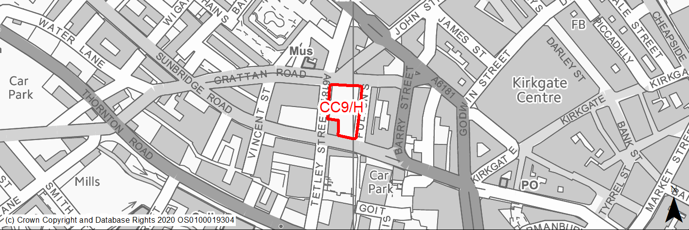
Site location
Regional City of Bradford - City Centre
Ward
City Ward
Site description
The site currently consists of vacant land and a surface car park off Tetley Street. The site slopes upwards from south to north.
Proposed Allocation
Housing
SHLAA referencce
CC/026
Indicative no. dwellings
100
Site area (Gross) (ha)
0.24
Ownership
Private
Delivery timescales
Developable (6-11 years)
Type (PDL/Greenfield)
PDL
Green Belt
No
Flood Zone
Flood Zone 1
Potential site access
There is scope to reduce parking provision in recognition of the sites accessibility and proximity to public transport facilities. Some basement or undercroft parking may be acceptable with access off Fulton Street.
Public Transport Accessibility
Site within 400m of a bus stop and 800m of a rail station (Bradford Interchange).
Sustainability Appraisal
Site has been subject to a recent Sustainability Appraisal (SA) as part of the Area Action Plan process, for additional appraisal commentary please see the site reference within the Sustainability Appraisal accompanying the Local Plan.
Habitats Regulations Assessment
This site is beyond the zones of influence of the South Pennine Moors SPA/SAC and is therefore unlikely to have any significant effects, a HRA is not required.
Green Belt
N/A - Site not within the Green Belt.
Constraints and Opportunities
• The site is located in the Goitside conservation area and the existing key unlisted buildings on site (Sun Hotel) should be retained.
• Opportunity through redevelopment to improve street frontage and associated public realm.
• Significant scale of adjacent building.
• Site identified as part of wider city village masterplan area.
• The site may contain pockets of important and significant archaeological remains from the medieval period to the 18th century.
• Significant level differences across site.
Development considerations
• The two existing key unlisted buildings on the edge of the site – the cottage and The Sun – should be incorporated into any scheme.
• Active ground floor uses should be provided on the Sunbridge Road frontage and also along Grattan Road.
• Development proposals should respond sensitively to the surrounding historic context and safeguard the character and setting of adjacent listed buildings and conservation area.
• The scale and form of new buildings should respond to the existing character of the area, in particular the way the buildings step up the hillside in the Goitside.
Conclusion/Summary
The revised site was previously allocated for residential use in the City Centre AAP (M1.5). This is a sustainably located brownfield site within the settlement boundary which will deliver approximately 100 residential units.
(3) CC10/H - Land and buildings south of Sunbridge Road
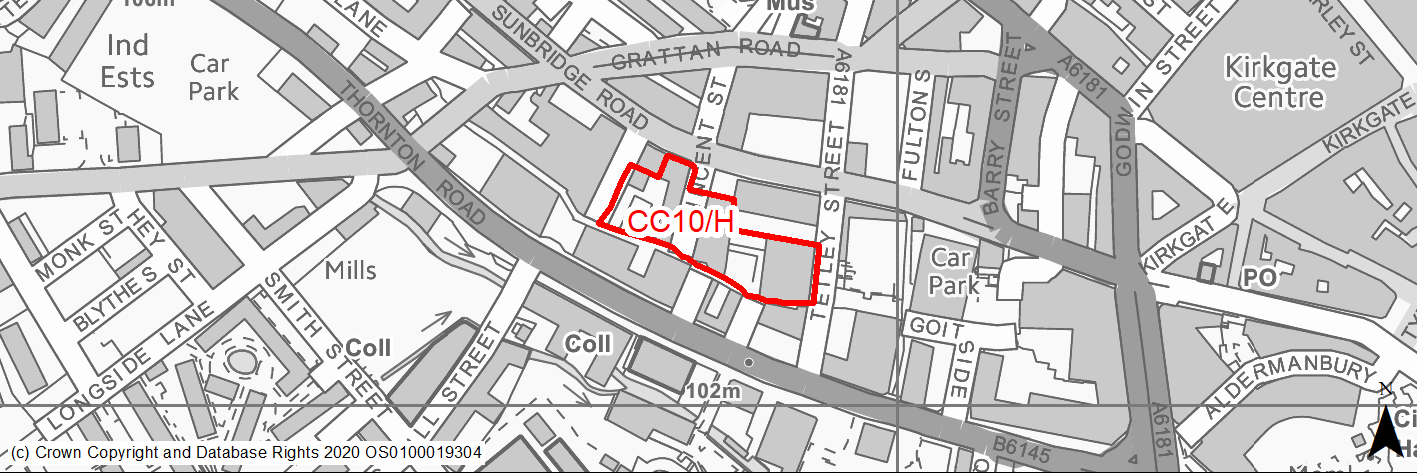
Site location
Regional City of Bradford - City Centre
Ward
City Ward
Site description
The site consists of vacant and underused warehouse and mill buildings located between Sunbridge Road and Vincent Street.
Proposed Allocation
Housing
SHLAA referencce
CC/027
Indicative no. dwellings
75
Site area (Gross) (ha)
0.58
Ownership
Private
Delivery timescales
Developable (6-11 years)
Type (PDL/Greenfield)
PDL
Green Belt
No
Flood Zone
Flood Zone 1
Potential site access
The site can be accessed from the surrounding road network (Sunbridge Road/Vincent Street).
Public Transport Accessibility
Site within 400m of a bus stop and 800m of a rail station (Bradford Forster Square).
Sustainability Appraisal
See individual Sustainability Appraisal site comment in the accompanying report.
Habitats Regulations Assessment
This site is beyond the zones of influence of the South Pennine Moors SPA/SAC and is therefore unlikely to have any significant effects, a HRA is not required.
Green Belt
N/A - Site not within the Green Belt.
Constraints and Opportunities
• The site is located in the Goitside conservation area and adjacent three listed buildings.
• Historic unlisted mill buildings with architectural significance.
Development considerations
• Any development should involve the conversion of the existing mill building.
• Development will be required to minimise traffic generation and incorporate a travel plan taking into account the adjacent core public transport, cycling and walking networks.
Conclusion/Summary
This is a sustainably located brownfield site within the settlement boundary, which will deliver approximately 75 residential units.
(2) CC11/H - Wigan Street
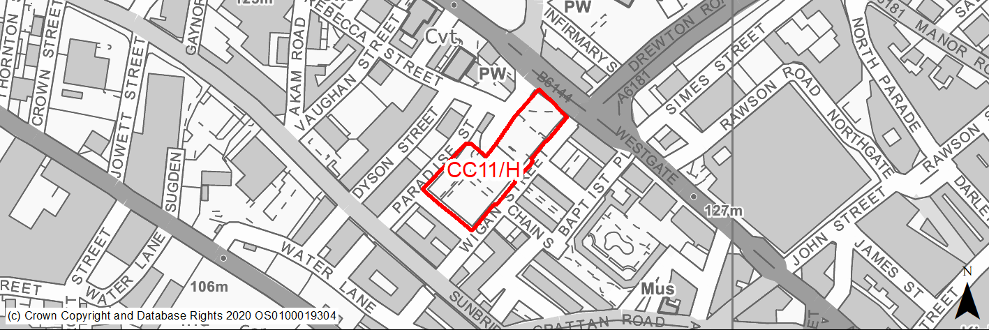
Site location
Regional City of Bradford - City Centre
Ward
City Ward
Site description
The site is currently used as a Council owned surface pay and display car park.
Proposed Allocation
Housing
SHLAA referencce
CC/037
Indicative no. dwellings
120
Site area (Gross) (ha)
0.62
Ownership
Council
Delivery timescales
Developable (6-11 years)
Type (PDL/Greenfield)
PDL
Green Belt
No
Flood Zone
Flood Zone 2
Potential site access
Any vehicular access should be from Wigan Street.
Public Transport Accessibility
Site within 400m of a bus stop and 800m of a rail station (Bradford Forster Square).
Sustainability Appraisal
Site has been subject to a recent Sustainability Appraisal (SA) as part of the Area Action Plan process, for additional appraisal commentary please see the site reference within the Sustainability Appraisal accompanying the Local Plan.
Habitats Regulations Assessment
This site is beyond the zones of influence of the South Pennine Moors SPA/SAC and is therefore unlikely to have any significant effects, a HRA is not required.
Green Belt
N/A - Site not within the Green Belt.
Constraints and Opportunities
• Site immediately adjacent Goitside conservation area.
• Majority of adjacent properties 2-3 storeys.
• Redevelopment provides opportunity to continue improvement to public realm and new high quality high density housing, completed as part of Chain Street development.
• The existing surface car park, serves an important function in this locality and some replacement public parking should be incorporated into the development. This could be achieved through TROs to create short stay on street parking.
Development considerations
• The scale and building line of new development should help to repair the urban fabric of the area, particularly along Westgate, Wigan Street and Paradise Street.
• Active commercial uses should be provided at ground floor level on the Westgate frontage.
• Site is appropriate for 2-3 storey townhouses and small apartment buildings.
• The existing greenspace to east of site provides a landscape buffer to Westgate and should be retained.
Conclusion/Summary
The site was previously allocated for residential use in the City Centre AAP (V1.4). This is a sustainably located brownfield site within the settlement boundary which will deliver approximately 120 residential units.
(4) CC12/H - City Village Top of Town
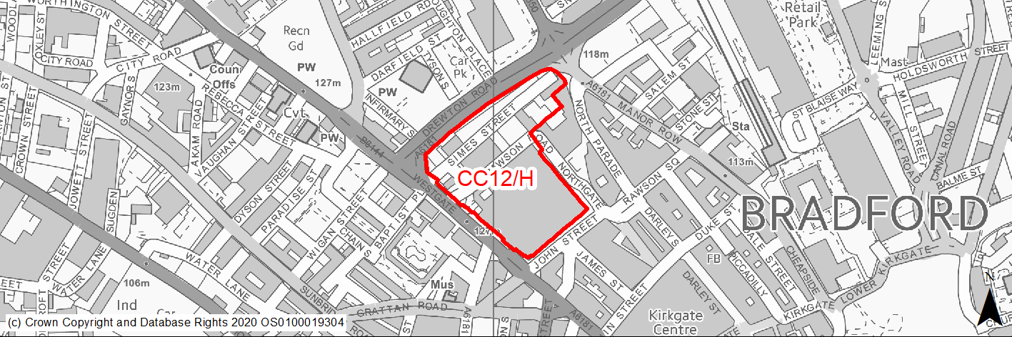
Site location
Regional City of Bradford - City Centre
Ward
City Ward
Site description
The site consists of an enlarged site comprising Simes Street Car Park, a Council owned and surface car park, the Oastler centre and associated multi-storey car park. The site includes the remains of the Grade II Listed Simes Street Chapel (Fountains Hall) and the United Reform Chapel, to the west of this site.
Proposed Allocation
Housing
SHLAA referencce
CC/038
Indicative no. dwellings
500
Site area (Gross) (ha)
2.81
Ownership
Council
Delivery timescales
Developable (6-11 years)
Type (PDL/Greenfield)
PDL
Green Belt
No
Flood Zone
Flood Zone 1
Potential site access
The site can be accessed from the surrounding road network, direct access from Drewton Road would be unacceptable.
Public Transport Accessibility
Site within 400m of a bus stop and 800m of a rail station (Bradford Forster Square).
Sustainability Appraisal
Site has been subject to a recent Sustainability Appraisal (SA) as part of the Area Action Plan process, for additional appraisal commentary please see the site reference within the Sustainability Appraisal accompanying the Local Plan.
Habitats Regulations Assessment
This site is beyond the zones of influence of the South Pennine Moors SPA/SAC and is therefore unlikely to have any significant effects, a HRA is not required.
Green Belt
N/A - Site not within the Green Belt.
Constraints and Opportunities
• Site identified in the City Village Masterplan 'Top of Town Site'.
• Two listed buildings within site boundary. The site includes the remains of the Simes Street Chapel, a Grade II Listed Building. The Reform Chapel, to the west of this site, is also Listed.
• The site is located adjacent the Goitside and the city centre conservation area.
• Air quality noise issues.
• The site has an important frontage to Westgate and new development should help to repair the urban fabric along this route in terms of building line, scale and creating a strong corner feature at the junction with Drewton Road.
• Topography - part of the site slopes significantly from North to South.
• Opportunity for new residential development with mix of apartments and townhouses with some active ground floor commercial uses.
Development considerations
• Any development should retain and enhance the significance of the two listed buildings within the site, the former Simes Street Chapel should be incorporated sensitively into any scheme.
• Some public parking should be incorporated into the development to make up for some of the spaces lost.
• Any new development should create a positive frontage to Drewton Road/Westgate to enhance the quality of this prominent route.
• A Masterplan will be required to establish the design framework and principles for the site.
• The site is located in the city centre and therefore the development would be required to minimise traffic generation and incorporate a travel plan taking into account the adjacent core public transport, cycling and walking networks.
• Active uses should be provided at ground floor level and improvements should be made to the surrounding public realm.
Conclusion/Summary
The site was previously allocated for residential use in the City Centre AAP (M1.1). This is a larger site which is sustainably located site within the settlement boundary which will deliver approximately 500 residential units following the relocation of the market to Darley Street.
(4) CC13/H - George Street B
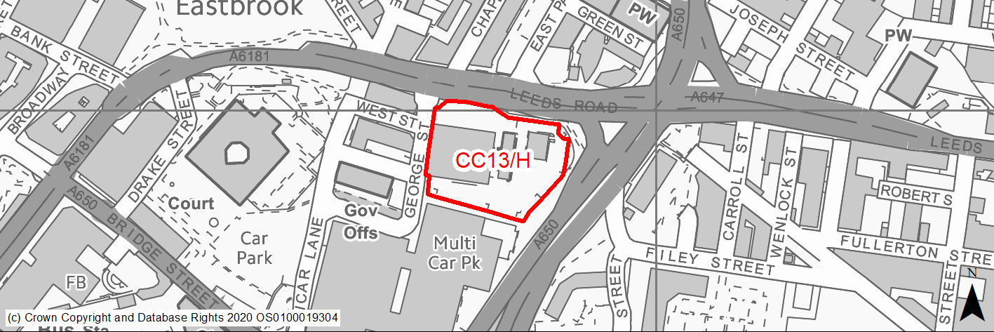
Site location
Regional City of Bradford - City Centre
Ward
City Ward
Site description
Site previously occupied by the former George Street Yorkshire Water Depot and Laboratory currently in use as surface car park.
Proposed Allocation
Mixed Use
SHLAA referencce
CC/039
Indicative no. dwellings
200
Site area (Gross) (ha)
1.19
Ownership
Private
Delivery timescales
Developable (6-11 years)
Type (PDL/Greenfield)
PDL
Green Belt
No
Flood Zone
Flood Zone 1, Flood Zone 2 and Flood Zone 3a.
Potential site access
The site has existing vehicular access from George Street. Direct access from Leeds Road is unlikely to be considered acceptable.
Public Transport Accessibility
Site within 400m of a bus stop and 800m of a rail station (Bradford interchange).
Sustainability Appraisal
Site has been subject to a recent Sustainability Appraisal (SA) as part of the Area Action Plan process, for additional appraisal commentary please see the site reference within the Sustainability Appraisal accompanying the Local Plan.
Habitats Regulations Assessment
This site is beyond the zones of influence of the South Pennine Moors SPA/SAC and is therefore unlikely to have any significant effects, a HRA is not required.
Green Belt
N/A - Site not within the Green Belt.
Constraints and Opportunities
• Air quality issues.
• 77% of the site is currently located with Flood Zone 3a, with the remain 13% being located within Flood Zone 2.
• Areas of medium/high surface water flood risk.
• Improvements to pedestrian and cycle links within and through the site to existing networks at Leeds Road and Shipley Airedale Road would help to connect the development to the surrounding area and encourage walking and cycling.
Development considerations
• Any development should define the edges of the site and be of an appropriate scale in terms of enclosing the surrounding streets and responding to the historic character of the adjacent Little Germany Conservation Area.
• A strong landmark feature should be provided at the corner of Leeds Road and Shipley Airedale Road.
• Active uses should be provided at ground floor level along Leeds Road.
• Improvements should be made to pedestrian provision along Leeds Road and Shipley Airedale Road.
• Development proposals should be accompanied by a Transport Assessment detailing access arrangements. This assessment should specifically include the impact on George Street Vicar Lane one way traffic system and any improvements that may be required.
• A sequential approach to site layout should be followed with the aim of locating the residential units outside of Flood Zone 3a. A further option would be to construct multi-storey occupancy buildings whereby the ground floor is used for non-habitable space such as car parking or a less vulnerable use such as the proposed leisure or retail units.
• Any planning application on this site must be supported by a site specific Flood Risk Assessment.
Conclusion/Summary
The site was previously allocated for mixed use in the City Centre AAP (B1.5). This is a sustainably located brownfield site within the settlement boundary which will deliver approximately 200 residential units.
(2) CC14/H - Thornton Road/Water Lane
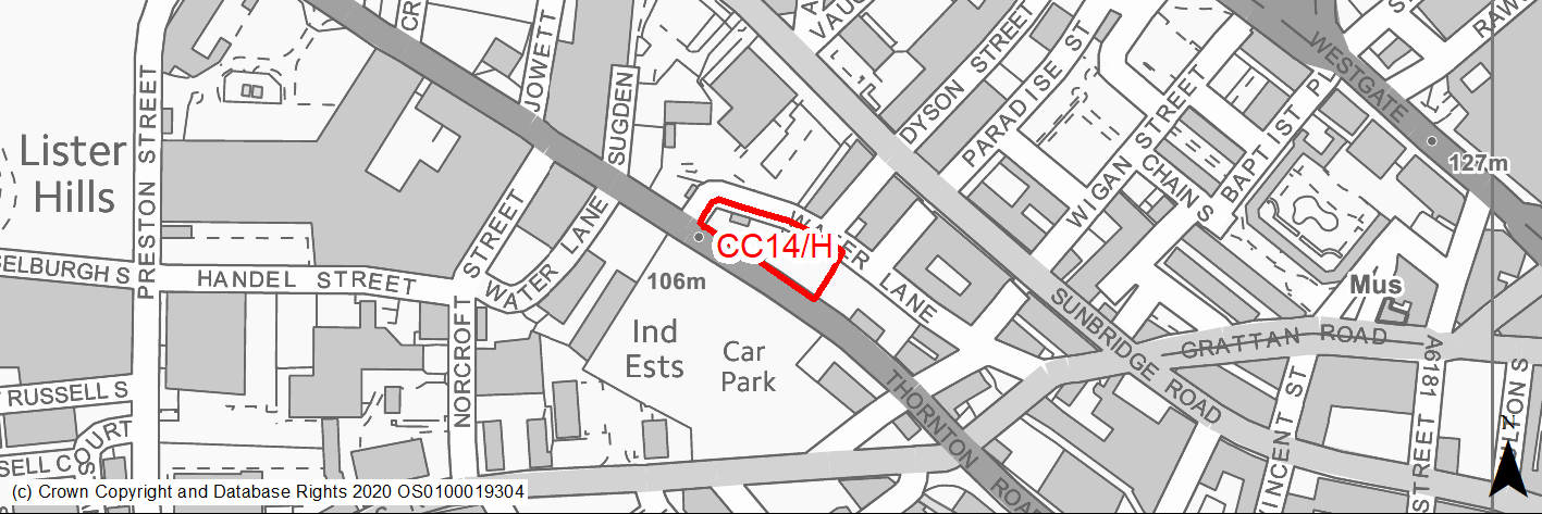
Site location
Regional City of Bradford - City Centre
Ward
City Ward
Site description
Level unused land - reduced to remove operational car wash.
Proposed Allocation
Housing
SHLAA referencce
CC/042
Indicative no. dwellings
40
Site area (Gross) (ha)
0.22
Ownership
Private
Delivery timescales
Developable (6-11 years)
Type (PDL/Greenfield)
PDL
Green Belt
No
Flood Zone
Flood Zone 1 and small area to east Flood Zone 2
Potential site access
The site has existing vehicular access from Thornton Road. Any proposed vehicular access from Water Lane would require the road to be brought up to adoptable standard.
Public Transport Accessibility
Site within 400m of a bus stop and just beyond 800m of a rail station (Bradford Forster Square).
Sustainability Appraisal
Site has been subject to a recent Sustainability Appraisal (SA) as part of the Area Action Plan process, for additional appraisal commentary please see the site reference within the Sustainability Appraisal accompanying the Local Plan.
Habitats Regulations Assessment
This site is beyond the zones of influence of the South Pennine Moors SPA/SAC and is therefore unlikely to have any significant effects, a HRA is not required.
Green Belt
N/A - Site not within the Green Belt.
Constraints and Opportunities
• The site offers the opportunity for a new, sensitively designed tall building.
• The site adjoins the boundary of the Goitside Conservation Area.
Development considerations
• New development should contribute to improving the pedestrian environment along Thornton Road with a new crossing point, footway enhancements and a continuous building line with active frontages at ground floor level.
• TROs may be required to control on-street parking around the site.
• Any redevelopment of this area should respond sensitively to the surrounding historic context.
• Any planning application on this site must be supported by a site-specific Flood Risk Assessment.
Conclusion/Summary
The site was previously allocated for residential use in the City Centre AAP (V1.10). This is a sustainably located site within the settlement boundary which will deliver approximately 40 residential units.
(4) CC15/H - Area west of Valley Road
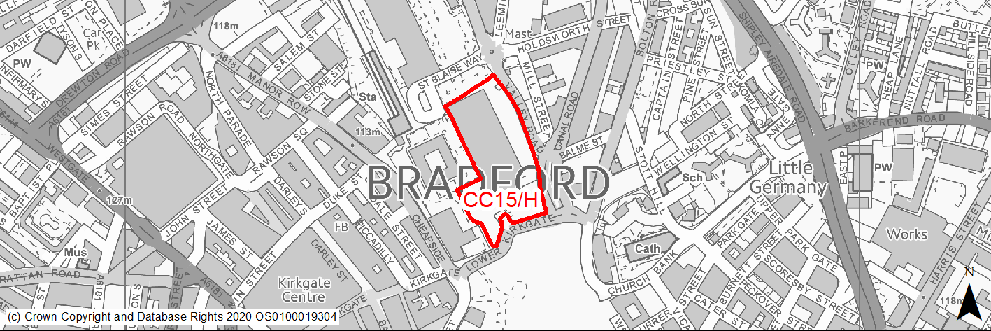
Site location
Regional City of Bradford - City Centre
Ward
City Ward
Site description
Level vacant site of former Royal Mail Sorting Office located between Broadway, Forster Square station and Valley Road.
Proposed Allocation
Mixed Use
SHLAA referencce
CC/044
Indicative no. dwellings
300
Site area (Gross) (ha)
1.73
Ownership
Private
Delivery timescales
Developable (6-11 years)
Type (PDL/Greenfield)
PDL
Green Belt
No
Flood Zone
Flood Zone 1, Flood Zone 2 and Flood Zone 3a.
Potential site access
The site can be accessed from the surrounding road network. The existing site entrances into the car park on Canal Road would need to be closed and St Blaise Way should be considered as a sole access / egress for the development.
Public Transport Accessibility
Site within 400m of a bus stop and 800m of a rail station (Bradford Forster Square).
Sustainability Appraisal
Site has been subject to a recent Sustainability Appraisal (SA) as part of the Area Action Plan process, for additional appraisal commentary please see the site reference within the Sustainability Appraisal accompanying the Local Plan.
Habitats Regulations Assessment
This site is beyond the zones of influence of the South Pennine Moors SPA/SAC and is therefore unlikely to have any significant effects, a HRA is not required.
Green Belt
N/A - Site not within the Green Belt.
Constraints and Opportunities
• The site is currently located with Flood Zone 2 and 3a, with areas of medium/high surface water flood risk within the site.
• The site is located between two Conservation Areas and adjoins the Grade II Listed Midland Hotel.
• New high quality public realm should be delivered through the redevelopment of the site to create a new gateway location for the city linked to the enhancements to Forster Square station.
• Part of this site may contain pockets of important and significant archaeological remains from the post medieval period to the 18th century.
Development considerations
• Any planning application on this site must be supported by a site-specific Flood Risk assessment.
• Development of the Sorting Office site should be considered in conjunction with the adjacent rail station car park and the Westfield site compound at Forster Court.
• As the site is currently in more than one ownership, any individual applications for constituent parts of the site should demonstrate how they contribute to the wider strategic objectives of the site.
• Any scheme should improve north-south pedestrian links between the central shopping area/Broadway and the Forster Square Retail Park and railway station.
• The potential of creating east-west routes between the Cathedral Quarter and station should also be explored.
• New buildings should define the edge of the routes and should respond positively to the corners of Valley Road where it meets Lower Kirkgate and St Blaise Way.
• Active ground floor frontages and improvements to the public realm should be provided on the key routes of St Blaise Way, Valley Road and Lower Kirkgate.
• The scale of new development should respond to the surrounding historic context of the Cathedral Quarter and the Midland Hotel.
• The wall of the former Midland Railway Station should be incorporated / retained as part of any scheme.
• Development will be required to minimise traffic generation and incorporate a travel plan taking into account the adjacent core public transport, cycling and walking networks.
Conclusion/Summary
The site was previously allocated for mixed use in the City Centre AAP (CH1.2). This is a sustainably located brownfield site within the settlement boundary which will deliver approximately 300 residential units.
(3) CC16/H - North Brook Street, Valley Road

Site location
Regional City of Bradford - City Centre
Ward
City Ward
Site description
Level site east of Forster Square Retail Park consisting of a mix of uses including surface car parking, vacant plots, retail, office uses and car repairs.
Proposed Allocation
Housing
SHLAA referencce
CC/045
Indicative no. dwellings
300
Site area (Gross) (ha)
1.67
Ownership
Private
Delivery timescales
Developable 6-15years
Type (PDL/Greenfield)
PDL
Green Belt
No
Flood Zone
Flood Zone 2 and Flood Zone 3a
Potential site access
Primary vehicular access should be from Canal Road and Holdsworth Street Road or Hamme Strasse.
Public Transport Accessibility
Site within 400m of a bus stop and 800m of a rail station (Bradford Forster Square).
Sustainability Appraisal
Site has been subject to a recent Sustainability Appraisal (SA) as part of the Area Action Plan process, for additional appraisal commentary please see the site reference within the Sustainability Appraisal accompanying the Local Plan.
Habitats Regulations Assessment
This site is beyond the zones of influence of the South Pennine Moors SPA/SAC and is therefore unlikely to have any significant effects, a HRA is not required.
Green Belt
N/A - Site not within the Green Belt.
Constraints and Opportunities
• Part of site former landfill.
• The site is currently located in Flood Zone 3a.
• The site has a number of important road frontages - Valley Road, Canal Road, Hamm Strasse and Holdsworth Street. Any new buildings should define and enclose these routes in terms of their scale and building line.
• The site is appropriate for tall buildings of high quality design.
Development considerations
• A Masterplan will be required to establish the design framework and principles for the site which is in a number of different ownerships.
• A new area of public realm should be provided as part of any development and pedestrian permeability should be provided through the site connecting in to the wider network of routes.
• Any planning application on this site must be supported by a site-specific Flood Risk Assessment.
Conclusion/Summary
The site was previously allocated for residential use in the City Centre AAP (CH1.1). It has now been amended to remove parts in current use. This is a sustainably located brownfield site within the settlement boundary and can deliver at least approximately 300 residential units.
(2) CC17/H - High Point
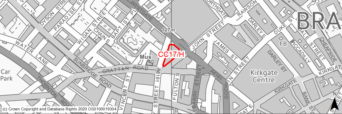
Site location
Regional City of Bradford - City Centre
Ward
City Ward
Site description
The site is currently occupied by the vacant former head quarters of the Yorkshire Building Society.
Proposed Allocation
Housing
SHLAA referencce
CC/047
Indicative no. dwellings
87
Site area (Gross) (ha)
0.12
Ownership
Private
Delivery timescales
Deliverable (0-5 years)
Type (PDL/Greenfield)
PDL
Green Belt
No
Flood Zone
Flood Zone 1
Potential site access
The site can be accessed from the surrounding road network. Some basement or undercroft parking may be acceptable with access off Providence Street. Amendments to TROs around site would also be required.
Public Transport Accessibility
Site within 400m of a bus stop and 800m of a rail station (Bradford Forster Square).
Sustainability Appraisal
Site has been subject to a recent Sustainability Appraisal (SA) as part of the Area Action Plan process, for additional appraisal commentary please see the site reference within the Sustainability Appraisal accompanying the Local Plan.
Habitats Regulations Assessment
This site is beyond the zones of influence of the South Pennine Moors SPA/SAC and is therefore unlikely to have any significant effects, a HRA is not required.
Green Belt
N/A - Site not within the Green Belt.
Constraints and Opportunities
• Air quality issues - site bordered by 3 heavily trafficked roads.
• Existing brutalist building of significant scale on key prominent gateway site into the city centre.
• Current external appearance of existing building is poor quality.
Development considerations
• As part of the refurbishment of the existing building there is an opportunity to improve its external appearance and provide active ground floor uses and surrounding public realm.
Conclusion/Summary
The site was previously allocated for residential use in the City Centre AAP (M1.4). This is a sustainably located site within the settlement boundary with recent prior notification approval which will deliver 87 residential units.
(3) CC18/H - Buildings on Canal Road and Bolton Road
Site location
Regional City of Bradford - City Centre
Ward
City Ward
Site description
The site comprises part vacant 4/5 storey historic mill buildings located between Canal Road and Bolton Road.
Proposed Allocation
Housing
SHLAA referencce
CC/068A, D, E
Indicative no. dwellings
154
Site area (Gross) (ha)
0.22
Ownership
Private
Delivery timescales
Developable (6-11 years)
Type (PDL/Greenfield)
PDL
Green Belt
No
Flood Zone
Flood Zone 1
Potential site access
The site can be accessed from the surrounding road network.
Public Transport Accessibility
Site within 400m of a bus stop and over 800m of a rail station (Bradford Forster Square).
Sustainability Appraisal
See individual Sustainability Appraisal site comment in the accompanying report.
Habitats Regulations Assessment
This site is beyond the zones of influence of the South Pennine Moors SPA/SAC and is therefore unlikely to have any significant effects, a HRA is not required.
Green Belt
N/A - Site not within the Green Belt.
Constraints and Opportunities
• The former warehouse buildings comprise listed and unlisted assets of high architectural/heritage value.
• The site is located within the Cathedral Precinct Conservation Area.
• Air quality issues.
Development considerations
• The existing buildings are of architectural and heritage value and should be retained and converted.
• The conversion should maintain the traditional features and details of this listed buildings, originally warehousing.
• Development proposals should respond sensitively to the surrounding historic context and safeguard the character and setting of the Listed Building and adjacent listed buildings and conservation area.
• Development will be required to minimise traffic generation and incorporate a travel plan taking into account the adjacent core public transport, cycling and walking networks.
Conclusion/Summary
This is a sustainably located brownfield site within the settlement boundary, which will deliver approximately 154 residential units.
(3) CC19/H - 16-18 Mill Street
Site location
Regional City of Bradford - City Centre
Ward
City Ward
Site description
The site comprises part vacant historic Grade II Listed mill building located on Mill Street.
Proposed Allocation
Housing
SHLAA referencce
CC/068G
Indicative no. dwellings
27
Site area (Gross) (ha)
0.06
Ownership
Private
Delivery timescales
Deliverable (0-5 years)
Type (PDL/Greenfield)
PDL
Green Belt
No
Flood Zone
Flood Zone 1, Flood Zone 2 and Flood Zone 3a.
Potential site access
The site can be accessed from the existing access on Mill Street.
Public Transport Accessibility
Site within 400m of a bus stop and over 800m of a rail station (Bradford Forster Square).
Sustainability Appraisal
See individual Sustainability Appraisal site comment in the accompanying report.
Habitats Regulations Assessment
This site is beyond the zones of influence of the South Pennine Moors SPA/SAC and is therefore unlikely to have any significant effects, a HRA is not required.
Green Belt
N/A - Site not within the Green Belt.
Constraints and Opportunities
• The former warehouse building is grade II listed.
• The site is located within the Cathedral Precinct Conservation Area.
• Flood Risk - located within Flood Zone 2 and 3a,with also areas of medium/high surface water flood risk.
Development considerations
• Development proposals should respond sensitively to the surrounding historic context, and safeguard the character and setting of the Listed Building and adjacent listed buildings and conservation area.
Conclusion/Summary
This is a sustainably located brownfield site within the settlement boundary, which will deliver approximately 27 units.
(2) CC20/H - Thornton Road North
Site location
Regional City of Bradford - City Centre
Ward
City Ward
Site description
The site comprises land and buildings which are part vacant and part currently occupied, uses on the site include car repairs and door and gate sales, with unused upper floors.
Proposed Allocation
Housing
SHLAA referencce
CC/073
Indicative no. dwellings
80
Site area (Gross) (ha)
0.35
Ownership
Private
Delivery timescales
Developable (6-11 years)
Type (PDL/Greenfield)
PDL
Green Belt
No
Flood Zone
Flood Zone 1 and 2
Potential site access
The site would be suitable for car free development given its accessible city centre location and closeness to a major signal junction.
Public Transport Accessibility
Site within 400m of a bus stop and 800m of a rail station (Bradford Interchange/Forster Square).
Sustainability Appraisal
Site has been subject to a recent Sustainability Appraisal (SA) as part of the Area Action Plan process, for additional appraisal commentary please see the site reference within the Sustainability Appraisal accompanying the Local Plan.
Habitats Regulations Assessment
This site is beyond the zones of influence of the South Pennine Moors SPA/SAC and is therefore unlikely to have any significant effects, a HRA is not required.
Green Belt
N/A - Site not within the Green Belt.
Constraints and Opportunities
• The site is currently located with Flood Zone 2.
• The site lies within the Goitside Conservation Area and the design of new development should respond sensitively to the surrounding historic context.
• The site would be suitable for car free development given its accessible city centre location and closeness to a major signal junction.
Development considerations
• The scale and building line of new development should help to repair the urban fabric of the area along Thornton Road.
• New buildings should respond positively to the valley which runs through the site above the watercourse of the Goit. This route should be enhanced with new surfacing and courtyard spaces.
• Any development should include new street trees to improve the pedestrian environment on Thornton Road.
• TROs may be required to control on-street parking around the site.
Conclusion/Summary
The site was previously allocated for residential use in the City Centre AAP (V/1.5). This is a sustainably located brownfield site/buildings within the settlement boundary which will deliver approximately 80 residential units.
(3) CC21/H - Burnett Street Car Park
Site location
Regional City of Bradford - City Centre
Ward
City Ward
Site description
The site currently operates as a pay and display surface car park.
Proposed Allocation
Housing
SHLAA referencce
CC/076
Indicative no. dwellings
60
Site area (Gross) (ha)
0.31
Ownership
Council
Delivery timescales
Developable (6-11 years)
Type (PDL/Greenfield)
PDL
Green Belt
No
Flood Zone
Flood Zone 1
Potential site access
The site has existing vehicular access from Burnett Street.
Public Transport Accessibility
Site within 400m of a bus stop and 800m of a rail station (Bradford Forster Square).
Sustainability Appraisal
Site has been subject to a recent Sustainability Appraisal (SA) as part of the Area Action Plan process, for additional appraisal commentary please see the site reference within the Sustainability Appraisal accompanying the Local Plan.
Habitats Regulations Assessment
This site is beyond the zones of influence of the South Pennine Moors SPA/SAC and is therefore unlikely to have any significant effects, a HRA is not required.
Green Belt
N/A - Site not within the Green Belt.
Constraints and Opportunities
• Air quality and noise issues connected with adjoining Shipley/Airedale Road.
• The site lies within the Little Germany Conservation Area and there are a number of Listed Buildings in its vicinity.
• Potential land stability issues - unrecorded shallow coal workings.
• The layout and scale of the buildings should respond to the sloping nature of the site.
Development considerations
• New development should respond positively to the corners of the site, particularly at the junction of Barkerend Road/Shipley Airedale Road which should be a gateway feature.
• The scale and design of new development should respond sensitively to the surrounding historic context, and safeguard the character and setting of the nearby listed buildings.
• Strong landscaping will mitigate against the impact of the road junction.
Conclusion/Summary
The site was previously allocated for residential use in the City Centre AAP (CH1.5). This is a sustainably located brownfield site within the settlement boundary which will deliver approximately 60 residential units.
(2) CC22/H - East Parade Car Park
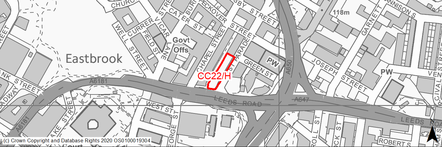
Site location
Regional City of Bradford - City Centre
Ward
City Ward
Site description
The site currently operates as a pay and display surface car park.
Proposed Allocation
Housing
SHLAA referencce
CC/078
Indicative no. dwellings
50
Site area (Gross) (ha)
0.14
Ownership
Private
Delivery timescales
Developable (6-11 years)
Type (PDL/Greenfield)
PDL
Green Belt
No
Flood Zone
Flood Zone 1
Potential site access
Some undercroft parking may be acceptable with access from East Parade.
Public Transport Accessibility
Site within 400m of a bus stop and 800m of a rail station (Bradford Forster Square/Interchange).
Sustainability Appraisal
Site has been subject to a recent Sustainability Appraisal (SA) as part of the Area Action Plan process, for additional appraisal commentary please see the site reference within the Sustainability Appraisal accompanying the Local Plan.
Habitats Regulations Assessment
This site is beyond the zones of influence of the South Pennine Moors SPA/SAC and is therefore unlikely to have any significant effects, a HRA is not required.
Green Belt
N/A - Site not within the Green Belt.
Constraints and Opportunities
• Air quality issues.
• The site lies within the Little Germany Conservation Area and there is a group of Grade II Listed Buildings to the north-west.
• The site may be suitable for car free development given its sustainable location.
Development considerations
• The scale and design of new development should respond sensitively to the surrounding historic context, and safeguard the character and setting of the nearby listed buildings.
Conclusion/Summary
The site was previously allocated for residential use in the City Centre AAP (CH1.7). This is a sustainably located brownfield site within the settlement boundary which will deliver approximately 50 residential units.
(3) CC23/H - Land West of Wharf Street
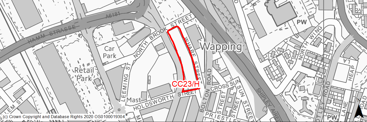
Site location
Regional City of Bradford - City Centre
Ward
City Ward
Site description
The site is currently a vacant plot of land following the demolition of the industrial building (saw mill) a number of years ago. Part of the site currently operates as a rough-surfaced car park.
Proposed Allocation
Housing
SHLAA referencce
CC/095
Indicative no. dwellings
100
Site area (Gross) (ha)
0.49
Ownership
Private
Delivery timescales
Developable (6-11 years)
Type (PDL/Greenfield)
PDL
Green Belt
No
Flood Zone
Flood Zone 1
Potential site access
Primary vehicular access from Wharf Street would be desirable but an access off Canal Road at the western end of the site may be acceptable to serve a small car parking area.
Public Transport Accessibility
Site within 400m of a bus stop and 800m of a rail station (Bradford Forster Square).
Sustainability Appraisal
Site has been subject to a recent Sustainability Appraisal (SA) as part of the Area Action Plan process, for additional appraisal commentary please see the site reference within the Sustainability Appraisal accompanying the Local Plan.
Habitats Regulations Assessment
This site is beyond the zones of influence of the South Pennine Moors SPA/SAC and is therefore unlikely to have any significant effects, a HRA is not required.
Green Belt
N/A - Site not within the Green Belt.
Constraints and Opportunities
• The site lines Canal Road, one of the main routes into the city centre.
• The site is suitable for new tall buildings in accordance with the principles set out in the Bradford City Centre Design Guide SPD.
• The scale and design of new development should respond sensitively to the character of the adjacent Cathedral Precinct Conservation Area.
Development considerations
• New development should positively address this street in terms of scale, building line, and animating the street at ground floor level.
• The site should contribute towards improving the pedestrian environment and footway on Canal Road, including new tree planting.
Conclusion/Summary
The site was previously allocated for residential use in the City Centre AAP (CH1.8). This is a sustainably located brownfield site within the settlement boundary which will deliver approximately 100 residential units.
(2) CC24/H - Cathedral Quarter A
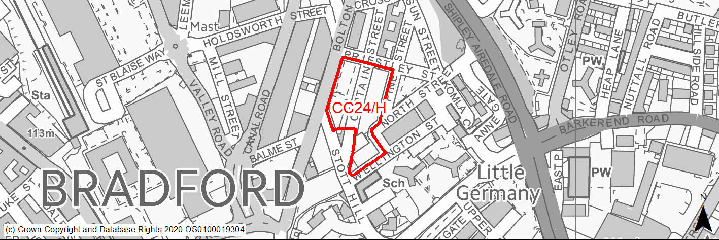
Site location
Regional City of Bradford - City Centre
Ward
City Ward
Site description
The site consists of a number of surface car parks either side of Captain Street.
Proposed Allocation
Housing
SHLAA referencce
CC/096
Indicative no. dwellings
90
Site area (Gross) (ha)
0.7
Ownership
Private
Delivery timescales
Developable (6-11 years)
Type (PDL/Greenfield)
PDL
Green Belt
No
Flood Zone
Flood Zone 1
Potential site access
Primary vehicular access should be from Captain Street and/or Priestley Street. There should be no direct vehicular access to Bolton Road or Stott Hill.
Public Transport Accessibility
Site within 400m of a bus stop and 800m of a rail station.
Sustainability Appraisal
Site has been subject to a recent Sustainability Appraisal (SA) as part of the Area Action Plan process, for additional appraisal commentary please see the site reference within the Sustainability Appraisal accompanying the Local Plan.
Habitats Regulations Assessment
This site is beyond the zones of influence of the South Pennine Moors SPA/SAC and is therefore unlikely to have any significant effects, a HRA is not required.
Green Belt
N/A - Site not within the Green Belt.
Constraints and Opportunities
• Bolton Road is a key route into the city centre and new development should define the edge of the street, be of an appropriate scale and provide active frontages at ground floor level.
• The layout and scale of the buildings should respond to the sloping nature of the site and positive patterns of development in the area.
• Any new development should relate well to and improve the quality of the existing footpaths between Bolton Road and Stott Hill.
• The stone setted route of Captain Street should be retained and exploited as a focus of the development.
• The corner of Captain Street and Stott Hill could offer the opportunity for a new area of public realm.
• The site is adjacent the Cathedral Precinct Conservation Area and within 50m buffer of two listed buildings.
Development considerations
• The scale and design of new development should respond sensitively to the surrounding historic context, and safeguard the character and setting of the two Listed Buildings.
• Road gradients should be a maximum 1 in 15, though 1 in 20 is desirable.
• The site is located in the city centre and therefore the development would be required to minimise traffic generation and incorporate a travel plan taking into account the adjacent core public transport, cycling and walking networks.
Conclusion/Summary
The site was previously allocated for residential use in the City Centre AAP (CH1.3). This is a sustainably located brownfield site within the settlement boundary, with outline planning approval which would deliver an estimated 90 dwellings on part of the site.
(3) CC25/H - Land to the rear of Cathedral House
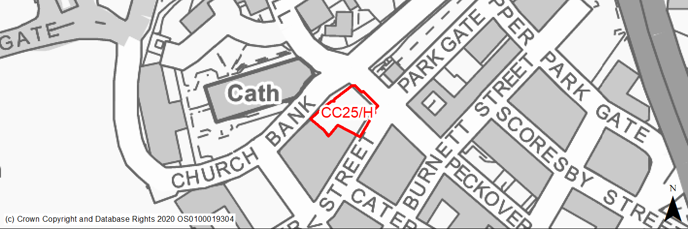
Site location
Regional City of Bradford - City Centre
Ward
City Ward
Site description
The site was formerly warehousing, before being demolished and cleared, and is currently operating as a surface car park.
Proposed Allocation
Housing
SHLAA referencce
CC/097
Indicative no. dwellings
20
Site area (Gross) (ha)
0.08
Ownership
Council
Delivery timescales
Developable (6-11 years)
Type (PDL/Greenfield)
PDL
Green Belt
No
Flood Zone
Flood Zone 1
Potential site access
Some undercroft parking may be acceptable with access from Currer Street.
Public Transport Accessibility
Site within 400m of a bus stop and 800m of a rail station (Bradford Forster Square).
Sustainability Appraisal
Site has been subject to a recent Sustainability Appraisal (SA) as part of the Area Action Plan process, for additional appraisal commentary please see the site reference within the Sustainability Appraisal accompanying the Local Plan.
Habitats Regulations Assessment
This site is beyond the zones of influence of the South Pennine Moors SPA/SAC and is therefore unlikely to have any significant effects, a HRA is not required.
Green Belt
N/A - Site not within the Green Belt.
Constraints and Opportunities
• This site lies within the Little Germany Conservation Area and adjacent to the boundary of the Cathedral Quarter Conservation Area. It has Grade II listed buildings to its south-west and north-east and lies opposite the Grade I Listed Cathedral Church of St Peter.
• The site may contain pockets of important archaeological remains from the medieval period to the 18th century.
• The site may be suitable for car free development given its sustainable location.
Development considerations
• Any development on the site should respond to the building line, scale and design quality of existing buildings in the locality.
• The scale and design of new development should respond sensitively to the surrounding historic context, and safeguard the character and setting of the Conservation Areas at Little Germany and the Cathedral Quarter and of the surrounding listed buildings (including St Peter’s Cathedral).
Conclusion/Summary
The site was previously allocated for residential use in the City Centre AAP (CH1.10). This is a sustainably located brownfield site within the settlement boundary which will deliver approximately 20 residential units.
(2) CC26/H - Gate Haus 2
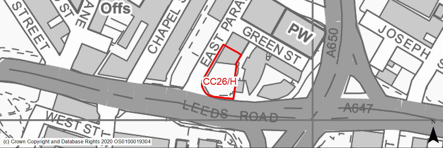
Site location
Regional City of Bradford - City Centre
Ward
City Ward
Site description
The site was formerly warehousing and garages, before being demolished and cleared, and is currently operating as a surface car park.
Proposed Allocation
Housing
SHLAA referencce
CC/099
Indicative no. dwellings
20
Site area (Gross) (ha)
0.14
Ownership
Private
Delivery timescales
Developable (6-11 years)
Type (PDL/Greenfield)
PDL
Green Belt
No
Flood Zone
Flood Zone 1
Potential site access
Some undercroft parking may be acceptable with access from East Parade.
Public Transport Accessibility
Site within 400m of a bus stop and 800m of a rail station (Bradford Interchange).
Sustainability Appraisal
Site has been subject to a recent Sustainability Appraisal (SA) as part of the Area Action Plan process, for additional appraisal commentary please see the site reference within the Sustainability Appraisal accompanying the Local Plan.
Habitats Regulations Assessment
This site is beyond the zones of influence of the South Pennine Moors SPA/SAC and is therefore unlikely to have any significant effects, a HRA is not required.
Green Belt
N/A - Site not within the Green Belt.
Constraints and Opportunities
• The site lies adjacent the Little Germany Conservation Area and there are a number of Listed Buildings located close by.
• Air quality issues.
Development considerations
• Any development should create positive frontages to Leeds Road and East Parade and should animate the street at ground floor level.
• New development should respond to the existing positive character in Little Germany in terms of scale, building line and design quality, as well as contributing towards improving the pedestrian environment and footway on Leeds Road.
Conclusion/Summary
The site was previously allocated for residential use in the City Centre AAP (M1.3). This is a sustainably located brownfield site within the settlement boundary which will deliver approximately 20 residential units.
(2) CC27/H - Stone Street
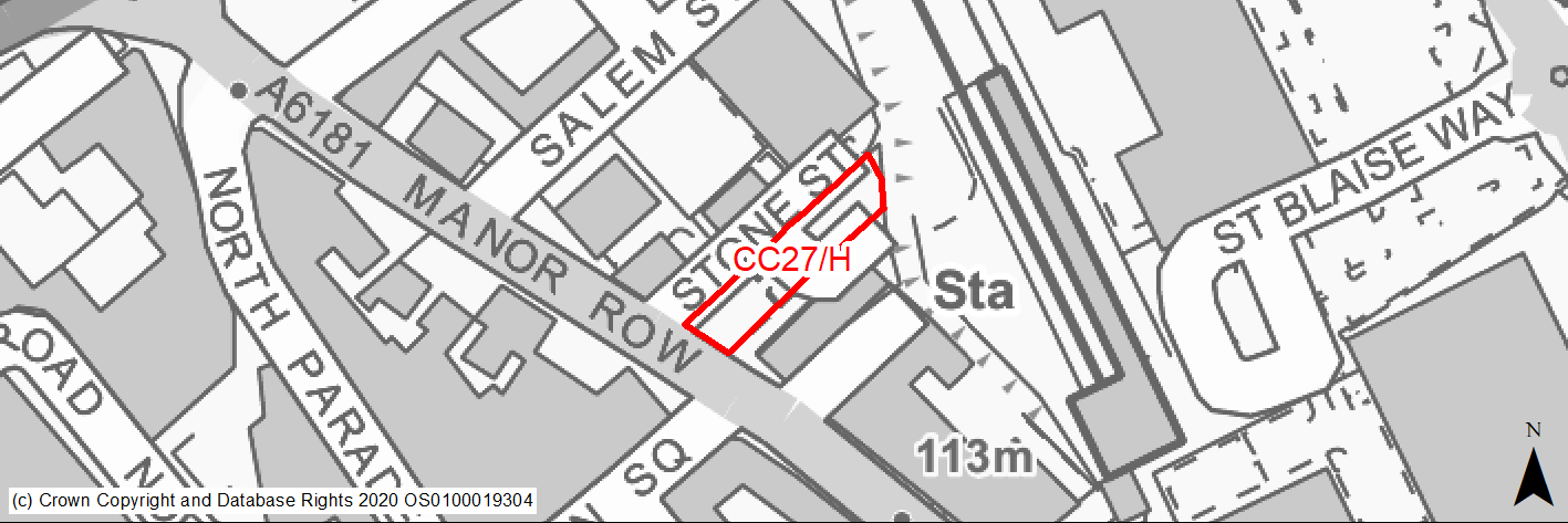
Site location
Regional City of Bradford - City Centre
Ward
City Ward
Site description
The site currently operates as a surface car park for the surrounding businesses.
Proposed Allocation
Housing
SHLAA referencce
CC/100
Indicative no. dwellings
20
Site area (Gross) (ha)
0.16
Ownership
Private
Delivery timescales
Developable (6-11 years)
Type (PDL/Greenfield)
PDL
Green Belt
No
Flood Zone
Flood Zone 1
Potential site access
The site can be accessed from the surrounding road network.
Public Transport Accessibility
Site within 400m of a bus stop and 800m of a rail station (Bradford Forster Square).
Sustainability Appraisal
Site has been subject to a recent Sustainability Appraisal (SA) as part of the Area Action Plan process, for additional appraisal commentary please see the site reference within the Sustainability Appraisal accompanying the Local Plan.
Habitats Regulations Assessment
This site is beyond the zones of influence of the South Pennine Moors SPA/SAC and is therefore unlikely to have any significant effects, a HRA is not required.
Green Belt
N/A - Site not within the Green Belt.
Constraints and Opportunities
• The site is within the top of town City Village Masterplan area.
• The site lies within the city Centre Conservation Area and directly adjacent a Grade II listed building (Registry Office) to the south.
• Existing trees to rear of the site.
• The site lends itself to a linear form of development which defines the edge of Stone Street.
• The site would be suitable for car free development given its highly accessible city centre location.
Development considerations
• Any development will need to face onto Stone Street and Manor Row.
• The scale of new buildings should respond to those adjacent on Stone Street and Manor Row.
• The scale and design of new development should respond sensitively to the surrounding historic context and safeguard the character and setting of the adjacent listed buildings.
Conclusion/Summary
The site was previously allocated for residential use in the City Centre AAP (M1.3). This is a sustainably located brownfield site within the settlement boundary which will deliver approximately 20 residential units.
(3) CC28/H - Land and buildings east of Grattan Road
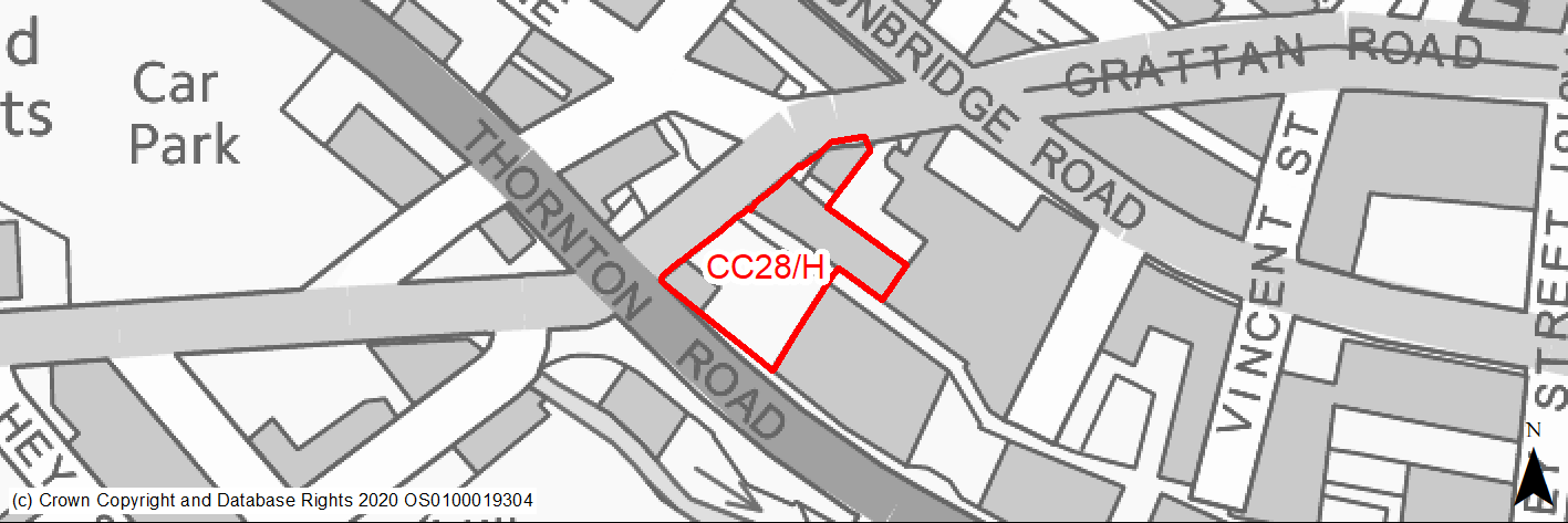
Site location
Regional City of Bradford - City Centre
Ward
City Ward
Site description
The site is currently part occupied and consists of large mill building and warehouse (Holdings Mill) with the southern part operating as a stone salvage and reclamation.
Proposed Allocation
Housing
SHLAA referencce
CC/113
Indicative no. dwellings
80
Site area (Gross) (ha)
0.2
Ownership
Private
Delivery timescales
Developable (6-11 years)
Type (PDL/Greenfield)
PDL
Green Belt
No
Flood Zone
Flood Zone 1
Potential site access
Site access is available from Lower Grattan Road. Direct access onto Thornton Road from existing access is unlikely to be acceptable.
Public Transport Accessibility
Site within 400m of a bus stop and 800m of a rail station (Bradford Interchange/Forster Square).
Sustainability Appraisal
Site has been subject to a recent Sustainability Appraisal (SA) as part of the Area Action Plan process, for additional appraisal commentary please see the site reference within the Sustainability Appraisal accompanying the Local Plan.
Habitats Regulations Assessment
This site is beyond the zones of influence of the South Pennine Moors SPA/SAC and is therefore unlikely to have any significant effects, a HRA is not required.
Green Belt
N/A - Site not within the Green Belt.
Constraints and Opportunities
• The site is located within the Goitside Conservation Area.
• Hollins Mill is a key unlisted heritage building.
• Air quality issues.
• Thornton Road is very busy.
• The site provides a negative contribution to character of the conservation area. Development would help to provide a more positive contribution and bring back into use a part vacant key unlisted building.
Development considerations
• Hollins Mill is a key unlisted building of high architectural/heritage value and should be retained and existing building converted.
• Development proposals should maintain the traditional features and details of this key unlisted building which was originally a textile mill. Development proposals should respond sensitively to the surrounding historic context, and safeguard the character and setting of adjacent listed buildings and conservation area.
• Development will be required to minimise traffic generation and incorporate a travel plan taking into account the adjacent core public transport, cycling and walking networks.
Conclusion/Summary
This is a sustainably located brownfield site within the settlement boundary which will deliver approximately 80 residential units.
(3) CC29/H - Former college Old Building, Great Horton Road
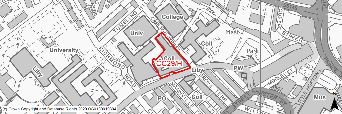
Site location
Regional City of Bradford - City Centre
Ward
City Ward
Site description
The site comprises the former Bradford College Old Building.
Proposed Allocation
Housing
SHLAA referencce
CC/114
Indicative no. dwellings
190
Site area (Gross) (ha)
0.58
Ownership
Private
Delivery timescales
Deliverable (0-5 years)
Type (PDL/Greenfield)
PDL
Green Belt
No
Flood Zone
Flood Zone 1
Potential site access
The site has existing restricted vehicular access from Carton Street.
Public Transport Accessibility
Site within 400m of a bus stop and 800m of a rail station (Bradford Interchange).
Sustainability Appraisal
See individual Sustainability Appraisal site comment in the accompanying report.
Habitats Regulations Assessment
This site is beyond the zones of influence of the South Pennine Moors SPA/SAC and is therefore unlikely to have any significant effects, a HRA is not required.
Green Belt
N/A - Site not within the Green Belt.
Constraints and Opportunities
• The building is a Grade II listed, considered to be one of the most historic and iconic buildings in Bradford city centre.
• Air quality issues with on street parking adjacent on adjacent highways and footways, the change to residential may exacerbate this.
Development considerations
• Any development should involve the retention and conversion of the existing listed buildings.
• Development should respond sensitively to the surrounding historic context, and safeguard the character and setting of the Listed Building and adjacent listed buildings.
• Proposals should minimise any alterations that maybe harmful to the listed building.
Conclusion/Summary
This is a sustainably located brownfield site within the settlement boundary, which will deliver approximately 190 residential units.
(1) CC30/H - 496 Leeds Road
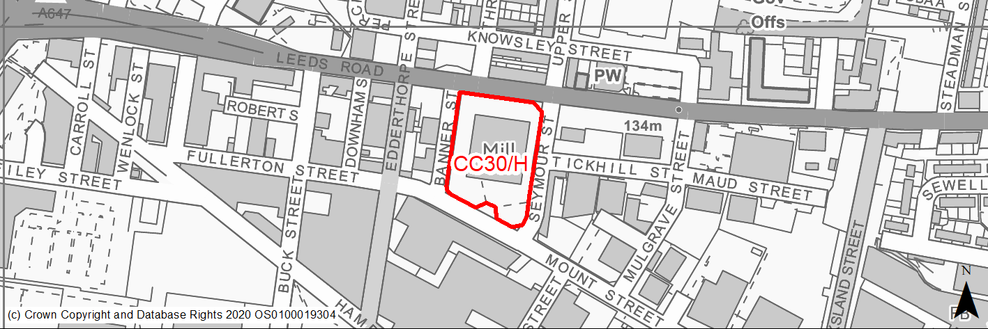
Site location
Regional City of Bradford - City Centre
Ward
Bowling and Barkerend Ward
Site description
The site is level and comprises vacant building and land opposite shops and residential use in a mixed area.
Proposed Allocation
Housing
SHLAA referencce
CC/116 (SE/042)
Indicative no. dwellings
70
Site area (Gross) (ha)
0.78
Ownership
Private
Delivery timescales
Developable (6-11 years)
Type (PDL/Greenfield)
PDL
Green Belt
No
Flood Zone
Flood Zone 2
Potential site access
Site access is available from Lower Mount Street from existing access. Direct access onto Leeds Road is unlikely to be acceptable.
Public Transport Accessibility
Site within 400m of a bus stop and over 800m of a rail station (Bradford Interchange).
Sustainability Appraisal
The site could deliver major positive effects for residents on the health and education SA Objectives as a result of being within the target distances for all necessary health facilities and centres for primary and secondary education.
A significant adverse effect has been predicted for the air quality SA Objective as a result of the site being entirely within the CAZ. Development here could potentially make achieving air quality improvement targets within the CAZ more difficult.
Minor positive effects were predicted for nearly all other socio-economic themed SA Objectives due to the benefits of new residential development for the local economy as well as the location of the site in relation to transport links, local services and amenities, and employment areas.
As a PDL site containing a large building, there are opportunities here for achieving biodiversity net gains and enhancing the local townscape character, depending on the design and implementation of the development.
The only other adverse effect predicted for the site is minor, and related to an increase in water consumption, which has been predicted at nearly all sites.
Habitats Regulations Assessment
This site is beyond the zones of influence of the South Pennine Moors SPA/SAC and is therefore unlikely to have any significant effects, a HRA is not required.
Green Belt
N/A - Site not within the Green Belt.
Constraints and Opportunities
• Air quality issues.
• The site presents an opportunity to regenerate a vacant site and replace an unattractive building on a key Gateway corridor into the city centre.
Development considerations
• Site is suitable for higher density development.
Conclusion/Summary
This is a sustainably located brownfield site within the settlement boundary, which will deliver approximately 70 residential units.