
Draft Bradford District Local Plan - Preferred Options (Regulation 18) February 2021
Silsden
Introduction
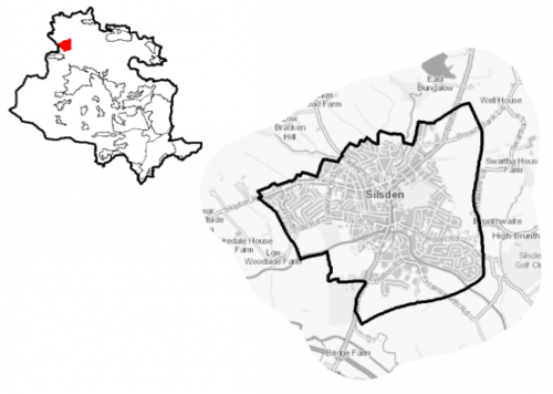
5.13.1 Silsden is situated in the north west of Bradford district, immediately adjacent to the local authority boundary with North Yorkshire (Craven District) on the northern edge of the valley of the River Aire, which flows through the valley bottom around 1km to the south of the town. It is around 7km to the north west of Keighley and 11 km south of Skipton. The River Aire creates a natural division between Silsden and Steeton, approximately 3km to the north. The Leeds and Liverpool Canal, passes through the southern edge of the town. It falls within the Craven Ward together with the settlements of Addingham and Steeton-with-Eastburn and is part of the Keighley Parliamentary Constituency. Silsden Town Council acts as the administrative body for the town.
Figure 1: Location
5.13.2 Silsden is primarily a residential settlement with a local employment base and good connections to nearby towns and cities including Keighley, Leeds, Bradford and Skipton. There are a range of local services and facilities to meet the needs of the local population.
5.13.3 The settlement has a resident population of 7,678. It has a higher percentage of residents (25.7%) who are aged 65 and over, compared to the West Yorkshire average (16.7%), whilst it has a below average population of those under 15 (16.9% compared to sub-regional average of 20%). The largest majority (around 95.8%) of the population identify as being of White British ethnicity which is higher than the West Yorkshire average (78.4%). Household composition data indicates a slightly higher percentage of pensioner households and married households than West Yorkshire averages and a lower percentage of one person households (under 65) and lone parent families with dependent children.
5.13.4 The Town Council is working with the neighbouring Steeton with Eastburn Parish Council to prepare of a Neighbourhood Plan that will help to shape how their communities will grow and develop in the coming years (up to 2030). It sets outs local priorities and policies that will be used, once adopted, as part of the statutory development plan to make decisions on planning applications in the town. The Neighbourhood Plan has recently been subject to an independent examination.
Planning for Prosperity
5.13.5 The Local Plan settlement hierarchy identifies Silsden as a Local Growth Centre. It is considered to be one of the most sustainable locations and is accessible to higher order settlements. As such, it will help make a significant contribution of the meeting the District's housing needs, providing employment and supporting community facilities.
5.13.6 The Craven Ward, which includes Silsden, is positively ranked as 28th of 30 wards in the District against the Index of Multiple Deprivation[1] overall. It is in 28th place for income and employment deprivation and 27th place for education, skills and training deprivation. The economic activity rates similarly indicate a positive position for Silsden with 72.9% of working age residents classified as being economically active compared to the West Yorkshire average of 68.5% with higher percentages of full and part time employees and self-employed people compared to the sub-regional comparisons.
Economy and Employment
5.13.7 Average household income at £40,700 is above the West Yorkshire average of £38,499. In relation to occupations, Silsden has a similar proportion working in managerial and professional occupations as the sub-regional level, whilst those working in administrative occupations and those in skilled trades is also higher – 15% compared to 11.4%.
5.13.8 While Silsden has strong commuting links to nearby larger towns and cities due to its transport links, the settlement has retained a local employment and business base with some notable trading names. Many of these businesses are located mainly in former mill buildings such as Waterloo Mills and Canal Works, the town centre and the Silsden Rural Business Park. Waterloo Mills is home to Snugpak, a sleeping bag and insulated clothing manufacturer, whilst Canal Works has been divided into a number of small business units. Silsden Rural Business Park is located to the south of the town with good access to main road network, and has been very successful in attracting businesses. Other larger businesses include Badgequo, a cosmetics company and the headquarters of the Ecology Building Society is based on Belton Road. Figure 2 shows the main employment area in Silsden. Employment site options have been evaluated in Silsden but it is not proposed to allocate any additional employment land in the settlement.
5.13.9 Business Register and Employment Survey (BRES) data indicates that the three largest industry by workforce jobs (all people in employment) are health (15.5%), wholesale (11.8%) and construction (10.7%). Private sector employment accounts of 85.9% of jobs, with public sector at 5.8%.
Figure 2: Silsden Employment Area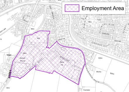
Retail
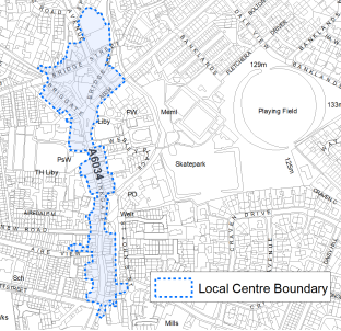
5.13.10 Silsden is designated in the retail hierarchy (Policy EC4) as a Local Centre. The centre is linear in character reflecting the pattern of development along the A6034. It is focussed along Kirkgate, Bolton Road, Briggate and Bridge Street. The centre boundary is shown on the Policies Map and in figure 3 below. The Retail and Leisure Study 2019 considered it to be a viable and healthy centre with low vacancy rates, a good overall environmental quality and accessibility. The centre's convenience offer is above the national average and is underpinned by a Co-op food as well as a further convenience store, two bakeries, newsagent, shoe repair store and a butcher. However, its comparison offer is below the national average. Retail and leisure services are above the national average. The Aldi store provides additional convenience retail choice but lies outside the centre.
Figure 3: Silsden Local Centre
Transport and Accessibility
5.13.11 Silsden is located within the key transport corridor running through the Aire Valley, providing good road and rail connections to nearby major towns and cities. It lies to the north of the A629, the main route through the Aire Valley between Bradford, North Yorkshire and East Lancashire. This gives access to other towns within Airedale including Keighley as well as to Bradford and Skipton. It is connected to it by the A6034 that runs through the centre of the town. The road also links Silsden to the A65 at Addingham in the Wharfedale area, providing a link to Ilkley and an alternative route to North Yorkshire.
5.13.12 The A6034 through the centre of the town has a number of narrow sections or pinchpoints which, together with the historic layout and features of the town, can cause traffic congestion at peak times. It is proposed to undertake a transport study to better understand the key issues within the town as part of wider work on the emerging Transport Strategy and future infrastructure planning.
5.13.14 Public transport links to and from Silsden are considered to be adequate. Steeton and Silsden railway station is located 1.6km to the south of the town on the northern edge of neighbouring Steeton. This provides frequent links to Keighley, Bingley, Shipley, Bradford, Skipton and Leeds. The route to the station involves having to cross the main A629. This acts as a barrier to walking and cycling. Options for addressing this barrier are being explored. The town is also on a high frequency bus route, providing connections to Addingham, Ilkley, Keighley and Steeton (including the railway station). One service per hour extends beyond Ilkley to Burley in Wharfedale, Menston, Otley and Leeds Bradford Airport. National Cycle Network Route 69 runs from Silsden via Hainsworth Road and the towpath of the Leeds and Liverpool Canal towards Keighley (Riddlesden). It then, continues along the towpath (as NCN Route 696) towards Bingley, Saltaire, and Shipley as well as Bradford and Leeds.
5.13.15 Census data indicates that over 83% of the population have access to at least one car or van, which is significantly higher than the sub-regional level. Silsden is not covered by an Air Quality Management Area (AQMA) and lies outside the proposed Clean Air Zone (CAZ).
5.13.16 In relation to digital connectivity, average broadband download speeds in Silsden are around 43 megabytes per second – below the West Yorkshire average, whilst there are 9 premises (0.3%) where speeds are below the Universal Service Obligation (USO)[2], compare to a sub-regional average of 1.1%.
5.13.17 Strategic transport infrastructure projects to be delivered within the plan period and protected routes are set out on the Policies Map with the local plan. Key initiatives within Silsden are detailed in Table 1 below.
Table 1: Silsden Transport Projects
|
Policies Map Ref. |
Project Name |
|
TR1.A.5 |
Airedale Greenway (Leeds Liverpool Canal Towpath Ongoing) |
|
TR1.B.2 |
Steeton and Silsden Railway station improvements and Parking Extension |
Planning for Homes
5.13.18 Silsden has 3,544 dwellings, the largest proportion of which (39.1%) are terraced properties, above the West Yorkshire average. Semi-detached dwellings form the second largest proportion of dwellings (28.7%); however, this is below the West Yorkshire average. The percentage detached dwellings (21.7%) is above average. Figure 4 below provides further analysis of local house types.
Figure 4: Silsden – Housing Types
|
Detached |
Semi-detached |
Terraced |
Purpose built flat |
|||
|
768 |
1,015 |
1,383 |
259 |
|||
|
21.7% (West Yorkshire average = 16.4%) |
28.7% (West Yorkshire average = 36.0%) |
39.1% (West Yorkshire average = 30.7%) |
7.3% (West Yorkshire average = 13.7%) |
|||
|
Flat (in converted house) |
Flat (in commercial property) |
Caravan or other temporary dwelling |
Second homes (2001) |
|||
|
74 |
35 |
04 |
06 |
|||
|
2.1% (West Yorkshire average = 2.2%) |
1.0% (West Yorkshire average = 0.8%) |
0.1% (West Yorkshire average = 0.2%) |
0.2% (West Yorkshire average = 0.2%) |
|||
|
Source: Census 2011 |
||||||
5.13.19 The majority (78%) of dwellings are owner occupied, which is above the average for West Yorkshire. Levels of renting is below the West Yorkshire and national averages (22% compared with 36.5% and 35.9% respectively), with private and other forms of renting being largest proportion (see Figure 5):
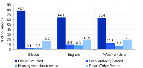
Figure 5: Silsden Housing Tenure
5.13.20 The average house price (across all dwelling types) for Silsden is £189,162 compared with a West Yorkshire average of £183,194. Average property prices per dwelling type, with the exception of flats, are higher than the West Yorkshire average. The total affordability ratio between house prices and annual earnings which is usually used as a proxy for number of years' worth of earnings required for a house deposit, is 3.88 compared to a West Yorkshire average of 2.96.
5.13.21 Delivering new housing is a key part of the overall development strategy for Silsden. It will ensure that the housing needs and aspirations of local people can be met, together with those of future residents, including the provision market and affordable housing. In addition, it will support the economy and reflect its role as a Local Growth Centre.
5.13.22 Policy SP8 sets out a requirement of 700 dwellings that will be delivered in Silsden during the plan period. These will be delivered through a mix of committed sites and new site allocations. Table 2 below sets out the housing position for Silsden which also include application of non-implementation of non-implementation or discount rates for planning permissions and allocations.
5.13.23 Development of site allocations should be in accordance with specified development guidelines and approximate site provision figures and all other relevant policies of this Local Plan.
Table 2: Silsden – Summary of Housing Requirement and Supply
|
Housing Target |
700 |
|
Carried Forward Commitments |
224 |
|
Commitments Discounted by 10% |
202 |
|
Remaining Allocation Requirement |
498 |
|
Identified Allocations |
580 |
|
Allocations Discounted by 10% |
522 |
|
Total Supply Contribution from Allocations |
522 |
5.13.24 Once the commitments are discounted and removed from the supply this leaves a residual allocation requirement of 498 units. The evaluated total site supply of housing units from preferred allocation sites equates to 580 units which is in turn discounted by 10% for non-implementation leaving a final allocation contribution of 522 units across all sites, which is above the allocation requirement but is reflective of site yield and the practicalities of redefining strong settlement boundaries. The Council will be supportive of additional proposals for new homes on additional small sites, particularly those that provide a redevelopment opportunity to bring forward land which has been previously used. Support will also be provided to developers who wish to redevelop larger sites and/or buildings for new homes not currently identified, subject to all relevant policies in the Local Plan
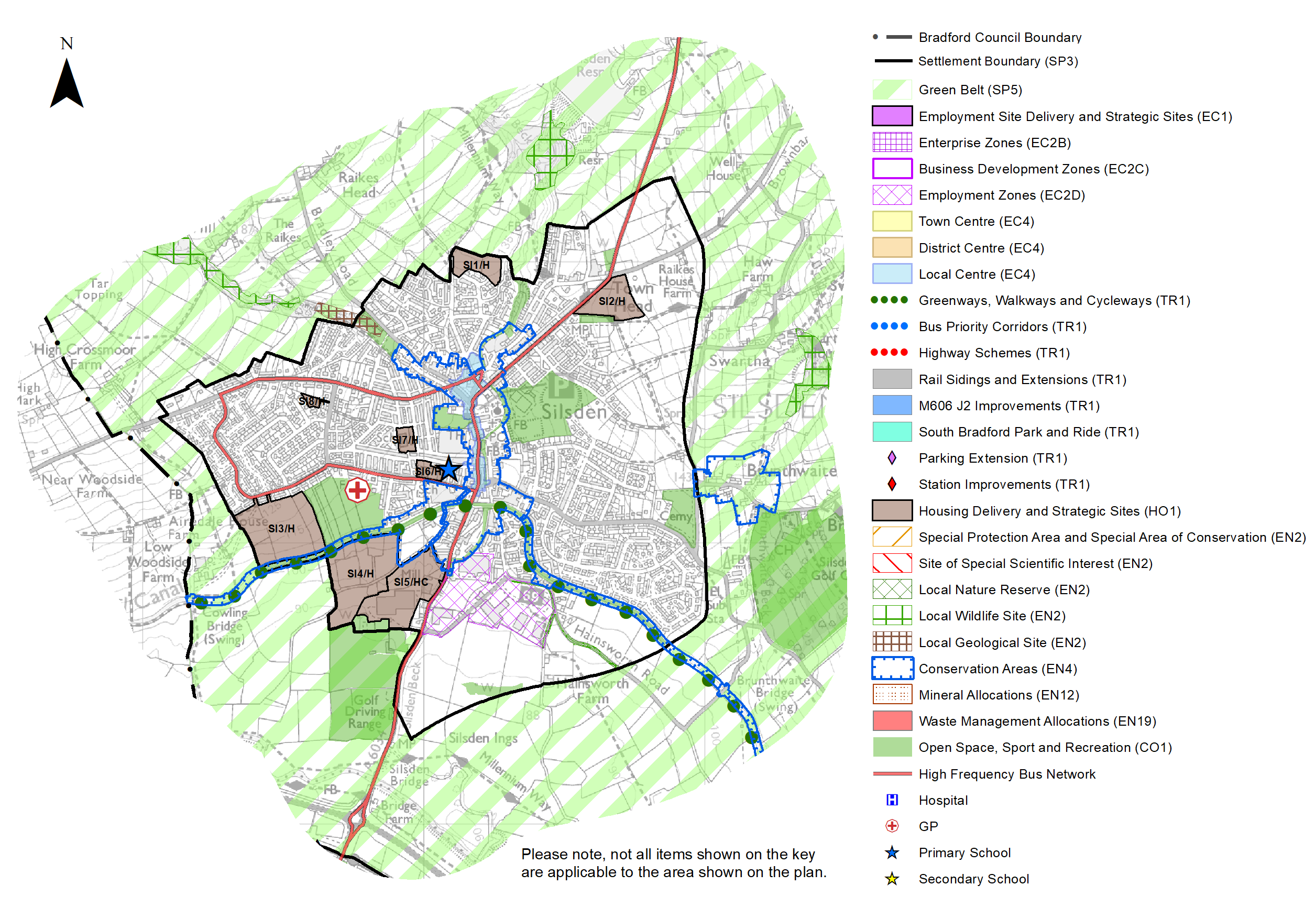
5.13.25 Silsden is not constrained for allocations and sites lie within the established settlement boundary. The Local Plan proposes to allocate seven sites, which are a mixture of previously developed and greenfield sites within the settlement boundary to meet the housing requirement for this area and provide a good balance of sites in terms of yield and location. The Council considers that the proposed level of growth within this area can be met without any need to make change to or release land from the green belt.
5.13.26 The new local plan preferred site allocations for residential and mixed allocations to meet Silsden's housing requirement are set out in Table A and identified on the
5.13.27 Policies Map and the Site Proformas below together with the local strategies map for each plan area. Development of site allocations should be in accordance with specified development guidelines and approximate site provision figures and all other relevant policies of this Local Plan.
Planning for Places and Communities
Green Belt, Natural Landscape and Historic Character
5.13.28 Silsden is surrounded by Green Belt. This land falls within the Airedale Landscape Character Area. The prevailing landscape character is enclosed pasture to the north, west and east of the settlement and floodplain pasture to the south. The former is assessed as having a moderate character, high historic continuity and being both visible and enclosed, whilst the latter is assessed as having a strong character, high historic continuity, and being prominent, and open. The Landscape Character Assessment notes that both areas are considered to be sensitive to change.
5.13.29 There are three designated Conservation Areas within and adjacent to Silsden. The first covers the historic core of town roughly following the line of Kirkgate, which runs through the centre of the settlement from north to south, whilst the second consists of the Leeds and Liverpool Canal. The third covers the hamlet of Brunthwaite, which is situated directly to east, off Hawber Lane. There are a total of 27 Listed Buildings within the town, the majority of which are Grade II Listed. There are two Grade II* Listed Buildings (Waterloo Mill and Attached Engine House and 18 to 26 Bradley Road). Around the edges of the town, including Brunthwaite, there are a further 10 Grade II Listed Buildings.
Green Infrastructure (GI), Ecology, Open Space and Flood Risk
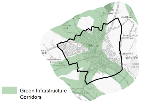
5.13.30 The town has a range of corridors and spaces that contribute towards its Green and Blue Infrastructure network. Key corridors include the valley of the River Aire (a regionally important corridor), the Leeds and Liverpool Canal running along the southern edge of the town, Silsden Beck that flows north to south from Silsden Reservoir, through the local wildlife site and the town centre to join the River Aire, and Bracken Hill Ghyll that flows from the north west of the town to join Silsden Beck. The canal, in particular, plays an important role in leisure, recreation and tourism. The GI network is illustrated in Figure 6 below.
Figure 6: Green Infrastructure Corridors
5.13.31 Silsden has several biodiversity designations that are located within and surrounding the town in the form of Local Wildlife Sites (LWS) and a Local Geological Site (LGS). The Leeds and Liverpool Canal LWS runs through the southern edge of the town extending to the south east and west, whilst Brackenhill Ghyll LWS and Throstle Nest LGS are to the north west. Silsden Reservoir LWS is to the north with Swartha Wood LWS to east. The South Pennine Moors (Phase 2) SPA and SAC (and SSSI) are located around 2km to the east, placing the eastern part of the Silsden within the 2.5km buffer zone with the remainder being within 7km buffer.
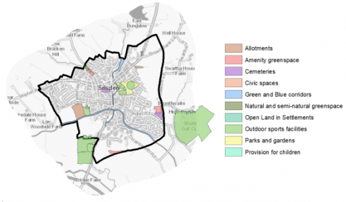
5.13.32 Silsden has 28 open spaces which total around 54ha of land. Key sites within the town include Silsden Park, Silsden Allotments, St James' Churchyard, Silsden Sports Ground, the Leeds and Liverpool Canal, and Howden Cemetery. The Open Space Assessment (2020) highlights that there are notable deficits of certain types of open space, however existing provision is well distributed throughout the settlement. It is suggested that consideration should be given to increase provision of Natural and Semi-natural Greenspace and Parks and Gardens. The location and type of open space provision is shown on figure 7 below.
Figure 7: Silsden - Open Space Overview
5.13.33 Much of the land to south of Silsden forms part of the extensive flood plain of the River Aire, much of it is within Flood Zones 3 and 3b. The river is fed by a number fast flowing upland streams, one of which Silsden Beck flows through the town centre. There is a history of flooding from Silsden Beck.
Community Infrastructure – Education, Health and Utilities
5.13.34 In addition to the retail provision, described above, the town has a good range of community facilities and services to meet the day to day needs of the local population. This includes Silsden Town Hall, which incorporates the town's library and range of spaces for local groups and functions. There is also a post office, located on Kirkgate and a petrol station on Keighley Road as well as a Fire Station and three Places of Worship.
5.13.35 Silsden Primary School is located on two sites within the centre of the town (previously the Aire View Infant School and Hothfield Junior School). Both schools came together in 2017 to form a single primary school. The combined school has capacity for 630 pupils, however it is currently over-subscribed. Planning permission for granted for a new 3 from entry primary school (future-proofed to enable four form entry) and nursery was granted in June 2018 on land on the north eastern edge of the built up area. The new school will provide a four form entry school for 840 pupils with 40 place nursery.
5.13.36 The town does not have a secondary school. The nearest schools within Bradford district are found in Keighley – The Holy Family Catholic School, Oakbank School and University Academy Keighley. A number of children also travel across the local authority boundary into North Yorkshire to access South Craven School in the neighbouring settlement of Cross Hills. All secondary schools include 6th Form provision. These schools have capacity for 5,223 pupils. All three Keighley schools are currently under subscribed, whilst South Craven is oversubscribed. Pupil attainment levels at Key Stages 1 and 2 are the West Yorkshire and England averages, whilst for Key Stage 4 (GCSE), average scores are higher – 405.9 compared to 353.5 and 366.3 respectively.
5.13.37 Primary healthcare services are provided at Silsden Surgery. This is part of the Silsden & Steeton Medical Practice, which has 8 GPs and caters for 11,632 registered patients. Several of the GP surgeries/health centres in Keighley also include Silsden within their practice areas. The medical practice also includes a pharmacy. A further pharmacy is within the local centre. Acute health services are provided at Airedale General Hospital in Eastburn, around 1.5km to the south west. It provides a wide range of services including Accident & Emergency and Maternity. Figure 8 below shows the location of local schools and medical facilities in Silsden.
5.13.38 Average life expectancy at birth for Silsden residents is 78 for men and 83 for women, which is similar to the West Yorkshire and England averages. Healthy life expectancy is 65 for men and 67 for women. This is slightly higher than the West Yorkshire and national average.
Figure 8: Schools & Medical Facilities in Silsden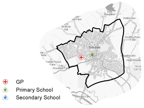
5.13.39 The town is served by the Marley Waste Water Treatment Works, owned and operated by Yorkshire Water.
5.13.40 When planning for the long-term development of Silsden, it is vital that new development is supported by the appropriate infrastructure. The capacity, quality and accessibility of services and facilities are all key components in ensuring people can enjoy living, working and visiting the area. The council will continue work with key infrastructure providers and others including the Local Education Authority, Clinical Commissioning Group and utilities providers to determine the impacts of future growth and development on local infrastructure capacity and provision. Further infrastructure details will be published through the Local Infrastructure Plan and as part of the Regulation 19 stage of the local plan.
|
Local Area Strategy & Plan - Silsden |
|
The key elements of the local area strategy for Silsden include:
|
(47) Consultation Question 112
Silsden Local Area Strategy
The Local Plan sets out a local area strategy for Silsden.
Q. Please provide any comments you may have on the area strategy?
If you have an alternative to the approaches undertaken, please provide further details and evidence in support.
Preferred Site Allocations and Site Pro Formas
5.13.41 The preferred housing site allocations are detailed below in Tables A. This table is subsequently followed by site pro formas for each preferred site allocation proving a summary of key site information and characteristics.
Table A: Silsden Housing Sites - Preferred Allocations
|
Site Ref |
Site Name |
Dwellings |
|
SI1/H |
North Dene Road |
43 |
|
SI2/H |
Bolton Road/Brown Bank Lane |
40 |
|
SI3/H |
Woodside Road |
146 |
|
SI4/H |
Sykes Lane |
145 |
|
SI5/HC* |
Keighley Road |
156 |
|
SI6/H |
Aire View Infant School, Elliot Street |
21 |
|
SI7/H |
Hothfield Infant School, Norton Street |
22 |
|
SI8/H |
Dradishaw Road |
7 |
|
Total |
580 |
*Site had outline permission at 31st March 2020, with detailed permission pending which has now been approved.
(12) Consultation Question 113
Silsden Site Allocations and Site Pro Formas
The Local Plan sets out a series of preferred site allocations. If you wish to make representations on any of the sites proposed, please provide site reference and feedback under this question.
If you wish to propose an additional or alternative site(s) to the preferred allocations listed, please also provide a plan with a red line and any further details in support.
[1] Where 1 is the most deprived and 30 is the least deprived.
[2] Universal Service Obligation (USO) - download speeds at or above 10Mbit/s and upload speeds at or above 1Mbit/s including non-matched records and zero predicted speeds
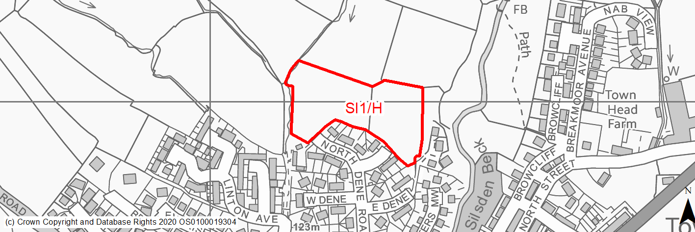
(27) SI1/H - North Dene Road
Site location
Local Growth Centre - Silsden
Ward
Craven
Site description
The site consists of two, sloping agricultural fields divided by a hedgerow and trees on the northern edge of Silsden. It is currently used for grazing.
Proposed Allocation
Housing
SHLAA referencce
SI/001
Indicative no. dwellings
43
Site area (Gross) (ha)
1.36
Ownership
Council
Delivery timescales
Developable (6-10 years)
Type (PDL/Greenfield)
Greenfield
Green Belt
No
Flood Zone
Flood Zone 1
Potential site access
Potential access points via existing field accesses from North Dene Road or Dene Grove.
Public Transport Accessibility
Bus: The nearest bus stops are located around 360m to the south on Bridge Street. These provide 2 services per hour to Keighley (westbound) and Ilkley (1 per hour) & Leeds Bradford Airport (1 per hour) (eastbound). There are also a limited/less frequent service between Keighley & Silsden via Steeton and Airedale Hospital. All bus services stop adjacent to Steeton & Silsden railway station to provide access to rail services. (Services 62 & 903).
Rail: Steeton & Silsden railway station is located around 2.1km (in a straight line)/2.3km (via quickest walking route) (circa 28 mins) to the south. This provides 8 services per hour to Leeds (2 per hour), Bradford Forster Square (2 per hour) and Skipton (4 per hour).
Sustainability Appraisal
Development at this site would be unlikely to result in a significant effect, either positive or negative, on any SA Objective.
Minor positive effects were predicted for all socio-economic themed SA Objectives due to the benefits of new residential development for the local economy as well as the location of the site in relation to transport links, local services and amenities, education facilities and employment areas.
Minor adverse effects were predicted for a range of natural environment themed SA Objectives, primarily as a result of the impacts of new development on a 100% greenfield site which adjoins TPO woodland. Additionally, a small, unnamed stream falls just within the site’s north-western perimeter, the water quality of which could be impacted by the construction and occupation of this site.
Habitats Regulations Assessment
Part of this site falls within 2.5km of the South Pennine Moors SPA/SAC a HRA must be undertaken to ensure there are no significant effects on these protected sites in terms of impact on supporting habitat which might be functionally linked to the SPA and recreational pressures. Developments within these zones must comply with Policy SP11; an SPD is being produced to provide further guidance.
Green Belt
N/A – Site not within the Green Belt.
Constraints and Opportunities
• This is a greenfield site within the settlement boundary for Silsden, at northern edge of the built up area. It us currently in agricultural use.
• A footpath runs adjacent to the western, whilst there are water courses along the eastern and western edges.
• It is within the 2.5km buffer of the SPA/SAC.
Development considerations
• Bird survey may be required.
• Ecological survey will be required to assess and mitigate potential impacts.
• Sensitive design and layout required to take account of surrounding trees, hedgerows and watercourse.
• Flood risk assessment will be required (site is larger than 1ha).
• Access available from North Dene Road.
Conclusion/Summary
This is a sustainable site within the settlement boundary for Silsden, on the northern edge of the settlement. It will deliver an estimated 43 dwellings.
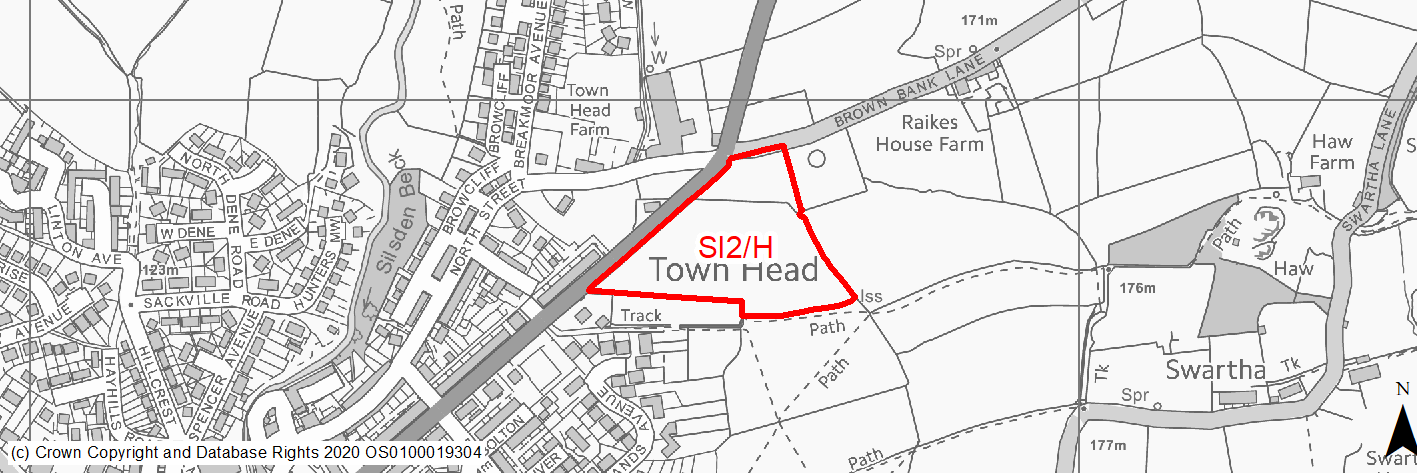
(27) SI2/H - Bolton Road Brown Bank Lane
Site location
Local Growth Centre - Silsden
Ward
Craven
Site description
The site consists of of two , gently sloping, agricultural fields off Bolton Road on the north eastern edge of Silsden. It slopes gently from east to west.
Proposed Allocation
Housing
SHLAA referencce
SI/004a
Indicative no. dwellings
40
Site area (Gross) (ha)
2.1
Ownership
Private
Delivery timescales
Developable (6-10 years)
Type (PDL/Greenfield)
Greenfield
Green Belt
No
Flood Zone
Flood Zone 1
Potential site access
Existing field access is available from Bolton Road, however an appopriate access point will need to be determined.
Public Transport Accessibility
Bus: Most of site nearest to the urban area is within 400m walking distance to bus stop. The nearest bus stops are located around 175m to the west on Bolton Road. These provide 2 services per hour to Keighley (southbound) and Ilkley (1 per hour) & Leeds Bradford Airport (1 per hour) (northbound). All bus services stop adjacent to Steeton & Silsden railway station to provide access to rail services. (Service 62).
Rail: Steeton & Silsden railway station is located around 1.9km (in a straight line)/2.3km (via quickest walking route) (circa 28 mins) to the south. This provides 8 services per hour to Leeds (2 per hour), Bradford Forster Square (2 per hour) and Skipton (4 per hour).
Sustainability Appraisal
Development at this site would be unlikely to result in a significant effect, either positive or negative, on any SA Objective.
Minor positive effects were predicted for all socio-economic themed SA Objectives due to the benefits of new residential development for the local economy as well as the location of the site in relation to transport links, local services and amenities, education facilities and employment areas.
Minor adverse effects were predicted for a range of natural environment themed SA Objectives, primarily as a result of the impacts of new development on a 100% greenfield site which contains a small area of TPO woodland as well as adjoining it on the north and south sides. The site is in close proximity to four Grade II Listed Buildings, the setting of one may be adversely affected by the development due to the topography.
Additionally, a small, unnamed stream falls just within the site’s southern perimeter, the water quality of which could be impacted by the construction and occupation of this site.
Habitats Regulations Assessment
This site falls within 2.5km of the South Pennine Moors SPA/SAC a HRA must be undertaken to ensure there are no significant effects on these protected sites in terms of impact on supporting habitat which might be functionally linked to the SPA and recreational pressures. Developments within these zones must comply with Policy SP11; an SPD is being produced to provide further guidance.
Green Belt
N/A – Site not within the Green Belt.
Constraints and Opportunities
• This is a greenfield site within the settlement boundary for Silsden, at the north eastern edge of the built up area. It is currently in agricultural use.
• A public transport corridor runs along the western boundary.
• There is potential for landscape impacts due to its location.
• An appropriate access solution needs to be identified.
• A TPO tree and areas of TPO woodland are present.
• It is also within a Green Infrastructure corridor and within the 2.5km buffer of the SPA/SAC.
Development considerations
• A bird survey will be required due to its location with SPA/SAC Zone B (2.5km buffer).
• Sensitive design and layout required to mitigate landscape impacts.
• Ensure a biodiversity net gain.
• Investigate a suitable vehicluar and pedestrian access from the adjacent highway network.
• Flood risk assessment required (site larger than 1ha).
Conclusion/Summary
This is a sustainable site with the settlement boundary for Silsden with access to local services and facilities as well as frequent public transport services. It will deliver an estimate 40 dwellings, however will require sensitive design and layout to mitigate landscape impacts, as well as an appropriate access solution.
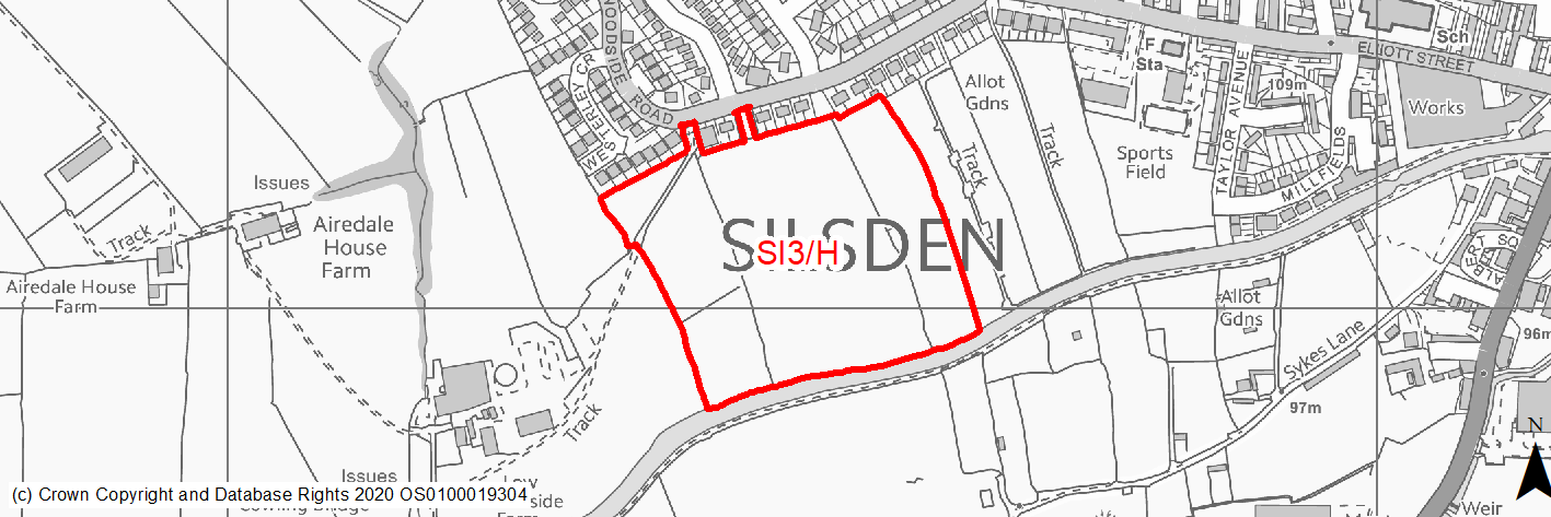
(39) SI3/H - Woodside Road
Site location
Local Growth Centre - Silsden
Ward
Craven
Site description
The site consists of three agricultural fields, partially divided by hedges and trees, within the settlement boundary. It slopes from north to south towards the Leeds & Liverpool Canal.
Proposed Allocation
Housing
SHLAA referencce
SI/008
Indicative no. dwellings
146
Site area (Gross) (ha)
5.56
Ownership
Private
Delivery timescales
Developable (6-10 years)
Type (PDL/Greenfield)
Greenfield
Green Belt
No
Flood Zone
Flood Zone 1
Potential site access
Two access points available from Woodside Road. It should be noted that the western-most one also provides access to Low Woodside Farm.
Public Transport Accessibility
Bus: The nearest bus stops are located around 20m to the north of the site on Woodside Road. These provide 2 services per hour to Keighley (eastbound) and Ilkley/Leeds Bradford Airport (westbound) (Service 62). All bus services stop adjacent to Steeton & Silsden railway station to provide access to rail services.
Rail: Steeton & Silsden railway station is located around 1.1km (in a straight line)/2.2km (via quickest walking route) (circa 30 mins) to the south. This provides 8 services per hour to Leeds (2 per hour), Bradford Forster Square (2 per hour) and Skipton (4 per hour).
Sustainability Appraisal
The site could deliver a major positive effect for residents on the health SA Objective as a result of being within the target distances for all necessary health facilities.
Minor positive effects were predicted for all other socio-economic themed SA Objectives due to the benefits of new residential development for the local economy as well as the location of the site in relation to transport links, local services and amenities, education facilities and employment areas.
No major adverse effects have been predicted for the site, but minor adverse effects were predicted for a range of natural environment themed SA Objectives, primarily as a result of the impacts of new development on a 100% greenfield site. The site is adjacent to the Leeds Liverpool Canal Conservation Area, the setting of which could be adversely affected by the development, and to the Leeds and Liverpool Canal, meaning very careful consideration is required around protecting water quality.
Habitats Regulations Assessment
This site falls within 7km of the South Pennine Moors SPA/SAC. A HRA must be undertaken to ensure there are no significant effects on these protected sites. Developments within these zones must comply with Policy SP11; a SPD is being produced to provide further guidance.
Green Belt
N/A – Site not within the Green Belt.
Constraints and Opportunities
• This is a sloping greenfield site within the settlement boundary for Silsden, on the western edge of the built up area. It is currently in agricultural use.
• An opportunity exists for access to the countryside via an adjacent footpath.
• It is adjacent to the Leeds & Liverpool Canal which is designated as a Conservation Area as well as Local Wildlife Site.
• Several TPO trees and two areas of TPO woodland as well as hedgerows are present within the site.
• There are potential landscape and visual issues due to its location.
• It is within a Green Infrastructure corridor and within the 7km buffer of the SPA/SAC.
Development considerations
• Sensitive layout and design will be required to address and mitigate landscape and visual impacts as well as those on the Conservation Area and Local Wildlife.
• An ecological assessment will be required.
• Access is available from Woodside Road, however consideration should be given to impacts and mitigation measure at the junction of Elliott Street/Keighley Road/Clogg Bridge.
• Flood risk assessment will be required (site larger than 1ha).
Conclusion/Summary
This is an appropriate site within the settlement boundary for Silsden with access to local services and facilities include infant/junior schools and medical centre. It is also adjacent to a public transport route with a good services to town centre and neighbouring towns. It will deliver an estimated 146 dwellings, however will senstive design, layout and density together with appropriate mitigation measures to address landscape and visual impacts as well as the setting of the adjacent Conservation Area and Local Wildlife Site.
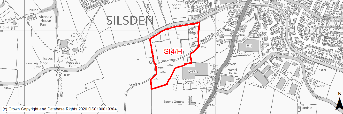
(26) SI4/H - Sykes Lane
Site location
Local Growth Centre - Silsden
Ward
Craven
Site description
The site consists of a mixture of small agricultural fields and small holdings/allotments, located to the south of the Leeds & Liverpool Canal.
Proposed Allocation
Housing
SHLAA referencce
SI/013
Indicative no. dwellings
145
Site area (Gross) (ha)
5.52
Ownership
Private
Delivery timescales
Developable (6 to 10 years)
Type (PDL/Greenfield)
Greenfield
Green Belt
No
Flood Zone
Flood Zone 1
Potential site access
No access points available. Only access would need to be via adjacent site (SI/020) from Keighley Road.
Public Transport Accessibility
Bus: Site is located within 400m of bus route 62. The nearest bus stops are located around 190m & 200m to the east, and 250m & 260m to the south east, on Keighley Road. These provde 2 services per to Keighley (southbound), and Ilkley (1 per hour)/Leeds Bradford Airport (1 per hour) (northbound). There is also a limited/less frequent service between Keighley & Silsden via Steeton and Airedale Hospital. All bus services stop adjacent to Steeton & Silsden railway station to provide access to rail services. (Services 62 & 903).
Rail: Steeton & Silsden railway station is located around 860m (in a straight line)/1.5km (via quickest walking route) (circa 18 mins) to the south. This provides 8 services per hour to Leeds (2 per hour), Bradford Forster Square (2 per hour) and Skipton (4 per hour).
Sustainability Appraisal
The site could deliver a major positive effect for residents on the health SA Objective as a result of being within the target distances for all necessary health facilities.
A major adverse effect arises for the climate change resilience SA objective due to the site falling partially within the active flood zones FZ2 and FZ3. More detailed flood risk assessments would likely be required for the site.
Minor positive effects were predicted for a range of socio-economic themed SA Objectives due to the benefits of new residential development for the local economy as well as the location of the site in relation to transport links, local services and amenities, and education facilities.
Minor adverse effects were predicted for a range of natural environment themed SA Objectives, primarily as a result of the impacts of new development on a predominantly greenfield site containing hedgerows and trees. The site is adjacent to the Leeds Liverpool Canal Conservation Area, the setting of which could be adversely affected by the development, and to the Leeds and Liverpool Canal, meaning very careful consideration is required around protecting water quality.
Habitats Regulations Assessment
This site falls within 7km of the South Pennine Moors SPA/SAC. A HRA must be undertaken to ensure there are no significant effects on these protected sites. Developments within these zones must comply with Policy SP11; a SPD is being produced to provide further guidance.
Green Belt
N/A – Site not within the Green Belt.
Constraints and Opportunities
• This is a mainly level, greenfield site within the settlement boundary for Silsden, on the south western edge of the built up area. It is currently used for agricultural purposes including small holdings and animal pens.
• It is adjacent to the Leeds & Liverpool Canal which is designated as a Conservation Area as well as a Local Wildlife Site.
• It is within a Green Infrastructure corridor and within the 7km buffer of the SPA/SAC.
Development considerations
• Sensitive layout and design will be required to address and mitigate limpacts on the Conservation Area and Local Wildlife.
• An ecological assessment will be required.
• Flood risk assessment will be required (site larger than 1ha).
• Access should be investigated.
• Mitigation any impacts on Skyes Lane (identified in emerging Neighbourhood Plan as a key feature/protected lane).
• Loss of allotments should should be addressed.
Conclusion/Summary
This is an appropriate site within the settlement boundary for Silsden with access to local services and facilities. It will deliver an estimated 145 dwellings, however will senstive design, layout and density together with appropriate mitigation measures to address impacts on the setting of the adjacent Conservation Area and Local Wildlife Site. An access solution will also need to be identiifed.
(21) SI5/HC - Keighley Road
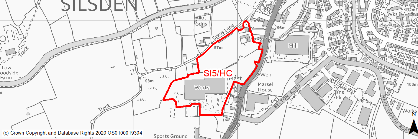
Site location
Local Growth Centre - Silsden
Ward
Craven
Site description
This site consists of the former Riverside works factory car park and other associated land.
Proposed Allocation
Housing
SHLAA referencce
SI/020
Indicative no. dwellings
156
Site area (Gross) (ha)
4.51
Ownership
Private
Delivery timescales
Deliverable (0-5 years) and Developable (6-10 years)
Type (PDL/Greenfield)
PDL
Green Belt
No
Flood Zone
Flood Zone 1 (20%), Flood Zone 2 (80%) and Flood Zone 3 (80%).
Potential site access
Access to be taken off Keighley Road.
Public Transport Accessibility
Public transport accessibility has been taken into account as part of the planning application process.
Sustainability Appraisal
The site could deliver a major positive effect for residents on the health SA Objective as a result of being within the target distances for all necessary health facilities.
A major adverse effect arises for the climate change resilience SA objective due to the site falling almost entirely within the active flood zones FZ2 and FZ3, and containing limited areas at high risk of surface water flooding. More detailed flood risk assessments would likely be required for the site.
Minor positive effects were predicted for a range of socio-economic themed SA Objectives due to the benefits of new residential development for the local economy as well as the location of the site in relation to transport links, local services and amenities, education facilities and employment areas.
Minor adverse effects were predicted for a range of natural environment themed SA Objectives, primarily as a result of the impacts of new development on a partially greenfield site containing hedgerows and trees. The site is adjacent to both the Silsden and Leeds Liverpool Canal Conservation Areas, the settings of which could be adversely affected by the development, and to the Leeds and Liverpool Canal. Additionally, the site is 20m west of Silsden Beck and the construction and occupation of this site could impact the water quality here.
Habitats Regulations Assessment
This site falls within 7km of the South Pennine Moors SPA/SAC a HRA must be undertaken to ensure there are no significant effects on these protected sites in terms of recreational pressures. Developments within these zones must comply with Policy SP11; an SPD is being produced to provide further guidance.
Green Belt
N/A – Site not within the Green Belt
Constraints and Opportunities
• Relevant constraints and opportunities have been considered as part of the planning application process
Development considerations
• Relevant development considerations have been taken into account as part of the planning application process.
Conclusion/Summary
This site has outline planning permission for 156 dwellings (16/03804/MAO approved on 26.11.18).
(17) SI6/H - Aire View Infants, Elliot Street
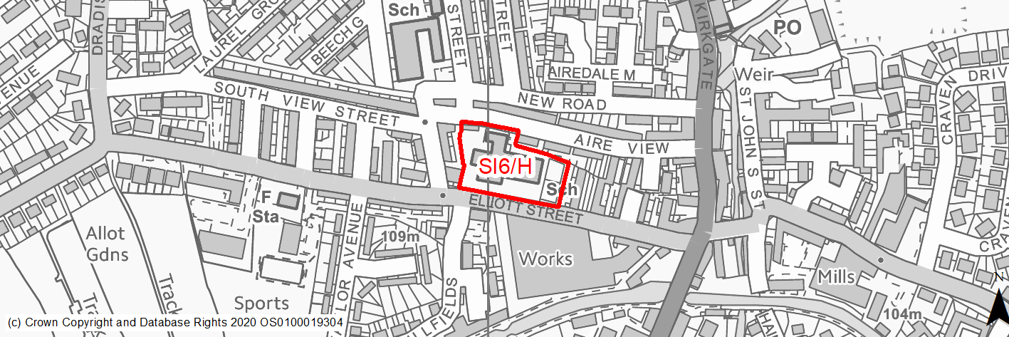
Site location
Local Growth Centre - Silsden
Ward
Craven
Site description
The site consists of the existing buildings and grounds of Silsden Primary School (Aire View Infants), to west of the town centre. It is currently in use.
Proposed Allocation
Housing
SHLAA referencce
SI/023
Indicative no. dwellings
21
Site area (Gross) (ha)
0.49
Ownership
Council
Delivery timescales
Developable (6-10 years)
Type (PDL/Greenfield)
PDL
Green Belt
No
Flood Zone
Flood Zone 1
Potential site access
From Elliott Street or Aire View. Exact point will depend nature, scale and layout of any future development.
Public Transport Accessibility
Bus: The nearest bus stops are located around 50m & 75m to the east of the site on Elliott Street. These provide 2 services per hour to Keighley (eastbound) and Ilkley/Leeds Bradford Airport (westbound) (Service 62). All bus services stop adjacent to Steeton & Silsden railway station to provide access to rail services.
Rail: Steeton & Silsden railway station is located around 1.4km (in a straight line)/1.6km (via quickest walking route) (circa 21 mins) to the south. This provides 8 services per hour to Leeds (2 per hour), Bradford Forster Square (2 per hour) and Skipton (4 per hour).
Sustainability Appraisal
No significant adverse effects have been predicted for SI/023. Minor adverse effects have been predicted for air quality and water resources SA Objectives, as has been done for most sites. The site is well situated in terms of providing residents with good access to key services, facilities, and amenities, with particularly good access to health facilities. It is unclear if development at the site would deliver an enhancement to the setting of the nearby Conservation Area.
Habitats Regulations Assessment
This site falls within 7km of the South Pennine Moors SPA/SAC. A HRA must be undertaken to ensure there are no significant effects on these protected sites. Developments within these zones must comply with Policy SP11; a SPD is being produced to provide further guidance.
Green Belt
N/A – Site not within the Green Belt.
Constraints and Opportunities
• This is a previously developed site within the built up area of Silsden. It is currently in use as an infants school, which is due to be replaced by a new facility elsewhere in the settlement.
• The site is close to the local services and facilities as well as public transport services.
• It is adjacent to the Leeds and Liverpool Canal Conservation Area, whilst the school building may be of historic interest, whilst bats may be present.
• It is within the 7km buffer of the SPA/SAC.
Development considerations
• Consideration should be given to retention/conversation of the existing building.
• Investigate and mitigate potential impacts on setting of ajdacent Conservation Area.
• Access should be investigated, however consideration should be given to impacts and mitigation measure at the junction of Elliott Street/Keighley Road/Clogg Bridge.
Conclusion/Summary
This is a sustainable site within the built up area of Silsden, with good access to local services and facilities including a medical centre and shops. It is also on a public transport route with a good service to neighbouring towns. It will deliver an estimated 21 dwellings.
(21) SI7/H - Hothfield Junior School, Norton Street
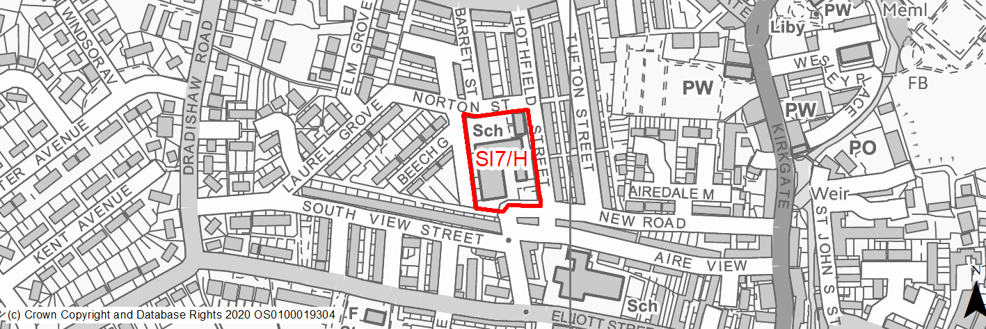
Site location
Local Growth Centre - Silsden
Ward
Craven
Site description
The site consists of the existing buildings and grounds of Silsden Primary School (Aire View Infants), to west of the town centre. It is currently in use.
Proposed Allocation
Housing
SHLAA referencce
SI/024
Indicative no. dwellings
22
Site area (Gross) (ha)
0.52
Ownership
Council
Delivery timescales
Developable (6-10 years)
Type (PDL/Greenfield)
PDL
Green Belt
No
Flood Zone
Flood Zone 1
Potential site access
From Norton Street or Hothfield Street. Exact point will depend nature, scale and layout of any future development.
Public Transport Accessibility
Bus: The nearest bus stops are located around 190m & 200m to the south east of the site on Elliott Street. These provide 2 services per hour to Keighley (eastbound) and Ilkley/Leeds Bradford Airport (westbound) (Service 62). All bus services stop adjacent to Steeton & Silsden railway station to provide access to rail services.
Rail: Steeton & Silsden railway station is located around 1.5km (in a straight line)/1.8km (via quickest walking route) (circa 24 mins) to the south. This provides 8 services per hour to Leeds (2 per hour), Bradford Forster Square (2 per hour) and Skipton (4 per hour).
Sustainability Appraisal
No significant adverse effects have been predicted for SI/024. Minor adverse effects have been predicted for air quality and water resources SA Objectives, as has been done for most sites. The site is well situated in terms of providing residents with good access to key services, facilities, and amenities, with particularly good access to health facilities. It is unclear if development at the site would deliver an enhancement to the setting of the nearby Conservation Area.
Habitats Regulations Assessment
This site falls within 7km of the South Pennine Moors SPA/SAC. A HRA must be undertaken to ensure there are no significant effects on these protected sites. Developments within these zones must comply with Policy SP11; a SPD is being produced to provide further guidance.
Green Belt
N/A – Site not within the Green Belt.
Constraints and Opportunities
• This is a previously developed site within the built up area of Silsden. It is currently in use as a junior school, which is due to be replaced by a new facility elsewhere in the settlement.
• The site is close to the local services and facilities as well as public transport services.
• Bats may be present.
• It is within the 7km buffer of the SPA/SAC.
Development considerations
• Consideration should be given to retention/conversation of the existing building.
• Access should be investigated, however consideration should be given to impacts and mitigation measure at the junction of Elliott Street/Keighley Road/Clogg Bridge.
Conclusion/Summary
This is a sustainable site within the built up area of Silsden, with good access to local services and facilities including a medical centre and shops. It is close to a public transport route with a good service to neighbouring towns. It will deliver an estimated 21 dwellings.
(17) SI8/H - Dradishaw Road, Silsden
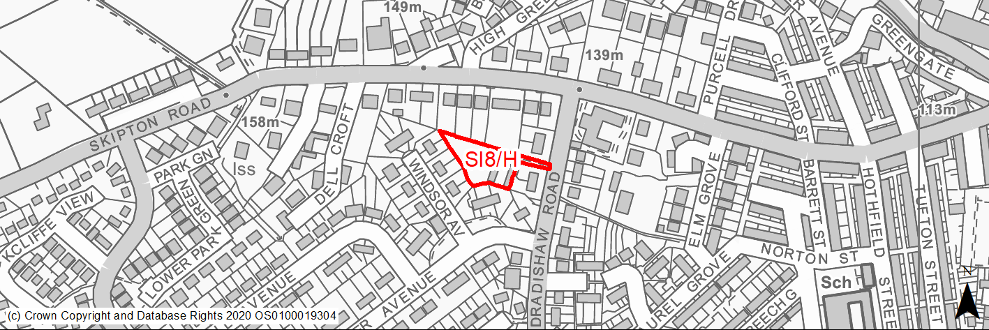
Site location
Local Growth Centre - Silsden
Ward
Craven
Site description
The site consists of an area of open amenity/green space with benches and trees. Part of the site was previously occupied by lock up garages.
Proposed Allocation
Housing
SHLAA referencce
SI/027
Indicative no. dwellings
7
Site area (Gross) (ha)
0.2
Ownership
Private
Delivery timescales
Deliverable (0-5 years)
Type (PDL/Greenfield)
90% Greenfield, 10% PDL
Green Belt
No
Flood Zone
Flood Zone 1
Potential site access
Existing access available from Dradishaw Road.
Public Transport Accessibility
Bus: The nearest bus stop is site is around 45m & 90m to the north on Dradishsaw Road & Skipton Road respectively. The former provides a limited services to/form Keighley via Steeton and Airedale Hospital, whilst the latter provides 2 services per hour to Keighley (westbound) and Ilkley (1 per hour)/Leeds Bradford Airport (eastbound.) All bus services stop adjacent to Steeton & Silsden railway station to provide access to rail services. (Services 62 & 903).
Rail: Steeton & Silsden railway station is located around 1.6km (in a straight line)/2.2km (via quickest walking route) (circa 27 mins) to the south. This provides 8 services per hour to Leeds (2 per hour), Bradford Forster Square (2 per hour) and Skipton (4 per hour). The form t within 400m of 1/2 hourly bus service but is on route of service 903 which offers buses at peak times to train station.
Sustainability Appraisal
No significant adverse effects have been predicted for SI/027. The site is on greenfield and could potentially result in minor adverse effects on natural environment themed SA Objectives. The site is outside the target distance of schools, but provides generally good access to all other key services and amenities, including bus links, jobs, and shops with particularly good access to health facilities.
Habitats Regulations Assessment
This site falls within 7km of the South Pennine Moors SPA/SAC. A HRA must be undertaken to ensure there are no significant effects on these protected sites. Developments within these zones must comply with Policy SP11; a SPD is being produced to provide further guidance.
Green Belt
N/A – Site not within the Green Belt.
Constraints and Opportunities
• This is a small, greenfield site within the existing built up area of Silsden and is in an established residential area. Part of the site was previously occupied by garages.
• A number of trees and an area of TPO woodland is present within the site.
• Access is available Dradishaw Road.
• The site is currently the subject of a pending planning application for residential development (7 dwellings).
Development considerations
• Retention of existing trees including TPO woodland within design and layout.
• Access available, however further assessment will be required.
• Mitigation required for the loss of open space.
Conclusion/Summary
This is a sustainable site within the built up area of Silsden, with good access to local services and facilities including a medical centre and shops. It is close to a public transport route with a good service to neighbouring towns. It will deliver an estimated 7 dwellings, however it requires sensitive design and layout to take account of existing trees and impact on the surrounding area.