
Draft Bradford District Local Plan - Preferred Options (Regulation 18) February 2021
Harden
Introduction
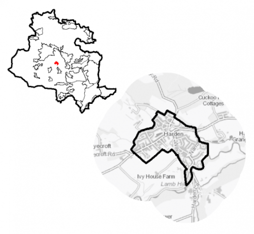
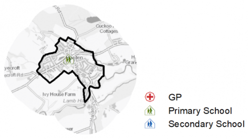
5.21.1 Harden is a small village which is situated in moorland between Bingley, Cullingworth, Keighley and Wilsden. The B6429 Harden Road/Long Lane runs through the centre of the village and the St Ives country park estate is located directly adjacent to the village on its eastern edge. It is one of nine settlements located in the South Pennine Towns and Villages sub-area. Harden falls within the Shipley Parliamentary Constituency and within the Bingley Rural Ward.
Figure 1: Location Plan
5.21.2 Harden has a population of 1,507 and a high percentage of this (58.6%) falls within the working age category (16-64). This is a slightly lower proportion compared to the West Yorkshire average (62.8%). This is partly due to the much higher percentage of over 65s living in Harden, accounting for 28.4% of the population. It will be important to consider the needs of a growing, older population over the lifetime of the plan. The statistics also show a smaller proportion of younger people living in village (13%) which again, needs to be factored into future planning and its implications for service provision.
5.21.3 The ethnic composition of Harden is primarily made up of people who identify themselves as White British - accounting for 97.1%. This is notable higher than the West Yorkshire average, but is similar to other smaller rural settlements in the District.
Planning for Prosperity
5.21.4 The Local Plan settlement hierarchy identifies Harden as one of Bradford district's 11 Local Service Centres. This means that it will see a smaller scale of development, comprising both market and affordable housing, as well as the protection of its local centre to help ensure the continued provision of economic activity in the area.
5.21.5 Harden is in the 10% least deprived areas of England according to the Indices of Multiple Deprivation (2019).
Economy and Employment
5.21.6 Economic activity rates are relatively positive with 72.3% of the resident population economically active compared to the West Yorkshire average (68.5%), and of those there is a slightly higher proportion who are classed as self-employed. Average household income at £43,700 is also above the West Yorkshire average (£38,499), but is similar to other smaller settlements within the District. The main employment sectors that the residents of Harden work in include: retail, education, and health and social work.
5.21.7 There are limited employment opportunities within the village itself, with many residents commuting out to larger settlements to access work. Key employment provision in the village is centred around the retail and service sector, particularly the Primary School and just outside the village, Woodbank Garden Centre.
5.21.8 Business Register and Employment Survey (BRES) data indicates that the three largest industry groups by workforce jobs (all people in employment) are: education, retail industry, and construction.
5.21.9 The local plan does not seek to specifically allocate employment land within this Local Service Centre, but the plan is supportive of appropriately sited and scaled economic growth and diversification within the Pennine Towns and Villages.
Retail
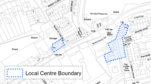
5.21.10 The retail offer in Harden is limited. The 2019 Retail and Leisure Study indicates that there are just nine units split over two clusters. Six of these units are located on either side of Wilsden Road at the junction with Harden Road, and include two convenience stores, one of which incorporates the Post Office. Within this cluster there is also a pharmacy and takeaway. There are also three units located on Long Lane, one of which is occupied by the Fleece public house. The Retail Study suggests that this is a stable local centre that continues to provide for the community's everyday needs. Figure 2 shows the boundary of the Local Centre.
Figure 2: Harden Local Centre
Transport and Access
5.21.11 Transport connections are focussed around the B6429 Harden Road / Long Lane which runs through the centre of Harden providing direct access to the Principal town of Bingley. Car ownership in the village is very high with 91% of households having at least one car. This is notably higher than the West Yorkshire average and reflects the rural nature of the settlement with limited public transport options and a smaller range of retail outlets and facilities, meaning residents often travel to the nearest larger towns to access such services.
5.21.12 Harden is served by three bus services. Two of which provide a half-hourly service to Bingley and Bradford (616 and 619 First Buses). The K17/K19 Keighley Jet bus service (Keighley Bus Company, Transdev Blazefield) provides a two-hour service connecting Harden to Cullingworth, Bingley and Keighley.
5.21.13 The nearest railway station is located at Bingley around 3km to the east. Trains from this station run through to Bradford and Leeds, Keighley and Skipton, allowing for connections to other larger towns and cities.
5.21.14 There are numerous footpaths leading out from the village into the countryside and connecting with the wider public rights of way network, providing opportunities for walking and cycling.
5.21.15 In relation to digital accessibility, average broadband download speed in Harden is around 28 megabytes per second which is below the West Yorkshire average of 44.57. There are no properties where speeds are below the Universal Service Obligation (USO)[1].
Planning for Homes
5.21.16 There are 714 dwellings within the settlement area. A large proportion of these properties are owner occupied (87%) which is notably higher than the West Yorkshire average (63%). The majority of the remaining dwellings are in private rented tenure (10%, which is lower than the West Yorkshire average (15%).
5.21.17 Harden has a good number of detached (41.3%) and semi-detached (26.2%) properties, many of which are located on suburban type extensions to the village which have occurred over the latter half of the twentieth century. Around the historic core of the settlement the main house type consists of terraced cottages (29.3%).
5.21.18 The average house price (all types) in Harden is £221,882, which is notably higher than the West Yorkshire average of £183,194. Detached properties are of similar prices to the West Yorkshire average, semi-detached properties are lower than the average, and terraced properties are notably higher. Figure 3, below provides house price details for the various house types in Harden. There is a higher proportion of properties in the higher council tax bands and the settlement is in one of the more affluent areas of the District. There is a notable lack of affordable housing within the settlement.
Figure 3: Harden – House Prices
|
Average house price (all types of housing) (Land registry Sept-19 to August-20) |
Average house price (detached) (Land registry Sept-19 to August-20) |
Average house price (flats) (Land registry Sept-19 to August-20) |
||
|
£221,882 |
£305,167 |
|||
|
West Yorkshire average = £183,194 |
West Yorkshire average = £324,872 |
West Yorkshire average = £128,299 |
||
|
Average house price (semi-detached) (Land registry Sept-19 to August-20) |
Average house price (terraced) (Land registry Sept-19 to August-20) |
Households in Council Tax Band A (Valuation Office Agency (VOA) 2020) |
||
|
£172,800 |
£179,500 |
20 |
||
|
West Yorkshire average = £178,439 |
West Yorkshire average = £132,430 |
2.7% (West Yorkshire average = 43.1%) |
||
|
Households in Council Tax Band B (VOA 2020) |
Households in Council Tax Band C (VOA 2020) |
Households in Council Tax Band F-H (VOA 2020) |
||
|
120 |
160 |
180 |
||
|
16.2% (West Yorkshire average = 20.2%) |
21.6% (West Yorkshire average = 17.6%) |
24.3% (West Yorkshire average = 4.3%) |
5.21.19 The delivery of new housing is a key part of the development strategy for Harden. This will ensure that the housing needs of local people can be met, both in terms of market and affordable housing. New housing will also allow for the modest growth of the settlement, to attract new residents and to help sustain the provision of services and facilities.
5.21.20 Policy SP8 in the local plan sets out a minimum requirement of 60 dwellings to be delivered in Harden during the plan period. These will be delivered through a mix of committed sites (those under construction or which have planning permission but have not yet started) and allocations. Table 1 below sets out the housing position for Harden, which also includes the application of non-implementation or discount rates for planning permissions and allocations.
Table 1: Harden - Summary of Housing Requirement and Supply
|
Housing Target |
60 units |
|
Carried Forward Commitments |
13 |
|
Commitment Discounted by 10% |
12 |
|
Remaining Allocation Requirement |
48 |
|
Identified Allocations |
64 |
|
Allocations Discounted by 10% |
58 |
|
Total Supply Contribution from Allocations |
58 |
5.21.21 Once the commitments are discounted and removed from the supply, this leaves a residual allocation requirement of 48 units. The evaluated total site supply of housing units from the preferred allocation sites equates to 64 units, which is in turn discounted by 10% for non-implementation or under delivery, leaving a final allocation contribution of 58 units.
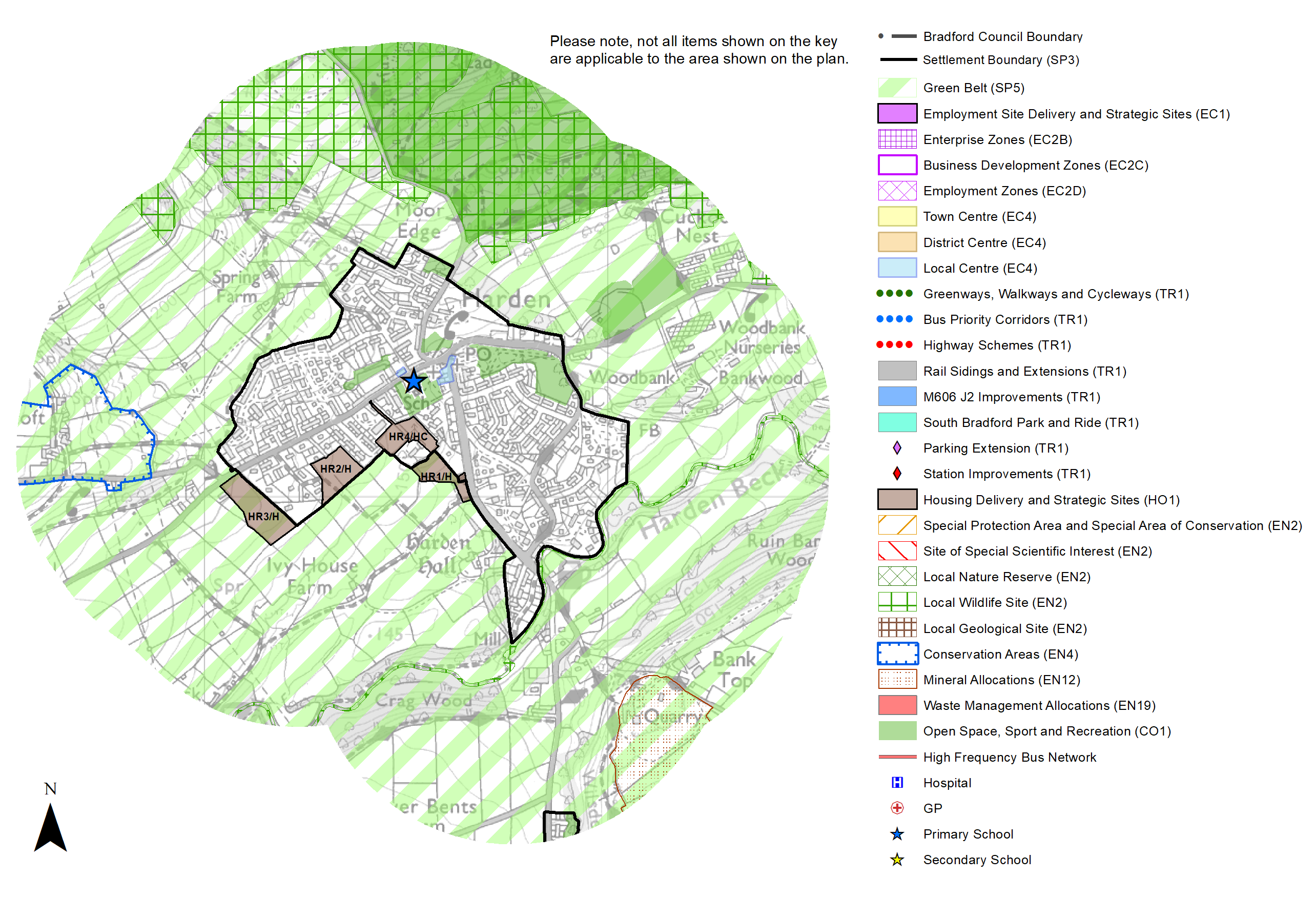
5.21.22 A portfolio of four sites have been identified as the preferred set of site options for Harden to meet the housing the requirement. These consist of a small garden-land site, a small greenfield site within the settlement, and two Green Belt sites. In delivering the target for new homes in Harden it has been necessary to make some changes to the adopted green belt. Policy SP5 sets out The Councils approach and justification for green belt releases to accommodate new development and lists the sites proposed for allocation which current lie within or partly within the green belt. Further information on these proposed allocations is set out in Table A and identified on the Policies Map and in the Site Pro Formas below, together with the local strategies map for each plan area. Development of site allocations should be in accordance with specified development guidelines and approximate site provision figures and all other relevant policies of the Local Plan. The Council will be supportive of additional proposals for new homes on additional small sites, particularly those that provide a redevelopment opportunity to bring forward land which has been previously used. Support will also be provided to developers who wish to redevelop larger sites and/or buildings for new homes not currently identified, subject to all relevant policies in the Local Plan.
Planning for Places and Communities
Green Belt, Natural Landscape and Historic Character
5.21.23 Harden is surrounded by the Green Belt which forms a tight boundary with the built-up area, leaving little room for further expansion of the settlement. There are four landscape character types which surround Harden. To the west is a large area of mixed upland pasture; to the north a small area of upland pasture; to the east a large area of parkland which encompasses the St Ives Country Park Estate; and to the south there is a small area of wooded valley. The Landscape Character Assessment indicates that all these character types, except for the upland pasture, are moderately sensitive to change. The upland pasture area is more sensitive to change with a moderately strong character, high historic continuity, and notably prominent and open aspect. The location of new development needs to consider the sensitivities of the landscape character in which it is situated.
5.21.24 There is no conservation area designated in Harden, but there are six Grade II listed buildings and structures within the settlement boundary and a number of other listed buildings directly adjacent to the settlement, including the Grade II* Harden Hall. The historic core of the settlement is focussed around the junction of Wilsden Road and Harden Road/Long Lane with a number of later ninetieth/early twentieth century buildings, including the Congregational Church, St Saviour's Church. Harden Primary School and a number of residential properties on Long Lane. In terms of other heritage designations, there are no scheduled monuments or known archaeological sites within the village itself, but there are a number of assets in the surrounding the countryside, as well as the Grade II listed Historic Park of St Ives directly adjacent to the settlement.
Green Infrastructure, Ecology, Open Space and Flood Risk
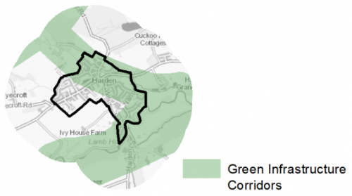
5.21.25 A large part of the settlement is within the District's Green Infrastructure corridors which connect important wildlife areas such as Harden Moor, St Ives, Crag Wood, North Wood and the Harden Beck/Mytholme Beck valleys. These corridors provide areas of multi-functional land which help to deliver benefits for biodiversity, reduce flood risk, provide routes for public rights of way, and connect important open spaces together and are identified in figure 4.
Figure 4: Green Infrastructure Corridors
5.21.26 There are no Local Wildlife Sites or Local Nature Reserves within the settlement limits of Harden, however, there are a number of sites which are adjacent to the village. There are also two Wildlife Habitat Networks running along the northern (St Ives) and southern edges of the settlement (Goitstock), which are made up of a mix of broadleaved semi-natural woodland, improved/semi-improved neutral grassland, bog/mire, heath, and acid grassland. The woodland separating Harden and Wilsden to the south is also designated ancient woodland.
5.21.27 The South Pennine Moors SPA/SAC are located around 4.5km to the north and therefore Harden falls within the 7km zone of this Internationally designated wildlife habitat. Within this zone new developments will need to contribute to measures to mitigate against the potential increased recreational impact of the increase in population.
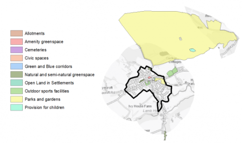
5.21.28 The Open Space Audit (2020) identifies 8 key open space sites within the village which cover an area of 5.39ha and includes Harden Memorial Hall Park and the Cricket and Football grounds. (Figure 5). Although the Audit indicates that there is a deficit of some types of open space within the settlement limits, there are other areas of open space in the immediate vicinity which partly make up for the lack of provision. Of particular note is the large country park estate of St Ives which sits adjacent to the settlement and offers a large greenspace environment for recreation. Any new development should look to increase the amount of amenity greenspace within the settlement and also consider the opportunities for providing additional allotment space, where possible.
Figure 5: Harden – Open Space Overview
5.21.29 Along the south east edge of the village runs Harden Beck and the land around this watercourse is within Flood Risk Zones 2 and 3. This only affects a very small part of the existing built-up area. A number of other smaller watercourses also flow through the centre of the village These are mainly culverted, but there are significant areas of the village which are identified as being vulnerable to surface water flooding.
Community Infrastructure – Education, Health and Utilities
5.21.30 Harden has a range of community facilities available to meet the day to day needs of local people. These include a small number of shops, a park and play area, sports grounds, Harden Memorial Hall (including Harden pre-school), the Congregational Church and St Saviour's Church, and a public house. For a more varied choice of facilities such as sport and leisure centres, libraries, a wider range of shops and financial services, residents would need to travel to nearby Bingley or further afield to Bradford or Keighley to access these facilities.
5.21.31 Harden Primary School is located in the centre of the village off Long Lane. It is a single form entry school and is part of the Exceed Academies Trust. It has a total capacity of 210 pupils. Secondary education provision has to be accessed outside of the village, with the nearest provision located in neighbouring Cullingworth at Parkside School, around 2.5km to the south west.
5.21.32 There is no GP provision in the village with residents having to travel to practices in nearby Wilsden (3km) and Cullingworth (2.5km) to access Primary Care Services. There is a pharmacy within the village allowing for the collection of prescriptions and the purchase of over the counter medicines. The nearest secondary (acute) care provision is located at Bradford Royal Infirmary, around 7km to the south east.
Figure 6: Harden – Schools
5.21.33 When planning for the long-term development of Harden, it is vital that new development is supported by the appropriate infrastructure. The capacity, quality and accessibility of services and facilities are all key components in ensuring people can enjoy living, working and visiting the area. The Council will continue work with key infrastructure providers and others including the Local Education Authority, Clinical Commissioning Group and utilities providers to determine the impacts of future growth and development on local infrastructure capacity and provision. Further infrastructure details will be published through the Local Infrastructure Plan and as part of the Regulation 19 stage of the local plan.
|
Local Area Strategy and Plan – Harden The key elements of the local area strategy for Harden include:
|
(12) Consultation Question 128
Harden Local Area Strategy
The Local Plan sets out a local area strategy for Harden.
Q. Please provide any comments you may have on the area strategy?
If you have an alternative to the approach undertaken, please provide further details and evidence in support.
Preferred Site Allocations and Site Pro Formas
5.21.34 The preferred housing site allocations are detailed below in Table A. This table is subsequently followed by site pro formas providing a summary of key site information and characteristics.
Table A: Housing - Preferred Allocations
|
Site Ref |
Site Name |
Dwellings |
|
HR1/H |
Chelston House |
15 |
|
HR2/H |
South Walk |
5 |
|
HR3/H |
Long Lane |
40 |
|
HR4/HC |
Long Lane |
4 |
|
Total |
64 |
Note: The sites labelled "HC" had outline planning permission at 1st April 2020.
(7) Consultation Question 129
Harden Site Allocations and Site Pro Formas
The Local Plan sets out the preferred site allocations for Harden. If you wish to make representations on the sites proposed, please provide feedback under this question.
If you wish to propose an additional or alternative site(s) to the preferred allocations listed, please also provide a plan with a red line and any further details in support.
[1] Universal Service Obligation (USO) - download speeds at or above 10Mbit/s and upload speeds at or above 1Mbit/s including non-matched records and zero predicted speeds
(12) HR1/H - Chelston House
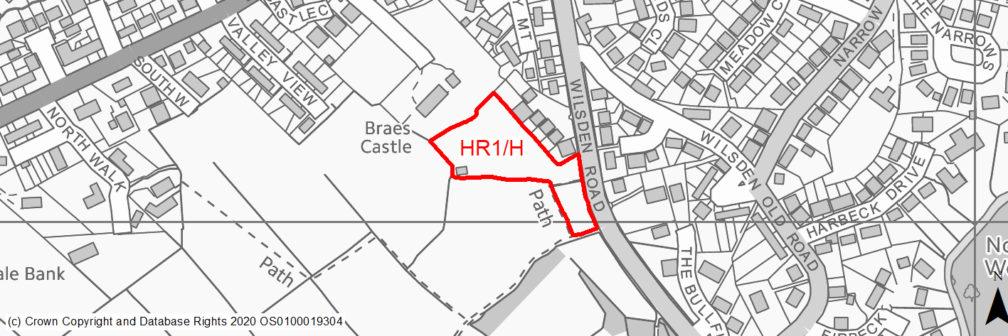
Site location
Local Service Centre - Harden
Ward
Bingley Rural Ward
Site description
This site is located on the south side of Harden and consists of a grassed piece of land which slopes gentle-moderate down hill from the north west to the south east. It is partially enclosed by the strong tree line along the south boundary. The site boundaries are made up of the rear gardens of properties on Chelston Park, a footpath, dry stone walls and a strong tree line/hedgerow.
Proposed Allocation
Housing
SHLAA referencce
HR/004
Indicative no. dwellings
15
Site area (Gross) (ha)
0.67
Ownership
Private
Delivery timescales
Developable (6-10 years)
Type (PDL/Greenfield)
Greenfield
Green Belt
Yes
Flood Zone
Flood Zone 1
Potential site access
Site can be accessed from from an existing access point off Wilsden Road. The access would need to be widened. Adequate visibility splays could be provided.
Public Transport Accessibility
Bus stop within 400m but services only every 30 mins.
Sustainability Appraisal
Development at this site would be unlikely to result in a significant effect, either positive or negative, on any SA Objective.
Minor positive effects were predicted for a range of socio-economic themed SA Objectives due to the benefits of new residential development for the local economy as well as the location of the site in relation to transport links, health and education facilities and employment areas. However, the local offering of services and amenities appears very limited so residents may have to travel way beyond the target distance.
No major adverse effects have been predicted for the site, but minor adverse effects were predicted for a range of natural environment themed SA Objectives, primarily as a result of the impacts of new development on a 100% greenfield and Green Belt site with adjacent TPO woodland and trees. There is a very limited extent of land at medium risk of surface water flooding, but it is expected this would be avoided through the careful layout of the development.
Within 150m of the site is one Grade II* and four Grade II Listed Buildings; development at the site could have a minor adverse effect on the setting of these sensitive heritage assets.
Habitats Regulations Assessment
This site falls within 7km of the South Pennine Moors SPA/SAC. A HRA must be undertaken to ensure there are no significant effects on these protected sites. Developments within these zones must comply with Policy SP11; a SPD is being produced to provide further guidance.
Green Belt
Based on planning judgement the site has a moderate potential impact on the Green Belt.
• The site is located in a moderate Green Belt parcel.
• The site makes a moderate contribution to the purposes of including land in the Green Belt.
• The site has a moderate potential for sprawl and would have a moderate impact on the openness.
• The site presents an opportunity to create a slightly stronger boundary than the existing boundary.
Constraints and Opportunities
• The site is currently designated as Green Belt, and the site specific Green Belt assessment indicates that it has a moderate potential impact.
• Potential impact on the Grade II* Listed Harden Hall.
• The site would have a moderate impact on the landscape.
• The site is within a Green Infrastructure corridor and there are TPO trees along the eastern boundary.
• The site is located within the 7km buffer of the SPA/SAC.
Development considerations
• Provision of compensatory improvements to the surrounding Green Belt which may include enhancement of the existing rights of way adjacent to the site.
• A sensitively designed scheme, including appropriate screening and consideration of building heights and materials will be required to mitigate any impact on the nearby heritage assets and wider landscape.
• Vehicular and pedestrian access is available off Wilsden Road.
Conclusion/Summary
This is a sustainable site located adjacent to the settlement boundary and near to a number of local services and facilities including shops, a primary school and open space. It would deliver an estimated 15 dwellings and provide a suitable small extension to the village.
(7) HR2/H - South Walk
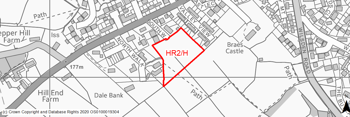
Site location
Local Service Centre - Harden
Ward
Bingley Rural Ward
Site description
This site is a relatively level, grassed agricultural field. It forms part of a wider expanse of agricultural land. The site is bounded on three sides by residential development and no defined boundary on the south side. There are a number of trees which run across the central portion of the site.
Proposed Allocation
Housing
SHLAA referencce
HR/005
Indicative no. dwellings
5
Site area (Gross) (ha)
0.91
Ownership
Private
Delivery timescales
Developable (11-15 years)
Type (PDL/Greenfield)
Greenfield
Green Belt
No
Flood Zone
Flood Zone 1
Potential site access
There is existing access to the site off South Walk. However, there are possible capacity issues as South Walk is narrow in width and two way traffic may be difficult to accommodate. Visibility splays from South Walk in to Long Lane may be difficult to achieve.
Public Transport Accessibility
Within 400m of a bus stop but very limited service.
Sustainability Appraisal
No significant adverse effects predicted for the site. Minor adverse effects have been predicted for most natural environment themed SA Objectives, primarily as a result of the impacts associated with development on a large greenfield site. The site is well located to provide residents with access to jobs, health facilities and local cultural offerings, with particularly good access to schools. The site has good access to bus stops along Wilsden Road. Access to some services is somewhat limited due to the nature of Harden, and residents may need to travel further afield into Bingley or Wilsden in order to access some services.
Habitats Regulations Assessment
This site falls within 7km of the South Pennine Moors SPA/SAC. A HRA must be undertaken to ensure there are no significant effects on these protected sites. Developments within these zones must comply with Policy SP11; a SPD is being produced to provide further guidance.
Green Belt
N/A – Site not within the Green Belt.
Constraints and Opportunities
• This site is accessed via South Walk which is a narrow road and this may limit the capacity of the site.
• The site is within a Green Infrastructure corridor and there are TPO trees along the western boundary.
• The site is located within the 7km buffer of the SPA/SAC.
Development considerations
• A highways assessment will be required to establish the access restrictions to the site.
• The design of the site should look to enhance the Green Infrastructure network.
Conclusion/Summary
This is a sustianable site located within the settlement boundary and close to nearby services and facilities including a primary school and shops. Due to the access restrictions it could deliver an estimated 5 dwellings.
(11) HR3/H - Long Lane
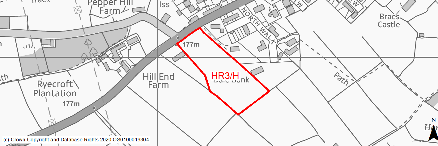
Site location
Local Service Centre - Harden
Ward
Bingley Rural Ward
Site description
This site consists of a single field, which currently used for grazing, is relatively level but slopes gentley downhill from North to South. The site forms a gap between the existing urban edge a detached property in the Green Belt. The site's boundaries are made up of dry stone walls, hedgerows and trees.
Proposed Allocation
Housing
SHLAA referencce
HR/006
Indicative no. dwellings
40
Site area (Gross) (ha)
1.36
Ownership
Private
Delivery timescales
Developable (11-15 years)
Type (PDL/Greenfield)
Greenfield
Green Belt
Yes
Flood Zone
Flood Zone 1
Potential site access
There is an existing farm access point off Long Lane. This would need to be widened and improved.
Public Transport Accessibility
Within 400m of a bus stop but very limited service.
Sustainability Appraisal
There are unlikely to be any significant effects, either positive or negative, on any SA Objective arising as a result of development at this site.
Minor positive effects were predicted for a range of socio-economic themed SA Objectives due to the benefits of new residential development for the local economy as well as the location of the site in relation to transport links, education facilities and employment areas. However, due to the location of the site access to health facilities is somewhat limited and residents may need to travel way beyond the target distance to access basic services and amenities.
As a large greenfield and Green Belt site adjacent to TPO woodland, the development has been predicted to result in minor adverse effects on most natural environment themed SA Objectives. A Grade II Listing Building adjoins the site’s north-western corner, and there is a second 40m west of the site, the settings of which could be adversely affected by the development.
Habitats Regulations Assessment
This site falls within 7km of the South Pennine Moors SPA/SAC. A HRA must be undertaken to ensure there are no significant effects on these protected sites. Developments within these zones must comply with Policy SP11; a SPD is being produced to provide further guidance.
Green Belt
Based on planning judgement the site has a moderate potential impact on the Green Belt.
• The site is located in a moderate Green Belt parcel.
• The site makes a moderate contribution to the purposes of including land in the Green Belt.
• The site has a moderate potential for sprawl and would have a major impact on the openness.
• The site would provide a boundary of similar strength to the existing Green Belt boundary.
Constraints and Opportunities
• The site is currently designated as Green Belt, and the site specific Green Belt assessment indicates that it has a moderate potential impact.
• The site may have a significant landscape impact.
• Potential heritage impact on the nearby Grade II listed farmhouse.
• The site is located within the 7km buffer of the SPA/SAC.
Development considerations
• Provision of compensatory improvements to the surrounding Green Belt which may include enhancement of the existing rights of way adjacent to the site.
• A sensitively designed scheme, including appropriate screening and consideration of building heights and materials will be required.
• A new vehicular access will be required off Long Lane.
Conclusion/Summary
This is a sustainable site located adjacent to the settlement boundary and within reasonable proximity to a number of village services and facilities. It would deliver around 40 dwellings providing a moderate extension to the west of the village.
(6) HR4/HC - Braes Castle, Long Lane
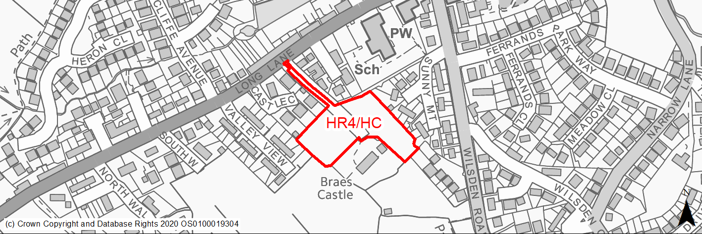
Site location
Local Service Centre - Harden
Ward
Bingley Rural Ward
Site description
Braes Castle is a substantial, detached residential property located in extensive grounds that contain stands of mature trees and lawned areas which make up the proposed development area of this site.
Proposed Allocation
Housing
SHLAA referencce
HR/012
Indicative no. dwellings
4
Site area (Gross) (ha)
0.8
Ownership
Private
Delivery timescales
Developable (6-10 years)
Type (PDL/Greenfield)
Greenfield
Green Belt
No
Flood Zone
Flood Zone 1
Potential site access
Access to site is via a significant length of single track roadway off Long Lane. The planning permission requires a necessary degree of improvements to be made to ensure highway safety and to prevent the possibility of vehicles standing in Long Lane to allow other to emerge from the access track. Any development at this site would need to comply with the relevant access arrangements.
Public Transport Accessibility
Within 400m of a bus stop but very limited service.
Sustainability Appraisal
There are unlikely to be any significant effects, either positive or negative, on any SA Objective arising as a result of development at this site.
Minor positive effects were predicted for a range of socio-economic themed SA Objectives due to the benefits of new residential development for the local economy as well as the location of the site in relation to transport links, health and education facilities and employment areas. Access to services and amenities is limited however, and residents may find they need to travel way beyond the target distance.
Minor adverse effects were predicted for a range of natural environment themed SA Objectives, primarily as a result of the impacts of new development on a 100% greenfield site containing trees.
Habitats Regulations Assessment
This site falls within 7km of the South Pennine Moors SPA/SAC a HRA must be undertaken to ensure there are no significant effects on these protected sites in terms of recreational pressures. Developments within these zones must comply with Policy SP11; an SPD is being produced to provide further guidance.
Green Belt
N/A – Site not within the Green Belt.
Constraints and Opportunities
• Relevant constraints and opportunities have been considered as part of the planning application process.
Development considerations
• Relevant development considerations have been taken into account as part of the planning application process.
Conclusion/Summary
This site has planning permission for 4 dwellings (16/06664/FUL approved 27.09.16) (19/02861/CLP confirmed discharge of condition 1 relating to timescales for commencement of development).