
Draft Bradford District Local Plan - Preferred Options (Regulation 18) February 2021
Oakworth
Introduction
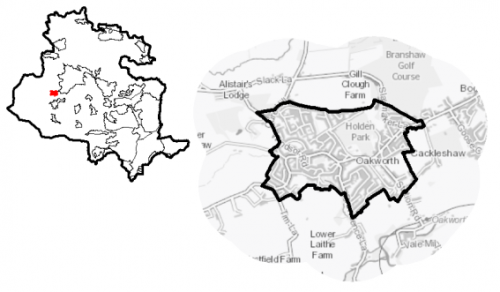
5.23.1 Oakworth is a small village located approximately 3.5km to the south west of Keighley and 16km to the northwest of Bradford City Centre. The settlement is situated between Keighley and Haworth on the B6143. It is one of nine settlements located in the South Pennine Towns and Villages sub-area. Oakworth falls within the Keighley Parliamentary Constituency and within the Worth Valley Ward.
Figure 1: Location Plan
5.23.2 The settlement has a population of 3,547 and a high percentage of this (63.9%) falls within the working age category (16-64). Oakworth has a slightly higher proportion of older persons (18.3%) compared to the West Yorkshire (16.7%) average. The ethnic composition of Oakworth is primarily made up of people who identify themselves as White British – accounting for 97.1%. This is a notably higher proportion than the West Yorkshire average (78.4%), but is similar to other smaller rural settlements in the District.
Planning for Prosperity
5.23.3 The Local Plan settlement hierarchy identifies Oakworth as one of Bradford district's 11 Local Service Centres. This means that it will see a smaller scale of development, comprising both market and affordable housing, as well as the protection of its local centre to help ensure the continued provision of economic activity in the area.
5.23.4 No one in Oakworth is living in the most deprived 20% of areas in England, as outlined in the Indices of Multiple Deprivation (2019).
Economy and Employment
5.23.6 Economic activity rates are notably positive for Oakworth with 78.5% of the resident population economically active compared to the West Yorkshire average (68.5%) and of those a higher number are within full-time employment compared to the sub-regional average. Average household income at £43,700 is also above the West Yorkshire average (£38,499), but is similar to other smaller settlements within the District. The main employment sectors that the residents of Oakworth work in include: retail, health and social work, and manufacturing.
5.23.7 There are limited employment opportunities within the village with most jobs being focussed around the retail or service sector. There are no designated employment areas within the village with most residents having to commute out of the settlement to larger centres to access a wider range of employment.
5.23.8 Business Register and Employment Survey (BRES) data indicates that the three largest industry groups by workforce jobs (all people in employment) are: retail industry, health, and construction.
5.23.9 The local plan does not seek to specifically allocate employment land within this Local Service Centre, but the plan is supportive of appropriately sited and scaled economic growth and diversification within the Pennine Towns and Villages.
Retail
5.23.10 The retail provision in Oakworth is centred around the Co-op foodstore, which also contains a Post-Office counter. Other retail and services on offer include a Pharmacy, hairdressers and beauty salons, as well as takeaways and public houses.
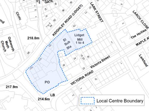
5.23.11 The 2019 Retail and Leisure Study concluded that Oakworth is a stable centre that is well anchored by the Co-op Food store and the GP/pharmacy. A new local centre boundary has been proposed by the study and is set out in Figure 2 below.
Figure 2: Oakworth Local Centre
Transport and Access
5.23.12 Oakworth is connected to the Principal Town of Keighley along the B6143 which provides the main road network into the village. Car ownership in the settlement is relatively high with around 75% of households having at least one car. This is slightly higher than the West Yorkshire average (60%) and reflects the rural nature of the settlement with a limited number of public transport options and a smaller range of retail outlets and facilities, meaning residents have to travel further to access such services.
5.23.13 The main bus services are provided by the Keighley Bus Company (Transdev Blazefield), with the K7 Keighley Jet service providing a connection to Keighley every 20 minutes. Oakworth Station on the Keighley and Worth Valley Railway is located outside the settlement limits to the south of the village. However, this is a heritage line providing for the tourist market rather than being a commuter service. The nearest public railway station is located in Keighley, around 4km away, which offers services to Bradford, Leeds, Skipton and further afield through transfers from these stations.
5.23.14 There are a number of footpaths and Bridleways which penetrate the village and directly connects it to the wider countryside providing residents with opportunities for walking and cycling.
5.23.15 In relation to digital accessibility, the average broadband download speed in Oakworth is around 39 megabytes per second which is below the West Yorkshire average of 44.57. There are no premises where speeds are below the Universal Service Obligation (USO)[1].
Planning for Homes
5.23.16 There are 1,539 dwellings within the settlement area. A large proportion of these properties are owner occupied (80.9%) which is significantly higher than both the West Yorkshire (63.4%) and England (64.1%) averages. Nearly 13% of properties are private rented, with the remainder being made up of socially rented properties. This tenure make-up suggests that there is limited affordable housing available within the settlement.
5.23.17 Oakworth has a varied mix of house types ranging from older terraced properties and cottages located around the historic core and to the west, accounting for 41.1% of properties in the village. More modern detached (18.1%) and semi-detached (33.3%) houses are located to the south and north where the village expanded during the latter half of the twentieth century.
5.23.18 The average house price (all types) in Oakworth is £184,804 which is similar to the West Yorkshire average of £183,194. However, prices for detached properties is notably higher and semi-detached notably lower than the West Yorkshire averages. Figure 3 below presents the average house price by type for properties in Oakworth.
Figure 3: Oakworth – House Prices
|
Average house price (all types of housing) (Land registry Sept-19 to August-20) |
Average house price (detached) (Land registry Sept-19 to August-20) |
Average house price (flats) (Land registry Sept-19 to August-20) |
||
|
£184,804 |
£385,571 |
N/A |
||
|
West Yorkshire average = £183,194 |
West Yorkshire average = £324,872 |
West Yorkshire average = £128,299 |
||
|
Average house price (semi-detached) (Land registry Sept-19 to August-20) |
Average house price (terraced) (Land registry Sept-19 to August-20) |
Households in Council Tax Band A (Valuation Office Agency (VOA) 2020) |
||
|
£161,647 |
£138,818 |
274 |
||
|
West Yorkshire average = £178,439 |
West Yorkshire average = £132,430 |
17.1% (West Yorkshire average = 43.1%) |
||
|
Households in Council Tax Band B (VOA 2020) |
Households in Council Tax Band C (VOA 2020) |
Households in Council Tax Band F-H (VOA 2020) |
||
|
371 |
517 |
95 |
||
|
23.1% (West Yorkshire average = 20.2%) |
32.3% (West Yorkshire average = 17.6%) |
5.9% (West Yorkshire average = 4.3%) |
5.23.19 The delivery of new housing is a key part of the development strategy for Oakworth. This will ensure that the housing needs of local people can be met, both in terms of market and affordable housing. New housing will also allow for the modest growth of the settlement, to attract new residents and to help sustain the provision of services and facilities.
5.23.20 Policy SP8 in the local plan sets a minimum requirement of 75 dwellings to be delivered in Oakworth during the plan period. These will be delivered through a mix of committed sites (those under construction or have planning permission but have not yet commenced), and allocations. Table 1 below set out the housing position for Oakworth, which also includes the application of non-implementation or discount rates for planning permissions and allocations.
Table 1: Oakworth – Summary of Housing Requirement and Supply
|
Housing Target |
75 units |
|
Carried Forward Commitments |
0 |
|
Commitment Discounted by 10% |
0 |
|
Remaining Allocation Requirement |
75 |
|
Identified Allocations |
95 |
|
Allocations Discounted by 10% |
85 |
|
Total Supply Contribution from Allocations |
85 |
5.23.21 There are no existing commitments in Oakworth and therefore sites for the full housing requirement of 75 units must be identified. The evaluated total site supply of housing units from the preferred allocation sites equate to 95 units, which is in turn discounted by 10% for non-implementation or under delivery, leaving a final allocation contribution of 85 units.
5.23.22 The site assessment indicated that there were no suitable in-settlement site options, and therefore two Green Belt sites have been identified as the preferred housing options for Oakworth to meet the housing requirement. In delivering the target for new homes in Oakworth it has been necessary to make some changes to the adopted green belt. Policy SP5 sets out The Councils approach and justification for green belt releases to accommodate new development and lists the sites proposed for allocation which current lie within or partly within the green belt. Further information on these proposed allocations is set out in Table A and identified on the Policies Map and the Site Pro Formas below, together with the local strategies map for each plan area. Development of site allocations should be in accordance with specified development guidelines and approximate site provision figures and all other relevant policies of this Local Plan. The Council will be supportive of additional proposals for new homes on additional small sites, particularly those that provide a redevelopment opportunity to bring forward land which has been previously used. Support will also be provided to developers who wish to redevelop larger sites and/or buildings for new homes not currently identified, subject to all relevant policies in the Local Plan.
Planning for Places and Communities
Green Belt, Natural Landscape and Historic Character
5.23.23 The Green Belt forms a tight boundary around the built-up area of Oakworth providing little room for growth and expansion. The settlement is surrounded by two dominant landscape types: Upland Pasture to the north and Mixed Upland Pasture to the East, West and South. The upland pasture is of strong character and has a prominent, open aspect which would be sensitive to change through inappropriate development. The Mixed Upland Pasture landscape is of strong character, has high historic continuity, visual prominence and feelings of openness. It is a landscape which is already at its capacity and therefore sensitive to any further development.
5.23.24 Oakworth Conservation Area covers a large part of the central historic core of the village stretching as far as the village boundary with Keighley to the East and over to Lane Ends to the West. It incorporates Holden Park to the north and the more rural aspects of the village, including small groups of cottages to the south. There are 34 Grade II Listed Buildings within the village and include Christ Church and the Primary School, as well as a number of residential properties. Holden Park occupies the former grounds of Oakworth House, once owned by the inventor Sir Issac Holden, which was destroyed by fire in the early twentieth century. In terms of other heritage designations, there are no scheduled monuments or known archaeological sites within the village.
Green Infrastructure, Ecology, Open Space and Flood Risk
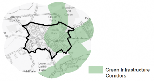
5.23.25 To the south and east of the village are Green Infrastructure (GI) corridors which link together areas of greenspace, woodland and the wider countryside which form a multifunctional network and provide benefits for biodiversity, help to reduce flood risk and are offer important public rights of way (figure 4). These corridors should be protected and enhanced, with new developments identifying opportunities to connect greenspace together and linking into the wider networks.
Figure 4: Green Infrastructure Corridors
5.23.26 Although there are no formally designated Local Wildlife Sites or Local Nature Reserves in Oakworth, there are notable areas of land which are identified as forming part of the Local Wildlife Habitat Network. This network runs from the north along the route of Gill Clough and the Branshaw Plantation down through Holden Park and south where it joins another network which runs along the River Worth. There are also areas of Priority Habitat which coincide with the Wildlife Habitat Network, but are also found to the southwest and northwest of the settlement. These areas of land provide vital habitats to support important wildlife species.
5.23.27 The South Pennine Moors SPA/SAC is situated to the west of the settlement. Half of the village is within the 2.5km zone of this Internationally designated wildlife habitat meaning that certain sites within this area may be utilised by the SPA qualifying species for foraging. The whole settlement is within 7km of the SPA/SAC meaning that new development would be required to contribute to mitigate the potential increased recreational impact of the increase in population.
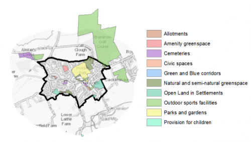
5.23.28 Oakworth benefits from a number of designated open space sites. There are 20 sites of various types which cover a total area of 19.63ha in the village. The most prominent open space site is Holden Park which includes a Bowling Green, Children's Play area and wooded areas. This park is located at the centre of the village and offers a key recreation space. Oakworth Cricket club and Oakworth Cemetery and Crematorium are located just outside the settlement limits to the northwest. There are small deficits of Allotments and Amenity Greenspace and consideration should be given as to the possibilities of increasing provision of these types where possible.
Figure 5: Oakworth – Open Space Overview
5.23.29 A tributary of the River Worth runs along the southern edge of the village, much of which is culverted, but nevertheless results in areas of land identified as being within Flood Risk Zones 2 and 3. There are also significant areas of the village, particularly to the east which are identified as having an increased risk of surface water flooding.
Community Infrastructure – Education, Health and Utilities
5.23.30 Oakworth has a small number of community facilities available to meet the day to day needs of local people. These mainly consist of Oakworth Village Hall, local shops, takeaways, parks and play areas, places of worship and public houses. Residents would need to travel to neighbouring Keighley or further afield to Bradford to access a wider choice of shops and facilities such as libraries, sport and leisure centres and financial services.
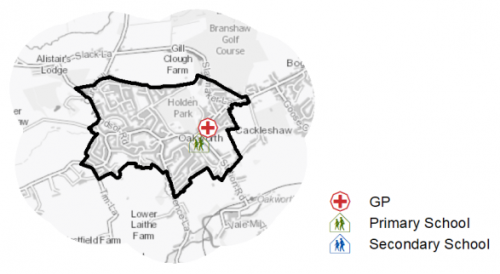
5.23.31 Oakworth Primary School is located off Chapel Lane and is part of the Bronte Academy Trust. The school is a two form entry academy offering annual admissions for 60 pupils. Secondary provision has to be accessed in nearby Keighley, with the Beckfoot Oakbank Academy located approximately 2km away.
5.23.32 Oakworth Medical Practice provides primary care to the residents of the village, and is part of the Modality Partnership which includes a number of other GP practices in the wider Airedale and Wharfedale area. The nearest secondary (acute) care provision is located at Airedale General Hospital, around 6km to the north. There is also a pharmacy and a dental clinic within the village. Figure 6 shows the location of local facilities.
Figure 6: Oakworth – Schools and GP Practices
5.23.33 When planning for the long-term development of Oakworth, it is vital that new development is supported by the appropriate infrastructure. The capacity, quality and accessibility of services and facilities are all key components in ensuring people can enjoy living, working and visiting the area. The Council will continue work with key infrastructure providers and others including the Local Education Authority, Clinical Commissioning Group and utilities providers to determine the impacts of future growth and development on local infrastructure capacity and provision. Further infrastructure details will be published through the Local Infrastructure Plan and as part of the Regulation 19 stage of the local plan.
|
Local Area Strategy and Plan – Oakworth The key elements of the local area strategy for Oakworth include: 
|
(53) Consultation Question 132
Oakworth Local Area Strategy
The Local Plan sets out a local area strategy for Oakworth.
Q. Please provide any comments you may have on the area strategy?
If you have an alternative to the approach undertaken, please provide further details and evidence in support.
Preferred Site Allocations and Site Pro Formas
5.23.34 The preferred housing site allocations are detailed below in Table A. This table is subsequently followed by site pro formas providing a summary of key site information and characteristics.
Table A: Housing - Preferred Allocations
|
Site Ref |
Site Name |
Dwellings |
|
OA1/H |
Pasture Avenue |
34 |
|
OA2/H |
Keighley Road / Sykes Lane (1) |
61 |
|
Total |
95 |
(32) Consultation Question 133
Oakworth Site Allocations and Site Pro Formas
The Local Plan sets out the preferred site allocations for Oakworth. If you wish to make representations on the sites proposed, please provide feedback under this question.
If you wish to propose an additional or alternative site(s) to the preferred allocations listed, please also provide a plan with a red line and any further details in support.
[1] Universal Service Obligation (USO) - download speeds at or above 10Mbit/s and upload speeds at or above 1Mbit/s including non-matched records and zero predicted speeds
(121) OA1/H - Pasture Avenue
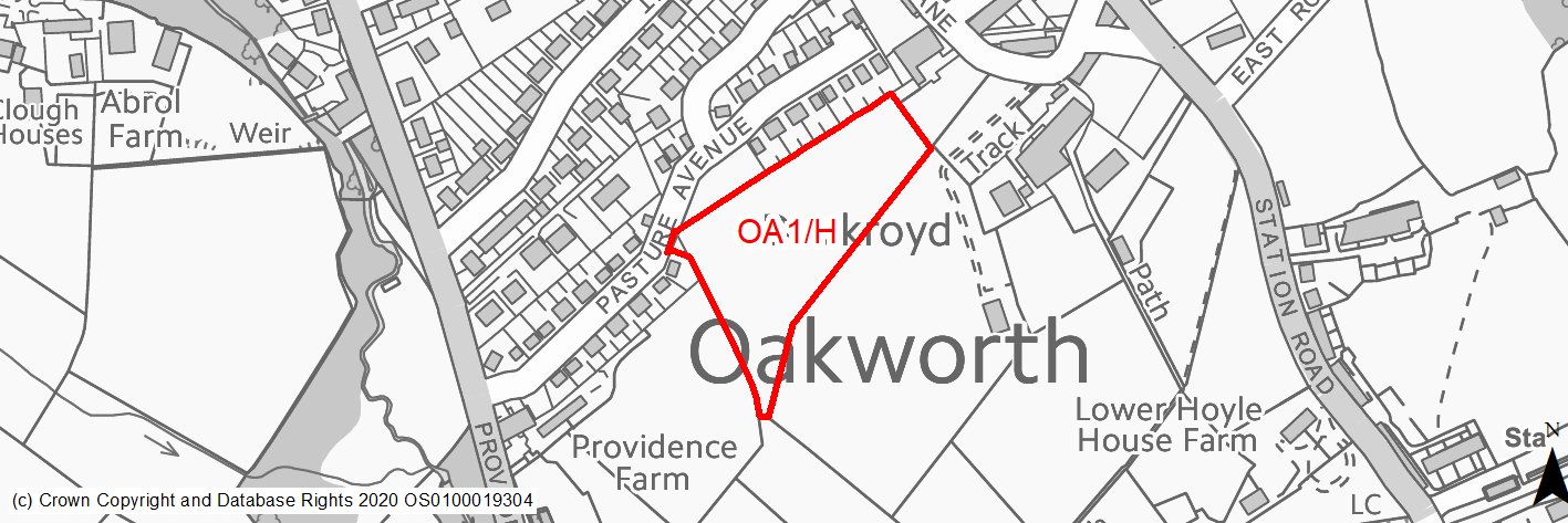
Site location
Local Service Centre - Oakworth
Ward
Worth Valley Ward
Site description
This site consists of an unused agricultural field bounded by trees along its southern edge. It is slightly sloping and accessed from existing development off Pasture Avenue.
Proposed Allocation
Housing
SHLAA referencce
OA/002
Indicative no. dwellings
34
Site area (Gross) (ha)
1.06
Ownership
Private
Delivery timescales
Developable (11-15 years)
Type (PDL/Greenfield)
Greenfield
Green Belt
Yes
Flood Zone
Flood Zone 1
Potential site access
Farmgate access into the field. This would need to be developed into a made road access. Visibility splays should be possible.
Public Transport Accessibility
Site within 400m of a bus stop but only an hourly service.
Sustainability Appraisal
The site could deliver a major positive effect for residents on the health SA Objective as a result of being within the target distances for all necessary health facilities.
Minor positive effects were predicted for nearly all other socio-economic themed SA Objectives due to the benefits of new residential development for the local economy as well as the location of the site in relation to transport links, local services and amenities, education facilities and employment areas.
No major adverse effects have been predicted for the site, but minor adverse effects were predicted for a range of natural environment themed SA Objectives, primarily as a result of the impacts of new development on a 100% greenfield and Green Belt site containing trees. The site adjoins Oakworth Conservation Area, the setting of which could be adversely altered as a result of development on this open greenfield site.
Habitats Regulations Assessment
This site falls within 7km of the South Pennine Moors SPA/SAC. A HRA must be undertaken to ensure there are no significant effects on these protected sites. Developments within these zones must comply with Policy SP11; a SPD is being produced to provide further guidance.
Green Belt
Based on planning judgement the site has a moderate potential impact on the Green Belt.
• The site is in a moderate performing Green Belt parcel.
• The site makes a major contribution to the purposes of including land in the Green Belt.
• The site has a moderate potential for sprawl and would have a major impact on the openness of the Green Belt.
• The site would create a new Green Belt boundary of similar strength to that of the existing one.
Constraints and Opportunities
• The site is currently designated as Green Belt, and the site specific Green Belt assessment indicates that it has a moderate potential impact.
• Some moderate Landscape impacts which may require some mitigation and the retention of the existing trees along the southern and western site boundaries.
• Possible opportunity to provide some additional on-site open space.
• Existing farmgate access which would need improvements.
• The site is located within the 7km buffer of the SPA/SAC.
Development considerations
• Provision of compensatory improvements to the surrounding Green Belt which may include provision of better connections to the existing public rights of way network and enhancement of nearby biodiversity assets.
• The site should incorporate soft landscaping and on-site open space to mitigate against the landscape impact and loss of a greenfield site.
• Direct access off Pasture Avenue but would need to be improved to adoptable standards.
Conclusion/Summary
This is a sustainable site located adjacent to the settlement boundary and within a reasonable proximity of a number of services and facilities. The site would deliver an estimated 33 dwellings and would provide a small extension to the urban area linked to the recent development at Pasture Avenue.
(136) OA2/H - Keighley Road, Sykes Lane
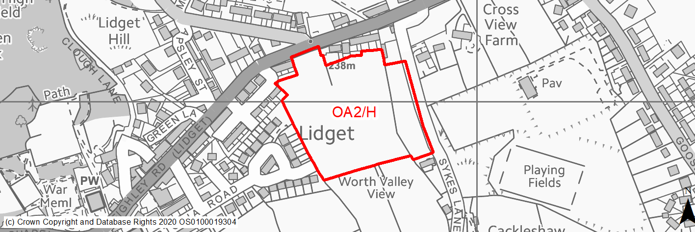
Site location
Local Service Centre - Oakworth
Ward
Worth Valley Ward
Site description
This site is a greenfield site consisting of large agricultural fields which slope downhill from north to south. The site is located on the eastern edge of Oakworth adjacent to existing residential development on Privet Drive/Maple Avenue.
Proposed Allocation
Housing
SHLAA referencce
OA/007A
Indicative no. dwellings
61
Site area (Gross) (ha)
2.31
Ownership
Private
Delivery timescales
Developable (6-15 years)
Type (PDL/Greenfield)
Greenfield
Green Belt
Yes
Flood Zone
Flood Zone 1
Potential site access
There is no existing access point off the main road network into the site. The main access option would be off Keighley Road however there is a significant change in levels from the road into the site at this point. Engineering works would be required to rectify the level change. Furthermore additional highways works would be required to reconfigure the junction with Slaymaker Lane opposite the site. A secondary (emergency access) could be provided off Maple Avenue - although the capacity of this road is limited due to its width.
Public Transport Accessibility
Site within 400m of a bus stop but only an hourly service.
Sustainability Appraisal
The site could deliver a major positive effect for residents on the health SA Objective as a result of being within the target distances for all necessary health facilities.
Minor positive effects were predicted for nearly all other socio-economic themed SA Objectives due to the benefits of new residential development for the local economy as well as the location of the site in relation to transport links, local services and amenities, and education facilities.
No major adverse effects have been predicted for the site, but minor adverse effects were predicted for a range of natural environment themed SA Objectives, primarily as a result of the impacts of new development on a 100% greenfield and Green Belt site. The site adjoins Oakworth Conservation Area, the setting of which could be adversely affected as a result of development on this open greenfield site.
Habitats Regulations Assessment
This site falls within 7km of the South Pennine Moors SPA/SAC. A HRA must be undertaken to ensure there are no significant effects on these protected sites. Developments within these zones must comply with Policy SP11; a SPD is being produced to provide further guidance.
Green Belt
Based on planning judgement the site has a major potential impact on the Green Belt.
• The site is in a major performing Green Belt parcel.
• The site makes a major contribution to the purposes of including land in the Green Belt.
• The site has a moderate potential for sprawl and would have a major impact on the openness of the Green Belt.
• The site has the potential to create a stronger Green Belt boundary than that of the existing one.
Constraints and Opportunities
• The site is currently designated as Green Belt, and the site specific Green Belt assessment indicates that it has a major potential impact.
• Potential significant landscape impact which would require mitigation.
• No existing access into the site from the main road network, but there is an option off Keighley Road.
• The site is located within the 7km buffer of the SPA/SAC.
Development considerations
• Provision of compensatory improvements to the surrounding Green Belt which may include provision of better connections to the existing public rights of way network and enhancement of nearby biodiversity assets.
• Provision of suitable boundary treatments to the south and east to create a new, strong Green Belt boundary.
• Provision of on-site open space will be required.
• A sensitively designed scheme incorporating relevant green infrastructure to minimise landscape impact and loss of a greenfield site.
• A new access point will need to be created off Keighley Road and consideration of pedestrian and cycle routes to the west of the site to ensure sustaiable access to local services and facilities.
Conclusion/Summary
This is a sustainable site located adjacent to the settlement boundary and with good access to a number of services and facilities. The site would provide an estimated 61 dwellings as part of a moderate-sized urban extension helping to sustain local services and facilities.