
Draft Bradford District Local Plan - Preferred Options (Regulation 18) February 2021
Bradford South West
Introduction
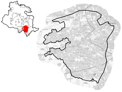
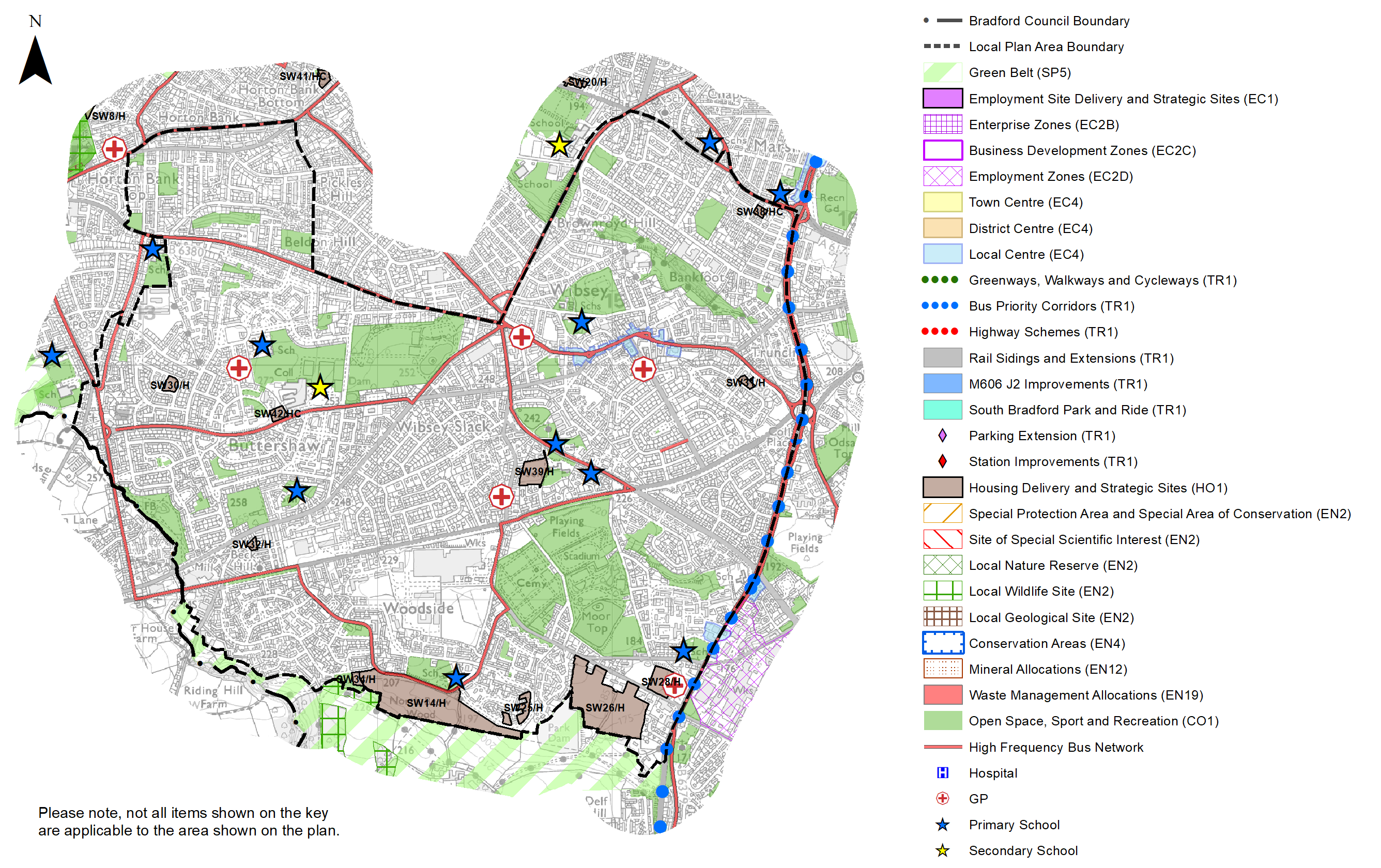
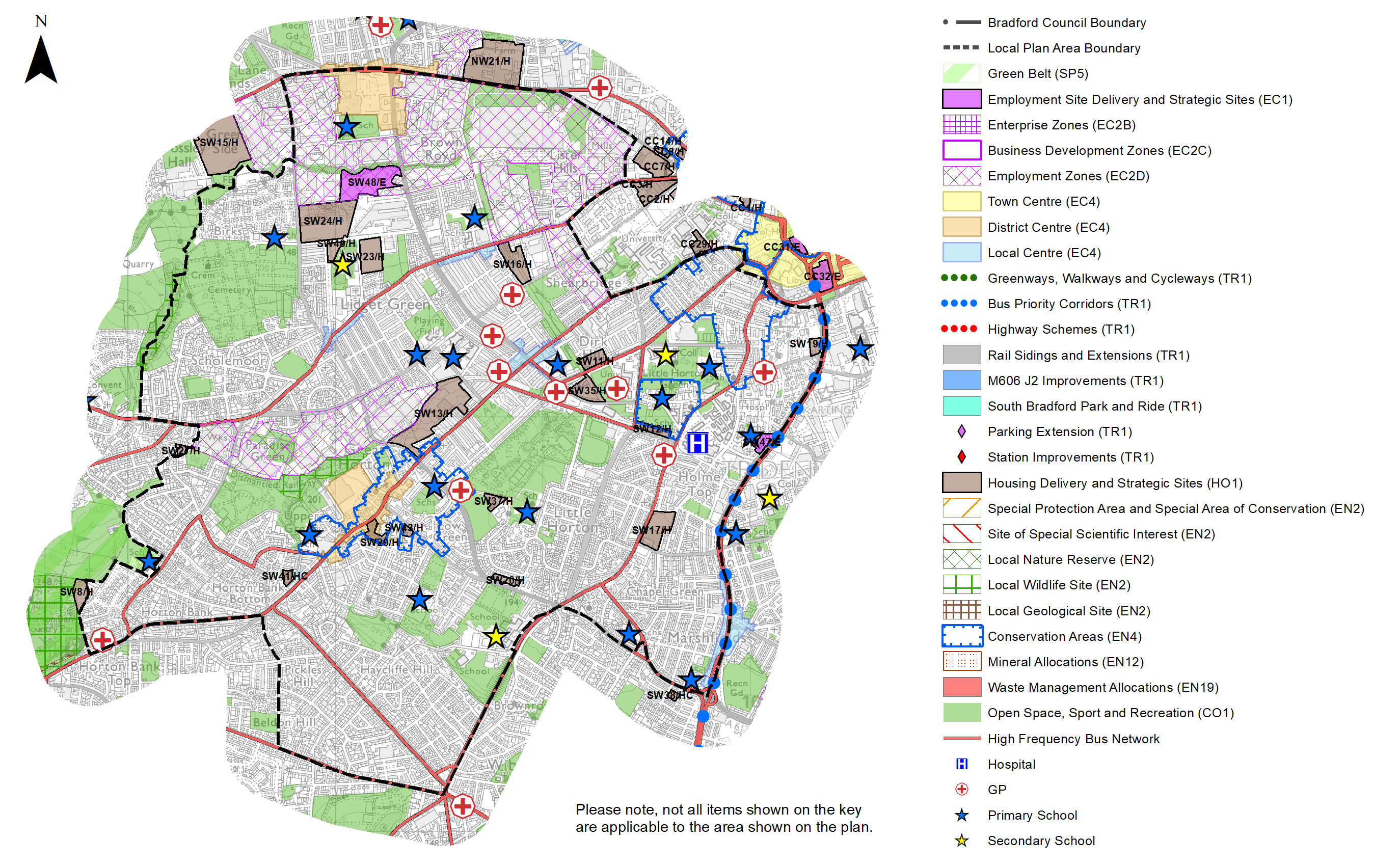
5.4.1 The Local Plan settlement hierarchy identifies Bradford South West as one of four quadrant areas within the wider Regional City of Bradford. It is broadly defined by Thornton Road to the north, A641 Manchester Road / Huddersfield Road to the East and the green belt boundary to the south and west. It covers an area of 1,685 hectares and is primarily residential in character with strong commuter and access connections to Bradford City Centre and further afield to Halifax, Huddersfield, Leeds, Manchester and London.
5.4.2 Bradford South West includes the wards of Great Horton, Royds and large parts of Wibsey, Little Horton, Clayton and Fairweather Green as well as parts of Queensbury and City Ward.
Figure 1: Location Plan
5.4.3 The area is a densely developed and populated urban environment which has a has a total resident population of 95,699 and contains the highest proportion of the population compared to the other Regional City sub-areas and settlements within the District. Further characteristics of Bradford South West show:
- It has a slightly higher percentage of residents (26.1%) who are aged 0-15 compared to 23.7% and 20.6% of the District and regional averages respectively, whilst it has a below average population of those over 65.
- The population is broadly split into those people who are White British (52.3%) and other ethnicities with people identifying themselves as Pakistani making up the highest minority group (26.1%). 76.3% of the population were however born in England.
- Household composition is broadly similar to the district and regional picture, with the largest number of households (31.8%) consisting of married households. Pensioner households fall below average accounting for 16% compared with the districts average of 18.1%.
- Of the total number of households in Bradford South West, around 20% consist those aged 65 and over.
Planning for Prosperity
5.4.4 The Local Plan settlement hierarchy under Policy SP3 identifies the Regional City as the key focus for housing, employment, shopping, leisure, education, health and cultural activities and facilities. Growth in the South West quadrant will transform the economic, environmental, physical and social conditions of local communities and support the long term regeneration of both the regional city and wider District.
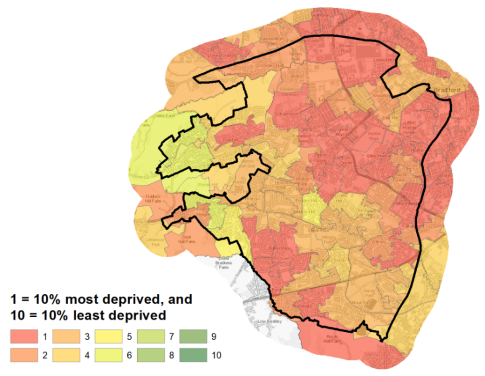
5.4.5 Bradford South West is characterised by pockets of deprivation within all wards, biases include health, income, employment and education deprivation. A total of 56,732 residents (59.3%) are living within the 20% most deprived areas in England by Indices of Multiple Deprivation (IMD) 2019. Little Horton, Great Horton and Clayton and Fairweather Green wards are within the 10% most deprived wards in England for the IMD and are ranked 2nd, 9th and 16th respectively out of 30 wards within the District for deprivation. Figure 2 shows the overall picture of deprivation in Bradford South West.
Figure 2: Index of Multiple Deprivation – Bradford South West
Economy and Employment
5.4.6 The economic activity rate in Bradford South West is slightly lower than the West Yorkshire average of 68.5%. Annual household income is £33,554 which is significantly lower than the West Yorkshire average of £38,499. Unemployment benefit claimants totalled 17.2% in 2019 compared to 14.8% for the District and 12.9% for West Yorkshire.
5.4.7 The three largest industry groups for workforce jobs based in Bradford South West are health, education and retail (Business Register and Employment Survey (BRES)). The three largest employment sectors within the area are retail, accounting for 20%, followed by heath and manufacturing. Bradford College and Bradford University together with St Lukes Hospital are some of the biggest employers in the area.
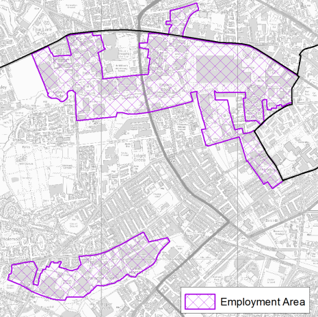
5.4.8 The main employment areas are located to the south of Thornton Rd and north of Legrams Lane and off Beckside Rd (see figure 3 below). There are also pockets of business around Great Horton Rd and south of Halifax Rd
Figure 3: Bradford South West Employment Areas
5.4.9 Policy SP6 sets a District target for the provision of at least 72ha of open market employment land and a significant contribution will come from the Regional City – use classes B2,B8 and E (formerly B1 type uses). The Local Plan employment site allocations are identified in table A and shown on the Policies Map and in the Site pro formas.
Retail
5.4.10 All retail centres have been subject to a review as part of the Retail and Leisure Study (2019). The original study was completed in 2012. The City Centre is the main focus for retail and service provision for the District followed by the Principal Towns, District Centres and Local Centres.
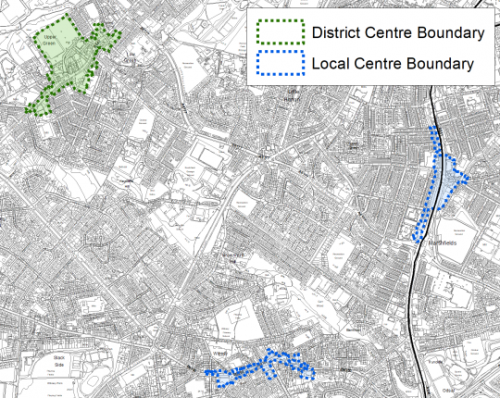
5.4.11 The Local Plan identifies the Great Horton and Girlington District centres as the focus for convenience retail and limited comparison retail and a range of non-retail services such as banks, building societies, restaurants, cafes and local public facilities in the Bradford South West area.
5.4.12 The study considered that Great Horton to be an accessible centre and healthy. However, it also noted that there were some detractors where improvements could be made, including the redevelopment of land recently cleared and improvements to areas of vegetation that was unmaintained.
5.4.13 Girlington District Centre which lies on the border with Bradford North West, with the majority of the area in Bradford South West also provides services outside of daily needs. The study concluded that the centre is the highest ranking District centre in the Bradford District and still performs an important convenience shopping role (Morrisons and Lidl), despite the decrease in recent years, as a result of the opening of other convenience competition in surrounding areas, such as Asda (Cemetery Rd) and Aldi (Allerton Rd). The study also concluded that the vacancy rate was above the national average but that this had changed little since 2012. It concluded that the centre as a whole was performing well despite some neglect and the less attractive environment caused by being located at a busy junction.
5.4.14 The Local Plan also identifies seven designated Local Centres within Bradford South West including:
- Clayton
- Horton Grange
- Lidget Green
- Low Moor
- Marshfields (part on Bradford South East)
- Princeville,
- Wibsey,
5.4.15 The boundaries for these areas are shown on the policies map and in the figures 4a to 4d below. The Local centres cater for general everyday shopping and leisure needs of the local communities.
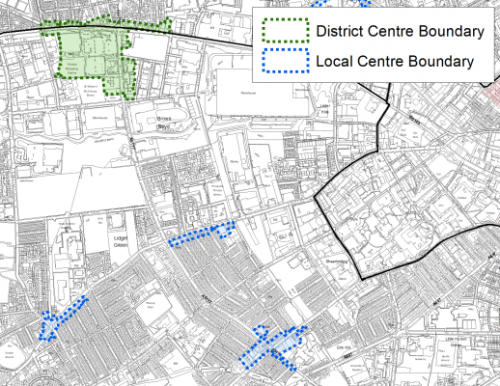
Figure 4a: Great Horton District Centre and Marshfields and Wibsey Local Centres
5.4.16 Marshfields Local centre lies on the border between the Bradford South west sub area and Bradford south east. The Retail and Leisure Study Services commented that this centre had a number of units but lacked diversity. It noted 12 takeaway units but considered it to be in reasonable condition.
5.4.17 Wibsey, whilst having convenience units is supported by numerous hairdressers and beauty salons together with takeaways and pubs/social club and other financial and business services. The study noted that the High Street is heavily trafficked and would benefit from better pedestrian crossing places.
5.4.18 Horton Grange was found to contain a good variety of uses but also had a number of vacant units, it is well served by public transport with some on street parking. Overall the expected uses are similar to national averages. Lidget Green is dominated by takeaways and restaurants which is above the national average and with limited parking which is likely to cause problems when premises are open. Litter and poor building maintenance were hi lighted in the study as being the additional detractors in the area.
5.4.19 The Princeville Local Centre has a good variety of units but with a number of vacancies observed by the Retail and Leisure Study and units with closed shutters which gives the centre a derelict appearance which detracts from the street scene. The boundary of these local centres are shown in figure 4b below.
Figure 4b: Girlington District Centre and Horton, Grange, Lidget Green and Princeville Local Centres
5.4.20 The Low Moor Local centre was noted by the study to have only limited footfall during the day, given that the majority of uses are takeaways and only open in the evenings. Huddersfield Rd is identified as a major detractor but this does capture passing trade. The study considered that maintenance of shop fronts and targeted action to reduce further deterioration of pavements would drastically improve the aesthetics of the centre. The boundary of this local centre is shown in figure 4c below.
Figure 4c: Low Moor Local Centre
5.4.21 Clayton is considered to have a strong offer for local residents and is regarded as an attractive local centre comprised of good quality stone buildings and limited vacancy.
Figure 4d: Clayton Local Centre
5.4.22 In summary the retail offer in the Local Centres offers variety but some key challenges, including the need to monitor vacancy rates and undertake improvements to the environmental quality and appearance of some centres.
Transport and Access
5.4.23 Lying at the southern end of the Bradford District, South West Bradford benefits from a range of excellent travel opportunities within the wider area which provide good links beyond the Bradford District. The A6036 Halifax Road, Thornton and Great Horton Roads and the A641 Huddersfield/Manchester Road are the main roads into and out of the city. The close proximity to the M606 and M62 motorways within the Strategic Highway Network provides a range of travel opportunities for the local communities to travel to Leeds, Manchester and London.
5.4.24 There is good access to Low Moor Railway Station which is a key public 'park and ride' transport hub located within Bradford South East. The station lies on the Calder Valley line between Bradford and Halifax and currently provides an hourly service between the rail stations with connectivity further afield to the Cities of Leeds, Manchester and Liverpool. There are also four direct Grand Central services to London King's Cross each day from this station.
5.4.25 The South West area of Bradford is served by several high-frequency (every 15 to 20 minutes) bus routes with services operated by First Bradford linking to Bradford City Centre, Queensbury and beyond into Halifax and Huddersfield. 36.9% of all households have no car, compared with 29.4% across West Yorkshire. The value of public transport and good walkable local services is therefore of great importance.
5.4.26 The area is not covered by an Air Quality Management Area (AQMA) however the north eastern corner from Southfield Road and Horton Grange Road lies within the proposed Clean Air Zone (CAZ). Land within the vicinity of the A641 Manchester Road, particularly the Mayo Avenue junction towards the city, has been identified as an air quality area of concern.
5.4.27 Ofcom digital connectivity data indicates that, average broadband download speeds in Bradford South West is just over 50 megabytes per second – above the West Yorkshire average, whilst there are 145 premises where speeds are below the Universal Service Obligation (USO)[1].
5.4.28 Strategic transport infrastructure projects to be delivered within the plan period and protected routes are set out on the Policies Map with the local plan. Key initiatives within Bradford South West are detailed in Table 1 below.
Table 1: Bradford South West Transport Projects
|
Policies Map Ref. |
Project Name |
Local Area |
|
TR.C.2 |
Manchester Road TCF |
Great and Little Horton and Royds and Wibsey |
Planning for Homes
5.4.29 Bradford South West has 35,539 dwellings, of which 60.3% are owner occupied, the remainder are rented from landlords, 22.9% privately rented. The largest proportion (40%) of the area's housing stock consists of terraced housing, above the District, sub-regional and regional averages, whist the number of detached dwellings as well as flats are lower. Over a third of the stock was built between 1945 and 1999, with 29.9% being developed between 1900 and 1939 and 23.8% being constructed pre 1900. Figure 5 below provides further information.
Figure 5: Bradford South West – Dwelling Type Breakdown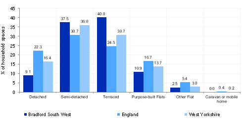
5.4.30 Average house prices across all house types is lower than the West Yorkshire average with £110,535 being the average house price in the area which is over £70,000 less than the regional average of £183,194. The total affordability ratio between house prices and annual earnings which is usually used as a proxy for number of years' worth of earnings required for a house deposit is 2.49 years compared to a West Yorkshire average of 2.96, meaning that the area is theoretically more accessible for first time buyers.
5.4.31 Delivering new housing is a key part of the overall development strategy for the District. The Local Plan seeks to support the creation of sustainable communities in Bradford South West through the regeneration of existing urban areas, particularly supporting the economic, environmental, physical and social transformation of key areas including; Buttershaw and Woodside; re-cycling of brownfield land and; the expansion of the urban area in sustainable locations. It will ensure that the housing needs and aspirations of local people can be met, together with those of future residents, including market and affordable housing. In addition, it will support the economic and regeneration aspirations for the wider area, as well as reflecting its role as the Regional City.
5.4.32 Policy SP8 sets out a requirement of 3,175 dwellings that will be delivered within Bradford South West within the plan period. These will be delivered through a mix of committed sites that are either under construction or have planning permission (but have not yet commenced), as well as new site allocations. New allocations are a mix of sites including existing capacity within the urban area together with some contribution from the Green Belt in sustainable locations. Table 2 below sets out the housing position for the Bradford South West which also includes the application of non-implementation or discount rates for planning permissions and allocations.
Table 2: Bradford South West- Summary of Housing Requirement and Supply
|
Housing Target |
3,175 units |
|
Carried Forward Commitments |
1,101 |
|
Commitment Discounted by 10% |
991 |
|
Remaining Allocation Requirement |
2,184 |
|
Identified Allocations |
2,483 |
|
Allocations Discounted by 10% |
2,235 |
|
Total Supply Contribution from Allocations |
2,235 |
5.4.33 Once the commitments are discounted and removed from the supply this leaves a residual allocation requirement of 2,184 units. The evaluated total supply of housing units from preferred allocation sites equates to 2,483 which in turn is discounted by 10% for non-implementation leaving a final allocation contribution of 2,235 across all sites to meet the remaining requirement. The Council will be supportive of additional proposals for new homes on additional small sites, particularly those that provide a redevelopment opportunity to bring forward land which has been previously used. Support will also be provided to developers who wish to redevelop larger sites and/or buildings for new homes not currently identified, subject to all relevant policies in the Local Plan.
5.4.34 Bradford South West's allocation mix of 43 sites includes, 16 sites which are brownfield and 4 which are mixed brownfield and greenfield, comprising cleared land and buildings suitable for residential re use. The remainder are greenfield sites; 16 are within the urban area, whilst 7 fall within the current Green Belt. The new Local Plan preferred site allocations for residential allocations to meet the Bradford South West housing requirement are set out in Table B and identified on the Policies Map and the Site proformas. In delivering the target for new homes in Bradford South West it has been necessary to make some changes to the adopted green belt. Policy SP5 sets out The Councils approach and justification for green belt releases to accommodate new development and lists the sites proposed for allocation which current lie within or partly within the green belt.
Planning for Places and Communities
Green Belt, Natural Landscape and Historic Character
5.4.35 Bradford South West is characterised by urban landscape divided by established parks and less formal urban greenspaces out to rural landscape which frames the area on the western and south western boundaries. This land lies within the Bradford Green Belt and the Bradford South Landscape Character Area. The prevailing landscape in this area is characterised by a mixture of wooded valley, parkland and enclosed pasture. The landscape as a whole has been assessed as being in moderate to weak character, with low historic continuity and has significant 20th century developments.
5.4.36 The north eastern section of the settlement adjoins the city centre and the streets here are a testament to the Victorian architectural styles seen in the city. The area has four Conservation Areas including - Little Horton, Little Horton Green, Great Horton and Clayton and 1,212 Grade II and 10 Grade II* Listed Buildings. The largest concentration of listed buildings is within the Conservation Areas listed above and within Wibsey village.
Green Infrastructure, Ecology, Open Space and Flood Risk
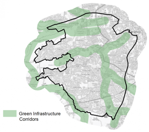
5.4.37 The area has a range of corridors and spaces that contribute towards its Green and Blue Infrastructure networks. These corridors and open areas contribute towards the areas Green and Blue Infrastructure networks that form part of the District's Green Infrastructure network and should be protected and enhanced. These areas are multi-functional in nature and help to deliver benefits for biodiversity, reduce flood risk, provide public rights of way, and areas of open space. New developments should identify the opportunities to connect into these networks by enhancing natural features that exist on-site and improving the links between sites. Key blue corridors include Pinch Beck, Bull Greave Beck and Clayton Beck. Key green corridors include, Judy Woods, Horton Country Park and Horton Park. These are identified below in Figure 6.
Figure 6: Green Infrastructure Corridors
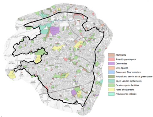
5.4.38 There are number of biodiversity designations within or close proximity to Bradford South West settlement boundary, these include Local Wildlife Sites (LWS) at Horton Country Park, Judy Woods, Railway Terrace and Raw Nook/Toad Holes Beck, Oakenshaw. Additional ecological assets include the natural assets of North Brown and Woods ancient woodlands to the south east of the area such as Odsal Wood and Gannerthorpe Wood.
5.4.39 There are 212 sites identified as open space within Bradford South West covering an area of around 299.56ha. The key sites include Harold Park, Horton Park, Horton Bank Country Park, Bracken Hill Park, Wibsey Park, Scholemoor Cemetery, North Bierley Cemetery, Clayton Golf Course and Horsfall Stadium. There is a good range and spread of provision within the area, however the amount of allotment space, civic space and Green and Blue Corridor space is less available. Figure 7 below provides an illustrative overview of the area's open spaces.
Figure 7: Bradford South West - Open Space Overview
5.4.40 Land to the south of Thornton Road following the route of the Bradford Beck and Middle Brook is identified as being in Flood Zone 3b and to a larger scale Flood Zone 2. There are smaller areas of flood risk identified at Shearbridge and the area around the University of Bradford around West Brook.
5.4.41 Some development proposals in this part of the District are also constrained by the proximity to the middle and outer zones of a designated major hazard site as a result of the nearby Nufarm company located in Wyke. Any proposed developments within these zones will be subject to further consultation with the Health and Safety Executive.
Community Infrastructure – Education, Health and Utilities
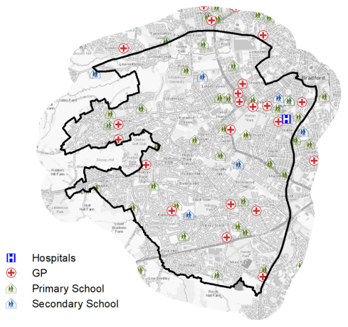
5.4.42 Bradford South West has a wide range of community facilities to meet the day to day needs of its local residents. These facilities range from schools, hospitals, GP surgeries through to post offices, places of worship, community halls/centres, playgrounds, a library and various sporting facilities.
5.4.43 The area is served by 28 primary schools and 5 secondary schools (Dixons Kings Academy, Dixons Macmillan Academy, Dixons Trinity Academy, Co-Op Academy Grange and Buttershaw Business and Enterprise College Academy. Pupils attainment levels at Key Stage 4 (GCSE) is below the West Yorkshire and national (England) average scores – 321.9 compared to 353.5 and 366.3 respectively.
5.4.44 Bradford South West has a number of NHS registered healthcare facilities within the area. There are 16 GP surgeries/health centres, secondary, non-emergency healthcare is provided at St Luke's Hospital in Little Horton, around 1km to the south west of Bradford City Centre. Westwood Park Diagnostic and Treatment Centre and Community Hospital is located at Clayton Heights, with emergency services provide at the Bradford Royal Infirmary (BRI) in Bradford North West. Figure 8 shows the location of local schools and medical facilities.
5.4.45 Average life expectancy at birth for Bradford South West residents is similar to the West Yorkshire and England average, with healthy life expectancy of 60 for both men and women.
Figure 8: Schools & Medical Facilities in Bradford South West
5.4.46 When planning for the long-term development of Bradford South West, it is vital that new development is supported by the appropriate infrastructure. The capacity, quality and accessibility of services and facilities are all key components in ensuring people can enjoy living, working and visiting the area. The council will continue work with key infrastructure providers and others including the Local Education Authority, Clinical Commissioning Group and utilities providers to determine the impacts of future growth and development on local infrastructure capacity and provision. Further infrastructure details will be published through the Local Infrastructure Plan and as part of the Regulation 19 stage of the local plan.
Local Area Strategies and Plans
Bradford South West Local Areas
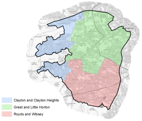
5.4.47 The Bradford South West sub-area has been broken down into 3 defined local areas with supporting spatial strategies; these are referred to as: Royds and Wibsey; Little and Great Horton; and Clayton and Clayton Heights. These local areas are set out in Figure 9 below. Each spatial strategy provides an overview of the local area and sets out the preferred allocations for housing and employment sites.
Figure 9: Bradford South West Local Plan Areas
|
Local Area Strategy and Plan - Royds and Wibsey |
|
The key elements of the local area strategy for Royds and Wibsey include:
|
|
Local Area Strategy and Plan - Great and Little Horton |
|
The key elements of the local area strategy for Great and Little Horton include:
|
|
Local Area Strategy and Plan - Clayton and Clayton Heights |
|
The key elements of the local area strategy for Clayton and Clayton Heights include:
|

(11) Consultation Question 85
Local Area Strategy and Plan - Royds and Wibsey
Q.x Please provide any comments you may have on the area strategy?
If you have an alternative to the approaches undertaken, please provide further details and evidence in support.
(3) Consultation Question 86
Local Area Strategy and Plan - Great and Little Horton
Q.x Please provide any comments you may have on the area strategy?
If you have an alternative to the approaches undertaken, please provide further details and evidence in support.
(19) Consultation Question 87
Local Area Strategy and Plan - Clayton and Clayton Heights
Q.x Please provide any comments you may have on the area strategy?
If you have an alternative to the approaches undertaken, please provide further details and evidence in support.
Preferred Site Allocations and Site Pro-formas
5.4.48 The preferred site allocations for Bradford South West for employment are detailed below in Table A and sites for housing in accordance with Policy HO1 are detailed below in Table B. These tables are followed by site pro formas for each preferred site allocation providing a summary of key site information and characteristics.
Table A: Bradford South West Employment Sites - Preferred Allocations
|
Site Ref |
Site Name |
Site type |
Size (HA) |
Local Area |
|
SW47/E |
Between Clayton Lane and Lister Arms |
Brownfield |
0.52 |
Great and Little Horton |
|
SW48/E |
Ingleby Road |
90% Greenfield 10% Brownfield |
3.25 |
Great and Little Horton |
Table B: Bradford South West Housing Sites - Preferred Allocations
|
Site Ref |
Site Name |
Dwellings |
Local Area |
|
SW1/H |
Back Fold Clayton |
30 |
Clayton and Clayton Heights |
|
SW2/H |
Westminster Avenue |
60 |
Clayton and Clayton Heights |
|
SW3/H |
Ferndale, Clayton |
56 |
Clayton and Clayton Heights |
|
SW4/H |
Brook Lane, Clayton |
35 |
Clayton and Clayton Heights |
|
SW5/H |
Langberries, Clayton |
150 |
Clayton and Clayton Heights |
|
SW6/H |
Highgate Grove, Clayton Heights |
50 |
Clayton and Clayton Heights |
|
SW7/H |
Theakston Mead/Thirsk Grove |
34 |
Clayton and Clayton Heights |
|
SW8/H |
Frensham Drive |
26 |
Great and Little Horton |
|
SW9/H |
South of Highgate Road |
14 |
Clayton and Clayton Heights |
|
SW10/H |
Stocks Lane, Old Dolphin, Clayton Heights |
26 |
Clayton and Clayton Heights |
|
SW11/H |
Dirkhill Road |
50 |
Great and Little Horton |
|
SW12/H |
Horton Park Avenue |
24 |
Great and Little Horton |
|
SW13/H |
Cannon Mills, Cannon Mill Lane/Union Road, Great Horton |
281 |
Great and Little Horton |
|
SW14/H |
Fenwick Drive, Woodside |
200 |
Royds and Wibsey |
|
SW15/H |
Thornton Road/Munby Street |
175 |
Clayton and Clayton Heights |
|
SW16/H |
Cottam Avenue |
57 |
Great and Little Horton |
|
SW17/H |
Briggella Mills, Little Horton Lane |
200 |
Great and Little Horton |
|
SW18/H |
Fall Top Farm, Brook Lane, Clayton |
120 |
Clayton and Clayton Heights |
|
SW19/H |
Junction with Park Rd/Manchester Rd, Little Horton |
22 |
Great and Little Horton |
|
SW20/H |
Quaker Lane, Southfield Lane |
18 |
Great and Little Horton |
|
SW21/H |
Thornton Rd, Leaventhorpe |
51 |
Clayton and Clayton Heights |
|
SW22/H |
Baldwin Lane, Clayton |
57 |
Clayton and Clayton Heights |
|
SW23/H |
Northside Road, Girlington |
60 |
Great and Little Horton |
|
SW24/H |
Northside Road, Girlington |
151 |
Great and Little Horton |
|
SW25/H |
Lingdale Road, Woodside |
19 |
Royds and Wibsey |
|
SW26/H |
Abb Scott Lane, Low Moor |
60 |
Royds and Wibsey |
|
SW27/H |
Paradise Fold, Great Horton |
7 |
Clayton and Clayton Heights |
|
SW28/H |
Abb Scott Lane, Low Moor |
30 |
Royds and Wibsey |
|
SW29/H |
Harris Court Mill, Great Horton Rd |
39 |
Great and Little Horton |
|
SW30/H |
Brafferton Arbor, Buttershaw |
14 |
Royds and Wibsey |
|
SW31/H |
Former Odsal clinic, 55 Odsal Rd |
5 |
Royds and Wibsey |
|
SW32/H |
Church Street, Buttershaw |
10 |
Royds and Wibsey |
|
SW33/H |
Land off Buckingham Crescent, Clayton |
175 |
Clayton and Clayton Heights |
|
SW34/H |
Meadway, Wibsey |
7 |
Royds and Wibsey |
|
SW35/H |
All Saints Road |
50 |
Great and Little Horton |
|
SW36/HC |
Highgate Road, Clayton Heights |
5 |
Clayton and Clayton Heights |
|
SW37/H |
Cousen Road |
11 |
Great and Little Horton |
|
SW38/HC |
Dovesdale Road |
9 |
Royds and Wibsey |
|
SW39/H |
Bowman Road, Wibsey |
44 |
Royds and Wibsey |
|
SW40/H |
Northside Road |
19 |
Great and Little Horton |
|
SW41/HC |
Blamires Street |
9 |
Great and Little Horton |
|
SW42/HC |
Reevy Road, The Crescent, Buttershaw |
14 |
Royds and Wibsey |
|
SW43/H |
Bell House, Southfield Lane |
9 |
Great and Little Horton |
|
Total |
2,483 |
Note: The sites labelled "HC" had outline planning permission at 31st March 2020
(13) Consultation Question 88
Bradford South West Site Allocations and Site Pro Formas
The Local Plan sets out a series of preferred site allocations. If you wish to make representations on any of the sites proposed, please provide site reference and feedback under this question.
If you wish to propose an additional or alternative site(s) to the preferred allocations listed, please also provide a plan with a red line and any further details in support.
[1] Universal Service Obligation (USO) - download speeds at or above 10Mbit/s and upload speeds at or above 1Mbit/s including non-matched records and zero predicted speeds
(2) SW47/E - Between Clayton Lane and Lister Arms, Manchester Road
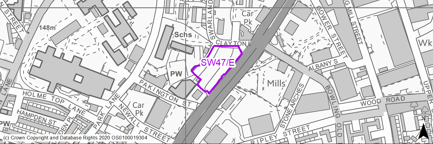
Site location
Regional City - Bradford SW
Ward
City
Site description
Cleared site now covered in coarse grass and shrubs. Currently for sale.
Proposed Allocation
Employment
SHLAA referencce
SW/047 - multiple
Indicative no. dwellings
N/A
Site area (Gross) (ha)
0.52
Ownership
Public
Delivery timescales
2025-30
Type (PDL/Greenfield)
PDL - 100%
Green Belt
No
Flood Zone
Primarily Flood Zone 1 - low risk of flooding - small area of Flood Zone 2 to eastern edge.
Potential site access
Existing access road in place onto Manchester Road.
Public Transport Accessibility
Bus Stop within 400m Frequent service
Sustainability Appraisal
The site has been proposed for employment development, which would be likely to deliver a major boost to the range of local employment opportunities at this location whilst also providing a boost to the local economy. A major positive score has therefore been predicted for the employment and economy themed SA Objectives.
A significant adverse effect has been predicted for the air quality SA Objective as a result of the site being entirely within the CAZ. Development here could potentially make achieving air quality improvement targets within the CAZ more difficult.
Minor positive effects were predicted for other socio-economic themed SA Objectives due to the additional benefits of a new employment site, such as the potential for increasing the local offering of services and amenities and opportunities to learn new skills.
Minor adverse effects were predicted for a range of natural environment themed SA Objectives, largely due to the potential impacts of new development on green infrastructure within this brownfield site. The eastern perimeter overlaps very slightly with land in FZ2, but given the comparative size of the site, it is expected that it would be avoided through a careful layout of development. There is a Grade II Listed Building adjoining the south-western corner of the site, and three more within 100m; development here could adversely alter the settings of these sensitive heritage assets.
Habitats Regulations Assessment
This site is beyond the zones of influence of the South Pennine Moors SPA/SAC and is therefore unlikely to have any significant effects, a HRA is not required.
Green Belt
N/A – Site not within the Green Belt.
Constraints and Opportunities
• Identified as natural and semi-natural greenspace.
• Veteran trees around the boundary of the site.
• Within landfill buffer.
• Potential impact on nearby residential properties and primary school.
Development considerations
• Existing access off Manchester Road.
• High degree of sensitivity to nearby uses required in scheme design including environmental buffers.
• Likely to be suitable more for office and commercial than industrial use.
Conclusion/Summary
Highly visible and well located site which may be suitable for sensitively designed office and commercial uses within major transport corridor.
Use Class
Class B2/B8, E(g)
(2) SW48/E - Ingleby Road
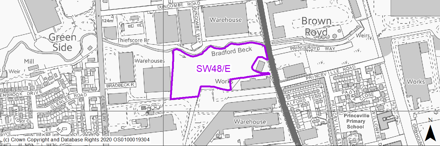
Site location
Regional City - Bradford SW
Ward
Great Horton
Site description
Greened over site. Possibly a former spoil / hardcore tip.
Proposed Allocation
Employment
SHLAA referencce
SW/120
Indicative no. dwellings
N/A
Site area (Gross) (ha)
3.25
Ownership
Private
Delivery timescales
2030-38
Type (PDL/Greenfield)
PDL - 10% Greenfield - 90%
Green Belt
No
Flood Zone
Northern edge with Flood Zone 3b due to proximity to Bradford Beck.
Potential site access
Only viable access point appears to be opposite Wickes access but the two accesses would become a cross roads and therefore may need to be signalised. A major conference/events development was approved recently adjacent to Wickes which will generate significant traffic levels at this location which would need to be taken into account if this site becomes an employment site.
Public Transport Accessibility
Bus Stop within 400m Frequent service
Sustainability Appraisal
The site has been proposed for employment development, which would be likely to deliver a major boost to the range of local employment opportunities at this location whilst also providing a boost to the local economy. A major positive score has therefore been predicted for the employment and economy themed SA Objectives.
A significant adverse effect has been predicted for the air quality SA Objective as a result of the site being adjacent to the CAZ. Development here could potentially make achieving air quality improvement targets within the CAZ more difficult.
Minor positive effects were predicted for other socio-economic themed SA Objectives due to the additional benefits of a new employment site, such as the potential for increasing the local offering of services and amenities and opportunities to learn new skills.
Minor adverse effects were predicted for a range of natural environment themed SA Objectives, primarily as a result of the impacts of new development on a majority greenfield site. Bradford Beck adjoins the site’s northern perimeter; this is likely to be an important biodiversity asset, and development here could pose a risk to the water quality and the local ecological network. The northern perimeter of the site overlaps slightly with land in FZ2 and FZ3a and FZ3b, associated with Bradford Beck, and is at high risk of surface water flooding, although it is expected that these areas would be avoided through a careful layout of development.
Habitats Regulations Assessment
This site is beyond the zones of influence of the South Pennine Moors SPA/SAC and is therefore unlikely to have any significant effects, a HRA is not required.
Green Belt
N/A – Site not within the Green Belt.
Constraints and Opportunities
• Site is situated in an active industrial and retailing area.
• Bradford Beck runs on the northern site boundary with vegetation features - northern edge of site FZ3b due to proximity to the beck.
• Significant GI and vegetation coverage across site and part of GI corridor.
• Site of former Victoria Dye works and also located within landfill buffer.
Development considerations
• Access from A6177 subject to suitable configuration with existing access points and road layout.
• Retention and enhancement of strong environmental buffer along Bradford Beck corridor.
• Integration of GI through scheme.
• Further site investigation and land remediation is required.
Conclusion/Summary
Employment site option within mixed commercial area which will need to balance environmental enhancement and proximity to watercourse with high quality compatible business units.
Use Class
Class B2/B8
(8) SW1/H - Back Fold, Clayton
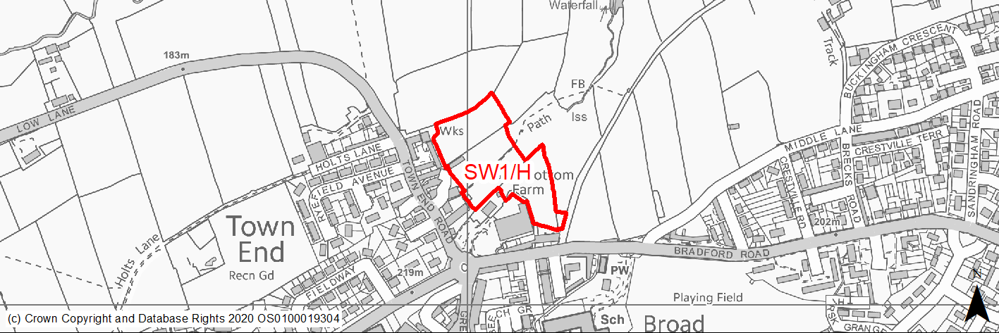
Site location
Regional City - Bradford SW
Ward
Clayton and Fairweather Green
Site description
A greenfield site adjoining Clayton Conservation Area comprising agricultural land and buildings.
Proposed Allocation
Housing
SHLAA referencce
SW/002
Indicative no. dwellings
30
Site area (Gross) (ha)
1.53
Ownership
Private
Delivery timescales
Developable (6-10 years)
Type (PDL/Greenfield)
Greenfield
Green Belt
No
Flood Zone
Flood Zone 1
Potential site access
Access potentially via Deep Lane / Bradford Road. Would depend on third party land.
Public Transport Accessibility
Site within 400m of a High Frequency Bus Network
Sustainability Appraisal
No significant adverse effects predicted for the site. Minor adverse effects predicted for most natural environment themed SA Objectives, primarily as a result of the effects associated with development on greenfield. The loss of open views at the site could adversely affect the local Conservation Area. Site is well located to provide residents with good access to shops, jobs, buses, and cultural spaces, with particularly good access to schools and health facilities.
Habitats Regulations Assessment
This site falls within 7km of the South Pennine Moors SPA/SAC a HRA must be undertaken to ensure there are no significant effects on these protected sites in terms of recreational pressures. Developments within these zones must comply with Policy SP11; an SPD is being produced to provide further guidance.
Green Belt
N/A – Site not within the Green Belt.
Constraints and Opportunities
• The site adjoins Clayton Conservation Area and lies within the 50M buffer zone of a number of listed buildings; development could impact on the open setting and backdrop to these heritage assets.
• Access would have to be secured via adjoining site SW33/H.
• Most of the site lies within the Pity & Clayton Becks Green Infrastructure Corridor identified by Natural England.
• The site is not within the S Pennine Moors SPA / SAC however within Zone C (within 7KM) which requires consideration of potential impacts relating to recreation pressures.
• There is an area through the centre of the site which is subject to surface water flood risk - however the draft SFRA concludes there are no significant risks.
Development considerations
• A low density scheme utilising appropriate and sympathetic scale and materials is proposed which must incorporate a substantial landscaped buffer and where possible preserve views into the conservation area and outwards towards the countryside is required.
• Access would have to be secured via adjoining site SW33/H.
• There is an area through the centre of the site which is subject to surface water flood risk - however the draft SFRA concludes there are no significant risks.
• Flood risk mitigation may be required.
Conclusion/Summary
A sensitive site but offers the opportunity for a quality low density residential development in a sustainable location.
(7) SW2/H - Westminster Avenue
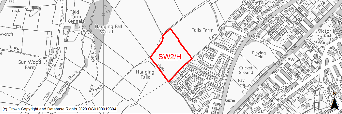
Site location
Regional City - Bradford SW
Ward
Clayton and Fairweather Green
Site description
Agricultural land which adjoins the existing residential area to the south and a new residential development site to the east.
Proposed Allocation
Housing
SHLAA referencce
SW/005B
Indicative no. dwellings
60
Site area (Gross) (ha)
1.72
Ownership
Private
Delivery timescales
Deliverable (0-5 years)
Developable (6-10 years)
Type (PDL/Greenfield)
Greenfield
Green Belt
No
Flood Zone
Flood Zone 1
Potential site access
Access is available from Westminster Drive and / or from adjoining development.
Public Transport Accessibility
Site within 400m of a High Frequency Bus Network
Sustainability Appraisal
No significant adverse effects predicted for the site. Minor adverse effects predicted for most natural environment themed SA Objectives, primarily as a result of the effects associated with development on greenfield. The site is well located to provide residents here with good access to shops, jobs, buses, cultural spaces, and health facilities. Site is outside of the target distance of schools.
Habitats Regulations Assessment
This site falls within 7km of the South Pennine Moors SPA/SAC a HRA must be undertaken to ensure there are no significant effects on these protected sites in terms of recreational pressures. Developments within these zones must comply with Policy SP11; an SPD is being produced to provide further guidance.
Green Belt
N/A – Site not within the Green Belt.
Constraints and Opportunities
• The site lies within the 150M or 250M buffer zones of several former landfill areas.
• Not within the S Pennine Moors SPA / SAC however within Zone C (within 7KM) which requires consideration of potential impacts relating to recreation pressures.
Development considerations
• Surveys required to investigate and mitigate for any issues relating to former landfill activities.
• Access would have to be secured via adjoining development or Westminster Drive.
Conclusion/Summary
A greenfield site within Pool 1 (lowest flood risk and within the urban area) which would form a logical rounding off of the settlement form. A sustainable location for residential development.
(5) SW3/H - Ferndale, Clayton
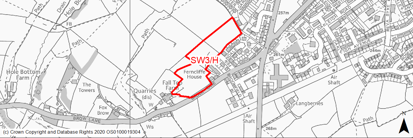
Site location
Regional City - Bradford SW
Ward
Clayton and Fairweather Green
Site description
Greenfield edge of settlement sloping site comprising semi improved grassland.
Proposed Allocation
Housing
SHLAA referencce
SW/006
Indicative no. dwellings
56
Site area (Gross) (ha)
2.13
Ownership
Private
Delivery timescales
Developable (6-10 years)
Type (PDL/Greenfield)
Greenfield
Green Belt
No
Flood Zone
Flood Zone 1
Potential site access
Site can be accessed directly from Brook Lane or via Ferndale but Brook Lane is substandard on its approach to main road at Baldwin Lane which will need mitigating. Options for a new road serving this and sites SW4/H, SW18/H and SW22/H from Baldwin lane to be investigated.
Public Transport Accessibility
Site within 400m of a High Frequency Bus Network
Sustainability Appraisal
No significant adverse effects predicted for this site. Minor adverse effects predicted for most natural environment themed SA Objectives, primarily as a result of the effects associated with development on greenfield. Site is well located to provide residents with good access to shops, jobs, buses, cultural spaces, and health facilities. Site is outside of the target distances for schools.
Habitats Regulations Assessment
This site falls within 7km of the South Pennine Moors SPA/SAC a HRA must be undertaken to ensure there are no significant effects on these protected sites in terms of recreational pressures. Developments within these zones must comply with Policy SP11; an SPD is being produced to provide further guidance.
Green Belt
N/A – Site not within the Green Belt.
Constraints and Opportunities
• Site contains a former quarry / landfill area. Although most of the site is located in Low Risk Area the Coal Authority Mapping indicates the potential presence of a mine entry shaft in the middle of the site.
• The north eastern part of the site contains a former landfill area. The site also lies within 150 and 250 landfill buffer zones of 2 other landfill areas.
• Lies within the Great Northern Trail and Shibden Green Infrastructure Corridor identified by Natural England.
• Site can be accessed directly from Brook Lane or via Ferndale but Brook Lane is substandard on its approach to main road at Baldwin Lane which will need mitigating. Options for a new road serving this and sites SW4/H, SW18/H and SW22/H from Baldwin lane to be investigated.
Development considerations
• Surveys required to investigate and mitigate for any issues relating to former mining and landfill activities.
• Potential access directly from Brook Lane or via Ferndale but Brook Lane is substandard on its approach to main road at Baldwin Lane which will need mitigating. Options for a new road serving this and sites SW4/H, SW18/H and SW22/H from Baldwin lane to be investigated.
Conclusion/Summary
A greenfield site within Pool 1 (lowest flood risk and within the urban area). A sustainable location for residential development.
(6) SW4/H - Brook Lane, Clayton
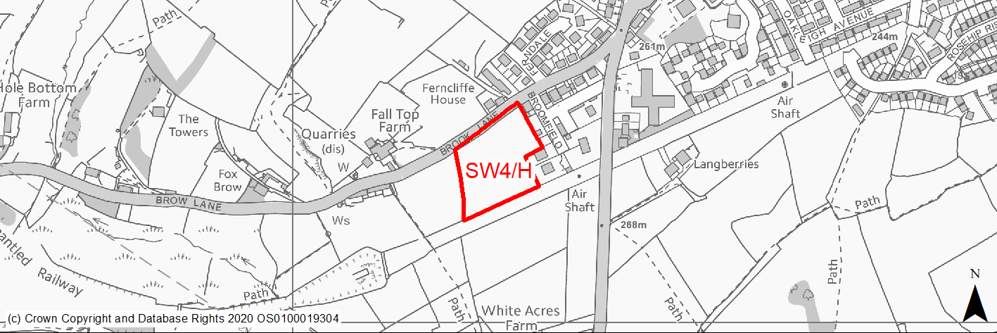
Site location
Regional City - Bradford SW
Ward
Clayton and Fairweather Green
Site description
Level field adjoining residential development comprising semi improved grassland. The site is raised marginally above the road and above neighbouring development to the east.
Proposed Allocation
Housing
SHLAA referencce
SW/007
Indicative no. dwellings
35
Site area (Gross) (ha)
1.12
Ownership
Private
Delivery timescales
Developable (6-10 years)
Type (PDL/Greenfield)
Greenfield
Green Belt
No
Flood Zone
Flood Zone 1
Potential site access
Site can be accessed directly from Brook lane or via Ferndale but Brook Lane is substandard on its approach to main road at Baldwin Lane which will need mitigating. Options for a new road serving this and sites SW3/H, SW18/H and SW22/H from Baldwin lane to be investigated.
Public Transport Accessibility
Site within 400m of a High Frequency Bus Network
Sustainability Appraisal
No significant adverse effects predicted for this site. Minor adverse effects predicted for most natural environment themed SA Objectives, primarily as a result of the effects associated with development on greenfield. Site is well located to provide residents with good access to shops, jobs, buses, cultural spaces, and health facilities. Site is outside of the target distances for schools.
Habitats Regulations Assessment
This site falls within 7km of the South Pennine Moors SPA/SAC a HRA must be undertaken to ensure there are no significant effects on these protected sites in terms of recreational pressures. Developments within these zones must comply with Policy SP11; an SPD is being produced to provide further guidance.
Green Belt
N/A – Site not within the Green Belt.
Constraints and Opportunities
• The site lies within 150 and 250 landfill buffer zones of several landfill areas.
• Lies within the Great Northern Trail and Shibden Green Infrastructure Corridor identified by Natural England.
• Site can be accessed directly from Brook Lane or via Ferndale but Brook Lane is substandard on its approach to main road at Baldwin Lane which will need mitigating. Options for a new road serving this and sites SW3/H, SW18/H and SW22/H from Baldwin lane to be investigated.
Development considerations
• Surveys required to investigate and mitigate for any issues relating to former landfill activities.
• Potential access directly from Brook Lane or via Ferndale but Brook Lane is substandard on its approach to main road at Baldwin Lane which will need mitigating. Options for a new road serving this and sites SW3/H, SW18/H and SW22/H from Baldwin lane to be investigated.
Conclusion/Summary
A greenfield site within Pool 1 (lowest flood risk and within the urban area). A sustainable location for residential development.
(15) SW5/H - Langberries, Clayton Heights
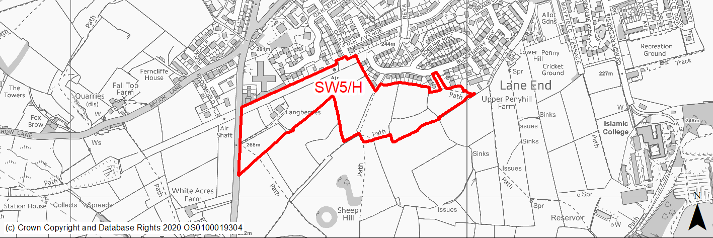
Site location
Regional City - Bradford SW
Ward
Clayton and Fairweather Green
Site description
Sloping and level fields within the green belt adjoining and to the south of the existing built up area of Clayton.
Proposed Allocation
Housing
SHLAA referencce
SW/010A (part of)
Indicative no. dwellings
150
Site area (Gross) (ha)
6.95
Ownership
Private
Delivery timescales
Developable (6-10 years)
Developable (11-18 years)
Type (PDL/Greenfield)
Greenfield
Green Belt
Yes
Flood Zone
Flood Zone 1
Potential site access
There are a number of potential access points - the western section from Baldwin Lane and Oakleigh Avenue, the eastern section from Blackberry Way.
Public Transport Accessibility
Site within 400m of a High Frequency Bus Network
Sustainability Appraisal
See individual Sustainability Appraisal site comment in the accompanying report.
Habitats Regulations Assessment
This site falls within 7km of the South Pennine Moors SPA/SAC a HRA must be undertaken to ensure there are no significant effects on these protected sites in terms of recreational pressures. Developments within these zones must comply with Policy SP11; an SPD is being produced to provide further guidance.
Green Belt
See individual Green Belt site assessment in the accompanying report.
Constraints and Opportunities
• The western part of the site contains a Grade II LB - Langberries Farm, and there are several listed buildings to the NE of the site.
• The site contains several areas of habitat value including hedgerows. Parts of the western end of the site lie within an area identified as Semi Improved Neutral Grassland on the draft Habitat Network layer.
• Most of the site lies within a low risk area for coal mining activity. However, the south eastern edges lies within a high risk area. Coal Authority Mapping indicates that there are no mine entry shafts within the site but there are a couple outside it - one to the south west and one to the north east.
• Not within the S Pennine Moors SPA however within Zone C (within 7KM) which requires consideration of potential impacts relating to recreation pressures.
• There are no landfill areas within the site itself however small parts of the NW and NE edges of the site lie within the 250M buffer zone of former landfill areas.
Development considerations
• Comprehensive masterplanning required which should seek to reduce landscape and green belt impact and incorporate a landscaping and planting scheme which retains where possible key trees and hedgerows and enhances biodiversity.
• Development should retain listed buildings at Langberries farm and include a buffer zone around it to ensure that its setting is protected.
• The existing settlement edge is soften by trees - where possible these should be retained and the new settlement edge should be softened by further planting.
• Surveys required to investigate and mitigate for any issues relating to former coal mining and landfill activities.
• Development should include substantial areas of quality open space.
Conclusion/Summary
This is a greenfield site on the edge of Clayton which could form a sustainable urban extension but will need careful masterplaning to mitigate impacts.
(9) SW6/H - Highgate Grove, Clayton Heights
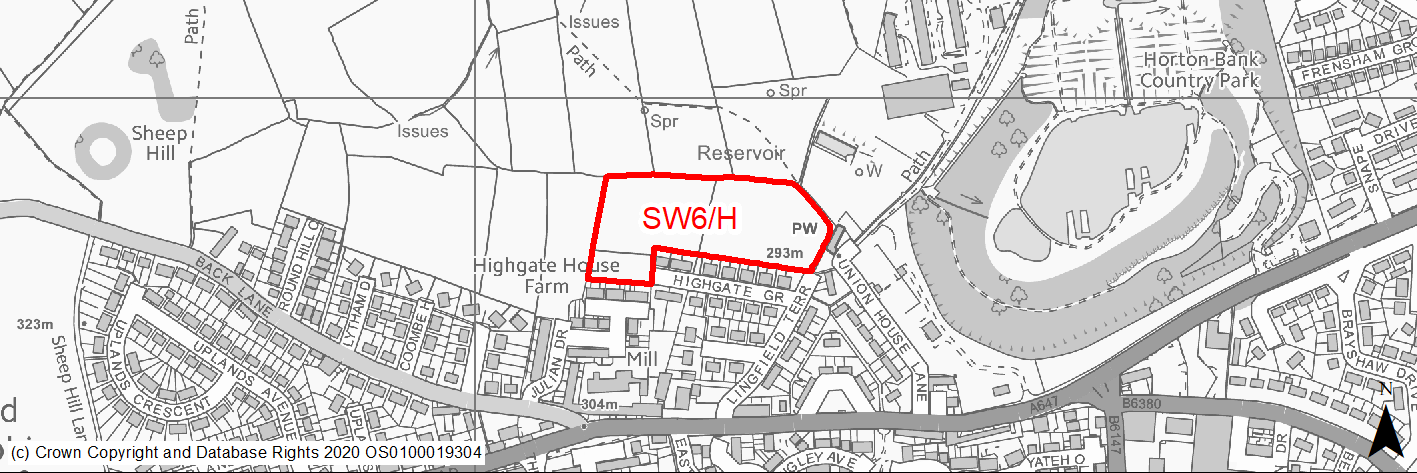
Site location
Regional City - Bradford SW
Ward
Queensbury
Site description
Sloping agricultural fields within the green belt and comprising semi improved grassland on the N edge of the settlement.
Proposed Allocation
Housing
SHLAA referencce
SW/010B (part of)
Indicative no. dwellings
50
Site area (Gross) (ha)
1.76
Ownership
Private
Delivery timescales
Developable (6-10 years)
Type (PDL/Greenfield)
Greenfield
Green Belt
Yes
Flood Zone
Flood Zone 1
Potential site access
Potential access points are from Highgate Grove or Lingfield Terrace if widening feasible.
Public Transport Accessibility
Site within 400m of a High Frequency Bus Network
Sustainability Appraisal
See individual Sustainability Appraisal site comment in the accompanying report.
Habitats Regulations Assessment
This site falls within 7km of the South Pennine Moors SPA/SAC a HRA must be undertaken to ensure there are no significant effects on these protected sites in terms of recreational pressures. Developments within these zones must comply with Policy SP11; an SPD is being produced to provide further guidance.
Green Belt
See individual Green Belt site assessment in the accompanying report.
Constraints and Opportunities
• This site lies in an elevated position adjoining the NE edge of Clayton Heights with the main viability being from the north.
• The site is not within the S Pennine Moors SPA / SAC however within Zone C (within 7KM) which requires consideration of potential impacts relating to recreation pressures.
• There are several listed buildings located at a distance from the site, to the NE and to the S however due to distance and intervening built form these are unlikely to impact significantly upon the setting of the heritage assets and any impact is likely to be able to be mitigated through sensitive design, layout etc.
Development considerations
• Development must include substantial landscaping and planting to mitigate landscape impacts.
• Sensitive design and layout will be required to avoid / mitigate impacts on nearby listed buildings.
Conclusion/Summary
This is a greenfield site on the edge of Clayton Heights which could form a sustainable urban extension provided landscape impacts are mitigated through design, layout and planting.
(2) SW7/H - Theakston Mead/Thirsk Grove
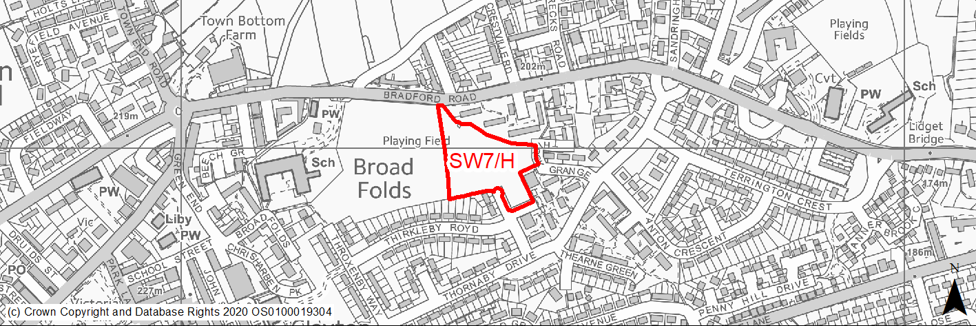
Site location
Regional City - Bradford SW
Ward
Clayton and Fairweather Green
Site description
An area of poor quality and scrubby open land adjoining maintained recreation area to the west. Adjoins residential estate to the east and south.
Proposed Allocation
Housing
SHLAA referencce
SW/013
Indicative no. dwellings
34
Site area (Gross) (ha)
1.08
Ownership
Council/Private
Delivery timescales
Developable (6-10 years)
Type (PDL/Greenfield)
Greenfield
Green Belt
No
Flood Zone
Flood Zone 1
Potential site access
Access is available from Bradford Road.
Public Transport Accessibility
Site within 400m of a High Frequency Bus Network
Sustainability Appraisal
No significant adverse effects predicted for this site. Minor adverse effects predicted for most natural environment themed SA Objectives, primarily as a result of the effects associated with development on greenfield. Site is well located to provide residents with good access to shops, jobs, buses, and cultural spaces, with particularly good access to schools and health facilities.
Habitats Regulations Assessment
This site falls within 7km of the South Pennine Moors SPA/SAC a HRA must be undertaken to ensure there are no significant effects on these protected sites in terms of recreational pressures. Developments within these zones must comply with Policy SP11; an SPD is being produced to provide further guidance.
Green Belt
N/A – Site not within the Green Belt.
Constraints and Opportunities
• Coal Authority mapping indicates the potential presence of 2 mine entry shafts within the site area.
• Development should be combined with improvements to the adjoining recreation area and playing field.
Development considerations
• Coal Authority mapping indicates the potential presence of 2 mine entry shafts within the site area.
• Development should be combined with improvements to the adjoining recreation area and playing field.
Conclusion/Summary
A previously developed site within Pool 1 (lowest flood risk and within the urban area and a sustainable location for residential development.
(1) SW8/H - Frensham Drive
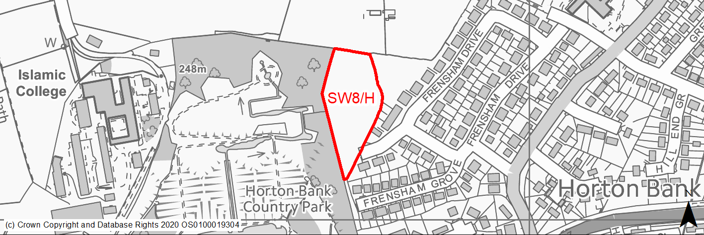
Site location
Regional City - Bradford SW
Ward
Great Horton
Site description
Small sloping field within the green belt but adjoining the built up area, comprising species poor semi improved grassland.
Proposed Allocation
Housing
SHLAA referencce
SW/017
Indicative no. dwellings
26
Site area (Gross) (ha)
0.81
Ownership
Private
Delivery timescales
Developable (6-10 years)
Type (PDL/Greenfield)
Greenfield
Green Belt
Yes
Flood Zone
Flood Zone 1
Potential site access
Access would be from Frensham Drive.
Public Transport Accessibility
Site within 400m of a High Frequency Bus Network
Sustainability Appraisal
The site could deliver a major positive effect for residents on the health SA Objective as a result of being within the target distances for all necessary health facilities. Minor positive effects were predicted for a range of other socio-economic themed SA Objectives due to the benefits of new residential development for the local economy as well as the location of the site in relation to transport links, education facilities and employment areas. No major adverse effects have been predicted for the site, but minor adverse effects were predicted for a range of natural environment themed SA Objectives, primarily as a result of the impacts of new development on a 100% greenfield and Green Belt site which adjoins deciduous woodland priority habitat and TPO woodland. There is a small stream 25m west, which could be impacted by construction and occupation of the site.
Habitats Regulations Assessment
This site falls within 7km of the South Pennine Moors SPA/SAC a HRA must be undertaken to ensure there are no significant effects on these protected sites in terms of recreational pressures. Developments within these zones must comply with Policy SP11; an SPD is being produced to provide further guidance.
Green Belt
See individual Green Belt site assessment in the accompanying report.
Constraints and Opportunities
• The site is considered moderately sensitive in landscape terms in that it adjoins and provides a green backdrop to the adjoining park and is in an elevated position and thus may be visible in some longer distance views. However, the site forms a small element of such views which in any case includes the adjoining built up area.
• A very small part at the extreme NE corner of the site is covered by a group TPO - that TPO woodland area lies to the N of the site.
• The site is not within the S Pennine Moors SPA / SAC however is within Zone C (within 7KM) which requires consideration of potential impacts relating to recreation pressures.
• There are some very small pockets within the site which lie within an area identified on the GIS layer as being subject to 1/1000 year surface water flood risk however the draft SFRA indicates that the risks are not significant.
Development considerations
• Trees covered by TPO should be retained and additional planting included in the scheme to soften and mitigate landscape impacts.
Conclusion/Summary
This site lies within the green belt but is well contained by existing development and lies in a sustainable location. With suitable landscaping and boundary treatment it would form an appropriate small housing site.
(4) SW9/H - South of Highgate Road
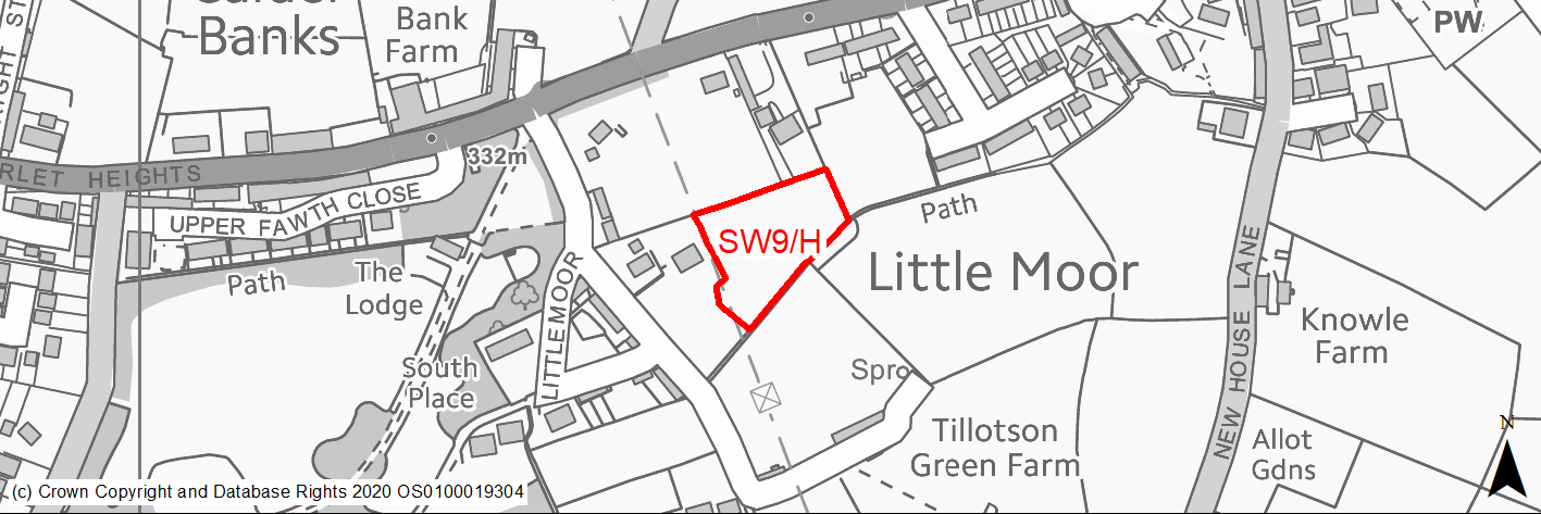
Site location
Regional City - Bradford SW
Ward
Queensbury
Site description
Greenfield site comprising improved grassland and boundary trees, which adjoins two plots which have PP for residential development to the N and E.
Proposed Allocation
Housing
SHLAA referencce
SW/021B
Indicative no. dwellings
14
Site area (Gross) (ha)
0.44
Ownership
Private
Delivery timescales
Developable (6-10 years)
Type (PDL/Greenfield)
Greenfield
Green Belt
No
Flood Zone
Flood Zone 1
Potential site access
Access would need to be gained from adjoining development site to the North.
Public Transport Accessibility
Site within 400m of a High Frequency Bus Network
Sustainability Appraisal
No significant adverse effects predicted for this site. Minor adverse effects predicted for most natural environment themed SA Objectives, primarily as a result of the effects associated with development on greenfield. Site is well located to provide residents with good access to shops, jobs, buses, cultural spaces, schools, and health facilities.
Habitats Regulations Assessment
This site falls within 7km of the South Pennine Moors SPA/SAC a HRA must be undertaken to ensure there are no significant effects on these protected sites in terms of recreational pressures. Developments within these zones must comply with Policy SP11; an SPD is being produced to provide further guidance.
Green Belt
N/A – Site not within the Green Belt.
Constraints and Opportunities
• The site lies within the 200M buffer zone of overhead power line.
• The site contains some habitats which are of value - hedgerow & mixed deciduous woodland.
• Not within the S Pennine Moors SPA / SAC however within Zone C (within 7KM) which requires consideration of potential impacts relating to recreation pressures.
• Lies within the Great Northern Trail and Shibden Green Infrastructure Corridor identified by Natural England.
• Access would need to be gained from adjoining development site to the North.
Development considerations
• Development should seek to retain trees and hedgerows and incorporate further planting to soften the edge of the development.
• Access would need to be gained from adjoining development site to the North.
Conclusion/Summary
A greenfield site within Pool 1 (lowest flood risk and within the urban area). A sustainable location for residential development.
(5) SW10/H - Stocks Lane, Old Dolphin, Clayton Heights
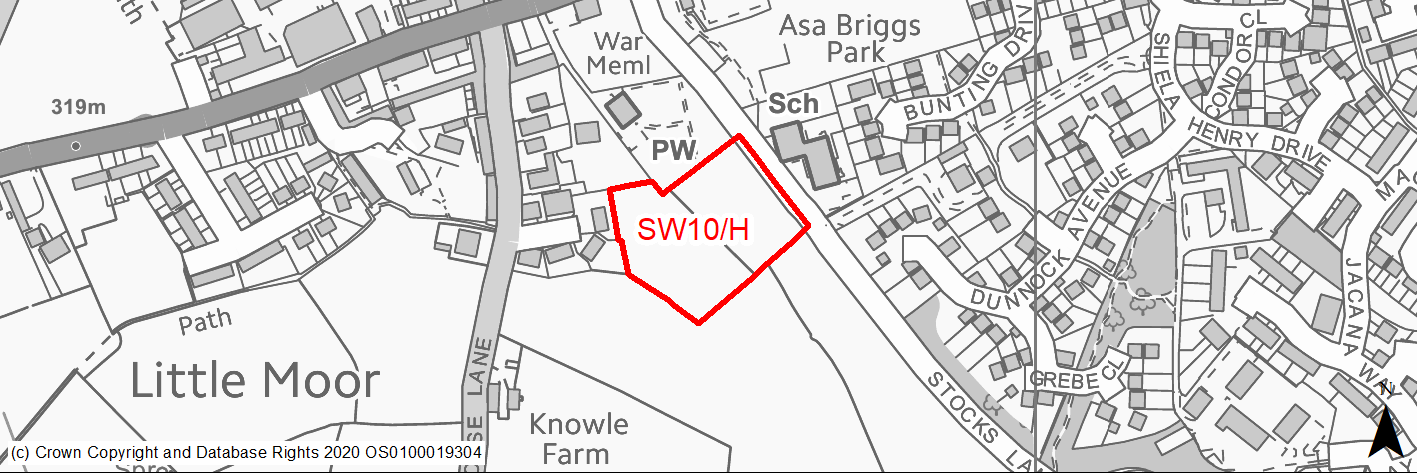
Site location
Regional City - Bradford SW
Ward
Queensbury
Site description
Level field within the green belt adjoined by the settlement edge and by Stocks Lane Primary School.
Proposed Allocation
Housing
SHLAA referencce
SW/022
Indicative no. dwellings
26
Site area (Gross) (ha)
0.83
Ownership
Private
Delivery timescales
Developable (6-10 years)
Type (PDL/Greenfield)
Greenfield
Green Belt
Yes
Flood Zone
Flood Zone 1
Potential site access
Access would be from Stocks Lane which is narrow. Scheme would have to include improvements e.g. traffic calming, parking bays to mitigate for school traffic and new or improved pedestrian footways.
Public Transport Accessibility
Site within 400m of a High Frequency Bus Network
Sustainability Appraisal
Development at this site would be unlikely to result in a significant effect, either positive or negative, on any SA Objective. Minor positive effects were predicted for most socio-economic themed SA Objectives due to the benefits of new residential development for the local economy as well as the location of the site in relation to transport links, health and education facilities, and employment areas, although residents may need to travel beyond the target distance to access services and amenities. As an open greenfield and Green Belt site, the development has been predicted to result in minor adverse effects on most natural environment themed SA Objectives. There are 14 Grade II Listed Buildings within 260m of the site; development here has the potential to adversely alter the settings of these sensitive heritage assets, although this may be limited by the presence of screening vegetation and built form.
Habitats Regulations Assessment
This site falls within 7km of the South Pennine Moors SPA/SAC a HRA must be undertaken to ensure there are no significant effects on these protected sites in terms of recreational pressures. Developments within these zones must comply with Policy SP11; an SPD is being produced to provide further guidance.
Green Belt
See individual Green Belt site assessment in the accompanying report.
Constraints and Opportunities
• The site would be accessed from Stocks Lane which is narrow and any scheme would need to consider highway impacts and suitable mitigations.
• There are several listed buildings located at a distance from the site, to the N and NW however due to distance and intervening built form these are unlikely to impact significantly upon the setting of the heritage assets and any impact is likely to be able to be mitigated through sensitive design, layout etc.
• The site is not within the S Pennine Moors SPA / SAC however is within Zone C (within 7KM) which requires consideration of potential impacts relating to recreation pressures.
Development considerations
• Access will be from Stock Lane and will need to include measures to facilitate traffic calming and the safe movement of vehicles and pedestrians particularly during the school drop off and collection times. Parking bays and improved pedestrian footways may be necessary.
• Landscaping and planting to soften the edge of development.
Conclusion/Summary
The site lies on the edge of Clayton Heights in a sustainable location. Although within the green belt it is well contained between existing residential development and the school. It could be developed with relatively modest landscape and green belt impacts but careful consideration will need to be given access arrangements.
(1) SW11/H - Dirkhill Road
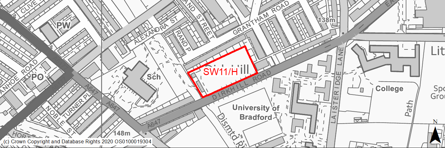
Site location
Regional City - Bradford SW
Ward
City
Site description
Flat site overgrown with scrubby grass and tree cover and some tipping evident. Former garage land.
Proposed Allocation
Housing
SHLAA referencce
SW/029
Indicative no. dwellings
50
Site area (Gross) (ha)
0.73
Ownership
Private
Delivery timescales
Developable (6-10 years)
Type (PDL/Greenfield)
Greenfield
Green Belt
No
Flood Zone
Flood Zone 1
Potential site access
Suitable access can be achieved from Dirkhill Road which will need to accommodate slight change in levels between the road and site.
Public Transport Accessibility
Site within 400m of a High Frequency Bus Network
Sustainability Appraisal
Significant adverse effects predicted for the air quality SA Objective due to the site being within a CAZ. No other significant adverse effects predicted. Minor adverse effects predicted for most natural environment themed SA Objectives, primarily as a result of the effects associated with development on greenfield. The site is predominantly covered in trees, including mature trees. Site is well located to provide residents with good access to shops, jobs, buses, and cultural spaces, with particularly good access to health facilities and schools.
Habitats Regulations Assessment
This site is beyond the zones of influence of the South Pennine Moors SPA/SAC and is therefore unlikely to have any significant effects, a HRA is not required.
Green Belt
N/A – Site not within the Green Belt.
Constraints and Opportunities
• The site contains deciduous woodland / mature trees some of which are protected via a TPO.
• Air quality - the site lies within the draft CAZ.
• Southern part of site lies within a draft green infrastructure corridor.
• The site has been subject to tipping in the past.
Development considerations
• Development should seek to retain protected trees, incorporate habitat enhancement and reflect the sites position on the edge of a green infrastructure corridor.
• Development will need to consider how to mitigate any air quality issues.
• Surveys will be required relating to ecological value and previous tipping and appropriate mitigation measures included in the design process.
Conclusion/Summary
A previously developed site in a sustainable location within Pool 1 (lowest flood risk and within the urban area). Suitable for residential development subject to retention of protected trees.
(2) SW12/H - Horton Park Avenue
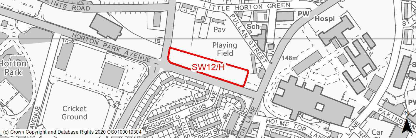
Site location
Regional City - Bradford SW
Ward
City
Site description
Level site, recently used as unsurfaced parking for hospital.
Proposed Allocation
Housing
SHLAA referencce
SW/031
Indicative no. dwellings
24
Site area (Gross) (ha)
0.59
Ownership
Public - NHS Trust
Delivery timescales
Developable (6-10 years)
Type (PDL/Greenfield)
PDL
Green Belt
No
Flood Zone
Flood Zone 1
Potential site access
Access from Horton Park Avenue.
Public Transport Accessibility
Site within 400m of a High Frequency Bus Network
Sustainability Appraisal
Significant adverse effect predicted for the air quality SA Objective, as a result of the site being within the CAZ. No other significant adverse effects predicted. Site would be a good opportunity to delivery biodiversity net gains and improvements to the local character, as well as the setting of the Little Horton Green Conservation Area that is adjacent to the site’s northern perimeter. The site is well located to provide residents with good access to shops, jobs, cultural spaces, and buses, with particularly good access to schools and health facilities.
Habitats Regulations Assessment
This site is beyond the zones of influence of the South Pennine Moors SPA/SAC and is therefore unlikely to have any significant effects, a HRA is not required.
Green Belt
N/A – Site not within the Green Belt.
Constraints and Opportunities
• An opportunity to improve a brownfield site.
• Air quality - the site lies within a CAZ.
• Site adjoins Little Horton Green Conservation Area, affords views of and lies close to Listed Buildings and afford views of All Saints Church - sensitive development required.
• Former landfill and possibly coal mining activity.
Development considerations
• Development design and layout should seek to protect the setting of listed buildings and retain key views of the church.
• Development will need to consider how to mitigate any air quality issues.
• Surveys will be required relating to previous landfill and coal mining activity with appropriate design to mitigate any impacts and risks.
Conclusion/Summary
A previously developed site in a sustainable location within Pool 1 (lowest flood risk and within the urban area). Suitable for residential development subject to sensitive design which reflects its location adjoining Little Horton Green Conservation Area.
(2) SW13/H - Cannon Mills, Cannon Mill Lane / Union Road, Great Horton
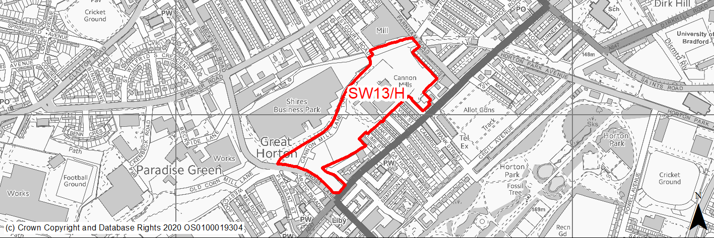
Site location
Regional City - Bradford SW
Ward
City
Site description
Large site comprising 3/4 storey grade II listed mill and extensive, sloping & level surfaces used for parking & Sunday Market. The site is fenced and gated when not in use. The mill buildings are generally vacant. Trees around the perimeter.
Proposed Allocation
Housing
SHLAA referencce
SW/033
Indicative no. dwellings
281
Site area (Gross) (ha)
4.99
Ownership
Private
Delivery timescales
Developable (6-10 years)
Developable (11-18 years)
Type (PDL/Greenfield)
PDL
Green Belt
No
Flood Zone
Flood Zone 1
Potential site access
Access from Beckside Road / Cannon Mill Lane
Public Transport Accessibility
Site within 400m of a High Frequency Bus Network
Sustainability Appraisal
No significant adverse effects predicted for the site. Minor adverse effects predicted for air quality and water resources SA Objectives, as predicted for most sites. SW13/H would be a good opportunity to deliver biodiversity net gains, improvements to the local townscape character and improvements to the setting of local heritage assets, as well as new investment to better preserve the Listed Building within the site which appears to be in disrepair. Site is well located to provide residents here with good access to shops, jobs, cultural spaces, and buses, with particularly good access to schools and health facilities.
Habitats Regulations Assessment
This site is beyond the zones of influence of the South Pennine Moors SPA/SAC and is therefore unlikely to have any significant effects, a HRA is not required.
Green Belt
N/A – Site not within the Green Belt.
Constraints and Opportunities
• An opportunity to improve a brownfield site and retain, enhance and re-use an iconic listed mill.
• Development would assist in regeneration of the local area.
• Cannon Mills is a Grade II Listed building as are the adjoin terraces.
• The site's northern boundary adjoins an area focused on Thornton Road which has been identified as having high NO2 levels.
Development considerations
• Any scheme would need to retain and convert the mill and sensitively incorporate development around the site, maintaining the setting of the listed buildings.
• A Landscape and Visual Impact Assessment will need to be carried out.
Conclusion/Summary
A previously developed site in a sustainable location within Pool 1 (lowest flood risk and within the urban area). Given sensitive design its development provides an opportunity to re-use an iconic building and regenerate the area.
(32) SW14/H - Fenwick Drive, Woodside
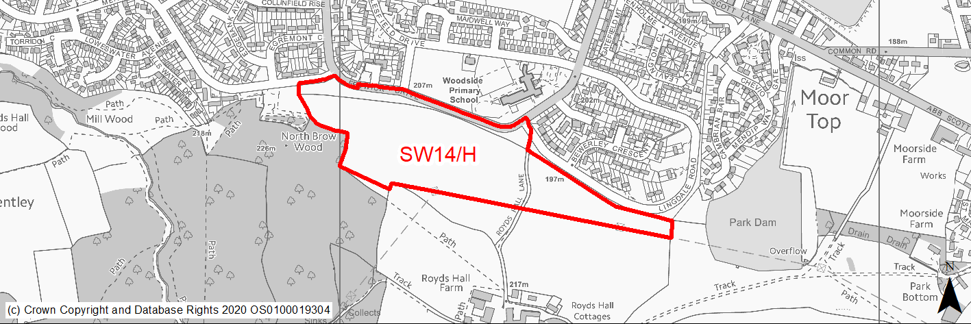
Site location
Regional City - Bradford SW
Ward
Royds
Site description
Sloping improved grassland rising to the south from Fenwick Drive. Site was allocated for residential development in the RUDP.
Proposed Allocation
Housing
SHLAA referencce
SW/034A
Indicative no. dwellings
200
Site area (Gross) (ha)
7.8
Ownership
Private
Delivery timescales
Developable (6-10 years)
Type (PDL/Greenfield)
Greenfield
Green Belt
No
Flood Zone
Flood Zone 1
Potential site access
Size and linear shape of site will require more than one access point from Lingdale Road and Fenwick Drive.
Public Transport Accessibility
Site adjoins a High Frequency Bus Network
Sustainability Appraisal
No significant adverse effects predicted for the site. Minor adverse effects predicted for most natural environment themed SA Objectives, primarily as a result of the effects associated with development on greenfield. There could potentially be a minor adverse effect on the setting of the Grade II* Listed Building ‘Royd’s Hall’. Site is well located to provide residents here with good access to buses, cultural spaces, jobs, schools, and health facilities. Residents may need to travel over 600m to access some shops.
Habitats Regulations Assessment
This site is beyond the zones of influence of the South Pennine Moors SPA/SAC and is therefore unlikely to have any significant effects, a HRA is not required.
Green Belt
N/A – Site not within the Green Belt.
Constraints and Opportunities
• Site is located a short distance to the N of Royds Hall, a Grade II* LB - while not in the immediate setting careful layout and design will be required.
• The site adjoins some important woodland areas - Old Hanna / Low Woods ancient and semi natural woodland and Judy Woods Local Wildlife Site.
• Overhead power line forms / runs along the southern boundary of the site - all bar the far western section of the site lie within the 200M buffer zone of the power line.
• The site contains some habitats / hedgerows which are of value, the western half is identified as semi improved neutral grassland.
• Part of the site is categorised as being of high risk for former coal mining activities including possible mine entry shafts.
Development considerations
• Sensitive layout and design required to avoid impacts on the setting of Royds Hall.
• Development should incorporate buffer areas and suitable planting to avoid impacts on sensitive woodland and habitat areas.
• Overhead power line - will either require a sizeable easement or moving underground.
• Surveys required to investigate and mitigate for any issues relating to former mining and landfill activities.
Conclusion/Summary
A greenfield site within Pool 1 (lowest flood risk and within the urban area). A sustainable location for residential development but will require sensitive design to avoid and mitigate impacts.
(1) SW15/H - Thornton Road/Munby Street
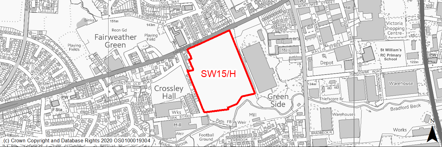
Site location
Regional City - Bradford SW
Ward
Great Horton
Site description
Large cleared brownfield site adjacent to the road. Formerly the site of Fairweather Green Mills. Overgrown and unsightly.
Proposed Allocation
Housing
SHLAA referencce
SW/035
Indicative no. dwellings
175
Site area (Gross) (ha)
6.82
Ownership
Private
Delivery timescales
Deliverable (0-5 years)
Developable (6-10 years)
Type (PDL/Greenfield)
PDL
Green Belt
No
Flood Zone
Majority of site lies in Flood Zone 1, parts of the Eastern half are within Flood Zone 2 and a very small area at the southern boundary lies within Flood Zone 3/3b.
Potential site access
Access from Thornton Road.
Public Transport Accessibility
Site within 400m of a High Frequency Bus Network
Sustainability Appraisal
See individual Sustainability Appraisal site comment in the accompanying report.
Habitats Regulations Assessment
This site is beyond the zones of influence of the South Pennine Moors SPA/SAC and is therefore unlikely to have any significant effects, a HRA is not required.
Green Belt
N/A – Site not within the Green Belt.
Constraints and Opportunities
• An opportunity to improve and re-use a derelict brownfield site and regenerate the local area.
• Some parts in the eastern half lie within zone 2 and part of the site's southern boundary adjoins an area of flood zone 3. Surface water flood risk also affects small areas within the site.
• Listed building to the south of the site;
• The site lies within a green infrastructure corridor.
• The site's northern boundary adjoins an area focused on Thornton Road which has been identified as having high NO2 levels.
Development considerations
• Flood risk mitigation.
• Design which avoids or mitigates impacts on the listed building to the south of the site.
• Incorporation of quality open space and planting to reflect the site's position within a green infrastructure corridor.
• Development will need to consider how to mitigate any air quality issues.
Conclusion/Summary
A previously developed site in a sustainable location which would assist in local regeneration. Mostly flood zone 1. Suitable for residential development subject to mitigation of any issues relating to listed buildings and flood risk and incorporation of new and enhanced greenspace.
(2) SW16/H - Cottam Avenue
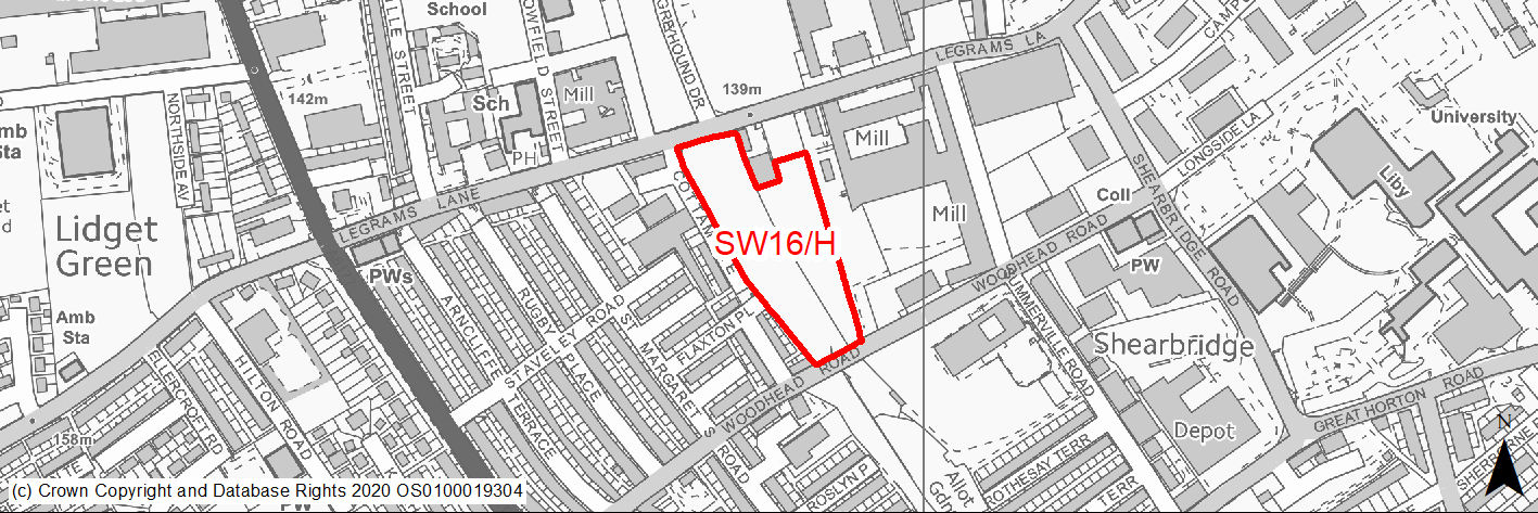
Site location
Regional City - Bradford SW
Ward
City
Site description
Level vacant, cleared site, unsightly and subject to tipping. Overlooked by listed mill and housing.
Proposed Allocation
Housing
SHLAA referencce
SW/036
Indicative no. dwellings
57
Site area (Gross) (ha)
1.55
Ownership
Private
Delivery timescales
Developable (6-10 years)
Type (PDL/Greenfield)
PDL
Green Belt
No
Flood Zone
Flood Zone 1
Potential site access
Access via Cottam Avenue or Legrams Lane
Public Transport Accessibility
Site within 400m of a High Frequency Bus Network
Sustainability Appraisal
See individual Sustainability Appraisal site comment in the accompanying report.
Habitats Regulations Assessment
This site is beyond the zones of influence of the South Pennine Moors SPA/SAC and is therefore unlikely to have any significant effects, a HRA is not required.
Green Belt
N/A – Site not within the Green Belt.
Constraints and Opportunities
• Air quality - the site lies within a CAZ and the site's northern boundary adjoins Legrams Lane which has been identified as having high NO2 levels.
• Former railway cutting along western side of site where tipping has taken place.
• Listed building to the east of the site.
• Most of the site lies within a green infrastructure corridor.
Development considerations
• Development design and layout should seek to protect the setting of nearby listed building;
• Development will need to consider how to mitigate any air quality issues.
• Surveys will be required relating to previous tipping.
Conclusion/Summary
A previously developed site in a sustainable location within Pool 1 (lowest flood risk and within the urban area). Given sensitive design its development provides an opportunity to regenerate the area.
(3) SW17/H - Briggella Mills, Little Horton Lane
Site location
Regional City - Bradford SW
Ward
Little Horton
Site description
Unsightly and overgrown vacant land and prominent 4/5 storey mill buildings suitable for conversion.
Proposed Allocation
Housing
SHLAA referencce
SW/043
Indicative no. dwellings
200
Site area (Gross) (ha)
1.81
Ownership
Private
Delivery timescales
Developable (6-10 years)
Type (PDL/Greenfield)
PDL
Green Belt
No
Flood Zone
Flood Zone 1
Potential site access
There are several options for access to this site.
Public Transport Accessibility
Site within 400m of a High Frequency Bus Network
Sustainability Appraisal
See individual Sustainability Appraisal site comment in the accompanying report.
Habitats Regulations Assessment
This site is beyond the zones of influence of the South Pennine Moors SPA/SAC and is therefore unlikely to have any significant effects, a HRA is not required.
Green Belt
N/A – Site not within the Green Belt.
Constraints and Opportunities
• A brownfield site - potential for a landmark re-development which could assist in regeneration of the area.
• Air quality issues - the site lies within draft Clean Air Zone.
• Need a sensitive design to conserve this undesignated heritage asset.
Development considerations
• Quality design which retains and enhances this undesignated heritage asset.
• Incorporation of quality open space.
• Development will need to consider how to mitigate any air quality issues.
Conclusion/Summary
A previously developed site in a sustainable location within Pool 1 (lowest flood risk and within the urban area). Given sensitive design its development provides an opportunity to regenerate the area.
(9) SW18/H - Fall Top Farm, Brook Lane, Clayton
Site location
Regional City - Bradford SW
Ward
Clayton and Fairweather Green
Site description
Green belt site on the n edge of Clayton comprising slightly undulating semi improved pasture.
Proposed Allocation
Housing
SHLAA referencce
SW/045 (part of)
Indicative no. dwellings
120
Site area (Gross) (ha)
7.8
Ownership
Private
Delivery timescales
Developable (6-10 years)
Developable (11-18 years)
Type (PDL/Greenfield)
Greenfield
Green Belt
Yes
Flood Zone
Flood Zone 1
Potential site access
Site would be accessed via SW3/H. Options for a new road serving this and sites SW3/H, SW4/H and SW22/H from Baldwin Lane to be investigated.
Public Transport Accessibility
Site within 400m of a High Frequency Bus Network
Sustainability Appraisal
See individual Sustainability Appraisal site comment in the accompanying report.
Habitats Regulations Assessment
This site falls within 7km of the South Pennine Moors SPA/SAC a HRA must be undertaken to ensure there are no significant effects on these protected sites in terms of recreational pressures. Developments within these zones must comply with Policy SP11; an SPD is being produced to provide further guidance.
Green Belt
See individual Green Belt site assessment in the accompanying report.
Constraints and Opportunities
• The site could have some landscape impact if development extends to the platform edge.
• The site comprises part of a disused quarry which has been infilled - there are 2 landfill areas one within the site and one just outside and to the south west.
• The site is located in Low Risk Area for coal mining activity and although there are no mine entry shafts indicated within the site, there are 2 shafts indicated to the east of the site.
• Not within the S Pennine Moors SPA / SAC however within Zone C (within 7KM) which requires consideration of potential impacts relating to recreation pressures.
• Access would need to obtained through SW3/H and / or from new road serving SW4/H and SW22/H which joins Baldwin Lane.
• The site can only be accessed through SW3/H.
Development considerations
• No development will be allowed near the platform edge. New houses will be concentrated on the southern half of the site with open space and enhanced planting on the northern part.
• Surveys required to investigate and mitigate for any issues relating to former coal mining and landfill activities.
• The site can be accessed through SW/006. Options for a new road serving this and sites SW3/H, SW4/H and SW22/H from Baldwin Lane to be investigated.
Conclusion/Summary
The is a greenfield site on the edge of Clayton Heights and although within the green belt it lies in a sustainable location. A suitable residential allocation subject to sensitive design and layout which reflects local landscape and topography.
(2) SW19/H - Junction with Park Road, Manchester Road, Little Horton
Site location
Regional City - Bradford SW
Ward
City
Site description
Cleared and level open site adjoining Manchester Road.
Proposed Allocation
Housing
SHLAA referencce
SW/048A
Indicative no. dwellings
22
Site area (Gross) (ha)
0.4
Ownership
Council
Delivery timescales
Developable (6-10 years)
Type (PDL/Greenfield)
PDL
Green Belt
No
Flood Zone
Flood Zone 1
Potential site access
From Park Road.
Public Transport Accessibility
Site within 400m of a High Frequency Bus Network and within 800m of the Interchange Rail Station.
Sustainability Appraisal
Significant adverse effect predicted for air quality SA Objective as a result of the site being within the CAZ. No other significant adverse effects predicted. This PDL site would be a good opportunity to deliver biodiversity net gains and improvements to the local character. Site is well located to provide residents here with good access to shops, jobs, cultural spaces, and health facilities, with particularly good access to schools and public transport options.
Habitats Regulations Assessment
This site is beyond the zones of influence of the South Pennine Moors SPA/SAC and is therefore unlikely to have any significant effects, a HRA is not required.
Green Belt
N/A – Site not within the Green Belt.
Constraints and Opportunities
• A brownfield site and potential for development adjoining a gateway / key corridor close to the city centre which could assist in regeneration of the area.
• Air quality - the site lies within draft CAZ.
• Need a quality design to reflect its location.
Development considerations
• Need for a quality design which reflects the site's location on a key gateway corridor close to the city centre.
• Development will need to consider how to mitigate any air quality issues.
Conclusion/Summary
A previously developed site in a sustainable location which provides the opportunity for a quality / landmark development close to the city centre.
(1) SW20/H - Quaker Lane, Southfield Lane
Site location
Regional City - Bradford SW
Ward
Little Horton
Site description
Flat level grassland within the residential estate surrounded by dwellings.
Proposed Allocation
Housing
SHLAA referencce
SW/052
Indicative no. dwellings
18
Site area (Gross) (ha)
0.39
Ownership
InCommunities
Delivery timescales
Developable (6-10 years)
Type (PDL/Greenfield)
Greenfield
Green Belt
No
Flood Zone
Flood Zone 1
Potential site access
Potential access from Quaker Lane.
Public Transport Accessibility
Site within 400m of a High Frequency Bus Network
Sustainability Appraisal
Significant adverse effect predicted for air quality SA Objective as a result of the site being within the CAZ. No other significant adverse effects predicted. Minor adverse effects predicted for most natural environment themed SA Objectives, primarily as a result of the effects associated with development on greenfield. Site is well located to provide residents with good access to jobs, buses, and cultural spaces, with particularly good access to schools and health facilities. Some residents may be up to 800m from the nearest shops.
Habitats Regulations Assessment
This site is beyond the zones of influence of the South Pennine Moors SPA/SAC and is therefore unlikely to have any significant effects, a HRA is not required.
Green Belt
N/A – Site not within the Green Belt.
Constraints and Opportunities
• The northern half of the site lies within a Low Risk Area and the southern half within a High Risk Area. Coal Authority Mapping indicates a potential mine entry shaft in the eastern part of the site.
• The site lies within the draft Clean Air Zone. An area focused on Hudson Avenue which is identified as having high levels of NO2 lies just to the south.
• Site lies within draft Bradford GI Corridor.
Development considerations
• Surveys required to investigate and mitigate for any issues relating to former mining and landfill activities.
• Development will need to consider how to mitigate any air quality issues.
Conclusion/Summary
A greenfield site within Pool 1 (lowest flood risk and within the urban area). A sustainable location for residential development.
(4) SW21/H - Thornton Road, Leaventhorpe
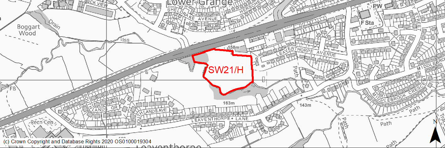
Site location
Regional City - Bradford SW
Ward
Clayton and Fairweather Green
Site description
Level field used as pasture with sloping access from main road. The site adjoins Pitty Beck and is surrounded by trees.
Proposed Allocation
Housing
SHLAA referencce
SW/057
Indicative no. dwellings
51
Site area (Gross) (ha)
1.63
Ownership
Council
Delivery timescales
Developable (6-10 years)
Type (PDL/Greenfield)
Greenfield
Green Belt
No
Flood Zone
The S & W site boundaries are formed by the Pity Beck and these areas of the site lie within Flood Zones 3 or 3b. However the rest of the site - approx 75% of its area lies within Flood Zone 1.
Potential site access
Access is possible from Thornton Road.
Public Transport Accessibility
Site within 400m of a High Frequency Bus Network
Sustainability Appraisal
Significant adverse effect predicted for the climate change resilience SA Objective as a result of the extensive flood risk within the site. No other significant effects predicted. Minor adverse effects predicted for most natural environment themed SA Objectives, primarily as a result of the effects associated with development on greenfield. Site is well located to provide residents with good access to jobs, buses, and cultural spaces, with particularly good access to schools and health facilities. Residents at the site may need to travel up to 1km to access some shops.
Habitats Regulations Assessment
This site falls within 7km of the South Pennine Moors SPA/SAC a HRA must be undertaken to ensure there are no significant effects on these protected sites in terms of recreational pressures. Developments within these zones must comply with Policy SP11; an SPD is being produced to provide further guidance.
Green Belt
N/A – Site not within the Green Belt.
Constraints and Opportunities
• The site is identified as urban greenspace in the RUDP.
• The southern part of the site adjoining Pity Beck lies within flood zone 3 and 3b.
• The site lies within the wildlife habitat network - improved grassland.
• An area designated as a group TPO overlaps v slightly into the NW edge of the site.
• The site lies within the 150M and 250M buffer zones of several former landfill areas.
Development considerations
• No built development should be located in the southern part of the site adjoining Pity Beck and lying within flood zone 3 and 3b.
• The southern part of the site should form a landscape buffer with appropriate planting.
• The trees covered by TPO in the NW corner should be retained.
• The site lies within the 150M and 250M buffer zones of several former landfill areas.
• Surveys required to investigate and mitigate for any issues relating to former landfill activities.
Conclusion/Summary
A greenfield site within the urban area and a sustainable location for residential development but will require sensitive design to avoid and mitigate impacts.
(8) SW22/H - Baldwin Lane, Clayton
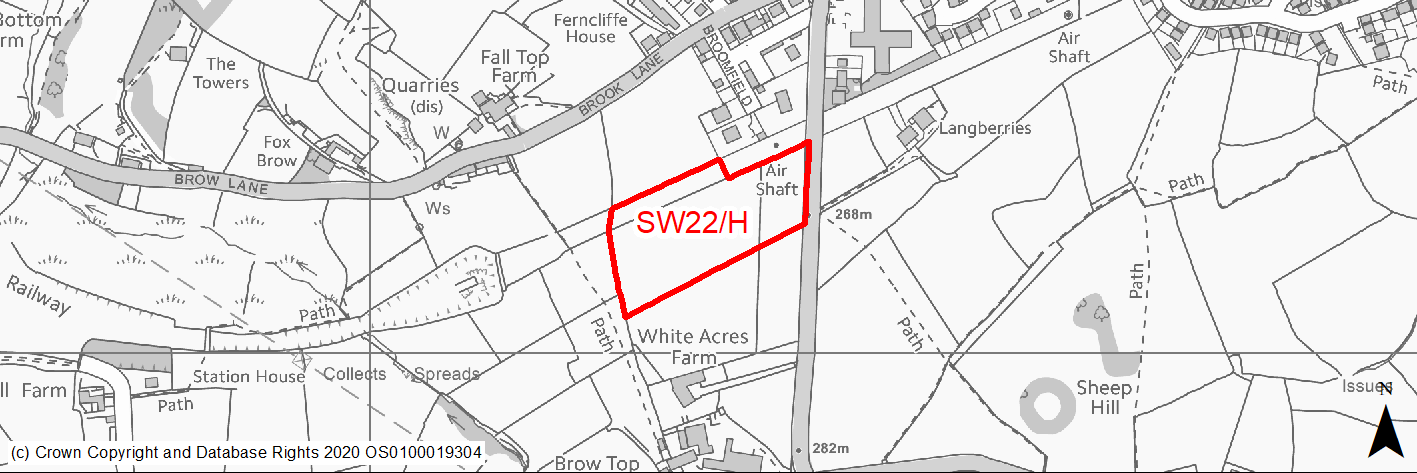
Site location
Regional City - Bradford SW
Ward
Clayton and Fairweather Green
Site description
Open agricultural land within the green belt comprising sloping improved grassland on the southern edge of Clayton.
Proposed Allocation
Housing
SHLAA referencce
SW/059 (part of)
Indicative no. dwellings
57
Site area (Gross) (ha)
2.92
Ownership
Private
Delivery timescales
Developable (6-10 years)
Type (PDL/Greenfield)
Greenfield
Green Belt
Yes
Flood Zone
Flood Zone 1
Potential site access
Site would be accessed from Baldwin Lane. Comprehensive approach to road access and road improvements needed - options for a new road serving this and sites SW3/H, SW4/H and SW18/H to be investigated.
Public Transport Accessibility
Site within 400m of a High Frequency Bus Network
Sustainability Appraisal
See individual Sustainability Appraisal site comment in the accompanying report.
Habitats Regulations Assessment
This site falls within 7km of the South Pennine Moors SPA/SAC a HRA must be undertaken to ensure there are no significant effects on these protected sites in terms of recreational pressures. Developments within these zones must comply with Policy SP11; an SPD is being produced to provide further guidance.
Green Belt
See individual Green Belt site assessment in the accompanying report.
Constraints and Opportunities
• There are several listed buildings located to the NE and S however it is considered likely that any impacts could be mitigated through sensitive design, layout, scale, materials etc.
• Lies within the 150M or 250M buffer zones of several former landfill areas
• Site is located in Low Risk Area for past coal mining activities. There are no mine entry shafts indicated within the site, however there are 2 shafts indicated to the west of the site.
• Not within the S Pennine Moors SPA / SAC however within Zone C (within 7KM) which requires consideration of potential impacts relating to recreation pressures.
• Lies within the Great Northern Trail and Shibden Green Infrastructure Corridor identified by NE. Also lies within a draft Bradford GI Opportunity Corridor.
• The site can only be accessed from Baldwin Lane - consideration will need to be given to transport assessments and improvements which take account of this site and the cumulative impacts of all proposed land releases in this area.
Development considerations
• Development should include landscaping and planting to soften the settlement edge.
• Surveys required to investigate and mitigate for any issues relating to former coal mining and landfill activities.
• Access from Baldwin Lane. Options for a new road serving this and sites SW3/H, SW4/H and SW18/H from Baldwin Lane to be investigated.
Conclusion/Summary
The is a greenfield site on the edge of Clayton Heights and although within the green belt it lies in a sustainable location. A suitable residential allocation subject to sensitive design and layout and highway improvements which the cumulative impact of this and other nearby sites.
(2) SW23/H - Northside Road, Girlington
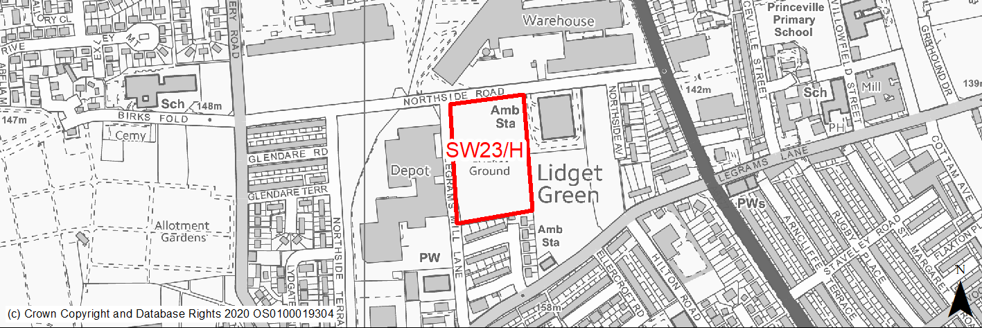
Site location
Regional City - Bradford SW
Ward
City
Site description
Vacant under used, scrubby and poorly maintained green field site which was formerly used as playing fields to south side of road.
Proposed Allocation
Housing
SHLAA referencce
SW/060
Indicative no. dwellings
60
Site area (Gross) (ha)
1.67
Ownership
Private
Delivery timescales
Developable (6-10 years)
Type (PDL/Greenfield)
Greenfield
Green Belt
No
Flood Zone
Flood Zone 1
Potential site access
Access is available from Northside Road.
Public Transport Accessibility
Site within 400m of a High Frequency Bus Network
Sustainability Appraisal
No significant adverse effects predicted for this site. Minor adverse effects predicted for most natural environment themed SA Objectives, primarily as a result of the effects associated with development on greenfield. Site is well located to provide residents with good access to shops, jobs, buses, cultural spaces, and health facilities, with particularly good access to schools.
Habitats Regulations Assessment
This site is beyond the zones of influence of the South Pennine Moors SPA/SAC and is therefore unlikely to have any significant effects, a HRA is not required.
Green Belt
N/A – Site not within the Green Belt.
Constraints and Opportunities
• Site identified as playing fields in the RUDP and formerly used as such. There is a shortage of open space in Bradford SW in a number of typologies.
Development considerations
• Masterplanning of site and area in conjunction with sites SW24/H, SW40/H (and SHLAA site SW/061A).
• Potential need to provide some compensatory open space.
Conclusion/Summary
A greenfield site within Pool 1 (lowest flood risk and within the urban area) and a sustainable location for residential development together with recreation space.
(1) SW24/H - Northside Road, Girlington
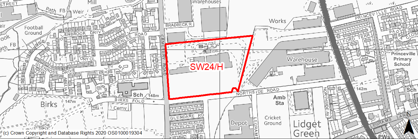
Site location
Regional City - Bradford SW
Ward
Great Horton
Site description
Cleared and derelict site formerly occupied by factories and industrial uses.
Proposed Allocation
Housing
SHLAA referencce
SW/061B
Indicative no. dwellings
151
Site area (Gross) (ha)
4.47
Ownership
Private
Delivery timescales
Developable (6-10 years)
Type (PDL/Greenfield)
PDL
Green Belt
No
Flood Zone
Flood Zone 1
Potential site access
Access is available from Northside Road.
Public Transport Accessibility
Site lies just outside 400m of a High Frequency Bus Network. There are closer bus stops with less frequent services.
Sustainability Appraisal
No significant adverse effects predicted for this site. This PDL site would be a good opportunity to deliver biodiversity net gains and improvements to the local character. Site is well located to provide residents here with good access to shops, jobs, buses, cultural spaces, and health facilities, with particularly good access to schools.
Habitats Regulations Assessment
This site is beyond the zones of influence of the South Pennine Moors SPA/SAC and is therefore unlikely to have any significant effects, a HRA is not required.
Green Belt
N/A – Site not within the Green Belt.
Constraints and Opportunities
• Development would improve an open derelict site and regenerate the area.
• Some small areas are subject surface water flooding.
• Masterplanning in conjunction with adjoining sites would be beneficial.
Development considerations
• Masterplanning in conjunction with adjoining sites would be beneficial.
Conclusion/Summary
A previously developed site within Pool 1 (lowest flood risk and within the urban area and a sustainable location for residential development. An opportunity to re-use and improve a derelict site.
(10) SW25/H - Lingdale Road, Woodside
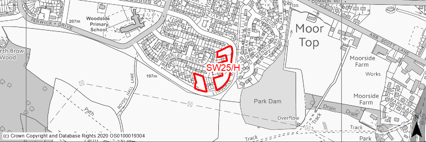
Site location
Regional City - Bradford SW
Ward
Royds
Site description
Site of former flats now cleared, levelled and grassed.
Proposed Allocation
Housing
SHLAA referencce
SW/065
Indicative no. dwellings
19
Site area (Gross) (ha)
0.61
Ownership
Council
Delivery timescales
Developable (6-10 years)
Type (PDL/Greenfield)
Greenfield
Green Belt
No
Flood Zone
Flood Zone 1
Potential site access
Access available from Lingdale Road.
Public Transport Accessibility
Site within 400m of a High Frequency Bus Network
Sustainability Appraisal
See individual Sustainability Appraisal site comment in the accompanying report.
Habitats Regulations Assessment
This site is beyond the zones of influence of the South Pennine Moors SPA/SAC and is therefore unlikely to have any significant effects, a HRA is not required.
Green Belt
N/A – Site not within the Green Belt.
Constraints and Opportunities
• Potential mine entry shaft / coal workings at NE corner of site.
• The majority of the site lies within the 200M buffer zone of overhead power line.
• The site lies within the outer tier consultation zone for BASF/Nufarm, but the HSE would not advise against the development of the site.
• The southern part of the site lies offers views into the surrounding countryside.
Development considerations
• Development should seek to maintain views into the countryside.
• Surveys to investigate potential mine entry shaft / coal workings will be required.
Conclusion/Summary
A greenfield site in a sustainable location within Pool 1 (lowest flood risk and within the urban area). Suitable for residential development subject to investigation and mitigation of risks and constraints.
(11) SW26/H - Abb Scott Lane, Low Moor
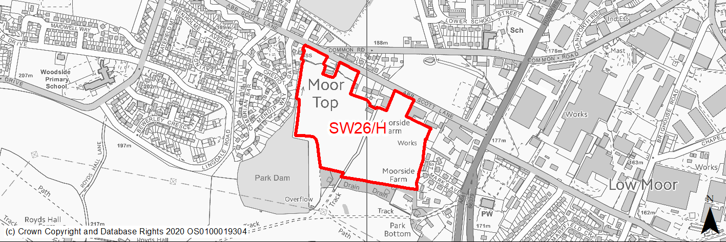
Site location
Regional City - Bradford SW
Ward
Royds
Site description
Level field comprising species poor semi improved grassland with residential properties to the east & north. Mature trees and beck on southern boundary, fishing lake to SW, open land to south.
Proposed Allocation
Housing
SHLAA referencce
SW/066
Indicative no. dwellings
60
Site area (Gross) (ha)
6.77
Ownership
Private
Delivery timescales
Developable (6-10 years)
Type (PDL/Greenfield)
Greenfield
Green Belt
No
Flood Zone
Flood Zone 1
Potential site access
Access is available from Abb Scott Lane.
Public Transport Accessibility
Site within 400m of a High Frequency Bus Network
Sustainability Appraisal
See individual Sustainability Appraisal site comment in the accompanying report.
Habitats Regulations Assessment
This site is beyond the zones of influence of the South Pennine Moors SPA/SAC and is therefore unlikely to have any significant effects, a HRA is not required.
Green Belt
N/A – Site not within the Green Belt.
Constraints and Opportunities
• The site adjoins and is located close to a number of listed buildings along Abb Scott Lane.
• The site currently affords attractive views at several points along Abb Scott lane into the countryside.
• Possible mine entry shafts in the central part of the site and other areas defined as high risk of former coal mining activities in the NW and S of the site.
• The southern half of the site lies within the 200M buffer zone of an overhead power line.
• The whole of the site lies within the middle consultation zone for a HSE designated Major Hazard Site (BASF and Solenis UK Industries) For developments over 30 units HSE would advise against residential development in this location.
Development considerations
• Development should be restricted to a maximum of 30 units.
• Buffer zones should be incorporated around the listed buildings and design, materials and layout formed so as to minimise impact on their setting.
• New dwellings and layout should where possible avoid areas which would remove open views from Abb Scott Lane to the south.
• Access to the dam should be retained / enhanced.
• The development should include substantial areas of open space and landscaping.
• Surveys required to investigate and mitigate for any issues relating to former mining activities.
Conclusion/Summary
A greenfield site within Pool 1 (lowest flood risk and within the urban area). A sustainable location for mixed residential development and enhanced open space but will require sensitive design to avoid and mitigate impacts.
(2) SW27/H - Paradise Fold, Great Horton
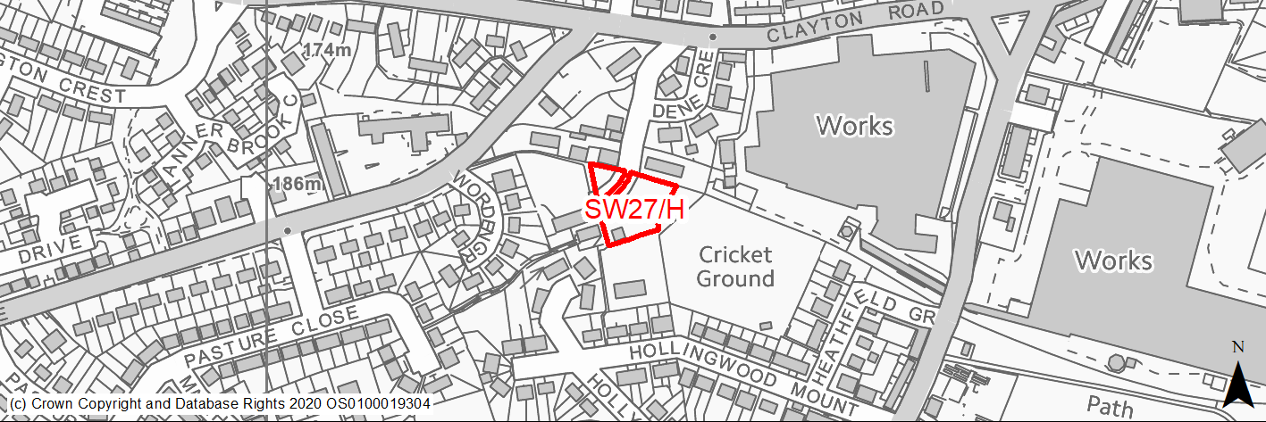
Site location
Regional City - Bradford SW
Ward
Great Horton
Site description
Site in 2 parts adjoining Paradise Farm Public House comprising tipped and uneven grassland and overgrown shrubbery.
Proposed Allocation
Housing
SHLAA referencce
SW/083
Indicative no. dwellings
7
Site area (Gross) (ha)
0.21
Ownership
Private
Delivery timescales
Developable (6-10 years)
Type (PDL/Greenfield)
PDL
Green Belt
No
Flood Zone
Flood Zone 1
Potential site access
Access although available from Dene Crescent and Paradise Fold may need improvements. Paradise Fold is an unadopted highway.
Public Transport Accessibility
Site within 400m of a High Frequency Bus Network
Sustainability Appraisal
See individual Sustainability Appraisal site comment in the accompanying report.
Habitats Regulations Assessment
This site falls within 7km of the South Pennine Moors SPA/SAC a HRA must be undertaken to ensure there are no significant effects on these protected sites in terms of recreational pressures. Developments within these zones must comply with Policy SP11; an SPD is being produced to provide further guidance.
Green Belt
N/A – Site not within the Green Belt.
Constraints and Opportunities
• A previously developed site, development would improve the area.
• Adjoins Paradise Fold PH and cottages which are listed buildings.
• The site lies within the 250M buffer zone for a former landfill.
• The site lies within an area identified on the draft habitat network layer as semi improved grassland habitat.
• Not within the S Pennine Moors SPA / SAC however within Zone C (within 7KM) which requires consideration of potential impacts relating to recreation pressures.
Development considerations
• Design and layout will need to mitigate any impacts on adjoining listed buildings.
• Incorporation of open space and planting to mitigate loss of habitat and enhance local ecology.
Conclusion/Summary
A previously developed site in a sustainable location within Pool 1 (lowest flood risk and within the urban area). Suitable for a small residential development.
(5) SW28/H - Abb Scott Lane, Low Moor
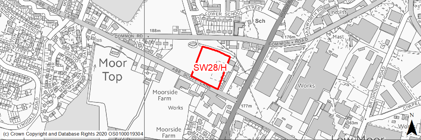
Site location
Regional City - Bradford SW
Ward
Royds
Site description
A mixed part PDL, part greenfield site, formerly playing fields to school (now demolished) on adjacent site. Uneven land which has been fenced to prevent access.
Proposed Allocation
Housing
SHLAA referencce
SW/088
Indicative no. dwellings
30
Site area (Gross) (ha)
1.02
Ownership
Council
Delivery timescales
Developable (6-10 years)
Type (PDL/Greenfield)
Mixed
Green Belt
No
Flood Zone
Flood Zone 1
Potential site access
Access is available from Abb Scott Lane.
Public Transport Accessibility
Site within 400m of a High Frequency Bus Network
Sustainability Appraisal
No significant adverse effects predicted for this site. The site is predominantly PDL but appears to have been almost entirely taken over by nature, and so development here could risk reducing the site’s biodiversity value or local ecological connectivity. At the same time, new development could be an opportunity to enhance the local townscape character given the condition of the site. Site is well located to provide residents here with good access to jobs, cultural spaces, buses, and schools, with particularly good access to health facilities. Residents here may need to travel up to 1.4km for daily shopping needs.
Habitats Regulations Assessment
This site is beyond the zones of influence of the South Pennine Moors SPA/SAC and is therefore unlikely to have any significant effects, a HRA is not required.
Green Belt
N/A – Site not within the Green Belt.
Constraints and Opportunities
• The site lies close to a group of Grade II listed buildings on Abb Scott Lane.
• There is an area in the SW part of the site which has a group TPO designation and a smaller one at the SE edge.
• The whole of the site lies within a High Risk Area of former coal mining activities.
• The whole of the site lies within the middle consultation zone for a HSE designated Major Hazard Site (BASF and Solenis UK Industries). For developments over 30 units HSE would advice against residential development in this location.
Development considerations
• Sensitive use of design, layout and materials is required to mitigate any impacts on the nearby listed buildings.
• Mature trees including those covered by TPO designation should be retained.
• The whole of the site lies within a High Risk Area of former coal mining activities.
• Development should be restricted to a maximum of 30 dwellings.
• Surveys required to investigate and mitigate for any issues relating to former mining activities.
Conclusion/Summary
A mixed Brownfield and greenfield site within Pool 1 (lowest flood risk and within the urban area). A sustainable location for residential development situated between existing housing to the west and east.
(2) SW29/H - Harris Court Mill, Great Horton Road, Great Horton
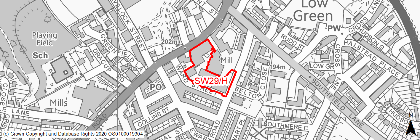
Site location
Regional City - Bradford SW
Ward
Great Horton
Site description
Former prominent mill site, now mostly cleared following fire. Chimney remains.
Proposed Allocation
Housing
SHLAA referencce
SW/098
Indicative no. dwellings
39
Site area (Gross) (ha)
0.57
Ownership
Private
Delivery timescales
Developable (6-10 years)
Type (PDL/Greenfield)
PDL
Green Belt
No
Flood Zone
Flood Zone 1
Potential site access
Access from Great Horton Road.
Public Transport Accessibility
Site within 400m of a High Frequency Bus Network
Sustainability Appraisal
See individual Sustainability Appraisal site comment in the accompanying report.
Habitats Regulations Assessment
This site is beyond the zones of influence of the South Pennine Moors SPA/SAC and is therefore unlikely to have any significant effects, a HRA is not required.
Green Belt
N/A – Site not within the Green Belt.
Constraints and Opportunities
• A brownfield site and potential for development which could assist in regeneration of the area.
• Air quality - high NO2 levels focused on Great Horton Road just to the N of the site.
• Within a conservation area adjoining listed buildings.
• The site lies within a high risk area for former coal mining activities.
• The NE half of the site lies within the 250M buffer zone of a landfill area.
Development considerations
• Design and layout should ensure that any impacts on the CA and listed buildings are avoided / mitigated.
• Development will need to consider how to mitigate any air quality issues.
• Surveys required to investigate and mitigate for any issues relating to former mining and landfill activities.
Conclusion/Summary
A previously developed site in a sustainable location within Pool 1 (lowest flood risk and within the urban area). Suitable for a residential development but requiring a quality scheme reflecting its location within a conservation area.
(3) SW30/H - Brafferton Arbor, Buttershaw
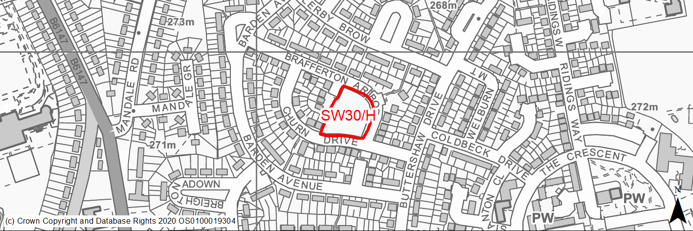
Site location
Regional City - Bradford SW
Ward
Royds
Site description
Level vacant muddy land left over from recent development.
Proposed Allocation
Housing
SHLAA referencce
SW/108
Indicative no. dwellings
14
Site area (Gross) (ha)
0.32
Ownership
Council
Delivery timescales
Developable (6-10 years)
Type (PDL/Greenfield)
Greenfield
Green Belt
No
Flood Zone
Flood Zone 1
Potential site access
Access available from Brafferton Arbour or Church Drive.
Public Transport Accessibility
Site within 400m of a High Frequency Bus Network
Sustainability Appraisal
No significant adverse effects predicted for this site. Minor adverse effects predicted for most natural environment themed SA Objectives, primarily as a result of the effects associated with development on greenfield. Site is well located to provide residents with good access to jobs, buses, and cultural spaces, with particularly good access to schools and health facilities. Residents here may need to travel over 600m for daily shopping needs.
Habitats Regulations Assessment
This site falls within 7km of the South Pennine Moors SPA/SAC a HRA must be undertaken to ensure there are no significant effects on these protected sites in terms of recreational pressures. Developments within these zones must comply with Policy SP11; an SPD is being produced to provide further guidance.
Green Belt
N/A – Site not within the Green Belt.
Constraints and Opportunities
• Existing under used grassed open space
• Lies within a high risk area for former coal mining activities and Coal Authority Mapping indicates that there are multiple possible mine entry shafts just outside the site area.
• Not within the S Pennine Moors SPA however within Zone C (within 7KM) which requires consideration of potential impacts relating to recreation pressures.
Development considerations
• Surveys required to investigate and mitigate for any issues relating to former mining activities.
Conclusion/Summary
A greenfield site in a sustainable location within Pool 1 (lowest flood risk and within the urban area). Suitable for residential development subject to investigation and mitigation of risks and constraints relating to former mine working.
(1) SW31/H - Former Odsal Clinic 55 Odsal Road
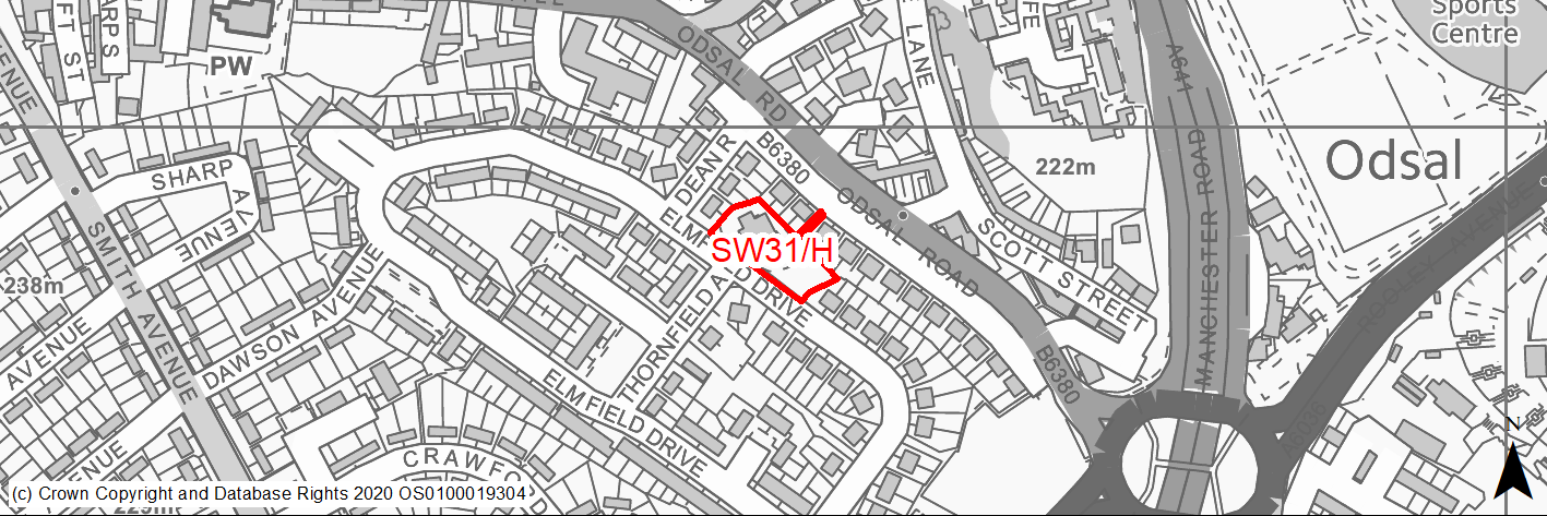
Site location
Regional City - Bradford SW
Ward
Wibsey
Site description
Semi derelict house and associated land.
Proposed Allocation
Housing
SHLAA referencce
SW/119
Indicative no. dwellings
5
Site area (Gross) (ha)
0.21
Ownership
Private
Delivery timescales
Developable (6-10 years)
Type (PDL/Greenfield)
PDL
Green Belt
No
Flood Zone
Flood Zone 1
Potential site access
Access available from Odsal Road
Public Transport Accessibility
Site within 400m of a High Frequency Bus Network
Sustainability Appraisal
No significant adverse effects predicted for the site. This PDL site would be a good opportunity to deliver improvements to the local character. The site appears to be of some biodiversity value in its current condition, which could be jeopardised by new development here. Site is well located to provide residents with good access to shops, jobs, buses, schools, and cultural spaces, with particularly good access to health facilities.
Habitats Regulations Assessment
This site is beyond the zones of influence of the South Pennine Moors SPA/SAC and is therefore unlikely to have any significant effects, a HRA is not required.
Green Belt
N/A – Site not within the Green Belt.
Constraints and Opportunities
• The site lies within a high risk area for former coal mining activities and Coal Authority Mapping indicates that there are multiple possible mine entry shafts just outside the site area.
• The site contains trees which although not protected do provide valued habitat.
• The site lies within the 250M buffer zone for landfill area ref 13se17 - and a small part at the NW corner of the site lies within the 150M buffer zone.
Development considerations
• Surveys required to investigate and mitigate for any issues relating to former mining activities.
• Retention of trees at site boundaries.
Conclusion/Summary
A brownfield site in a sustainable location within Pool 1 (lowest flood risk and within the urban area). Suitable for residential development subject to investigation and mitigation of risks and constraints relating to former mine working and retention of boundary trees.
(5) SW32/H - Church Street, Buttershaw
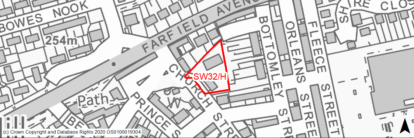
Site location
Regional City - Bradford SW
Ward
Royds
Site description
Brownfield, site comprising derelict building, parking area and unused land adjacent to existing homes.
Proposed Allocation
Housing
SHLAA referencce
SW/122
Indicative no. dwellings
10
Site area (Gross) (ha)
0.15
Ownership
Private
Delivery timescales
Deliverable (0-5 years)
Type (PDL/Greenfield)
PDL
Green Belt
No
Flood Zone
Flood Zone 1
Potential site access
Existing access from Odsal Road.
Public Transport Accessibility
Site within 400m of a High Frequency Bus Network
Sustainability Appraisal
No significant adverse effects predicted for the site. This PDL site would be a good opportunity to deliver biodiversity net gains and improvements to the local character. Site is well located to provide residents here with good access to shops, jobs, cultural spaces, and buses, with particularly good access to schools and health facilities.
Habitats Regulations Assessment
This site is beyond the zones of influence of the South Pennine Moors SPA/SAC and is therefore unlikely to have any significant effects, a HRA is not required.
Green Belt
N/A – Site not within the Green Belt.
Constraints and Opportunities
• A brownfield site and potential for development which could assist in regeneration of the area.
• No significant constraints.
Development considerations
• N/A
Conclusion/Summary
A previously developed site in a sustainable location within Pool 1 (lowest flood risk and within the urban area) suitable for residential development.
(12) SW33/H - Land off Buckingham Crescent, Clayton
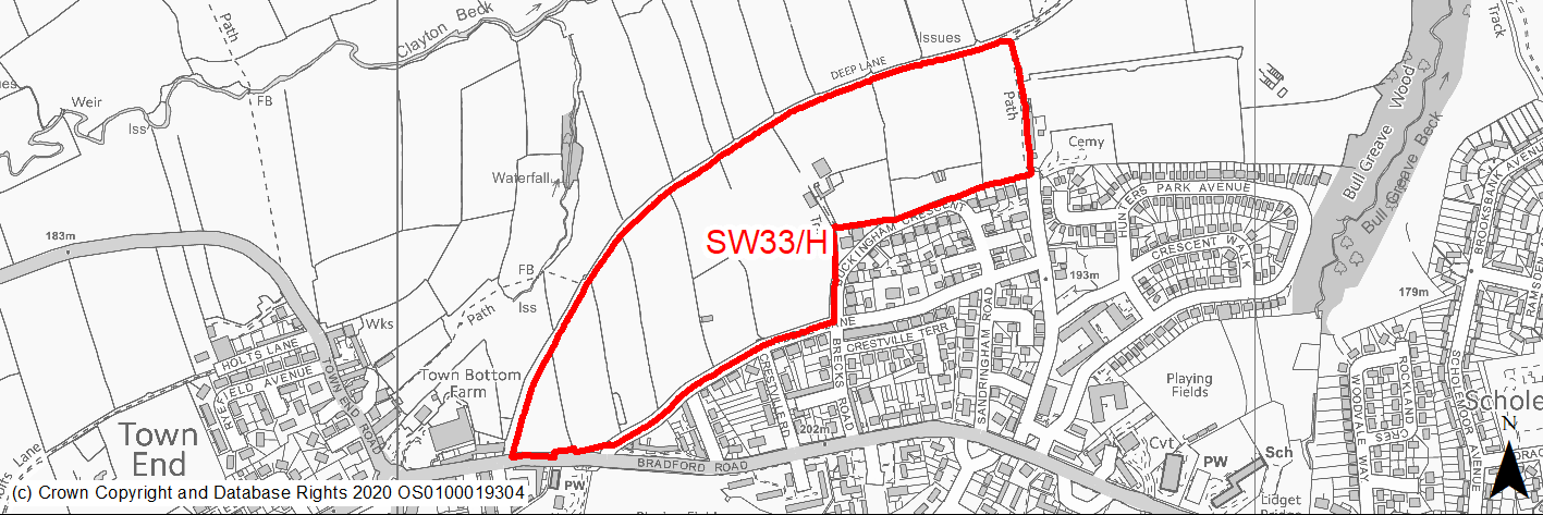
Site location
Regional City - Bradford SW
Ward
Clayton and Fairweather Green
Site description
Agricultural land within the green belt adjoined by the existing built up area to the south and Deep Lane to the North.
Proposed Allocation
Housing
SHLAA referencce
SW/003 & SW/124 (part of)
Indicative no. dwellings
175
Site area (Gross) (ha)
11.8
Ownership
Private/Council
Delivery timescales
Developable (6-10 years)
Type (PDL/Greenfield)
Greenfield
Green Belt
Yes
Flood Zone
Flood Zone 1
Potential site access
There are several potential access points including from Bradford Road in association with site SW1/H or from Brecks Road or Buckingham Crescent.
Public Transport Accessibility
Site within 400m of a High Frequency Bus Network
Sustainability Appraisal
See individual Sustainability Appraisal site comment in the accompanying report.
Habitats Regulations Assessment
This site falls within 7km of the South Pennine Moors SPA/SAC a HRA must be undertaken to ensure there are no significant effects on these protected sites in terms of recreational pressures. Developments within these zones must comply with Policy SP11; an SPD is being produced to provide further guidance.
Green Belt
See individual Green Belt site assessment in the accompanying report.
Constraints and Opportunities
• Site is located immediately to the N/NE of two groups of Grade II listed buildings and to the east of Clayton Conservation Area. The openness of the site (particularly the western section) contributes positively to the setting of the LBs and the CA.
• Parts of the site offer important longer distance views of the valley from the main highway and from public footpaths.
• The majority of the site lies within a low risk area, however coal authority mapping indicates a possible mine entry shaft at the southern edge of the site.
• Not within the S Pennine Moors SPA / SAC however within Zone C (within 7KM) which requires consideration of potential impacts relating to recreation pressures.
Development considerations
• The design and layout of the site should include buffer zones, scale and materials so as to mitigate any impacts on the listed buildings and conservation area and their setting.
• In particular the SW field (SHLAA site SW/003) should be kept predominantly open and enhanced to maintain open views and provide enhanced greenspace.
• Trees and hedgerows to be retained and strengthened with additional open space.
• Access from Bradford Road - options for a new combined access into both this site and site SW1/H will be considered.
Conclusion/Summary
The is a greenfield site on the edge of Clayton and although within the green belt it lies in a sustainable location. A suitable residential allocation subject to sensitive design and landscaping which preserve open views and the setting of key heritage assets.
(12) SW34/H - Meadway, Wibsey
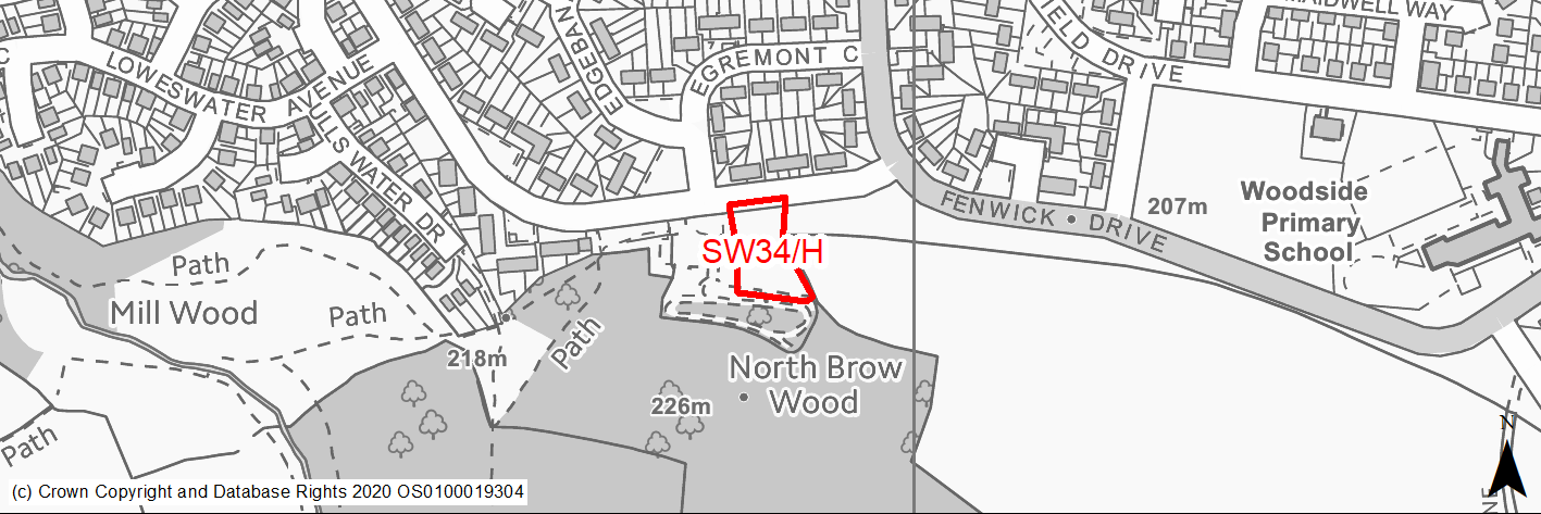
Site location
Regional City - Bradford SW
Ward
Royds
Site description
Unused land comprising grassed area and hardstanding adjoining a play area.
Proposed Allocation
Housing
SHLAA referencce
SW/134
Indicative no. dwellings
7
Site area (Gross) (ha)
0.19
Ownership
Private
Delivery timescales
Developable (6-10 years)
Type (PDL/Greenfield)
Mixed
Green Belt
No
Flood Zone
Flood Zone 1
Potential site access
Access is available from Meadway.
Public Transport Accessibility
Site within 400m of a High Frequency Bus Network
Sustainability Appraisal
No significant adverse effects predicted for this site. Minor adverse effects predicted for most natural environment themed SA Objectives, primarily as a result of the effects associated with development on greenfield, as well as due to the Ancient Woodland and LWS adjoining the site. Site is well located to provide residents with good access to shops, jobs, buses, cultural spaces, health facilities and schools, although the site is not within the target distance of all facilities for any SA Objective (i.e. no major positive scores recorded).
Habitats Regulations Assessment
This site is beyond the zones of influence of the South Pennine Moors SPA/SAC and is therefore unlikely to have any significant effects, a HRA is not required.
Green Belt
N/A – Site not within the Green Belt.
Constraints and Opportunities
• A small part of the site at its southern boundary lies within a area covered by a Group TPO.
• Judy Woods and Old Hanna / Low Woods Ancient and Semi Natural Woodland adjoins the site to the south.
• Opportunity to include the site within masterplan for adjoining site SW14/H.
• In a Low Risk Area for former coal mining activity but there is an indication of a possible mine entry shaft to the SE of the site.
Development considerations
• Development should be designed in conjunction with site SW14/H and should avoid any adverse affects on adjoining woodlands. A buffer area should be incorporated in to the southern section of the site and planted with native trees.
Conclusion/Summary
A mixed previously developed / greenfield site in a sustainable location within Pool 1 (lowest flood risk and within the urban area) suitable for residential development.
(1) SW35/H - All Saints Road
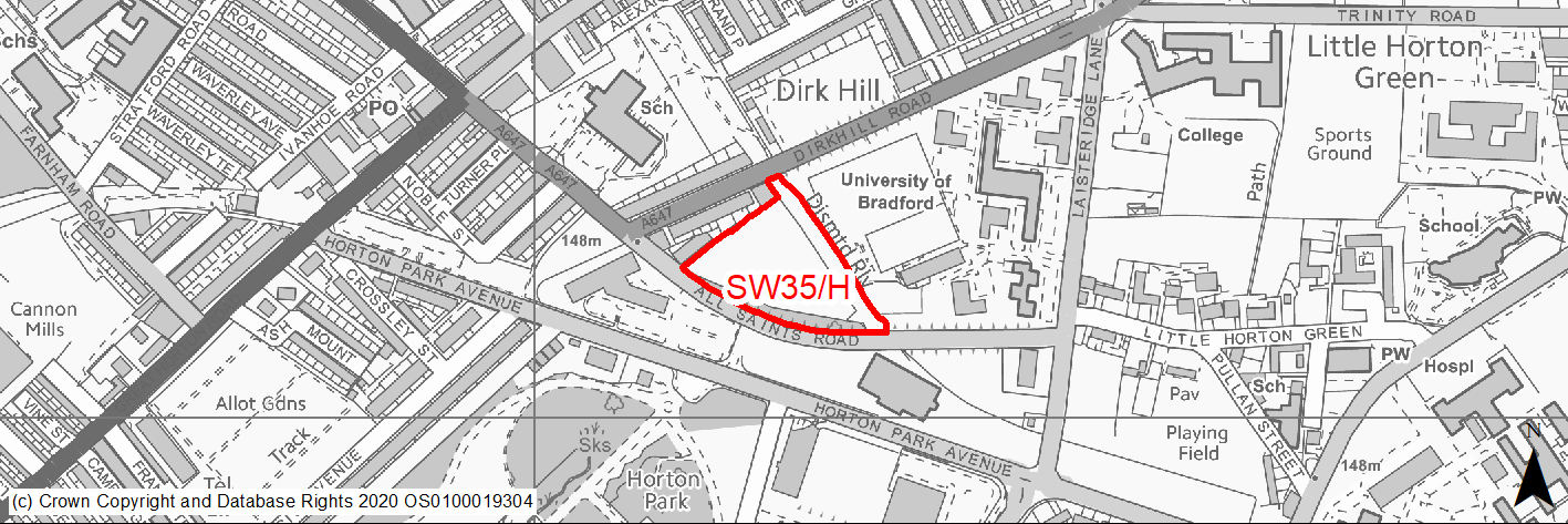
Site location
Regional City - Bradford SW
Ward
City
Site description
Cleared site adjacent to Bradford University. Some development was started for an earlier development which has now been abandoned and the site has become overgrown.
Proposed Allocation
Housing
SHLAA referencce
SW/139
Indicative no. dwellings
50
Site area (Gross) (ha)
1.34
Ownership
Private
Delivery timescales
Developable (6-10 years)
Type (PDL/Greenfield)
Mixed
Green Belt
No
Flood Zone
Flood Zones 1 and 3. Area covered by zone 3 relates to sewer that crosses the site. Application for student accommodation considered acceptable in 2007.
Potential site access
Access is available from All Saints Road.
Public Transport Accessibility
Site within 400m of a High Frequency Bus Network
Sustainability Appraisal
See individual Sustainability Appraisal site comment in the accompanying report.
Habitats Regulations Assessment
This site is beyond the zones of influence of the South Pennine Moors SPA/SAC and is therefore unlikely to have any significant effects, a HRA is not required.
Green Belt
N/A – Site not within the Green Belt.
Constraints and Opportunities
• Opportunity to improve a cleared and semi derelict site and thus contribute to housing need and regeneration.
• Site lies within draft Clean Air Zone.
• The site is partially covered by flood risk 3 which relates to a sewer which crosses the site.
• The site includes a narrow belt of land which is a former landfill site.
• The site lies just to the north of Horton Park which has Historic Parks and Garden classification.
Development considerations
• Buildings will need to avoid the line of the existing sewer.
• Development will need to consider how to mitigate any air quality issues.
• Sensitive design and layout required to reflect the site's location close to Horton Park.
• Mature trees alongside All Saints Road should be retained.
• Surveys required to investigate and mitigate for any issues relating to former landfill activities.
Conclusion/Summary
A mixed previously developed / greenfield site in a sustainable location within the urban area suitable for residential development subject to sensitive design, retention of trees and resolution of any issues relating to the location of the sewer.
(6) SW36/HC - Highgate Road, Clayton Heights
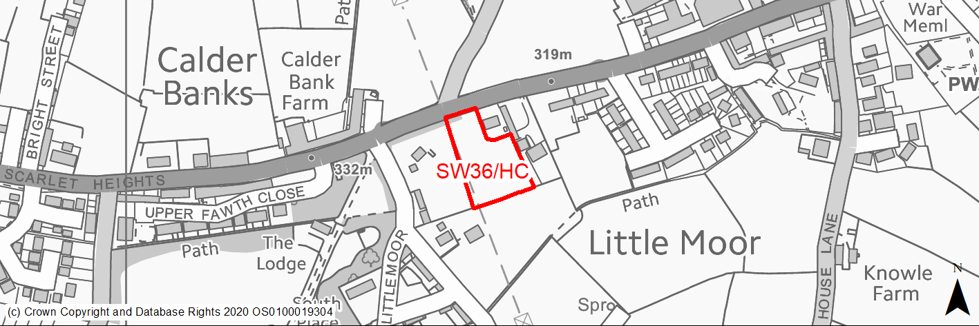
Site location
Regional City - Bradford SW
Ward
Queensbury
Site description
Garden land to rear of detached property - site with outline permission for 5 units.
Proposed Allocation
Housing
SHLAA referencce
SW/142
Indicative no. dwellings
5
Site area (Gross) (ha)
0.4
Ownership
Private
Delivery timescales
Developable (6-10 years)
Type (PDL/Greenfield)
Greenfield
Green Belt
No
Flood Zone
Flood Zone 1
Potential site access
Access would be from Highgate Road.
Public Transport Accessibility
Site within 400m of a High Frequency Bus Network
Sustainability Appraisal
There are unlikely to be any significant effects, either positive or negative, on any SA Objective arising as a result of development at this site.
Minor positive effects were predicted for most socio-economic themed SA Objectives due to the benefits of new residential development for the local economy as well as the location of the site in relation to transport links, health and education facilities and employment areas.
Minor adverse effects have been predicted for a range of natural environment themed SA Objectives, primarily as a result of the impacts of new development on a predominantly greenfield site with containing trees.
Habitats Regulations Assessment
This site falls within 7km of the South Pennine Moors SPA/SAC a HRA must be undertaken to ensure there are no significant effects on these protected sites in terms of recreational pressures. Developments within these zones must comply with Policy SP11; an SPD is being produced to provide further guidance.
Green Belt
N/A – Site not within the Green Belt.
Constraints and Opportunities
• Overhead power line forms / runs along the western boundary of the site - all of the site lie within the 200M buffer zone of the power line.
• • Site lies within the draft Bradford Green Infrastructure Opportunity Corridor.
Development considerations
• Site has outline permission for 5 dwellings.
Conclusion/Summary
A greenfield site within Pool 1 (lowest flood risk and within the urban area) and a sustainable location for a small residential development.
(3) SW37/H - Cousen Road
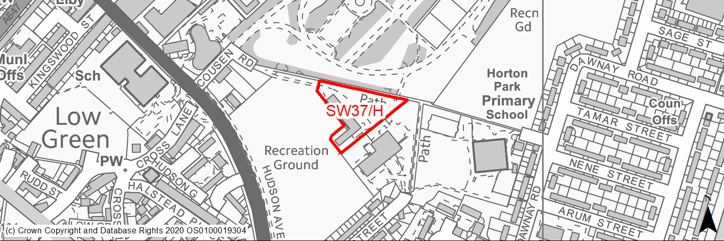
Site location
Regional City - Bradford SW
Ward
Little Horton
Site description
Cleared site immediately south of Horton Park. Formerly occupied by Joseph Nutter House.
Proposed Allocation
Housing
SHLAA referencce
SW/148
Indicative no. dwellings
11
Site area (Gross) (ha)
0.45
Ownership
Private
Delivery timescales
Deliverable (0-5 years)
Type (PDL/Greenfield)
PDL
Green Belt
No
Flood Zone
Flood Zone 1
Potential site access
Access is available from Cousen Road. However improvements will be required in term of widening and pedestrian footways as the road is narrow and unadopted from just beyond the entrance to the park.
Public Transport Accessibility
Site within 400m of a High Frequency Bus Network
Sustainability Appraisal
Significant adverse effect predicted for air quality SA Objective as a result of the site being within the CAZ. No other significant adverse effects predicted. This PDL site would be a good opportunity to deliver improvements to the local character, subject to the implementation of development. Site is adjacent to Horton Park, a Registered Park/Garden, but is entirely bounded by mature trees and so would be unlikely to have a discernible impact on setting. Site is well located to provide residents here with good access to shops, jobs, buses, and cultural spaces, with particularly good access to health facilities and schools.
Habitats Regulations Assessment
This site is beyond the zones of influence of the South Pennine Moors SPA/SAC and is therefore unlikely to have any significant effects, a HRA is not required.
Green Belt
N/A – Site not within the Green Belt.
Constraints and Opportunities
• Opportunity for a quality development in a sustainable location.
• The site adjoins Horton Park, a registered Historic Park & Garden.
• Site lies within draft Clean Air Zone.
• Site lies within a draft GI corridor.
• A small area on the south western edge of the site is indicated on the GIS layer to be subject to surface flood risk.
Development considerations
• A sensitive development which respects the location and setting adjoining Horton Park and which retains mature trees is required.
• Access is available from Cousen Road. However, improvements will be required in term of widening and pedestrian footways as the road is narrow and unadopted from just beyond the entrance to the park.
• Development will need to consider how to mitigate any air quality and flood risk issues.
Conclusion/Summary
The site is suitable for residential development providing sensitive design which reflects its location adjoining Horton Park.
(1) SW38/HC - Dovedale Road, Bankfoot
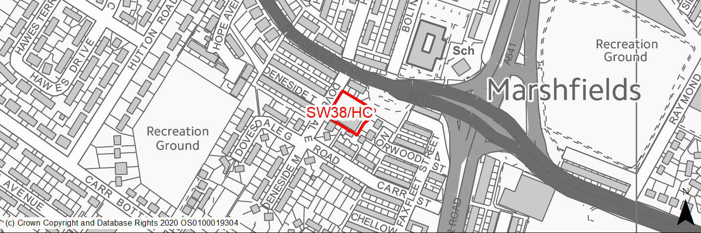
Site location
Regional City - Bradford SW
Ward
Wibsey
Site description
Former working mens club and parking with outline planning permission for 9 houses.
Proposed Allocation
Housing
SHLAA referencce
SW/150
Indicative no. dwellings
9
Site area (Gross) (ha)
0.18
Ownership
Private
Delivery timescales
Developable (6-10 years)
Type (PDL/Greenfield)
PDL
Green Belt
No
Flood Zone
Flood Zone 1
Potential site access
Access is available from Dovedale Road.
Public Transport Accessibility
Site within 400m of a High Frequency Bus Network
Sustainability Appraisal
See individual Sustainability Appraisal site comment in the accompanying report.
Habitats Regulations Assessment
This site is beyond the zones of influence of the South Pennine Moors SPA/SAC and is therefore unlikely to have any significant effects, a HRA is not required.
Green Belt
N/A – Site not within the Green Belt.
Constraints and Opportunities
• The site lies just to the south of the A6177 which has been identified as having high NO2 levels and just outside of the draft Clean Air Zone.
• The site lies within a high risk area for former coal mining activities.
Development considerations
• Surveys required to investigate and mitigate for any issues relating to former mining activities.
• Development will need to consider how to mitigate any air quality issues.
Conclusion/Summary
A previously developed site in a sustainable location within Pool 1 (lowest flood risk and within the urban area) suitable for residential development.
(20) SW39/H - Bowman Road, Wibsey
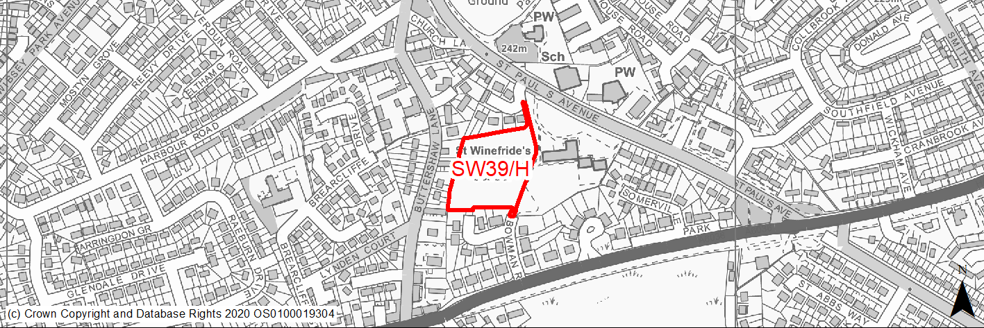
Site location
Regional City - Bradford SW
Ward
Wibsey
Site description
Greenfield site comprising disused playing field, adjoining residential properties to the west and St Winifred's School to the east.
Proposed Allocation
Housing
SHLAA referencce
SW/155
Indicative no. dwellings
44
Site area (Gross) (ha)
1.07
Ownership
Council
Delivery timescales
Developable (6-10 years)
Type (PDL/Greenfield)
Greenfield
Green Belt
No
Flood Zone
Flood Zone 1
Potential site access
Site can be accessed from adopted highway at Bowman Road.
Public Transport Accessibility
Site within 400m of a High Frequency Bus Network
Sustainability Appraisal
No significant adverse effects predicted for this site. Minor adverse effects predicted for most natural environment themed SA Objectives, primarily as a result of the effects associated with development on greenfield. Site is well located to provide residents with good access to shops, jobs, buses, and cultural spaces, with particularly good access to schools and health facilities.
Habitats Regulations Assessment
This site is beyond the zones of influence of the South Pennine Moors SPA/SAC and is therefore unlikely to have any significant effects, a HRA is not required.
Green Belt
N/A – Site not within the Green Belt.
Constraints and Opportunities
• The whole of the site is designated in the RUDP as playing fields.
• Two Grade II listed buildings are located to the N of the site on the opposite side of St Paul's Avenue - any potential impacts could probably be mitigated through good design, sensitive layout and massing, materials etc.
• Much of the site lies within a Low Risk Area for past coal mining. However, there is an area within the centre of the site which is within the high risk area. Coal Authority Mapping does not indicate that there are any mine entry shafts within the site however it does suggest that there are 2 shafts just beyond the site one to the SE and one to the NE.
• The site does lie within the 150M and 250M buffer zones of former landfill area.
• Boundaries contain some trees and hedgerows of value.
• Site can be accessed from adopted highway at Bowman Road.
Development considerations
• Sensitive design required to mitigate any impacts on nearby listed buildings.
• Surveys required to investigate and mitigate for any issues relating to former coal mining and landfill activities.
• Boundaries trees and hedgerows of value should be retained.
• Site can be accessed from adopted highway at Bowman Road.
Conclusion/Summary
A greenfield site within Pool 1 (lowest flood risk and within the urban area) and a sustainable location for a residential development.
(1) SW40/H - Northside Road
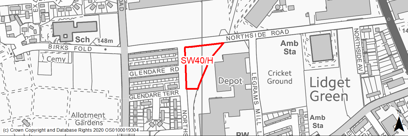
Site location
Regional City - Bradford SW
Ward
City
Site description
Derelict scrubby unused land adjoining Dixons Kings Academy school.
Proposed Allocation
Housing
SHLAA referencce
SW/156
Indicative no. dwellings
19
Site area (Gross) (ha)
0.47
Ownership
Council
Delivery timescales
Developable (6-10 years)
Type (PDL/Greenfield)
PDL
Green Belt
No
Flood Zone
Flood Zone 1
Potential site access
The site has an existing access from Northside Road.
Public Transport Accessibility
Site within 400m of a High Frequency Bus Network
Sustainability Appraisal
No significant adverse effects predicted for this site. This PDL site would be a good opportunity to deliver biodiversity net gains and improvements to the local character. Site is well located to provide residents here with good access to shops, jobs, cultural spaces, and health facilities, with particularly good access to schools.
Habitats Regulations Assessment
This site is beyond the zones of influence of the South Pennine Moors SPA/SAC and is therefore unlikely to have any significant effects, a HRA is not required.
Green Belt
N/A – Site not within the Green Belt.
Constraints and Opportunities
• Development would improve an open derelict site and regenerate the area.
• Masterplanning in conjunction with adjoining sites would be beneficial.
Development considerations
• Masterplanning in conjunction with adjoining sites would be beneficial.
Conclusion/Summary
A previously developed site within Pool 1 (lowest flood risk and within the urban area) and a sustainable location for residential development. An opportunity to re-use and improve a derelict site.
(1) SW41/HC - Blamires Street
Site location
Regional City - Bradford SW
Ward
Great Horton
Site description
Brownfield site consisting of a group of modern and rather untidy workshops and sheds. Outline permission for 9 homes.
Proposed Allocation
Housing
SHLAA referencce
SW/157
Indicative no. dwellings
9
Site area (Gross) (ha)
0.29
Ownership
Private
Delivery timescales
Developable (6-10 years)
Type (PDL/Greenfield)
PDL
Green Belt
No
Flood Zone
Flood Zone 1
Potential site access
Access could be gained from Blamires Place.
Public Transport Accessibility
Site within 400m of a High Frequency Bus Network
Sustainability Appraisal
See individual Sustainability Appraisal site comment in the accompanying report.
Habitats Regulations Assessment
This site is beyond the zones of influence of the South Pennine Moors SPA/SAC and is therefore unlikely to have any significant effects, a HRA is not required.
Green Belt
N/A – Site not within the Green Belt.
Constraints and Opportunities
• A brownfield site where development which could assist in regeneration of the area and improve the setting of adjoining listed building.
• A small part through the centre of the site is subject to surface water flood risk.
• The site is located in a High Risk Area for former coal mining activity.
• The site adjoins / lies within the buffer zone of 2 former landfill areas.
Development considerations
• Surveys required to investigate and mitigate for any issues relating to former mining and landfill activities.
• Design and layout should avoid or mitigate impacts on the adjoining listed building.
Conclusion/Summary
A previously developed site within Pool 1 (lowest flood risk and within the urban area) and a sustainable location for residential development.
(2) SW42/HC - Former Pub, Reevy Road, The Crescent, Buttershaw
Site location
Regional City - Bradford SW
Ward
Royds
Site description
Cleared site of former pub with grassed surrounds. Has outline planning permission for 14 dwellings.
Proposed Allocation
Housing
SHLAA referencce
SW/158
Indicative no. dwellings
14
Site area (Gross) (ha)
0.32
Ownership
Private
Delivery timescales
Developable (6-10 years)
Type (PDL/Greenfield)
Mixed
Green Belt
No
Flood Zone
Flood Zone 1
Potential site access
Access is possible from The Crescent subject to achieving acceptable gradients.
Public Transport Accessibility
Site within 400m of a High Frequency Bus Network
Sustainability Appraisal
No significant adverse effects predicted for this site. This predominantly PDL site would be a good opportunity to deliver biodiversity net gains and improvements to the local character. Site is well located to provide residents here with good access to jobs, cultural spaces, and buses, with particularly good access to schools and health facilities. Residents at the site may need to travel over 600m for daily shopping needs.
Habitats Regulations Assessment
This site is beyond the zones of influence of the South Pennine Moors SPA/SAC and is therefore unlikely to have any significant effects, a HRA is not required.
Green Belt
N/A – Site not within the Green Belt.
Constraints and Opportunities
• A brownfield site where development could assist in regeneration of the area.
• Although most of the site lies within a low risk area for former coal mining activity mapping indicates the potential for a mine entry shaft at the SE corner of the site.
Development considerations
• Surveys required to investigate and mitigate for any issues relating to former mining activities.
Conclusion/Summary
A previously developed site within Pool 1 (lowest flood risk and within the urban area) and a sustainable location for residential development. Has outline permission for 14 homes.
(2) SW43/H - Bell House, Southfield Lane
Site location
Regional City - Bradford SW
Ward
Great Horton
Site description
Brownfield site comprising empty building and parking area and grassed area.
Proposed Allocation
Housing
SHLAA referencce
SW/160
Indicative no. dwellings
9
Site area (Gross) (ha)
0.2
Ownership
Private
Delivery timescales
Developable (6-10 years)
Type (PDL/Greenfield)
PDL
Green Belt
No
Flood Zone
Flood Zone 1
Potential site access
The site has an existing access from Southfield Lane.
Public Transport Accessibility
Site within 400m of a High Frequency Bus Network
Sustainability Appraisal
No significant adverse effects predicted for this site. This predominantly PDL site would be a good opportunity to deliver biodiversity net gains and improvements to the local character. Site is well located to provide residents here with good access to shops, jobs, and cultural spaces, with particularly good access to schools and health facilities.
Habitats Regulations Assessment
This site is beyond the zones of influence of the South Pennine Moors SPA/SAC and is therefore unlikely to have any significant effects, a HRA is not required.
Green Belt
N/A – Site not within the Green Belt.
Constraints and Opportunities
• The re-use and improvement of a vacant and semi derelict site would contribute to the regeneration of the area.
• The site lies within Great Horton Conservation Area.
• The site contains grade II listed building and lies within the 50M buffer of two clusters of grade II listed buildings.
• The central part of the site includes an area identified on the GIS layer as being subject to 1/1000 year surface water flood risk.
Development considerations
• A sensitively designed development which would conserve and enhance the setting of the listed buildings and reflect its position within the conservation area is required.
• Retention of mature trees along site boundaries.
• Mitigation of any surface water flood risk.
Conclusion/Summary
A previously developed site within Pool 1 (lowest flood risk and within the urban area) and a sustainable location for residential development. Development could improve the area and re-use and conserve a heritage asset.