
Draft Bradford District Local Plan - Preferred Options (Regulation 18) February 2021
(1) Appendices
Appendix 1 Glossary of Terms
|
Term |
Definition |
|
Affordable Housing |
This is housing for sale or rent for people whose needs are not by the market (including housing that provides a subsidised route to home ownership and / or is for essential local workers) and which complies with one or more of the following:
|
|
Area Action Plan (AAP) |
A Development Plan Document, which focuses on a specific part of the district. They focus on the implementation of policies towards conservation, change and opportunities (for example a major regeneration project with new housing). |
|
Authorities Monitoring Report (AMR) |
A report produced by a local planning authority that assesses the progress and the effectiveness of specified planning policies in development plan documents. It also includes a review of the Local Development Scheme's timetable. |
|
Brownfield Land |
See Previously Developed Land. |
|
Core Strategy |
This is the key development plan document of the Local Plan which sets out the vision, strategic objectives and strategic policies to guide the pattern and level of development over the 15 year period from adoption. |
|
Core Strategy Partial Review (CSPR) |
The partial review of the Core Strategy is being carried out to review those policies which are now out-of-date due to changes in national planning policy and/or local circumstances. |
|
Development Plan |
The Development Plan sets out the policies and proposals for development and other use of land in the District. It can be a single document or made up of a number of documents including: Local Plans, Development Plan Documents and Neighbourhood Plan. |
|
Development Plan Documents (DPD) |
DPDs are the documents which make up the Local Plan. |
|
Duty-to-Cooperate |
The Localism Act 2011 introduced the duty to cooperate. It requires local planning authorities to cooperate with each other, and with other prescribed bodies, on strategic matters that cross administrative boundaries. |
|
Employment Need Assessment and Land Review (ELR) |
This evidence-base study provides information on the demand for, and the available supply of, land for employment use. It looks at jobs growth and converts this into a land requirement. |
|
Evidence Base |
A collection of technical studies on various topics such as housing, employment, environment, transport. These are used to inform the preparation of the policies in the Local Plan. |
|
Green Belt |
An area of open land defined on the policies map of the Local Plan which has been designated in line with national policy where strict controls are placed on development in order to check the unrestricted sprawl of large built up areas, safeguard the countryside from encroachment, prevent neighbouring towns from margining into one another, preserve the special character of historic towns, and assist in urban regeneration. |
|
Greenfield Land |
Land that has not previously been developed. (Also see definition for Previously Developed Land). |
|
Gypsy and Traveller Community |
Persons of nomadic habit of life whatever their race or origin, including such persons who on grounds only of their own or their family's or dependants' educational or health needs or old age have ceased to travel temporarily, but excluding members of an organised group of travelling showpeople or circus people travelling together as such. |
|
Historic England (HE) |
HE is a public body that helps people care for, enjoy and celebrate England's spectacular historic environment. |
|
Index of Multiple Deprivation (IMD) |
The IMD is a set of six indicators (income; employment; health deprivation and disability; education; skills and training; housing; and geographical access to services) to help identify areas for regeneration, at ward level. |
|
Leeds City Region (LCR) |
The LCR covers 10 districts in West, North and South Yorkshire. The LCR partnership supports the economic development of the area. |
|
Local Enterprise Partnership (LEP) |
A voluntary partnership of local authorities and businesses which are tasked with creating or improving the conditions for economic growth in the area. |
|
Local Development Scheme (LDS) |
This document sets out the timetable for the preparation of the Local Plan. |
|
Local Geodiversity Sites (LGSs) |
LGSs are protected in the same way as important biological sites, to recognise and protect the importance of certain landforms. |
|
Local Housing Need |
The number of homes identified as being needed through the application of the standard method set out in national planning guidance, or a justified alternative approach. |
|
Local Plan |
A plan for the future development of the local area. It provides policies which are used to determine planning applications. It identifies how much development will take place over the next 15 years and where this will occur. It allocates sites to be developed. |
|
Local Planning Authority (LPA) |
The public authority whose duty it is to carry out specific planning functions for a particular area. |
|
Localism Act |
A major piece of new legislation, which includes wide-ranging changes to local government, housing and planning. Significantly, the Act abolishes regional planning, and introduces the possibility of Neighbourhood Plans as part of the development plan. |
|
National Planning Policy Framework (NPPF) |
The NPPF set out the Government's planning policies for England and how these should be applied. It provides a framework within which locally-prepared plans for housing and other development can be produced. |
|
National Planning Practice Guidance (NPPG) |
The NPPG provides additional guidance on how the policies in the NPPF should be applied. It also provides guidance on how evidence-base documents should be prepared. |
|
Office for National Statistics (ONS) |
ONS is the executive office of the UK Statistics Authority and is the UK Government's single largest statistical producer. ONS produces independent information to improve our understanding of the UK's economy and society. |
|
Previously Developed Land (PDL), also known as Brownfield |
Land which is or was occupied by a permanent structure, including the curtilage of the developed land (although it should not be assumed that the whole of the curtilage should be developed) and any associated fixed surface infrastructure. This excludes: land that is or was last occupied by agricultural or forestry buildings; land that has been developed for minerals extraction or waste disposal by landfill, where provision for restoration has been made through development management procedures; land in built-up areas such as residential gardens, parks, recreation grounds and allotments; and land that was previously developed but where the remains of the permanent structure or fixed surface have blended into the landscape. |
|
Retail and Leisure Study |
This study will provide up-to-date information on the current and future capacity for retail and leisure development within the District. |
|
Site Allocations DPD |
The site allocations DPD will allocate the sites that are required to meet the development needs of the District as set out in the Core Strategy. |
|
Site of Special Scientific Interest (SSSIs) |
An SSSI is an area that has been identified under the Wildlife and Countryside Act 1981 as an area as special interest. Related to the natural heritage of wildlife habitats, geological or physiological features of the site. |
|
Special Area of Conservation (SACs) |
SACs are designated sites protected under the European Community Habitats Directive, to protect internationally important natural habitats and species. |
|
Special Protection Area (SPAs) |
SPAs are designated sites protected under the European Community Directive on the conservation of wild birds, also known as the Birds Directive. |
|
Strategic Economic Plan (SEP) |
This plan, prepared by the Leeds City Region LEP, sets out the long-term plan to transform the Leeds City Region economy and create thousands of additional jobs in the next 20 years. It sets out the ambitions for the area and how partnership working between the public and private sector will help to achieve the vision. |
|
Strategic Housing Land Availability Assessment (SHLAA) |
The SHLAA is an evidence base document which assesses the availability, suitability and achievability of potential housing sites. It is used to provide an indication of the scale, nature and distribution of housing land across the district. |
|
Sustainability Appraisal (SA) |
These are required under new legislation and assess all the policies development plan. They include consideration of social and economic impacts as well as impacts on the environment. |
|
Super Output Area (SOA) |
A SOA is a unit of geography designed for the collection and publication of small area statistics. |
|
Use Class Order (UCO) |
The Town and Country Planning (Use Classes) Order 1987 puts uses of land and buildings into various categories. Planning permission is not needed for changes of use within the same use class.
|
|
West Yorkshire Combined Authority (WYCA) |
WYCA is the body which covers the Leeds City Region Area and brings together local councils and businesses to work on a collective vision for the area. It covers the 10 districts of Barnsley, Bradford, Calderdale, Craven, Harrogate, Kirklees, Leeds, Selby, Wakefield and York. |
|
World Heritage Site |
A World Heritage Site is a landmark or area which is selected by the United Nations Educational, Scientific and Cultural Organization (UNESCO) as having cultural, historical, scientific or other form of significance, and is legally protected by international treaties. |
Appendix 2 – Policy Tracker
|
New Plan Structure |
Previous Policy Codes |
CSPR Scoping |
CSPR Preferred Options |
|
Strategic Policies |
|||
|
Development Strategy |
|||
|
Plan Period (Intro) |
Yes |
Yes |
|
|
SP1 - Presumption in Favour of Sustainable Development |
P1 |
No |
No |
|
SP2 - Spatial Priorities |
SC1 |
Potential |
Yes |
|
SP3 - Hierarchy of Settlement |
SC4 |
No |
No |
|
SP4 - Location of Development |
SC5 |
Potential |
Yes |
|
SP5 - Green Belt and Safeguarded Land |
SC7 |
No |
Yes |
|
Planning for Prosperity |
|||
|
SP6 - Economic Growth |
EC1, EC2 and EC4 |
Yes |
Yes |
|
SP7 - Planning for Sustainable Transport |
TR1, TR3 |
No |
Yes |
|
Planning for Homes |
|||
|
SP8 - Housing Growth |
HO1, HO2, HO4, HO3, HO6, HO7 |
Yes |
Yes |
|
Planning for Places and Communities |
|||
|
SP9 - Climate Change, Environmental Sustainability and Resource Uses |
SC2 |
No |
Yes |
|
SP10 - Green Infrastructure |
SC6 |
Potential |
Yes |
|
SP11 - South Pennine Moors |
SC8 |
No |
Yes |
|
SP12 - Strategic Planning for Minerals |
NEW |
||
|
SP13 - Waste Management Infrastructure |
WM1, WM2, W1, W2 |
||
|
SP14 - Making Great Places |
SC9 |
No |
No |
|
SP15 - Creating Healthy Places |
SC10 |
Potential |
Yes |
|
SP16 - Working Together |
SC3 |
No |
No |
|
Thematic Policies |
|||
|
Planning for Prosperity |
|||
|
EC1 - Employment Land Delivery and Strategic Sites |
EC2, EC3 |
||
|
EC2 - Enterprise, Business and Employment Zones |
EC2, EC3 |
||
|
EC3 - Employment and Skills Delivery |
EC2, EC3 |
Yes |
Yes |
|
EC4 - City, Town, District and Local Centres |
EC5 |
Yes |
Yes |
|
TR1 - Strategic Transport Delivery |
TR7 |
||
|
TR2 - Transport and Environment |
TR3 / TR5 |
No |
Yes |
|
TR3- Transport and Development |
TR3 |
||
|
TR4 - Transport and Tourism |
TR4 |
No |
No |
|
TR5 - Parking |
TR2 |
Potential |
Yes |
|
TR6 - Freight |
TR6 |
Potential |
Yes |
|
TR7 - Aircraft Safety |
TR8 |
No |
No |
|
Planning for Homes |
|||
|
HO1 - Housing Delivery and Strategic Sites |
HO4 in part |
Yes |
Yes |
|
HO2- Housing Density |
HO5 |
Potential |
Yes |
|
HO3 - Urban Housing |
NEW |
||
|
HO4 - Housing Mix |
HO8 |
Yes |
Yes |
|
HO5 - Affordable Housing |
HO11 |
Yes |
Yes |
|
HO6 - Custom and Self-Build Housing |
HO8 (part) |
||
|
HO7 - Specialist Housing and Accommodation |
HO8 (part) |
||
|
HO8 - Sites for Gypsies, Travellers and Travelling Showpeople |
HO12 |
Yes |
Yes |
|
HO9 - Housing Standards |
HO9 |
Yes |
Yes |
|
HO10 - Overcrowing and Empty Homes |
HO10 |
No |
No |
|
Planning for Places and Communities |
|||
|
EN1 - Green Infrastructure Standards |
NEW |
||
|
EN2 - Bio-diversity and Geo-diversity |
EN2 |
Potential |
Yes |
|
EN3 - Trees and Woodlands |
EN5 |
Potential |
Yes |
|
EN4 - Historic Environment |
EN3 |
No |
No |
|
EN5 - Landscape |
EN4 |
No |
No |
|
EN6 - Countryside and Development |
NEW |
||
|
EN7 - Flood Risk |
EN7 |
Potential |
Yes |
|
EN8 - Air Quality |
EN8 |
||
|
EN9 - Environmental Protection |
EN8 |
||
|
EN10- Energy |
EN6 |
Potential |
Yes |
|
EN11 - Mineral Supply and Landbanks |
EN10/ EN11 |
No |
No |
|
EN12 - Mineral Allocations |
EN12 |
No |
No |
|
EN13 - Mineral Safeguarding |
EN12 |
No |
No |
|
EN14 - Mineral Areas of Search |
EN11 |
No |
No |
|
EN15 - Managing Development and Operation of Mineral Sites |
EN9 |
No |
No |
|
EN16 - Mineral Site Restoration and Aftercare |
NEW |
No |
No |
|
EN17 - Energy Minerals |
EN11 |
No |
No |
|
EN18 - Waste Mangement Development |
W4, W5, W6, W7, WDM1, WDM2, WDM5, WDM7 |
No |
No |
|
EN19 - Waste Management Allocations |
W3 |
No |
No |
|
EN20 - Safeguarding Waste Management Facilities |
WDM3 |
No |
No |
|
EN21 - Sustainable Waste Management in Development |
WDM4 |
No |
No |
|
CO1 - Protection and improvements in provision of Open Space and Recreation Facilities |
EN1 |
No |
No |
|
CO2 - Community Facilities |
NEW |
||
|
CO3 - Health Impact Assessments |
NEW |
||
|
DS1 - Achieving Good Design |
DS1 |
No |
No |
|
DS2 - Working with the Landscape |
DS2 |
No |
No |
|
DS3 - Urban Character |
DS3 |
No |
No |
|
DS4 - Streets and Movement |
DS4 |
No |
No |
|
DS5 - Safe and Inclusive Places |
DS5 |
No |
No |
|
Implementation, Delivery and Monitoring |
|||
|
ID1 - Infrastructure Delivery |
ID3 |
No |
No |
|
ID2 - Developer Contributions |
ID2 |
Yes |
Yes |
|
ID3 - Viability |
ID5 / ID8 |
No |
No |
|
ID4 - Working in Partnership - Removed |
ID4 / ID7 |
No |
No |
|
ID5 - Supporting Guidance and Documents - Removed |
ID1 |
No |
No |
|
ID6 - Monitoring - Removed |
ID1 |
No |
No |
|
Sub Area Policies - To be superseded |
Various |
Yes |
Yes |

Appendix 3 | SPA and SAC Indicative Zones Map (Policy SP11)

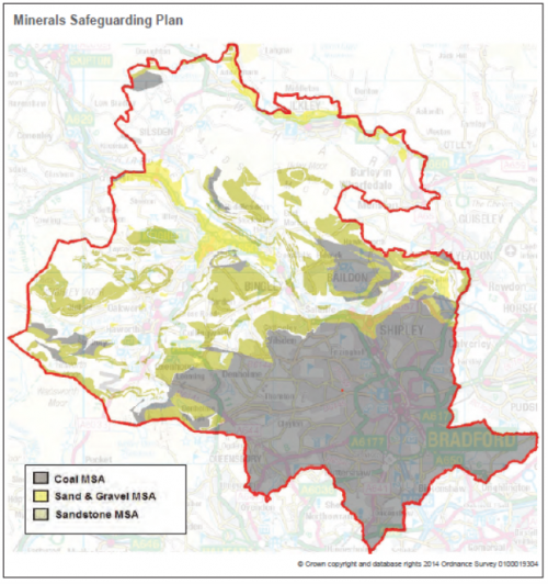
APPENDIX 4: MINERALS SAFEGUARDING PLAN
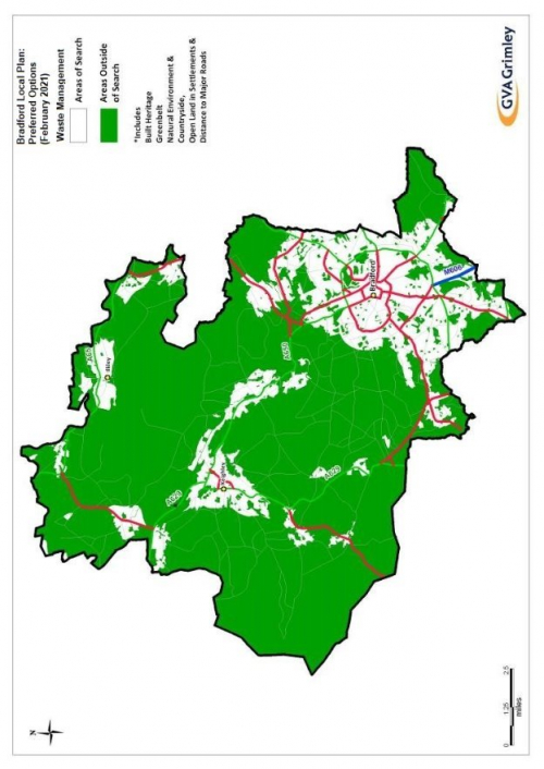
APPENDIX 5: WASTE MANAGEMENT AREAS OF SEARCH
Appendix 6
Accessibility Standards
The following tables provide guidance for the locational policies TR1, TR3, TR4 & TR5 for the development of employment and social infrastructure uses as well as proposed housing sites.
Accessibility is the potential for people to reach certain places within a given time.
Where a site does not conform to the accessibility standards at the time of submission it is expected that mitigating measures should be included within the development proposals that would come into effect at the time of initial occupation of the site. These measures may take a number of forms including (but not exclusively), extensions to existing bus services, re-routing of existing bus services, increased frequency of bus services, provision of new bus services, provision of community transport services, community car clubs, community car sharing schemes, improvements to the walking and cycling network (to make distances to public transport shorter), contributions to other public transport provision (including rail) and other innovative accessibility improvements.
Appendix 6 - Accessibility Standards
Table 1: Accessibility Standards for Employment and Social Infrastructure Uses
|
Employment |
Primary Health / |
Secondary Health / |
Leisure, Retail |
|
|
Education |
Education |
and Other |
||
|
Sites located |
400m of a bus stop |
400m of a bus stop |
400m of a bus stop |
400m of a bus stop |
|
in Bradford |
(or 800m of a rail |
(or 800m of a rail |
(or 800m of a rail |
(or 800m of a rail |
|
Urban Area or |
station) offering a |
station) offering a |
station) offering a |
station) offering a |
|
extensions to |
service at least 4 |
service at least 4 |
service at least 4 |
service at least 4 |
|
the urban area |
times per hour to a |
times per hour to a |
times per hour to a |
times per hour to a |
|
(Regional Cities, |
town or city centre* |
town or city centre* |
town or city centre* |
town or city centre* |
|
Principal Towns |
||||
|
& Local Growth |
||||
|
Centres) should |
||||
|
normally be |
||||
|
within; |
||||
|
Sites located in |
400m of a bus stop |
400m of a bus stop |
400m of a bus stop |
400m of a bus stop |
|
Local Service |
(or 800m of a rail |
(or 800m of a rail |
(or 800m of a rail |
(or 800m of a rail |
|
Centres should |
station) offering a |
station) offering a |
station) offering a |
station) offering a |
|
normally be |
service at least 2 |
service at least 2 |
service at least 2 |
service at least 2 |
|
within; |
times per hour to a |
times per hour to a |
times per hour to a |
times per hour to a |
|
town or city centre* |
town or city centre* |
town or city centre* |
town or city centre* |
Table 2: Accessibility Standards for Housing and Mixed Use Developments (that include residential)
|
To Primary Health / |
To Town |
|||
|
To Local Services |
To Employment |
Centres / City |
||
|
Education |
||||
|
Centres |
||||
|
Sites located |
400m of a bus stop |
400m of a bus stop |
400m of a bus stop |
400m of a bus |
|
in Bradford |
(or 800m of a rail |
(or 800m of a rail |
(or 800m of a rail |
stop (or 800m |
|
Urban Area or |
station) offering a |
station) offering a |
station) offering a |
of a rail station) |
|
extensions to |
service at least 4 |
service at least 4 |
service at least 4 |
offering a service |
|
the urban area |
times per hour to a |
times per hour to a |
times per hour to a |
at least 4 times |
|
(Regional Cities, |
town or city centre* |
town or city centre* |
town or city centre* |
per hour to a |
|
Principal Towns |
town or city |
|||
|
& Local Growth |
Or 10mins walk time |
Or 20mins walk time |
centre* |
|
|
Centres) should |
(800m) |
(1600m) |
||
|
normally be |
||||
|
within; |
||||
|
Sites located in |
400m of a bus stop |
400m of a bus stop |
400m of a bus stop |
400m of a bus |
|
Local Service |
(or 800m of a rail |
(or 800m of a rail |
(or 800m of a rail |
stop (or 800m |
|
Centres should |
station) offering a |
station) offering a |
station) offering a |
of a rail station) |
|
normally be |
service at least 2 |
service at least 2 |
service at least 2 |
offering a service |
|
within; |
times per hour to a |
times per hour to a |
times per hour to a |
at least 2 times |
|
town or city centre* |
town or city centre* |
town or city centre* |
per hour to a |
|
|
town or city |
||||
|
Or 10mins walk time |
Or 20mins walk time |
centre* |
||
|
(800m) |
(1600m) |
*Town or City Centres defined as public transport interchange point, including rail stations, in one of the following centres; Bradford, Leeds, Halifax, Ilkley, Keighley, Bingley or Shipley.
Permeability Standards
Permeability is a measurement of how publicly accessible space allows access through other space and structures. Development should be designed to enable permeability for pedestrians that is greater at all times than for motor vehicles. This can be measured through an area-weighted average perimeter measure (AWAP), where:
- The proposed development layout is divided into blocks, delineated by the centreline of the spaces accessible to the public (such as roads or footpaths), expanding to the roads/footpaths to which the development connects, but excluding dead ends
- The perimeter (in metres) and area (in hectares) of each block is calculated
- A weighted average of the perimeters is taken, where each perimeter is weighted by the area of the respective block.
- New development should aim for permeability which is greater (a lower AWAP score) or the same as existing development nearby. City and town centre sites should aim for a score of 300 or lower, and sites should not exceed 600 unless it would prejudice development (such as in the case of buildings with a very large footprint)
- Development should not lead to permeability worsening on a given site (such as in the case of pre-existing rights of way).
Appendix 7 Parking Standards
The parking standards below are based on the standards set out in the former PPG13 (February 2019) and Regional Planning Guidance RPG12 (Oct 2001), along with alignment with neighbouring authorities standards.
The standards are designed to be indicative and will enable the Council to regulate the provision of parking on developments, whilst being mindful of the need to balance parking with the impact it can have on the environment such as on street parking if left unmanaged.
As per the guidelines set out in the National Planning Policy Framework the level of parking provision will be determined by:
- the accessibility of the development (as assessed against the Accessibility Standards);
- the type, mix and use of development;
- the availability of and opportunities for public transport (as assessed against the Accessibility Standards);
- local car ownership levels; and
- an overall need to reduce the use of high-emission vehicles.
Wherever possible, the Council will seek to minimise the number of spaces provided on site particularly in highly accessible locations such as the City Centre and Principal Town Centres.
The Council is committed to promoting electric vehicles. New developments must allow for electrical supply infrastructure for up to 34% of long-stay parking spaces to be converted to electric charging, if this is not undertaken upon development occupation.
Parking standards are divided into 4 categories in a hierarchy as shown in Table 1. Higher categories must be considered for suitability for the proposed development before a lower category can be considered.
Table 1 – Development Sustainability Hierarchy
|
Location |
Parking standard as proportion of 'Unsustainable' maximum |
Type of parking provision |
Reduction in vehicle trips compared with local prevailing rate |
|
|
Zero-Car (Z) |
City and town centres or where traffic is restricted |
0% |
Off-site |
100% |
|
Traffic-Free (T) |
City and town centres, or locations meeting the accessibility standards |
0-30% |
preferably fulfilled off-site, active and public transport always more convenient |
Up to 80% |
|
Car-Light (C) |
Outside city and town centres, locations meeting the accessibility standards |
30-70%, spaces beyond 50% may be considered 'contingent' |
designed to be less convenient than active and public transport, may be fulfilled off-site |
Up to 50% |
|
Unsustainable (U) |
Remaining |
70-100%, spaces beyond 50% may be considered 'contingent' |
On-site |
Up to 30% |
In Traffic-Free and Car-Light developments, the Council encourages off-site parking provision to be explored first before accepting on-site provision. Off-site parking in city and town centres should be provided as part of a parking structure, and this approach should be considered in all types of development. In Unsustainable and Car-Light sites, parking spaces provided beyond 50% of the 'Unsustainable' maximum may be considered contingent', requiring applicants to later neutralise spaces or convert them to non-parking uses, based on observed use.
Table 2 – Vehicle Parking Standards
|
Type and Size of Development |
Parking Standards (maximum) |
||||
|
Zero-Car |
Traffic-Free |
Car-Light |
Unsustainable |
||
|
A1 |
Food Retail (under 500sqm) |
Yes, 0 spaces |
1 space per 120sqm |
1 space per 50sqm |
1 space per 35sqm |
|
A1 |
Food Retail (500-999sqm) |
Yes, 0 spaces |
1 space per 120sqm |
1 space per 50sqm |
1 space per 20sqm |
|
A1 |
Food Retail (above 1000sqm) |
Yes, 0 spaces |
1 space per 120sqm |
1 space per 50sqm |
1 space per 14sqm |
|
A1 |
Non-Food Retail (under 500sqm) |
Yes, 0 spaces |
Minimum operational requirement |
1 space per 36sqm |
1 space per 25sqm |
|
A1 |
Non-Food Retail (500-999sqm) |
Yes, 0 spaces |
Minimum operational requirement |
1 space per 36sqm |
1 space per 25sqm |
|
A1 |
Non-Food Retail (above 1000sqm) |
Yes, 0 spaces |
1 space per 83sqm |
1 space per 36sqm |
1 space per 25sqm |
|
A2 |
Offices |
Yes, 0 spaces |
Minimum operational requirement |
1 space per 15sqm |
1 space per 10sqm |
|
A3 |
Food and Drink |
Yes, 0 spaces |
Minimum operational requirement (presumption against) |
1 space per 10sqm |
1 space per 5sqm |
|
A4 |
Public Houses/Wine Bars |
Yes, 0 spaces |
Minimum operational requirement (presumption against) |
1 space per 10sqm |
1 space per 5sqm |
|
A5 |
Hot Food Takeaway |
Yes, 0 spaces |
Minimum operational requirement (presumption against) |
1 space per 10sqm |
1 space per 5sqm |
|
B1 |
Business |
Yes, 0 spaces |
Minimum operational requirement |
1 space per 45 sqm |
1 space per 30sqm |
|
B2 |
Industry (above 2500 sqm) |
Yes, 0 spaces |
Minimum operational requirement |
1 space per 75 sqm |
1 space per 50sqm |
|
B8 |
Storage and Distribution |
N/A |
Minimum operational requirement |
1 space per 250sqm |
1 space per 250sqm |
|
C1 |
Hotels and Guest Houses |
Yes, 0 spaces |
Minimum operational requirement (presumption against) |
1 space per 2 bedrooms |
1 space per bedroom |
|
C2 |
Hospitals (above 2500sqm) |
N/A |
1 space per 12 staff + 1 space per 12 daily visitors |
1 space per 6 staff + 1 space per 6 daily visitors |
1 space per 4 staff + 1 space per 4 daily visitors |
|
C2 |
Nursing Homes |
N/A |
1 space per 8 residents + 1 space per 7 staff |
1 space per 7 residents + 1 space per 3 staff |
1 space per 5 residents + 1 space per 2 staff |
|
C3 |
Student Halls |
Yes, 0 spaces |
Minimum operational requirement (presumption against) |
1 space per 8 students |
1 space per 5 students |
|
C3 |
Dwellings |
Yes, 0 spaces |
Average of 0.4 spaces per unit |
Average of 0.8 spaces per unit |
Average of 1.2 spaces per unit |
|
C3 |
Sheltered Housing |
Yes, 0 spaces |
1 space per 12 staff + 1 space per 12 daily visitors |
1 space per 6 staff + 1 space per 6 daily visitors |
1 space per 4 units + 1 space per 4 units for visitors and staff |
|
C3 |
Hostels |
Yes, 0 spaces |
Minimum operational requirement (presumption against) |
1 space per 6 staff + 1 space per 6 residents |
1 space per 4 staff + 1 space per 4 residents |
|
C4 |
Houses Multiple Occupancy |
Yes, 0 spaces |
0 spaces |
1 space per 3 bedrooms |
1 space per 2 bedrooms |
|
D1 |
Non-residential Health Centres, Surgeries |
N/A |
1 space per consulting room + 1 space per 10 staff |
2 spaces per consulting room + 1 space per 5 staff |
3 spaces per consulting room + 1 space per 3 staff |
|
D1 |
Day nurseries & crèches |
Yes, 0 spaces |
1 space per 20 children |
1 space per 9 children |
1 space per 6 children |
|
D1 |
Places of Worship |
Yes, 0 spaces |
Minimum operational requirement |
1 space per 36sqm |
1 space per 25sqm |
|
D1 |
Libraries |
Yes, 0 spaces |
Minimum operational requirement |
1 space per 36sqm |
1 space per 25sqm |
|
D1 |
Museums |
Yes, 0 spaces |
Minimum operational requirement |
1 space per 90sqm |
1 space per 60sqm |
|
D1 |
Primary Schools |
N/A |
1 space per 4 staff + 3 spaces for visitors |
1 space per 3 staff + 4 spaces for visitors |
1 space per 2 staff + 5 spaces for visitors |
|
D1 |
Secondary Schools |
N/A |
1 space per 4 staff + 6 spaces for visitors |
1 space per 3 staff + 8 spaces for visitors |
1 space per 2 staff + 10 spaces for visitors |
|
D1 |
Higher and Further Education (above 2500 sqm) |
N/A |
1 space per 4 staff + 8 spaces for visitors |
1 space per 3 staff + 10 spaces for visitors |
1 space per 2 staff + 15 spaces for visitors |
|
D2 |
Assembly and Leisure (above 1000 sqm) |
Yes, 0 spaces |
Minimum operational requirement |
1 space per 35sqm |
1 space per 22sqm |
|
D2 |
Cinemas, Conference and Concert ( above 1000 sqm) |
Yes, 0 spaces |
Minimum operational requirement |
1 space per 15 seats |
1 space per 5 seats |
|
D2 |
Stadia |
N/A |
N/A |
N/A |
1 space per 15 seats + coach lay-by parking |
|
D2 |
Leisure Sports and Leisure activities, Swimming pools, Tennis/Squash/Bowling |
Yes, 0 spaces |
Minimum operational requirement |
Minimum operational requirement |
1 space per 2 players/staff 1 space per 5 fixed seats, 1 space per 10sqm pool area, 4 space per court/lane |
|
D2 |
Riding Stables/Equestrian Centres |
N/A |
N/A |
N/A |
1 space per 2 horses on the yard + 1 horsebox space per 150sqm |
|
D2 |
Other Uses |
Yes, 0 spaces |
1 space per 100sqm |
1 space per 50sqm |
1 space per 25sqm |
|
SG |
Auction Rooms and Garage Forecourts |
N/A |
N/A |
N/A |
1 space per 2sqm standing area |
|
SG |
Workshops |
N/A |
N/A |
N/A |
1 space per 2 staff, 3 spaces per service bay |
|
SG |
Private Hire/Hackney Carriage office |
N/A |
N/A |
N/A |
Min 5 spaces or 1 space for every 4 cars operating from |
|
SG |
Filling Stations |
N/A |
N/A |
N/A |
1 space per 2 staff |
Parking Standards
In addition to the parking provision set out in the table above it is expected that developments should provide adequate parking for disabled motorists at the levels set out in Table 2 below:
Table 3 – Disabled Parking Standards
|
Type of Development |
Level of Provision |
|
Employment Site |
Up to 200 parking spaces 5% of capacity should be |
|
reserved for disabled parking (minimum 2 spaces) |
|
|
Over 200 spaces 2% of capacity + 6 spaces should be |
|
|
reserved for disabled parking |
|
|
Public, shopping and Leisure Facilities |
Up to 200 spaces 6% of capacity should be reserved for |
|
disabled parking (minimum 3 spaces) |
|
|
Over 200 spaces 4% of capacity + 4 spaces should be |
|
|
reserved for disabled parking |
In line with policies TR1 and TR3 developments should provide adequate secure parking provision for cyclists and motorcyclists as per the Table 3 below. Refer also to LTN 1/20, Chapter 11 for further guidance on cycle parking standards and what constitutes long and short stay parking.
All categories must provide parking for adapted cycles for disabled people, to 5% of total cycle parking capacity for each of short and long stay parking, co-located with disabled vehicle parking, rounded up to the nearest whole number.
Table 4 - Cycle Parking Standards
|
Type, Size and Location of Development |
Cycle and Motorcycle Parking Standards |
|
|
A1 |
Retail Food / Non Food |
Long stay – 1 secure stand per 100sqm |
|
Short stay – 1 stand per 100sqm |
||
|
A2 |
Financial & Professional services |
Short stay – 1 stand per 100sqm, Long stay - 1 secure stand per 300sqm |
|
A3 Food & Drink |
Long stay - 1 secure stand per 100sqm |
|
|
Short Stay – 1 stand per 40sqm (max 10) |
||
|
A4 Public Houses & Wine Bars |
Each case to be considered on merit |
|
|
A5 Hot Food Takeaway |
Each case to be considered on merit |
|
|
B1 |
Business Offices |
Long stay – 1 secure stand per 150sqm |
|
Short Stay – 1 stand per 500sqm |
||
|
B1 |
Business Light Industry |
Long stay – 1 secure stand per 150sqm |
|
Short Stay – 1 stand per 500sqm |
||
|
B2 |
General Industry |
Long stay – 1 secure stand per 350sqm |
|
Short stay – 1 stand per 500sqm |
||
|
B8 |
Warehousing / Storage & Distribution |
Long stay – 1 secure stand per 500sqm |
|
Short stay – 1 stand per 1000sqm |
||
|
C1 |
Hotels, Boarding & Guest Houses |
Long Stay – 1 secure stand per 10 employees |
|
Short Stay – 1 stand per 10 beds |
||
|
C2 |
Hospital |
Long stay – 1 secure stand per 6 staff |
|
Short Stay – 1 stand per 2 beds |
||
|
C2 Nursing Homes |
Long stay – 1 secure stand per 6 staff |
|
|
Short stay 1 stand per 2 beds |
||
|
C3 |
Dwellings Flats |
Long stay – 1 secure stand per bedroom |
|
Short stay – 1 stand per unit |
||
|
C3 Dwellings Houses/Bungalows |
Long stay – 1 secure stand per bedroom |
|
|
Short stay – 1 stand per unit |
||
|
C3 Student Accommodation |
Long stay – 1 secure stand per bedroom |
|
|
Short stay – 1 stand per unit |
||
|
C3 |
Retired / Sheltered Accommodation |
Long stay – 1 secure stand per unit |
|
Short stay – 1 stand per unit |
||
|
C4 |
Houses Multiple Occupation |
Long Stay – 1 secure stand per bedroom |
|
D1 |
Health Centres / surgeries |
Long stay – 1 secure stand per 2 consulting rooms |
|
Short stay – 1 stand per consulting room |
||
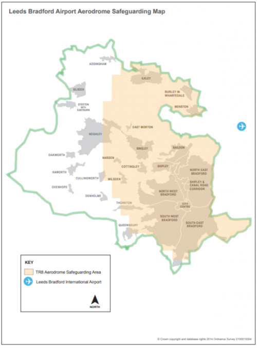
APPENDIX 8: LEEDS BRADFORD AIRPORT AERODROME SAFEGUARDING MAP
Appendix 9 | Bradford's Nature Conservation Designations (Policy EN2)
|
Reference |
Site Name |
|
Special Protection Areas (SPA) |
|
|
SPA001 |
South Pennine Moors Phase II |
|
Special Area of Conservation (SAC) |
|
|
SAC001 |
South Pennine Moors |
|
Sites of Scientific Interest (SSSI) |
|
|
SSSI001 |
Bingley South Bog |
|
SSSI002 |
Trench Meadows |
|
SSSI003 |
Yeadon Brickworks & Railway Cutting |
|
SSSI004 |
South Pennine Moors |
|
Local Nature Reserves (LNR) |
|
|
LNR001 |
Railway Terrace |
|
LNR002 |
Sun Lane, Burley in Wharfedale |
|
LNR003 |
Tong Moor |
|
LNR004 |
Ben Rhydding Gravel Pits |
|
Local Wildlife Sites (LWS) |
|
|
LWS001 |
How Beck Wood Riddlesden |
|
LWS002 |
Shipley Station |
|
LWS003 |
Carperley Beck |
|
LWS004 |
Birks Wood |
|
LWS005 |
Black Carr Wood |
|
LWS006 |
Hirst Wood |
|
LWS007 |
Hainworth Wood |
|
LWS008 |
Harden Moor and Deepcliffe Wood |
|
LWS009 |
Denholme Gate |
|
LWS010 |
Odsal Wood |
|
LWS011 |
Park Wood |
|
LWS012 |
St Leonard's Farm |
|
LWS013 |
St Ive's Estate |
|
LWS014 |
Bierley Wood |
|
LWS015 |
Crabtree Ghyll |
|
LWS016 |
Low Wood |
|
LWS017 |
Fairbank Wood |
|
LWS018 |
Great Wood - West Wood |
|
LWS019 |
Hainsworth Hedges |
|
LWS020 |
Lumbgill Wood |
|
LWS021 |
Low Mill, Addingham |
|
LWS022 |
Owlhill Wood |
|
LWS023 |
Panorama Wood |
|
LWS024 |
Nun Wood |
|
LWS025 |
Baildon Moor |
|
LWS026 |
Black Moor |
|
LWS027 |
Brow Moor |
|
LWS028 |
Brackenhill Ghyll |
|
LWS029 |
Brackenhill Grassland |
|
LWS030 |
Buck Park Quarry |
|
LWS031 |
Bull Greave Beck |
|
LWS032 |
Burley Disused Railway |
|
LWS033 |
Gillgrange Clough |
|
LWS034 |
Great Gill |
|
LWS035 |
Jacob's Wood/ Holden Beck |
|
LWS036 |
Silverdale, Denholme |
|
LWS037 |
St Paul's Wood |
|
LWS038 |
Swartha Wood |
|
LWS039 |
Briery Wood and Heber's Ghyll |
|
LWS040 |
Buck Wood West |
|
LWS041 |
Buck Wood East |
|
LWS042 |
Burley Bypass Verges |
|
LWS043 |
Chellow Dean Woods and Reservoir |
|
LWS044 |
Elam Wood |
|
LWS045 |
Fagley Beck |
|
LWS046 |
Graincliffe & Compensation Reservoir |
|
LWS047 |
Bingley North Bog |
|
LWS048 |
Stockbridge Nature Reserve |
|
LWS049 |
Cottingley Woods - Black Hills |
|
LWS050 |
Gilstead Moor Edge and Prince of Wales Park |
|
LWS051 |
Dowdy Wood |
|
LWS052 |
Ewe Hills |
|
LWS053 |
Hawkcliffe Wood, Steeton |
|
LWS054 |
Hawkstone Wood, Esholt |
|
LWS055 |
Heaton Woods, Northcliffe Woods and Old Spring Woo |
|
LWS056 |
Hewenden Wood, Cullingworth |
|
LWS057 |
Hollin Plantation |
|
LWS058 |
Horton Bank Country Park |
|
LWS059 |
Ives Plantation, Oxenhope |
|
LWS060 |
Judy Woods |
|
LWS061 |
Milking Hole Beck and Hewenden Reservoir |
|
LWS062 |
Nan Scar Clough, Oxenhope |
|
LWS063 |
Owler Park and Spring Wood, Ilkley |
|
LWS064 |
Penistone Hill Country Park |
|
LWS065 |
Shipley - Thackley Disused Railway |
|
LWS066 |
Rye Loaf Hill, Cottingley |
|
LWS067 |
Silsden Reservoir Woodland |
|
LWS068 |
Spring and Jerrison Woods |
|
LWS069 |
Spring Crag and Alder Carr Wood |
|
LWS070 |
Sun Hill Clough, Oxenthorpe |
|
LWS071 |
Terrace Ghyll - Ilkley |
|
LWS072 |
Thackley Wood |
|
LWS073 |
Transfield Wood |
|
LWS074 |
Whins Wood |
|
LWS075 |
Boar's Well Urban Willdlife Reserve |
|
LWS076 |
Railway Terrace and Raw Nook |
|
LWS077 |
Sun Lane, Burley in Wharfedale |
|
LWS078 |
Steeton Reservoir |
|
LWS079 |
Marley Bog |
|
LWS080 |
Brown Bank Marsh |
|
LWS081 |
White Hill |
|
LWS082 |
Newsholme Dean |
|
LWS083 |
Shibden Head |
|
LWS084 |
Harden Beck |
|
LWS085 |
Middleton Woods |
|
LWS086 |
Miles Rough, Cottingley |
|
LWS087 |
Toad Holes Beck, Oakenshaw |
|
LWS088 |
Airedale Spring Mill Pond, Haworth |
|
LWS089 |
Baden Street, Haworth |
|
LWS090 |
Beechcliffe Ings |
|
LWS091 |
Beechcliffe Ox-bow |
|
LWS092 |
Ben Rhydding Gravel Pits |
|
LWS093 |
Brow Moor with Sugden End |
|
LWS094 |
Currer Wood, Steeton |
|
LWS095 |
Grassland near Steg Holes |
|
LWS096 |
Hazel Beck, Cottingley |
|
LWS097 |
Holme House Wood and Grasslands, Keighley |
|
LWS098 |
Millman Bridge Ox-bow |
|
LWS099 |
Noon Nick |
|
LWS100 |
Park Wood, Tong |
|
LWS101 |
Shipley Glen |
|
LWS102 |
Steg Holes |
|
LWS103 |
West of Shipley High Moor |
|
LWS104 |
Far Bank, Addingham |
|
LWS105 |
Tong Park with Hawksworth Spring Wood |
|
LWS106 |
Pitty Beck, Thornton |
|
LWS107 |
Baildon Bank |
|
LWS108 |
Nab Wood, Shipley |
|
Local Geological Sites (LGS) |
|
|
LGS001 |
Addingham Edge Millstone Quarry |
|
LGS002 |
Baildon Bank and Baildon Green Quarries |
|
LGS003 |
Baildon Moor |
|
LGS004 |
Cow and Calf Rocks, Ilkley |
|
LGS005 |
Dimples Quarry, Haworth |
|
LGS006 |
Doubler Stones, Addingham Moorside |
|
LGS007 |
Eldwick Crag and Quarry |
|
LGS008 |
Goitstock Waterfall, Cullingworth |
|
LGS009 |
Horton Bank Country Park, Bradford |
|
LGS010 |
Lanshaw Delves, Ilkley |
|
LGS011 |
Noon Nick, Shipley |
|
LGS012 |
Ponden Clough, Haworth |
|
LGS013 |
Royds Hall Beck, Wyke |
|
LGS014 |
Shipley Glen |
|
LGS015 |
Throstle Nest, Silsden |
|
LGS016 |
Wrose Hill, Shipley |
APPENDIX 10: OPERATIONAL/PERMITTED WASTE MANAGEMENT SITES IN BRADFORD DISTRICT
The table below sets outs details of operational and permitted waste management sites within Bradford District. It is based on sites information from the Bradford Waste Model and the Active Sites lists from the Environment Agency's Waste Data Interrogator 2018 and 2019. It should be noted that this list will be updated for subsequent stages of the plan, should further information come forward.
|
Site Category |
Facility Type |
Facility Name & Address |
|
Combustion |
Gas Engine |
Esholt Waste Water Treatment Works, Ainsbury Avenue, Bradford |
|
Recovery |
Deposit of waste to land as a recovery |
The Shay, Brighouse & Denholme Road, Thornton |
|
Midgeham Cliff End Quarry, Ryecroft Road, Hardena |
||
|
Landfill |
Inert Landfill |
The Far Shay, Brighouse & Denholme Road, Thornton |
|
Hallas Rough Quarry, Black Moor, Halifax Road, Cullingworth |
||
|
MRS |
Car Breaker |
Yard at Simmonites 755 Thornton Road, Thornton, Bradford |
|
Listerhills Salvage, Unit 1, Handel Street, Listerhills, Bradford |
||
|
Yorkshire Van Breakers Ltd, Hutson Street, Marshfields, Bradford |
||
|
Hall Lane Car Spares, Hall Lane, East Bierley, Bradford |
||
|
Bowling Autos, Rutland Street, Bradford |
||
|
Triple XXX Car Spares, Victoria House, Garnett Street, Bradford |
||
|
Quarry Auto Spares, Carr House Lane, Wyke, Bradford |
||
|
City Salvage, 115 Beckside, Lidgett Green, Bradford |
||
|
Tay Motors, 115 Beckside, Lidgett Green, Bradford |
||
|
Bradford Autospares & Salvage, Old Co-op Dairy, Rutland Street, Bradford |
||
|
Knowles Mill, Unit 17a, Knowles Street, Bradford |
||
|
Springfield Autos, Arthur Street, Idle, Bradford |
||
|
Universal Car Spares Ltd, Mill Lane, Bradford |
||
|
Vrww's, Grosvenor Works, Grosvenor Road, Bradford |
||
|
Metal Recycling |
Newgate Works, Bowling Back Lane, Bradford |
|
|
Dick Lane Metals, Dick Lane, Tyersal, Bradford |
||
|
Newgate Works, Back Muff Street, Bowling Back Lane, Bradford |
||
|
Hector Moore Ltd, Deal Street, Worth Village, Keighley |
||
|
Ridgenorth Ltd, Lawkholme Lane, Keighley |
||
|
EMR, Old Railway Goods Yard, Planetrees Road, Bradford |
||
|
Land at Foster Cliffe Farm, Low Lane, Silsden |
||
|
Crossley Evans Ltd, Station Sidings, Otley Road, Shipley |
||
|
Tom Dawson Metals, Thornton Road |
||
|
Vehicle Depollution Facility |
Laisterdyke Vehicle Dismantlers, Laisterdyke Road, Laisterdyke, Bradford |
|
|
Manningham Car Breakers, Clifton Mill, Clifton Street, Manningham, Bradford |
||
|
Shipley Auto Spares, Leeds Road, Shipley |
||
|
Triple XXX Motorbike Breakers, Dispatch Depot, Lyndale House, Fitzwilliam Street, Bradford |
||
|
Storage |
Temporary Storage Installation |
Progress Works, Hall Lane, Bradford |
|
Transfer |
Civic Amenity Site |
Bradford Household Waste Site, Bradford Bulk Loading Station, Bowling Back Lane, Bradford |
|
Dowley Gap Recycling Centre & Household Waste Site, Wagon Lane, Bingley |
||
|
Ford Hill Household Waste Site, Hill End Lane, Ford Hill, Queensbury |
||
|
Keighley Household Waste Site, Royd Ings Avenue, Keighley |
||
|
Sugden End Household Waste Site, Halifax Road, Keighley |
||
|
Dealburn Road Household Waste Recycling Centre, Dealburn Road, Low Moor, Bradford |
||
|
Midland Road Household Waste Recycling Centre, Midland Road, Manningham, Bradford |
||
|
Golden Butts Household Waste Recycling Centre, Golden Butts Road, Ilkley |
||
|
Hazardous Waste Transfer |
Highspeed Group Ltd, Unit 1, Newbridge Industrial Estate, Pitt Street, Keighley |
|
|
Bradford Bulk Transfer Loading Station, Bowling Back Lane, Bradford |
||
|
Spartan Road Site, South Bradford Trading Estate, Spartan Road, Low Moor, Bradford |
||
|
Manor Coating Systems Ltd, Otley Road, Charlestown, Shipley |
||
|
Non-Hazardous Waste Transfer/Treatment |
Premises at Whitewell Street, Victoria Works, Barnard Road, Bradford |
|
|
Hill Top Works, Walsh Lane, Bingley |
||
|
Peel Park Depot, Step Yard, Bolton Road, Bradford |
||
|
Harris Street Depot, Cleansing Depot, Harris Street, Bradford |
||
|
Keighley TLS, Keighley Bulk Transfer Station, Royd Ings Avenue, Keighley |
||
|
Envirowaste Services Ltd, Queens Road, Bradford |
||
|
Land off Bradley Road, Bradley Road, Silsden |
||
|
Premises off Ripley Road, Ripley Road, West Bowling, Bradford |
||
|
Hammerton Street, Bradford |
||
|
Alma Works, Fred's Place, Bradford |
||
|
Laisterdyke Transfer Station, Peace Street, Laisterdyke, Bradford |
||
|
Progress Works, Hall Lane, Bradford |
||
|
Treatment |
Biological Treatment |
Esholt Waste Water Treatment Works, Ainsbury Avenue, Bradford |
|
Chemical Treatment |
Thornton Processing Ltd, Caledonia Works, Fullerton Street, Bradford |
|
|
Inert Waste Transfer/Treatment |
Bradford Recycling, Beckside Works, Old Cornmill Lane, Bradford |
|
|
Material Recycling Facility |
Euroway, Unit 1, Wharfedale Road, Euroway Industrial Estate, Bradford |
|
|
Canal Road Materials Recycling Facility |
||
|
Non-Hazardous Waste Transfer/Treatment |
Associated Waste Management Ltd, Neville Road, Bowling, Bradford |
|
|
Old Crown Dyeworks, Birkshall Road, Bradford |
||
|
Unit 15, Iron Works Park, Bowling Back Lane, Bradford |
||
|
Physical Chemical Treatment |
BASF, Dealburn Road, Low Moor, Bradford |
|
|
Bow Beck Clinical Waste Treatment Facility, Bow Beck, Bowling Back Lane, Bradford |
||
|
Physical Treatment |
Midgeham Cliff End Quarry, Ryecroft Road, Harden |
|
|
Octane House, Peace Street, Bradford |
||
|
WEEE Treatment Facility |
Newgate Works, Bowling Back Lane, Bradford |
|
|
C.J. Metal Recycling, The Yard, Heber Street, Keighley |
||
|
Juz Electronic Ltd, Carter Gate Works, Thornbury Road, Bradford |
a This is onlya temporary planning permission. Restoration should be completed in the mid/late 2020s.
Appendix 11 – Open Space Standards
|
Typology |
Bradford Open Space Quantity Standard (ha/1,000 population) |
Bradford Open Space Accessibility Standards Distance from residential property to open space site (metres) |
|
Allotments |
0.20 |
2.1 800 |
|
Amenity greenspace |
0.50 |
2.2 480 |
|
Cemeteries |
0.25 |
2.3 1,200 |
|
Civic spaces |
0.01 |
2.4 1,600 |
|
Green and Blue corridors |
0.20 |
2.5 720 |
|
Natural and semi-natural greenspace |
1.00 |
2.6 720 |
|
Open land in settlements |
0.45 |
2.7 800 |
|
Outdoor sports facilities |
1.80 |
2.8 1,200 |
|
Parks and gardens |
0.90 |
2.9 800 |
|
Provision for children and young people* |
(0.4 sites per 1,000 pop) |
|
|
2.10 Doorstep Playable Spaces (Similar to LAP (Local Area Play)) |
2.11 100 |
|
|
2.12 Local and Neighbourhood Playable Spaces 2.13 (Similar to LEAP (Locally Equipped Area for Play)) |
2.14 400 |
|
|
2.15 Destination Play 2.16 (Similar to NEAP (Neighbourhood Equipped Area for Play)) |
2.17 1000 |
|
|
2.18 BMX /Skate Parks |
2.19 700 |
*The resulting standard for Provision for Children and Young People is expressed as the number of sites per 1,000 of the population rather than the area.
Appendix 12 – Planning Commitments
|
Council Ref |
Address |
Ward |
Sub Area |
Total |
Units completed at 31/03/2020 |
Units carried forward into the Local Plan |
|
CC/003 |
Hamm Strasse |
City |
Top of Town/City Village |
166 |
0 |
166 |
|
CC/012 |
National House, Sunbridge Road |
City |
Goitside |
64 |
0 |
64 |
|
CC/023 |
Conditioning House |
City |
Forster Square, Little Germany & Cathedral Quarter |
133 |
0 |
133 |
|
CC/067B |
5 Cheapside |
City |
Top of Town/City Village |
5 |
0 |
5 |
|
CC/067C |
6 Picadillly |
City |
Top of Town/City Village |
8 |
0 |
8 |
|
CC/067D |
8-10 Picadilly |
City |
Top of Town/City Village |
34 |
0 |
34 |
|
CC/067E |
12 Picadilly |
City |
Top of Town/City Village |
13 |
0 |
13 |
|
CC/068B |
34-36 Canal Road |
City |
Forster Square, Little Germany & Cathedral Quarter |
33 |
0 |
33 |
|
CC/068C |
36 Canal Road |
City |
Forster Square, Little Germany & Cathedral Quarter |
45 |
0 |
45 |
|
CC/068E |
24-26 Canal Rd |
City |
Forster Square, Little Germany & Cathedral Quarter |
30 |
0 |
30 |
|
CC/077 |
Olicana House |
City |
Forster Square, Little Germany & Cathedral Quarter |
158 |
49 |
109 |
|
CC/086 |
43 Darley Street |
City |
Top of Town/City Village |
9 |
0 |
9 |
|
CC/089 |
Arndale House |
City |
Forster Square, Little Germany & Cathedral Quarter |
126 |
0 |
126 |
|
CC/093 |
153 Sunbridge Rd |
City |
Goitside |
56 |
0 |
56 |
|
CC/098 |
Church Bank |
City |
Forster Square, Little Germany & Cathedral Quarter |
110 |
32 |
78 |
|
CC/101 |
Well Street |
City |
Forster Square, Little Germany & Cathedral Quarter |
59 |
0 |
59 |
|
CC/102 |
38-42 Peckover street |
City |
Forster Square, Little Germany & Cathedral Quarter |
6 |
3 |
3 |
|
CC/103 |
46 Peckover Street |
City |
Forster Square, Little Germany & Cathedral Quarter |
43 |
41 |
2 |
|
CC/106 |
Upper Millergate |
City |
Top of Town/City Village |
32 |
0 |
32 |
|
CC/107 |
Wardley House |
City |
The Central Civic Business & Leisure District |
16 |
4 |
12 |
|
CC/108 |
Hollings Mill |
City |
Goitside |
59 |
0 |
59 |
|
CC/110 |
George Street |
City |
The Central Civic Business & Leisure District |
28 |
0 |
28 |
|
CC/111 |
17a Westgate |
City |
Top of Town/City Village |
9 |
0 |
9 |
|
CC/112 |
19 Peckover Street |
City |
Forster Square, Little Germany & Cathedral Quarter |
26 |
0 |
26 |
|
CC/115 |
77-93 Westgate and 2 Baptist Street |
City |
Top of Town/City Village |
41 |
0 |
41 |
|
CC/117 |
200-206 Leeds Road |
Bowling and Barkerend |
The Southern Gateway |
10 |
0 |
10 |
|
CC/118 |
New Augustus and Trust House Filey Street |
Bowling and Barkerend |
The Southern Gateway |
100 |
49 |
51 |
|
Bradford City Centre Total |
1419 |
178 |
1241 |
|||
|
CR/011 |
Olivers Locks, Canal Road |
Bolton and Undercliffe |
n/a |
1000 |
77 |
923 |
|
CR/012 |
Livingstone Road, Bolton Woods |
Windhill and Wrose |
n/a |
59 |
24 |
35 |
|
CR/038 |
Valley Rd |
Heaton |
n/a |
38 |
0 |
38 |
|
CR/049 |
Otley Road |
Shipley |
n/a |
18 |
0 |
18 |
|
CR/051 |
New Victoria Hotel |
Windhill and Wrose |
n/a |
5 |
0 |
5 |
|
Canal Road Corridor Total |
1120 |
101 |
1019 |
|||
|
NE/004 |
Roundwood Avenue, Ravenscliffe |
Eccleshill |
Undercliffe & Eccleshill |
232 |
185 |
47 |
|
NE/006b |
Westfield Lane, Idle |
Idle and Thackley |
Wrose, Thackley & Idle |
26 |
0 |
26 |
|
NE/013b |
Westfield Lane |
Windhill and Wrose |
Wrose, Thackley & Idle |
10 |
0 |
10 |
|
NE/014 |
Fagley Croft |
Eccleshill |
Undercliffe & Eccleshill |
8 |
0 |
8 |
|
NE/015A |
Harrogate Road, Greengates |
Idle and Thackley |
Wrose, Thackley & Idle |
28 |
0 |
28 |
|
NE/024 |
Crimshaw Lane, Bolton Woods |
Windhill and Wrose |
Wrose, Thackley & Idle |
12 |
0 |
12 |
|
NE/025A |
Simpsons Green |
Idle and Thackley |
Wrose, Thackley & Idle |
268 |
170 |
98 |
|
NE/038 |
Moorside Road, Eccleshill |
Eccleshill |
Undercliffe & Eccleshill |
589 |
0 |
589 |
|
NE/039 |
Fagley Road |
Eccleshill |
Undercliffe & Eccleshill |
128 |
0 |
128 |
|
NE/055A |
Harrogate Rd/Carr Bottom Rd |
Idle and Thackley |
Wrose, Thackley & Idle |
105 |
90 |
15 |
|
NE/056 |
Cote Farm Leeds Road, Thackley |
Idle and Thackley |
Wrose, Thackley & Idle |
219 |
0 |
219 |
|
NE/119 |
Ashton Walk |
Idle and Thackley |
Wrose, Thackley & Idle |
60 |
56 |
4 |
|
NE/147 |
Thackley Grange |
Idle and Thackley |
Wrose, Thackley & Idle |
14 |
0 |
14 |
|
NE/148 |
Harrogate Road |
Idle and Thackley |
Wrose, Thackley & Idle |
45 |
43 |
2 |
|
NE/153 |
114 Undercliffe Road |
Bolton and Undercliffe |
Undercliffe & Eccleshill |
7 |
0 |
7 |
|
NE/162 |
Stockhill Road |
Idle and Thackley |
Wrose, Thackley & Idle |
8 |
0 |
8 |
|
NE/170 |
Peel Park Hotel |
Bolton and Undercliffe |
Undercliffe & Eccleshill |
5 |
0 |
5 |
|
NE/172 |
Sycamore Close |
Bowling and Barkerend |
Barkerend |
25 |
0 |
25 |
|
NE/174 |
Cavendish Rd, Idle |
Eccleshill |
Undercliffe & Eccleshill |
29 |
17 |
12 |
|
NE/175 |
Newstead Hall Rd, Eccleshill |
Eccleshill |
Undercliffe & Eccleshill |
6 |
3 |
3 |
|
NE/176 |
1222 Leeds Rd |
Bradford Moor |
Barkerend |
9 |
0 |
9 |
|
NE/178 |
Haigh Hall Rd, Greengates |
Idle and Thackley |
Wrose, Thackley & Idle |
6 |
0 |
6 |
|
NE/179 |
Former Council office, Ravenscliffe Avenue |
Eccleshill |
Undercliffe & Eccleshill |
15 |
0 |
15 |
|
NE/180 |
78 Westfield Lane |
Windhill and Wrose |
Wrose, Thackley & Idle |
5 |
0 |
5 |
|
NE/181 |
Romanby Shaw |
Eccleshill |
Undercliffe & Eccleshill |
47 |
23 |
24 |
|
Bradford North East Total |
1906 |
587 |
1319 |
|||
|
NW/013B |
Newport Road |
Manningham |
Manningham |
9 |
0 |
9 |
|
NW/019 |
West Avenue, Sandy Lane |
Thornton and Allerton |
Allerton |
14 |
0 |
14 |
|
NW/026A |
Ivy Lane, Allerton |
Thornton and Allerton |
Allerton |
104 |
0 |
104 |
|
NW/028 |
Chellow Grange Road, Heaton |
Heaton |
Heaton |
98 |
0 |
98 |
|
NW/036 |
Whitburn Way |
Thornton and Allerton |
Allerton |
23 |
0 |
23 |
|
NW/038 |
Allerton Lane |
Thornton and Allerton |
Allerton |
9 |
0 |
9 |
|
NW/039 |
Allerton Lane/Cote Lane |
Thornton and Allerton |
Allerton |
292 |
142 |
150 |
|
NW/051 |
Ashwell Farm, Heaton |
Heaton |
Heaton |
27 |
0 |
27 |
|
NW/056 |
Allerton Road, Girlington |
Clayton and Fairweather Green |
Allerton |
11 |
5 |
6 |
|
NW/063 |
Pearson Lane |
Toller |
Girlington |
3 |
0 |
3 |
|
NW/067 |
Saffron Drive, Allerton |
Thornton and Allerton |
Allerton |
6 |
0 |
6 |
|
NW/074 |
Hill Top Lane, Allerton |
Thornton and Allerton |
Allerton |
5 |
0 |
5 |
|
NW/076 |
Fairmount, North Park Drive, Heaton |
Manningham |
Manningham |
15 |
0 |
15 |
|
NW/102 |
Duckworth Lane |
Toller |
Girlington |
9 |
5 |
4 |
|
NW/113 |
Nesfield House |
Manningham |
Manningham |
5 |
0 |
5 |
|
NW/114 |
Lily Street |
Manningham |
Manningham |
7 |
0 |
7 |
|
NW/115 |
Chellowfield Court |
Heaton |
Heaton |
9 |
0 |
9 |
|
NW/116 |
Rutland House |
Manningham |
Manningham |
18 |
0 |
18 |
|
NW/117 |
9 Eldon Place |
Clayton and Fairweather Green |
Manningham |
8 |
0 |
8 |
|
NW/118 |
Green Lane/Lumb Lane |
Manningham |
Manningham |
14 |
0 |
14 |
|
NW/122 |
Thorn Lane/Bingley Road |
Heaton |
Heaton |
360 |
0 |
360 |
|
NW/127 |
246-250 Manningham Lane |
Manningham |
Manningham |
5 |
0 |
5 |
|
Bradford North West Total |
1051 |
152 |
899 |
|||
|
SE/084 |
Rooley Lane |
Wibsey |
Bowling |
6 |
1 |
5 |
|
SE/088 |
Sugden Street, Low Moor |
Wyke |
Low Moor and Wyke |
5 |
0 |
5 |
|
SE/108 |
Woodside Road |
Wyke |
Low Moor and Wyke |
7 |
0 |
7 |
|
SE/142 |
Flockton Road |
Bowling and Barkerend |
Bowling |
30 |
0 |
30 |
|
SE/143 |
Flockton Road |
Bowling and Barkerend |
Bowling |
16 |
0 |
16 |
|
SE/176 |
Fenby Ave |
Bowling and Barkerend |
Bowling |
8 |
0 |
8 |
|
SE/180 |
64 Tong St |
Tong |
Bierley |
7 |
0 |
7 |
|
SE/184 |
Dunsford Avenue, Bierley |
Tong |
Bierley |
6 |
0 |
6 |
|
SE/185 |
Land north of Titan District centre, Wyke |
Wyke |
Low Moor and Wyke |
8 |
0 |
8 |
|
Bradford South East Total |
93 |
1 |
92 |
|||
|
SW/005A |
Westminster Drive, Clayton |
Clayton and Fairweather Green |
Clayton and Clayton Heights |
99 |
42 |
57 |
|
SW/021A |
Woodlands Road |
Queensbury |
Clayton and Clayton Heights |
12 |
0 |
12 |
|
SW/038 |
St Andrews Mill, Legrams Lane |
City |
Great and Little Horton |
49 |
0 |
49 |
|
SW/049 |
Junction with Park Road, Manchester Road, Little Horton |
City |
Great and Little Horton |
554 |
0 |
554 |
|
SW/061A |
Northside Rd |
Great Horton |
Great and Little Horton |
167 |
0 |
167 |
|
SW/067 |
Halifax Road / Western Way, Woodside |
Royds |
Royds and Wibsey |
57 |
54 |
3 |
|
SW/068 |
Legrams Lane |
Great Horton |
Great and Little Horton |
20 |
0 |
20 |
|
SW/075 |
Scholemoor Rd, Lidget Green |
Great Horton |
Great and Little Horton |
5 |
0 |
5 |
|
SW/076 |
Saint Street, Great Horton |
Great Horton |
Great and Little Horton |
12 |
0 |
12 |
|
SW/085 |
Legrams Lane /Archibald Street |
City |
Great and Little Horton |
8 |
0 |
8 |
|
SW/093 |
Leaventhorpe Hall |
Thornton and Allerton |
n/a |
30 |
0 |
30 |
|
SW/095 |
Paternoster Square Great Horton |
Great Horton |
Great and Little Horton |
6 |
0 |
6 |
|
SW/116 |
Dan Lane / Dunnock Avenue |
Queensbury |
Clayton and Clayton Heights |
12 |
7 |
5 |
|
SW/130 |
Little Horton Lane |
Little Horton |
Great and Little Horton |
14 |
0 |
14 |
|
SW/133 |
Holroyd Hill |
Wibsey |
Royds and Wibsey |
13 |
6 |
7 |
|
SW/141 |
Hastings Street |
Little Horton |
Great and Little Horton |
5 |
0 |
5 |
|
SW/143 |
Poplar Grove |
Royds |
Royds and Wibsey |
9 |
4 |
5 |
|
SW/147 |
Gratfton Street |
City |
Great and Little Horton |
46 |
0 |
46 |
|
SW/149 |
100 Hollingwood Lane |
Great Horton |
Great and Little Horton |
5 |
0 |
5 |
|
SW/151 |
141 Woodhead Rd |
City |
Great and Little Horton |
8 |
0 |
8 |
|
SW/152 |
162-164 High St |
City |
Royds and Wibsey |
7 |
0 |
7 |
|
SW/153 |
Swarland Grove, |
City |
Great and Little Horton |
63 |
0 |
63 |
|
SW/154 |
Princeville Rd |
City |
Great and Little Horton |
7 |
0 |
7 |
|
SW/163 |
Pasture Walk, Clayton |
Clayton and Fairweather Green |
Clayton and Clayton Heights |
6 |
0 |
6 |
|
Bradford South West Total |
1214 |
113 |
1101 |
|||
|
SH/054 |
Hollins Lane |
Windhill and Wrose |
n/a |
5 |
0 |
5 |
|
SH/055 |
26-30 Avondale buildings |
Shipley |
n/a |
5 |
0 |
5 |
|
SH/066 |
Dock Lane, Shipley |
Shipley |
n/a |
6 |
0 |
6 |
|
SH/069 |
Atkinson Street |
Shipley |
n/a |
7 |
0 |
7 |
|
SH/070 |
Dock Lane / Canalside |
Shipley |
n/a |
78 |
69 |
9 |
|
Shipley Total |
101 |
69 |
32 |
|||
|
BI/004a |
Ireland Street |
Bingley |
n/a |
4 |
2 |
2 |
|
BI/006 |
Keighley Rd, Crossflatts |
Bingley |
n/a |
10 |
0 |
10 |
|
BI/012 |
Lady Lane |
Bingley |
n/a |
11 |
3 |
8 |
|
BI/031 |
Mornington Road /Ferncliffe Road |
Bingley |
n/a |
16 |
0 |
16 |
|
BI/039 |
Keighley Road |
Bingley |
n/a |
119 |
0 |
119 |
|
BI/060 |
Fomer Priestthorpe School Annex, Mornington Road |
Bingley |
n/a |
8 |
0 |
8 |
|
Bingley Total |
168 |
5 |
163 |
|||
|
IL/005 |
Ashlands Road, Leeds Road |
Ikley |
n/a |
14 |
0 |
14 |
|
IL/036 |
Owler House - Park Road |
Ikley |
n/a |
4 |
1 |
3 |
|
IL/038 |
Leeds Rd |
Ikley |
n/a |
5 |
0 |
5 |
|
Ilkley Total |
23 |
1 |
22 |
|||
|
KY/005 |
Spring Gardens Lane Keighley |
Keighley central |
Keighey NW |
9 |
5 |
4 |
|
KY/006 |
Hawkstone Drive |
Keighley central |
Keighey NW |
2 |
0 |
2 |
|
KY/007 |
Shann Lane |
Keighley central |
Keighey NW |
128 |
0 |
128 |
|
KY/008 |
Shann Lane |
Keighley central |
Keighey NW |
30 |
0 |
30 |
|
KY/020 |
Fell Lane |
Keighley West |
Keighley SW |
16 |
0 |
16 |
|
KY/023 |
Keighley Rd Exley Head |
Keighley West |
Keighley SW |
124 |
37 |
87 |
|
KY/058 |
Park Lane |
Keighley East |
Keighley SE |
61 |
0 |
61 |
|
KY/061 |
Broom Street |
Keighley East |
Keighley SE |
12 |
0 |
12 |
|
KY/072 |
Hainworth Lane/ Haincliffe Road, Ingrow |
Keighley East |
Keighley SE |
20 |
0 |
20 |
|
KY/090 |
Woodhouse Road |
Keighley East |
Keighley SE |
8 |
0 |
8 |
|
KY/096 |
Elmwood Terrace, Bracken Bank |
Keighley East |
Keighley SE |
6 |
0 |
6 |
|
KY/103 |
Wyngarth, Parkwood Rise |
Keighley East |
Keighley SE |
8 |
3 |
5 |
|
KY/104 |
Oxford Street |
Keighley West |
Keighley SW |
13 |
5 |
8 |
|
KY/120 |
80 Cavendish Street |
Keighley central |
Keighley Central (BDZ) |
8 |
3 |
5 |
|
KY/126 |
Scott Lane, Riddlesden |
Keighley East |
Riddlesden and Stockbridge |
4 |
0 |
4 |
|
KY/127 |
Canalside, Riddlesden |
Keighley East |
Riddlesden and Stockbridge |
15 |
0 |
15 |
|
KY/139 |
Castle Mills, Becks Road |
Keighley West |
Keighley SW |
66 |
0 |
66 |
|
KY/141 |
Halifax Rd |
Keighley East |
Keighley SE |
12 |
0 |
12 |
|
KY/162 |
13-17 Dalton Lane |
Keighley East |
Keighley Central (BDZ) |
5 |
0 |
5 |
|
KY/165 |
Land at Parkwood Rise |
Keighley East |
Keighley SE |
15 |
0 |
15 |
|
KY/166 |
Back Eric St |
Keighley central |
Keighley Central (BDZ) |
5 |
0 |
5 |
|
KY/168 |
Skipton Rd |
Keighley central |
Keighley Central (BDZ) |
5 |
0 |
5 |
|
KY/169 |
Halifax Road |
Keighley East |
Keighley SE |
7 |
0 |
7 |
|
KY/178 |
396-398 Skipton Rd |
Keighley central |
Keighley NW |
6 |
0 |
6 |
|
KY/179 |
68-70 Cavendish Street |
Keighley central |
Keighley Central (BDZ) |
6 |
0 |
6 |
|
KY/180 |
Royd Street, Beechcliffe |
Keighley central |
Keighley NW |
9 |
0 |
9 |
|
KY/181 |
North Street |
Keighley central |
Keighley Central (BDZ) |
5 |
0 |
5 |
|
Keighley Total |
605 |
53 |
552 |
|||
|
BU/011 |
Greenholme Mill |
Wharfedale |
n/a |
89 |
89 |
|
|
BU/021 |
93 Main Street |
Wharfedale |
n/a |
5 |
1 |
4 |
|
Burley in Wharfedale Total |
94 |
1 |
93 |
|||
|
ME/001B |
Bingley Road |
Wharfedale |
n/a |
133 |
0 |
133 |
|
ME/021 |
Fairfax Club |
Wharfedale |
n/a |
3 |
0 |
3 |
|
ME/020 |
Otley Road |
Wharfedale |
n/a |
71 |
0 |
71 |
|
Menston Total |
207 |
0 |
207 |
|||
|
QB/019 |
Commercial Street |
Queensbury |
n/a |
9 |
0 |
9 |
|
QB/047 |
Bradshaw View |
Queensbury |
n/a |
5 |
0 |
5 |
|
QB/048 |
Thornton Rd |
Queensbury |
n/a |
5 |
0 |
5 |
|
Queensbury Total |
19 |
0 |
19 |
|||
|
SI/002 |
Bolton Road |
Craven |
n/a |
57 |
0 |
57 |
|
SI/005C |
Middleway |
Craven |
n/a |
13 |
0 |
13 |
|
SI/007A |
Keighley Rd/Belton Rd |
Craven |
n/a |
223 |
90 |
133 |
|
SI/012 |
Sykes Lane |
Craven |
n/a |
49 |
34 |
15 |
|
SI/028 |
Greengate |
Craven |
n/a |
6 |
0 |
6 |
|
Silsden Total |
348 |
124 |
224 |
|||
|
ST/006c |
Acer Close |
Craven |
n/a |
9 |
0 |
9 |
|
ST/010A |
Main Road Eastburn |
Craven |
n/a |
147 |
143 |
4 |
|
Steeton with Eastburn Total |
156 |
143 |
13 |
|||
|
TH/004 |
Sapgate Lane |
Thornton and Allerton |
n/a |
17 |
0 |
17 |
|
TH/015 |
James Street |
Thornton and Allerton |
n/a |
18 |
0 |
18 |
|
TH/017 |
Cliffe Lane |
Thornton and Allerton |
n/a |
4 |
0 |
4 |
|
TH/031 |
269 Thornton Road |
Thornton and Allerton |
n/a |
4 |
0 |
4 |
|
Thornton Total |
43 |
0 |
43 |
|||
|
AD/023 |
The Street |
craven |
n/a |
10 |
3 |
7 |
|
AD/002A |
Parsons Lane |
craven |
n/a |
6 |
0 |
6 |
|
Addingham Total |
16 |
3 |
13 |
|||
|
BA/026 |
Baildon Golf Club, Moorgate |
Baildon |
n/a |
5 |
0 |
5 |
|
BA/027 |
Prod Lane |
Baildon |
n/a |
5 |
0 |
5 |
|
BA/029 |
The Little Blue Orange, Otley Road |
Baildon |
n/a |
10 |
7 |
3 |
|
BA/030 |
Baildon Mills, Northgate |
Baildon |
n/a |
56 |
0 |
56 |
|
BA/031 |
Knoll Terrace |
Baildon |
n/a |
5 |
1 |
4 |
|
BA/032 |
Newton Way |
Baildon |
n/a |
8 |
0 |
8 |
|
Baildon Total |
89 |
8 |
81 |
|||
|
CO/004 |
Bradford Road |
Bingley Rural |
n/a |
3 |
0 |
3 |
|
Cottingley Total |
3 |
0 |
3 |
|||
|
CU/002 |
Manywells Road |
Bingley Rural |
n/a |
233 |
162 |
71 |
|
Cullingworth Total |
233 |
162 |
71 |
|||
|
DH/001 |
Halifax Road |
Bingley Rural |
n/a |
17 |
0 |
17 |
|
Denholme Total |
17 |
0 |
17 |
|||
|
EM/015 |
Fairfield Morton Lane |
Keighley East |
n/a |
3 |
0 |
3 |
|
EM/016 |
Street Lane |
Keighley East |
n/a |
3 |
0 |
3 |
|
East Morton Total |
6 |
0 |
6 |
|||
|
HR/002/3 |
Bingley Road |
Bingley Rural |
n/a |
28 |
15 |
13 |
|
Harden Total |
28 |
15 |
13 |
|||
|
HA/009 |
Bridgehouse Mill |
Worth Valley |
n/a |
123 |
62 |
61 |
|
HA/017 |
Chapel Works, Station Road |
Worth Valley |
n/a |
9 |
0 |
9 |
|
HA/033 |
Clevedon Street |
Worth Valley |
n/a |
7 |
0 |
7 |
|
Haworth Total |
139 |
62 |
77 |
|||
|
OX/019 |
Oxenhope Social Club, Lower Town |
Worth Valley |
n/a |
5 |
0 |
5 |
|
Oxenhope Total |
5 |
0 |
5 |
|||
|
WI/012 |
St Matthews Close |
Bingley Rural |
n/a |
6 |
0 |
6 |
|
WI/015 |
Wellington Road |
Bingley Rural |
n/a |
7 |
0 |
7 |
|
Wilsden Total |
13 |
0 |
13 |
|||
Appendix 13 – Planning Obligations Formulas
The Council is intending to develop a comprehensive developer's guide to development contributions. It will set out the range of contributions towards infrastructure that the Council may seek from developers and landowners in order to mitigate the impact of development and make proposals acceptable in planning terms. This will provide clarity and certainty to developers and communities over the approach to planning contributions and the costs of infrastructure.
Central to the guide will be a set of formulas used to calculate development contributions across different infrastructure sectors. National Planning Policy Guidance sets out that it is not appropriate for plan-makers to set out new formulaic approaches to planning obligations in supplementary planning documents or supporting evidence base documents, as these would not be subject to examination.
This appendix to the Local Plan will be further developed and form part of the Local Plan.
A Education and Development
Education services use specific child yield figures in Bradford which vary depending on the size and type of homes but typically the calculation are based upon 2 additional primary school aged children, and 1.5 additional secondary school aged children per year group for every 100 dwellings (as set out in Table 1). This has been calculated from an average yield from previous developments. This figure is reviewed periodically. The average rates used by Bradford Council for child yield are comparable to those used by neighbouring authorities.
Dwellings with fewer than 2 bedrooms; student accommodation and accommodation specifically for the elderly are not included in the calculations.
Table 1: Typology – Homes and Average Child Yield
|
Type of Home |
Number of Bedrooms |
Average additional primary children per school year group |
Average additional secondary children per school year group |
|
Flats/Apartments |
2 – 4 |
1 |
0.75 |
|
Flats/Apartments |
5 or more |
2 |
1.5 |
|
Houses |
2 – 4 |
2 |
1.5 |
|
Houses |
5 or more |
2.5 |
2 |
For larger housing development of >250 new homes, as this is likely to bring in significant numbers of families new to the District, the above figures are doubled as set out in Table 2 below.
Table 2: Typology – Homes and Average Child Yield (>250 dwellings)
|
Type of Home |
Number of Bedrooms |
Average additional primary children per school year group |
Average additional secondary children per school year group |
|
Flats/Apartments |
2 – 4 |
1 |
1.5 |
|
Flats/Apartments |
5 or more |
3 |
3 |
|
Houses |
2 – 4 |
4 |
3 |
|
Houses |
5 or more |
5 |
4 |
Average Cost Multipliers and School Places
The most recent guidance from the Department for Education* recommends the use of national average cost multipliers which are published annually in the DfE school place scorecards**. It is also advised that this cost is adjusted to reflect the costs in the region, known as the location factor – for Bradford this is a factor of 0.91.
National average cost per additional mainstream place (2019)
Primary £17,268
Secondary £23,775
Bradford District final cost multipliers are therefore:
Primary £15,714
Secondary £21,635
Overall Formula Calculation
Contributions requested for education infrastructure is therefore calculated as follows:
Primary:
Houses
0.02 (yield per year group) xx (year groups) x x (number of dwellings) x £15,714 (cost per place) = £
Apartments:
0.01 (yield per year group) x x (year groups) x x (number of dwellings) x £15,714 (cost per place) = £
Secondary:
Houses
0.015 (yield per year group) x x (year groups) x x (number of dwellings) x £21,635 (cost per place) = £x
Apartments:
0.0075 (yield per year group) x x (year groups) x x (number of dwellings) x £21,635 (cost per place) = £
B Sport and Leisure Services
Sport and Leisure Services contributions are set out through are sliding scale which are set out below in Box 1 and 2 (data dates from 2017/18).
Box 1 - Section 106 Agreement – Off site contribution
10 units > 15 units 150 units > 159 units
14,414 16,333 163,571 170,120
16 units > 20 units 160 units > 169 units
17,199 19,130 172,870 175,656
21 units > 29 units 170 units > 179 units
19,802 21,916 176,999 179,785
30 units > 39 units 180 units > 189 units
22,774 24,701 181,758 184,545
40 units > 49 units 190 units > 199 units
24,985 27,234 186,604 189,390
50 units > 59 units 200 units
108,111 117,939 195,267
60 units > 69 units 210 units
117,984 120,769 190,877
70 units > 79 units 220 units
124,667 127,455 199,124
80 units > 89 units 230 units
130,276 132,956 202,981
90 units > 99 units 240 units
135,853 138,639 206,839
100 units > 109 units 250 units
141,513 144,299 210,696
110 units > 119 units (Contribution Scale increase
147,045 149,832 Apr 2017 with retail price index)
120 units > 129 units
152,606 155,393
130 units > 139 units
158,087 160,874
140 units > 149 units
163,386 166,172
Box 2 - Contribution Scale for Single Bedroom Dwellings
Up to 30 – no contributions
Up to 39 - £6,853
Up to 49 - £8,229
Up to 59 - £9,605
Up to 69 - £10,981
Up to 79 - £12,358
Up to 89 - £13,734
Up to 99 - £15,110
Up to 109 – £16,486
Up to 119 - £17,861
Up to 129 - £18,805
Up to 139 - £19,238
Up to 149 - £21,990
Up to 159 - £23,366
NOTE
Student accommodation to be regarded as single bedroom dwellings
Appendix 14 – Green Infrastructure Network Map
