
Draft Bradford District Local Plan - Preferred Options (Regulation 18) February 2021
Burley-in-Wharfedale
Introduction
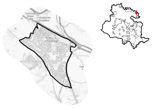
5.16.1 Burley-in-Wharfedale Parish comprises the village of Burley and the hamlets of Burley Woodhead and Stead. Located within Lower Wharfedale between Otley and Ilkley the parish is surrounded by Green Belt and has views of the moors on both sides of the dale. Burley-in-Wharfedale is one of four settlements located in the Wharfedale sub-area. Burley- in-Wharfedale forms part of the Shipley Parliamentary constituency and is within the Wharfedale Ward.
5.16.2 It has a population of 6,191 with a large percentage of the population (56%) falling within the working age category (16-64). Burley-in-Wharfedale has higher proportion of people over 65 years (24.1%) compared to the West Yorkshire (16.7%) average. The ethnic composition of Burley-in-Wharfedale mainly consists of people who have identified themselves as White British (95.8%). This is a notably higher proportion than the West Yorkshire average, but is similar to other smaller rural settlements in the District.
5.16.3 The settlement has an adopted Neighbourhood Plan. The Burley Neighbourhood Plan was adopted by the Bradford Council in 2020 and forms part of the development plan for Bradford District.
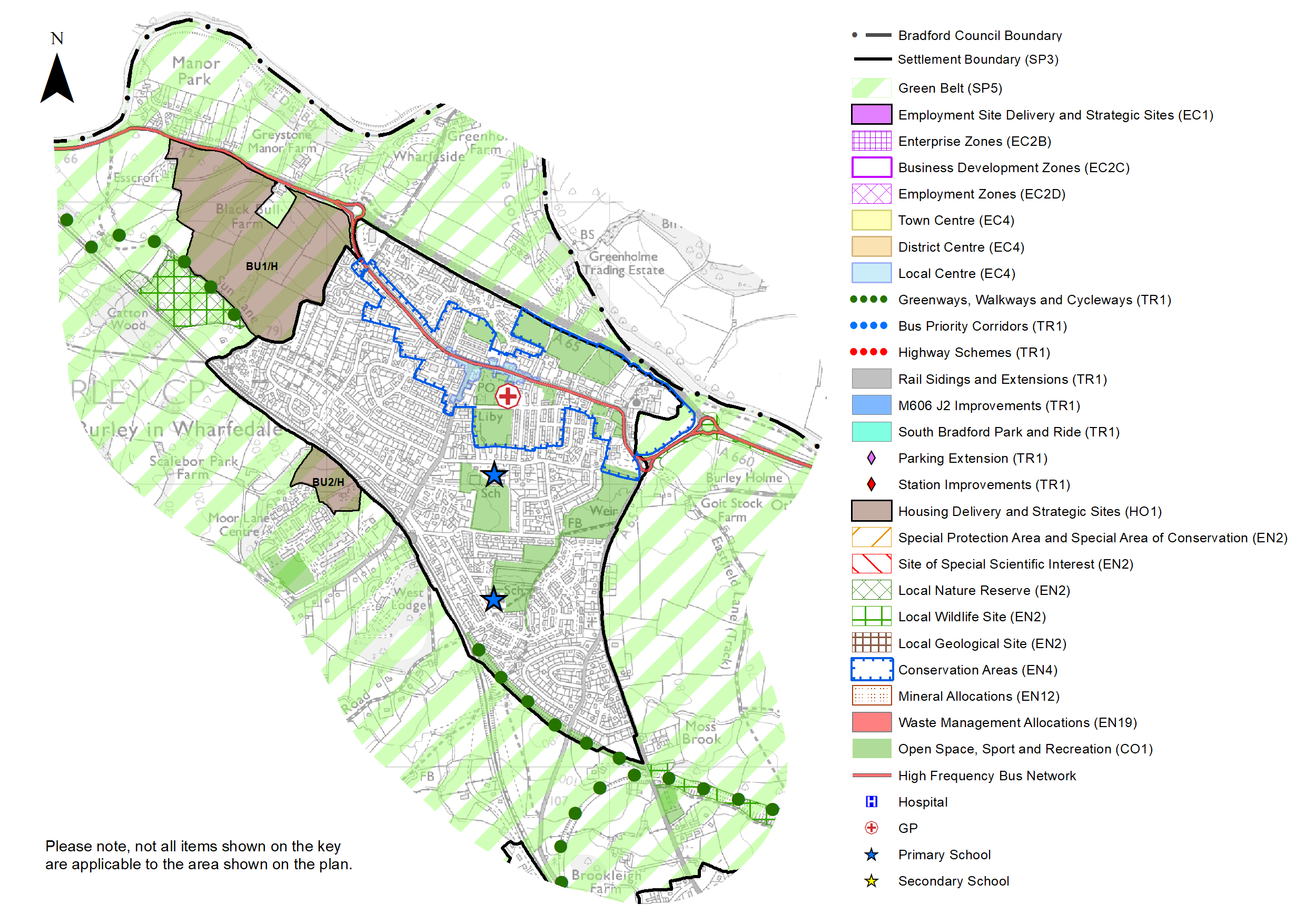
Figure 1: Location Plan
Planning for Prosperity
5.16.4 Burley-in-Wharfedale is defined as a Local Growth Centre and should therefore make a significant contribution to meeting the District's needs for housing, employment and provide for supporting community facilities.
Economy and Employment
5.16.5 There are limited employment opportunities within the settlement with the largest employment sectors in terms of local workforce being health (20.9%), education (12.5%) and professional, scientific and technical services (12.1%) according to Business Register and Employment Survey (BRES) data. Local businesses in Burley are generally centred around professional, scientific and technical services, construction and arts and entertainment sectors. There are no designated employment areas within the village with most residents having to commute out of the settlement to larger centres to access a wider range of employment.
5.16.6 The economic activity rate for Burley at 74.3% is above the West Yorkshire average (68.5%) as are the number of full-time, part-time and self-employed people. The average annual household income in Burley at £49,263 is well in excess of the sub-regional average at £38,499.
5.16.7 No specific employment land allocation is proposed for this Local Groth Centre, although under Policy SP6 economic growth and investment will continue to be supported particularly with a focus upon the priority sectors within the Wharfedale corridor of health, digital and professional services.
Retail
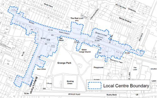
5.16.8 The Burley-in-Wharfedale local centre is set out below in Figure 2 and has been subject to a review as part of the Retail and Leisure Study (2019). The study found that since 2012, the amount of units in the centre has remained the same, however it is noted that there are differences in the overall composition, including an increase in the number and proportion of units in leisure service and retail service use. It is also noted that there is a reduction in the proportion of units in convenience, comparison and financial service use. Overall the centre is considered attractive and viable with a need to minimise the dispersal of retail uses where possible to protect long term interests.
Figure 2: Burley-in-Wharfedale Local Centre
Transport and Access
5.16.9 Burley is primarily a residential commuter settlement. Burley-in-Wharfedale railway station serves the village of Burley-in-Wharfedale. The station lies on the Wharfedale Line between Ilkley and Leeds / Bradford Forster Square.
5.16.10 The main bus services are provided by the Keighley Bus Company (Transdev Blazefield), with the 962 providing a bus service to Ilkley and Otley hourly. The A65 and A660 are the primary trunk roads linking Burley with Ilkley to the west and Otley to the east. Both of these have localised traffic management issues. Most people use the car to travel to work, some 60% of journeys with multiple-car ownership above West Yorkshire averages. Therefore, given the frequency of travel and the preferred mode of travel, new development in Burley will need to be considered in terms of the road infrastructure both within the Wharfe valley, and also along the main commuting routes to Leeds and Bradford.
5.16.11 Despite Burley's good rail connections, only 17% of journeys to work are made by rail. The line along the Wharfe Valley provides fast and convenient services to the employment and services in the key regional centres of Leeds and Bradford. At peak times these services already run at capacity and with new development and increased population, upgrading should be considered.
5.16.12 There are a number of footpaths and bridleways which penetrate the village and directly connects it to the wider countryside providing opportunities for walking and cycling. Proposals for the Wharfedale Greenway, which would link Ilkley with Burley and Otley with a traffic free route for safe walking and cycling, are supported in the plan (TR1.A.5) which will seek to safeguard a route following further detailed feasibility work for when funding allows implementation.
5.16.13 In relation to digital connectivity, average broadband download speeds in Burley is 26.76 megabites per second – significantly lower than the West Yorkshire average (44.57), and there are no premises where speeds are below the Universal Service Obligation (USO)[1].
Planning for Homes
5.16.14 There are 2663 dwellings within the settlement area. A large proportion of these properties are owner occupied (82%) which is well in excess of the West Yorkshire average (63.4%). Nearly 8% of properties are private rented, with the remainder being made up of socially and other rented properties.
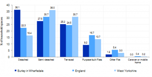
5.16.15 Burley has a varied mix of house types ranging from older terraced properties and cottages located around the historic core, accounting for 25.2%, with more modern detached (36.1%) and semi-detached (27.5%) houses where the village expanded during the latter half of the twentieth century. 9.2% of the properties comprise flats. Figure 3 below provides further information.
5.16.16 Average house prices in Burley are £310,671 which is far higher than the than the West Yorkshire average of £183,194. The total affordability ratio between house prices and annual earnings which is usually used as a proxy for number of years' worth of earnings required for a house deposit is 5.03 compared to a West Yorkshire average of 2.96.
Figure 3: Burley – Dwelling Type Breakdown
5.16.17 Delivering new housing is a key part of the overall development strategy for Burley-in- Wharfedale. It will ensure that the housing needs and aspirations of local people can be met, together with those of future residents, including the provision of market and importantly affordable housing. Burley has a strong local housing market, and further growth will support the economy and sustain Burley's role as a Local Growth Centre.
5.16.18 Policy SP8 in the local plan sets out a minimum requirement of 625 dwellings to be delivered in Burley-in-Wharfedale during the plan period. These will be delivered through a mix of committed sites (those under construction or have planning permission but have not yet commenced) and allocations. Table 1 below sets out the housing position for Burley, which also includes the application of non-implementation or discount rates for planning permissions and allocations.
Table 1: Burley-in-Wharfedale - Summary of Housing Requirement and Supply
|
Housing Target |
625 units |
|
Carried Forward Commitments |
93 |
|
Commitment Discounted by 10% |
84 |
|
Remaining Allocation Requirement |
541 |
|
Identified Allocations |
610 |
|
Allocations Discounted by 10% |
549 |
|
Total Supply Contribution from Allocations |
549 |
5.16.19 Once the commitments are discounted and removed from the supply this leaves a residual allocation requirement of 541 units. The evaluated total site supply of housing units from preferred allocation sites equates to 610 units which is in turn discounted by 10% for non-implementation or reduced delivery, leaving a final allocation contribution of 549 units across all sites, which is slightly above the remaining allocation requirement (541 units) but is reflective of site yield and the practicalities of redefining strong settlement boundaries. The Council will be supportive of additional proposals for new homes on additional small sites, particularly those that provide a redevelopment opportunity to bring forward land which has been previously used. Support will also be provided to developers who wish to redevelop larger sites and/or buildings for new homes not currently identified, subject to all relevant policies in the Local Plan.
5.16.20 Burley is heavily constrained by Green Belt with no practical brownfield or non-Green Belt growth options available or identified. In delivering the target for new homes in Burley in Wharfedale it has been necessary to make changes to the adopted green belt. Policy SP5 sets out The Councils approach and justification for Green Belt releases to accommodate new development and lists the sites proposed for allocation which current lie within or partly within the Green Belt. Two Green Belt release sites have therefore been identified as preferred housing site allocations to meet Burley's housing requirement, which have potential to support a wide range of housing types and are set out in Table A and identified on the Policies Map and the Site Pro Formas below together with the local strategies map for each plan area. This includes the large site at Sun Lane (BU1/H) to the West of the settlement. This site has planning approval (16/07870/MAO), but which is currently subject to call in and is to be re-determined by the Secretary of State.
5.16.21 Development of site allocations should be in accordance with specified development guidelines and approximate site provision figures and all other relevant policies of this Local Plan.
Planning for Places and Communities
Green Belt, Natural Landscape and Historic Character
5.16.22 The Green Belt forms a tight boundary around the built-up area of Burley providing little room for growth and expansion. The local landscape with dry stone walls, hedges, mature trees and views of open moorland is one of the area's outstanding features and this distinctive landscape setting will be conserved and enhanced through the Plan. It lies within the Wharfedale Landscape Character Area which describes the land surrounding the settlement as being 'enclosed pasture' to the south, with 'floodplain pasture' to the north and east.
5.16.23 Within Burley-in-Wharfedale Parish there are 82 statutory Listed Buildings and Ancient Monuments. Burley itself has 1 Grade I listed building and 64 Grade II listed buildings. The settlement has one conservation area and 20 open space sites totalling approximately 22.21ha.
5.16.24 Burley's heritage reflects that of a former Georgian and Victorian village, set against the rural backdrop of the Wharfe Valley and surrounding moorland. The village is focussed around a core centre with most through traffic now diverted around the village on the A65. Consequently, it has a generally pleasant bustling nature. The settlement is fairly contained with distinctive boundaries and the area retains a rural, leafy feel although its industrial history is still evident.
Green Infrastructure (GI), Ecology, Open Space and Flood Risk
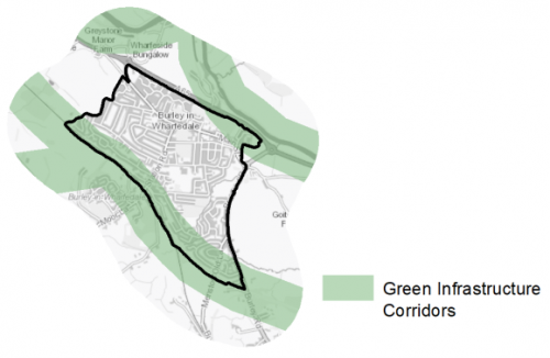
5.16.25 The settlement has a range of corridors and spaces that contribute towards its Green and Blue Infrastructure network. Key corridors include the River Wharfe corridor to the East and North, the rail corridor to the West of the settlement and former Burley Disused railway line to the South. Burley has been identified as having additional opportunities for building the GI network through the settlement. The main GI corridors are detailed below in Figure 3.
Figure 3: Green Infrastructure Corridors
5.16.26 The settlement lies within 2500m of the South Pennine Moors Special Protection Area (SPA) and has a Local Nature Reserve off Sun Lane plus a wide range of ecologically important habitat networks along the western edge of the settlement.
5.16.27 The settlement area of Burley has 20 sitesidentified as open space covering a total area of 22.21ha. There are a number of key siteswithin the Burley settlement area including:
- Grange Park
- Burley-in-Wharfedale Cricket Club
- Burley House Field
- East End Allotments
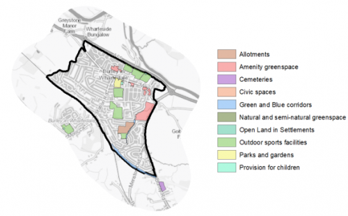
5.16.28 Open Space in the settlement has deficits and imbalance in provision between the different typologies of open space that currently exist. There are good levels of provision of Amenity space, Allotments and Green and Blue Corridors but significant deficits of Natural and Semi-natural Greenspace, Parks and Gardens, Open Land in Settlements and Cemeteries. Burley is surrounded by open countryside which may partly compensate for the lack of Open Land in Settlements. The Sun Lane nature reserve is also in close proximity to the settlement and partly fulfils the need for provision of this type of space. The settlement would benefit from additional park space provision to the west of the existing settlement where access is poorer. Figure 4 shows the location and type of open space in the settlement.
Figure 4: Burley-in-Wharfedale – Open Space Overview
5.16.29 Incidents of fluvial flooding and flood risk are mainly associated with the River Wharfe to the East and North of the settlement. Surface water flood risk has been identified through Sun Lane, Main Street and Station Road.
Community Infrastructure – Education, Health and Utilities
5.16.30 Burley has a wide range of community facilities to meet the day to day needs of local people. These include post offices, places of worship, community halls/centres, playgrounds, a leisure centre and swimming pool, a library and various sporting facilities. The settlement is served by two primary schools (Burley Oaks Primary School and Burley and Woodhead C of E Primary School) and the closest secondary is in Ilkley. Pupils attainment at key stage 1, 2 and 4 for average points is higher than both the national (England) and West Yorkshire averages.
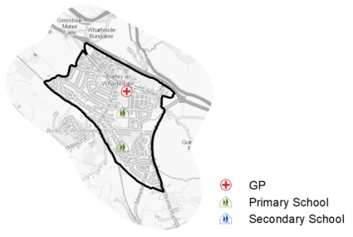
5.16.31 Burley has an NHS registered healthcare facilities within the town. Grange Park Surgery is the local GP's surgery. Secondary (acute) healthcare is provided at Wharfedale Hospital approximately 6km away. Average life expectancy for Burley residents is 84 years for men and 86 years for women, which is well above the West Yorkshire and England averages. Healthy life expectancy is 70 years for men and 71 years for women, which again is well above West Yorkshire and England averages. Figure 5 below shows the location of local schools and medical facilities.
Figure 5: Schools and Medical Facilities
5.16.32 When planning for the long-term development, it is vital that new development is supported by the appropriate infrastructure. The capacity, quality and accessibility of services and facilities are all key components in ensuring people can enjoy living, working and visiting the area. The Council will continue work with key infrastructure providers and others including the Local Education Authority, Clinical Commissioning Group and utilities providers to determine the impacts of future growth and development on local infrastructure capacity and provision. Further infrastructure details will be published through the Local Infrastructure Plan and as part of the Regulation 19 stage of the local plan.
|
Local Area Strategy and Plan – Burley-in-Wharfedale The key elements of the local area strategy for Burley include:
|
(243) Consultation Question 118
Burley-in-Wharfedale Local Area Strategy
The Local Plan sets out a local area strategy for Burley.
Q. Please provide any comments you may have on the area strategy?
If you have an alternative to the approaches undertaken, please provide further details and evidence in support.
Preferred Site Allocations and Site Pro Formas
5.16.33 The preferred housing site allocations are detailed below in Table A. This table is subsequently followed by site pro formas for each preferred site allocation providing a summary of key site information and characteristics.
Table A: Housing - Preferred Allocations
|
Site Ref |
Site Name |
Dwellings |
|
BU1/H |
Sun Lane / Ilkley Road |
500 |
|
BU2/H |
Scalebor House, Moor Lane |
110 |
|
Total |
610 |
(186) Consultation Question 119
Burley-in-Wharfedale: Site Allocations and Site Pro Formas
The Local Plan sets out a series of preferred site allocations. If you wish to make representations on any of the sites proposed, please provide site reference and feedback under this question.
If you wish to propose an additional or alternative site(s) to the preferred allocations listed, please also provide a plan with a red line and any further details in support.
[1] Universal Service Obligation (USO) - download speeds at or above 10Mbit/s and upload speeds at or above 1Mbit/s including non-matched records and zero predicted speeds
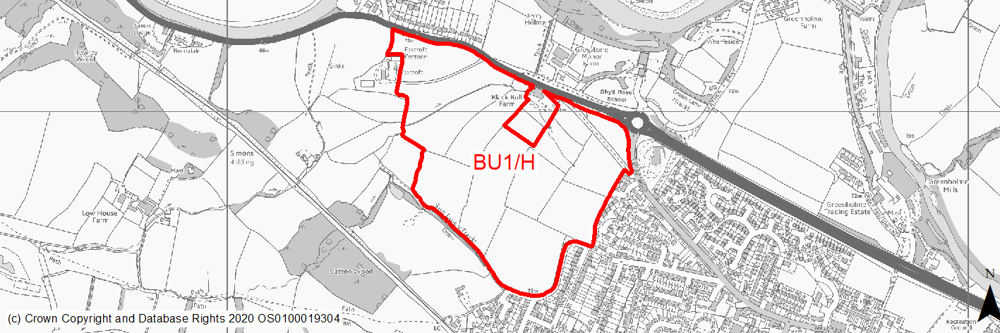
(104) BU1/H - Sun Lane, Ilkley Road
Site location
Local Growth Centre- Burley in Wharfedale
Ward
Wharfedale Ward
Site description
The site consists of a large area of open pasture fields on the western edge of the settlement. The site is directly adjacent to the A65: Ilkley Road which borders the site to the north. To the
south, the site is bounded by Sun Lane, which is adjacent to Sun Lane Local Nature Reserve. The eastern boundary of the site is formed by the existing built up area. The site comprises predominantly of grazing land, and contains a number of trees and hedgerows along field boundaries. A water course runs through the north-western portion of the site. A small barn is located along the northern part of the site to the west of Black Bull Farm. The site has planning approval (16/07870/MAO) currently subject to call in and is to be re-determined by the Secretary of State.
Proposed Allocation
Housing
SHLAA referencce
BU/001
Indicative no. dwellings
500
Site area (Gross) (ha)
25.69
Ownership
Private
Delivery timescales
Deliverable/Developable (0-11 years)
Type (PDL/Greenfield)
Greenfield
Green Belt
Yes
Flood Zone
Flood Zone 1 and Flood Zone 2. Potential to be mitigated by avodiance through site layout.
Potential site access
This site can be accessed from existing roads with local improvements/mitigation measures. Acceptable site access demonstrated through recent planning application via a new roundabout from the A65 Ilkley Road, with a secondary access from Ilkley Road / Main Street.
Public Transport Accessibility
Bus: The majority of site is within 400m of a bus stop with at least four services every hour.
Rail: The nearest railway station is Burley (to the south east), which is beyond 800m distance from the site.
Sustainability Appraisal
No major adverse or beneficial effects have been predicted. Minor positive effects were predicted for a range of socio-economic themed SA Objectives due to the benefits of new residential development for the local economy, as well as the location of the site in relation to transport links and health facilities. However, access to both primary and secondary schools is somewhat limited due to distance, and residents may find they need to travel up to 1.4km to access basic services and amenities, which is significantly beyond the target distance.
The site is large and greenfield and Green Belt, with TPO woodland in the north-west and north-east corners and the south-west corner falling within the Sun Lane, Burley in Wharfedale LNR, which is also an LWS. Minor adverse effects were predicted for a range of natural environment themed SA Objectives as a result of the impacts of new development on such a site. The site falls within the SSSI Impact Risk Zones for the South Pennine Moors SAC/SPA/SSSI, meaning consultation with Natural England would be required as part of a planning application for 50 dwellings or more. A small area in the north of the site falls within FZ2 and there is a small extent of land at high risk of surface water flooding, with more land at low and medium risk; careful consideration would need to be given to the layout of the development. The site is 200m east of the Nidderdale AONB at its closest point and could potentially affect views into or out of the AONB given its size, but any impact from new development is expected to be limited by the presence of existing built form screening it from view.
The site wraps around two Grade II Listed Buildings and is 60m north-west of the Burley in Wharfedale Conservation Area; development at this large greenfield site would be likely to alter the settings of these.
Habitats Regulations Assessment
This site falls within 2.5km of the South Pennine Moors SPA/SAC a HRA must be undertaken to ensure there are no significant effects on these protected sites in terms of impact on supporting habitat which might be functionally linked to the SPA and recreational pressures. Developments within these zones must comply with Policy SP11; an SPD is being produced to provide further guidance.
Green Belt
Based on planning judgement the site has a moderate potential impact on the Green Belt.
• The site is located in a moderate Green Belt parcel.
• The site makes a moderate contribution to the purposes of including land in the Green Belt.
• The site has a moderate potential for sprawl and would have a major impact on openness.
• There is potential to create a strong Green Belt boundary to the north and south but the site has weak existing boundaries to the west.
Constraints and Opportunities
• The site is located within the 2.5km buffer of the SPA/SAC/SSSI impact zone.
• Impact on landscape character, the setting of a grouping of Grade II listed farm building and remains of temporary roman camp. Potential for the heritage assets to be conserved or enhanced through site layout/design.
• Site adjacent Sun Lane Nature Reserve and grassland habitat network.
• The site includes hedgerows and some mature trees some with areas of TPO woodland to north and east of the site.
• Small areas of the site within flood zone 2 with areas of medium/high SWFR within site.
• Education infrastructure - opportunity to facilitate additonal primary school capacity for the settlment.
• The site is currently considered a deliverable Preferred Option site due to the extant planning approval (16/07870/MAO), which is to be re-determined by the Secretary of State following the issue of a Consent Order by the High Court. The site will be subject to further review through the Local Plan preparation following any decision by the SOS.
Development considerations
• New on-site open space and GI links to be created.
• Improvements needed to make site fully accessible to public transport, inlcuding to the rail station.
• Ecological surveys to identify any impacts and mitigate accordingly. Mitiagation/Enhacement to Sun Lane Nature Reserve.
• Sensitive and high quality site design to mitigate any impact on landscape character and heritage assets.
• Field boundaries/hedgerows and mature trees retained and enahanced where possible.
• Provision of new vehicular access and associated local highway improvements needed.
• Improved pedestrian/cycle links to village and rail station.
• Compensatory Green Belt enhancement required.
• Requirement to facilitate additional Primary school capacity.
• Mitigation of surface water flood risk/drainage issues.
Conclusion/Summary
This is a sustainably located Green Belt site adjoining the settlement boundary, which would deliver an estimated 250-500 dwellings.
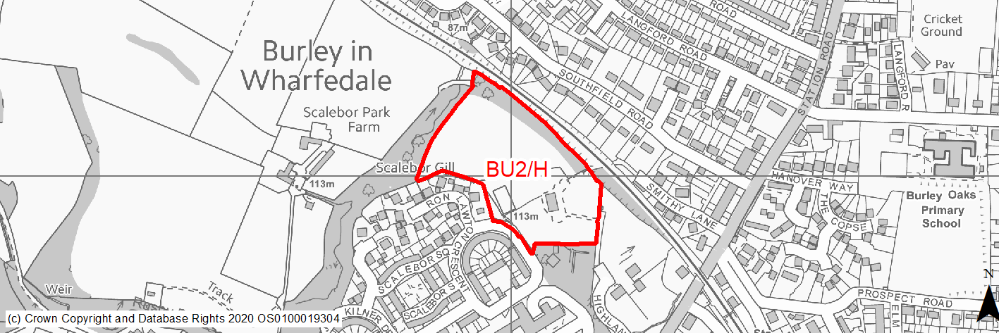
(205) BU2/H - Scalebor House, Moor Lane
Site location
Local Growth Centre- Burley in Wharfedale
Ward
Wharfedale Ward
Site description
House and garden and field between railway line and redeveloped former hospital site currently washed over by green belt.
Proposed Allocation
Housing
SHLAA referencce
BU/013
Indicative no. dwellings
110
Site area (Gross) (ha)
3.15
Ownership
Private
Delivery timescales
Developable (5-11 years)
Type (PDL/Greenfield)
Greenfield (site contains some existing buildings)
Green Belt
Yes
Flood Zone
Flood Zone 1
Potential site access
Access for this site could be achieved via the existing develpment to the west (Ron Lawton Cresent) but this will require a new access to be created and permission secured from the relevant landowners.
Public Transport Accessibility
Bus: The site is not located within 400m of a bus stop with at least four services every hour.
Rail: The site is located within 800m of a railway station Burley (to the south east).
Sustainability Appraisal
The site could deliver a major positive effect for residents on the health SA Objective as a result of being within the target distances for all necessary health facilities.
Minor positive effects were predicted for nearly all other socio-economic themed SA Objectives due to the benefits of new residential development for the local economy as well as the location of the site in relation to transport links, local services and amenities, education facilities and employment areas.
No major adverse effects have been predicted for the site, but minor adverse effects were predicted for a range of natural environment themed SA Objectives, primarily as a result of the impacts of new development on a predominantly greenfield and Green Belt site adjacent to TPO woodland and deciduous woodland priority habitat. There is a surface waterbody 15m west of the site, and a second with 100m, both of which could be affected by the development.
Habitats Regulations Assessment
This site falls within 2.5km of the South Pennine Moors SPA/SAC a HRA must be undertaken to ensure there are no significant effects on these protected sites in terms of impact on supporting habitat which might be functionally linked to the SPA and recreational pressures. Developments within these zones must comply with Policy SP11; an SPD is being produced to provide further guidance.
Green Belt
Based on planning judgement the site has a low potential impact on the Green Belt.
• The site is located in a low Green Belt parcel.
• The site makes a low contribution to the purposes of including land in the Green Belt.
• The site has a moderate potential for sprawl and would have a low impact on openness.
• There is potential to create a moderate defensible boudnary but limited opportunity to create a stronger Green Belt boundary than the existing boundary.
Constraints and Opportunities
• The site is located within the 2.5km buffer of the SPA/SAC/SSSI impact zone.
• Potential ecological constraints, inlcuding wildlife habitat network and mature trees.
• No existing access available and will require new acess to be created.
Development considerations
• Higher density development due to proximity to rail station.
• Potential opportunity for housing mix to include specialist older persons housing.
• Ecological surveys to identify any impacts and mitigate accordingly.
• Boundary and mature trees retained and enahanced, in particular along the northern boundary.
• Provision of new vehicular access through exisitng developement to the west and associated highway improvements needed.
• Improved pedestrian/cycle links to village and rail station.
• Compensatory Green Belt enhancement required.
Conclusion/Summary
This is a sustainably located Green Belt site adjoining the settlement boundary, which would deliver an estimated 110 dwellings.