
Draft Bradford District Local Plan - Preferred Options (Regulation 18) February 2021
Ilkley
Introduction
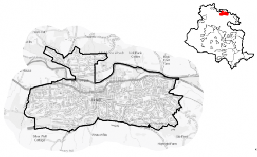
5.17.1 Ilkley is a former spa town situated in the Wharfe Valley, at the southern end of the Yorkshire Dales. The town is located approximately 22km to the north of Bradford city centre on the A65, the main transport route connecting Leeds to Skipton and beyond. The town is surrounded by Green Belt and dramatic and sensitive Pennine moorland landscapes, with Ilkley Moor/Rombolds Moor located directly to the South and the Nidderdale Area of Natural Beauty (AONB) to the North and the River Wharfe flowing through the centre of the town.
5.17.2 Ilkley is the principal town of Wharfedale with its public administrative, cultural, retail, tourism and leisure functions with excellent rail and bus connections with Bradford and Leeds, and is now primarily a commuter settlement. It is one of four settlements located in the Wharfedale sub-area. Ilkley falls within the Keighley Parliamentary Constituency and within the Ilkley Ward.
5.17.3 Ilkley has a population of 14,334, with a below average percentage of this population (54.2%) falling within the working age category (16-64). Ilkley has higher proportion of older persons aged over 65 (28.4%) and lower proportion of children aged below 16 years (17.4%) compared to the West Yorkshire and England averages. The ethnic composition of Ilkley is primarily made up of people who identify themselves as White British (94%), this is a higher proportion than the West Yorkshire average (78.4%). This is a notably higher proportion than the West Yorkshire average, but is similar to other rural settlements in the District
5.17.4 The settlement has an emerging Neighbourhood Plan. Consultation on Regulation 19 of the Ilkley Neighbourhood Plan was undertaken in 2019 and once adopted will form part of the development plan for Bradford district.
Figure 1: Location Plan
Planning for Prosperity
5.17.5 The Local Plan settlement hierarchy identifies Ilkley a one of the three principal towns in the District. This means it is a local focus for housing, employment, shopping, leisure, education, health and cultural activities and facilities.
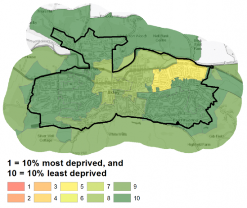
5.17.6 Ilkley is a relatively affluent area. The Ilkley ward is ranked 29th of 30 wards in the District for the 2019 Index of Multiple Deprivation where 1 is the most deprived (Manningham ward) and 30 is the least deprived (Wharfedale).
Figure 2: Index of Multiple Deprivation – Ilkley
Economy and Employment
5.17.6 The average income is £49,118 per household, which is significantly higher than the West Yorkshire average of £38,499. There are 6,770 people (70.2%) who are economically active in the area, similar to the West Yorkshire average. As a Principal Town, Ilkley is the focus for levels of development appropriate to its size for employment, retail, leisure and tourism.
5.17.7 There are employment opportunities within the town with most jobs being focussed around the retail or service sector. The town centre has a small office market, which is the most active in Wharfedale. Typically, future business demand in Wharfedale is from local businesses that want smaller space. There are a number of protected employment areas within the town, which provide local employment opportunities. The protection of existing employment stock is important for sustainability and growth. Tourism is also a continuing and major financial and employment contributor to the Ilkley economy.
5.17.8 No specific employment allocation is proposed for this Principal Town, although under Policy SP6 economic growth and investment will continue to be supported particularly with a focus upon the priority sectors within the Wharfedale corridor of health, digital and professional services.
Retail
5.17.9 Ilkley is a popular retail and leisure destination, with its location close to the Yorkshire Dales National Park and attracts a high number of tourists to the centre. The retail provision in Ilkley is centred around the town centre. Brook Street accommodates the majority of national operators in Ilkley. The Tesco on Springs Lane, Booths supermarket on Lower Wellington Road and M&S Foodhall unit on Station Plaza are the anchor foodstores in the town centre, with additional provision at the Co-op Food store on Bolton Bridge Road. There is strong representation of high-quality independent retailers throughout the centre, with a concentration along the Victorian parade of shops at The Grove. The vacancy rate in Ilkley town centre is well below the UK average in terms of both the number of units and proportion of floorspace. Ilkley Town Centre also provides a strong and varied service and leisure offer that includes a theatre and events venue, a cinema, two gyms, a rock climbing facility, and a range of restaurants, cafés, bars and pubs
5.17.10 The Ilkley town centre is set out below in Figure 3 and has been subject to a review as part of the Retail and Leisure Study (2019). Key issues for Ilkley Town Centre are:
The rural location means that car travel could be more preferential than other centres;
the provision of parking is also an issue for the centre for private vehicles and coaches;
The lack choice and range of convenience retailers in the centre
Figure 3: Ilkley Town Centre
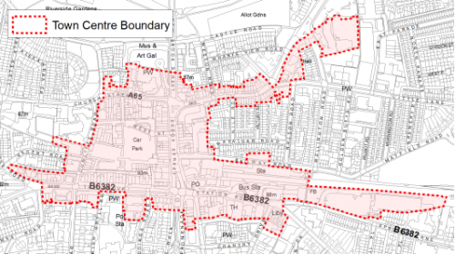
5.17.11 Ilkley Town Centre is considered a strong and healthy town centre performing in accordance with its role as a market town and important service centre for the north of the District. It is an attractive centre, which benefits from a number of period and historic buildings, tree lined streets and landscaped public spaces. There is significant potential to attract further retail and leisure uses to the centre should suitable premises become available
Transport and Access
5.17.12 Ilkley is located along the A65, with Skipton located 15km to the north-west and Bradford city centre 22km to the south via the A6037/38. The main town centre car park is located on Cunliffe Road/South Hawksworth Street and accommodates approximately 200 car parking spaces. Given Ilkley's more rural location, car travel is higher to the centre than others, as indicated through the surveys. 17% of households have no car in Ilkley, compared with 29% across West Yorkshire. Ilkley has been the subject of a parking study and parking review to identify and solve long-standing issues with parking in the town.
5.17.13 Ilkley has a good provision of public transport facilities, with the train station on Railway Road and additional station at Ben Rhydding providing frequent services on the Wharfedale line to the nearby centres in Leeds and Bradford. A half-hourly service is available to Bradford Forster Square Retail Park station (via Shipley) and Leeds. In addition, bus services are available to the outlying areas, including Leeds, Harrogate, Skipton and York.
5.17.14 There are numerous footpaths and bridleways leading out of the settlement into the countryside and connecting with the wider public rights of way network. This includes the Dales Way long distance path. Proposals for the Wharfedale Greenway, which would link Ilkley with Burley, Addinghham and Otley with a traffic free route for safe walking and cycling, are supported in the plan which will seek to safeguard a route following further detailed feasibility work for when funding allows implementation.
5.17.15 Strategic transport infrastructure projects to be delivered within the plan period and protected routes are set out on the Policies Map with the local plan. Key initiatives within the Ilkley are detailed in Table 1 below.
Table 1: Ilkley Transport Projects
|
Policies Map Ref. |
Project Name |
|
TR1.A.5 |
Wharfedale Greenway- waking and cycling route |
5.17.16 In relation to digital connectivity the average broadband download speed is 55.53Mbits/s which is higher than average the West Yorkshire average (44.57). There are no premises with broadband speeds below the Universal Service Obligation level.
Planning for Homes
5.17.17 There are 6,703 dwellings within the settlement area. A large proportion of these properties are owner occupied (78.9%) which is higher than both the West Yorkshire and England averages. Nearly 12.4% of properties are private rented. The proportion of social rented properties is much lower (6.4%) than the West Yorkshire average.
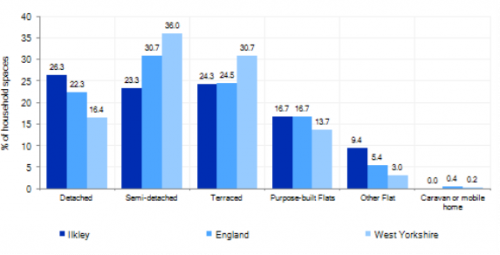
5.17.18 Ilkley has a varied mix of house types ranging from older terraced properties and cottages located around the historic core, (accounting for 24.3%), with more modern detached homes (26.3%) and semi-detached (23%) houses and flats (16.7%). Figure 4 below provides further information.
5.17.19 Average house prices in Ilkley are £411,353 which is far higher than the than the West Yorkshire average of £183,194. The total affordability ratio between house prices and annual earnings which is usually used as a proxy for number of years' worth of earnings required for a house deposit is 5.3 compared to a West Yorkshire average of 2.96. Affordability is therefore an issue for newly forming households wanting to live in the area.
Figure 4: Ilkley – Dwelling Type Breakdown
5.17.20 The delivery of new housing is a key part of the development strategy for Ilkley. It will ensure that the housing needs and aspirations of local people can be met, together with those of future residents, including the provision of market and importantly affordable housing. Ilkley has a strong local housing market, and further growth will support the economy and sustain the provision of services and facilities and Ilkley's role as a Principal Town.
5.17.21 Policy SP8 in the local plan sets out a minimum requirement of 300 dwellings to be delivered in Ilkley during the plan period. This requirement will be delivered through a mix of committed sites that are either under construction or which have planning permission but have not yet started, as well as sites to be allocated in the Local Plan. Table 1 below sets out the housing position for Ilkley, which also includes the application of non- implementation or discount rates for planning permissions and allocations.
Table 1: Ilkley - Summary of Housing Requirement and Supply
|
Housing Target |
300 units |
|
Carried Forward Commitments |
22 |
|
Commitment Discounted by 10% |
20 |
|
Remaining Allocation Requirement |
280 |
|
Identified Allocations |
314 |
|
Allocations Discounted by 10% |
283 |
|
Total Supply Contribution from Allocations |
283 |
5.17.22 Once the commitments are discounted and removed from the supply, this leaves a residual allocation requirement of 280 units. The evaluated total site supply of housing units from the preferred allocation site equates to 314 units, which is in turn discounted by 10% for non-implementation or under delivery leaving a final allocation contribution of 283 units across all allocations, which is slightly above the remaining allocation requirement (283 units) but is reflective of site yields of the identified sites.
5.17.23 Ilkley is heavily constrained by Green Belt with very limited deliverable brownfield and non- Green Belt growth options within the settlement available or identified. In delivering the target for new homes in Ilkley it has been necessary to make some changes to the adopted green belt. Policy SP5 sets out the Council's approach and justification for Green Belt releases to accommodate new development and lists the sites proposed for allocation, which current lie within or partly within the green belt. One small mixed site (brownfield/greenfield) within the settlement, along with three Green Belt sites have been identified as the preferred housing options for Ilkley to meet the housing requirement. Further information on these proposed allocations is set out in Table A and are identified on the Policies Map and the Site Pro Formas below, together with the local strategies map for each plan area. The Council will also be supportive of additional proposals for new homes on additional small sites, particularly those that provide a redevelopment opportunity to bring forward land which has been previously used. Support will also be provided to developers who wish to redevelop larger sites and/or buildings for new homes not currently identified, subject to all relevant policies in the Local Plan
5.17.24 Development of housing site allocations should be in accordance with specified development guidelines and approximate site provision figures and all other relevant policies of this Local Plan.
Planning for Places and Communities
Green Belt, Natural Landscape and Historic Character
5.17.25 The Green Belt forms a tight boundary around the built-up area of Ilkley providing little room for growth and expansion. Ilkley is set within a scenic and sensitive natural landscape, with Ilkley Moor forming the town's backdrop to the south. The Gritstone moorland landscape is one of the area's outstanding features and this distinctive and sensitive landscape setting will be conserved and enhanced through the Plan. Ilkley falls within Natural England's Southern Pennines National Character Area and within Bradford Landscape Character Areas Rombalds Ridge and Wharfedale. To the south of Ilkley is Ilkley Moor, which falls within the Rombalds Ridge Landscape Character Area. The town lies within the Wharfedale Landscape Character Area which describes the land surrounding the settlement as being 'enclosed pasture', with 'floodplain pastures' restricted to a narrow area within the valley floor to the south of the river Wharfe and the wooded incline lies to the north of the river adjacent to Ilkley. The Rombalds landscape character area is very sensitive to change and the Wharfedale character area has moderate sensitivity.
5.17.26 Ilkley's heritage reflects that of a former Georgian spa town, set against the rural backdrop of the Wharfe Valley and surrounding moorland. The town is focussed around a historic core of traditional millstone grit buildings with most traffic passing through the town centre on the A65. Today, Ilkley has a busy centre and still retains its tourist identity. The settlement is fairly contained with distinctive boundaries and the area retains a semi-rural, leafy feel with a long established character with mature tree cover throughout the town and large private gardens of the many detached residences and villas contributing to this mature landscape.
5.17.27 Within the settlement area there are 75 statutory Listed Buildings and Ancient Monuments and a Historic Park and Garden (Heathcote Ilkley). It has, 11 Grade I listed buildings, 3 Grade II* and 61 Grade II listed buildings. The settlement also has three conservation areas (Ilkley, Ben Rhydding, Ilkley and Middleton) and 65 open space sites consisting of 107ha.
Green Infrastructure (GI), Ecology, Open Space and Flood Risk
517.28 Ilkley has a network of green spaces and green corridors, linking different areas of the town, open spaces and gardens within the town, and the town itself to the wider countryside. These mainly wooded corridors carry surface water from Ilkley Moor to the River Wharfe and are important for local wildlife and form part of the Wildlife habitat network. The River Wharfe forms an important blue/green corridor and habitat network running through the heart of the area with Middleton Woods to the North of the town another important green corridor. The main GI corridors are detailed below in Figure 5.
Figure 5: Green Infrastructure Corridors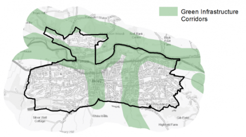
5.17.29 The South Pennine Moors Special Protection Area (SPA) is located directly to the South of the settlement. The settlement lies within 2500m of the SPA with areas to the south of the town which border with Ilkley Moor within 400m of the SPA. There are a number of important wildlife sites and priority habitats in and around Ilkley, which include the designation of the River Wharfe as a site of wildlife importance and part of the local habitat network with areas to the North and West of the town part of the woodland and grassland Local Wildlife Network. Sites of ecological significance around Ilkley include Ben Rhydding Gravel Pits (Local Nature Reserve)and Middleton Woods Local Wildlife Sites.
5.17.30 There are a wide range of number of open spaces and recreations sites within the Ilkley settlement area. In regards to formal open space the settlement area of Ilkley has 65 sitesidentified as open space covering an area of 107.57ha. There are a number of key siteswithin the Ilkley settlement area including:
- Riverside Gardens/Ilkley
- Park
- Middleton Sports
- Ground/East Holme Fields
- Ilkley Cricket Club
- Olicanian Cricket Club
- Ilkley Lido
- Ilkley Cemetery
- West View Park
- Ilkley Lawn Tennis and
- Squash Club
- Dansk Way Allotments
- Ben Rhydding Golf Club
- Ben Rhydding Sports Club
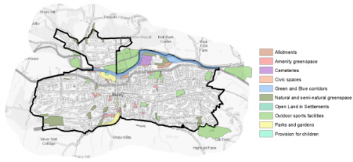
5.17.31 There are good levels of provision of open space provision generally, in particular for outdoor sports, natural and semi-natural greenspace, green and blue corridors, cemeteries and civic space within the settlement. There are however notable deficits in amenity greenspace, open land in settlements, parks and gardens and provision for children. Ilkley is surrounded by open countryside and has a good level of Natural and Semi-natural Greenspace within the settlement area which may partly compensate for the lack of amenity greenspace and open land in settlements. With regard to distribution there is a reasonably good spread of sites throughout Ilkley, however there are here are also two key residential areas with low levels of provision, particularly to the west and south east. The town would benefit from additional park and play area provision either to the west or east of the existing settlement where access is poorer. Figure 6 illustrates the location and type of open space across the settlement.
Figure 6: Ilkley Open Space Overview
5.17.32 Incidents of fluvial flooding and flood risk are mainly associated with the River Wharfe and Beck's/tributaries running through the settlement. There are areas of higher flood risk within and around the settlement mainly around the River Wharfe along the valley floor with large areas of functional flood plain and Flood Zones 2 and 3. There are numerous smaller streams and becks descending from the moors that can be a source of flood risk in extreme rainfall events. Tributaries of the River Wharfe within the area include Backstone Beck. A Natural Floodplain Management (FNM) project on Backstone Beck in Ilkley began 2019 led by the Environment Agency and in conjunction with Bradford Council.
Community Infrastructure – Education, Health and Utilities
5.17.33 Ilkley has a local civic role which provides a range of services and facilities for its population; these include a health centre on Alexandra Road, GP surgery, a library, two post offices, two community centres, a town hall and an outdoor swimming pool (Lido).
5.17.34 In regards to Education, Ilkley has 4 primary schools and 1 secondary school which serve the local catchment area including the surrounding towns and villages; these include: All Saints CE Primary, Ashlands Primary, Ben Rhydding Primary. The Sacred Heart Catholic Primary and Ilkley Grammar School Secondary school. Pupils attainment levels at Key Stage 1, 2, 3, 4 is above the West Yorkshire and national (England) average scores.
5.17.35 Ilkley has a number of NHS registered healthcare facilities within the area. Secondary (acute) healthcare is provided at Bradford Royal Infirmary and Wharfedale Hospital in Otley in the Leeds District around 7km to the East.
5.17.36 Average life expectancy at birth for Ilkley residents is higher than the West Yorkshire and England average, with healthy life expectancy of 71 years for men and women which is significantly higher than the West Yorkshire and national average. Figure 7 shows the location of local schools and medical facilities.
Figure 7: Schools & Medical Facilities in Ilkley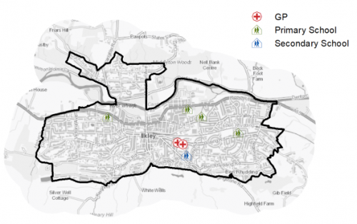
5.17.37 When planning for the long-term development, it is vital that new development is supported by the appropriate infrastructure. The capacity, quality and accessibility of services and facilities are all key components in ensuring people can enjoy living, working and visiting the area. The Council will continue work with key infrastructure providers and others including the Local Education Authority, Clinical Commissioning Group and utilities providers to determine the impacts of future growth and development on local infrastructure capacity and provision. Further infrastructure details will be published through the Local Infrastructure Plan and as part of the Regulation 19 stage of the local plan.
|
Local Area Strategy and Plan – Ilkley The key elements of the local area strategy for Ilkley include:
|

(263) Consultation Question 120
Ilkley Local Area Strategy
The Local Plan sets out a local area strategy for the Ilkley.
Q. Please provide any comments you may have on the area strategy?
If you have an alternative to the approaches undertaken, please provide further details and evidence in support.
Preferred Site Allocations and Site Pro Formas
5.17.38 The preferred housing site allocations are detailed below in Table A. This table is subsequently followed by site pro formas for each preferred site allocation providing a summary of key site information and characteristics.
Table A: Housing - Preferred Allocations
|
Site Ref |
Site Name |
Dwellings |
|
IL1/H |
Wheatley Grove |
130 |
|
IL2/H |
Skipton Road East |
20 |
|
IL3/H |
Coutances Way |
155 |
|
IL4/H |
Stockheld Road |
9 |
|
Total |
314 |
(145) Consultation Question 121
Ilkley Site Allocations and Site Pro Formas
The Local Plan sets out a series of preferred site allocations. If you wish to make representations on any of the sites proposed, please provide site reference and feedback under this question.
If you wish to propose an additional or alternative site(s) to the preferred allocations listed, please also provide a plan with a red line and any further details in support.
(750) IL1/H - Ben Rhydding Drive, Wheatley Grove
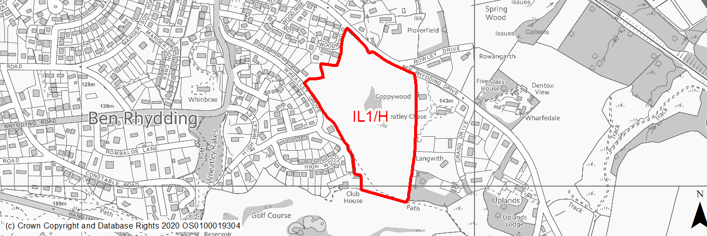
Site location
Principal Town- Ilkley
Ward
Ilkley Ward
Site description
Sloping field with central copse and trees on boundaries.
Proposed Allocation
Housing
SHLAA referencce
IL/009
Indicative no. dwellings
130
Site area (Gross) (ha)
7.18
Ownership
Private
Delivery timescales
Developable 6-11 years
Type (PDL/Greenfield)
Greenfield
Green Belt
Yes
Flood Zone
Flood Zone 1
Potential site access
Access to the site is available from Wheatley Gorve, which would require a new access. Access is not considered available from Ben Rhydding Drive.
Public Transport Accessibility
Bus: The site is not located within 400m of a bus stop with at least four services every hour.
Rail: The majority of the site is located within 800m of a railway station (Ben Rhydding) to the West.
Sustainability Appraisal
There are unlikely to be any significant effects, either positive or negative, on any SA Objective arising as a result of development at this site.
Minor positive effects were predicted for a range of socio-economic themed SA Objectives due to the benefits of new residential development for the local economy as well as the location of the site in relation to transport links, health facilities and employment areas. However, access to both primary and secondary schools is somewhat limited due to distance, and residents may need to travel up to 2km to access services and amenities, which is significantly beyond the target distance.
The site is greenfield and Green Belt and adjoins deciduous woodland priority habitat and TPO trees. Minor adverse effects were predicted for a range of natural environment themed SA Objectives, primarily as a result of the impacts of new development on such a site. The site falls within the SSSI Impact Risk Zones for the South Pennine Moors SAC/SPA/SSSI, meaning a consultation with Natural England is required as part of any planning application for 50+ dwellings to ensure no adverse effects on the Moors, which are 350m north-west of the site. The site is 800m south-west of the Nidderdale AONB, though development is not expected to impact views into or out of the AONB due to being surround by exiting similar built form in Ilkley. Two small waterbodies are within 100m of the site, the water quality of which could be affected by development here.
Habitats Regulations Assessment
This site falls within 2.5km of the South Pennine Moors SPA/SAC a HRA must be undertaken to ensure there are no significant effects on these protected sites in terms of impact on supporting habitat which might be functionally linked to the SPA and recreational pressures. Developments within these zones must comply with Policy SP11; an SPD is being produced to provide further guidance.
Green Belt
Based on planning judgement the site has a moderate potential impact on the Green Belt.
• The site is located in a moderate Green Belt parcel.
• The site makes a moderate contribution to the purposes of including land in the Green Belt.
• The site has moderate potential for sprawl and would have a moderate impact on openness.
Constraints and Opportunities
• The site is located within the 2.5km buffer of the SPA/SAC and SSSI impact zone.
• Protected mature trees within site and along boundaries.
• Improved pedestrian/ccyle links through the site and to Ben Rhydding Station.
• Topography - the site slopes down form south to north with steeper areas of land to the south of the site.
• Site borders priority habitat to the south east.
• PROW through the site.
Development considerations
• Ecological/archaelogical surveys required to identify any impacts and mitigate accordingly.
• SPA/SAC Zone B - habitat mitigation required.
• New on site open space/SANG and new and enhanced GI links through the site.
• Sensitive site design to mitigate any impact on landscape character.
• Provision of new vehicular access from Wheatley Grove.
• Mitigation of surface water flood risk/drainage issues.
• Compensatory Green Belt enhancment required.
• Development to protect and incorporate existing trees within site and increase the tree cover.
• Improved pedestrian and cycle links through the site and to Ben Rhydding Station.
Conclusion/Summary
This is a sustainably located Green Belt site adjoining the settlement boundary, which would deliver an estimated 130 dwellings.
(322) IL2/H - Skipton Road east

Site location
Principal Town- Ilkley
Ward
Ilkley Ward
Site description
Scrubby overgrown and partially despoiled land to the east of "Hollin Hall". The land was formerly part of a larger site, but has now been subdivided. Site comprises former railway sidings and is contained by mature trees along its northern boundary.
Proposed Allocation
Housing
SHLAA referencce
IL/011B
Indicative no. dwellings
20
Site area (Gross) (ha)
1.18
Ownership
Private
Delivery timescales
Developable 6-11 years
Type (PDL/Greenfield)
Greenfield
Green Belt
Yes
Flood Zone
Flood Zone 1
Potential site access
There is an existing access to the site directly onto the A65. This would require improvement.
Public Transport Accessibility
Bus: The site is located within 400m of a bus stop (Leeds Road A65) with three services every hour.
Rail: The site is not located within 800m of a railway station. The nearest station is Ilkley (approx 1.8 km to the east of the site).
Sustainability Appraisal
No major adverse or beneficial effects have been predicted. Minor positive effects were predicted for some socio-economic themed SA Objectives due to the benefits of new residential development for the local economy as well as the location of the site in relation to transport links and employment areas. However, residents’ access to health and education facilities and basic services and amenities would be somewhat limited due to the site’s location on the outskirts of Ilkley.
The site is within 1km of the Nidderdale AONB, though development here is not expected to impact views into or out of the AONB due the topography screening it from view and its location adjacent to existing built form. The site has a limited extent of land at low, medium and high risk of surface water flooding, although through a careful layout of the development, this is expected to be avoided. There is a Grade II Listed Building adjoining the site’s south-western corner, and a second with 45m; development on this open site could adversely alter the settings of these sensitive heritage assets.
Habitats Regulations Assessment
This site falls within 2.5km of the South Pennine Moors SPA/SAC a HRA must be undertaken to ensure there are no significant effects on these protected sites in terms of impact on supporting habitat which might be functionally linked to the SPA and recreational pressures. Developments within these zones must comply with Policy SP11; an SPD is being produced to provide further guidance.
Green Belt
Based on planning judgement the site has a moderate potential impact on the Green Belt.
• The site is located in a major Green Belt parcel.
• The site makes a major contribution to the purposes of including land in the Green Belt.
• The site has moderate potential for sprawl and would have a moderate impact on openness.
Constraints and Opportunities
• The site is located within the 2.5km buffer of the SPA/SAC and SSSI impact zone.
• Impact on heritage setting of lsited building/ landscape character.
• Flood risk - parts of the site to the north within flood zones 2/3 and areas of surface water flood risk.
• GI links through the site.
Development considerations
• Ecological surveys to identify any impacts and mitigate accordingly.
• Protect and enhance habitat networks through and adjacent the site.
• Mitigation of surface water flood risk/drainage issues.
• SPA/SAC Zone B - habitat mitigation required.
• Improved exisitng vehicular access onto A65.
• Sensitive site design to mitigate any impact on landscape character and setting of listed building.
• Compensatory Green Belt enhancment required.
• Development to protect existing boudnary trees and increase tree cover.
Conclusion/Summary
This is a sustainably located Green Belt site adjoining the settlement boundary, which would deliver an estimated 30 dwellings.
(696) IL3/H - Coutances Way
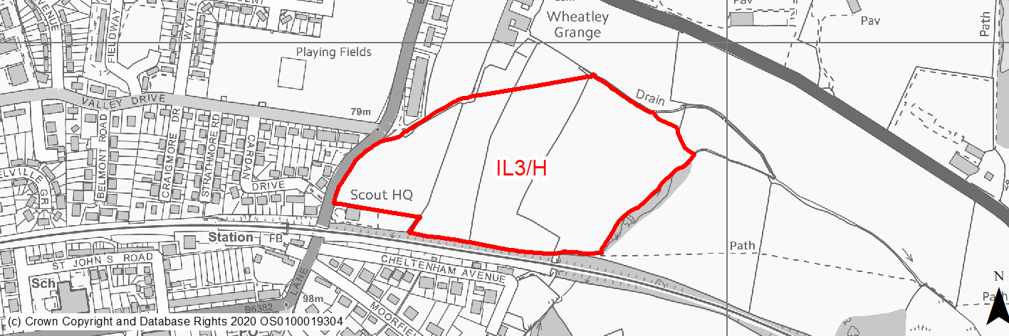
Site location
Principal Town- Ilkley
Ward
Ilkley Ward
Site description
Open pasture fields to the East of Wheatley Lane sloping downwards from south to north, containing wooded areas and hedgerows. The site is bounded by the railway line and scout hut to the south and Wheatley Lane to the West with open fields and listed farm buildings to the South and East.
Proposed Allocation
Housing
SHLAA referencce
IL/014
Indicative no. dwellings
155
Site area (Gross) (ha)
7.41
Ownership
Council
Delivery timescales
Developable 6-11 years
Type (PDL/Greenfield)
Greenfield
Green Belt
Yes
Flood Zone
Flood Zone 1, small part to the north within Flood Zone 2 and Flood Zone 3
Potential site access
Access to the site is available from the existing field access point from Wheatley Lane, which would need improvement. Further highways assessment is required given the scale of site.
Public Transport Accessibility
Bus: The site is located within 400m of a bus stop (Wheatley Lane, Leeds Road) with at least four services every hour.
Rail: The site is located within 800m of a railway station (Ben Rhydding) to the south.
Sustainability Appraisal
See individual Sustainability Appraisal site comment in the accompanying report.
Habitats Regulations Assessment
This site falls within 2.5km of the South Pennine Moors SPA/SAC a HRA must be undertaken to ensure there are no significant effects on these protected sites in terms of impact on supporting habitat which might be functionally linked to the SPA and recreational pressures. Developments within these zones must comply with Policy SP11; an SPD is being produced to provide further guidance.
Green Belt
Based on planning judgement the site has a major potential impact on the Green Belt.
• The site is located in a moderate Green Belt parcel.
• The site makes a major contribution to the purposes of including land in the Green Belt.
• The site has moderate potential for sprawl and would have a major impact on openness.
Constraints and Opportunities
• The site is located within the 2.5km buffer of the SPA/SAC and SSSI impact zone.
• Impact on setting of listed building (Wheatley Grange Farm Grade II Listed farmhouse and outbuilding.
• Impact on landscape character.
• Flood risk - parts of the site to the north within flood zones 2/3 and areas of surface water flood risk.
• Green Infrastrucutre links through the site.
• New site access Required.
• Potential opportunity to incorporate additional parking for Ben Rhydding Station.
Development considerations
• Ecological surveys to identify any impacts and mitigate accordingly.
• Heritage impact assessment/statement requried to identify any impacts and mitigate accordingly.
• Potential for areas of higher density development and specialist housing including older persons housing.
• Site specific FRA requried and mitigation of any surface water flood risk/drainage issues. Areas of higher flood risk to be avoided through sequential approach to site layout.
• SPA/SAC Zone B - habitat mitigation required.
• New vehicular access required from Wheatley Lane.
• The site will require a design brief masterplan to deliver sensitive high quality site design to mitigate any impact on landscape character and setting of listed buildings.
• New on site open space/SANG requiered within site.
• New pedestrian/cycle and enhanced GI links to including safeguarding/delivering the route of the Wharfedale Greenway through the site.
• Potential for additional car parking to serve Ben Rhydding Rail Station, subject to further highways feasibility.
• Compensatory Green Belt enhancement required and new defensible Green Belt boundary required to east of the site.
• Development to protect and incorporate existing trees/hedgerows within site and increase the tree cover.
Conclusion/Summary
This is a sustainably located Green Belt site adjoining the settlement boundary, which would deliver an estimated 155 dwellings.
(309) IL4/H - Stockheld Road
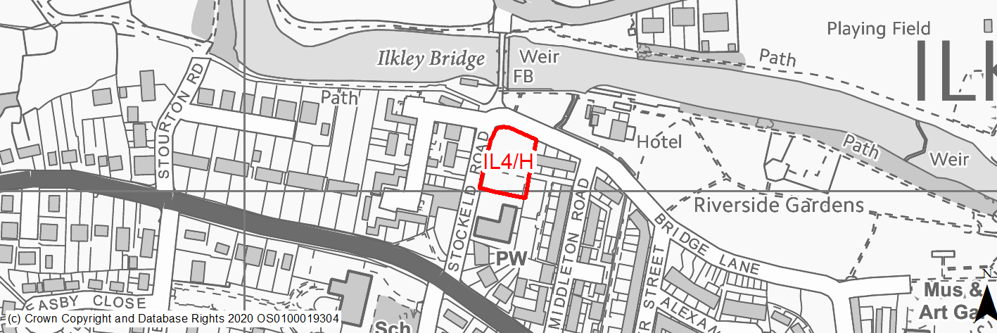
Site location
Principal Town- Ilkley
Ward
Ilkley Ward
Site description
The site consists of a sloping grassed area and tarmaced car park bounded by a low dry stone wall. The site is located between Stockeld Road and Bridge Lane and is adjacent to the church to the South.
Proposed Allocation
Housing
SHLAA referencce
IL/033
Indicative no. dwellings
9
Site area (Gross) (ha)
0.23
Ownership
Private
Delivery timescales
Deliverable 0-5 years
Type (PDL/Greenfield)
Mixed
Green Belt
No
Flood Zone
Flood Zone 1 and Flood Zone 2
Potential site access
Access to the site is available via Stokheld Road.
Public Transport Accessibility
Bus: The site is located within 400m of a bus stop with at least four services every hour (Skipton Road Westville Road).
Rail: The site is located just beyond 800m of a railway station (Ilkley) to the south east.
Sustainability Appraisal
Significant adverse effects have been predicted in relation to cultural heritage. This is because the site is currently undeveloped greenfield land and is located within the Ilkley Conservation Area and is 30m south of the Old Bridge Scheduled Monument. Although uncertain, a significant negative effect cannot be ruled out at this stage, particularly with regards to the Conservation Area. Minor adverse effects have been predicted for most natural environment themed SA Objectives, primarily as a result of the impacts associated with development on greenfield. The site coincides with the floodplain.
The site would provide residents here with excellent access to public transport options. It also provides generally good access to key services and amenities, schools, shops, cultural spaces and jobs. Access to healthcare facilities is somewhat more limited, with the nearest GP surgery and hospital being just outside the target distances.
Habitats Regulations Assessment
This site falls within 2.5km of the South Pennine Moors SPA/SAC a HRA must be undertaken to ensure there are no significant effects on these protected sites in terms of impact on supporting habitat which might be functionally linked to the SPA and recreational pressures. Developments within these zones must comply with Policy SP11; an SPD is being produced to provide further guidance.
Green Belt
N/A – Site not within the Green Belt.
Constraints and Opportunities
• The site is located within the 2.5km buffer of the SPA/SAC/SSSI impact zone.
• Impact on heritage and landscape character (site with conservation area and view/setting from the old pack horse bridge to the Church).
• Part of site within Flood Zone 2.
Development considerations
• Site is suitable for higher density and a landmark building.
• Heritage Statement requried and high quality sensitive site design to mitigate any impact on the conservation area/setting of scheduled ancient monument.
• Mitigation of drainage issues.
• Vehicular access from Stockeld Road.
• SPA/SAC Zone B - habitat mitigation required.
Conclusion/Summary
This is a sustainably located site within the settlement boundary, which would deliver an estimated 9 dwellings.