
Draft Bradford District Local Plan - Preferred Options (Regulation 18) February 2021
Addingham
Introduction
5.15.1 Addingham is situated in lower Wharfedale on the edge of the Yorkshire Dales National Park and less than 20 miles from the major cities of Bradford and neighbouring Leeds. The village is home to some 3,200 people and a variety of local shops, businesses and community facilities. It is one of four settlements located in the Wharfedale sub-area. Addingham is part of the Keighley Parliamentary Constituency.
5.15.2 Addingham has a long history as a farming and industrial settlement, yet until relatively recently remained a small linear village, clustered around road junctions and the main turnpike road. Over the past 30 years, its status has grown and it is now seen as a desirable commuter settlement for Ilkley, Skipton, Keighley, Bradford and Leeds.
5.15.3 The settlement has a population of 3,119 people with 48.8 % falling within the working age category (16-64) with a significantly higher proportion of persons over 65 (36.8%) compared to the West Yorkshire (16.7%) and England (18.4%) averages. It will be important to consider the needs of a growing, older population over the lifetime of the plan. The proportion of children aged 0-15 years (14.4%) is notably lower than the West Yorkshire average (20.6%).
5.15.4 The ethnic composition of Addingham is primarily made up of people who identify themselves as White British – account for 96.8%. This is a notably higher proportion than the West Yorkshire average (78.4%), but is similar to the other smaller rural settlements in the District.
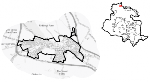
Figure 1: Location Plan
5.15.5 The settlement has an adopted Neighbourhood Plan. The Addingham Neighbourhood Plan was adopted by Bradford council in 2020 and forms part of the development plan for Bradford District.
Planning for Prosperity
5.15.6 The Local Plan settlement hierarchy identifies Addingham as one of Bradford District's 11 Local Service Centres. This means that it will see a smaller scale of development, comprising both market and affordable housing, as well as the protection of its local centre to help ensure the continued provision of economic activity in the area.
5.15.7 Craven ward is ranked 28th of 30 wards in the District for the Index of Multiple Deprivation where 1 is the most deprived (Manningham ward) and 30 is the least deprived (Wharfedale).
Economy and Employment
5.15.8 There are limited employment opportunities within the settlement. The largest employment sector is education at 15% of the population and retail at 15% and then health and social work at 11%.
5.15.9 Addingham has an important role as a local service centre providing a range of shops, pubs, services, small-scale manufacturing and many home-based operations. These businesses provide vital services for village residents and visitors, as well as a significant level of local employment. The village primary school is another important local employer. The Townhead Trading Centre is Addingham's only sizeable existing employment site providing a source of local employment, with the majority of working-age residents commuting to other employment centres, particularly Bradford, Leeds, Skipton and Keighley
5.15.10 The economic activity rate for Addingham at 67.7% is below the West Yorkshire average (68.5%) as are the number of full-time people, with above average part-time and self-employed people. The average annual household income in Addingham at £47,700 is well in excess of the sub-regional average at £38,499.
5.15.11 No specific employment land allocation is proposed for this Local Service Centre, although under Policy SP6 economic growth and investment will continue to be supported particularly with a focus upon the priority sectors within the Wharfedale corridor of health, digital and professional services.
Retail
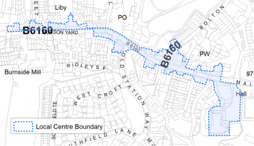
5.15.12 The Addingham local centre is set out below in Figure 2 and has been subject to a review as part of the Retail and Leisure Study (2019). Overall it is considered that Addingham is an attractive and healthy centre with a limited convenience offer and mix of other retail and service uses in the centre, reasonable for a centre of its size. Vacancy in the centre is relatively high having risen over the last decade. However, the slight decrease in vacancy seen over the last three years suggests that vacancy in the centre has now stabilised. Representation of leisure uses is strong and the vitality and viability of the centre is supported by its range of community uses, traditional village character and high quality environment
Figure 2: Addingham Local Centre
Transport and Access
5.15.13 Addingham is primarily a residential commuter settlement. The nearest rail station to the settlement is located in Ilkley on the Wharfedale Line and provides excellent rail connections to Bradford and Leeds.
5.15.14 The village benefits from two bus routes; the 62 – run by The Keighley Bus Company, which provides two buses an hour running between Keighley Bus Station and Leeds Bradford airport via Ilkley and Menston. There is also the 784 bus which runs from Otley via Ilkley to Skipton which runs hourly.
5.15.15 The A65/A6038 (Wharfedale corridor between Addingham and Bradford) is a key transport corridor in the District There are currently no significant transport schemes planned for the A65/A6038 corridor.
5.15.16 There are numerous footpaths and bridleways leading out of the settlement into the countryside and connecting with the wider public rights of way network. This includes the Dales Way long distance path, which runs adjacent to the settlement to the North East. Proposals for the Wharfedale Greenway, which would link Ilkley with Burley, Addinghham and Otley with a traffic free route for safe walking and cycling, are supported in the plan which will seek to safeguard a route following further detailed feasibility work for when funding allows implementation.
Planning for Homes
5.15.17 There are 1,587 dwellings within the settlement area. A large proportion of these properties are owner occupied (82%) which is higher than both the West Yorkshire and England averages, the rest are rented, the majority from private landlords.
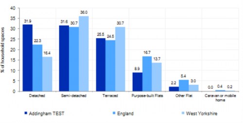
5.15.18 Addingham has a varied mix of house types ranging from older terraced properties and cottages located around the historic core, with more modern detached (31.9%) and semi- detached (31.6%) houses and flats (26%) constructed to the south and west of the 18th/19th century linear settlement. Figure 3 below provides further information.
Figure 3: Addingham Dwelling Type Breakdown
5.15.19 The average house price is £305,862 significantly higher than the West Yorkshire average of £183,194. The total affordability ratio between house prices and annual earnings which is usually used as a proxy for number of years' worth of earnings required for a house deposit is 5.6 compared to a West Yorkshire average of 2.96. Affordability is therefore an issue for newly forming households wanting to live in the area.
5.15.20 The delivery of new housing is a key part of the development strategy for Addingham. This will ensure that the housing needs of local people can be met, both in terms of market and affordable housing. New housing will also allow for the modest growth of the settlement, to attract new residents and to help sustain the provision of services and facilities.
5.15.21 Policy SP8 in the Local Plan sets out the housing requirement for the District distributed between the settlements and indicates that for the plan period Addingham should look to provide 175 dwellings. This requirement will be delivered through a mix of committed sites that are either under construction or which have planning permission but have not yet started, as well as sites to be allocated in the Local Plan. Table 1 illustrates a summary of the housing requirement and supply for the settlement.
Table 1: Addingham - Summary of Housing Requirement and Supply
|
Housing Target |
175 units |
|
Carried Forward Commitments |
13 |
|
Commitment Discounted by 10% |
12 |
|
Remaining Allocation Requirement |
163 |
|
Identified Allocations |
181 |
|
Allocations Discounted by 10% |
163 |
|
Total Supply Contribution from Allocations |
163 |
5.15.22 Once the commitments are discounted and removed from the supply, this leaves a residual allocation requirement of 163 units. The evaluated total site supply of housing units from the preferred allocation site equates to 181 units which is in turn discounted by 10% for non-implementation or under delivery leaving a final allocation contribution of 163 units.
5.15.23 Addingham is heavily constrained by Green Belt with limited deliverable brownfield and non-Green Belt growth options available or identified. Two small sites which are previously developed and one greenfield site within the settlement, along with five Green Belt sites have been identified as the preferred housing options for Addingham to meet the housing requirement. In delivering the target for new homes in Addingham it has been necessary to make some changes to the adopted green belt. Policy SP5 sets out The Councils approach and justification for green belt releases to accommodate new development and lists the sites proposed for allocation which current lie within or partly within the green belt.
5.15.24 Further information on these proposed allocations is set out in Table A and are identified on the Policies Map and the Site Pro Formas below, together with the local strategies map for each plan area. The Council will be supportive of additional proposals for new homes on additional small sites, particularly those that provide a redevelopment opportunity to bring forward land which has been previously used. Support will also be provided to developers who wish to redevelop larger sites and/or buildings for new homes not currently identified, subject to all relevant policies in the Local Plan. Development of housing site allocations should be in accordance with specified development guidelines and approximate site provision figures and all other relevant Policies of this Local Plan.
Planning for Places and Communities
Green Belt, Natural Landscape and Historic Character
5.15.25 Addingham is surrounded by Green Belt. The Green Belt forms a tight boundary around the built-up area of Addinham providing little room for growth and expansion. Addingham remains a highly attractive village with historic character and a special setting in the landscape and this distinctive landscape setting will be conserved and enhanced through the Plan. The settlement is surrounded by enclosed pastures and mixed woodland. On the northern side of the settlement the River Wharfe forms the boundary of the settlement, with floodplain pastures and enclosed pastures rising steeply up to the notable landmarks of Beamsley Beacon, Langbar and Middleton Moor. It lies within the Wharfedale Landscape Character Area which describes the land surrounding the settlement as being 'enclosed pasture' and Rombalds Ridge Moorland edge to the south, with 'floodplain pasture' to the north and east.
5.15.26 Within Addingham, there are 80 statutory grade II Listed Buildings and Ancient Monuments. Addingham's heritage reflects its long history as a farming and industrial settlement, yet until relatively recently remained a small linear village. The village is focussed around a historic core centre with most through traffic now diverted around the village on the A65. Consequently, Main Street is now a quieter local thoroughfare and has re-established its village characteristics.
Green Infrastructure (GI), Ecology, Open Space and Flood Risk
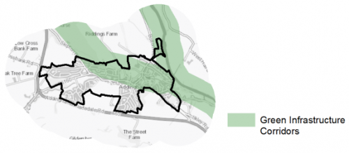
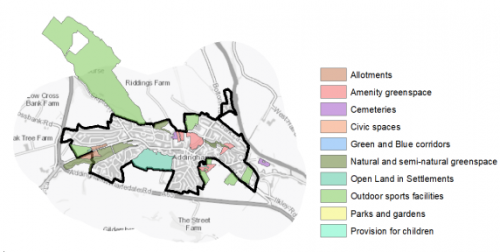
5.15.27 The settlement has a significant range of corridors and spaces that contribute towards its Green and Blue Infrastructure network. Key GI assets include the beck corridors throughout the village, especially along Town Beck, Back Beck and Marchup Beck and along the River Wharfe; and the green corridors North from the village centre toward the River Wharfe. The main GI corridors are detailed below in Figure 4.
Figure 4: Green Infrastructure Corridors
5.15.28 The southern part of the settlement lies within 2500m of the South Pennine Moors Special Protection Area (SPA) a habitat network, plus a wide range of locally important ecological and wildlife sites including the River Wharfe, Danny Palmer Nature Reserve and Hedgerows at Long Riddings.
5.15.29 The settlement area of Addingham has 25 sitesidentified as open space covering an area of 66.61ha. There are a number of key siteswithin the settlement area including:
- Addingham Golf Course
- Addingham Cricket Club
- Silsden Road Playing Field and play area
- Silsden Road Allotments
Designated Local Green Space within the settlement boundary include Marchup Ghyll, Manor Garth, Sugar Hill and Sawmill Pond (much of this space lying within the Conservation Area).
5.15.30 Addingham has a good amount and range of provision of open space serving the settlement and there is a good dispersal of spaces throughout Addingham. The two small play areas are located at either ends of the village. There is however no provision of more formal parks and gardens. Figure 5 shows the location and type of open space in the settlement.
Figure 5: Addingham – Open Space Overview
5.15.31 Incidents of fluvial flooding and flood risk are mainly associated with the River Wharfe to the East and North of the settlement and from the becks within the settlement itself, in particular around Bolton Road and Back Beck Lane There are areas of higher Surface Water Flood risk within the settlement, identified in particular around Main Street, Bolton Road, Back Beck Lane and Marchup Beck.
Community Infrastructure – Education, Health and Utilities
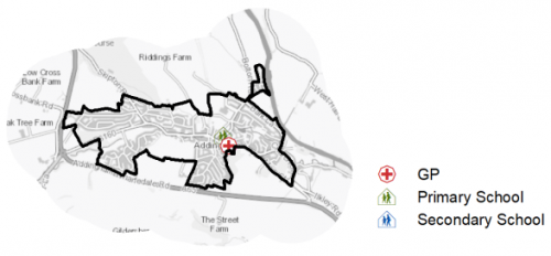
5.15.32 Addingham has 1 primary school, the closest secondary school is Ilkley Grammar. Pupils attainment levels at key stage 4 is 398.2. For key Stage 1 it is 16.4 and 30.6 for key stage 2. There is one GP surgery Addingham Medical Centre located on Main Street offering primary care services to local residents. Secondary (acute) healthcare is provided at Airedale General Hospital approximately 10km away. Figure 6 shows the location of local services in the village.
Figure 6: Addingham – Schools and GP Practices
5.15.33 When planning for the long-term development, it is vital that new development is supported by the appropriate infrastructure. The capacity, quality and accessibility of services and facilities are all key components in ensuring people can enjoy living, working and visiting the area. The Council will continue work with key infrastructure providers and others including the Local Education Authority, Clinical Commissioning Group and utilities providers to determine the impacts of future growth and development on local infrastructure capacity and provision. Further infrastructure details will be published through the Local Infrastructure Plan and as part of the Regulation 19 stage of the Local Plan.
|
Local Area Strategy and Plan - Addingham The key elements of the local area strategy for Addingham include:
|

(184) Consultation Question 116
Addingham Local Area strategy and Plan
Q. Please provide any comments you may have on the area strategy?
If you have an alternative to the approach undertaken, please provide further details and evidence in support.
Preferred Site Allocations and Site Pro Formas
5.15.34 The preferred housing site allocations are detailed below in Table A. This table is subsequently followed by site pro formas for each preferred site allocation proving a summary of key site information and characteristics.
Table A: Housing - Preferred Allocations
|
Site Ref |
Site Name |
Dwellings |
|
AD1/H |
Turner Lane |
20 |
|
AD2/H |
Parsons Lane |
14 |
|
AD3/H |
Main Street / Addingham Bypass (East) |
49 |
|
AD4/H |
Main Street / Addingham Bypass (West) |
38 |
|
AD5/H |
Chapel Street |
5 |
|
AD6/H |
Moor Lane |
24 |
|
AD7/H |
Turner Lane / Silsden Road |
23 |
|
AD8/H |
Church Street / Main Street |
8 |
|
Total |
181 |
(73) Consultation Question 117
Addingham Site Allocation and Site Pro Forma
The Local Plan sets out a preferred site allocation for Addingham. If you wish to make representations on the site proposed, please provide feedback under this question.
If you wish to propose an additional or alternative site(s) to the preferred allocation listed, please also provide a plan with a red line and any further details in support.
(177) AD1/H - Turner Lane
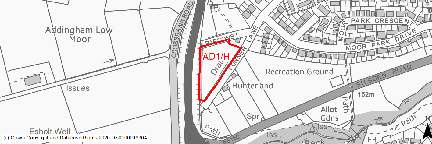
Site location
Local Service Centre -Addingham
Ward
Craven Ward
Site description
The site consists of a triangular shaped field used for grazing, with mature trees and low dry stone wall along the boundaries.
Proposed Allocation
Housing
SHLAA referencce
AD/001
Indicative no. dwellings
20
Site area (Gross) (ha)
0.61
Ownership
Private
Delivery timescales
Deliverable (0-5 years)
Type (PDL/Greenfield)
Greenfield
Green Belt
Yes
Flood Zone
Flood Zone 1
Potential site access
The site can be accessed from Turner Lane / Parsons Lane but access will require improvements. There is no direct access possible to the A65.
Public Transport Accessibility
Bus: Within 400m of a bus stop with two services every hour.
Rail: the nearest railway station is Ilkley (approx 5.5km to the south east), which is beyond 800m distance from the site.
Sustainability Appraisal
Development at this site would be unlikely to result in a significant effect, either positive or negative, on any SA Objective.
Minor positive effects were predicted for a range of socio-economic themed SA Objectives due to the benefits of new residential development for the local economy as well as the location of the site in relation to transport links, health facilities and employment areas. However, access to both primary and secondary schools is somewhat limited due to distance, and residents may find they need to travel up to 1.4km, significantly beyond the target distance, in order to access services and amenities.
Minor adverse effects were predicted for a range of natural environment themed SA Objectives, primarily as a result of the impacts of new development on a 100% greenfield and Green Belt site containing trees. There is a small surface water body 80m west of the boundary, which could be impacted by the development.
Habitats Regulations Assessment
This site falls within 2.5km of the South Pennine Moors SPA/SAC a HRA must be undertaken to ensure there are no significant effects on these protected sites in terms of impact on supporting habitat which might be functionally linked to the SPA and recreational pressures. Developments within these zones must comply with Policy SP11; an SPD is being produced to provide further guidance.
Green Belt
Based on planning judgement the site has a moderate potential impact on the Green Belt.
• The site is located in a moderate Green Belt parcel.
• The site makes a moderate contribution to the purposes of including land in the Green Belt.
• The site has a low potential for sprawl and would have a moderate impact on openness.
• There is opportunity to create a stronger Green Belt boundary than the existing boundary.
Constraints and Opportunities
• The site is located within the 2.5km buffer of the SPA/SAC.
• Mature trees and traditional stone wall along boundaries.
• Parsons Lane/Turner Lane requires improvement.
• Site adjacent GI link along Turner Lane.
Development considerations
• Ecological surveys to identify any impacts and mitigate accordingly.
• SPA/SAC Zone B- habitat mitigation required.
• Sensitive site design to mitigate any impact on landscape character.
• Boundary trees and traditonal stone wall contribute to local street character and should be retained and enhanced.
• Provision of new vehicular access from Parsons Lane/Turner Lane and associated improvements to Turner Lane needed.
• Compensatory Green Belt enhancement required.
Conclusion/Summary
This is a sustainably located Green Belt site adjoining the settlement boundary, which would deliver an estimated 20 dwellings.
(156) AD2/H - Parsons Lane
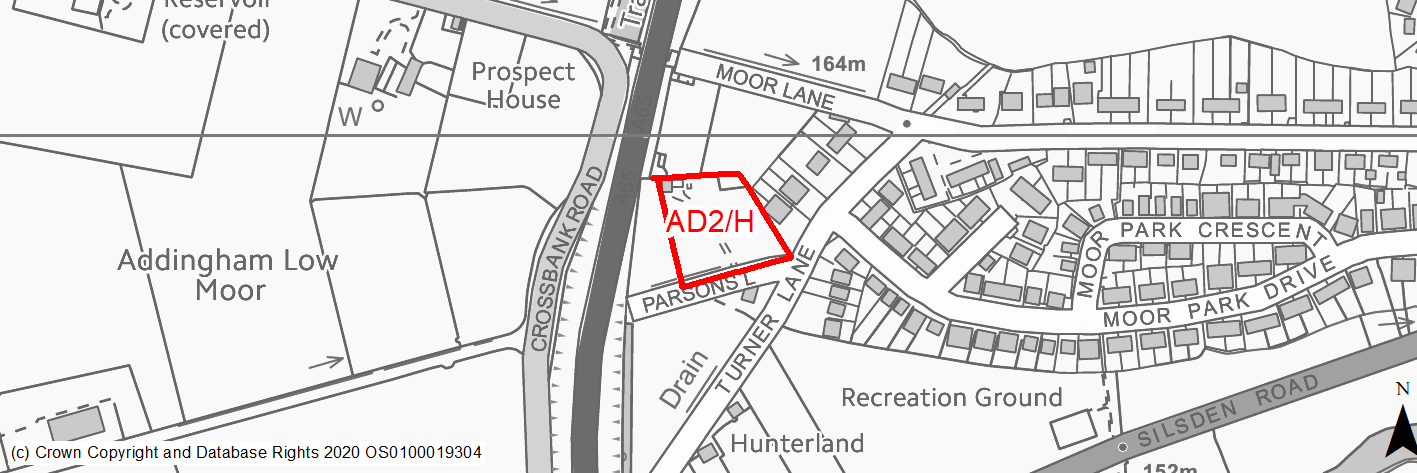
Site location
Local Service Centre -Addingham
Ward
Craven Ward
Site description
Grassed paddock sloping gently west to east off Parsons Lane.
Proposed Allocation
Housing
SHLAA referencce
AD/002D
Indicative no. dwellings
14
Site area (Gross) (ha)
0.4
Ownership
Private
Delivery timescales
Deliverable (0-5 years)
Type (PDL/Greenfield)
Greenfield
Green Belt
No
Flood Zone
Flood Zone 1
Potential site access
There is a field gate access point - from Parsons Lane. This access and Parsons lane would need improvements as it is currently an unadopted tarmac track.
Public Transport Accessibility
Bus: Within 400m of a bus stop with two services every hour.
Rail: the nearest railway station is Ilkley (approx 5.5km to the south east), which is beyond 800m distance from the site.
Sustainability Appraisal
No significant adverse effects predicted for the site. Minor adverse effects have been predicted for most natural environment themed SA Objectives, primarily as a result of the impacts associated with development on greenfield. The site generally offers access to buses, jobs, cultural spaces, and health facilities. Access to some key services is somewhat limited in the local area, including for schools.
Habitats Regulations Assessment
This site falls within 2.5km of the South Pennine Moors SPA/SAC a HRA must be undertaken to ensure there are no significant effects on these protected sites in terms of impact on supporting habitat which might be functionally linked to the SPA and recreational pressures. Developments within these zones must comply with Policy SP11; an SPD is being produced to provide further guidance.
Green Belt
N/A – Site not within the Green Belt.
Constraints and Opportunities
• The site is located within the 2.5km buffer of the SPA/SAC.
• Some mature trees and traditional wall along boundaires.
• Parsons Lane is an unadopted track and requires improvement.
• Site adjacent GI link along Turner Lane.
Development considerations
• SPA/SAC Zone B - habitat mitigation required.
• Boundary trees and traditional stone wall contribute to local street character and should be retained where possible with new planting.
• Vehicular and pedestrian access off Parsons Lane which requires improvement.
Conclusion/Summary
This is a sustainably located safeguarded land site within the settlement boundary, which would deliver an estimated 14 dwellings.
(141) AD3/H - Main Street / Addingham Bypass (East)
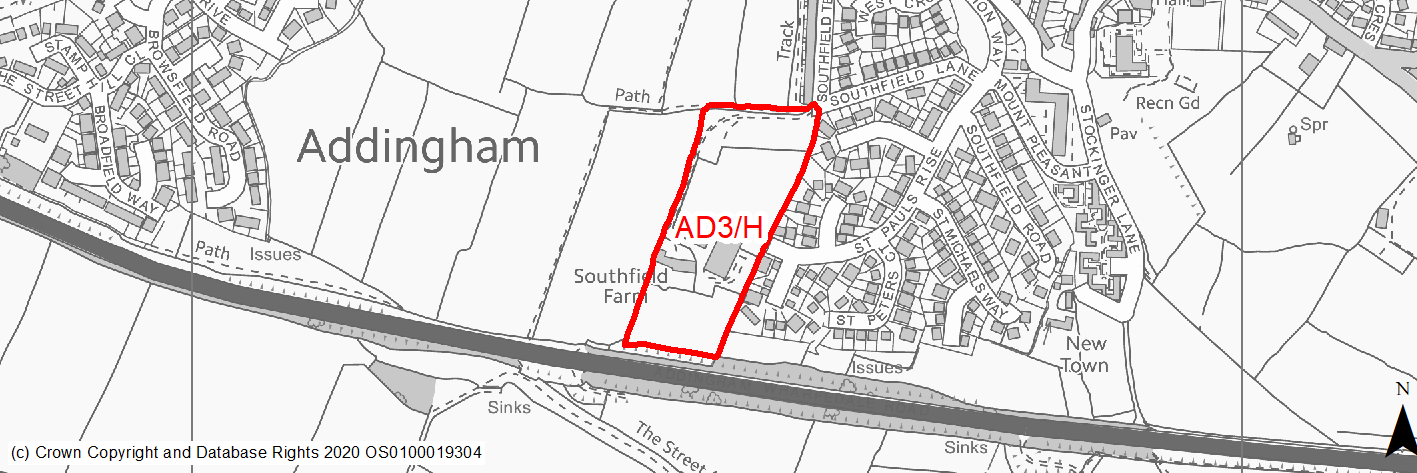
Site location
Local Service Centre -Addingham
Ward
Craven Ward
Site description
The site consists of a large sloping field in agricultural use as pastureland with mature trees/hedgerows on boundaries. There are existing converted agricultural buildings located within the site, accessed by an existing road to the western boundary.
Proposed Allocation
Housing
SHLAA referencce
AD/004a
Indicative no. dwellings
49
Site area (Gross) (ha)
2.37
Ownership
Private
Delivery timescales
Developable (5-11 years)
Type (PDL/Greenfield)
Mixed
Green Belt
Yes
Flood Zone
Flood Zone 1
Potential site access
Access to the site is available from existing estate roads to the East (St Paul's Rise/Southfield Lane).
Public Transport Accessibility
Bus: Site not located within 400m of a bus stop with two services every hour.
Rail: the nearest railway station is Ilkley (approx 5.5km to the south east), which is beyond 800m distance from the site.
Sustainability Appraisal
See individual Sustainability Appraisal site comment in the accompanying report.
Habitats Regulations Assessment
This site falls within 2.5km of the South Pennine Moors SPA/SAC a HRA must be undertaken to ensure there are no significant effects on these protected sites in terms of impact on supporting habitat which might be functionally linked to the SPA and recreational pressures. Developments within these zones must comply with Policy SP11; an SPD is being produced to provide further guidance.
Green Belt
See individual Green Belt site assessment in the accompanying report.
Constraints and Opportunities
• The site is located within the 2.5km buffer of the SPA/SAC.
• Mature trees/hedgerows and traditional stone wall along boudnaries.
• Site adjacent Addingham conservation area to the north.
Development considerations
• Ecological surveys to identify any impacts and mitigate accordingly.
• SPA/SAC Zone B - habitat mitigation required.
• Sensitive site design to mitigate any impact on landscape character and conservation area.
• Retain/enhance PROW running along northern boundary.
• Boundary trees and traditonal stone wall contribute to local character and should be retained and enhanced.
• Provision of new vehicular access from Southfield Lane/St Paul's Road.
• Compensatory Green Belt enhancement required.
Conclusion/Summary
This is a sustainably located Green Belt site adjoining the settlement boundary, which would deliver an estimated 49 dwellings.
(112) AD4/H - Main Street / Addingham Bypass (West)
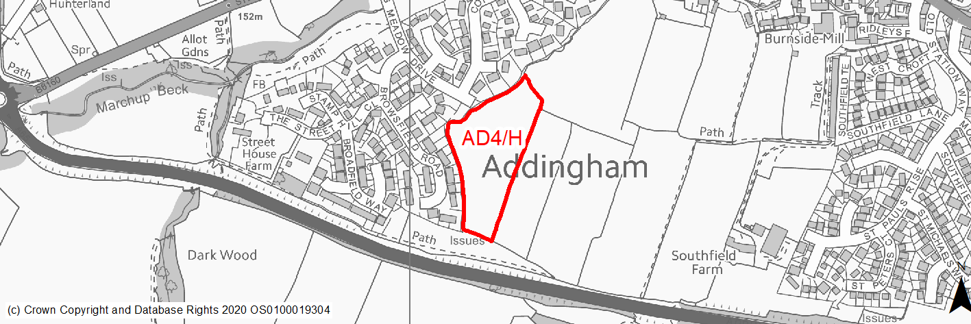
Site location
Local Service Centre -Addingham
Ward
Craven Ward
Site description
The site consists of a large sloping field in agricultural use as pastureland with mature trees/hedgerows on boundaries.
Proposed Allocation
Housing
SHLAA referencce
AD/004b
Indicative no. dwellings
38
Site area (Gross) (ha)
1.58
Ownership
Private
Delivery timescales
Developable (5-11 years)
Type (PDL/Greenfield)
Greenfield
Green Belt
Yes
Flood Zone
Flood Zone 1
Potential site access
Access to the site is available from existing estate roads to the West (Big Meadow Drive).
Public Transport Accessibility
Bus: Site located within 400m of a bus stop with two services every hour.
Rail: the nearest railway station is Ilkley (approx 5.5km to the south east), which is beyond 800m distance from the site.
Sustainability Appraisal
See individual Sustainability Appraisal site comment in the accompanying report.
Habitats Regulations Assessment
This site falls within 2.5km of the South Pennine Moors SPA/SAC a HRA must be undertaken to ensure there are no significant effects on these protected sites in terms of impact on supporting habitat which might be functionally linked to the SPA and recreational pressures. Developments within these zones must comply with Policy SP11; an SPD is being produced to provide further guidance.
Green Belt
See individual Green Belt site assessment in the accompanying report.
Constraints and Opportunities
• The site is located within the 2.5km buffer of the SPA/SAC.
• Mature trees and hedgerows along boundaries.
• Site adjacent Addingham conservation area to the north.
Development considerations
• Ecological surveys to identify any impacts and mitigate accordingly.
• SPA/SAC Zone B - habitat mitigation required.
• Sensitive site design to mitigate any impact on landscape character.
• Boundary trees and hedgerows contribute to local character and should be retained and enhanced.
• Provision of new vehicular access from Big Meadow Drive.
• Compensatory Green Belt enhancment required.
Conclusion/Summary
This is a sustainably located Green Belt site adjoining the settlement boundary, which would deliver an estimated 38 dwellings.
(154) AD5/H - Chapel Street
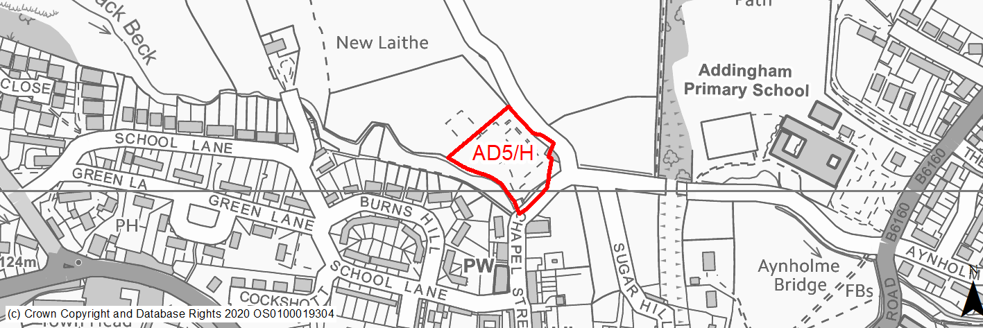
Site location
Local Service Centre -Addingham
Ward
Craven Ward
Site description
Cleared site of former school with remains of foundations present. The site has a degree of colonisation / seeding of vegetation and adjoins Back Beck and is enclosed by woodland and hedgerows.
Proposed Allocation
Housing
SHLAA referencce
AD/011A
Indicative no. dwellings
5
Site area (Gross) (ha)
0.47
Ownership
Council
Delivery timescales
Deliverable (0-5 years)
Type (PDL/Greenfield)
PDL
Green Belt
No
Flood Zone
Flood Zone 1
Potential site access
The existing access to the site is via extremely narrow Chapel Street. There is a potential opportunity to bring access in from School Lane as part of a comprehensive development of AD/011B. School Lane itself is substandard and will need improving to allow further development.
Public Transport Accessibility
Bus: Within 400m of a bus stop with two services every hour.
Rail: the nearest railway station is Ilkley (approx 4.5km to the south east), which is beyond 800m distance from the site.
Sustainability Appraisal
The only significant adverse effect predicted for this site relates to flood risk, due to the large area the site (relative to the site’s size) at a high risk of surface water flooding. It is unclear the extent to which this flood risk could be avoided through a careful layout. Minor adverse effects have been predicted for most other natural environment themed SA Objectives, primarily due to the impacts associated with development on partial greenfield, a TPO within the site and TPO woodland adjacent to and on site. Site is 840m south-west of the AONB and adjacent to the Addingham Conservation Area.
The site is well located to provide residents with good access to services and amenities, including shops, cultural spaces, jobs and schools with particularly good access to health facilities.
Habitats Regulations Assessment
Part of this site falls within 2.5km of the South Pennine Moors SPA/SAC a HRA must be undertaken to ensure there are no significant effects on these protected sites in terms of impact on supporting habitat which might be functionally linked to the SPA and recreational pressures. Developments within these zones must comply with Policy SP11; an SPD is being produced to provide further guidance.
Green Belt
N/A – Site not within the Green Belt.
Constraints and Opportunities
• The site is adjacent a designated Local Green Space but there are opportunities to enhance this as part of a comprehensive redevelopment alongside the adjacent site (SHLAA site AD/011B).
• There is potential risk of surface water flooding to the south of the site.
• Potential impact on the Addingham Conservation area/listed building.
• Part of the site is located within the 2.5km buffer of the SPA/SAC.
• Mature trees and potential ecological constraints. Part of the site or adjacent site (SHLAA site AD/011B) could offer offsetting habitat for biodiversity/SANG.
• Vehicular access is via very narrow Chapel Street. There is a potential opportunity to bring a new access from School Lane as part of a comprehensive development of the adjacent site (SHLAA site AD/011B). School Lane itself is substandard and will need improving to allow development.
Development considerations
• Provision of high quality Local Green Space/habitat for biodiversity within site.
• Mitigation of surface water / drainage issues.
• Sensitive site design to mitigate any impact on the conservation area.
• Brownfield vegetation and protected species - ecological survey to identify any impacts and mitigate accordingly.
• Limited vehicular access from School Lane.
Conclusion/Summary
This is a sustainably located brownfield site within the settlement boundary located close to services and facilities, which would deliver an estimated 5 dwellings and reuse a vacant site directly adjacent the historic core of the village.
(186) AD6/H - Moor Lane
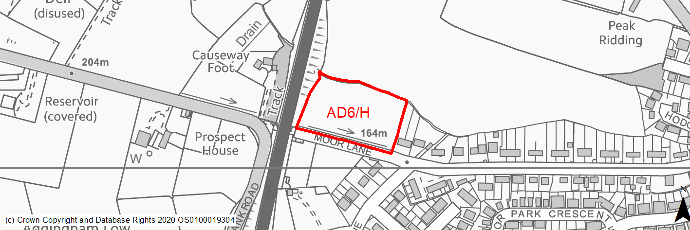
Site location
Local Service Centre -Addingham
Ward
Craven Ward
Site description
The site consists of level grazing land adjacent to urban edge with mature trees/hedgerows and low drystone wall along the boundaries.
Proposed Allocation
Housing
SHLAA referencce
AD/012
Indicative no. dwellings
24
Site area (Gross) (ha)
0.95
Ownership
Private
Delivery timescales
Deliverable/Developable (0-10 years)
Type (PDL/Greenfield)
Greenfield
Green Belt
Yes
Flood Zone
Flood Zone 1
Potential site access
Access to the site is available via the existing field access from Moor Lane, which is unadopted and would need improvement.
Public Transport Accessibility
Bus: Only part of site within 400m of a bus stop with two services every hour.
Rail: the nearest railway station is Ilkley (approx 5.5km to the south east), which is beyond 800m distance from the site.
Sustainability Appraisal
There are unlikely to be any significant effects, either positive or negative, on any SA Objective arising as a result of development at this site.
Minor positive effects were predicted for a range of socio-economic themed SA Objectives due to the benefits of new residential development for the local economy as well as the location of the site in relation to transport links, health facilities and employment areas. However, access to both primary and secondary schools is somewhat limited due to the distances involved and residents may need to travel up to 1.4km to access services and amenities, which is significantly beyond the target distance.
Minor adverse effects have been predicted for a range of natural environment themed SA Objectives, primarily as a result of the impacts of new development on a 100% greenfield and Green Belt site. There is a small waterbody adjacent to the eastern perimeter, the water quality of which could be affected by the development. 60m west of the site are two Grade II Listed Buildings; development at this site could adversely alter the setting of these sensitive heritage assets.
Habitats Regulations Assessment
This site falls within 2.5km of the South Pennine Moors SPA/SAC a HRA must be undertaken to ensure there are no significant effects on these protected sites in terms of impact on supporting habitat which might be functionally linked to the SPA and recreational pressures. Developments within these zones must comply with Policy SP11; an SPD is being produced to provide further guidance.
Green Belt
Based on planning judgement the site has a moderate potential impact on the Green Belt.
• The site is located in a low Green Belt parcel.
• The site makes a moderate contribution to the purposes of including land in the Green Belt.
• The site has moderate potential for sprawl and would have a major impact on openness.
Constraints and Opportunities
• The site is located within the 2.5km buffer of the SPA/SAC.
• Mature trees and traditional stone wall along boundaries.
• Moor Lane requires improvement.
• Site adjacent Green Infrastructure link along Turner Lane.
• Key views through site into wider landscape.
Development considerations
• Ecological surveys to identify any impacts and mitigate accordingly.
• SPA/SAC Zone B - habitat mitigation required.
• Sensitive site design to mitigate any impact on landscape character and retain and enhance key views.
• Boundary trees and traditional stone wall contribute to local character and should be retained and enahnced.
• Provision of new vehicular access from Moor Lane and associated improvements to Moor Lane needed.
• Compensatory Green Belt enhancement required.
Conclusion/Summary
This is a sustainably located Green Belt site adjoining the settlement boundary, which would deliver an estimated 24 dwellings.
(169) AD7/H - Turner Lane/Silsden Road
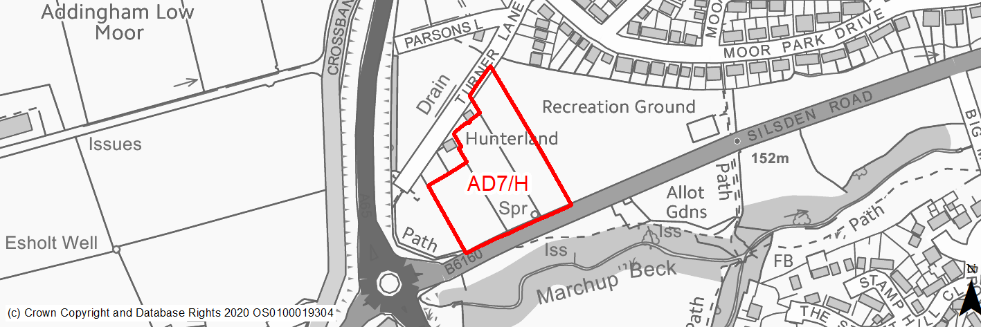
Site location
Local Service Centre -Addingham
Ward
Craven Ward
Site description
This site is made up of a fields used for grazing with mature trees along the boundaries. There are residential uses to the north and recreation uses directly to the east. The boundaries of the site are made up field boundaries in the form of dry stone walls, mature trees and hedgerows.
Proposed Allocation
Housing
SHLAA referencce
AD/020
Indicative no. dwellings
23
Site area (Gross) (ha)
1.37
Ownership
Private
Delivery timescales
Deliverable/Developable (0-10 years)
Type (PDL/Greenfield)
Greenfield
Green Belt
Yes
Flood Zone
Flood Zone 1
Potential site access
The site can be accessed from Silsden Road using existing field access which will need improving. Turner Lane is substandard and will require improving.
Public Transport Accessibility
Bus: Within 400m of a bus stop with two services every hour.
Rail: The nearest railway station is Ilkley (approx 5.5km to the south east), which is beyond 800m distance from the site.
Sustainability Appraisal
Development at this site would be unlikely to result in a significant effect, either positive or negative, on any SA Objective.
Minor positive effects were predicted for a range of socio-economic themed SA Objectives due to the benefits of new residential development for the local economy as well as the location of the site in relation to transport links and health facilities, although access to both primary and secondary schools is somewhat limited due to distance, and residents may find they need to travel up to 1.4km, way beyond the target distance, in order to access services and amenities.
Minor adverse effects were predicted for a range of natural environment themed SA Objectives, largely due to the potential impacts of new development on a greenfield and Green Belt site with adjacent deciduous woodland priority habitat. 50m south of the site is Marchup Beck, the water quality of which could be at risk as a result of the development.
Habitats Regulations Assessment
This site falls within 7km of the South Pennine Moors SPA/SAC. A HRA must be undertaken to ensure there are no significant effects on these protected sites. Developments within these zones must comply with Policy SP11; a SPD is being produced to provide further guidance.
Green Belt
Based on planning judgement the site has a low potential impact on the Green Belt.
• The site is located in a low Green Belt parcel.
• The site makes a moderate contribution to the purposes of including land in the Green Belt.
• The site has a low potential for sprawl and would have a moderate impact on openness.
Constraints and Opportunities
• The site is located within the 2.5km buffer of the SPA/SAC.
• Mature trees and traditional stone wall along boundaries.
• Parsons Lane/Turner Lane requires improvement.
• Site adjacent GI link along Turner Lane and key gateway open space into the village adjacent roundabout.
Development considerations
• Sensitive site design to mitigate any impact on landscape character.
• Boundary trees and traditonal stone wall contribute to local street character and should be retained and enhanced.
• Provision of new vehicular access from Silsden Road Parsons Lane/Turner Lane and associated improvements to Turner Lane needed.
• Retain/enhance area of open space to west of site adjacent roundabout as a wildlife area/SANG.
• Compensatory Green Belt enhancement required.
Conclusion/Summary
This is a sustainably located Green Belt site adjoining the settlement boundary, which would deliver an estimated 23 dwellings.
(65) AD8/H - Church Street/Main Street
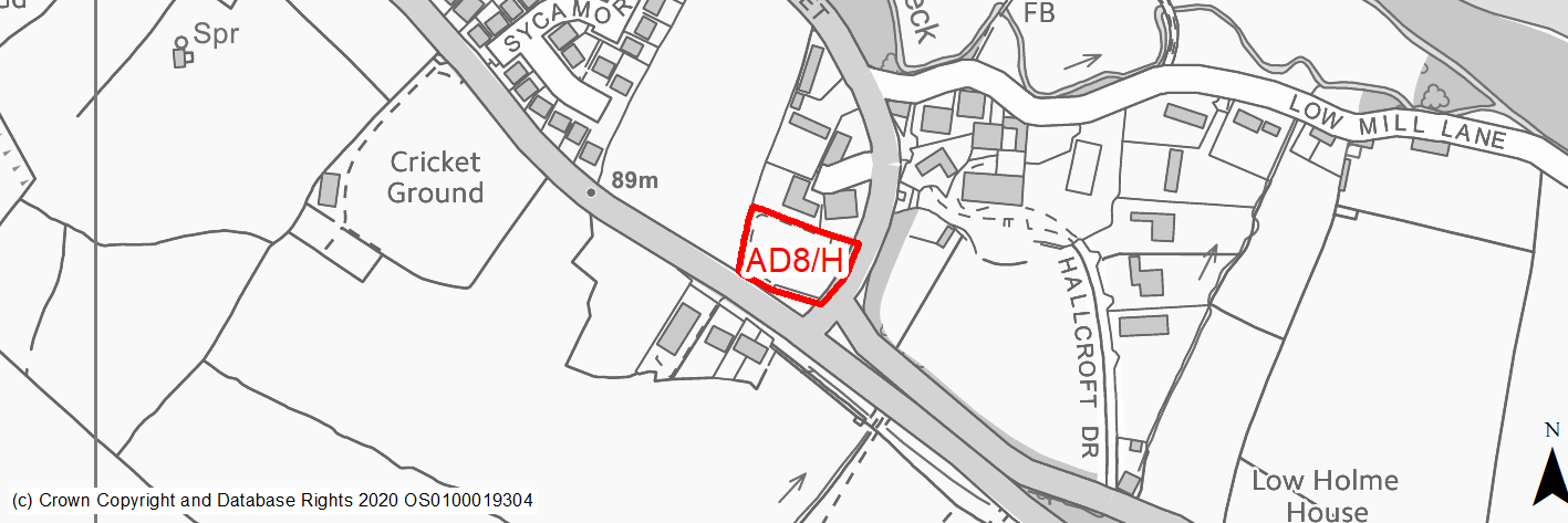
Site location
Local Service Centre -Addingham
Ward
Craven Ward
Site description
Level site used for stone/grit storage, with mature trees and hedgerows along the site's boundaries.
Proposed Allocation
Housing
SHLAA referencce
AD/022
Indicative no. dwellings
8
Site area (Gross) (ha)
0.24
Ownership
Council
Delivery timescales
Deliverable (0-5 years)
Type (PDL/Greenfield)
PDL
Green Belt
No
Flood Zone
Flood Zone 1 and 2
Potential site access
Access to the site is available via the existing access from Church Street, which would need improvement.
Public Transport Accessibility
Bus: Within 400m of a bus stop with two services every hour.
Rail: the nearest railway station is Ilkley (approx 4.5km to the south east), which is beyond 800m distance from the site.
Sustainability Appraisal
No significant adverse effects predicted for the site. Minor adverse effects predicted for air quality and water resources due to increases in pollution and water consumption (as predicted for nearly all other sites). Site is in Flood Zone 2.
This PDL plot would likely be an opportunity to achieve biodiversity net gains and improvements to the local character and setting. The site is well situated to provide residents with good access to key services and amenities, including shops, cultural spaces, jobs and schools, with particularly good access to health facilities.
Habitats Regulations Assessment
This site falls within 2.5km of the South Pennine Moors SPA/SAC a HRA must be undertaken to ensure there are no significant effects on these protected sites in terms of impact on supporting habitat which might be functionally linked to the SPA and recreational pressures. Developments within these zones must comply with Policy SP11; an SPD is being produced to provide further guidance.
Green Belt
N/A – Site not within in the Green Belt.
Constraints and Opportunities
• Part of the site is within flood zone 2 to the south.
• Potential impact on the Addingham Conservation area and landscape as a prominant gateway site into the village.
• The site is located within the 7km buffer of the SPA/SAC.
• Mature trees and potential ecological constraints.
• Council owned site opportunity for self build.
Development considerations
• Ecological surveys to identify any impacts and mitigate accordingly.
• SPA/SAC Zone C - habitat mitigation required.
• Sensitive site design to mitigate any impact on the conservation area.
• Frontage trees contribute to local street character at important gateway into village and should be retained.
• SFRA L2/FRA and mitigation of flood risk issues.
• Vehicular and pedestrian access off Church Street using existing access.
Conclusion/Summary
This is a sustainably located brownfield site within the settlement boundary, which would deliver an estimated 8 dwellings and enhance a prominent gateway site into the village.