
Draft Bradford District Local Plan - Preferred Options (Regulation 18) February 2021
4.0 Thematic Policies
4.0.1 This section of the plan is concerned with a wide range of thematic policies which build upon the strategic priorities and policies set out in section three of the plan. The plan includes a fairly extensive update and refresh to the thematic policies first reviewed as part of the Core Strategy Partial Review in 2019 and extends the range of policies to reflect a move to a single plan format.
4.0.2 The main purpose of many of the policies in this section of the plan is to provide a local policy context to assist with effectively determining planning applications.
4.0.3 The key policy areas covered in this section of the plan follow the overall format of the plan and include:
- employment land and site strategy, employment zones, local skills / training and retail and leisure;
- transport planning, including key delivery projects, the relationship between transport and the environment, development and tourism together with policies on parking, freight and aircraft safety;
- housing delivery, density, standards and types as well as affordable housing, plus a range of specialist housing and accommodation policies and overcrowding and empty homes;
- environment policies covering a wide range of topics, including green infrastructure, biodiversity / geodiversity and trees, historic environment, landscape, countryside, flood risk, air quality, environmental protection, energy, minerals and waste;
- community policies concerned with open space, sport and recreation, local facilities and managing the impact of development on the health of communities;
- design and practical policies to achieve better design, working with landscape and urban character and quality design in relation to streets, movement and safe and inclusive places.
4.0.4 The policies set out in this section should be read with the plan as a whole and in particular with section three (strategic policies) and where relevant the implementation, delivery and monitoring policies under section six.
List of policies:
- Policy EC1: Employment Land Delivery and Strategic Sites
- Policy EC2: Enterprise, Business and Employment Zones
- Policy EC3: Employment and Skills Delivery
- Policy EC4: City, Town, District and Local Centres
- Policy TR1: Strategic Transport Delivery
- Policy TR2: Transport and Environment
- Policy TR3: Integrating Sustainable Transport and Development
- Policy TR4: Transport and Tourism
- Policy TR5: Parking
- Policy TR6: Freight
- Policy TR7: Aircraft Safety
- Policy HO1: Housing Delivery, Strategic Sites and Managing Growth
- Policy HO2: Housing Density
- Policy HO3: Urban Housing
- Policy HO4: Housing Mix
- Policy HO5: Affordable Housing
- Policy HO6: Self-build & Custom Housebuilding
- Policy HO7 Specialist Housing and Accommodation
- Policy HO8: Sites for Gypsies, Travellers and Travelling Showpeople
- Policy HO9: Housing Standards
- Policy HO10: Overcrowding and Empty Homes
- EN1: Green Infrastructure Standards
- Policy EN2: Biodiversity and Geodiversity
- Policy EN3: Trees and Woodlands
- Policy EN4: Historic Environment
- Policy EN5: Landscape
- Policy EN6: Countryside and Development
- Policy EN7: Flood Risk
- Policy EN8: Air Quality
- Policy EN9: Environmental Protection
- Policy EN10: Energy
- Policy EN11: Minerals Supply and Landbanks
- Policy EN12: Mineral Allocations
- Policy EN13: Minerals Safeguarding
- Policy EN14: Minerals Area of Search
- Policy EN15: Managing Development of Minerals Sites
- Policy EN16: Mineral Site Restoration and Aftercare
- Policy EN17: Energy Minerals
- Policy EN18: Waste Management Development
- Policy EN19: Waste Management Allocations
- Policy EN20: Safeguarding Waste Management Facilities
- Policy EN21: Waste Management within Development
- Policy CO1: Open Spaces, Sport and Recreation
- Policy CO2: Community and Health Facilities
- Policy CO3: Health Impact Assessments
- Policy DS1: Achieving Good Design
- Policy DS2: Working with the Landscape
- Policy DS3: Urban Character
- Policy DS4: Streets and Movement
- Policy DS5: Safe and Inclusive Places
4.1 Planning for Prosperity
Growing our Economy and Businesses
4.1.1 There are strong ambitions through the Bradford Economic Strategy and a move to a greener growth strategy for the District to be the fastest growing economy in the UK and this requires the right planning framework to support this ambition. As with all parts of the country Bradford has witnessed significant economic challenges through the impact of the pandemic and a previous period of investment uncertainty due to Brexit. The focus within this section of the plan is to support economic recovery and clearly set out our economic plan at a practical level for the District.
4.1.2 Strategic Policy SP6 provides the overall economic framework for the plan which also links back to strategic objectives within section 2. Work on the employment land forecasting indicates a minimum employment land requirement of 72ha which is anchored within SP6 together with employment land supply ambitions of circa 82ha over the plan period.
Policy Overview
4.1.3 Policy EC1 focuses upon delivering a clear employment land strategy which shadows the approach taken to housing delivery and growth through a focus upon maximising our existing assets and setting out strategic growth ambitions. Policy EC2 provides further policy direction for the development and delivery of employment and business zones within the District as part of this overall employment land strategy.
4.1.4 Tackling the deep seated challenges within parts of the District of economic inactivity, unemployment and skills and qualifications gaps remains a key local priority as part of the District economic and recovery strategy. There is much than planning can do to connect deprived communities to employment and skills opportunities while supporting practical development and these priorities are detailed within Policy EC3.
4.1.5 The role and performance of the City, District, Town and Local Centres is important to a prosperous District. Town centres are at the heart of their communities and are a focus for economic activity including retail, leisure, residential and community provision with accessible public transport connections. The global pandemic has reinforced the importance of local shops and services at the heart of our communities and Policy EC4 continues to support a strong role for maintaining and supporting our vibrant centres.
4.2 Preferred Option – EC1: Employment Land Delivery and Strategic Sites
Introduction
4.2.1 The local economy largely comprises of small enterprises although the District is home to a number of large businesses with recognised brands operating on an international scale. It is also home to successful creative, cultural and tourism based enterprises attracting a large visitor economy. The make-up of the District's employment areas generally consists of established employment locations where existing businesses and industrial uses predominate and other areas in which employment uses are integrated within residential and other uses within large built up areas of the District's urban fabric.
Employment Land Challenges
4.2.2 Over the years a complex mixture of factors including an ageing industrial stock, the changing nature of the economy and business requirements combined with the pressure to accommodate new housing growth and historically the difference in the value of housing land comparative to employment land this has facilitated an erosion of parts of the District's employment land base.
4.2.3 It is also recognised through the work undertaken as part of the Employment Needs Assessment and Land Review (ENALR) and feedback from business stakeholders that:
- the existing office building stock is of particularly poor quality across the District;
- there is an overall declining supply of industrial space within the District and evidence of latent business demand for employment land, and
- there is evidence of a lack of business space opportunities to move within the District to new space as part of medium / larger business expansion which consequently in turn facilitates churn within the lower end of the employment space market for smaller and medium sized businesses to move or expand.
4.2.4 In general terms the employment land evidence indicates a lack of suitable industrial supply in the right locations has cumulated in a shortage of modern quality space to meet requirements.
4.2.5 The market intelligence work by Aspinall Verdi as part of the ENALR indicates that there is particular locational demand 'hotspots' for good quality employment space towards the north / north east of the Regional City of Bradford, south / south east Bradford and Keighley. There are also particular demands for employment space within the Wharfedale Valley. Demand to the west of the regional city is considered weaker with less swift road access to employment sites.
Employment Land Need and Supply
4.2.6 The ENALR (2019) was originally undertaken to inform the Council's preparation of policies for the CSPR to ultimately support the economy and help identify site allocations. Since that time there have been important changes in the economic environment and further work has been undertaken as part of the new Local Plan. This work undertaken by Edge Economics supplements the evidence originally produced and provides an analysis of future scenarios for employment growth along with associated employment land requirement.[1]
4.2.7 The updated evidence informing Policy SP6 using the latest REM forecast (August 2020) is considered to act as the strongest guide for total gross employment land requirement and results in a requirement for circa 72ha (an annual average of +4ha) for B2, B8 and E(g) uses over the lifespan of the plan. This is slight increase from the employment land need position of 70ha (60ha industrial and 10ha office) as detailed in the ENALR (2019).
4.2.8 The forecast includes an extended plan period (to 2038) and considers the implications of the pandemic, which is modelled on the basis of a 'delayed v-shape' recovery. In establishing the employment land requirement, a buffer of 50% has been used to provide for any potential margin of error associated with the forecasting process; a choice of sites to facilitate competition and market choice and allow for flexibilities and delays in individual sites coming forward. It is clear that economic forecasting is very challenging at this time in light of the impact of the pandemic and any longer-term fall out from leaving Europe. Further detail on the analysis undertaken including sensitivity testing is included within Edge Economics report which forms part of the updated evidence base to the plan.
4.2.9 Since the CSPR consultation stage, work has now concluded on the review of employment land supply options within the District. The detailed assessment of all employment sites is included within the Bradford District Sites Assessment Methodology and Report (2021), but in headline terms indicates that there is a non-Green Belt (greenfield and brownfield) open market employment land supply of circa 41ha. A small number of additional non Green Belt (greenfield and brownfield) employment land options have also been identified to directly support current operational businesses of circa 9ha, but not considered part of the overall open market land supply position.
4.2.10 It is clear at a strategic level from the employment land supply position within the District that there is insufficient non Green Belt land to meet the employment land need, leaving a gap of circa 30ha. If the District is to meet its employment land need position in full and continue to sustain economic growth through the plan period, then there is a need to allocate Green Belt land for employment growth to fill this gap. At a strategic level with the shortage of suitable non-Green Belt site options it is considered that there is an exceptional circumstances case for the release of Green Belt land to meet employment land needs. To date no neighbouring authorities have come forward through Duty to Cooperate discussions to take any of the District's employment land need outside the confines of the Green Belt.
4.2.11 In alignment with the Green Belt assessment methodology and published technical papers it is also the case that the release of individual Green Belt sites to meet employment needs also needs to be considered within the context of overall location, sustainability considerations, sectoral opportunities and Green Belt mitigation measures. The type and scale of available employment sites within the District is limited. This may hamper indigenous business growth and provides little relocation opportunities to support the growth of key sectors. The quality of sites has also been highlighted as a concern through the market feedback and intelligence work undertaken as part of the ENALR (2019).
Employment Land Strategy and Preferred Sites Options
4.2.12 The review of the employment land database has indicated that there are still employment land opportunities around the district's core economic areas to stimulate further investment. In addition to the enterprise, business and employment zones detailed under Policy EC2 there are opportunities to cluster smaller scale brownfield regeneration sites within and around zonal areas to maximise opportunities and diversify employment space.
4.2.13 Small employment sites have played a historic role within the Bradford District economy of supplying affordable workspace within the urban environment – often within and connected to housing areas. The local plan continues to recognise the important role that micro and small sites can play in supporting economic growth with a limited portfolio of sites identified. Many smaller employment sites however also often require remediation and infrastructure improvements to improve their market attractiveness The site threshold defined for employment site allocations is 0.25ha (or 500 square metres of floorspace) and above, which aligns with national planning guidance.
4.2.14 Bradford South East is dominated by the M606 logistics and employment corridor. Beyond the zonal areas detailed in Policy EC2 new employment land options are limited. Where there are remaining possibilities these have been considered as part of the overall strategy.
4.2.15 Airedale's site option mix (around Keighley primarily) has yielded a more limited range of deliverable site options than first considered as part of the CSPR – due in the main due to environmental constraints and alternative uses. The employment land focus as with other parts of the district remains connected to existing employment areas and estates plus key transport corridors.
4.2.16 The review of site options submitted through the call for sites in relation to the Wharfedale corridor has not yielded to date any suitably scaled and appropriately located employment site options which could be accommodated within the landscape and character constraints of the sub-area.
4.2.17 Table 4.2 below sets out an overview of non-Green Belt open market employment sites according to location and size and is benchmarked against the CSPR policy aspirations as detailed in the final column of the table. It clearly illustrates the limited range of sites and dominance of smaller sites within the overall portfolio.
4.2.18 With a site portfolio generally consisting of individual sites under 5ha it presents very limited opportunities for 'second move space' or opportunities for expanding businesses to relocate within the district to retain staff and skills. Beyond the identified zonal sites detailed under EC2 there is little in the way of large or strategic scale sites to assist with attracting new growth into the district or further diversifying the economy within key high performance growth sectors.
Table 4.2: Non Green Belt Employment Site Mix (All Types – Open Market)
|
Location |
Micro (0.25-0.99ha) |
Small (1.00-2.49ha) |
Small to Medium (2.50-4.99ha) |
Medium (5.00-9.99ha) |
Large (10-19.99ha |
Strategic (20ha+) |
Area Total (ha) |
CSPR Position (Industrial) (ha) |
|
Regional City |
4 (2.0) |
5 (7.6) |
3 (11.02) |
2 (15.67) |
36.29 |
40 |
||
|
Airedale |
1 (0.8) |
1 (1.18) |
1 (3.30) |
5.28 |
15 |
|||
|
Wharfedale |
5 |
|||||||
|
Total ha |
2.8 |
8.78 |
14.32 |
15.67 |
41.57 |
60 |
||
|
Total (number of sites) |
5 |
6 |
4 |
2 |
0 |
0 |
17 |
4.2.19 Research on the property and land market as part of the ENALR (2019) draws similar conclusions - there is a need for a step change in the scale and quality of employment space within the district to support economic ambitions and jobs growth. This conclusion is also supported by a number of representations made through the CSPR identifying the constraints and barriers to local economic growth.
4.2.20 In order to meet employment land needs and deliver more scale and quality there is a need to consider growth outside the limited stock of brownfield / greenfield sites. In practical terms this means identifying land with the Green Belt for employment land and jobs growth. The exceptional circumstances case for Green Belt release is also explored further under Policy SP5.
4.2.21 A review of candidate sites has been undertaken as part of the employment site assessments which has concluded two major Green Belt located growth opportunities areas:
- Land north of Westgate Hill Street - near an established employment zone and within a major transport corridor. The site is connected to a wider strategic growth area for housing and infrastructure improvements to the east of Holme Wood. As a key gateway site to the city this site presents opportunities to deliver high quality employment space within close proximity to the city edge and areas of high deprivation.
- Apperley Bridge / Esholt Strategic Employment Area – broad area currently identified in adopted Core Strategy and primarily associated with a redundant brownfield site. This site offers potential for major economic transformation and due to the character of the site and locational opportunities could assist with attracting science, high technology and green economy orientated businesses.
Both sites need to come forward as part of comprehensive masterplans. Further site details and local strategies for these areas are also contained within Section 5 of the Local Plan.
4.2.22 In additional to 'open market' land supply a small number of sites have also been identified which are considered suitable for business specific uses due to their proximity to existing businesses and various site constraints. These sites are also included within the policy.
4.2.23 While often overlooked in the initial planning of employment sites there is a need to ensure regardless of location that all employment land come well served with digital infrastructure as part of the utilities planning stage of development.
Policy EC1: Employment Land Delivery and Strategic Sites
- To meet the employment land need as set out in Policy SC6 and deliver economic growth and support jobs within the District, sustainable economic growth is directed towards the employment land sites as identified on the Policies Map for Class B2 (General Industrial), Class B8 (Storage and Distribution) and Class E (g) and further detailed in section 5 of the Local Plan in employment site pro formas.
- The Regional City of Bradford will support economic growth through:
- Allocation of employment land sites concentrated and clustered within or close proximity to Enterprise Zones, Business Development Zones and Employment Zones (Policy EC2) as set out on the Policies Map, Section 5 of the plan in detail and listed below:
NE24/E – Land at Gain Lane and Woodhall Road – 9.85ha
SE32/E – Euroway Trading Estate, Commondale Way – 0.51ha
SE33/E – Land to the East of Laisterdyke and south of Leeds Road – 1.99ha
SE34/E – Land East of Sticker Lane – 1.35ha
SE35/E – Land adjoining Lower Lane, Parry Lane and Sticker Lane – 1.19ha
SE36/E – Parry Lane – 4.90ha
SE39/E – Neville Road / Lower Lane – 1.57ha
SE40/E – Staithgate Lane North – 5.82ha
SE42/E – Staithgate Lane South – 2.87ha
- Allocation of employment land sites supporting the further diversification of employment space within the Bradford Urban area and established employment zones (Policy EC2) as set out on the Policies Map, Section 5 of the plan in detail and listed below:
SE41/E – Westgate Hill Street – 1.50ha
SE43/E – Dick Lane – 0.55ha
SE44/E – Shetcliffe Lane – 0.42ha
SW47/E – Between Clayton Land and Lister Arms, Manchester Road – 0.52ha
SW48/E – Ingleby Road – 3.25ha
- The development of a strategic employment site as set out on the Policies Map and Section 5 of the plan in detail within Bradford South East at SE37/E – North of Westgate Hill Street (9.06ha) as part of the Tong Street / Westgate Hill Street masterplan and growth area. As a key gateway location development should come forward to deliver premium quality employment space as part of a comprehensive strategy with housing sites SE19/E, SE46/H, SE47/H and SE48/H.
- The Airedale Sub Area will continue to support economic growth through:
- The allocation of land as set out on the Policies Map and section 5 of the plan in detail within Keighley Business Development Zone at KY49/E – Beechcliffe – 3.30ha.
- Allocation of employment land within the Bingley ad Keighley transport corridor as set out in the Policies Map and within section 5 of the plan in detail and listed below:
KY50/E – Bradford Road – 0.80ha
BI9/E – Castlefields Road – 1.18ha
- Apperley Bridge / Esholt – Strategic Employment Area
- The allocation of employment land on the Policies Map and set out in detail within Section 5 of the plan, and listed below:
NE22/E – Walkhill Farm, Apperley Lane – 4.94ha
NE/23E – Apperley Bridge / Esholt (Former Filter Beds – Water Treatment Works) – 26.61ha (net developable area).
- NE/23E is allocated for up to 100,000 sqm of employment space and Use Classes B2/B8/E(g) and Ancillary E (A1,A3,D1 D2), Sui generis (A5).
- The Strategic Employment Area as allocated is of regional importance for supporting the growth of the green economy and the growth of science, technology and supporting businesses and will be underpinned by a comprehensive spatial framework and masterplan together with infrastructure, implementation and phasing strategies.
- Due to specific site and operational constraints and to support the expansion of existing businesses additional employment land will be allocated on the Policies Map and set out in detail within Section 5 of the plan, and listed below:
BI10/E – John Escritt Road, Bingley -0.5ha
SE38/E – AH Marks Works, Wyke Lane – 5.42ha
ST5/E – Lyon Road, Steeton – 2.69ha
- Subject to regular review, allocated employment sites will be protected for employment use in order to maintain an adequate and flexible supply of employment land to attract inward investment, to enable existing businesses to grow and to create new and retain existing jobs.
- Digital infrastructure should be included within early stage utilities planning and delivery for allocated employment sites.
Reasonable Alternatives - EC1: Employment Land Delivery and Strategic Sites
4.2.24 The key reasonable alternatives considered in drafting this policy include:
- Splitting the policy into two and developing non-strategic and strategic employment land policies – generally easier to find and reference within single policy structure.
- Keeping a 'looser' policy structure and listing sites in a table (in policy or referenced outside) – preferred option includes site listing within a delivery strategy or framework with further referencing and detail available within section 5 of the plan.
(10) Consultation Question 18
EC1: Employment Land Delivery and Strategic Sites
This policy provides a framework for the allocation of employment land within the District – maximising urban employment options and setting out new strategic growth opportunities.
Q18. Please provide your comments for Policy EC1 and any suggested changes to the policy? If you would support an alternative to the preferred option, please provide further details and evidence to support this.
4.3 Preferred Option – EC2: Enterprise, Business and Employment Zones
Introduction
4.3.1 As part of the overall economic and growth strategy for the District to address some of the employment space challenges, the Council is working with stakeholders and businesses to establish a series of enterprise and business development zones to unlock and support improvements to the employment land portfolio within the District.
Enterprise Zones (EZs)
4.3.2 The Bradford District Enterprise Zones (EZs) consist of three major sites – Staithgate Lane, Parry Lane and Gain Lane all within the Bradford area and part of a much wider programme across the Leeds City Region and embedded within the Leeds City Region Strategic Economic Plan to provide high standard premises for expanding businesses or to attract inward investment. The particular economic focus for the enterprise zones within Bradford embedded is to promote advanced manufacturing growth, building upon the regions strong manufacturing heritage.
Business Development Zones (BDZs)
4.3.3 Within the District four areas have been identified for Business Development Zones (BDZs) namely:
- Bowling Back Lane, Bradford;
- Shipley from Saltaire to Dockfield Road;
- Dalton Lane, Keighley, and
- Royds Ings, Keighley
4.3.4 All the areas identified have a long history of employment related uses and industry and the purpose of the BDZs is to bring forward the regeneration of redundant land and premises, together with general improvements to the physical environment. The BDZs also provide a strategic set of locations for funding.
Employment Zones
4.3.5 The Council is also keen to maintain a strong range of traditional employment zones in urban areas within which existing business and industrial uses tend to predominate. In these areas employment uses will continue to play an important role in providing jobs for local communities. As part of the wider site allocation work programme, a number of these areas have been provisionally reviewed during the site allocation process in consideration of:
- uses approved through planning applications;
- their changing uses and character since first designated, and
- the overall strategy and ambitions within the plan.
Initial findings only are presented at this stage with further detailed assessment required to inform further plan-making. The employment zones within the District are more extensive than the enterprise and business development zones but there is a strong synergy between the zones.
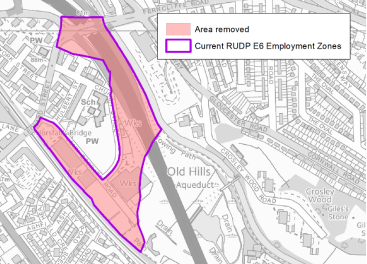
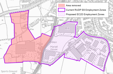
4.3.6 The main physical boundary changes to the employment zones are set out below in Table 4.4 and includes revisions to Silsden (South); Canal Road Corridor, and generally minor changes to the boundaries of the zones in South East and South West Bradford to rationalise land uses. More significantly, the removal of Bingley as substantially now developed for road infrastructure, and the removal of parts of Bowling is made to facilitate an extended city centre boundary and proposed new Southern Gateway regeneration area. Proposed changes within Bradford City are set out in detail within Section 5 of the local plan, but a greater diversification of uses is planned for the new extended Southern Gateway area to maximise growth opportunities within close proximity to potential transport investment (NPR Station) while also maintaining a clear business and enterprise focus within the overall gateway area.
4.3.7 Within the redefined Employment Zones it will be important to maintain and encourage new industrial and commercial investment, with proposals to erode the employment character and function of the areas resisted.
Table 4.3: Employment Zones and Changes
|
Sub Areas and Settlements |
Employment Zone (with RUDP Reference) |
Changes Proposed |
|
Regional City of Bradford |
||
|
Canal Road |
Canal Road (BN/E6.2) – reflective of wider Area Action Plan considerations |
|
|
Bradford South East |
Euroway Estate / M606 Corridor (BS/E6.2) |
No major changes proposed |
|
Staygate / Eurocam (BS/E6.7) |
No major changes proposed |
|
|
Low Moor (BS/E6.3) |
No major changes proposed |
|
|
Tong Street / Shetcliffe Lane (BS/E6.5) |
No major changes proposed |
|
|
Law Street / Dudley Hill (BS/E6.4) – boundary change in consideration of preferred option housing allocation |
|
|
|
Cutler Heights (BS/E6.8 and BN/E6.4) |
No major changes proposed |
|
|
Bowling (BN/E6.1) – expansion of city centre and new Southern Gateway. BDZ and employment zone to be retained to the east and extreme south |
|
|
|
Bradford South West |
Paradise Green (BS/E6.1) |
No major changes proposed |
|
Thornton Road (BW/E6.2) – adjustment to south west area in consideration of more mixed use character |
|
|
|
Shipley |
Shipley (S/E6.3) |
No major changes proposed |
|
Airedale |
||
|
Bingley |
Bingley (S/E6.1) - Site removed as substantially developed for road infrastructure (A650). |
|
|
Crossflats (S/E6.2) |
No major changes proposed |
|
|
Keighley |
Worth Village (K/E6.3) |
No major changes proposed |
|
Hard Ings / Beechcliffe (K/E6.2) |
No major changes proposed |
|
|
Silsden |
Keighley Road (K/E6.1) – changes reflective of housing uses. |
|
Policy EC2: Enterprise, Business and Employment Zones
- The development, regeneration and protection of employment areas for B-class uses within the District will be supported to meet the needs of the market and provide land to support jobs and economic growth.
- Enterprise Zones (EZs) are designated on the Policies Map to provide high standard premises for businesses and attract inward investment, at:
- Staithgate Lane
- Parry Lane
- Gain Lane
- Business Development Zones (BDZs) are designated on the Policies Map to support the regeneration of established employment areas at:
- Bowling Back Lane, Bradford
- Shipley from Saltaire to Dockfield Road
- Dalton Lane, Keighley
- Royds Ings, Keighley
- Employment Zones (EZs) within the District are designated on the Policies Map to maintain and support local business growth and development within:
- Regional City of Bradford – Canal Road, Euroway Estate, Staygate / Eurocam, Low Moor, Tong Street / Shetcliffe Lane, Law Street / Dudley Hill, Cutler Heights, Bowling, Paradise Green, Thornton Road, and Shipley.
- Airedale sub area – Crossflats, Worth Village, Hard Ings / Beechcliffe, and Keighley Road.
- Investment in high capacity digital infrastructure will be supported within the designated zones to support economic growth and build business capacity.
- Small-scale proposals (up to 100 sqm of floorspace) for changes of use or redevelopment to non-B-class employment uses within Enterprise, Business and Employment Zones will be supported where they would provide complementary use(s) that are not detrimental to the function and operation of the zones.
- The change of use or redevelopment of land and buildings over 1000 sqm of floorspace or 0.5ha in B-class employment use to non-B-class uses within the defined zones detailed above will only be permitted where it can be demonstrated that:
- There are strong economic and employment reasons why the proposed development would be acceptable.
- Market intelligence indicates that the premises / site are unlikely to come back into B-class employment use.
- The proposal would not be detrimental to the function and operation of the wider zone; and/or
- The continued use of the site in its present use or any B-class use is not appropriate due to a significant detrimental impact on residential amenity or the environment.
Reasonable Alternatives - EC2: Enterprise, Business and Employment Zones
4.3.8 Reasonable alternatives considered include:
- Individual policies for each type of zone – not as simple a policy layout as a single policy format.
- Combine zonal areas – while in some cases there is a lot of geographical cross-over between the zones their functions differ and multiple zone listing allows for a diverse approach to business retention, regeneration and inward investment.
- Combine employment site and zonal policy – single policy approach considered too complex.
- Remove threshold levels and criteria for change of use – policy introduces a degree of flexibility but also a clear focus upon protecting employment uses and activities.
(5) Consultation Question 19
EC2: Enterprise, Business and Employment Zones
The policy designates and protects employment orientated zones across the district and introduces thresholds for alternative redevelopment or change of uses.
Q19. Please provide your comments for Policy EC2 and any suggested changes to the policy? If you would support an alternative to the preferred option, please provide further details and evidence to support this.
4.4 Preferred Option – EC3: Employment and Skills Delivery
Introduction – Overview
4.4.1 Based upon ONS mid-year estimates (2019) the District has a total population of 539,775 with 330,965 people of working age (16-64 years). The percentage of working age population is lower at 61.3% than the West Yorkshire average of 62.8%. In line with other commentary the Bradford District has a higher percentage of 0-15 years at 23.7% (or 127,915 people) compared to the West Yorkshire average of 20.6%.
4.4.2 Economic activity rates for the age group 16-74 years indicates about a third of the referenced population group is economically inactive - circa 122,490 people (this excludes economically active unemployed people and full time students). This is above the West Yorkshire average (31.5%). The figures do include people 65-74 and may be reflective also of child and other care responsibilities within families – particularly members of the BAME communities.
4.4.3 Business Register and Employment Survey (BRES) data for estimates of workforce jobs in Bradford by industry groups indicates that the health sector is the largest industry sector at 15.6% of all people in employment, followed by manufacturing at 13.2% and education at 11.2%. Workforce jobs is based upon place of work not residence of the worker. Not surprisingly, the survey data also indicates that Bradford has a higher percentage of public sector jobs at 21.8% compared with the sub-regional average of 17.8% and national (England) average of 15.8%. Jobs in the private sector as a percentage is consequently lower.
4.4.4 Information on 'jobs density' or the number of jobs as a percentage of working age population is significantly lower in Bradford District at 62.6% compared to the West Yorkshire figure of 73.9% and national (England) figure of 76.3%.
Local Residents – Employment, Qualifications and Skills
4.4.5 The employment sectors of Bradford District residents indicate that the largest employment sector is retail, followed by health and social work and thirdly by manufacturing. In terms of job types people working in managerial, professional and associate professional occupations are lower at 34.9% of people in employment than the West Yorkshire figure of 37.7% and national (England) average of 41.1%. People working in elementary occupations is also slightly above sub-regional and national figures.[2]
4.4.6 Within the Bradford District the number of people on unemployment benefit (job seekers allowance and universal credit) is 31,525, which as a rounded percentage of working age population (9.5%) is above the sub-regional average (7.5%). Youth unemployment (18-24 years) and older unemployment (50 years plus) are both above West Yorkshire percentages.
4.4.7 Qualifications across NVQ equivalent levels 2, 3 and 4+ are lower than the sub- regional average with the proportion of the workforce with no qualifications being approximately about 27.7% of people aged 16-74 years, above West Yorkshire average of 25.9% and England figure of 22.5%.
4.4.8 Potentially reflective of the wider economic picture, annual household income at £36,871 is lower than the West Yorkshire average of £38,499. The Indices of Multiple Deprivation suggests that almost a quarter of a million people in the District are living in the most deprived 20% of areas of England for income deprivation. Similar numbers of people are also in the most deprived 20% of areas, for employment, education, health and living environment domains, with the crime domain at over one third of a million. The connected nature of deprivation and challenges for addressing employment and skills improvements cannot be under-estimated and form an important element of the local plan strategy.
Challenges and Opportunities
4.4.9 For some of Bradford's communities there are deep seated challenges in terms of economic activity and employment, with skills and qualification gaps identified at both the bottom and top of the labour market. It would however, be wrong to paint a negative overall picture of the District and it is clear from the analysis within local areas and neighbourhoods in section 5 of the Local Plan that Bradford's communities are incredibly diverse with many settlements in areas for example such as the Whafedale corridor performing very well in terms of economic, housing and health indicators. The District's diversity and relatively young and enterprising population also brings a certain dynamism to the local economy.
4.4.10 Part of the strategy for a prosperous economy is to create the right conditions and opportunities for significant jobs growth and prioritise the upskilling of the existing working age residents of the District. It is recognised that there are skills mismatches between segments of the working age population and local business demands. The District Workforce Development Plan: People, Skills, Prosperity[3] sets out to ensure local people have the skills that employers need, to improve the quality of jobs in the District and ensure local jobs and careers are available to all communities.
4.4.11 Construction projects including new housing, employment space and infrastructure have their own significant economic multipliers and the potential to support local skills development and traditional and specialist apprenticeships.
4.4.12 Policy EC3 builds upon ideas originally expressed in the CSPR and sets a policy framework through employment and skills plans to link construction projects to local education, training and apprenticeship opportunities, supporting local communities improve economic circumstances and build high quality skills and career paths. Further analysis will be required on threshold testing as part of whole plan viability considerations to support Regulation 19 stage of the plan.
Policy EC3: Employment and Skills Delivery
To support improved local employment and skills delivery, the Council will seek to secure:
- Employment and skills plans for strategic scale infrastructure, housing (400 dwellings plus) and employment projects (5ha plus), with at least 10% of the workforce employed at any one time from the District's 20% most deprived areas, as defined under the Indices of Multiple Deprivation, or similar indices as published from time to time, by Central Government or the Council.
- Local employment and skills plans for the construction phases of residential developments of more than 50 dwellings gross and commercial schemes of more than 1,000 square metres gross.
- Local employment and skills plans for the occupancy phase of commercial developments that are estimated to create more than 50 full time equivalent jobs.
- In instances where the development does not trigger one of the above thresholds then wherever feasible the Council will seek to secure alternative education or training programmes with the applicant to contribute to skills development.
- The extent of local employment and skills plans will be set out through a supplementary planning document and s.106 obligations framework.
Reasonable Alternatives - EC3: Employment and Skills Delivery
4.4.13 Reasonable alternatives considered include:
- No specific policy EC3 and maintain a strategic policy position only within SP6 – would fail in practical policy terms to address key issues.
- Different thresholds with variety of options – thresholds have been set to incentivise local skills and labour opportunities without compromising viability, but further work will be required on viability testing.
- More limited scale policy – policy sections support a comprehensive package of measures.
(3) Consultation Question 20
EC3: Employment and Skills Delivery
Policy detail has been extracted from wider CSPR drafting under policy EC3 and further developed to focus upon a package of skills and employment measures.
Q20 Please provide your comments for Policy EC3 and any suggested changes to the policy? If you would support an alternative to the preferred option, please provide further details and evidence to support this.
4.5 Preferred Option - EC4: City, Town, District and Local Centres
Introduction
4.5.1 The role and performance of the City, District, Town and Local Centres are important to a prosperous District. They are at the heart of their communities and are a focus for economic activity including retail, leisure, residential and community provision with accessible public transport connections. Policy EC4 sets out the network and hierarchy of centres and the role each will play including the type and scales of development appropriate in each centre. Policy EC4 links to Strategic Policies SP2, SP3, SP4 and SP6, and will enhance the role and function of existing and proposed new centres within the City of Bradford, Airedale, Wharfedale and South Pennines. Policy EC4 will ensure that the city centre and principal town centres have a competitive role and function within the Bradford and wider Leeds City Region economy in support of SP6.
4.5.2 The aims of Policy EC4 are to:
- Sustain and enhance the vitality and viability of the District's hierarchy of centres taking a positive approach to their growth, diversification, management and adaptation.
- Encourage variety, choice and quality of retail, commercial, business and leisure provisions in the city and town centres and other district and local centres.
- Ensure access by a choice of means of transport particularly the promotion of walking and cycling, to facilitate combined shopping trips and minimise the need to travel
- Support healthy, competitive, adaptive, innovative and successful town centre provision including community and civic activities.
Retail Hierarchy
4.5.3 The retail hierarchy has been developed using evidence from the Bradford District Retail & Leisure Study (2019). The hierarchy will help to guide new development to appropriately sized centres across the District and ensure that future growth is adequately balanced. It is influenced both by the scale and status of existing centres, and is flexible in allowing centres to grow sustainably where recognised retail needs are demonstrated.
4.5.4 The City, Town, District, and Local Centres within Bradford District in general are performing well in their respective role as main commercial centre for their relevant catchment areas. The Bradford District Retail & Leisure Study (2019) commented that most of the centres have been maintaining good health supported by an appropriate presence of comparison and convenience offer, wide range of non-retail services, balance between independent and multiple stores, strong footfall, accessibility and safety. However, it is also acknowledged that some centres are not performing to their potential. Indicators pointing towards underperforming centres include high vacancy rates, lack of vitality during day/night time, poor built environments and a narrow retail offer, all of which influence how people make choices on where they wish to visit. The priority of the policy therefore is to preserve and enhance the health of these centres, retain and expand the current range of facilities and support businesses to adapt in response to changing economic circumstances.
4.5.5 In line with the National Planning Policy Framework (NPPF) paragraph 85 - 90, Policy EC4 seeks to ensure the continued vitality of town centres beyond just retail. The policy recognises that diversification is key to the long-term vitality and viability of town centres, and to respond to rapid changes in the retail and leisure industries. Accordingly, it aims to clarify the range of uses permitted in such locations allowing a suitable mix of uses (including housing) and reflecting their distinctive characteristics- all as part of taking a positive approach to their growth, diversification, management and adaptation.
Sequential Approach and Assessing Impact
4.5.6 In addition to defining a hierarchy of centres, the policy also outlines the requirements for the sequential approach and sets local thresholds when assessing the impact of planning application for retail and leisure uses in edge of centre or out of centre locations. The Bradford District Retail & Leisure Study (2019) has provided the evidence base for the revised impact assessment criteria under Policy EC4.
4.5.7 It is for the applicant to demonstrate compliance with the sequential test and/or impact test. Failure to undertake a sequential assessment and/or impact assessment could in itself constitute a reason for refusing permission. The sequential test and impact test should be undertaken in a proportionate and locally appropriate way, drawing on and sharing existing information where possible. The applicants and the Council should seek to agree the scope, key impacts for assessment, potential suitability of alternative sites and level of detail required in advance of applications being submitted. The steps taken for applying the impact test are set out within NPPG.
Future Requirements
4.5.8 Supporting existing city and town centres across Bradford District to help grow the local economy in an inclusive, innovative, adaptable and sustainable way is a Council priority as highlighted in the Bradford Council Plan 2021-2025 Policy EC4 will therefore support town centre improvement and regeneration programmes in order to create a prosperous district.
4.5.9 The 2019 study further presents an up to date health check of all the centres and indicates the likely future requirements for additional retail floorspace area in the District. The study highlights there is no quantitative requirement identified for any additional convenience goods floorspace within Bradford District's catchment up to 2034 once existing commitments are considered. In terms of comparison goods floorspace requirements, again based on a constant market share across Bradford District, it has been identified that by 2029, there will be 10,300 sqm of comparison goods floorspace required, increasing to 13,100 sqm by 2030.
4.5.10 The Council will continue to assess the retail and commercial leisure needs and capacity of the District and will take a proactive approach in relation to any future opportunities that may arise for new comparison and convenience retail developments, based on the location of such proposals, and the qualitative and economic benefits which occur from development.
Challenges and Opportunities
4.5.11 The pandemic is having a significant impact on the local economy and employment, and it is not yet known when this will end or what will be the exact nature of the economic recovery – the updated economic forecasts use a delayed 'v curve' but much could change. There are a range of predictions as to how Covid19 will change the supply and demand for retail, businesses and other commercial spaces. It is also uncertain which of these will become a longer term reality and which might fall away as the economy starts to recover from the impacts of the pandemic. Following the Covid-19 crisis there is likely to be a spike in town centre vacancies with unfortunately some businesses failing to re-open. Many operators have already announced job losses and store closures in the district.
4.5.12 The pandemic has more positively also highlighted the importance of local shops and facilities within walking and cycling distance of where people live and work, as essential to many communities. The continued move towards online sales amplified through the pandemic has also presented new business opportunities within local communities for businesses who have been quick to adapt to the challenging trading conditions with click and collect and delivery services. The Local Plan continues to plan for economic growth though policies which should help create positive conditions for trading across the District's diverse network of centres in which businesses can invest, expand and adapt.
4.5.13 The recent restructure and amendment to the Use Class Order in 2020, especially the introduction of Use Class E, has offered greater flexibility for the occupational mix of the town centres in order to respond more quickly to the unprecedented and unpredictable changes in occupational demand. The substantial amount of space potentially in play indicates a major possible scale of change in the make-up of the District's high streets and town centres. Although the extent to which this occurs will depend on the market and how the current uncertainties play out, Policy EC4 will seek to continue strengthening the role of each centre as a desirable place to visit, shop, live work and participate in social and cultural activities. The approach taken should allow each centre to build on its strengths, counter any weaknesses and address the challenges of the future.
4.5.14 The Council recognises that there is scope to diversify the city and town centres and improve the evening economy through the promotion and enhancement of commercial leisure and cultural facilities which will complement the role and function of city and town centres. There are opportunities to improve the quality and the range of restaurants, bars, public houses and evening entertainment uses within the city and town centres.
Policy EC4: City, Town, District and Local Centres
Planning decisions, plans, town centre strategies, investment decisions and programmes should seek to sustain and enhance the vitality and viability of a network and hierarchy of centres in the Bradford District by ensuring that new, appropriate scale of retail, leisure and office development is encouraged in sequentially preferable locations.
- Bradford City Centre should be the focus for a wide diversity of economic activity, including significant offices, residential, convenience and comparison retail including the traditional (and specialist) markets, leisure, entertainment, arts, culture, tourism, intensive sports and recreation uses and the priority centre for promotional events and activities.
- Keighley, Ilkley, Bingley and Shipley Town Centres should be the focus for office, residential, convenience and comparison retail, including the traditional (and specialist) markets, leisure, entertainment, arts, culture and tourism, intensive sports and recreation uses that are appropriate to the centres, provided proposals do not have a significant adverse impact upon the vitality and viability of Bradford City Centre and other nearby Town Centres.
- The District Centres of Five Lane Ends, Girlington, Great Horton, Greengates, Thornbury, Tong Street, should be the focus for convenience retail and limited comparison retail and a range of non-retail services such as banks, building societies, restaurants, cafes and local public facilities in order to enable people to meet their day to day needs and minimise their need to travel, provided proposals do not have a significant adverse impact upon the vitality and viability of Bradford City Centre and other nearby Town Centres.
- The following 47 Local Centres within urban areas and villages should be the focus for appropriately sized local supermarkets and a variety of small shops of a local nature to meet people's day to day needs and minimise their need to travel.
Addingham, Allerton, Baildon, Bankfoot, Barkerend Road, Bolton Junction, Burley-in-Wharfedale, Carlisle Road/Whetley Hill, Clayton, Cottingley, Crossflatts, Cross Roads (Keighley), Cullingworth, Denholme, Duckworth Lane, Eccleshill, Fell Lane/Oakworth Road (Keighley), Frizinghall, Harden, Haworth (Main Street), Haworth (Mill Hey), Heaton, Holme Wood, Horton Grange, Idle, Laisterdyke, Leeds Road, Lidget Green, Low Moor, Marshfields (Manchester Road), Menston, Oak Lane (Manningham), Oakworth, Princeville, Queensbury, Riddlesden, Saltaire, Silsden, Steeton with Eastburn, Sticker Lane, Thornton, Undercliffe, White Abbey Road, Wibsey, Wilsden, Wrose, Wyke.
- The sequential test will apply to all planning applications for main town centre uses which are neither in an existing centre nor in accordance with the Local Plan. Main town centre uses (as defined in NPPF Annex 2) should be located in centres, then in edge of centre locations and only if suitable sites are not available (or expected to become available within a reasonable period) should out of centre sites be considered. When considering edge of centre and out of centre proposals, preference will be given to accessible sites that are well connected to the centre. Applicants and the Council should demonstrate flexibility on issues such as format and scale. The sequential test will not be applied to applications for small scale rural offices or other small scale rural development.
- When assessing applications for retail, and leisure development not in accordance with the Local Plan and in an edge of centre or out of centre location, the Council will require an impact assessment where:
- The proposal provides greater than 1,500 sqm gross retail and / or leisure floorspace.
- The agreed catchment area of the proposal encompasses Keighley, Ilkley, Shipley, and / or Bingley Town Centre and the proposal provides greater than 1,000 sqm gross retail and / or leisure floorspace.
- The proposal is located within 800 metres of the boundary of the district centre and is greater than 500 sqm gross.
- The proposal is located within 800 metres of the boundary of a Local Centre and is greater than 200 sqm.
- The impact assessment should include an evaluation of:
- The impact of the proposal over time on existing, committed and planned public and private investment in a centre or centres in the catchment area of the proposaland
- The impact of the proposal on town centre vitality and viability, including local consumer choice and trade in the town centre and the wider retail catchment (as applicable to the scale and nature of the scheme).
- The steps taken in applying the impact test should align with current national planning policy guidance or any subsequent change to the guidance.
- Where an application fails to satisfy the sequential test or is likely to have significant adverse impact on one or more of the aboveconsiderations, it should be refused. It is for the applicant to demonstrate compliance with the sequential test and/or impact test. Failure to undertake a sequential assessment and/or impact assessment could in itself constitute a reason for refusing permission. The sequential test and impact test should be undertaken in a proportionate and locally appropriate way, drawing on and sharing existing information where possible. The applicants and the Council should seek to agree the scope, key impacts for assessment, potential suitability of alternative sites and level of detail required in advance of applications being submitted.
- Retail development will only be permitted outside of the Primary Shopping Areas as defined on the Policies Map if the following criteria are satisfied:
- The proposed development is of an appropriate scale;
- There are no alternative central sites within the primary shopping areas which are suitable, and available, with preference then given to expansion areas, edge of centre sites before out-of-centre sites are considered.
- The proposed development will not have a significant adverse impact on the vitality and viability of existing Town, District and Local Centres; and
- The proposed development is accessible to all modes of transport, especially public transport, walking and cycling.
- Proposals for office and other main town centre uses will only be permitted on sites outside the city, town and district centre boundaries (as defined on the Policies Map) if:
- The scale of the proposed development is of an appropriate scale.
- There are no alternative central sites within the city, town or district centre boundaries which are suitable, and available, with preference then given to expansion areas, then edge of centre sites, before out-of-centre sites are considered.
- In the case of main town centre uses, it will not have a significant adverse impact on the vitality and viability of any existing city, town or district centre.
- The proposed development is accessible to all modes of transport, especially public transport, walking and cycling.
- The proposed development would not result in unacceptable highway impacts.
- The development would not undermine the economic development strategy of the Local Plan.
- Small Shop Units (under 150 square metres gross of floor space) within walking distance of most residential properties will be permitted, provided that the development will not lead to the creation of a shop or group of small shops which collectively would have a significant adverse impact on the vitality and viability of the network and hierarchy of City, Town, District and Local Centres.
- Office, residential uses, healthcare, community, educational and cultural facilities and services at ground and upper floor levels within the above centres will be encouraged, provided they do not have a significant adverse impact on the retail function of the Primary Shopping Area.
- Temporary occupation of long-term vacant premises and cleared sites by creative industries and cultural and community organisations will be supported where they contribute to regeneration and enhance the character of the area.
- Development, environmental enhancements, accessibility improvements, town centre management strategies and promotional events and activities should take place in each of the centres within the District to create distinctive, attractive and vibrant sense of place and identity to be enjoyed and used by all.
Reasonable Alternatives - EC4: City, Town, District and Local Centres
4.5.15 The following reasonable alternatives have been considered and discounted:
- No or limited updates from the CSPR – this would not fully reflect the evidence base from the Bradford District Retail and Leisure Study
- A radically reduced in scale policy – may not provide a full policy framework to the District's diverse centre.
- Splitting the policy into individual policies covering specific topic – the single policy approach provides ease of use.
(11) Consultation Question 21
EC4: City, Town, District and Local Centres
Policy details an extensive approach to supporting the role and performance of centres across the district.
Q21 Please provide your comments for Policy EC4 and any suggested changes to the policy? If you would support an alternative to the preferred option, please provide further details and evidence to support this.
4.6 Preferred Option - TR1: Strategic Transport Delivery
4.6.1 The Council is planning a suite of transport schemes for delivery to enable sustainable, inclusive growth that improves the lives of people residing, working and visiting Bradford District. The efficiency of planning transport with respect to the environment is of paramount importance, as detailed in policy TR2. As a consequence, transport policies TR3 and TR6 focus on the need to reduce travel for people and goods, which can be achieved through careful planning, adopting mixed- use developments and incorporating digital solutions.
4.6.2 While reducing the need for travel is a key aspiration, for many people travel is inevitable to access workplaces, education, leisure and other amenities. To manage increasing demand within finite space, energy and environmental constraints, mode shift must be prioritised, with a focus on bettering quality of life. When well planned, travel is an enjoyable experience that contributes to quality of life, with active travel contributing most strongly to this. Those who cycle or walk to work consistently report that their commute is an enriching experience, whereas those who drive to work most consistently regard it as a stressful experience.
4.6.3 The Council is placing a strong focus on providing quality, accessible cycle facilities to facilitate cycling for everyone. These facilities will be designed in accordance with LTN1/20, Manual for Streets 2, (3), and the latest applicable cycle and walking design guidance. In some places, this will require constructing facilities on existing roads, while in others this will involve building new stretches of cycle track with walking potential. Walking is similarly a key focus for more local trips, and is the start and end of every journey. The Council will build on the existing network of public rights of way to create attractive, permeable, experiential pedestrian environments which cement walking as a desirable way to travel.
4.6.4 To meet ambitious climate change commitments and support the energy transition of the transport sector, as well as providing better connectivity for communities in the district, the Council is prioritising the timely delivery of key rail infrastructure, to support the movement of people and goods. In particular, the delivery of Northern Powerhouse Rail and associated rail improvements is foreseen, with necessary adaptations to include new stations that effectively knit the rail network into local communities.
4.6.5 To provide additional capacity and quality to strained public transport networks, and in the
knowledge that environmental and social imperatives require greater demand to be placed
on these, the Council is delivering dedicated public transport priority infrastructure. This
consists of bus lanes, junction improvements and other intermediate solutions between
conventional bus and rail, which will provide arteries for people’s day-to-day transport
journeys and act as catalyst for transit-oriented development. The Council is also
progressing projects under the Transforming Cities Fund (TCF) banner for delivery by 2023.
These projects are aimed at boosting public and sustainable transport within Bradford city.
They will increase capacity for access to employment centres through road space
reallocation and reduce conflict between road users, while reducing the environmental
impact of transport by lowering carbon emissions. Bradford projects will improve conditions
for pedestrians and cyclists by expanding the car-free space in the city centre, create
segregated cycle-ways on two corridors, and create a high-capacity public transport route on
one corridor, with measures to encourage mode shift and interchange.
4.6.6 Mass Transit is a project covering the whole West Yorkshire metropolitan area which enables inclusive growth, boosting productivity and tackling the climate emergency simultaneously. The project is expected to be spread over the years covered by this plan and beyond and will slowly re-shape local transport networks around high-quality, high-capacity public transport.
4.6.7 The Council is currently delivering a range of highways and
junction improvement schemes many of which will be well progressed or completed by the
time the Local Plan is adopted – these are not currently shown on the Policies Map. There
are also ambitions for improvements to the public realm and range of transport
enhancements within Keighley and Shipley through the Towns Fund programme, which is
noted further under section 5 of the plan. To manage the pressure of road space re-
allocation, mode shift and enable housing growth and limited extensions to urban areas,
the Council is promoting highways schemes. These schemes will help deliver on the
Council’s regeneration agenda. Feasibility and business case work is currently
progressing for additions to the PRN / KRN in South East Bradford (South East Bradford
Access Road) and Shipley (Eastern Relief Road) – these are outlined within Policy TR1 but
may be updated depending upon the outcome of current work programmes. A transport
study is also planned for Silsden to better understand the key issues within the town as
part of wider work on the emerging Transport Strategy and future infrastructure planning.
The outcomes from this work will be picked-up in the next edition of the plan.
4.6.8 In an effort to manage and improve the existing highways, public transport, walking and cycling networks, which will deliver the aspirational growth proposed through the Local Plan and other regeneration initiatives, the Council will support, safeguard and prioritise a programme of strategic improvements. Strategic transport investment and management priorities of the District, are as follows:
Policy TR1: Strategic Transport Delivery
- Walking and Cycling
- Acting to provide walking and cycling networks that are coherent, direct, safe, comfortable and attractive, considering where new paths would strengthen the National Slow Ways network that connects all of Great Britain's towns and cities as well as thousands of villages
- Acting to improve the pedestrian level of service through greater pedestrian priority with respect to the level of place and strategic utility, including the provision of new crossings,
- Introducing modal filters and traffic calming and reduction to create low-traffic neighbourhoods active travel neighbourhoods and healthy high streets, to benefit pedestrians and cyclists,
- Developing a Priority Cycle Network through expanding cycle provision on district roads, including the Primary Road Network (PRN) and Key Route Network (KRN), to expand on the CityConnect cycle schemes, in response to the Local Cycling and Walking Investment Plan (LCWIP) and Bradford District Cycle Strategy. This may also include qualitative enhancements to existing routes to meet new standards,
- Expanding and improving the network of off-road inter-urban and -town cycle routes, including those aimed at leisure journeys. These may be on alignments including canal towpaths or railway sola. The network of multi-user greenways, including the Airedale Greenway, Wharfedale Greenway, Canal Road Greenway and the Great Northern Rail Trail are identified on the policies map, together with cycleway infrastructure relating to Queensbury Tunnel and the National Cycle Network.
- The route of the former Bradford Canal will be safeguarded and identified on the policies map to assist in supporting regeneration.
- Infrastructure to support car clubs, other hire schemes and charging stations, to facilitate uptake of electrically assisted pedal cycles, electrically assisted scooters, and other light modes of transport classed as 'Micro mobility'
- Heavy Rail:
- Northern Powerhouse Rail (NPR): Delivery of a new rail line between Manchester, Bradford and Leeds, and a new station within Bradford City Centre.
- Delivery of new and improved rail infrastructure to enhance capacity and improve connectivity, including the re-opening of former railway lines and investment in station improvements at Bradford Interchange, Bradford Forster Square, Frizinghall Station and enhanced parking facilities at Apperley Bridge, Steeton and Silsden, Shipley and Low Moor stations as identified on the policies map. Supporting increased passenger and freight traffic across the Pennines.
- Delivery of new passenger stations and rail freight terminals to meet and drive demand. Supporting new infrastructure that enables service improvements, including stabling. Rail sidings and extensions at xx will be safeguarded and identified on the policies map.
- Public Transport
- Mass Transit: delivery of designated right of way for mass transit routes to facilitate inter- and intra-urban linkages, between:
Bradford and North Kirklees,
Bradford and Halifax,
Bradford and Guiseley/Yeadon/Leeds Bradford International Airport,
With associated infrastructure to facilitate adaptation of service patterns, servicing new developments, stabling and maintenance of vehicles.
-
- Delivery of public transport priority lanes, including bus priority corridors and integrated bus and cycle improvements to Manchester Road as identified on the policies map.
- Delivering public transport hubs, facilitating interchange between modes, at locations which enable different public transport modes, walking and cycling to complement each other.
- Supporting infrastructure to enable improvements to the frequency, journey times, energy efficiency and environmental performance of public transport services,
- Delivery of new linear infrastructure to support new public transport routes such as bus or light rail links.
- Delivering qualitative improvements to public transport waiting facilities and buses, calling points and enhancements to existing stations and stops across the District.
- Communications:
The Council will also support the delivery of mobile, fibre optic and telecommunication infrastructure in all major new developments, to assist in reducing the need to travel to access services and facilities
- Highways:
- Delivery of junction capacity improvements, road widening and realignments, and new infrastructure where these lead to efficiency, user and air quality benefits across the Primary and Key Route Networks (PKN and KRN and wider strategic routes, including Tong Street, Wakefield Road, A461 Bradford / Calderdale / Kirklees, Bradford to Shipley Route Improvement Scheme and M606 Junction 2 as identified on the policies map.
- Additions to the PRN/KRN in South-East Bradford and Shipley where these enable, traffic reduction in urban areas, serve strategic sites for housing and employment growth and support regeneration.
- Delivery of new and expanded park and ride sites and associated infrastructure in locations where these enable lower traffic flows to or through urban environments, including South Bradford Park and Ride as identified on the policies map.
- Additional Strategic Transport Delivery
- Greater detail on strategic transport delivery is set out in the West Yorkshire Transport Strategy 2040 and the evolving Bradford District Transport Strategy 2040.
- Key strategic transport improvements arising beyond the scope of the West Yorkshire Transport Strategy, Bradford Transport Strategy and other plans that may arise during the plan period due to monitoring and review exercises will be supported, subject to:
- improving management and maintenance of existing transport infrastructure where it has the potential to support the regeneration, or the use of sustainable travel options.
- enhancing existing transport infrastructure that has the potential to support regeneration, or the use of sustainable transport options.
- resulting in investment in new transport infrastructure that has the potential to support regeneration or the use of sustainable travel options.
- Maintaining, improving or investing in existing or new transport infrastructure, which does not have the potential to support regeneration or the use of sustainable travel options.
Reasonable Alternatives - TR1: Strategic Transport Delivery
4.6.9 The reasonable alternatives considered:
- Update the policy but consider a less extensive range of changes – does not deliver a comprehensive approach to strategic transport project delivery.
- Break policy approach into a series of smaller topics or themes – may add to plan complexity.
- Reference projects in a table outside the policy in the reasoned justification rather than linked to transport topics within the policy – can cause confusion over what forms policy detail.
(23) Consultation Question 22
TR1: Strategic Transport Delivery
TR1 sets out a wide range of strategic transport priorities in a comprehensive policy.
Q22 Please provide your comments for Policy TR1 and any suggested changes to the policy? If you would support an alternative to the Preferred Option, please provide further details and evidence to support this.
4.7 Preferred Option - TR2: Transport and Environment
4.7.1 Transport can negatively impact on the human, natural, built and historic environments, from path based countryside erosion to new roads harming ecosystems, destroying habitats and disrupting wildlife migration. Through its decisions, the Council will seek to improve the environmental efficiency of the transport system. New developments and will need to maximize the potential for sustainable transport minimize the land required for tarmac for parking and carriageway and ensure that people and goods move by transport which consumes the minimal total and energy and space.
4.7.2 The council will manage the impacts of transport on the human environment through limiting noise pollution and poor air quality for as long as these, impact health. At the same time, new transport schemes will be expected to deliver improved places for people to be in and move through, through reduction in real and perceived danger from vehicles, an improved climate from greenery, and ergonomic design.
4.7.3 The council will manage the impacts of transport on the built and historic environment through a considered focus on the design context of buildings and features.
4.7.4 The Council has a responsibility to protect and enhance natural environments through careful choice of routes and modes for travel. The Council is committed to increasing tree cover in all areas to contribute to a growing Northern Forest, and opportunities to increase tree cover through transport projects should be realized.
4.7.5 The Council will act with reference to its 2019 Climate Emergency Declaration, the broader West Yorkshire Climate Emergency Declaration, and in step with public expectation, to deliver schemes which respond to the need to mitigate the climate changing impacts of transport, and mitigate the impacts of a changing climate on transport. Policy TR2 establishes the Council's approach to managing the interdependence of transport and the environment.
Policy TR2: Transport and Environment
- Growth in transport must not come at disproportionate expense to the built, natural and historic environments.
- Transport projects must be able to ensure the quality of life of current and future generations through their construction, operation and maintenance.
- Transport infrastructure must be planned and provided in the context of integrated land-use impacts, to maximize the environmental efficiency of transport and built environment as a whole.
- The construction, operation and maintenance of transport schemes should proactively manage:
- their direct and indirect impacts on climate change
- the betterment of air quality,
- the protection of clean water and resilience of water supply,
- the maintenance of landscapes,
- the protection of wildlife,
- the resilience of communities.
- Transport projects should take every opportunity to improve outcomes for the environment, not least through:
- improving the human and experiential environment through application of good design principles and sensitive integration of buildings, historical and cultural sites, points of interest, and art,
- improving the quality of life for the communities they interact with, such as by reducing transport danger and reducing noise nuisance from transport activities,
- improving local climate, by incorporating sustainable urban drainage, expansion of tree cover, and other such opportunities to bring greenery into environments affected by transport developments
- contributing to the expansion of the Northern Forest.
- achieving a gain in biodiversity, such as by creating new habitats with a minimum 10% net gain in ecological value.
- to maximize their use of recyclable and sustainably sourced materials, such as wood and surfacing materials
Reasonable Alternative - TR2: Transport and Environment
4.7.6 The reasonable alternatives considered:
- Integrate policy focus within other transport or environment policies – as drafted policy sets out clearly the interdependence of transport and the environment.
(12) Consultation Question 23
TR2: Transport and Environment
TR2 is generally a new policy and links to wider climate change and environmental considerations.
Q23. Please provide your comments for Policy TR2 and any suggested changes to the policy? If you would support an alternative to the Preferred Option, please provide further details and evidence to support this.
4.8 Preferred Option - TR3: Integrating Sustainable Transport and Development
4.8.1 Strengthening the integration of sustainable transport into new developments is essential to the delivery of the Local Plan and to address existing problems of congestion, carbon emissions and accessibility. Every new development offers an opportunity to further break with the notion that the private car is essential in ensuring quality of life. The Council is working hard to ensure that high-quality provision for sustainable modes is available in all parts of the district, and new developments must be prepared to take bold steps to question the role of the car, to design active travel into the heart of the built environment, and to structure dense development around access to high quality public transport.
4.8.2 In seeking to minimize the role of private cars in future developments, there will be a presumption in favour of development that sits higher up a hierarchy of:
- Zero-Car development, where development is planned to generate no car trips
- Traffic-Free development, where car trips are very heavily reduced by up to 80% of local prevailing rates, with internal circulation only allowing active and public transport modes, and servicing.
- Car-Light development, where car trips are reduced by up to 50% of local prevailing rates, where active and public transport modes always have priority and greater convenience in accessing properties over the private car,
- Unsustainable development, where car trips are reduced by between 0% and 30% of local prevailing rates, and active and public transport modes have parity in access with private vehicles.
All developments must consider equalities impacts of access. More detail on parking provision for each of these types of development is given in Policy TR5 and Appendix 4.
4.8.3 When planned well, new developments can reduce the need for people to travel, by placing amenities close at hand, but also by providing residents with access to quality digital communications links and places to make the most of these. New developments should, from the outset, seek to include high quality communications infrastructure such as full fibre-optic.
4.8.4 New developments should be planned to integrate healthy streets principles [as set out in accompanying diagram], providing ample space t for people to meet, converse and play. Developments should be planned to maximize both accessibility and permeability as set out in Appendix 3, with provision made for walking and cycling desire lines. Well- designed schemes can set new standards for encouraging people to use sustainable transport through consistent application of these principles and international best practice, including in Buses in Urban Developments (CIHT, 2018).
4.8.5 Planned enhancements to public transport, cycling and walking infrastructure are set out in the West Yorkshire Transport Strategy 2040, the emerging Bradford Transport Strategy 2040, the Local Infrastructure Plan and the Bradford District Cycling Strategy. Localised improvements will also be sought through the planning application process, through the design and layout and of high-quality developments as set out in policy TR3 below.
4.8.6 The sustainable transport framework for all new developments set out in Policy TR3 is complemented by accessibility criteria in Appendix 6 that define the levels of public transport accessibility needed to support sustainable development across the District; and is also supplemented by Policy TR2. The overall aim of the framework is to strengthen and clarify the integration of sustainable transport and all future development. The transport accessibility criteria have been used to inform the development of the Local Plan and site allocation process and the emerging Bradford Transport Strategy 2040, in order to identify highly accessible locations for development along with mitigation measures required to enable sustainable development. The framework set out in Policy TR3 will also be used in the assessment of planning applications to ensure future proposals maximise the use of sustainable transport modes.
Policy TR3: Integrating Sustainable Transport and Development
The Council will promote sustainable travel in new developments by supporting the following mechanisms:
- The application of accessibility standards, in Appendix 6 will be used to guide the allocation and phasing of development sites in the Local Plan and for development proposals for windfall development. Development proposals through the allocation of land through the local plan and from windfall development should maximise the use of walking, cycling and public transport as the primary means of transportation. Applicants will be expected to adhere to Healthy Streets and 15 Minute Neighbourhood Principles
- Development should support and contribute to appropriate levels of enhancement to all transport networks, in order of priority:
- cycling and walking,
- public transport, and
- highways infrastructure and services.
- Require all new developments to encourage walking and cycling by connecting to the existing street and path network, and cycle routes, bust stops and train stations where feasible. In so doing, the developments should refer to the latest applicable Government guidance (LTN 1/20 and successors) to create and expand on an active travel network which is:
- coherent,
- direct, including by maintaining and providing direct routes through such development,
- safe,
- comfortable, and
- attractive,
- access arrangements,
- parking provision (Appendix 3),
- appropriate location,
- j. design and layout. taking the necessary steps to ensure that interventions within and outside the development are considered.
- Require all new major developments to encourage the use of public transport, through:
- expansion of the public transport network to serve the development where it does not already,
- greater density of development closest to public transport stops,
- facilitated access by foot or cycle to these stops.
- Ensure all major developments provide a costed, deliverable Travel Plan with SMART objectives and suitable finances to ensure Travel Plan delivery.
- The Council will require applicants to submit design and access statements which demonstrate how their plans are inclusive of people with a range of needs including -
- children,
- older people,
- disabled and mobility impaired people and people with non-visible disabilities and conditions including dementia and autism, are in line with current Local and Government Guidance through -
- Maximise the place making opportunities of public transport stops, interchange points, hubs and new stations.
- To protect and facilitate sites and routes for proposed transport improvement schemes, as identified in the Local Plan and the Local Infrastructure Plan.
Reasonable Alternatives – TR3: Transport and Development
4.8.7 The reasonable alternatives considered:
- Integration of policy focus within other transport policies or within more generic development management policy – current stand-alone policy focus provides a single point of reference for application / development related considerations.
(159) Consultation Question 24
TR3: Integrating Sustainable Transport and Development
Significantly developed policy focusing upon strengthening and clarifying the integration of sustainable transport and all future development.
Q24. Please provide your comments for Policy TR3 and any suggested changes to the policy? If you would support an alternative to the Preferred Option, please provide further details and evidence to support this.
4.9 Preferred Option - TR4: Transport and Tourism
4.9.1 Tourism and leisure activities contribute to the District's economy and should be encouraged. However, tourism and leisure needs to be accommodated and promoted in a sustainable manner, therefore the policies on modal shift, public transport and active travel in the Local Plan also apply to those on a tourist or leisure trip. It is essential that the impact of transportation on cultural, historical and environmental heritage is mitigated through the application of appropriate Local Plan policies, for example in key destinations such as Haworth, Saltaire and Ilkley Moor.
4.9.2 New leisure and tourist attractions should be suitably located wherever possible to enable as many visitors as possible to arrive by sustainable transport modes. Part of making tourism more sustainable is to encourage people to engage in local attractions, thereby reducing travelling distances, retaining spending, and increasing local pride. For visitors travelling from outside the District, opportunities for sustainable travel, for example rail, should be promoted.
4.9.3 Peak spreading of tourism also helps its sustainability as pressure during the peak season on transport and other infrastructure can cause economic, social and environmental problems. Transport also has a role to play in becoming part of the tourism offer, both in terms of the actual trip being part of the tourism experience like using the Pennine Way or TransPennine Trail or specific transport related tourism destinations like the Keighley and Worth Valley Railway
4.9.4 Most of Bradford's tourist attractions are well served by public transport, particularly Saltaire World Heritage Site. It will be important to ensure that all promotional literature emphasise this good public transport accessibility to encourage the use of train and bus.
Policy TR4: Transport and Tourism
The Council through planning and development decisions and transport policies will support sustainable access to tourist destinations, heritage and cultural assets and leisure uses, through the following measures:
- Areas of tourist, cultural and heritage significance should not be adversely affected by the impact of transport, in particular additional trips arising from development.
- Provide improved sustainable transport access to existing tourist destinations along with cultural and leisure attractions such as theatres, museums and other sites that generate high levels of visitors.
- New tourist, cultural and leisure attractions that will generate high levels of visitors should be located in accordance with the accessibility standards set out in Appendix 3, and be accompanied by a Transport Assessment and approved Travel Plan, to provide the means and incentives for visitors to travel to the site by modes other than the private car and to relieve stress on the transport infrastructure.
- Acknowledge the contribution of, and support the maintenance and development of, 'transport based' leisure attractions including but not exclusively heritage railways, waterways, towpaths, cycle and walking trails and bridleways along with the leisure coach market. Protect opportunities for the development of such facilities e.g. disused railway lines, especially where these can contribute to high quality local routes.
Reasonable Alternative – TR4: Transport and Tourism
4.9.5 The reasonable alternatives considered:
- No reasonable alternatives considered – it is proposed to carry forward the policy in current form from the adopted Core Strategy.
(7) Consultation Question 25
TR4: Transport and Tourism
The policy is carried forward from the Core Strategy.
Q25. Please provide your comments for Policy TR4 and any suggested changes to the policy? If you would support an alternative to the Preferred Option, please provide further details and evidence to support this.
4.10 Preferred Option TR5: Parking
4.10.1 Parking policy is a key lever that the Council will use to effect the transition to sustainable transport. People often choose how to travel based on the certainty of parking at their origin and destination, and the Council has no obligation to provide certainty of availability. The Council will manage car parking through planning and development decisions and transport policies to manage travel demand. This will support the use of sustainable modes of transport, heighten the quality of place and improve accessibility for all, including those with a disability. The Council recognizes that in order to use this lever to greatest effect, the transition may have to happen quicker than in neighbouring authorities, but will recognize these challenges and act with discretion in this regard.
4.10.2 In an effort to minimize the cost to society of parking provision, the starting assumption for new major developments will be that no on-site parking is required, with developers needing to prove any requirement for parking. Developers will be encouraged to retail parking separately to residential developments where possible. The forms of parking provision within new major developments should be considered hierarchically from most to least favourable:
- Zero-Car: Highly accessible locations within dense centres where occupants can reliably access all key services without a car, and have no on-site vehicle parking provision
- Traffic-free: Locations within or which create local centres, which are accessible, where vehicle parking can be provided off-site, at between 0 and 30% of standards set out in Appendix 7
- Car-light: Developments at any location which car parking can be provided on-site but dis-connected with properties, where public transport and active travel access can be made better than by car, which provide vehicle parking at between 30% and 70% of the standards set out in Appendix 7
- Unsustainable: Developments at any location where vehicle parking is provided in such a way that makes it more accessible than other modes, which provide parking at between 70% and 100% of the standards set out at Appendix 7.
4.10.3 At all levels of the hierarchy, developments must be inclusive in their parking provision and developments higher up the hierarchy and with greater travel need must make more provision for secure cycle parking.
4.10.4 Where it is demonstrated that car parking provision is necessary within new developments, it will be at appropriate levels, will support the overall quality of the area and will not detract away from the character and quality of street scenes. The Council supports a design-led approach to parking that encourages traffic-free street scenes which offer high-quality pedestrian environments. Large surface car parks and buildings set back behind parking should be avoided. More appropriate and innovative solutions can involve locating parking below and behind buildings, concealment and courtyards. Pedestrian and cycling desire lines from outside a development's boundary will need to be catered for.
4.10.5 The Council is committed to reducing vehicle parking in town and city centres which are highly accessible by public transport and active modes of travel, including at key central public transport interchanges. This will help the Council address the declared Climate Emergency. Short- and long- stay car parks in these locations will be subject to regular review as to their suitability and the creation of any such new parking capacity strongly disfavoured. This can be achieved through:
- transfer of some parking spaces to short stay, subject to consideration of possible implications for traffic congestion.
- re-allocation of motor vehicle parking to cycle parking
- densification of developments and services
4.10.6 The Council will reduce on-street parking through parking controls, creation of controlled parking zones, and re-allocation of parking spaces:
- to cycle parking,
- to cycle, pedestrian and public transport traffic,
- for public or business amenity,
- to greenery and sustainable drainage.
4.10.7 The council will apply charges
- to respond to demand, without undermining the vitality of town centres, or public transport,
- proportionally to unified business rate level,
- with regard to the nuisance caused by vehicles accessing it,
- differentially to discourage all-day parking,
- differentially to encourage electric vehicle use and charging,
Associated proportionate parking enforcement will be undertaken to ensure the effectiveness of the policy.
4.10.8 A number of transport bodies and railway undertakings also operate car parks in the form of Park and Ride sites across the District, these will be managed and enhanced to complement the approach of the Local Plan, West Yorkshire Transport Strategy 2040 and the Emerging Bradford District Transport Strategy. Park and Ride sites which enable people to complete onward journeys by bus, cycling and walking are sites which have the potential to complement local parking policies.
Policy TR5: Parking
The Council will act through the following mechanisms:
- Assessing new developments against indicative car, cycle, freight and electric vehicle parking standards (see Appendix 7). Encouraging developments which minimise the need for motor vehicle parking and actively manage down parking levels below these standards:
- In response to high public transport accessibility where this exists or is proposed by the developer (PTAM)
- In response to nearby low traffic street typologies and/or accessible nearby services
- If the development is designated 'car-free' whereby all motor vehicle parking is consolidated in a contiguous or proximate location
- If the development is designated 'car-light' whereby motor vehicle parking is split between conventional (co-located with development) and proximate locations
- By securing part of the parking quantum through contingent parking rights, whereby parking spaces are neutralized post-opening or post-occupation where these are surplus to requirement.
- Through other measures as addressed through a Travel Plan.
- The requirement for new developments to take a design led approach to parking which:
- is well integrated within the overall layout so that it is inclusive and accessible to all users,
- supports the efficient use of land,
- encourages the use of more sustainable modes of transport (e.g. by catering for pedestrian and cycling desire lines),
- is designed in consideration of the street scene and local character,
- Incorporates greenery and sustainable drainage, and
- creates a safe and pleasant environment in parking areas.
- The progressive reduction in temporary and long-stay parking in town centres and other highly accessible locations (other than in locations to encourage interchange with more efficient vehicular modes).
- The improvement in quality of parking in the city and town centres for shoppers and other short stay uses so that it is accessible, safe and secure, responding to the needs of disabled users in particular
- The improvement in quality of parking in the city and town centres for shoppers and other short stay uses so that it is accessible, safe and secure, responding to the needs of disabled users in particular.
- A reduction and re-allocation of on-street parking in town centres and other locations readily accessible by public transport, cycling and walking, to encourage sustainable travel behaviours and efficient use of space.
- Support the delivery of park and ride facilities and infrastructure, including infrastructure to increase public transport capacity, reliability and journey times.
Reasonable Alternatives – TR5: Parking
4.10.8 The reasonable alternatives considered:
- Integration of policy focus within other transport policies or within more generic development management policy – current stand-alone policy focus provides a single point of reference for application / development related considerations.
(12) Consultation Question 26
TR5: Parking
Comprehensive update to the parking policy.
Q26. Please provide your comments for Policy TR5 and any suggested changes to the policy? If you would support an alternative to the Preferred Option, please provide further details and evidence to support this.
4.11 Preferred Option - TR6: Freight
4.11.1 The freight sector contributes 25% of West Yorkshire's economy and supports the wider economy by enabling business to take place and goods to be transported. Efficient access for goods and services, and the maintenance of efficient freight and distribution links, is a key factor in supporting the vitality of the District, although this must be reconciled with the need to make the towns and cities pleasant places to live and work, and attractive to visitors.
4.11.2 The best way to reconcile the need for these links and improving the quality of environments is by making much greater use of rail, whenever there is an opportunity to do so, and through greater consolidation of flows and co-location of this type of development. Rail should be considered a first choice for moving large quantities of goods and material, as it is best suited to this task, and has minimal external consequences on the environment. New developments should consider the potential for rail sidings, terminals, or light industrial railways for this purpose, and seek ways to remove reliance on road haulage.
4.11.3 In sensitive high-demand environments such as city and local town centres, new approaches such as "last mile delivery" should be taken to freight transport, that may rely on local messengers, cycle couriers, freight consolidation and use of electric vehicles. The council will act to create freight and servicing plans in such environments to best manage competing demands for scarce space.
4.11.4 The West Yorkshire Transport Strategy 2040 and emerging Bradford Transport Strategy 2040 contain guidance on freight and outlines how this industry and related business will be supported. These strategies will be used to guide investment decisions and for securing additional funding. They will set out what will be done to support the efficient movement of freight and how the adverse impacts of freight movement will be addressed. The Local Plan policies have been aligned to these transport strategies to ensure consistency.
Policy TR6: Freight
The Council will encourage the development of an integrated freight distribution system, in line with the 'West Yorkshire Transport Strategy 2040' and the emerging 'Bradford Transport Strategy 2040', that makes the most efficient and effective use of all modes of transport subject to environmental considerations including the need to protect and enhance residential areas and locally, regionally, nationally and internationally important biodiversity sites. Planning and development decisions and transport policies should:
Avoid
- Support future pipeline developments where these provide opportunities to reduce freight movements by surface modes of transport.
- Encourage the location of storage/distribution development with high levels of freight and commercial traffic close to intermodal freight facilities, airports, or roads designed and managed as traffic distributors.
- Development on rail sidings where these may impact on future operational requirements.
Plan
- Enable a more efficient and sustainable approach to deliveries, including the encouragement of Delivery Service Plans and Freight Quality Partnerships between Local Authorities, the freight industry, business communities, residents and environmental groups.
Shift
- Maximise the use of rail for freight movements to and from new and existing developments and significant changes of use.
- Encourage the protection of rail connected land for future uses that require rail freight access and encourage the development of intermodal interchanges and improvements to multi-modal transfer facilities.
- Encourage capacity enhancements, appropriate standards of maintenance and gauge improvements on key rail freight routes.
- Encourage the delivery of goods by sustainable modes including cargo bike
Consolidate
- Encourage the construction of and operation of Consolidation Centres serving urban locations where these facilitate the consolidation of freight flows and economies of energy.
Improve
- Encourage the development, delivery and maintenance of an integrated strategic HGV routing network, Urban Traffic Management Control (UTMC), and a consistent cross boundary approach to HGV management and potential freight priority lanes in appropriate locations.
- facilitating the use of low and zero emission vehicles
Mitigate
- Support measures to reduce the adverse impact of freight movements on air quality including addressing specific freight emissions hotspots through and the introduction of Low Emission Zones where found to be appropriate.
- Encourage the development of sites for new secure HGV parking facilities particularly close to major freight generators and improve signing from major lorry routes to District HGV parks.
Reasonable Alternatives – TR6: Freight
4.11.5 The reasonable alternatives considered:
- Update the policy but include a narrow range of policy considerations or reduced range of changes – policy as drafted presents a focused succinct approach to the policy topic.
(2) Consultation Question 27
TR6: Freight
Policy sets out to support the efficient movement of freight and how the adverse impacts of freight movement will be addressed.
Q27. Please provide your comments for Policy TR6 and any suggested changes to the policy? If you would support an alternative to the Preferred Option, please provide further details and evidence to support this.
4.12 Preferred Option - TR7: Aircraft Safety
4.12.1 There is a need to ensure the safe movement of aircraft in the District, both to the Leeds Bradford Airport and to the emergency helicopter landing sites for Bradford Royal Infirmary and Airedale General Hospital. Aircraft safety can be prejudiced by the construction of tall structures such as chimneys, masts or multi-storey buildings, particularly on high ground, whilst even more modest development close to the helicopter landing facilities may pose fatal dangers.
4.12.2 The Leeds Bradford International Airport (LBIA) is located within close proximity to the District and is a major part of the strategic transport and economic infrastructure for the City Region. There are plans to design new terminal facilities for the airport and potential to grow passenger numbers from 3.6 million passengers per annum (mppa) to 7.1 mppa by 2030.[4]
4.12.3 The Civil Aviation Authority (CAA) has defined an Aerodrome Safeguarding Area for Leeds and Bradford International Airport (LBIA). In addition, the protection zone for the technical area (concerned with air traffic control) at Hameldon Hill, between Burnley and Accrington Lancashire affects a small area of the District. The safeguarded areas/ protection zones are neither the responsibility nor the proposal of the Local Planning Authority (LPA).
4.12.4 Government Circular 01/2003 (as updated) produced by the ODPM/DfT Safeguarding Aerodromes, Technical Sites and Military Explosives Storage Areas: Town and Country Planning (Safeguarding Aerodromes, Technical Sites and Military Explosives Storage Areas) Direction 2002, places a duty on the Council to consult LBIA on all planning applications falling within the Safeguarding Area and the provisions of the Direction, to ensure that development does not prejudice aircraft safety. In line with the requirements of the Circular, the outer boundary of the Aerodrome Safeguarding Area for Leeds and Bradford International Airport is shown on the map contained in Appendix 8.
4.12.5 This represents the area where buildings and structures, erections and works over defined heights are deemed to be a potential problem for aviation safety. Within this outer boundary are sub areas defined by the CAA relating to the specific height of development and developments likely to attract birds. The CAA has also defined a separate Aerodrome Safeguarding Area for Leeds and Bradford International Airport in relation to wind turbine development.
4.12.6 Circular 01/2003 places a duty on the LPA to consult LBIA about proposed wind turbine developments within a 30km radius of the Airport. The whole of the District lies within this defined area for aerodrome safeguarding in relation to wind turbine development. The Council may require additional information to be provided by an applicant, in order to fulfil its obligations to consult LBIA effectively under both the Circular and Direction. The Council and/or LBIA may also request additional information on cranes, lighting and other equipment which may be in use during the construction period, to ensure aviation safety and developers should be aware of this need.
4.12.7 With respect to the Hameldon Hill Technical Site consultations will be required for different heights of development depending upon their location within the safeguarded zone. This is because of the refracting effects of buildings upon radar signals and therefore the interference that can be caused affecting air safety. The area affected relates to a small area on the border with Calderdale at Stanbury Moor. It is not intended to show the detailed zoning however generally within the area consultations will only be necessary for development in excess of 45.7 metres high. On parts of high moorland, generally over about 390metres (1,280 feet) elevation, all planning applications will be referred for consultation. There is a sliding scale for consultations for varying heights of buildings.
Policy TR7: Aircraft Safety
- Safe Operation of Aircraft
Development proposals that create a hazard to the safe operation of aircraft, aerodromes or aircraft navigation facilities will not be permitted.
- Safeguarded Areas around aerodromes
Within the safeguarded areas, as identified on the policies map, new development will only be permitted where it will not result in a serious safety hazard to aircraft. In considering applications for planning permission the Council will have particular regard to:
- the height and design of the development;
- the likelihood of the development creating a bird hazard;
- the likely impact of development on navigational aids, radio waves and telecommunications systems for the purposes of air traffic control and aircraft movements.
Reasonable Alternatives – TR7: Air Safety
4.12.8 The reasonable alternatives considered:
- Do not update the policy and include reference to part A of the policy only with further planning application considerations within the reasoned justification to the policy. The inclusion of planning application considerations outside the policy would not provide sufficient weighting.
(1) Consultation Question 28
TR7: Air Safety
The preferred policy includes a slight update to the adopted Core Strategy policy to include direct reference to the policies map and planning application considerations.
Q28. Please provide your comments for Policy TR7 and any suggested changes to the policy? If you would support an alternative to the Preferred Option, please provide further details and evidence to support this.
4.13 Planning for Homes
4.13.1 There are strong ambitions for the Bradford District to increase the supply of homes of the right type and quality and in the right locations to meet the needs and aspirations of our diverse and growing population. This includes delivering high-quality homes in neighbourhoods where people want to live and thrive, that meet high quality environmental, accessible and design standards. The focus within this section of the plan is to support the delivery of sustainable housing growth across the District to provide a range of market and affordable homes that meet the housing needs of a range of different groups, enhances places and supports the District's economic ambitions.
4.13.2 Strategic Policy SP8 provides the overall strategic framework for housing growth in the Plan, which links back to the strategic objectives within Section 2. Work on meeting local housing need indicates the Local Plan will need to support a minimum housing requirement of 1,704 new homes a year over the plan period.The housing policies within this section will support the Council's objectives in the Housing Strategy for Bradford District 2020 – 2030 of More Home's, Quality Homes and Neighbourhoods and Homes for All.
Policy Overview
4.13.3 Policy HO1 outlines how the Council will support housing growth and delivery in the District through identifying a range of specific housing sites, including strategic sties and smaller sites. Policy HO2 relates to maximising the efficient use of land through minimum density requirements and significant uplifts in density in sustainable locations, close to public transport and services. Policy HO3 seeks to ensure that higher density urban housing development support urban intensification and place making and deliver a range of house types not just flats.
4.13.4 The Council's approach to meeting the diverse housing needs of a range of different groups within the District and ensuring an appropriate housing mix are detailed within Policy HO4.
4.13.5 Policy HO5 sets out the framework for delivering sufficient affordable housing of the right type and tenure across the District to meet identified need, reflecting both evidence of affordable housing need and viability.
4.13.6 Policies HO6, HO7 and HO8 relate to meeting specialist housing needs of particular groups including for Custom and Self Build Housing, older persons and people with disabilities and Gypsies, Travellers and Travelling Showpeople.
4..14.7 The Council's approach to delivering high quality, well designed homes and setting local housing standards for space and accessible homes is set out in Policy HO9, while Policy HO10 seeks to ensure the key housing priorities of reducing overcrowding and vacant homes are supported through the Plan.
4.14 Preferred Option – HO1: Housing Delivery, Strategic Sites & Managing Growth
Introduction
4.14.1 This policy outlines how the Council will support housing delivery, its approach to strategic sites and small sites and the need for managed housing delivery co-ordinated with service and infrastructure provision.
Consultation
4.14.2 The first sections of the policy are new and therefore were not subject to consultation in July 2019.
4.14.3 The Council did however receive a range of comments on Policy HO4 as part of the Core Strategy Partial Review, which dealt with managing housing delivery and phasing. A range of comments both in support and objection were received. The Council has noted the supporting comments, which often related to the desire to prioritise delivery of brownfield sites. The objections in the main questioned whether there was justification for the phased release of housing sites and whether it would undermine housing delivery. There were also some suggestions that it was not clear whether the revised approach was to phase the release of sites or not.
Supporting Housing Delivery
4.14.4 It is essential that the Local Plan includes policies and proposals which will ensure that that the housing required is delivered but also that housing growth is carefully managed and co-coordinated with infrastructure provision. Allocating and facilitating a land supply portfolio that contains a variety of sites of different sizes and locations will support housing delivery by providing for developers of different types and also different delivery models.
The Contribution from Strategic Sites and Small Sites
4.14.5 The Government, within the NPPF, indicates that the supply of large numbers of new homes can often be best achieved through planning for larger scale development. However, it also highlights the importance of small sites at the other end of the spectrum i.e. sites of 1ha or below.
4.14.6 For a variety of reasons, including the legacy of how the existing built up areas have grown and their relationship to remaining key areas of environmental constraint (most notably topography, landscape sensitivity, and flood risk), there are a lack of very large sites in the land supply and there are no reasonable options for pursuing new settlements. Although the district's land supply is heavily weighted to small and medium sized sites there are nonetheless a number of larger sites which are considered of strategic importance to supporting overall housing delivery and / or achieving the individual settlement targets set out in Policy SP8.
4.14.7 All sites, including strategic sites, are specified and allocated in Section 5 of the Plan however, three categories of strategic sites are set out in Policy HO1 below and the sites that fall within these categories are indicated in Table 4.14.1 below. These sites are highlighted because of their importance to delivery and because the Council are committed to working with partners to ensure where possible their early delivery but also ensure that they are planned and designed in a sensitive way, and that they are co-ordinated with the delivery and availability of local services and infrastructure.
4.14.8 The categories of strategic sites are:
- Sites which will deliver 400 units or more;
- Sites / locations where a closely located cluster of sites will, in combination, deliver 400 units or more; and
- Large sites of at least 150 units which are fundamental to the delivery of a settlement's housing target.
Table 4.14.1: Strategic Sites
|
Sites Over 400 Units |
||
|
CC12 |
Top of Town, City Village |
500 |
|
CR2 |
Bolton Woods Quarry |
762 |
|
CR8/HC |
New Bolton Woods |
923 |
|
SE46 |
Raikes Lane - Part of Holme Wood SUE |
582 |
|
SE47 |
Westgate Hill St, Tong Lane – Part of Holme Wood SUE |
542 |
|
BI2 |
Sty Lane, Bingley |
440 |
|
BU1 |
Sun Lane, Burley |
500 |
|
Sites in Clusters Delivering over 400 Units |
||
|
CC2 / CC3 / CC7 |
Listerhills Rd / Thornton Rd |
750 |
|
SW3 / SW4 / SW9 / SW18 / SW22 / SW5 |
Clayton West |
418 |
|
SI3 / SI4 / SI20 |
SW Silsden |
447 |
|
Sites of Significance for Delivering Settlement Targets |
||
|
SH9 |
Shipley Tax Office |
266 |
|
IL3 |
Countances Way, Ilkley |
155 |
|
ME2 |
Derry Hill, Menston |
161 |
|
QB7 |
Old Guy Rd / Fleet Lane, Queensbury |
260 |
|
TH2 |
Thornton Road |
150 |
|
TH8 |
Thornton Rd West |
250 |
|
CO1 |
Marchcotte Lane, Cottingley |
155 |
|
Other Strategic Sites |
||
|
CC15 |
Area West of Valley Rd |
300 |
|
CC16 |
North Brook St, Valley Rd |
300 |
4.14.9 Small sites can also make a significant contribution to meeting the district's housing requirement. The Government in the NPPF indicates that to promote the development of a good mix of sites local planning authorities should identify, through the development plan and brownfield registers, land to accommodate at least 10% of their housing requirement on sites no larger than one hectare. Table 4.14.2 below shows that in allocations alone, the Plan meets this requirement. In reality the contribution percentage will be greater as this figure does not include supply from windfall sites.
Table 4.14.2: Small Site Contribution to the Housing Requirement
|
No of Sites |
Total Capacity |
|
|
Regional City of Bradford |
121 |
4,333 |
|
Airedale |
45 |
822 |
|
Wharfedale |
6 |
80 |
|
Pennine Towns & Villages |
21 |
390 |
|
193 |
5,625 |
|
|
% of district housing requirement (30,654) |
18.3% |
Managing Housing Delivery
4.14.10 The adopted Core Strategy Policy HO4 includes proposals for the phased release of housing land. The effect of this policy is to hold back a proportion of sites until later in the plan period and was considered necessary in the light of the scale of housing development proposed and the need to manage growth and change in a sustainable way. The policy indicated a range of criteria which would be used to determine which sites would be released from the outset and those which would be released later in the plan period including the need to achieve targets for delivery on brownfield land, to encourage regeneration, and to reflect infrastructure plans and programmes. However, it was not a brownfield first policy and it was made clear that it was vital that the approach to the selection of sites within the two phases did not undermine overall delivery, the maintenance of a 5-year land supply and the delivery of a range and choice of sites.
4.14.11 The Council still considers it vital to manage housing growth in a sustainable way and there may be occasions where sites may need to be held back pending the implementation of other proposals, such as essential infrastructure. It is now however considered that there is less justification for sites to be phased for a number of reasons. Firstly, the overall scale of housing delivery in the reviewed plan has been significantly reduced, in particular within the smaller settlements. Secondly, the District has continued to see issues with lower than required levels of housing delivery and the need to establish a five-year land supply. A more flexible approach, which allows for sites to come forward where the market is able to deliver them (unless there are valid planning reasons to prevent this) would therefore be justified.
4.14.12 The Council is mindful of a number of further factors. Firstly, the need for developers to have a clearer picture of when land may become available and for infrastructure and service providers to be clear as to when development might occur. This certainty could enhance the prospects for securing investment and service improvements. Secondly, the need for larger sites to commence delivery as soon as practicable. The Council is required via its evidence base including its housing trajectory to show that its housing requirement will be met within the plan period. Delaying the commencement of development on larger sites could have the undesirable effect of extending their delivery beyond the end of the plan period and result, ironically, in more green field and Green Belt sites being allocated. Finally, the Council notes that while the need to manage growth in a sustainable way is reflected in Government Guidance, there is no specific requirement to use a phasing policy to achieve this.
4.14.13 The revised approach to managing housing delivery is set out in Policy HO1 below.
Using land supply and other aspects of the evidence base, the Council will identify where there may be constraints which may mean that sites either may or should be delivered later in the plan period or where it may be justified to hold back the release of sites. In some instances, this may relate to site constraints which are yet to be resolved, in others to on or off-site infrastructure issues. The Council is currently investigating and developing measures to improve air quality in parts of the district and there may be instances where sites may be held back based on the need for air quality improvement measures and interventions to be put in place.
Policy HO1: Housing Delivery, Strategic Sites and Managing Growth
- To meet the housing requirement and settlement targets set out within Policy SP8, the Council will allocate a range of sites of different types, sizes and locations and in so doing support a wide range of developers and delivery models. Allocations will reflect the overall spatial strategy of this Plan focusing development on the main urban areas, on locations which make maximum use of brownfield land, on key regeneration areas but also on ensuring housing choice and sufficient affordable housing in higher value areas of the district.
- Sites allocated for housing development are set out in Section 5 of the Plan and relevant site pro formas.
- Strategic housing sites are allocated in Section 5 as follows:
- Sites delivering 400 or more units:
- Locations where there are clusters of sites in in close proximity which together amount to over 400 units;
- Sites which are of significance for the delivery of individual settlement housing targets;
- Sites which are of significance in terms of their regeneration or other benefits.
- In line with Government guidance the Plan will ensure that there is a significant supply of small sites defined as being 1h or less in size in a range of locations. The number and spread of such sites is set out in table 4.14.2. The Council will work in particular with small developers, community groups and stakeholders to ensure that these sites are implemented including those seeking innovative development, design and delivery solutions. It will also support the delivery of custom and self-build housing as set out in Policy HO6;
- In order to meet both the objectives of delivering housing growth and managing that growth in a sustainable way, the release of land within the Local Plan will be managed and phased where appropriate. Where there is an exceptional need to phase the release of all or part of a site, these proposals will be set out within Section 5 of the Plan. Consideration of whether the managed release of sites is required will be based on the following principles:
- The need to have regard to delivering the overall housing requirement in line with Policy SP8;
- The need to maintain a 5 year supply of deliverable sites as required by the NPPF;
- The need to prioritise and not undermine proposals for urban regeneration;
- The need to ensure that the scale and timing of development within the different strategic planning areas of the District is co-ordinated with the provision of new infrastructure and the Council's corporate responsibilities for a safe and healthy environment. Digital infrastructure should be included within early stage utilities planning and delivery for housing sites.
- The need to prioritise progress on large or complex sites where this would aid delivery in full in the plan period or where it would help to secure required investment and infrastructure.
Reasonable Alternatives – HO1: Housing Delivery, Strategic Sites and Managing Growth
4.14.14 The main reasonable alternatives considered for Policy HO1 include:
- Delete the Policy as there is no specific requirement in the NPPF to include such a policy or to phase sites – there is however still a need to ensure that sites are delivered in a sustainable manner and housing delivery is a key Government and Council goal;
- Retain a policy as per the adopted Core Strategy which places sites into one of two phases and holds back the release of a whole tranche of sites until the second half of the plan period. As indicated above due to the reduced scale of planned growth it is considered less essential for such an approach. While retention of such a policy may have the benefit of supporting the delivery of brownfield land this would be by no means certain to happen given the nature of the housing market, low land values and marginal viability in many such cases.
(171) Consultation Question 29
HO1: Housing Delivery, Strategic Sites and Managing Growth
The preferred option sets out the approach to housing delivery and provides a framework for managing housing delivery in the District.
Q18. Please provide your comments for Policy HO1 and any suggested changes to the policy? If you would support an alternative to the preferred option, please provide further details and evidence to support this.
4.15 Preferred Option – HO2: Housing Density
Introduction
4.15.1 A key component of sustainable housing growth is to ensure that land is used as efficiently as possible, in particular in locations well served by public transport. The policy background to the Council's housing density policy is provided in the NPPF which requires that where there is an anticipated or existing shortage of housing land planning policies should avoid homes being built at low densities.
4.15.2 Bradford faces a significant challenge in the identification and delivery of a sufficient number of homes to meet a growing population. Land whilst available to meet the need often lies in sensitive locations or has environmental and physical challenges preventing it being suitable or capable of being brought forward and, as a consequence, the scale of both deliverable and developable site options is limited.
4.15.3 The scale of the housing requirement means that the Council consider that it is necessary to have a density policy in the Plan, which seeks to protect the land supply from both inefficient scheme layouts and housing schemes which provide only limited forms of development through large houses or plots, that do not provide for either the needs of the local community or maximise the potential of the site.
4.15.4 Policy HO2 will ensure that sites are not developed at low densities. The policy is supported by other strategic policies such as the location of development and those on housing, including Policy HO3 – Urban Housing.
Housing Density
4.15.5 The Core Strategy Partial Review made a number of changes to adopted Policy HO5: Density of Housing Schemes, which included raising the minimum target to 35 dwellings per hectare (dpha) and adding a further higher threshold of 50 dpha for sites in urban areas, well served by public transport and local services. The Local Plan has reviewed the level of development to be provided in each part of the District and has selected its list of preferred housing sites with the minimum expected yield that should be provided. These are indicative only to allow the Council to calculate the potential overall supply and where feasible, developers will be expected to provide a higher level of development to the minimum targets.
4.15.6 Evidence from permissioned and implemented sites across the District has shown that in the majority of cases development yields of at least 35 units per hectare is very achievable even on larger sites where there is a higher requirement for on-site infrastructure. As a consequence, developers will be expected to justify why development density of less than 35dpha, cannot be achieved and also take steps to increase the number of homes above these targets where possible. The Policy is also required to provide guidance for any additional proposals which may come forward on windfall sites not identified in the Plan.
Policy Direction
4.15.7 The Policy is required to ensure that development proposals use land efficiently and are well considered in terms of urban design and place-making. The policy is considered to be justified with sufficient flexibility and is in line with the Local Plan's focus on urban regeneration, efficient use of land and maximising housing delivery. The policy should be read in conjunction with the Local Plan Design polices, urban housing Policy HO3 and the council's residential design guide SPD 'Homes and Neighbourhoods: A Guide to Designing in Bradford'. Companion Policy HO3 provides a list of locations where the Council expect developers to submit proposals, which meet a higher level and form of development.
Consultation
4.15.8 This Policy was considered as part of earlier work on the Core Strategy Partial Review (Policy HO5). The key issues raised included:
- General support for the Policy
- The Policy, if in line with the Plan's sustainability principles, should always ensure that developments achieve 50 units to the hectare with a minimum of 35 as an exception.
- The revisions to increase the minimum target to 35 units and 50 units per ha would not allow for specific site constraints to be acknowledged. The changes therefore make the Policy too inflexible and might reduce design quality.
- The addition of the higher threshold of 50 units in specific areas without these areas being defined might reduce site viability and mean that certain sites would fail to be delivered.
- The policy changes are unfounded and are a means to reduce the amount of greenfield and green belt land that would be allocated in the Local Plan.
Policy HO2: Housing Density
- In order to meet both the objectives of delivering housing growth and managing that growth in a sustainable way, developers will be expected to make the best and most efficient use of land. This will mean delivering the most dwellings possible while taking account of the need to arrive at a well-designed layout in line with Policies DS1 to DS5, which reflects the nature of the site, its surroundings, and provides the type and size of housing needed in the area.
- Unless site specific considerations indicate otherwise; developments should achieve minimum density of 35 dwellings per hectare (net).
- Development within locations including town and district centres and in areas which are well served by high frequency public transport and local amenities will be expected to achieve densities of at least 50 dwellings per hectare (net) unless site specific and / or local area characteristics justify a lower density.
- Locations in /or close to the City Centre and Principal Towns and locations close to railway stations should seek to achieve densities significantly in excess of 50 dwellings per hectare (net) whilst ensuring quality, well designed living environments are provided and in line with Policy HO3.
Reasonable Alternatives – HO2: Housing density
4.15.9 The reasonable alternatives considered:
- Delete the policy, as net required yields are set out in the Settlement Profiles and on the Site Proformas. This will then leave a gap in the Local Plan in terms of other development potential which could come forward from further recycling or windfall sites including small infill of sites of less than 0.20ha.
- Rewrite the policy with minimum density targets only – this would provide insufficient flexibility in the plan in relation to site and local constraints.
- Design a policy which specifies the locations in the District where high densities will be required. This would make the policy long and overly complicated. The site proformas already set out where higher density development is more appropriate.
(168) Consultation Question 30
HO2: Housing Density
This Policy sets the Councils density requirements for housing developments. The policy now provides more flexibility for developers, whilst continuing to ensure that allocated and other sites deliver schemes which use the sites efficiently
Q30. Please provide your comments for Policy HO2 and any suggested changes to the policy? If you would support an alternative to the Preferred Option, please provide further details and evidence to support this.
4.16 Preferred Option - HO3: Urban Housing
Introduction
4.16.1 A key aim of the Local Plan is to focus residential development on the main urban areas in the District through urban intensification. This approach will support regeneration of urban neighbourhoods, maximise existing infrastructure and make travel patterns more sustainable.
4.16.2 However, it is important for the Local Plan to ensure that urban housing does not just mean high rise development or low quality accommodation with inappropriate space and that new urban development integrates and enhances the character and quality of urban neighbourhoods.
4.16.3 Policy HO3 will aim to ensure that higher density urban housing schemes create sustainable homes and neighbourhoods, are high quality and deliver a range of higher density house types, townhouses, contemporary terraces, apartments and flats.
Urban Housing
4.16.4 The Local Plan will seek to encourage delivery of a range of high quality urban housing schemes within the main urban areas and city and town centres to support urban renewal and deliver higher density residential schemes that provide for a range of different groups, including families.
4.16.5 Within Bradford City Centre, the Canal Road Corridor, town centres and sites close to public transport facilities, such as train stations and high frequency bus routes, it will be appropriate to deliver urban housing schemes at higher densities. Although there is likely to be a wide range of densities for and within individual schemes depending on their location and dwelling mix. These areas are sustainably located near to services, and have the most potential to support higher densities with a reduced parking requirement.
4.16.6 Urban housing schemes will typically achieve densities greater than 50dph.The density of urban housing development may vary significantly within individual areas, not just because of relative accessibility levels but also other factors such as the design context and the mix of houses and flats.
4.16.7 Urban housing schemes should seek to incorporate the following broad higher density urban housing typologies depending on local context and accessibility.
- Medium density low rise housing: including compact 2/3 storey rows of contemporary terraced housing/townhouses with small private garden/private outdoor space (approximately 50dph)
- Higher density medium rise housing and flats: including mix of 3-6 storey townhouses, mews housing and flats over active ground floor uses (approximately 80dph)
- High density high rise- including flats/apartments over 6 storeys (approximately 200pdh)
Policy Direction
4.16.8 The aim of the policy is to seek to avoid a one size fits all approach to higher density urban housing and to encourage a variety of densities and building types that sustain the local character, reduce reliance on car use, provide for different groups including families and provide outdoor space while enhancing and connecting to the local area.
4.16.9 The policy is considered to be justified in relation to the overall housing distribution and the Local Plan's focus on urban regeneration, efficient use of land and maximising housing delivery in sustainable urban areas. The policy includes criteria for assessing residential proposals for higher density urban housing schemes. The policy should be read in conjunction with the Local Plan Design polices and the council's residential design guide SPD 'Homes and Neighbourhoods: A Guide to Designing in Bradford'.
Consultation
4.16.10 This policy was not considered as part of earlier work on the Core Strategy Partial Review and is a new proposed local policy.
Policy HO3: Urban Housing
- The council will seek to ensure that urban housing schemes are high quality appropriate to their context in terms of urban grain, height and massing, roofscape, materials and appearance and typically achieve higher densities above 50 dwellings per hectare (dpha) in line with Policy HO2 Housing Density, while providing a range of house types that integrate into the urban fabric and improve existing neighbourhoods. Urban housing schemes will be supported in the following locations:
-
- Bradford City Centre,
- Shipley, Keighley, Bingley and Ilkley Town Centres
- District Centres
- Canal Road Corridor
- Within 400m of public transport stations or high frequency public transport links
- For larger higher density urban housing schemes on sites over 1 ha in size the council will encourage a range of urban housing types to meet the needs of a range of different groups, including townhouses, modern terraces and flats. Contemporary design approaches will be encouraged.
- The development of urban housing schemes will be expected to:
-
- connect residents to existing local facilities- strengthening key routes to open space, play opportunities, local shops, services and other community assets and ensure that the needs of pedestrians and cyclists are prioritised;
- animate the public realm by ensuring the primary elevations of new buildings face onto the street, blank and uninteresting elevations are avoided, and buildings present active frontages at ground floor level;
- where appropriate provide a mix of uses, including community facilities at ground floor level on higher density schemes;
- take opportunities for greening with planting in streets, open spaces and garden areas;
- ensure internal spaces provide good quality living conditions in terms of aspect, natural light, ventilation, access and circulation, storage and privacy;
- contain a proportion of family sized homes, consisting of houses or apartments with two or more bedrooms and an element of usable outdoor amenity space. In defining the proportion of family sized homes that will be sought, regard will be had to the existing housing profile of the area, including identified local housing requirements and the characteristics of the site, including its suitability for different housing types. The number of family sized homes will also be proportionate to the scale of development;
- incorporate residential amenity / open space into all new urban housing developments. This may take the form of terraces, rooftop gardens, balconies, or courtyards, and where feasible should include small green spaces providing opportunities for play;
- integrate secure storage areas of an adequate size for bins and bicycles so that they are convenient for residents and support the overall quality of the development.
- Urban housing schemes in sustainable locations should not exceed the council's maximum car parking standards and where sites have good access to local facilities and sustainable transport choices, the council will seek to provide no more than 1 parking space per dwelling across the site.
Reasonable Alternatives – HO3: Urban Housing
4.16.11 The reasonable alternatives considered:
- Reasonable Alternative 1: Include a specific policy on urban housing schemes in the Local Plan
- Reasonable Alternative 2: Do not include a specific policy on urban housing schemes in the Local Plan and rely on other Local Plan polices including Housing Mix and Design polices to achieve high quality urban development
(7) Consultation Question 31
HO3: Urban Housing
The Preferred Option makes reference to a new Urban Housing policy, consistent with the government's approach urban intensification.
Q31. Please provide your comments for Policy HO3 and any suggested changes to the policy?
If you would support an alternative to the preferred option, please provide further details and evidence to support this.
4.17 Preferred Option - HO4: Housing Mix
Introduction
4.17.1 Sustainable mixed communities require a variety of housing in terms of size, type, tenure and price to meet the needs of different households. A key objective of the Local Plan is to ensure that planned housing growth will deliver a mix and balance of housing, which meets the future needs of the District's population and household growth.
4.17.2 The NPPF states that are a range of household groups who have particular housing requirements. It sets out that the needs of different groups should be assessed and reflected in planning policy in terms of the size, type and tenure of housing. The District's population is characterised by a very wide range of groups and communities including older persons, students, families, single person households and a diverse range of ethnic groups. To deliver a wide choice of high-quality homes and create sustainable inclusive and mixed communities, the Local Plan will plan for a mix of housing based on demographic and market trends and the needs of different groups in the District.
Policy Direction
4.17.3 The SHMA (2019) identifies evidence of the need and demand for housing of different groups in the District. The delivery of houses remains a priority, with an increasing emphasis on the need for flats and bungalows/level access accommodation. Strongest need is for two and three bedroom dwellings with continued need for one and four bedroom dwellings. The number and proportion of older person households is predicted to significantly increase over the plan period. A major strategic challenge for the Council is therefore to ensure that the housing and support needs of older people are met going forward. In summary, evidence indicates that there is an ongoing need for all types and sizes dwellings.
4.17.4 Policy HO4 will seek to ensure that new residential development provides for a range of housing types, in line with the revised NPPF. The strategic housing priorities are justified by evidence in the SHMA (2019). It is considered appropriate to maintain a flexible policy approach to housing mix on a site by site basis informed by latest evidence in the SHMA and other local evidence of need and demand. The preferred option removes previous policy criteria support custom and self-build housing specialist housing as these are covered by new standalone policies in the Local Plan
Consultation
4.17.5 This policy was considered as part of earlier work on the Core Strategy Partial Review (Policy HO8), The key issues raised in relation to Core Strategy Policy HO8 Housing Mix included:
- The policy should be flexible with concern about criteria for being too prescriptive in terms of site and area specific housing mix.
- General support for the policy and focus on delivering a mix of housing in the District.
- The need to ensure the policy is based on robust/up to date evidence in the SHMA, in particular in regards to specialist accommodation.
- The policy provision as drafted do not meet the needs of Gypsies and Travellers not covered by the planning definition.
Policy HO4: Housing Mix
- The council will seek to ensure that a mix and balance of housing is provided to meet the needs of the District's growing and diverse population.
- All major residential developments of 10 or more homes will be expected to incorporate a mix of housing types, sizes, prices and tenures. The exact mix should be based both on market demand and evidence of local housing need within the District's SHMA together with any other robust local evidence. The location and nature of the site and its surroundings and the profile of the existing stock in the area should also be considered.
- Additional guidance on housing mix on an area or site basis will be set out in site allocation pro formas and Neighbourhood Plans.
- Within the District there will be a need for all types and sizes of housing but there should be a particular emphasis of the following strategic priorities:
- Delivering more family housing across the District including as part of the housing mix on higher density urban housing schemes, in line with Policy HO3;
- Delivering sufficient affordable housing in accordance with Policy HO5 and meeting the needs of people on lower incomes and first-time buyers;
- Increasing the supply of larger homes across the District, particularly in areas suffering from high levels of overcrowding and respond to the needs of ethnic minority residents including the housing needs of elders;
- Increasing the supply of accessible and adaptable housing which is able to meet people's needs throughout their lives;
- Increasing the supply of high quality townhouses, duplexes and flats particularly in city and town centers and accessible locations in line with Policy HO3 Urban Housing;
- Supporting the provision of specialist housing and accommodation including for older people, people with disabilities and cultural need of non-travelling Travellers to meet a range of identified housing needs in suitable locations in line with Policy HO6 Custom and Self build Housing, Policy HO7 Specialist Housing and Accommodation and Policy HO8 - Gypsies, Travellers and Travelling Showpeople.
Reasonable Alternatives – HO4: Housing Mix
4.17.6 The reasonable alternatives considered:
- Reasonable Alternative 1: Set out specific percentages for the housing mix and the need, type and location of specialist housing for older people on a District or sub area basis.
- Reasonable Alternative 2: Do not include a housing mix policy in the Local plan.
(20) Consultation Question 32
HO4: Housing Mix
The Preferred Option will seek to ensure that new residential development provides for a range of housing types, in line with the revised NPPF.
Q32. Please provide your comments for Policy HO4 and any suggested changes to the policy?
If you would support an alternative to the preferred option, please provide further details and evidence to support this.
4.18 Preferred Option - HO5: Affordable Housing
Introduction
4.18.1 One of the Council's strategic aims is to ensure an adequate supply of affordable homes to buy or rent that match household incomes, build sustainable neighbourhoods by ensuring that new homes of the right type are built in the right location, and to support the economy by new home building and ensuring homes remain affordable.
4.18.2 Policy HO5 will aim to ensure that a sufficient supply of good quality affordable housing is delivered to meet identified affordable housing needs in the District. The Policy will support the Local Plan's strategic objectives.
Housing Need
4.18.3 The scale of affordable requirements has been assessed in the SHMA (2019) in line with NPPG requirements using latest household survey evidence. The overall net annual imbalance is indicated to be around 441 affordable dwellings each year. This represents approximately 25% of the Housing Requirement figure of 1704.
4.18.4 Evidence in the latest SHMA confirms that there is still a considerable need for affordable housing in the District, which requires a local policy response and justifies the continuation of a robust affordable housing policy across the District. It is important to note that not all affordable housing to meet need will be delivered through contributions from market housing sites. Affordable housing to meet need will also be delivered by utilising the council's resources, including developing land in its ownership; bringing empty homes back into use; the acquisition of existing properties and working with Registered Providers to deliver affordable housing schemes across the District.
Tenure Mix
4.18.5 The SHMA (2019) recommends a tenure split of 65% rented and 35% intermediate tenure (affordable home ownership products). This tenure split is based on local evidence of identified need and affordability. This is considered a material factor when implementing paragraph 64 of the NPPF that requires 10% of all housing to be for affordable home ownership on major developments, unless this would significantly prejudice the ability to meet identified affordable housing needs. Tenure mix will need to be considered on a site by site basis based on evidence in the SHMA, individual site characteristics and local need and demand for affordable housing. The tenure split set out in Policy HO5 will therefore continue to be used as a starting point for negotiations in the implementation of planning applications.
4.18.6 The preferred option has updated Policy HO5 to ensure that it is in line with the latest evidence of need and viability. The affordable housing targets as set out in criterion B are considered to be justified in relation to the overall need identified in the latest SHMA and Local Plan Viability evidence. The policy also includes criteria for assessing speculative proposals for rural exceptions via planning applications.
4.18.7 The policy does not include clauses in relation to securing First Homes sold at a discount to market price for first time buyers including key workers, through developer contributions. Following the Government consultation on 'Changes to the current planning system' (August 2020), at the time of drafting Government had not responded to the public consultation and the national policy position is unclear.
Viability
4.18.8 In line with national policy, the affordable housing targets have been set in relation to housing need and economic viability. Viability evidence justifies setting different affordable housing targets across the District due to differences in values and site characteristics (greenfield/brownfield). Where an applicant wishes to demonstrate that a site is financially unviable at the level of policy requirements required by the Council, they must provide a suitably detailed Viability Assessment to support this at the application stage, which will be independently assessed.
Policy Direction
4.18.9 The preferred option has updated Policy HO5. The policy is considered to be justified in relation to the overall need identified in the latest SHMA and viability evidence. The updated policy includes criteria for assessing speculative proposals for rural exceptions via planning applications, applying the vacant building credit and delivering affordable home ownership products in line with national policy.
Consultation
4.18.10 This policy was considered as part of earlier work on the Core Strategy Partial Review (Policy HO11).
4.18.11 The key issues raised in relation to Core Strategy Policy HO11 Affordable Housing included:
- The tenure mix in part D needs to be flexible and take into account a range of tenures on site by site basis.
- Affordable housing needs are unlikely to be met through the eligible market housing led developments using the proposed housing distribution based on the proposed targets.
- The need for the policy to be informed by Local Plan viability evidence in setting affordable housing targets.
- General support for the policy and focus on delivering affordable housing in the District.
- The need to ensure the proposed affordable housing targets are maximums with flexibility required to reduce due to viability issues on a site by site basis.
- There is no definition of affordable of home.
- The affordable housing threshold needs to be defined in terms of number of units.
Policy HO5: Affordable Housing
Meeting Affordable Housing Needs
- The council will work with partners to ensure that there is a sufficient supply of good quality affordable housing that meets identified needs across the District, particularly in the areas of highest need.
- Affordable housing contributions will be required on all major residential developments of 10 or more homes, including mixed use schemes and conversions. Affordable housing should be provided at the target levels specified below:
|
Affordable housing Area |
Brownfield Target |
Greenfield Target |
|
Zone 1: Wharfedale |
35% |
40% |
|
Zone 2: Towns, suburbs and villages |
20% |
25% |
|
Zone 3: Outer Bradford and Keighley |
10% |
15% |
|
Zone 4: Inner Bradford and Keighley |
10% |
10% |
Affordable Housing Zones are identified in Figure 4.18
- Where a defined vacant building(s) is being brought back into any lawful use, or is to be demolished to the replaced by a new building, each case for vacant building credit and subsequent potential reduction in affordable housing contributions will be judged with regard to the original intention of national policy to incentivise brownfield development. Affordable housing contributions may be required for any increase in floorspace.
- Affordable housing should meet the definition as set out in national planning policy and include provision toremain at an affordable price for future eligible households. Affordable housing should be provided on-site and be indistinguishable from and well-integrated with market housing, unless off-site provision or a financial contribution in lieu of on-site provision can be robustly justified and would support the creation of inclusive and mixed communities.
- The tenure mix of the affordable housing on individual sites will be determined through negotiation, The Council will seek to ensure an appropriate mix of affordable housing in terms of size, type and tenure having regard to evidence in the most up to date SHMA, robust evidence of local need, site and local area characteristics and viability. The following tenure mix will be the starting point for all affordable housing negotiations:
- 65% affordable housing for rent
- 35% affordable home ownership products
- In line with national policy, at least of the 10% of overall affordable housing contribution from a site should be to be available for affordable home ownership, unless this would significantly prejudice the ability to meet identified local affordable housing needs.
- Where an applicant can provide robust, up to date and verifiable evidence to support the view that a site would be unviable if affordable housing targets are required then the exact amount of affordable housing, or financial contribution to be delivered, will be determined through a site specific viability assessment, having regard to individual site conditions and with regard to Policy ID3.
Rural Affordable Housing
- Consideration will be given to allocating rural exception sites immediately adjacent and within specific smaller settlements in the Local Plan and in Neighbourhood Plans where sufficient affordable sites to meet local need cannot otherwise be delivered.
- The criteria for assessing speculative proposals for rural exceptions via planning applications will give priority to protecting the most sensitive sites and those areas of land where development would significantly undermine the openness of the Green Belt and should also have regard to Policy EN6.
Proposals will be supported where:
- The scheme meets a proven local need for affordable housing that cannot be accommodated in any other way.
- The scheme is community led or can demonstrate significant support from the local community.
- The scheme is necessary to meet the permanent accommodation needs of a full time worker in agriculture, forestry or other businesses required in a countryside location and where the following criteria is met:
- The agricultural or forestry unit or the business activity has been established for a minimum of three years (at least one of which has been profitable) and is demonstrably financially sound, both at present and for the prospective future; and,
- Provision on-site or in the immediate vicinity is essential for the operation of the business as evidenced by a genuine functional need; and,
- No suitable accommodation exists or could be made available in established buildings on the site or elsewhere; and,
- The proposal does not involve replacing a dwelling disposed of recently as general market housing; and,
- The dwelling is appropriately located and is no larger than is required to meet the operational needs of the business; and,
- The siting and landscaping of the new dwelling minimises the impact on the character and appearance of the countryside and ensures no adverse impact on designated sites.
- It would not undermine the purposes or cause significant harm to the Green Belt or countryside
- It is immediately adjacent the settlement or forms a small-scale natural extension to it.
- The affordable housing is required to remain affordable 'in perpetuity' and prioritises the allocation of housing for local needs.
 Figure 4.18: Affordable Housing Zones
Reasonable Alternatives – HO5: Affordable Housing
4.18.12 The reasonable alternatives considered:
- Reasonable Alternative 1: Require District wide affordable housing targets
- Reasonable Alternative 2: Require affordable housing targets below current policy.
- Reasonable Alternative 3: An alternative approach to the tenure split and types of affordable housing required
(162) Consultation Question 33
HO5: Affordable Housing
The Preferred Option makes reference to the updated affordable housing policy, consistent with the government's approach for calculating affordable housing need and NPPF paragraph 62.
Q33. Please provide your comments for Policy HO5 and any suggested changes to the policy?
If you would support an alternative to the preferred option, please provide further details and evidence to support this.
4.19 Preferred Option – HO6: Self-build & Custom Housebuilding
Introduction
4.19.1 Policy HO6 will aim to generate land for Self-Build and Custom Housebuilding (SBCH) plots throughout the District during the period of the plan.
4.19.2 The National Planning Policy Framework (NPPF) requires local planning authorities to widen opportunities for home ownership by identifying the size, type, tenure and range of housing that is required in particular locations, reflecting local demand. The government wants to enable more people to build or commission their own home (Custom Self Build) and wants to make this form of housing a mainstream housing option.
4.19.3 The Self-Build and Custom Housebuilding Act 2015 and the Self-Build and Custom Housebuilding (Register) Regulations 2016 require local authorities to maintain a Register of individuals and associations of individuals who wish to acquire land to build their own homes and for those authorities to have regards to the Register in carrying out planning and other functions. A self and custom build register (self-build register) has been established in order to provide evidence of demand for Self & Custom build plots within Bradford district. Applicants on the register must meet all of the eligibility criteria for entry on the register.
4.19.4 The 2016 Housing and Planning Act introduced a duty on authorities to give sufficient development permissions to meet the demand on the Register.
4.19.5 National planning guidance, set out in the Planning Practice Guidance (NPPG), states that local planning authorities should use the demand data from the registers in their area, supported as necessary by additional sources, when preparing their Strategic Housing Market Assessment (SHMA) to understand and consider future need for this type of housing in their area. Policy guidance also indicates in considering whether a home is a self-build or custom build, relevant authorities must be satisfied that the initial owner of the home will have primary input into its final design and layout.
Self-Build and Custom Housebuilding Need
4.19.6 The SHMA (2019) sets an annual requirement of 43 dwellings for Specialist housing including SBCH plots. The SHMA used the 2014-based household projections and latest (2018) affordability indicators, to calculate the minimum local housing need figure for Bradford District of 1,704 dwellings each year. This suggested 2.5% of the annual dwelling requirement should be for other housing such as self-build and specialist housing, to reflect the needs of the population. Therefore, the Council will aim to encourage the provision of at least 774 (43 x 18-year plan period) SBCH plots within the Plan period.
4.19.7 Self-build housing in particular can provide a valuable root into affordable housing through the shared use of labour and skills as part of collective or co-operative housing projects. These types of projects can include professional and technical assistance from local authorities and registered providers.
Policy Direction
4.19.8 Policy HO6 will aim to generate land for SBCH plots from medium to larger allocated housing sites and windfall housing sites where the total yield of the site is at least 100 dwellings. Provision for SBCH plots will also come from small sites which don't meet criteria for allocations due to size, these will come from permissions for individual units.
4.19.9 Developers of larger sites, which include SBCH plots, should produce a marketing plan to promote the sale and development of these plots within the early phasing of the sites development. Estate Agents and media sources local to the CSB plots should be used to promote the sale of plots to interested individuals. Where appropriate the Council will offer to provide details of available SBCH plots to individuals and groups registered on the Councils "Self and Custom Build Register.
4.19.10 To encourage development and support self-build in the District the Council will investigate opportunities for CSB dwellings on Council owned land and promote SBCH when disposing of land suitable for housing development.
4.19.11 Community organisations responsible for the development of Neighbourhood Plans will be encouraged to include land for SBCH as proposals within the Plans they produce. The Council is undertaking a call for sites, including for SBCH as part of this consultation.
4.19.12 A system to monitor the number of SBCH plots receiving planning consent in the Bradford District will be developed and managed by the Council. This information will be used to review future changes in need for self-build housing and the numbers of CSB plots required.
Policy HO6: Self-build & Custom Housebuilding
- The Council will seek to secure an appropriate mix of homes on all sites allocated for housing development in the Plan, taking account of existing imbalances in housing stock, site characteristics, viability and market considerations and opportunity to facilitate Custom Self Build (SBCH) housing schemes.
- Proposals that include plots for SBCH Housing projects to meet eligible demand and are compliant with other plan policies will be supported.
- On larger sites allocated for residential development of over 100 dwellings, developers will be required to supply at least 5% of the dwelling plots for sale to self-builders, subject to demand being identified by the Council, by reference to the Council's Self and Custom Build Register and supported by other sources of evidence, including the Strategic Housing Market Assessment. In determining the nature and scale of any provision, the council will have regard to viability considerations and site specific circumstances
- Where a developer is required to provide SBCH plots, they should be made available and marketed appropriately for at least 12 months. Where plots which have been appropriately marketed have not sold within this time period, these plots may be built out as conventional market housing by the developer.
- The Council will investigate opportunities for SBCH dwellings on Council owned land as and when it becomes available for redevelopment or disposal
- When disposing of Council owned land which is suitable for SBCH housing the Council will, where appropriate, inform those registered on the Self-Build & Custom Build Register of the forthcoming land sale
- Encourage local communities to identify and promote land for self- and custom builders through Neighbourhood Planning.
- Encourage innovation in the delivery of self-build projects to deliver a range of affordable housing, including collective and co-operative self-build.
Reasonable Alternatives – HO6: Self-build & Custom Housebuilding
4.19.13The reasonable alternatives considered:
• Integrate the policy topic within a wider specialist housing type policy – proposed policy focus raises the profile of the specific housing policy, which includes a set of detailed considerations which may not be fully drawn out through an integrated policy.
(8) Consultation Question 34
HO6: Self-build & Custom Housebuilding
The preferred policy sets out a new policy for promoting and meeting self and custom housing requirements in the District.
Q34. Please provide your comments for Policy HO6 and any suggested changes to the policy? If you would support an alternative to the Preferred Option, please provide further details and evidence to support this.
4.20 Preferred Option - HO7: Specialist Housing and Accommodation
4.20.1 A key aim of the Local Plan is to deliver housing to meet identified housing needs in the District, including the provision of housing for older people and groups with specialist needs.
4.20.2 The NPPF provides the national policy context for the provision of specialist housing, this is further supported by Planning Practice Guidance (PPG). Section 5 of the NPPF outlines the government objective of boosting the supply of homes, this includes ensuring the needs of groups with specific housing requirements are addressed including older people and people with disabilities. PPG includes a section on Housing for older and disabled people, which highlights the importance of planning for the housing needs of these groups and that LPAs should identify and set policies to address the housing needs of older and disabled people
Specialist Housing Need
4.20.3 Specialist housing can cater to the specific needs of a variety of people within the community, including older persons and people with disabilities. The specialist accommodation required by these groups varies from ages restricted non supported general market housing, independent self-contained accommodation with limited support, such as retirement living/sheltered housing, to extra care housing and residential care and nursing homes that provide non self-contained residential accommodation for people who need regular care and support. Supported living can be delivered in a range of settings, including individual flats or houses, shared accommodation or clusters. Supported living refers to the way support is organised rather than specifying one type of accommodation that is required.
4.20.4 The Bradford SHMA (2019) provides an assessment of specialist housing need in the District. There is evidence to support a programme of accommodation delivery to help meet the needs of older people and those with disabilities. Analysis suggests across Bradford District an increase of 3,900 units of specialist older person (C3) dwellings such as extra care and retirement housing (which is part of the overall housing need); and an increase in around 2,200 of C2 residential care units. In terms of people with disabilities there are expected to be 13,859 more people with a disability by 2037, representing 21.6% of residents in households
4.20.5 When planning for specialist housing and accommodation is may be appropriate to consider 'ladders of care' where schemes are designed to enable residents to move from individual dwellings with limited care support to a more supported care environment should this be required as needs change. Flexibility in scheme design is also important in relation to the differing needs of partners and sufficient attention is often required in creating the right facilities for on-site staff, ad-hoc care support. managing complex medical needs and visitor requirements (long and short term) together with ensuring external space is well designed with green spaces and a therapeutic environment. The complex and varied health, care and support needs of residents should be central to scheme designs. There is much good practice in the specialist housing and accommodation sector for such things as designing for dementia and providing a positive living environment for residents both young and old. In some circumstances and in a post-pandemic environment, there may also be opportunities to innovate and provide integrated care models – combining pre-school and senior care within single settings.
4.20.6 Based on identified need it is considered important for the Local Plan to ensure that specialist housing is supported in appropriate locations. However, whilst some of this need may be met through the provision of specialist accommodation, it is also important to note that many older persons and people with disabilities may not want or need specialist accommodation or care and may wish to remain in their own home for as long as possible stay or move to general housing that is already suitable, such as bungalows, or homes which can be adapted to meet a change in their needs. These housing needs will be met through general housing, including new homes built to be adaptable and to higher accessibility standards as set out in Policy HO9 Housing Standards. The integration of effective care technology and medical assistance tools may also be central to supporting people to live independently and well for longer. Within the right adaptable housing environment familiar surroundings with the right support can help people with dementia for example to continue to lead an active and independent life for longer.[5] The Council is undertaking a call for sites, including for specialist housing sites as part of this consultation.
Policy Direction
4.20.7 Policy HO7 will seek to support an increase in the provision of specialist housing schemes such as accommodation older persons and people with disabilities in suitable locations to meet identified need.
4.20.8 The policy is considered to be justified in relation to the ageing population in the District and identified housing needs of these groups in the SHMA (2019) and the Local Plan's focus providing a range of housing that meets the housing needs of different groups. The policy should be read in conjunction with the local plan polices SP14, SP15, urban design policies DS1 to DS5 and housing policies in relation to dwelling mix and housing standards together with the council's residential design guide SPD 'Homes and Neighbourhoods: A Guide to Designing in Bradford'.
Consultation
4.20.9 This policy was not considered as a stand-alone policy as part of earlier work on the Core Strategy Partial Review and is a new proposed local policy.
Policy HO7 Specialist Housing and Accommodation
- The Council and its partners will work together to support the delivery of specialist housing including for older people, vulnerable people and people with disabilities across the District.
- Developments specifically designed to meet the accommodation needs of older people and those with complex care needs will be supported where they:
- contribute to meeting an identified need;
- are well designed with supporting infrastructure to meet the particular requirements of residents with social, physical, mental and/or health care needs, including dementia and autism friendly principles; and
- are in accessible locations within City, Town and District Centres, close to public transport or within walking distance to a range of community facilities including shops, medical services and public open spaces or these are provided on-site.
- Where development falls within Use Class C3, affordable housing provision will be required in line with Policy H05 Affordable Housing.
Reasonable Alternatives – HO7: Specialist Housing and Accommodation
4.20.10 The reasonable alternatives considered:
- Reasonable Alternative 1: Include a specific policy on specialist housing in the Local Plan with targets for settlements/sub areas
- Reasonable Alternative 2: Do not include a specific policy on specialist in the Local Plan and rely on other Local Plan polices including Housing Mix, Housing Quality polices to support the delivery of specialist housing to meet needs.
(6) Consultation Question 35
HO7: Specialist Housing
The Preferred Option makes reference to a new Specialist Housing policy, consistent with the government's approach to meeting housing needs of older persons and people with disabilities.
Q35. Please provide your comments for Policy HO7 and any suggested changes to the policy?
If you would support an alternative to the preferred option, please provide further details and evidence to support this.
4.21 Preferred Option - HO8: Sites for Gypsies, Travellers and Travelling Showpeople
Introduction
4.21.1 The 2019 NPPF states in Paragraph 61 'the size, type and tenure of housing needed for different groups in the community should be assessed and reflected in planning policy (including travellers)'.
4.21.2 The 2015 national Planning Policy for Traveller Sites (PPTS) requires an assessment of the current needs of Gypsies and Travellers and Travelling Showpeople and a projection of future needs. An updated Gypsy and Traveller and Travelling Showperson Accommodation Assessment (GTTA) (2021) has been undertaken as part of the update to the SHMA (2019). This provides latest available evidence to identify the accommodation needs of Gypsies and Travellers and Travelling Showpeople across the District. The update incudes additional evidence of the need for Gypsy and Traveller accommodation, and in particular the needs of households in bricks and mortar, through engagement and close working with Leeds GATE and the Traveller and Showperson's communities and the settled community to identify any additional accommodation needs.
4.21.3 In summary, the latest evidence identifies that across the district there are 52 Gypsy and Traveller pitches and 37 households living on the 38 occupied pitches. In terms of Gypsy and Traveller site provision, in Bradford District there are two Council sites and two private permanent sites. There is also one Travelling Showpersons' yard with 36 plots, with 18 occupied. The two largest sites are located at Esholt (total capacity 19 pitches) and Mary Street (total capacity 28 pitches). The majority of pitches on the Esholt site are vacant and due to management issues and site location.
4.21.4 A major change in planning policy, introduced by PPTS (2015), was to amend the definition of both 'Gypsy and Traveller' and 'Travelling Showperson' to exclude, for planning purposes, anyone who has stopped travelling on a permanent basis. The GTAA evidence therefore expresses two levels of need for pitches: a 'cultural' and 'PPTS' need. This is to ensure that the overall needs of the travelling community are fully reflected in the evidence base in line with the Housing Act (2004).
4.21.5 Other groups of travellers may also be able to demonstrate a right to culturally appropriate accommodation under the Equality Act (2010). In addition, provisions set out in the Housing and Planning Act (2016) include a duty for local authorities to consider the needs of people with respect to the provision of sites on which caravans can be stationed, or places on inland waterways where houseboats can be moored. The housing needs of Gypsy and Traveller Households who do not meet the planning definition of a Traveller will therefore also need to be assessed as part of the wider housing needs of the area.
Policy Direction
4.21.6 The latest evidence in the GTAA indicates over the plan period a need of 62 pitches. It is anticipated that turnover at existing sites may address the needs. The GTAA (2019) recommends that the Council should prudently plan for a minimum PPTS need of 26 pitches over the plan period. This includes the need for 15 pitches within the first 5 years of the 2020-202021 to 2024/25 and a longer term need of 11 pitches 2025/26 to 2037/38. It should be noted that the pitch supply at the Esholt site has not been included in the supply calculations as it is currently considered unavailable due to ongoing management issues and site specific matters. The council will continue to explore the reasons for this and seek to fully consider the future availability of existing pitch supply at this location as part of the Local Plan preparation.
4.21.7 The GTAA has not evidenced any need for additional Travelling Showperson plots.
4.21.8 There are a number of ways to delivery temporary places where Travellers can stop whilst passing through a local authority area. These include transit pitches, stop over places and negotiated stopping arrangements. Given the low level of unauthorised encampment activity, it is recommended that the council adopts a Negotiated Stopping policy to address any needs arising from households travelling through the district
4.21.9 The preferred option for Policy HO8 will aim to ensure that a sufficient supply pitches are delivered to meet the needs of Gypsies, Travelers and Travelling Showpeople and appropriate criteria are included for allocating sites and determining planning applications.
4.21.10 The revised Policy HO8 below should be read alongside Policy HO4 Housing Mix which relates to the mix of housing need within the district and making provision for a range of specialist accommodations types to meet identified local need.
4.21.11 Given the new pitch requirement identified in Policy HO8 the council will undertake a specific call for sites across the District as part of this Regulation 18 consultation, with a particular focus on the Regional City of Bradford, to identify the most appropriate sites for additional Gypsy and Traveller pitches, which will offer locations and accommodation which are both sustainable and meet identified needs.
Consultation
4.21.12 This policy was considered as part of earlier work on the Core Strategy Partial Review (Policy HO12). The key issues raised in relation to Core Strategy Policy HO12 included:
• Concern raised from neighbouring authority regarding reduction of pitches than the previous GTAA and that any updated evidence of need should be fully robust.
• The strategic nature of the policy falls under the remit of 'Duty to Cooperate'. and further dialogue between Leeds and Bradford involving the Gypsy and Traveller Exchange (GATE) is requested
• That all gypsy and traveller sites should be located outside of flood zone 3 as such development is inappropriate. Any gypsy and traveller sites proposed in flood zone 2 are only acceptable subject to them being in accordance with the Sequential and Exception Tests.
• The first of the criteria listed at HO12 F, should be omitted as it is not consistent with the PPTS
Policy HO8: Sites for Gypsies, Travellers and Travelling Showpeople
Meeting Future Need
- In order to meet the accommodation needs of Gypsies and Travellers the Council will make provision via policies and site allocations to deliver at least the following number of additional pitches for the period to 2038:
- A minimum total need of 26 pitches for the gypsy and traveller communities;
- Identifying specific sites for a minimum 15 pitches to meet year 5-year Authorised Pitch Shortfall.
- Focus any future provision on the Regional City of Bradford and areas of greatest identified need.
- Seek to adopt a Negotiated Stopping policy to address any needs arising from households travelling through the district.
- The Local Plan will allocate sufficient sites to deliver this requirement in sustainable and accessible locations which meet the needs of local communities. Exceptional Circumstances will need to exist for any alterations to the Green Belt boundary to accommodate pitches
- The Council will work closely and constructively with the neighbouring councils, the traveller and showperson's communities and the settled community to identify the most appropriate sites, which will offer locations and accommodation which are both sustainable and meet the needs of the travellers and showpeople;
- All sites proposed for allocation and planning applications for the gypsy and traveller and travelling showpeople communities will be assessed against the following criteria relating to:
- Safe and appropriate access to the highway network
- Whether they are or can be served by utilities or infrastructure;
- Whether they are accessible to services, amenities and public transport;
- The avoidance of significant adverse effects on the environment and adjacent land uses
- The Suitability of the land: Sites should not normally be located on land that is deemed unsuitable for general housing, such as land that is contaminated or adjacent to bad neighbour uses;
- Incorporating appropriate design and landscaping standards;
- Avoiding areas at high risk of flooding (flood zone 3) and being subject to the sequential and exceptions test in line with Policy EN7 Flood Risk.
- Planning applications for proposals within the Green Belt will only approved if very special circumstances can be demonstrated. The considerations which will be used in assessing such proposals will include the following:
- The availability of existing provision, in particular any spare capacity on existing sites, and whether there are any alternative suitable and deliverable sites for Gypsies and Travellers and Travelling Showpeople in non-Green Belt locations;
- Ensuring that priority is given to protecting the most sensitive sites and avoiding development which significantly undermine the openness of the green belt.
- The incorporation of appropriate landscape proposals to mitigate any harm to the green belt and that have a positive influence on the quality and amenity of the development;
Reasonable Alternatives - HO8: Sites for Gypsies, Travellers and Travelling Showpeople
4.21.13 The Reasonable Alternatives considered:
- Reasonable Alternative 1: Plan for a lower or zero pitch target on the basis of turnover addressing supply.
(6) Consultation Question 36
HO8: Sites for Gypsies, Travellers and Travelling Showpeople
The preferred option for Policy HO8 will aim to ensure that a sufficient supply pitches are delivered to meet the needs of Gypsies, Travelers and Travelling Showpeople and appropriate criteria are included for allocating sites and determining planning applications.
Q36. Please provide your comments for Policy HO8 and any suggested changes to the policy?
If you would support an alternative to the preferred option, please provide further details and evidence to support this.
4.22 Preferred Option - HO9: Housing Standards
Introduction
4.22.1 A key objective for the District is to ensure that new housing creates popular neighbourhoods with high standards of quality and design. It is important that new housing is designed to create high quality places where people aspire to live, which supports strong communities and healthy lifestyles, and responds to the impacts of climate change. Policy HO9 will help ensure that housing developments are of high quality and contribute to inclusive built environments in the District in support of Policy SP1.
4.22.2 The revised NPPF sets out that good design is a key aspect of sustainable development and that Local Plans should set out a clear design vision and expectations for good design. The council has updated its urban design policies and has prepared a Supplementary Planning Document (SPD) entitled Homes and Neighbourhoods: A Guide to Designing in Bradford which together with policies on transport and creating healthy places provides clarity about design expectations and a framework for implementing Policy HO9 and helps to ensure that new housing will create places, with a high quality standard of design and healthy communities in Bradford.
4.22.3 The NPPF requires the Council to have a clear understanding of housing needs in their area, including those for people with specific housing needs and to set policies to meet these needs. This includes policies requiring optional technical standards for space standards and accessible homes. In line with the PPG these policies should be based on clear evidence of both need and viability.
4.22.4 In 2020 the Government consulted on raising accessibility standards for new homes. This emphasised the Government's intent to support the delivery of more accessible homes that meet the needs of older and disabled people and included options for ensuring more new homes are built to higher accessibility standards. The council will seek to ensure its approach to housing standards is in line with latest national policy throughout the preparation of the Local Plan.
4.22.5 In regards to sustainable building standards, national planning policy requires any local requirements for the sustainability of buildings to reflect Government's policy for national technical standards. In response to consultation on the Future Homes Standard, the government has set out plans to improve the energy performance of new homes, with all homes to be highly energy efficient, with low carbon heating and be zero carbon ready by 2025. These homes are expected to produce 75-80% lower carbon emissions compared to current levels. To ensure industry is ready to meet the new standards by 2025, new homes will be expected to produce 31% lower carbon emissions from 2021.
Policy Direction
4.22.6 The Bradford SHMA (2019) and Housing Research Evidence of Need and Viability (2016) provide evidence of the need for accessible and adaptable housing and minimum space standards for new housing, which has been used in formulating the revisions to policy HO9. The evidence identifies a need and demand for accessible housing resulting from an ageing population in the District and levels of disability amongst the population. The evidence also highlights specific local issues with regards to overcrowding and the need for larger family housing, the quality, age and adaptability of the current housing stock and public health issues. From the evidence it is considered that there is a clear need for accessible and adaptable homes and homes built to suitable space standards that justifies the inclusion of a policy in the Local Plan for setting optional technical standards exceeding the minimum standards required by Building Regulations.
4.22.7 The preferred option has updated Policy HO9 to ensure that it is in line with the latest evidence of need and the revised NPPF in relation to design and housing standards. The revised Policy HO9 sets out minimum acceptable standards for internal space standards and optional technical standards for accessible and adaptable housing and criteria to be considered in the design of new residential development. All new build homes will be expected to meet Building Regulation requirement M4(2) 'accessible and adaptable dwellings'. Larger sites of ten dwellings or more should include at least 5% of dwellings that meet requirement M4(3) 'Wheelchair user dwelling' of the Building Regulations. Where affordable housing is required on site this requirement is split between the market and affordable homes. Part M of the Building Regulations sets a distinction between wheelchair accessible and wheelchair adaptable dwellings. In most cases it is expected that market housing provided through planning requirements will be wheelchair adaptable.
4.22.8 The standards in Policy HO9 have been assessed as part of the Whole Plan Viability Study. The standards in Policy HO9 are therefore considered deliverable and currently set at a level to meet need anticipated need and are flexible to respond to individual site circumstances. This will ensure that site specific factors such as vulnerability to flooding, the topography of the site or other circumstances which may make a site less suitable for accessible dwellings will be taken into account, particularly where step free access cannot be achieved or is not viable.
Consultation
4.22.9 This policy was considered as part of earlier work on the Core Strategy Partial Review (Policy HO9), The key issues raised in relation to Core Strategy Policy HO11 Housing Requirement included:
- The standards are not justified by evidence of need in the SHMA. Bradford is considered to have a younger population profile.
- The need for the policy to be informed by Local Plan viability evidence in setting optional standards.
- General support for the policy and focus on high quality new housing in the District
- The policy should set higher sustainable housing standards to respond to climate change.
- The Housing Design Guide is an SPD and should not be a Local Plan policy.
- Conflict between density policies and design requirements.
Policy HO9: Housing Standards
- New housing development should be high quality and achieve good design. Residential development assessed to be of poor design will be refused permission. Policies DS1 to DS5 together with the Homes and Neighbourhoods Housing Design Guide SPD provides guidance on the process for achieving good design and how the quality of residential development proposals will be assessed.
- The Council will encourage and support new residential developments to achieve high sustainable design and construction standards and achieve high energy efficient standards by 2025 in line with the Government's Future Homes Standard, which exceed the minimum standards where possible. The minimum acceptable sustainable housing standards are set out in the Building Regulations.
- To provide suitable housing and genuine choice for the District's diverse population housing sites should include a proportion of new homes, which are designed to be accessible and easily adaptable to support the changing needs of families and individuals over their lifetime, including older people and people with disabilities.
- New build residential developments should include the following proportions of accessible homes:
-
-
- All new build dwellings should meet Building Regulation requirement M4(2) 'accessible and adaptable dwellings'.
- On major development sites over 0.5 hectare or 10 or more homes a minimum of 5% of dwellings should meet the Building Regulations requirement M4(3) 'wheelchair user dwellings', designed to be wheelchair accessible, or easily adaptable for residents who are wheelchair users.
- Residents within wheelchair user dwellings should also have the ability to use any outdoor space, parking and communal facilities.
- Only in instances where the Council is allocating or nominating a wheelchair user as an occupier will wheelchair accessible dwellings be required.
-
-
- Where it can be robustly justified that site-specific factors, such as flood risk, site topography or viability make a site unsuitable or unviable for either M4(2) and/or M4(3) the proportion of accessible homes required within the requirements of this policy will be applied flexibly.
- The mix of sizes, types and tenures of accessible housing should reflect the mix of sizes, types and tenures of the development as a whole as closely as possible (unless there is evidenced need for additional accessible housing in a particular tenure).
- The required number and mix of accessible homes should be clearly illustrated on submitted plans and will be controlled via a planning condition.
- New development should provide private outdoor space for homes, unless site constraints make this clearly unfeasible and/or unviable.
- All new homes should be well laid out internally and should provide suitable space standards appropriate to the type of home. Rooms should receive adequate levels of daylight.
- All new market and affordable homes should, as a minimum, meet the Nationally Described Space Standard (NDSS) for internal space in new dwellings.
- Proposals for change of use, student accommodation and houses in multiple occupation will not be subject to the NDSS. Such development, however, should reflect the NDSS with appropriate adjustments to address the particular characteristics of these types of development. They should also meet standards of general amenity for occupiers to include adequate space, light and ventilation.
- New development should provide well designed storage solutions for bins and recycling and secure cycle storage. These should be located or designed in a way which is convenient and accessible for all residents including elderly and infirm and supports the quality of the street scene. The council will encourage the use of new and innovative smart waste collection systems including underground bin systems where appropriate and feasible. In particular, on larger strategic sites and developments of 500 properties or more or for high density developments.
- Specific guidance on design on an area or site basis will be set out as necessary in site allocation pro-formas; the Homes and Neighbourhoods Design Guide SPD and Neighbourhood Plans. Higher standards of sustainable design and construction may be required for certain sites or areas where it is feasible and viable to do so and reflect the relevant national technical standards.
Reasonable Alternatives – HO9: Housing Standards
4.22.10 The reasonable alternatives considered:
- Reasonable Alternative 1: Maintain current policy approach of requiring a proportion of homes on larger site to be accessible but not setting out the detailed requirement in relation to optional technical standards.
- Reasonable Alternative 2: Do not require optional technical standards for housing.
(26) Consultation Question 37
HO9: Housing Standards
The preferred policy continues to seek the to provide high quality housing in the District, recognising that well designed accessible homes are crucial to meeting the District's housing needs and place making ambitions. It also sets out the options technical standards the Council propose to adopt.
Q37. Please provide your comments for Policy HO9 and any suggested changes to the policy?
If you would support an alternative to the preferred option, please provide further details and evidence to support this.
4.23 Preferred Option - HO10: Overcrowding and Empty Homes
Tackling Key Housing Challenges
4.23.1 One of Bradford's most pressing housing challenges is overcrowding. It is well documented that overcrowding is not just a housing issue – it directly contributes to poor health and poor educational attainment and seriously damages quality of life for the families and households affected.
4.23.2 Approximately 10% of households in the District have at least one room too few in relation to their household size according to the 2011 Census (using the Occupancy Rating), 4,523 more households than in 2001. Moreover 3% of households would be classed as severely overcrowded with at least two rooms too few. The Council's Housing Strategy (2020-30) indicates that there are approximately 15,000 homes which are subject to overcrowding, based upon SHMA research.
4.23.3 Severe overcrowding is concentrated in a number of urban neighbourhoods including Great Horton, Manningham and Barkerend. Part of the key objectives in the housing strategy is to deliver more family housing and increase the supply of larger homes in areas with high levels of overcrowding.
4.23.4 At its most basic level, rising rates of overcrowding are a symptom of lack of availability and choice of more suitable housing. Therefore, the key way in which overcrowding will be successfully tackled is through the increase in the right housing supply set out in the local plan. However, making better use of existing stock i.e. bringing empty homes back into use and reducing under-occupation is also a priority. Under- occupation/making best use of stock are key national government priorities.
4.23.5 The areas in the District with the highest concentrations of low income households are also associated with the poorest quality housing stock, overcrowding and empty properties, and the resultant effects of poor health and poor quality of life in general. The pandemic has recently further highlighted the connections between overcrowded housing and health with BME families being disproportionately impacted.
4.23.6 Policy HO10 should also be read in conjunction with polices HO3 and HO4 which focus upon diversifying the District's housing stock to respond to improving the type and range of housing (including urban edge and city housing) reflective of District's diversity and complex housing needs.
Policy HO10: Overcrowding and Empty Homes
- The Council will work with stakeholders and use its plans, programmes and strategies to make best use of and improve the quality of the existing housing stock. In particular, the Council will seek to address the problems of overcrowding and the number and proportion of empty homes.
- Policy interventions and investment priorities will be set out within the Council's Housing Strategy, the Council's Empty Homes Action Plan, and its key area and regeneration strategies.
Reasonable Alternatives – HO10: Overcrowding and Empty Homes
4.23.7 The reasonable alternatives considered:
- Reasonable Alternative 1: Integrate policy within other housing policies in the Local Plan
- Reasonable Alternative 2: Do not include a specific policy on overcrowding and empty homes in the Local Plan and rely on the council's housing strategy and related delivery strategies only.
HO10: Overcrowding and Empty Homes
Policy HO10 sets out the council's approach to tacking overcrowding and vacant homes.
Q. 38 Please provide your comments for Policy HO10 and any suggested changes to the policy?
If you would support an alternative to the preferred option, please provide further details and evidence to support this.
4.24 Planning for Places and Communities
Protecting and enhancing our environment, managing our resources and waste
4.24.1 The environment section focuses on the protection and enhancement of environmental assets and on the use of resources. The Bradford District has an impressive range of heritage assets, areas of different landscape character and distinctive habitats of wetland, woodland and upland. The District also has a series of natural resources which need to be carefully managed to ensure that they are used sustainably.
Policy Overview
4.24.2 Policy EN1 looks at the possible introduction of Green Infrastructure standards for new developments. Policies EN2-EN3 are concerned with the natural environment specially protecting and enhancing important wildlife sites and trees, and requiring a net gain in biodiversity as part of new developments. Policies EN4-EN6 look at the historic environment and countryside, particularly the wealth of built heritage assets and important landscapes – ensuring their protection and enhancement through development.
4.24.3 Policies EN7-EN9 relate to environmental protection, particularly looking at addressing flood risk, providing a framework for improving air quality, and considering how we will manage the impact of development on the environment.
4.24.4 Policy EN10 focusses on energy efficiency and usage in new developments as well as looking at the potential for the provision of renewable energy. Whilst Policies EN11-EN17 look at the management of the District's natural resources, in particular the mineral reserves, and how the impacts of their extraction can be minimised. Policies EN18-21 tackle the management of waste, identifying sites to safely process waste materials.
Creating healthy and vibrant communities, designing high quality places
4.24.5 An important element of sustainable development is ensuring that the places that are created through new development are of a high quality and have access to the services and facilities that residents need. The District has a wealth of open spaces, and a wide range of community facilities many of which are highly valued and well used by residents. The second part of this section focusses on the protection, enhancement and provision of such facilities and spaces, as well as considering the impacts of new development on the capacity of these facilities. Consideration is also given to the health and wellbeing impacts of development – looking to ensure new places are designed in a way to support healthy and active lifestyles. The final set of policies provide a framework for ensuring that development is of a high quality design.
Policy Overview
4.24.6 Policy CO1 seeks to protect the wide range of designated open spaces and also requires new open space to be provided within new development. Policy CO2 looks to support the provision of new and enhanced community facilities, and protect existing ones to ensure communities can meet their day-to-day needs. Whereas Policy CO3 seeks to ensure the creation of healthy places, requiring major developments to carry out a health impact assessment.
4.24.7 Policies DS1-DS5 provide a suite of policies which seek to create high quality places, which respond to the landscape and urban character, integrate and enhance the public realm and which are safe and inclusive.
4.25 Preferred Option - EN1: Green Infrastructure Standards
Background
4.25.1 Policy SP10 sets out the strategic approach to the protection, enhancement and provision of green infrastructure across the District. However, in order to ensure that sufficient green infrastructure is provided as part of new developments, the Local Plan is considering the introduction of an additional policy which specifically sets out the green infrastructure standards which new development is expected to meet.
4.25.2 The Government's 25 Year Environment Plan includes a commitment to drawing up a national framework of green infrastructure standards, ensuring that new developments include accessible green spaces and that any area with little or no green space can be improved for the benefit of the community.
Natural England - Green Infrastructure Standards Pilot
4.25.3 Natural England is currently in the process of trialling a pilot of the national green infrastructure standards in a number of areas across the country. The Leeds City Region (including Bradford) is one of the areas participating in the pilot. Once these standards have been finalised and published, the Council will need to consider whether to introduce them into local planning policy.
4.25.4 The District includes a variety and wide range of different settlements and landscape types and this may require a localised approach to green infrastructure standards. The Natural England GI Standards Framework is considering a number of existing green space standards already in use across the country.
4.25.5 One of the set of standards is the Urban Greening Factor (UGF) approach, which could be applied in the more urbanised city of Bradford and towns of Keighley, Bingley and Shipley to help increase GI provision in these urban areas.
4.25.6 The UGF works well in higher density urban districts that generally struggle to significantly increase the quantum of green space but can benefit incrementally from the addition of vegetated surfaces, green roofs, green walls, tree planting and sustainable drainage measures that deliver increased permeability whilst also supporting a range of other services.
Natural England Accessible Greenspace Standards
4.25.7 Another set of standards being considered are the Natural England Accessible Natural Greenspace Standards (ANGSt) which have recently been updated to include new distance/size categories to better reflect the different sizes and types of spaces that are present in different areas of the country. The pilot work indicates that the ANGSt may form the basis of the new GI standards in terms of the quantity and accessibility of spaces.
4.25.8 Policy CO1: Open Spaces, Sport and Recreation already sets out a requirement for developments to meet relevant open space provision standards. However, these standards are specifically aimed at new open space provision and may not fully provide the multi-functional range of spaces and assets that GI provides. The Green Infrastructure standards will consider the provision of a wider range of interventions / green infrastructure assets e.g. street trees, green roofs, green walls, sustainable drainage systems.
Reasonable Alternatives – EN1: Green Infrastructure Standards
Reasonable alternatives considered include:
- No specific policy on Green Infrastructure standards.
- Incorporate the standards into the Strategic Green Infrastructure policy (Policy SP10).
- Rely on the open space standards referred to in Policy CO1 to ensure provision of greenspace as part of new developments.
(157) Consultation Question 39
EN1: Green Infrastructure Standards
The Natural England National Green Infrastructure standards have not yet been published, but in anticipation of them, the Local Plan is considering including a policy which requires new development to meet these standards in order to ensure that good quality, accessible Green Infrastructure is provided. This will help to ensure that the Local Plan meets the NPPF requirements to enable and support healthy lifestyles through the provision of safe and accessible green infrastructure and also to help maintain and enhance networks of habitats and green infrastructure.
Q39: Please provide any comments you may have on the inclusion of a policy which requires new development to meet the National Green Infrastructure Standards as defined by Natural England?
4.26 Preferred Option - EN2: Biodiversity and Geodiversity
Bradford's Biodiversity and Geodiversity Assets
4.26.1 Biodiversity is the widespread term for biological diversity, which represents the richness and variety of plants, birds, animals and insects. In recent years, concerns about biodiversity have increased. It is recognised that without this variability in the living world, ecological systems and functions could break down, with detrimental consequences for all forms of life.
4.26.2 There is a range of habitats within the District including substantial areas of upland heathland, blanket bog, woodlands, valley wetlands and unimproved grasslands. The demand for development on the lower-lying Coal Measures has fragmented these habitats, although unique habitats have also been created throughout the District as by-products of industrialisation, such as reservoirs, canals and quarries.
4.26.3 The South Pennine Moors represent a significant proportion of heathland in England and show exceptional diversity compared to other examples in the European Union. As a Special Protection Area (SPA) and Special Area of Conservation (SAC), the South Pennine Moors are protected under the European Habitats Directive and the European Birds Directive because they contain habitat types which are rare or threatened, and due to the importance of the breeding bird populations. The South Pennine Moors retain their protection under UK legislation now that the UK has left the EU.
4.26.4 The planning system is required to contribute to and enhance the natural and local environment by minimising impacts on biodiversity and providing net gains in biodiversity, contributing to the government's commitment to halt the overall decline in biodiversity and establishing coherent ecological networks that are more resilient to current and future pressures. Distinctions should be made between the hierarchy of international, national and locally designated sites. The NPPF makes it clear that plans should seek to allocate land with the least environmental or amenity value.
4.26.5 Bradford has a significant number of sites that need to be preserved and enhanced to protect their ecological value; these include sites with international designations (Special Protection Areas, Special Areas of Conservation), national designations (Sites of Special Scientific Interest) and local designations. Since the adoption of the Core Strategy there have been a number of changes in the way local sites are designated and the policy approach to biodiversity and development. Sites of Ecological/ Geological Importance (SEGI), Regionally Important Geological Sites (RIGS) and some Bradford Wildlife Areas (BWA) have been combined into one system known as Local Wildlife Sites (LWS) and Local Geological Sites (LGS) Sites.
4.26.6 Sites of Special Scientific Interest (SSSIs) are nationally designated sites which also underpin sites designated to meet international obligations. There are 4 SSSIs in Bradford. There are also 108 Local Wildlife Sites, 16 Local Geological Sites (LGS) and 4 Local Nature Reserves, all of which contribute to environmental quality and sense of place. A full list of designations can be found in Appendix 9.
4.26.7 A regional Wildlife Habitat Network (WHN) has also recently been identified and mapped by West Yorkshire Ecology in relation to grassland, woodland, wetland and heathland networks connecting designated sites of biodiversity and geological importance and notable habitat links. The creation of the WHN is intended to prevent further fragmentation of ecological resources within the district and to adjoining authorities.
Biodiversity and Development
Biodiversity Net Gain
4.26.8 There is an increasing emphasis on providing net gains for biodiversity in the revised NPPF (2019) and also the 25 Year Environment Plan (2018). The forthcoming Environment Bill will mandate 'biodiversity net gain'. The NPPF states that planning policies and decisions should 'contribute to and enhance the natural and local environment by minimising impacts on and providing net gains for biodiversity'. Whereas plans should 'identify and pursue opportunities for securing measurable net gains for biodiversity'.
4.26.9 The PPG on the Natural Environment reinforces the movement towards embedding biodiversity net gains "as an integral part of policy and decision making" whilst emphasising that net gain is an approach to development that leaves the natural environment in a measurably better state than it was beforehand. It notes that using a metric is a pragmatic way to calculate the impact of a development and the net gain that can be achieved. The PPG also sets out both strategic and small scale measures to achieve the ambition of net gains.
4.26.10 The Biodiversity and Development section of Policy EN2 requires net gains in biodiversity to be secured, to ensure habitats for wildlife are enhanced and left in a measurably better state than they were pre-development. Developers must assess the type of habitat and its condition before submitting plans, and then demonstrate how they are improving biodiversity. To achieve this (for all development except householder applications – see below) the Defra Biodiversity Metric 2.0 (or its replacement) should be used to calculate the baseline biodiversity units of the site, as a comparison for net gain.
4.26.11 The Biodiversity Metric 2.0 provides a way of measuring and accounting for biodiversity losses and gains resulting from development or land management change. The tool produces a quantifiable number of biodiversity units to determine if there will be a net gain or a net loss in biodiversity after construction. The Metric incorporates similar but separate calculations for linear features such as hedgerows and rivers and those measured by area such as grassland or woodland. The output of the Metric is an estimate of the biodiversity score after the proposed development has been completed. To demonstrate biodiversity net gain, the development must raise the score by at least 10% (as set out in the Environment Bill). In line with the Environment Bill, if activities which would lower the biodiversity value are carried out after 30th January 2020 (unless in accordance with a planning permission or other consent/permission), then the pre-development biodiversity value is taken to be the biodiversity value before those activities were carried out.
4.26.12 For householder applications, the detailed provisions of this policy do not apply, but there is still an expectation in most instances that an element of biodiversity gain should be incorporated into the proposal using integrated enhancements, such as bird boxes, insect 'hotels', bee blocks, bat boxes and / or hibernation holes. Additional guidance is contained in the Council's Home and Neighbourhoods Design Guide SPD.
4.26.13 Individual well-being and community implications of applying biodiversity net gain should also be considered, so that benefits are gained for both wildlife and people.
4.26.14 Further guidance can be found in the Best Practice Guidance for Biodiversity Net Gain (CIRIA, IEMA & CIEEM, 2019); this principles document is seen as the definitive guide and is supported by more detailed underpinning guidance.
4.26.15 The Council will develop a biodiversity checklist as part of the planning application validation process which will provide guidance as to the appropriate level of ecological assessment to accompany an application.
Mitigation hierarchy
4.26.16 Within Biodiversity Net Gain, a mitigation hierarchy is used to avoid, mitigate, compensate and / or offset for biodiversity losses. This is illustrated in Figure 4.26.1
Figure 4.26.1: Mitigation Hierarchy 
4.26.17 Where development would be harmful to the natural environment, developers must consider alternatives that would result in less harm, and to incorporate appropriate mitigation and, where relevant, compensation so as to deliver a net gain in biodiversity. Biodiversity offsetting should only be delivered as a last resort. Where biodiversity offsetting is agreed, then the offset should be provided within the vicinity of the site where possible or else within the District, contributing to net gains that will result in a measurable enhancement of the WHN or other suitable location.
4.26.18 The mitigation hierarchy complements and works with the metric and a biodiversity net gain will be easier to achieve following its application.
Policy EN2: Biodiversity and Geodiversity
Biodiversity and Geodiversity Designations
- The Council will promote the protection, enhancement, restoration and expansion of biodiversity and geodiversity in the district, recognising the importance of a coherent network of designated sites, from international to local, and the function that wider biodiversity and geodiversity plays in supporting designated sites, ecosystem services and the economic and social wellbeing of businesses, residents and visitors.
Bradford's biodiversity assets, as listed below, are shown on the Policies Map*.
|
DESIGNATIONS IN BRADFORD DISTRICT |
NOTES |
|
|
INTER- NATIONAL |
Special Protection Areas (SPA) |
South Pennine Moors SPA/SAC |
|
Special Areas of Conservation (SAC) |
||
|
NATIONAL |
Sites of Special Scientific Interest (SSSI) – 4 no. (1 no. is same as SPA/SAC) |
Bingley South Bog; Trench Meadows; Yeadon Brickworks (geological); South Pennine Moors |
|
Local Nature Reserves (LNR) 4 no. |
Railway Terrace; Sun Lane; Ben Rhydding Gravel Pits; Tong Moor |
|
|
REGIONAL |
Local Wildlife Sites (LWS) 108 no. |
Former Sites of Ecological/Geological Importance (SEGI), Regionally Important Geological Sites (RIGS) and some Bradford Wildlife Areas (BWAs) sites have been combined into one system known as Local Wildlife Sites (LWS) and Local Geological Sites (LGS) Sites. Please see Appendix 9 for a full list. |
|
Local Geological Sites (LGS) 16 no. |
||
|
Local |
Wildlife Habitat Network* (*not shown on policies map) |
Includes designated habitats as well as some undesignated local habitats of high conservation value not qualifying as Local Wildlife Sites, which together form a network of connecting habitats or sites. |
Proposals for development will be assessed using the following criteria:
The North and South Pennine Moors SPAs and SACs
- Any development that would be likely to have a significant effect on a European Site (or land functionally linked to the SPA) either alone or in combination with other plans or projects will be subject to assessment under the Habitat Regulations at the project application stage. Developments should also meet the requirements of policy SP11. If it cannot be ascertained that there will be no adverse effects on site integrity, then the project will have to be refused unless the derogation tests of regulations 64 and 68 of the Habitats Regulations can be met.
SPA qualifying bird populations will regularly use habitat outside the SPA boundary, where a development potentially impacts (directly or indirectly) land which has the potential to be functionally linked to the SPA, proposals will need to comply with point B above.
Sites of Special Scientific Interest
- Proposed development on land within or outside a SSSI likely to have an adverse effect on a SSSI (either individually or in combination with other developments) should not normally be permitted. Where an adverse effect on the site's notified special interest features is likely, an exception should only be made where the benefits of the development, at this site, clearly outweigh both the impacts that it is likely to have on the features of the site that make it of special scientific interest and any broader impacts on the national network of SSSIs.
Local Nature Reserves, Local Wildlife Sites and Local Geological Sites
- Development will not be permitted where they will have a significant adverse impact on a Local Wildlife Site (LWS) or Local Geological Site (LGS). Exceptions will only be made where the reasons for, and benefits of, the proposed development clearly outweigh the adverse impact on the loss or deterioration of the designated site.
Wildlife Habitat Network
- The Wildlife Habitat Network will be protected, enhanced and restored; and opportunities will be sought to create new habitats which strengthen the Network and promote resilience to current and future pressures.
Development will not be permitted in a Wildlife Habitat Network if it would break its continuity or cause serious fragmentation of the Network; or impair the functioning of the Network by preventing movement of species; or harm the nature conservation value of the Network.
Avoidance, mitigation and compensation of adverse impacts on nature conservation
- In exceptional circumstances where adverse impacts on designated sites and irreplaceable habitats are demonstrated to be unavoidable and the benefits outweigh the harm, as set out in C to E above, development proposals will only be permitted where impacts are appropriately mitigated, with compensation measures towards loss used as a last resort where mitigation is not possible and appropriate provision for management is made.
Habitats and Species of Principal Importance
- Proposals will be required to protect Habitats and Species of Principal Importance unless the benefits of the development clearly outweigh the importance of the biodiversity interest, in which case long term compensatory measures will need to be secured.
Biodiversity and Development
- All development (except householder applications) should deliver a measurable net gain in biodiversity value compared with the pre-development baseline. Proposals should be supported by evidence to demonstrate a biodiversity net gain using the current Defra Biodiversity Metric.
- The biodiversity value of a site should not be intentionally lowered prior to seeking planning permission. In line with the Environment Bill, if activities which would lower the biodiversity value are carried out after 30th January 2020 (unless in accordance with a planning permission or other consent/permission), then the pre-development biodiversity value is taken to be the biodiversity value before those activities were carried out.
- Development should attain biodiversity net gain, in the first instance onsite, through habitat retention, enhancement and creation. Where it is clearly justified that this is not possible, alternative locations may be sought with a preference for those in the immediate vicinity, followed by strategic areas within the District. Biodiversity net gains should be relevant to local biodiversity priorities and seek to protect and enhance species of local, national and international importance and to reverse the decline in these species.
- For development where significant harm to biodiversity cannot be prevented or adequately mitigated, appropriate compensation measures will be sought to offset the loss by contributing to appropriate biodiversity projects to achieve an overall net gain for biodiversity. Where compensatory measures are required they will be subject to appropriate monitoring arrangements. Development proposals which would result in a net loss of biodiversity will be refused.
- Where possible, proposals for householder development should achieve biodiversity gain by incorporating integrated enhancements, as detailed in the Home and Neighbourhoods Design Guide SPD.
- Biodiversity net gain proposals should be considered for their impacts on social wellbeing and should avoid impacts that are deemed unacceptable by the people affected and which cannot be adequately compensated.
- Developers will be required to carry out ecological surveys, proportionate and relevant to the type and scale of development, to determine the biodiversity value of the site in terms of species and habitats. Surveys should conform to the relevant CIEEM/BS42020 standards (or its replacement).
Reasonable Alternatives – EN2: Biodiversity and Geodiversity
4.26.19 The reasonable alternatives considered and discounted for this policy include:
- Policy topic is covered through two linked policies – updated policy approach condenses detail and integrates within a single policy format which presents a more succinct and easy to understand approach.
- Policy content is reduced further and reference is made to supporting tables within reasoned justification – in a complex policy area this approach can cause confusion over what is specific policy and what issues are more for wider consideration or supportive of policy.
(159) Consultation Question 40
EN2: Biodiversity and Geodiversity
The preferred policy primarily continues to seek the protection, enhancement, restoration and expansion of biodiversity and geodiversity in the district, recognising the function that wider biodiversity and geodiversity plays in supporting designated sites at all levels. It also seeks to achieve a measurable net gain for biodiversity from all development.
Q40. Please provide your comments for Policy EN2 and any suggested changes to the policy? If you would support an alternative to the Preferred Option, please provide further details and evidence to support this.
4.27 Preferred Option – EN3: Trees and Woodland
4.27.1 Trees and woodlands are key elements of a sustainable environment. They play an important role in tackling the climate emergency by sequestering atmospheric carbon, and can help to improve the District's air and water quality by absorbing harmful pollutants and runoff, whilst also helping to reduce the impacts from flood risk. They provide valuable biodiversity functions and habitats for wildlife whilst visually enhancing both urban and rural landscapes. They provide important components of the wider green infrastructure network and create improved opportunities for leisure and recreation, which in turn support the health and well-being of communities.
4.27.2 However, protecting and enhancing the District's woodlands given the potential threats from disease and the need to accommodate population growth and infrastructure will potentially be a significant challenge.
4.27.3 One of the ways in which the District can respond to the environmental challenges it faces is through emphasising the important role that protecting trees and woodland, and the planting of additional ones can play in new developments. For instance, the proper integration and protection of trees and woodland within the design and layout of a development can help to ensure that nature is prioritised. This will allow diverse ecosystems to flourish and will support the quality of place and local distinctiveness, as well as helping to address climate change mitigation and resilience.
4.27.4 Policy EN3 now requires the planting of new trees within developments in order to align with the Government's 25 Year Environment Plan, which seeks to increase national woodland cover to 12% by 2060. The policy is also supported by the additional guidance on tree planting contained in the Council's Home and Neighbourhoods design guide SPD.
4.27.5 The NPPF (2019) introduced a new test for the protection of ancient woodland and ancient or veteran trees, stating that development resulting in the loss or deterioration of irreplaceable habitats (including such trees) should be refused, unless there are wholly exceptional reasons and a suitable compensation strategy exists. Policy EN3 has been updated to reflect these changes in national policy and offers and increased level of protection for the District's 550 Ha of ancient woodlands and ancient or veteran trees which have a unique biodiversity value which cannot be replaced once destroyed.
4.27.6 The Government's Standing Advice on protecting ancient woodland, ancient trees and veteran trees, is a material consideration and should be adhered to at all times. This includes advice regarding the mitigation hierarchy, the use of buffer zones, compensation, the planting of new native woodland and the restoration of existing ancient woodland.
Policy EN3: Trees and Woodlands
- The Council will seek to protect and enhance the contribution that trees and woodland make to the character of the District and the wider environment.
- Development proposals which result in the loss or deterioration of irreplaceable habitats (such as Ancient Woodland, Ancient Semi-Natural Woodland, Plantations on Ancient Woodland Sites, Ancient wood pasture, historic parkland and ancient or veteran trees) should be refused, unless there are wholly exceptional reasons. In such cases, Government Standing Advice for irreplaceable habitats should be adhered to including the use of appropriate buffer zones and any appropriate suitable compensation strategy.
- There will be a presumption in favour of the retention and enhancement of trees, woodland and hedgerow cover; particularly those which contribute towards:
- the character of a settlement or its setting, or the amenity of the built-up area;
- an area's sense of place or local distinctiveness;
- valued landscapes;
- biodiversity and wildlife habitats.
- New trees and woodland should be planted on all new developments in both public and private areas, including a fruit tree in every garden. Trees should be matched to site and climatic conditions (with a preference towards native and productive species), with a view to protecting and enhancing biodiversity and supporting the District's role in tackling the climate emergency and building resilient communities.
- All new development should integrate existing healthy trees unless there is overriding justification. Proposals for development should result in no net loss of tree and woodlands. Where existing trees have been identified as suitable for removal at pre-application stage, then replacements should be planted within public areas of the development at a ratio of three new trees for every tree lost. On sites proposed for development, trees should not be preemptively felled, but in instances where this does occur then replacement provision of three new trees for every tree lost will also apply.
- During development, any trees to be retained must be adequately protected. Appropriate arboricultural information should be therefore submitted with all planning applications, where trees are present on site. The appropriate arboricultural information should be in accordance with the guidance in British Standard BS 5837: 2012 Trees in relation to Design, demolition and construction (or any successors).
- The Council will continue to make Tree Preservation Orders where necessary, especially within and/or adjacent to development and will rigorously enforce such orders.
Reasonable Alternatives – EN3: Trees and Woodlands
4.27.7 The reasonable alternatives considered:
- Update the policy but include a narrow range of policy considerations or reduced range of changes – policy as drafted presents a focused succinct approach to the policy topic.
(156) Consultation Question 41
EN3: Trees and Woodlands
Policy EN3 has been revised to provide additional clarity relating to the protection of trees and the circumstances where they can be removed, as well as including a requirement to provide new trees on all development sites in order to align with, and achieve the aims of, the Government's 25 Year Environment Plan.
Q41. Please provide your comments for Policy EN3 and any suggested changes to the policy? If you would support an alternative to the Preferred Option, please provide further details and evidence to support this.
4.28 Preferred Option – EN4: Historic Environment
Introduction
4.28.1 The Bradford District has a rich and diverse historic and natural environment which is evident in the survival of heritage assets from traces of the Bronze Age on Rombalds Moor to its industrial heritage of grand mills and associated developments from the late 18th and 19th centuries. Bradford City itself is one of England's great stone cities, with impressive Victorian neighbourhoods such as Manningham as well as Saltaire World Heritage Site and other notable heritage assets. The historic environment is unique and varied and greatly contributes to the identity, character and distinctiveness of the District as well as the quality of life of residents and the local and regional economy through leisure, culture and tourism attractions.
4.28.2 The historic environment faces a number of challenges resulting from minor, incremental alterations to significant and damaging changes which can affect the nature and authenticity of the structure or space. In most cases these changes are controlled by the Council through planning consents, however harm to the significance of heritage assets can also occur through neglect, lack of maintenance or small incremental changes which can, over time erode the character of these assets.
4.28.3 The District with its proud legacy of mills and industrial heritage presents a strong opportunity for the sensitive re-use and regeneration at a strategic and bold scale in some instances witnessed through the development of schemes such as Lister Mills. Viability may be challenging in some instances with a need for an holistic and wider area based approach to create the right investment and liveability context for the re-use of these important assets which punctuate the skyline of Bradford and many of its towns and villages.
Protecting Heritage and Balancing Growth
4.28.4 With the need for growth, new housing and new jobs over the plan period the District faces significant challenges – protecting its historic assets but accommodating sensitively located and well-designed development. It is essential that the Local Plan through Policy EN4 provides a positive strategy for the historic environment since protecting and enhancing the historic environment is one of the Government's core objectives in the promotion of sustainable development.
4.28.5 Policy EN4 contributes towards Local Plan Strategic Objective 12 and links to the following policies SP2, SP10, TR4 and EN5. The Council will work with partners, including landowners, agents, developers, local organisations and local communities to ensure that the implementation of Policy EN4 delivers the key strategic objective 12 of this plan to 'Safeguard, enhance and promote the diverse historic built and natural heritage of the District which helps reinforce the local distinctiveness of places.
4.28.6 The term 'heritage assets' refers to historical buildings, places and structures which form parts of the wider historic environment of the Bradford District. It includes designated and non-designated heritage assets which are set out further below:
Saltaire World Heritage Site
4.28.7 Of international, national, regional and local importance to the District is Sir Titus Salt's model village of Saltaire in Shipley built between 1851 and 1876, which was inscribed as a World Heritage Site by UNESCO in 2001. The village is a remarkably well preserved and outstanding example of a Victorian model industrial village. The regeneration of the village from the mid-1980s to the present day is an exemplar of regeneration through heritage.
4.28.8 World Heritage Sites are places of Outstanding Universal Value (OUV) to humanity, as set out in the 1972 UNESCO Convention Concerning the Protection of the World Cultural and Natural Heritage (the World Heritage Convention). The OUV of Saltaire World Heritage Site was defined in a retrospective Statement of Outstanding Universal Value adopted by the World Heritage Committee in 2010. Saltaire's OUV is embodied in its authenticity and integrity of its physical attributes including its river valley location, distinctive grid layout, the high quality and uniformity of its architecture and the range of amenities provided by Sir Titus Salt, which still provide for the village's thriving residential, business and student communities and attracts visitors from across the globe.
4.28.9 Criterion A and B of the policy seek to ensure the long term protection of the World Heritage Site. Any development proposals within or adjacent to the World Heritage Site and its buffer zone must have regard to Policy EN4 and be informed by the revised World Heritage Site Management Plan, the World Heritage Site Environmental Capacity Study and the Saltaire Conservation Area Appraisal.
Designated Heritage Assets
4.28.10 The Bradford District contains a vast array of designated historic assets which when viewed as an entity, form the essential characteristics of local distinctiveness and environmental identity. These elements are highly valued today for the positive contribution they make to the quality of the environment as well as for benefits to the local economy and tourism, in particular these include:
- Saltaire World Heritage Site
- 2,291 listed buildings, including 23 Grade I and 69 Grade II*
- 59 Conservation Areas
- 16 Historic Parks and Gardens
- 196 Scheduled Monuments
- 1 Historic Battlefield Site at Adwalton Moor, Tong
4.28.11 Criterion D and E of the policy seek to ensure the protection and enhancement of Listed Buildings. There are a number of heritage assets within the District which have fallen into a state of disrepair and are at risk of being lost. 27 of these assets feature on Historic England's 'Heritage at Risk' register, as of 2020. It is a priority for the Council to ensure that these assets are sensitively protected, conserved and brought back into a viable use. Where appropriate, heritage assets at risk will be secured through planning conditions and obligations.
4.28.12 Where support is given to development proposals which result in harm to designated or undesignated heritage assets, in advance of commencement of development the local planning authority may require by planning condition, the implementation of a programme of archaeological recording to the satisfaction of the authority's archaeological advisors.
Non Designated Heritage Assets
4.28.13 The Bradford District contains many other heritage assets in the form of buildings, structures, archaeological and below ground remains that are, as yet, undiscovered that are of local historic and conservation importance. These include local parks and gardens including: Heber's Ghyll; Milner Field; Cliffe Castle and Devonshire Park; and Bierley Hall Wood. Bradford's Conservation Area Assessments and Appraisals identify key unlisted buildings and structures within these conservation areas.
4.28.14 Criterion F of the policy recognises the important contribution that non-designated heritage assets can have within a local area. Although these assets are not afforded the same statutory level of protection through designation, they can make a significant positive contribution to the character and appearance of the area in which they are situated. In accordance with the NPPF non-designated heritage assets are subject to the objectives and policies within this strategy.
4.28.15 Criterion C and F of the policy seek to ensure the protection and enhancement of all heritage assets. In support of this policy, the Council requires development proposals affecting a heritage asset to be accompanied by a Heritage Statement which should demonstrate a full understanding of the significance of the asset and any mitigation measures that are required. Proposals will be expected to respect and reinforce the distinctive character of the asset and its setting. Account should be taken of the guidance adopted by the Council, particularly Conservation Area Assessments/ Appraisals and other guidance documents.
4.28.16 The link between regeneration and the built historic environment is strong and the two are not mutually exclusive. Criterion H of the policy recognises the important role the historic environment can play in regeneration schemes. There have been a number of successful schemes in recent years, particularly in the city centre and principal towns. Whilst heritage focused regeneration opportunities must be encouraged, restoration and re-use of heritage assets for the specific benefit of their significance must also be supported.
4.28.17 Policy EN4 contributes towards Local Plan Strategic Objective 12 and links to the following policies SP2, SP10, TR4 and EN5.
Policy EN4: Historic Environment
The Council, through planning and development decisions, will work with partners to proactively preserve, protect and enhance the character, appearance, archaeological and historic value and significance of the District's designated and undesignated heritage assets and their settings.
This will be achieved through the following mechanisms:
- Ensure the protection, management and enhancement of the Outstanding Universal Value (OUV) of the Saltaire World Heritage Site through the implementation of the Saltaire World Heritage Site Management Plan and associated documents.
- Require development proposals within the boundary of Saltaire World Heritage Site Saltaire or within its Buffer Zone to demonstrate that they will conserve those elements which contribute towards its OUV, including its setting and key views.
- Require that all proposals for development conserve and where appropriate, enhance the heritage significance and setting of Bradford's heritage assets, especially those elements which contribute to the distinctive character of the District, specifically:
- The nationally important prehistoric rock art of Bradford's upland areas.
- The nationally important industrial heritage relating to the textile industry, particularly the mills, chimneys, commercial buildings, public buildings, and associated housing and settlements, the legacy of public parks, gardens, landscapes and cemeteries.
- The pre-industrial townscape and distinctive architectural styles and palette of materials of the District's towns and villages, the Victorian townscape of the expanded towns such as Bradford, Ilkley and Keighley.
- The spatial qualities, building form, plot sizes, open spaces, trees and identified significant views of the urban areas, semi-rural villages and suburban developments, including at Heaton Estates, Devonshire Park and Middleton.
- The heritage assets associated with transport including historic bridges, and the structures and character of the Leeds and Liverpool Canal.
- The literary and other associations of Haworth and conservation areas of Thornton with the Bronte family.
- Where possible the original use of a listed building should be retained or continued. Where this is no longer viable or appropriate or where without an alternative use the listed building will be seriously at risk, the Council will grant permission for an alternative use if it can be demonstrated that:
- The alternative use is compatible with and will preserve the character of the building and its setting.
- No other reasonable alternative exists which would safeguard the character of the building and its setting.
- The alteration, extension or substantial demolition of a listed building will only be permitted if it can be demonstrated that the proposal:
- Would not have any adverse effect upon the special architectural or historic interest of the building or its setting.
- Is appropriate in terms of design, scale, detailing and materials.
- Would minimise the loss of historic fabric of the building.
- Or if there is harm to the special interest of the building, that this is outweighed by the public benefits of the proposal.
- Require proposals to protect or enhance the heritage significance and setting of locally identified non designated heritage assets, including buildings, archaeological sites and parks, landscapes and gardens of local interest.
- Require proposals to respect and reinforce the distinctive character of the part of the District within which they are located. Account must be taken of guidance adopted by the Council, particularly Conservation Area Appraisals and Reviews, the Homes and Neighbourhoods Design Guide SPD, the Shopfront Design and Security Guides and other guidance documents.
- Encourage heritage-led regeneration initiatives especially in those areas where the historic environment has been identified as being most at risk or where it can help to facilitate the re-use or adaptation of heritage assets.
Reasonable Alternatives – EN4: Historic Environment
- No alternatives considered - the policy is considered comprehensive in scale and no reasonable alternatives has been considered.
(154) Consultation Question 42
EN4: Historic Environment
The preferred policy is for the existing Core Strategy policy to be carried forward in its existing form.
Q42. Please provide your comments for Policy EN4 and any suggested changes to the policy? If you would support an alternative to the Preferred Option, please provide further details and evidence to support this.
4.29 Preferred Option – EN5: Landscape
Introduction
4.29.1 The European Landscape Conventions definition of landscape is 'an area, as perceived by people, whose character is the result of the action and interaction of natural and/or human factors'. One of the definitions of landscape in 'The Guidelines for Landscape and Visual Impact Assessment' is as follows:
'Landscape results from the interplay of the physical, natural and cultural components of our surroundings. Different combinations of these elements and their spatial distribution create the distinctive character of landscapes in different places, allowing different landscapes to be mapped, analysed and described.'
4.29.2 Natural England emphasises that England's landscapes are valued by people for a variety of reasons and each is characterised by its own pattern of geology, landform, soils, vegetation, land use and human settlement, which creates local distinctiveness.
Bradford District Landscape Character
4.29.3 Natural England has defined a series of National Character Areas for England. The three main character areas which cover the Bradford District include: the Southern Pennines, the Yorkshire Southern Pennine Fringe and the Nottinghamshire, Derbyshire and Yorkshire Coalfield. The Millstone Grits of the Southern Pennines to the west of the District give rise to substantial areas of upland heath and blanket bog. In contrast, the coalfield areas of Bradford are more dominated by urban influences, and the rapid expansion of industry, settlement and transport networks interspersed by woodlands and valley wetlands.
4.29.4 Significant areas of the District form part of the Yorkshire Southern Pennine Fringe, a transition zone, characterised by gritstone industrial settlements in the valleys surrounded by pastoral agriculture in the foothills. The gritstone terraces and stone walls of the pasture give a visual unity to the landscape.
4.29.5 The landscape character analysis starts to make the link between the features and appearance of the landscape with the ecosystems services it provides. The District contains internationally important mosaics of moorland habitats which support rare bird species and are also important in relation to water supply with many reservoirs providing water for nearby conurbations. This dramatic landscape offers a sense of escapism for those living in the urban areas and inspired the writing of the Brontes.
Safeguarding and Protecting Landscape Character
4.29.6 The purpose of Policy EN5 is to safeguard and enhance the character of local landscapes and the setting of settlements within the district and essentially rolls forward policy EN4 from the adopted Core Strategy with very minor changes.
4.29.7 It is essential to maintain and enhance valued and distinctive landscapes in circumstances when in order to accommodate growth in the District's population, greenfield sites are being put forward for development and a need for local green belt releases has been identified in the Local Plan. Work that describes and identifies the key component elements of local character needs to be used to determine potential locations for all types of development including housing, commercial uses, energy and transport infrastructure and minerals exploitation, and to appraise individual proposals. Changes in land management regimes can also have an impact on the landscape and need to be assessed.
4.29.8 A detailed landscape character assessment of Bradford District was carried out by the Council to support the RUDP, based upon the approach to distinct landscape character developed by Natural England and is now an adopted Landscape Character SPD. The descriptions of the different character areas and principles identified in the SPD will be used to inform decision-making and appraisal of proposals.
4.29.9 The SPD identifies ten specific, distinct and unique landscape character areas (see Figure 4.29.1), and sets out a description of each area. Important positive features and detractors are identified and an analysis provided of the areas sensitivity to change. Landscape character assessment allows proposals to be addressed in relation to the key characteristics, sensitivities and special qualities of a local landscape typology.
Figure 4.29.1
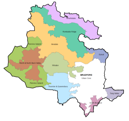
4.29.10 One of the distinctive qualities that landscapes of the South Pennines in Bradford District have are the locations, settlements, features and viewpoints that have cultural associations with the writings of the Brontes, who lived in Haworth. Rombalds Moor, settled since prehistoric times, and rich in remains (including numerous scheduled ancient monuments of carved rocks, burial mounds and stone circles) and the distinctive cow and calf rocks is also of significant value.
4.29.11 Landscape character assessments recognise the important role that boundary structures play in relation to the ecology, landscape and history of the District. Hedgerows and drystone walls can be threatened both directly by development decisions and indirectly when land use change leads to a more gradual process of neglect. Other historic elements in the landscape may relate to early agricultural systems and field patterns or to features linked to stages in the development of the textile industry, including trans-pennine routes and associated bridges and locks.
4.29.12 Work carried out at a district level by West Yorkshire Ecology to identify potential grassland, woodland, wetland and heathland habitat networks also forms part of the evidence base for this policy. The output maps from this work help to reinforce the importance of landscape features identified in character assessments, they can be used to focus the efforts of local authorities, key stakeholders and partners to maintain, restore and re-create landscapes and achieve biodiversity enhancement. Trees and woodlands throughout the District also play an important role in defining landscape character. Policy EN3 set out the approach to protecting trees and woodland.
4.29.13 The character of the Districts' landscape is therefore very varied, ranging from the rugged open moorland of the South Pennine uplands to rolling farmland, and open river valleys to wooded hillsides. The diversity of landscape character areas form an important element in Bradford's identity and the quality of life of its residents. The landscape backdrop is a significant influence on the character of individual settlements. Identified landscape character is therefore considered to be a key component of local distinctiveness that helps to create a 'sense of place'.
4.29.14 Within Bradford open moorland provides the backdrop to the wide shallow valleys of the rivers Aire and Wharfe, where locations along the moorland edge offer long extensive views. Within such an open landscape, in areas where there are few other structures, there is a need for extreme sensitivity in introducing vertical elements such as wind turbines within the wider landscape setting and protecting long range views where possible.
Policy Directions
4.29.15 The policy seeks to ensure that proposals for development and other projects, that could have an impact on the landscapes within the district, particularly, but not exclusively, those on the edge of settlements, contribute towards the management and enhancement of the District's landscapes, biodiversity and heritage resources.
4.29.16 The landscape policy contributes towards a range of other objectives, including the maintenance and restoration of habitats and the protection of historic assets (including parks and gardens) and their settings. The landscapes of the District are of tourism, leisure and recreational value and make a significant contribution to the appeal and character of the District. The policy has evolved in response to issues raised by consultees and the sustainability appraisal; key concerns were local distinctiveness, securing biodiversity gains and the need for landscape enhancement, particularly in the urban fringe. The issue of local distinctiveness is also addressed in Policy DS2: Working with the Landscape.
4.29.17 This policy reinforces the criteria identified in Policy SP10 in relation to elements that contribute towards Green Infrastructure. It complements the heritage policy EN4 in relation to historic elements in the landscape, the importance of setting and cultural associations. It has strong links with Policy EN2 relating to biodiversity as it also seeks to encourage greater connectivity and enhancement of habitats. Establishing ecological networks and landscape enhancement can achieve significant benefits for areas within the urban fringe where landscapes have been greatly influenced and/or degraded by human activity. In appropriate locations, protecting and linking belts of woodland can enhance the landscape and improve habitat connectivity. Reducing habitat fragmentation and increasing woodland cover can also make a contribution towards the District's resilience to climate change.
4.29.18 The NPPF supports the setting out of criteria based policies against which proposals for development affecting landscape will be judged and which give appropriate weight to the contribution made to wider ecological networks. Protecting and enhancing valued landscapes, geological conservation interests and soils is one of the means identified through which planning should make a contribution towards conserving and enhancing the natural environment. Planning policies and decisions should contribute to and enhance the natural and local environment by protecting and enhancing valued landscapes.
Policy EN5: Landscape
- Development decisions as well as plans, policies and proposals should make a positive contribution towards the conservation, management and enhancement of the diversity of the following landscapes within the District:
- Airedale
- Thornton and Queensbury
- Esholt
- Tong Valley
- Pennine Upland
- Rombalds Ridge
- Wharfedale
- Wilsden
- South Bradford
- Worth and North Beck Valley
The Landscape Character Assessment SPD should be used to guide the design of proposals to ensure that they respond to the particular landscape character type in which they are located.
- The following criteria will also be used to assess whether change can be considered acceptable:
- The potential for adverse landscape and/or visual effects.
- The importance of cultural associations, historic elements in the landscape and the setting of settlements and heritage assets
- The opportunity to contribute towards positive restoration of landscapes, particularly in the urban fringe, achieve greater habitat connectivity, enhancement of characteristic semi-natural vegetation and accessible natural greenspace
In circumstances where impacts can be managed and the degree of change made acceptable, contributions need to relate to the scale of the project under consideration, and the significance of any assets affected.
Where there is potential for adverse landscape and/or visual effects, a landscape and visual impact assessment or appraisal will be required. Proposals also need to fulfil the criteria set out in Policy DS2: Working with the Landscape.
Reasonable Alternatives – EN5: Landscape
- No alternatives considered - the policy is succinct and grounded in the evidence base and SPD work and no reasonable alternatives have been considered.
(9) Consultation Question 43
EN5: Landscape
The preferred policy is the existing Core Strategy policy carried forward with some minor wording amendments.
Q43. Please provide your comments for Policy EN5 and any suggested changes to the policy? If you would support an alternative to the Preferred Option, please provide further details and evidence to support this.
4.30 Preferred Option – EN6: Countryside and Development
4.30.1 Outside the City of Bradford, there are significant areas of the District defined as countryside which are intrinsic to the identity of the area including the South Pennine Moors, the Airedale Valley and Wharfedale Valley. Several areas are recognised in national planning policy (SSSI and SPA/SAC) as they provide a valuable recreational resource as well as having landscape and biodiversity benefits.
4.30.2 Policy EN6 aims to protect the countryside and manage development in a way that supports rural communities and the rural economy whilst maintaining its essential attributes.
4.30.3 The countryside is defined as everywhere outside of the settlement boundaries and the majority of the designated countryside is identified as Green Belt through Policy SP5 which seeks to restrict further development. Any proposals in such areas will also have to be determined through the requirements of Policy SP5.
Policy EN6: Countryside and Development
- Within the Countryside as defined on the Policies Map, development will be limited to:
- that needed for purposes of agriculture, forestry or other uses appropriate to a rural area, including uses which would help support and diversify the rural economy where there is an operational justification;
- renewable energy projects in line with Policy EN10 and would not harm the character of the countryside;
- the provision of dwellings for rural workers in accordance with Policy HO5;
- the reuse or rebuild of existing permanent and substantial buildings;
- minor extensions to existing dwellings and other buildings;
- development required for the essential continued operation of existing enterprises, facilities or operations, of a type and scale which would not harm the character of the surrounding countryside;
Where development is also located with the designated Green Belt, proposals must meet the requirements set out in Policy SP5.
- There shall be no loss to the existing public rights of way network that form part of the core walking and cycling network. Any new development that impacts on the network will have to provide mitigation measures included to offset any negative impacts. Proposals including the enhancement of existing network, the creation of new public rights of way and the promotion of disabled access to the countryside will be supported.
Reasonable Alternatives – EN6: Countryside and Development
4.30.4 The reasonable alternatives considered:
- No policy – which would leave some part of the district and countryside potentially unprotected.
- Integrate policy focus within landscape or other policy area – specific policy interest may not be effectively represented.
(150) Consultation Question 44
EN6: Countryside Development
This is a new policy which defines the area designated as countryside and sets out the approach to managing development in this designated area. Specifically, it restricts development to certain appropriate countryside compatible uses.
Q44. Please provide your comments for Policy EN6 and any suggested changes to the policy? If you would support an alternative to the Preferred Option, please provide further details and evidence to support this.
4.31 Preferred Option - EN7: Flood Risk
Introduction
4.31.1 The overall objectives of Policy EN7 are to appraise, manage and reduce the risk of flooding. The policy identifies the principles to guide the process of identifying locations for future development while seeking to reduce flood risk, assess proposals that come forward and adopt a positive approach to water management. Flood risk is defined in the PPG as: 'a combination of the probability and the potential consequences of flooding from all sources – including from rivers and the sea, directly from rainfall on the ground surface and rising groundwater, overwhelmed sewers and drainage systems, and from reservoirs, canals and lakes and other artificial sources'.
4.31.2 The NPPF requires Local Plans to take account of climate change over the longer term and plan new development to avoid increased vulnerability to the range of impacts arising from climate change. The sequential testing approach is supported and technical guidance has been produced setting out how this policy should be implemented. Key principles identified are; safeguarding land from development that is required, or likely to be required, for current and future flood management; using opportunities offered by new development to reduce the causes and impacts of flooding; and developing policies to manage flood risk from all sources. When applying sequential testing principles to the choice of sites for future development, where data exists, all sources of flood risk will be taken into account, including those associated with ground water flooding.
4.31.3 The Flood and Water Management Act 2010 has given Lead Local Flood Authorities responsibility for identifying sources of local flood risk and reducing the likelihood and impacts of local flooding. These sources include surface water run-off, groundwater and flooding from smaller rivers and streams. The Act ends the automatic right to connect surface water drains and sewers to the public sewerage system, with developers being required to use Sustainable Drainage Systems (SuDS) in new development, where practicable. Issues relating to the adoption and future maintenance of SuDS will need to be resolved by local authorities and developers.
4.31.4 The most important principle, in terms of managing risk, is that development should only be permitted in areas of high flood risk when no alternative land in areas of lower flood risk is available and the overall benefits of the development outweigh the risks from flooding. Risk should be reduced, at a strategic level, by safeguarding land from development that is required for flood water storage and defences, and using the opportunities offered by new development to incorporate SuDS, green infrastructure for water storage and the re-creation of the functional flood plain.
Local Environment
4.31.5 Bradford District includes the catchment areas of the River Aire and the River Wharfe, the latter forming a main river within the River Ouse catchment. Both the Aire and the Ouse play an important role in the future planning of neighbouring authorities within the Leeds City Region and beyond. The strategic level of appraisal that has been carried out to date, identifies flood risk as an important issue that needs to be addressed, particularly in the Regional City of Bradford and in Keighley and Ilkley.
4.31.6 The River Aire within Bradford District is characterised by a number of swift flowing upland streams which then flow down through the towns along the valley. The upper reaches of the River Aire within Bradford District have a largely rural character and the flood plain in the Silsden and Steeton with Eastburn area is quite extensive. The River Worth is one of the larger contributing catchments and joins the River Aire at Keighley.
4.31.7 The middle reaches of the River Aire are heavily urbanised and contain the towns of Keighley, Bingley, Shipley and the City of Bradford. Between Keighley and Leeds the valley floor steepens and becomes narrower. The density of development within the valley has resulted in significant restrictions to the natural floodplain.
4.31.8 Periods of heavy rainfall in the uplands can therefore produce high flows in the tributary catchments between Keighley and Bradford. This problem becomes most acute in densely developed areas where gradients are steep, for example within the heavily modified Bradford Beck corridor.
4.31.9 The functional floodplain identified for the Beck has been based on the Bradford Beck Model. Information from the modelling work and subsequent SFRA has been used to inform the approach taken to managing flood risk in the City Centre and Shipley & Canal Road Corridor areas, particularly in terms of the provision of blue and green infrastructure and restoring the natural character of the Bradford Beck where possible.
4.31.10 The River Wharfe skirts the settlements of Addingham, Burley-in-Wharfedale and passes through the central area of Ilkley. It is a fast reacting river with flood flow rapidly passing downstream. As well as flows that come down from the upper Wharfe, there are a number of smaller streams and becks descending from the moors in Wharfedale, which can be a source of flood risk in extreme rainfall events. The importance of flood storage provision within the Aire and Wharfe corridors and of flood risk from the Becks and links with green infrastructure are key challenges.
Surfacing Water Flooding
4.31.11 Surface water flooding can occur where extensive rainfall exceeds the drainage capacity in an area. The shape of the landform in Bradford, especially in and around a number of the built-up areas, makes the district potentially prone to flooding caused by direct rainfall, due to the extent of hard surfaces and a lack of sufficient sewer capacity. In addition to causing flooding to property, surface water runoff can lead to water quality issues and potential health risks.
Policy Development and Technical Assessments
4.31.12 All forms of flooding and their impact on the natural and built environment are planning considerations. The Council's commitment is to achieve the overall objectives of this policy including those of appraising, reducing and managing all sources of flooding. Policy EN7 should also be read alongside Policy SP9 (Climate Change); Policy SP10 (Green Infrastructure) and Policy EN9 (Environmental Protection) as a set of inter-related policies.
4.31.13 A Level 1 Strategic Flood Risk Assessment (SFRA) was prepared for the Bradford District in 2019 and provides data and guidance to inform the flood risk policies and allocations in the Local Plan. However, following objections from the Environment Agency, an update to the SFRA has been commissioned to take account of updated river models which are in the process of being prepared. These new models are not yet fully available or have not been signed-off by the Environment Agency and therefore the revised SFRA has not yet been completed. The preparation of the Local Plan for this consultation stage has therefore relied on the best available evidence at the time (the 2019 SFRA) and supplemented with updated flood risk information where possible.
4.31.14 The Council is aware that the Local Plan will need to be updated once the revised SFRA has been produced to take account of any changes which have been identified due to the new river modelling. It will also allow the Council to carry out a Level 2 SFRA for those allocations which fall within an area of flood risk.
4.31.15 The SFRA identifies the functional flood plain (Flood Zone 3b), comprising largely of open and undeveloped land where water has to flow or be stored in times of flooding. It also identifies areas naturally vulnerable to surface water flooding and considers the potential impact of climate change which will help to identify locations for future development.
4.31.16 The SFRA provides a framework for the overall appraisal and management of risk. It allows the identification of land with the lowest probability of flooding that would be appropriate to the type of development or land use proposed. Information from the SFRA and Sustainability Appraisal will be used to demonstrate the principle of sequential testing at a strategic level.
4.31.17 Policy EN7 supports the extent of the functional flood plain identified in the SFRA, allowing only water compatible uses and essential infrastructure after the Exception Test has been passed. The SFRA indicates that the functional flood plain forms a very important planning tool in making space for flood waters when flooding occurs and that development should be directed away from these areas.
4.31.18 While major parts of urban Bradford lie outside the flood plain, the SFRA notes that some built up areas are at risk of flooding from a number of different sources. Flooding has been recorded when the River Aire overtops into the Leeds-Liverpool Canal, causing increased flood risk to communities located close to the canal network. Shipley is identified as an area at risk from a number of different sources of flooding, as is Keighley which has experienced groundwater and surface water flooding as well as fluvial flooding.
Policy EN7: Flood Risk
- The Council will manage flood risk pro-actively through plan making and in assessing proposals for development. In particular, it will:
- Direct development to areas with the lowest risk of flooding. Where applicable, apply the sequential test and, if necessary, the exception test; taking into account the potential impacts of climate change.
- Ensure that development proposals: address all sources of flooding; do not increase flood risk elsewhere; and take account of the need for improved drainage infrastructure.
- Require applications to be supported by a site-specific flood risk assessment in line with the requirements of the NPPF. The assessment should address the risks from all sources of flooding; including fluvial, surface and ground water flooding and should make allowances for the potential impacts of climate change.
- Ensure that any new development in areas of flood risk is appropriately resilient and resistant and made safe for its lifetime without increasing the flood risk elsewhere.
- Where development is proposed in areas of higher flood risk (Flood Zones 2 and 3a) and it meets the sequential and exception tests, it should include flood mitigation measures such as the compensatory storage of flood water, which should be identified and considered through a site specific flood risk assessment.
- Safeguard areas which have the potential to increase flood storage provision and improve defences within the Rivers Aire and Wharfe corridors.
- Manage and reduce the impacts of flooding within the beck corridors, in a manner that enhances their value for wildlife and helps to increase biodiversity, this may include the use of natural flood management processes.
- Adopt a holistic approach to flood risk in the Bradford Beck corridor in order to deliver the regeneration projects set out in the City Centre and Shipley & Canal Road corridor areas in the Local Plan.
- Seek to minimise surface water run-off from new development:
- on Brownfield sites drainage proposals will be measured against the existing performance of the site but will be encouraged to reduce run-off rates by at least 30%.
- on Greenfield sites there should be no change to the existing overall run-off rate and where possible improvements should be made to reduce it.
- Require surface water to be drained on a separate system, with proposals following the drainage hierarchy in order of priority:
- drain into the ground (infiltration)
- drain to a surface water body
- drain to a surface water sewer, highway drain or another drainage system
- drain to a combined sewer.
- Require major developments, and where appropriate all other developments, to incorporate SuDS in a manner that is integral to site design, achieves high water quality standards and maximises habitat value, unless it can be demonstrated that this is not technically feasible. Arrangements should be made to ensure the management and maintenance of the SuDS scheme for the lifetime of the development. Retrofitting SuDS into existing developments will also be supported where the opportunities arise.
- Use flood risk data to inform decisions made about Green Infrastructure provision.
- Identify opportunities and support proposals for natural flood management, including the restoration of culverted watercourses to open channels, tree planting schemes, and the restoration of blanket bog.
- Only support the use of culverting for ordinary water courses, and additional flood defence works that could have adverse impacts on the environment, in exceptional circumstances.
- The Council will not permit development in areas which are within the functional floodplain (Flood Zone 3b) as defined in the most up-to-date SFRA with the exception of water compatible uses and essential infrastructure.
Reasonable Alternatives – EN7: Flood Risk
- No reasonable alternatives identified - the policy is strengthened relating to Surface Water run-off, SuDS and Natural Flood Management. The policy has been updated to reflect new SFRA and other flood risk management strategies. However, with a number of new river models being prepared by the Environment Agency, the SFRA will require a further update and consequentially the policy may require further changes.
(158) Consultation Question 45
EN7: Flood Risk
This policy looks at how the Council will pro-actively manage flood risk across the district as part of new development and plan making.
The preferred option has seen the policy strengthened to clarify the application of the sequential and exception tests, require planning applications to be supported by a site-specific flood risk assessment where applicable, introduces the drainage hierarchy and requires major developments to incorporate SuDS. It also clarifies the surface water run-off rates for both Brownfield and Greenfield development and supports proposals for natural flood risk management.
Q45. Please provide your comments for Policy EN7 and any suggested changes to the policy? If you would support an alternative to the preferred option, please provide further details and evidence to support this.
4.32 Preferred Option - EN8: Air Quality
Introduction
4.32.1 Historically, the main air pollution problem in the UK has typically been high levels of smoke and sulphur dioxide emitted following the combustion of sulphur-containing fossil fuels such as coal, used for domestic and industrial purposes. Today the major threat to clean air is now posed by traffic emissions and particularly in locations next to busy roads. Petrol and diesel-engined motor vehicles emit a wide variety of pollutants, principally carbon monoxide (CO), oxides of nitrogen (NOx), volatile organic compounds (VOCs) and particulate matter (PM2.5 & 10), which have an increasing impact on urban air quality. The most dangerous pollution is made up of nitrogen dioxide (or NO2) and fine particles or particulate matter. It has been shown that diesel cars can produce significantly more emissions than petrol cars. Wood burning stoves are also a significant source of air pollution, producing over 30% of particulate emissions.
4.32.2 In addition, pollutants from these sources may not only prove a problem in the immediate vicinity of these sources, but can be transported long distances. Photochemical reactions resulting from the action of sunlight on nitrogen dioxide (NO2) and VOCs, typically emitted from road vehicles, lead to the formation of ozone. Ozone is a secondary pollutant, which often impacts rural areas far from the original emission site as a result of long-range transport.[6]
4.32.3 Improving air quality within Bradford District is a key priority and the Local Plan can influence air quality through a number of policy areas and measures including:
- where development is located and how it is supported – overall growth and distribution strategies and proximity to services, facilities and travel options;
- the types of places that are built – development of active healthy streets, levels of green infrastructure and open space.
- effective infrastructure planning – to provide real alternatives to private car use through developing bus and rail options and cycling and walking alternatives
4.32.4 In circumstances where air pollution is prevalent, planning can also promote design to minimise the potential impacts on human health, welfare and the natural environment.
4.32.5 This policy is concerned with ensuring that the implications of growth in relation to air pollution are minimised at a strategic level and developments are designed to minimise the impact of pollution where this in prevalent in the short-term.
National Planning Policy
4.32.6 The NPPF (paragraph 181) indicates that planning policies and decisions should sustain and contribute towards compliance with relevant limit values or national objectives for pollutants, taking into account the presence of Air Quality Management Areas and Clean Air Zones, and the cumulative impacts from individual sites in local areas.
4.32.7 New development should therefore identify opportunities to improve air quality in affected areas and ensure sufficient mitigation of any impacts resulting from the development is put in place. This may include traffic and travel management, and the provision and enhancement of green infrastructure.
4.32.8 Air pollution doesn't just have an impact on human health, the NPPG highlights the need to take into account air quality management areas, and Clean Air Zones and other areas including sensitive habitats or designated sites of importance for biodiversity where there are specific requirements or limitations on new development in habitat assessments, strategic environmental assessments and sustainability appraisals.
4.32.9 The NPPF is also clear that when it comes to planning decisions, any new development in Air Quality Management Areas and Clean Air Zones is consistent with the local air quality action plan.
Local Picture
4.32.10 The Council has been monitoring real time air pollution levels since 1999 and several locations have been identified in the Bradford District where levels of nitrogen dioxide are higher than the legal limits. Pollution levels can vary because of changes in the weather, time of year and time of day. The following figure shows those areas within the study area which have the highest average levels of Nitrogen Dioxide (shown in purple and dark brown).
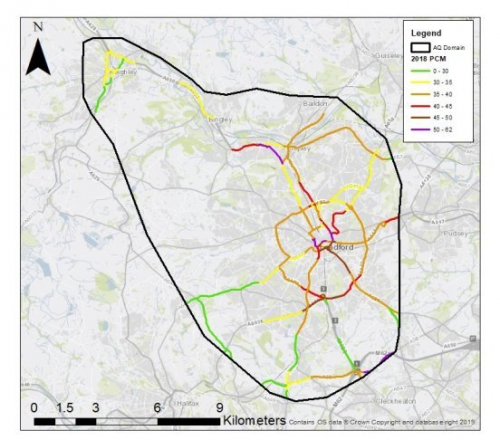 Figure 4.32.1: Bradford and Air Pollution
4.32.11 Bradford has declared four Air Quality Management Areas (AQMAs) where the annual mean levels of nitrogen dioxide have exceeded the maximum legal limits. Poor air quality is linked to respiratory illnesses, heart disease and asthma and is a major public health concern.
4.32.12 Research by Born in Bradford has shown that during pregnancy exposure to pollutants commonly found in the air, such as those from traffic, causes babies to be born at a lower birth weight, even where the pollution is at levels well below those allowed in current European Union (EU) air-quality rules. A low birth weight is serious because it is a predictor of other health problems in childhood and later life. The research has also shown that having a local natural 'green' environment to walk in, such as parks and woods, has a beneficial effect for both mothers and children.[7]
Strategies and Proposals
4.32.13 The Council has prepared both an Air Quality Strategy (2011) and Low Emission Strategy (2013) setting out its commitment to taking a pro-active stance in addressing air quality issues. The impact of transport is a cross-boundary issue and the five West Yorkshire Local Authorities have prepared the West Yorkshire Low Emissions Strategy (2016-2021) which outlines the key challenges in relation to air quality within West Yorkshire.
4.32.14 At a national level the government has prepared a UK Air Quality Plan and a Clean Air Zone Framework as part of its response to addressing air quality breaches across the country and to comply with EU legislation on Limit Values. Bradford Council has received Ministerial Direction from the Government to produce a business case for an Air Quality Plan to achieve air quality compliance in the shortest time possible. The Council is preparing this plan and has consulted with residents about launching a Charging Clean Air Zone (CAZ). The CAZ is scheduled to commence in January 2022 and certain non-compliant vehicles, excluding private cars, will be subject to a daily charge shown in the Clean Air Zone charging table.
4.32.15 The CAZ is a defined area where targeted action is taken to improve air quality. It can be confined to a single road, part of a city or an entire district. The main objective of the Clean Air Zone is to discourage the use of older, more polluting vehicles from entering the zone by setting a charge for entering. Through the use of this charge the Council will encourage vehicle owners to consider upgrading their vehicles to compliant standards. The zone has special signs and is enforced with automatic number plate recognition (ANPR) cameras.[8]
4.32.16 The area covered by the CAZ proposals are detailed below in Figure 4.32.2.
Figure 4.32.2: Proposed Clean Air Zone
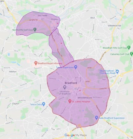
Making the Connections
4.32.17 The Government's Clean Air Zone Framework highlights the best use of the local authority role in land use planning and specifically details where a Clean Air Zone is introduced it should be identified in the local plans and policies and local transport plan at the earliest opportunity to ensure it is consistent with wider ambitions.
4.32.18 How and where building and other developments are planned and built can have an effect on air quality. Approaches to planning in Clean Air Zones can help support a range of themes in this framework and encourage more sustainable behaviour, for example in the way people use electric vehicles and by making cycling and walking easier and more attractive. There are also opportunities to make strong links to approaches to other environmental behaviours including nature conservation, waste minimisation and energy efficiency.[9]
4.32.19 Addressing air quality issues is recognised within the local plan to be complementary to the aim of achieving a reduction in emissions from transport. This is reflected in transport policies including SP7, TR1, TR2, TR3 and TR5 and the overall strategic approach to addressing climate change (Policy SP9) and creating healthy places (Policy SP15). The local plan also features a strong focus upon protecting and enhancing open spaces (Policy CO1), protecting biodiversity (Policy EN2) and integrating and further developing the District's green infrastructure network (Policy SP10).
4.32.20 The need to accommodate growth particularly in the Bradford 'basin' and transport corridors leading out of the city is likely to exacerbate air quality issues in the future if actions are not instigated to address them. This may lead to serious impacts on the health of residents, who already see relatively high incidents of death from heart disease and a high number of cases of asthma. Furthermore, for the first time air pollution has been linked as a major contribution to the death of a child in 2013 following a Coroner Court case in 2019.[10]
4.32.21 As well as addressing air quality in the AQMAs there is a need to look at the broader impacts of emissions and air pollution on the wider environment. The policy seeks to ensure that development proposals which are likely to have an adverse impact on air quality suitably address these issues.
4.32.22 Further air quality modelling work is to be carried out to assess the possible effects of sites and traffic flows on areas of air quality concern, including the European Designated sites for nature conservation. The modelling will look at the effects on air quality from increased traffic as a result of the potential development of the sites selected for allocation. It will consider the impact of those effects on the European sites and the surrounding communities. This information will be used to put in place relevant mitigation measures to ensure that there are no adverse effects on the European sites. The policy is therefore likely to be updated in light of this modelling work.
Policy EN8: Air Quality
- The Council is committed to tackling air pollution and improving air quality throughout the District in an effort to improve the health and wellbeing of its residents and visitors. The Council will work with partners and stakeholders to implement the Clean Air Plan and ensure the individual and cumulative impacts of new developments are minimised to achieve reductions in pollutant emissions and minimise public exposure to air pollution.
- New development through site allocations as set out in Policy HO1 and section 5 of the plan will be located in sustainable locations within close proximity to public transport. Improvements to cycling and walking networks under Policies SP7 and TR1 should aim to provide alternative active travel options and development should be designed to create healthy places in line with Policies SP14, SP15 and DS4. The location of industrial and energy uses should be carefully considered in light of potential air pollution and proposals for an enhanced green infrastructure network (Policy SP10) will be supported to assist in the absorption of air pollutants.
- To reduce the air pollution impact of new developments and to improve air quality District wide, major developments should:
- Minimise increased exposure to existing poor air quality, such as through the use of design solutions, buffer zones including green infrastructure or steps to promote greater use of sustainable transport modes through travel plans.
- Minimise the level of air pollution resulting from the operation of the development including particulates.
- Employ sustainable design and construction methods to reduce air pollutants from the demolition and construction of buildings.
- Ensure that where provision needs to be made to reduce emissions from a development, this is usually made on-site. Where it can be demonstrated that on-site provision is impractical or inappropriate, equivalent air quality benefits should be provided off-site;
- Where biomass boilers and other solid fuel heating appliances are included within the scheme, permission should only be granted if no adverse air quality impacts of these heating systems are identified.
- In an effort to tackle the significant air quality issues within the CAZ (as identified on the Policies Map), all major developments will be expected to submit an Air Quality Assessment and where necessary modelled data, which will demonstrate the following:
- Result in no increase in air pollution from the operation of the proposed development and, therefore, be at least 'air quality neutral' and not lead to further deterioration of existing poor air quality.
- Employ the use of sustainable design and construction methods to minimise air pollutants from the demolition and construction of buildings in line with the guidance set out in the CAZ SPD.
- Result in no increased exposure to existing poor air quality and make provision to address local problems of air quality, such as through the use of design solutions, buffer zones or steps to promote greater use of sustainable transport modes through travel plans.
- Result in no increased exposure for the natural environment – particularly sensitive habitats and designated sites of importance for biodiversity.
- Mitigation measures to reduce emissions resulting from the development are made on-site and protect occupiers from pollution sources.
- The heating of buildings or any associated part of the development will not use biomass boilers or solid fuel appliances and should maximise the use of renewable and low carbon energy sources in line with Policy EN10.
- Very strict mitigation measures will be required for sensitive receptor developments, including schools, hospitals and care facilities and developments within their immediate vicinity.
Air quality issues and mitigation measures to tackle these are set out in detail within the CAZ SPD, including requirements for the Air Quality Assessment. Planning applications and supporting documents are expected to follow the practical guidance set out within the SPD to ensure that they are fully compliant with Policy EN8 Air Quality.
Reasonable Alternatives – EN8: Air Quality
4.32.23 The reasonable alternatives considered included:
- Reducing the threshold from major developments to all developments in relation to air quality requirements and assessment – this is subject to further questioning as part of this consultation.
- Increasing threshold to developments of 50 units and over for residential and similar threshold setting for non-residential – this would exclude a significant proportion of the District's historic housing supply and potentially lead to a more ineffective policy.
- Keeping policy detail within the wider environmental policy context – the increasingly specific and technical nature of the policy justifies separate detailing.
(151) Consultation Questions 46
EN8: Air Quality
The policy sets out a detailed series of measures to support an improvement in air quality at a strategic level and minimise the impact on human and ecological health in areas of poor air quality, particularly within the proposed CAZ.
Q46a. The policy includes reference to a minimum threshold of major developments for addressing development considerations and assessment. Major development is defined as for housing, development where 10 or more homes will be provided, or the site has an area of 0.5 hectares or more, and for non-residential development it means additional floorspace of 1,000m2 or more, or a site of 1 hectare or more, or as otherwise provided in the Town and Country Planning (Development Management Procedure) (England) Order 2015. Do you consider this an appropriate threshold to be set within the policy? If not please provide further information.
Q46b. Please provide any other general comments for Policy EN8 and any suggested changes to the policy? If you would support an alternative to the preferred option, please provide further details and evidence to support this.
4.33 Preferred Option - EN9: Environmental Protection
4.33.1 The NPPF (paragraphs 178-180) sets out the requirements for addressing the risks posed by pollution and contamination. It specifically indicates that planning policies should ensure that proposals take account of ground conditions and any risks arising from land stability and contamination. It also requires development to be appropriate for its location having regard to likely effects of pollution on health, living conditions and the natural environment. Any potential adverse impacts should be kept to a minimum and adequately mitigated.
4.33.2 It is important that the quality of land, air and water in the District is protected and not adversely affected by new development. Policy EN9 covers a number of areas relating to pollution control including land, nuisance, and water quality. The development of Brownfield land is likely to raise some of these environmental protection issues due to former land uses. However, development of greenfield or Green Belt land may also raise issues such as land stability linked to former mining activity, the presence of pollutants associated with current agricultural practices or health and safety concerns associated with electricity pylons and power lines.
Contaminated Land
4.33.3 The legacy of past manufacturing, engineering and industrial processes, has resulted in the potential for residual contamination of sites across the District. The focus on encouraging the recycling of Brownfield land and the need to identify suitable sites for accommodating future growth means that land contamination is an important planning consideration. Sites must be subject to appropriate investigation and assessment of potential risks associated with previous land uses in order to determine their suitability for alternative uses. Any such contamination issues will need to be resolved before development can progress.
4.33.4 Soil is an important resource for wildlife, food production and the general ecological well-being of the planet, and should be protected from being polluted or becoming contaminated through development processes. Where soil is found to be contaminated on a development site, measures should be put in place to ensure adequate remediation and/or safe disposal of the effected soil.
Hazardous Installations
4.33.5 There are a number of sites within the District where significant quantities of potentially hazardous chemicals are used and stored. This can place significant restrictions on the amount and types of development that can be located in the surrounding area.
Nuisance
4.33.6 Nuisance issues can include noise, dust, odour and lighting which can have a significant impact on the quality of life. When identifying land for development and in responding to development proposals, consideration of existing land uses within the vicinity of the site need to be taken into account.
Water Quality
4.33.7 There are a number of important water assets within the Bradford District, including the Rivers Aire, Wharfe and Worth, which continue to shape the landscape and provide valuable wildlife habitats, areas for recreation, and a supply of water for consumption. It is therefore imperative that the water environment is protected from pollution and contamination, and efforts are made to improve the quality of these water assets.
4.33.8 The Water Framework Directive (WFD) establishes the legal framework for the protection of surface and ground waters. It provides a set of common objectives, principles and basic measures for the management of the water environment.
4.33.9 The Environment Agency has prepared a number of River Basin Management Plans to support the implementation of the WFD. Bradford District is covered by the management plan for the Humber and addresses the integrated management of the water environment, supporting initiatives to prevent and mitigate the effects of floods and droughts.
4.33.10 Policy EN9 seeks to support the delivery of the main aims of the directive and recommendations of the Humber River Basin Management Plan, which include:
- preventing the deterioration of aquatic systems;
- helping to restore polluted surface water and ground water to a good ecological and chemical status. (This may in part be achieved through the restoration of physically modified water courses, to allow the water body to return to a more natural state);
- reducing pollution;
- promoting water efficiency in new development;
- identifying opportunities for ecological enhancement;
- promoting use of sustainable drainage systems (Policy EN7);
- ensuring flood risk is not increased and is reduced where possible (Policy EN7).
4.33.11 The policy addresses the need to protect water resources and water quality and ensures the efficient use of water. It recognises the potential impact that new development and growth could have on water resources and quality in the District.
Policy EN9: Environmental Protection
In order to protect public health and the environment the Council will require that:
Proposals which are likely to cause pollution or are likely to result in exposure to sources of pollution (including noise, odour, light, water or soil pollution) or risks to safety, will only be permitted if suitable and sustainable mitigation measures can be implemented to minimise the pollution and risk to a level that provides a high standard of protection for health, environmental quality and amenity.
The following issues require particular attention:
Land
- Proposals for development of land (including soil) which may be contaminated or unstable must incorporate appropriate investigation into the quality of the land. Where there is evidence of contamination or instability, remedial measures must be identified and delivered as part of the development to ensure that the development will not pose a risk to human health, public safety and the environment. Investigation of land quality must be carried out in accordance with the principles of best practice.
Nuisance
- Proposals for development must identify potential nuisance issues (including noise, vibration, odour, light and dust) arising from the nature of the proposal and address impacts on that development from existing land uses.
Water Environment
- The Council will work with developers and partner organisations to:
- safeguard ground and surface water resources, including protecting Source Protection Zones from contamination;
- ensure no deterioration of water courses or water bodies occurs;
- ensure that development does not jeopardise any water body from achieving its Water Framework Directive objective of 'good' status; and
- protect and improve water quality.
Proposals for development will only be acceptable where there is no adverse impact on water bodies and groundwater resources, in terms of their quantity, quality and the important ecological features they support.
Proposals for development will be supported where they:
- make positive progress towards achieving 'good status or potential' under the Water Framework Directive for surface and groundwater bodies.
- enhance the natural geomorphology of watercourses, including through the opening up of culverts and removal of modifications made as part of past industrial uses, or through the restoration of man-made channels.
- manage water demand and improve water efficiency through the use of appropriate measures including rainwater harvesting and grey-water recycling.
- include measures which help to reduce the potential for, or mitigate against water shortages or drought.
Reasonable Alternatives – EN9: Environmental Protection
4.33.12 The reasonable alternatives considered:
- No change to the previous iteration of the policy – this would see the retention of the air quality section (now included in a standalone policy due to the acute issues found in Bradford which requires a separate policy response), explicit references to soils not being included, and less clarity on achieving the Water Framework Directive objectives.
- Include a separate policy on the Water Environment – this would provide a stronger, separate focus on water quality and resource issues, however, it would reduce the comprehensive nature of this environmental protection policy which considers pollution and contamination issues as a whole.
(155) Consultation Question 47
EN9: Environmental Protection
The overall aim of the policy is to protect public health and the environment by ensuring that all forms of pollution are minimised and adequately mitigated as part of new developments.
Air quality is now considered under a separate policy (EN8) to provide sufficient focus on this important issue and address the specific local nature of the problem within the Bradford Urban Area. The remaining elements of this policy have been further strengthened with new references to soil pollution, and additional clarity in the wording relating to meeting Water Framework Directive objectives.
Q47. Please provide your comments for Policy EN9 and any suggested changes to the policy?
If you would support an alternative to the Preferred Option, please provide further details and evidence to support this.
4.34 Preferred Option: EN10: Energy
Introduction
4.34.1 Policy EN10 should be read in conjunction with strategic policy SP9 which focuses upon climate change, environmental sustainability and resource use and policy HO9 Housing Standards. The purpose of the energy policy is to provide a practical policy framework to support a move to a lower carbon future, although it is recognised that further technical evidence is required in relation to aspects of the policy to support the next edition of the plan.
4.34.2 Energy use solely in UK housing accounts for 27% of total carbon emissions with heating and powering all types of buildings accounting for 40% of total energy usage and therefore minimising energy use, improving energy efficiency and using more renewable and sustainable energy sources is fundamental to tackling climate change.[11]
4.34.3 As noted previously at a sub-regional and local level, both the Council and the wider Leeds City Region have declared a Climate Emergency and have formed a Climate Coalition which aims to achieve a net zero carbon region by 2038, with significant progress being made by 2030. Net zero carbon means emissions produced and emissions taken in are balanced. A significant focus within the declaration concerns energy related issues, with headline practical projects by the Council ranging from reducing the energy used in street lighting; delivering a District heat network; expanding the network of electric vehicle (EV) charging points and numbers of EV vehicles, to increasing renewable energy and electricity generation on the council estate and embracing opportunities for the use of hydrogen.
National Planning Policy and Guidance
4.34.4 National planning policy is clear that the planning system should support the transition to a low carbon future in a changing climate, taking full account of flood risk and coastal change. It should help to: shape places in ways that contribute to radical reductions in greenhouse gas emissions, minimise vulnerability and improve resilience; encourage the reuse of existing resources, including the conversion of existing buildings; and support renewable and low carbon energy and associated infrastructure (NPPF paragraph 148).
4.34.5 Under national policy (paragraph 151), local plans should provide a positive strategy for the use and supply of renewable and low carbon energy and heat that maximises the potential for suitable development, while importantly ensuring that adverse impacts are addressed satisfactorily (including cumulative landscape and visual impacts). Plans should also consider identifying suitable areas for renewable and low carbon sources and supporting infrastructure together with opportunities for development to draw its energy supply from decentralised, renewable or low carbon energy supply systems and for co-locating potential heat customers and suppliers.
4.34.6 LPAs are also encouraged as part of the wider Development Plan to support community-led initiatives for renewable and low carbon energy, including developments outside areas identified in local plans or other strategic policies that are being taken forward through neighbourhood planning (paragraph 152). Neighbourhood Development Orders and Community Right to Build Orders can be used to grant planning permission for renewable energy development. To support community based initiatives the NPPG details that local planning authorities should set out clearly any strategic policies that those producing neighbourhood plans or Orders will need to consider when developing proposals that address renewable energy development.
4.34.7 The NPPF also includes a footnote (49) which indicates that wind energy development involving one or more turbines should not be considered acceptable unless it concerns the repowering of existing wind turbines or is in an area identified for wind energy in the development plan and following consultation the planning impacts have been fully addressed and the proposal has the local community's backing.
4.34.8 National policy guidance indicates that while there is no 'hard and fast' rules for suitable areas for renewable energy in considering locations they need to take into account the requirements of the technology and critically the impacts on the local environment including cumulative impacts. Suitable areas for wind energy development will need to have been allocated clearly in a Local or Neighbourhood Plan – planning applications should not be approved unless the proposed development site is in an area identified as suitable for wind energy development in the Development Plan.
4.34.9 In developing an area strategy and approach to renewable and low carbon energy there is extensive published national policy guidance covering:
- methodologies for identifying suitable areas for energy projects;
- technical considerations for siting projects generally and specific planning considerations in terms of hydropower, active solar technology, solar farms and wind turbines;
- decentralised energy;
- decommissioning infrastructure, and
- planning application considerations.
4.34.10 In relation to building standards, local planning authorities may include policies in their local plans which require developers to comply with energy efficiency standards for new homes that exceed the minimum requirements of the Building Regulations. The Planning and Energy Act 2008 was amended in 2015 to provide Government with powers to stop local planning authorities from being able to exceed the minimum energy efficiency requirements of the Building Regulations, but this amendment has not been commenced.
4.34.11 In 2015 Government also set out in a Written Ministerial Statement an expectation that local planning authorities should not set energy efficiency standards for new homes higher than the energy requirements of Level 4 of the Code for Sustainable Homes, which is equivalent to a 19% improvement on the Building Regulations Part L 2013 standard. This position over standards setting has naturally caused confusion for LPAs and developers and Government has recently, through its response to the Future Homes Standard, stated that LPAs will retain powers to set local energy efficiency standards for new homes - although this may be utilised less frequently as energy efficiency standards for new homes improve.
Wider Policy Directions
4.34.12 In 2017, the UK Government set out its blueprint for a low carbon future in the 'Clean Growth Strategy' linking investment in green energy to economic growth. A further focus upon environmental policy and supporting green jobs to accelerating a route to net zero was published by the UK Government in 'The Ten Point Green Plan for a Green Industrial Revolution' (November 2020).
4.34.13 The ten-point green plan focuses upon a wide range of environmental priorities, including:
- Offshore wind: Producing enough offshore wind to power every home, quadrupling how much we produce to 40GW by 2030, supporting up to 60,000 jobs.
- Hydrogen: Working with industry aiming to generate 5GW of low carbon hydrogen production capacity by 2030 for industry, transport, power and homes, and aiming to develop the first town heated entirely by hydrogen by the end of the decade.
- Nuclear: Advancing nuclear as a clean energy source, across large scale nuclear and developing the next generation of small and advanced reactors, which could support 10,000 jobs.
- Electric vehicles: Backing our world-leading car manufacturing bases including in the West Midlands, North East and North Wales to accelerate the transition to electric vehicles, and transforming our national infrastructure to better support electric vehicles.
- Public transport, cycling and walking: Making cycling and walking more attractive ways to travel and investing in zero-emission public transport of the future.
- Jet Zero and greener maritime: Supporting difficult-to-decarbonise industries to become greener through research projects for zero-emission planes and ships.
- Homes and public buildings: Making our homes, schools and hospitals greener, warmer and more energy efficient, whilst creating 50,000 jobs by 2030, and a target to install 600,000 heat pumps every year by 2028.
- Carbon capture: Becoming a world-leader in technology to capture and store harmful emissions away from the atmosphere, with a target to remove 10MT of carbon dioxide by 2030, equivalent to all emissions of the industrial Humber today.
- Nature: Protecting and restoring our natural environment, planting 30,000 hectares of trees every year, whilst creating and retaining thousands of jobs.
- Innovation and finance: Developing the cutting-edge technologies needed to reach these new energy ambitions and make the City of London the global centre of green finance.
4.34.14 Many of the priorities are filtered into national regional and local strategies for tackling climate change, including the recent announcement by Government on the Future Homes Standard.
Future Homes Standard and Building Regulations
4.34.15 The Government has recently provided its response to proposed changes to the Building Regulations in relation to an uplift in the energy efficiency of new homes through changes to Part L (Conservation of fuel and power) of the regulations[12] and also published as part of the future building standards consultation proposed new energy and ventilation standards for new and existing non-domestic buildings and existing buildings, as well as addressing overheating in residential buildings.[13]
4.34.16 Key directions from Government in the consultation response on the Future Homes Standard indicates that:
- the performance standard set for the Future Homes Standard should produce 75-80% less CO2 emissions than built to current requirements;
- heat pumps will become the primary heating technology for new homes built under the Future Homes Standard;
- heat networks will also have an important role to play integrating the lowest-carbon heat sources and exploiting larger scale renewable and recovered heat sources such as energy from waste, waste heat and heat from other sources;
- delivering carbon reductions through the fabric and building services of a house rather than relying on carbon offsetting;
- local planning authorities will retain powers to set local energy efficiency standards for new homes;
- legislation on Future Homes Standard in 2024 with implementation from 2025, and
- an interim uplift to Part L standards (2021) (all building types) to come into effect in 2022 with the expectation that homes built under this interim standard will produce 31% less CO2 emissions compared to current standards.
4.34.17 The Government's consultation on standards for non-domestic and existing buildings is ongoing but with the ambition that the Future Buildings Standard will be implemented by 2025.
Local Energy Strategy Directions
4.34.18 Research by Leeds City Region suggests that clean growth could add £11bn to the city region economy and create 100,000 extra skilled jobs for local people. The Leeds City Region Energy Strategy and Delivery Plan concentrates upon five key zero carbon energy economy ambitions:
- Resource-efficient businesses and industry – we will increase support to help companies reduce their energy costs and carbon emissions
- New energy generation – we will develop an energy network that provides locally generated low-cost, low carbon energy to homes and businesses, including district heat networks and the landmark H21 hydrogen energy project in Leeds
- Energy efficiency and empowering consumers – we will help households become more energy-efficient, lower their energy bills and reduce fuel poverty
- Smart grid systems integration – we will develop the technology and infrastructure that enables people and businesses to use energy more intelligently
- Efficient and integrated transport – we will target investment and influence transport operators to develop a sustainable transport network, including a greater proportion of electric and hydrogen-powered vehicles and increased opportunities for cycling and walking
4.34.19 The West Yorkshire Combined Authority and Leeds City Region Enterprise Partnership (LEP) joint commission on Emission Reduction Pathways sets a process to determine what measures are required to create a zero carbon economy across buildings, industry, land use and agriculture, power and transport. Its key findings suggest that to reduce emissions by 100 per cent and achieve a 2038 net-zero target this will require:
- between 73% and 82% of emissions savings – translating broadly to:
-
- For transport - reducing private car travel by 21% through shifting demand to public, shared and active travel e.g. walking and cycling; increasing travel by walking by 78%; increasing travel by bike by 2,000%; increasing travel by bus by 39% and increasing travel by rail by 53%.
- For buildings and industry - retrofitting nearly 700,000 homes with energy efficiency measures such as loft and cavity wall insulation, and installing heat pump heating systems in 665,000 homes and businesses.
- For power - generating enough electricity from onshore wind and solar to power more than 162,000 homes and implementing carbon capture and storage technology at four existing waste facilities and at two new proposed sites.
- For land use and agriculture - increasing the area of tree coverage by the equivalent of 452 football pitches; restoring 100% peatland and reducing food waste by 38%.
- the remaining 27% to 18% could be reduced through a combination of specific ambitious measures and innovative new technologies as they become available - examples of more ambitious measures we could take include:
-
- Increasing the amount of land allocated to the planting of trees.
- Generating more electricity from large-scale solar farms.
- Maintaining levels of remote working seen throughout the COVID-19 pandemic.
- Providing funding and support for innovative emission reduction technologies.
4.34.20 The emission pathway work recognises that West Yorkshire produces only a quarter of the power it consumes and is dependent on importing power from the National Grid. It lacks large-scale power plants such as those seen in neighbouring North Yorkshire and is forecast to see an increase in demand for electricity over the study period to meet demand from population growth and people living in urban areas. Emissions from power could be reduced variously by increasing local power generation, and furthering the growth of solar PV and onshore wind.
4.34.21 The emission pathway programme forms part of a wider range of regional green economy measures including scaling up energy efficiency and new heating systems for houses; improving the energy efficiency of SMEs and supporting innovation in delivering low carbon and energy efficient schemes across West Yorkshire (including LED street lighting in Bradford).
Bradford District
4.34.22 The Council's Sustainable Development Action Plan (2020-21) builds upon the local assets and activity including priority projects identified when the Council first declared a Climate Emergency in 2019:
- Reducing the energy used for street lighting - reduce the energy used in street lighting, saving emissions and also saving us money in energy bills.
- Delivering a district heat network, with the potential for saving on Council and partner heating costs. Set up a District Heat network to save on heating costs of the council estate (our property and land) and of partner organisations in the civic quarter.
- Expanding the network of electric vehicle [14](EV) charging points and numbers of EV vehicles - increase the proportion of EV (Electric Vehicle) hybrid vehicles used in our fleet and support the roll out of EV charging points across the district to help promote uptake of electric vehicle use.
- Increasing renewable energy and electricity generation on the Council estate.
- Embracing the opportunities offered by hydrogen.
- Embrace the opportunities provided by the H21 Leeds City Region scheme.
- Box 1 below sets out some of the key energy related initiatives currently progressing within the Bradford District in further detail.
Box 1: Bradford District – Energy Initiatives
Housing – energy efficiency measures – insulation/boilers
Assessing owner occupiers' homes for the hazards of excess cold and excess heat and either require landlords to address the hazards or offer owner occupiers financial assistance (grants or loans) to address them – this can be by improving energy efficiency through insulation and/or improved heating systems.
Empty Property Assistance
Inspection of privately rented accommodation and assess homes for hazards including excess cold and excess heat. Landlords are required to comply with minimum standards. Enforcement action under Housing legislation or the Minimum Energy Efficiency Regulations can be taken for non-compliance.
Bradford – New Market
The new market will incorporate Photovoltaic Technology and also some solar thermal heating plus a ventilation strategy that will incorporate summer cooling. The CO2 emissions are predicted to be low and this will be modelled with greater accuracy as the design is finalised. Also there are number of environmental designs that will be introduced as part of the new public market.
Energy efficiency programmes:
- Upgrading & installing energy efficient technology including LED lighting, insulation, heating plant, draughtproofing.
- Renewable technology – solar photovoltaic, solar thermal and biomass boilers installed across the council estate
- Energy audits – in schools to provide helpful advice on reducing energy consumption
- Provision of Display Energy Certificates for Council buildings. Management of heating systems
- Building Energy Management Systems & controls - monitoring & installing advanced, remotely monitored controls to maximise the efficiency of heating plant and to reduce staff mileage
- Heating strategy controlling the temperatures of workspaces to minimise GHG emissions Engagement with staff to help improve staff workplace energy consumption
- Energy Performance Certificate / display energy certificates
- Provision of DECs for Council buildings.
District Heat Network
A new energy network delivering low carbon and low cost heat to city centre buildings. The District Heat Network is an urban central heating system that enables power and heat to be moved between buildings via underground pipes. The plans will see civic, public sector and commercial buildings in Bradford city centre share benefits including: lower price energy, lower carbon emissions, reduced heating costs.
Hydrogen
Embracing the opportunities provided by the H21: Hydrogen for the north project. Engaging with different groups across the council and the district to raise awareness of the H21 project and explore potential areas of opportunity.
Renewables
Increasing the amount of renewable energy and electricity generation on the Council estate to ensure the best use of assets for energy generation. The energy market is currently difficult for smaller scale generators due to changes in the 20 support mechanisms such as feed in tariffs. This means that systems need to be able to stand alone with only the certainty provided by a minimum energy price agreement such as Contracts for Difference (CFDs). We are therefore reviewing our approach.
Street Lighting renewal programme
Total project cost of £45m – tacking reductions in energy costs, introducing smarter lighting controls, renewing obsolete lighting materials and replacing ageing streetlight columns.
White Rose Energy
The Council's domestic not-for-profit energy company. White Rose Energy's aim is to tackle fuel poverty. The electricity supplied is certified renewable.
Collaboration on Energy Strategy/decarbonisation research, projects and investment planning including support to Bradford firms on resource efficiency and cost savings.
Energy Heroes – hundreds of children from 20 schools across the District have joined the Energy Heroes project which uses maths to explore issues of climate change and energy use. The project is delivered in partenrship with Northern Grid. Solar energy – support for schools to get solar including schemes at Beckfoot Multi Academy Trust and Glenaire Primary in Baildon.
Local Plan - Policy Focus
4.34.24 It is clear in order to meet both the Government and Bradford Council's carbon-cutting ambitions, significantly higher levels of energy efficiency and greater use of low carbon and renewable energy are required. Measures should focus not simply on achieving renewable means of producing electricity but also on renewable forms of heating and the implications for transport.
4.34.25 The focus within the policy is broadly split into two areas – measures in relation to improving the energy performance of developments and a second area about strategic planning for energy projects.
Developments and Energy
4.34.26 In relation to the first policy area, the energy hierarchy provides a useful tool for classifying energy options and has been used in land use planning and other settings:
- reduce the need for energy;
- use energy more efficiently;
- use renewable energy;
- use low carbon sources, and
- use conventional energy.
4.34.27 Policy EN10 takes a similar approach to the energy hierarchy reducing the need in the first instance for the use of energy and where required using energy in a more efficient manner and from increasing more renewable and low carbon sources.
4.34.28 The policy includes provision for a stronger role for smarter technology to be built into building design to minimise energy use and this theme connects to other policies in the plan supporting a step change in the provision of digital infrastructure in developments (Policy ID1).
4.34.29 In setting building standards for energy, opportunities exist in every development to integrate renewable technologies such as heat pumps and photo voltaic cells, but the provision needs to be proportional to the development concerned particularly in recognition that there are significant viability challenges in many part of the District. This is not however a static situation and as building regulation standards improve and the use of renewable technologies increases then the costs are likely to fall.
4.34.30 It is also acknowledged that further work is required on standard setting within the policy and this is covered within the section on key questions and policy responses.
Energy Infrastructure
4.34.31 Policy EN10 provides a supportive policy context to deliver renewable and low carbon energy projects within the District and support ongoing innovation in relation to the district heat network. Importantly however in structuring the policy strong consideration also needs to be applied to the environmental and other practical constraints within the District. Policy EN10 therefore requires that applicants fully appraise the environmental impacts and identify any mitigation measures to be incorporated into the proposal. The requirements identified in Policy EN5 Landscape, in relation to potential impacts on landscape character and the need for the application of visualisation techniques therefore need to be applied. Cumulative impacts are of particular concern.
4.34.32 The Local Plan Habitats Regulations Assessment (HRA) identifies the potential for adverse impacts on important bird species via the impact pathway of collision mortality risk and/ or displacement from wind turbine developments. Any assessment of potential impacts, in relation to HRA stipulations, would also need to take account of Strategic Policy SP11 relating to the South Pennine Moors Zone of Influence and EN2 relating to biodiversity.
4.34.33 Policy TR7 Aircraft Safety also safeguards areas around aerodromes where new development will only be permitted where it will not result in a serious safety hazard to aircraft.
Further Technical Work
4.34.34 While the policy continues to show intent in relation to allocating suitable areas and opportunities for low carbon and renewable energy development, further technical work will be undertaken to inform the next iteration of the plan in relation to an area strategy and approach to renewable and low carbon energy, which balances the need for new infrastructure with the particular constraints within the District. A call for sites for renewable energy and low carbon site options runs alongside this consultation and the outcomes will be used as part of further technical analysis.
4.34.35 Further technical work is also required on standard setting and viability considerations.
4.34.36 It is likely that guidance will be required to support applications in consideration of energy requirements and assessments. This will also form part of considerations linked to the Regulation 19 local plan.
Policy EN10: Energy
- Planning decisions as well as plans, strategies, investment decisions and programmes developed by the Council and its partners will maximise improvements to energy conservation and efficiency, and decarbonisation of energy sources to achieve a target of net zero carbon emissions by 2038.
- All major developments must demonstrate the application of the 'energy hierarchy' to reduce energy demand for heating, lighting and cooling and minimise carbon dioxide emissions using an energy assessment tool proportional to the scale of the development.
- Developments and Energy - Domestic
- The integration of smart technology will be supported within all developments for controlling energy using activities and appliances.
- Expect all new residential development to be designed to maximise fabric energy efficiency including such measures as: building orientation; high levels of insulation of roofs, floors and walls; maximising airtightness and using solar gain through window/door orientation whilst avoiding overheating.
- All new residential developments should maximise opportunities for the use of on-site renewable and low carbon energy sources, where this is practical and viable.[15]
- All major residential developments should look to provide a site wide heating and cooling system where reasonable and practical and to connect to wider district heating and cooling networks both for energy supply and export, especially where these utilise renewable energy.
- Residential development of 50 or more dwellings should strongly aim to achieve zero net-carbon emissions, with all residential developments to meet Future Homes Standard by 2025.
- Where changes to existing buildings, including extensions and alterations, are being undertaken, maximising opportunities to increase fabric energy efficiency, reduce carbon emissions and integrate on-site renewable energy technologies.
- Developments and Energy – Non Domestic
- New non-residential development of 1,000m2 or more floorspace or with a gross site area of 1ha or more will achieve the BREEAM Very Good rating to 2024.
- All major non-residential developments to Future Buildings Standard from 2025.
- All major new employment developments should maximise fabric energy efficiency and the use of on-site renewable and low carbon energy sources. Strategic employment developments are expected to demonstrate a minimum of BREEAM Excellent and ideally class leading Outstanding.
- Strategic Planning and Energy Projects
- Initiatives to develop or extend district heating and cooling networks will be supported.
- Community-led initiatives for renewable and low carbon energy will be supported, where they meet the policy requirements of the Local Plan and any relevant national policy.
- Support the development of decentralised, renewable and low carbon sources of energy (electricity and heat) by identifying suitable areas and opportunities for low carbon and renewable energy developments and storage facilities. Ensuring that future development takes place in locations and at a scale that can make a positive contribution to the district's capacity for renewable and low carbon energy and in consideration of operational and storage risks.
- Support combining site uses to maximise the delivery of renewable and low carbon energy including parking sites for solar energy, where this is practical and feasible and subject to other considerations including environmental and social impact.
- All proposals for major renewable and low carbon energy generation schemes must include a full assessment of the environmental, economic and social impacts and, where the assessment shows that potential adverse impacts can be managed, the integration of measures to minimise such impacts. The assessment of environmental impacts will need to consider fully any cumulative landscape and visual impacts and to demonstrate that development will have no adverse impact on the integrity of the South Pennine Moors SPA/SAC.
- Proposals will also need to be compliant with Policy TR7 in relation to air quality.
- A decommissioning and site restoration programme will be required and conditioned three years after cessation of operations.
Reasonable Alternatives – EN10: Energy
4.34.37 The reasonable alternatives considered:
- Expand Policy SP9 and further integrate energy detail – strategic policy provides the wider context to the more development management orientated focus within EN10 – although it does also include an allocation element to the lower order policy.
- Reduce policy coverage and make minor adjustments to Core Strategy Partial Review drafting – there has been a significant move forward in relation to tacking climate change and energy related issues since the policy was first drafted.
- Set out a series of broad areas of search for the development of strategic scale energy projects – this is subject to a call for sites.
- Provide a different range of standards within policy – see questions detailed below.
(155) Consultation Questions 48
EN10: Energy
The policy focuses both on development detail and larger scale energy projects. The Council is keen to explore further the following questions in particular:
Q48a. What alternative energy standards should be introduced within Policy EN10?
Q48b. Should the standards be higher and aim to exceed Government ambitions?
Q48c. The policy includes reference to a series of thresholds - major developments for site wide heating and cooling and 50 dwellings and more for net zero carbon,
Do you consider this an appropriate threshold to be set within the policy? If not please provide further information.
Q48d. Please provide your overall general comments for Policy EN10 and any suggested changes to the policy?
If you would support an alternative to the Preferred Option, please provide further details and evidence to support this.
4.35 Preferred Option - EN11: Minerals Supply and Landbanks
Introduction
4.35.1 National planning policy highlights that it is essential to ensure that there is a sufficient supply of mineral to provide the infrastructure, buildings and goods that the country needs. It requires Mineral Planning Authorities (MPAs) to provide a policy framework for the extraction of mineral resources of local and national importance and to plan for a steady and adequate supply of aggregates[16].
4.35.2 The latter is done by preparing a Local Aggregate Assessment (LAA) and taking part in an Aggregates Working Party (AWP). The LAA is prepared jointly by the five West Yorkshire MPAs, based on a rolling average of 10 year's sales data and other relevant local information as well as an assessment of all other supply options, whilst the Yorkshire and Humber AWP produces an annual monitoring report providing aggregate sales and reserves data for each of four sub-regions (Humber, North Yorkshire, South Yorkshire and West Yorkshire). MPAs are required to maintain landbanks of at least 7 years for sand and gravel and at least 10 years for crushed rock.
Bradford District
4.35.3 Within the Bradford District, the principal mineral resource is sandstone, however there are also deposits of sand and gravel as well as clay and coal.
Sandstone
4.35.4 The sandstones of the Bradford District are renowned as a resource capable of producing some of the highest quality building, roofing and paving stones in the country. The eight active quarries within the District work stone of varying, colours, textures and bedding characteristics, allowing a wide range of natural stone building materials to be produced, either on-site or at stone yards. Products include riven paving and roofing flags, ashlar walling stones and architectural masonry. These materials are used in new build development projects, public realm paving schemes, and the repair and extension of traditional buildings. The market for stone products extends throughout the region and beyond, with a demand for bespoke natural 'York Stone' masonry for quality development projects throughout the country. The extent of sandstone quarrying in the past has left a significant legacy, both in terms of the high quality and distinctive local character of the traditional built environment, including iconic buildings built from local stone such as Bradford City Hall, but also in relation to the land stability problems which can be associated with historic surface and underground stone mining.
4.35.5 Stone extraction is currently concentrated in the Elland Flag, Rough Rock and Woodhouse Grit rock units; however, a number of other distinct sandstone types occur within the District and there is therefore the potential to further diversify the supply of building stones, particularly in relation to the courser grained sandstones found within the northern parts of the District.
4.35.6 Although the District's sandstones are primarily valued as a resource for the production of high quality building, roofing and paving stones they are also of secondary importance for the production of aggregates. Their characteristics mean they are generally unsuitable for high specification aggregates, but are sold for a variety of lower specification uses including building sand, engineering fill and material for the repair of tracks and paths. Whilst Recycled and Secondary Aggregates (RSA) can often be used as a suitable alternative material for engineered fill; this is not the case for building sand or footpath surfacing material. Therefore, the use of the lower specifications sandstones which are produced as a by-product of building stone quarrying for such purposes is generally considered to represent a sustainable use of resources, allowing aggregates quarried elsewhere which meet higher engineering specifications to be reserved for use in more demanding applications.
4.35.7 The latest West Yorkshire LAA (2018)[17] highlights that the sub-region is heavily dependent on higher specification crushed rock aggregate of imports from neighbouring areas. The West Yorkshire authorities continue to engage with neighbouring authorities via the AWP and production of the LAA to ensure continuity of supply. There are substantial crushed rock aggregate reserves within West Yorkshire but they are not of a sufficiently high specification. Crushed rock reserves stood at 38.78 million tonnes[18], Therefore, the landbank (based on 10 year average sales level of 0.85 million tonnes) stands at 45 years and 7 months.
4.35.8 Although Bradford is not a significant aggregate producer the small quantities of crushed sandstone aggregate by-product which are produced do contribute towards redressing the trade imbalance highlighted above and absorbing some local demand for lower specification bulk aggregates and building sand. Therefore, notwithstanding the fact that the West Yorkshire landbank calculated in the 2018 LAA (based upon historic average sales) is substantially in excess of the 10-year minimum, it is considered inappropriate to adopt a strongly negative policy position towards the extraction of crushed rock aggregates in the District.
Sand & Gravel
4.35.9 Although sandstone is the primary commodity extracted within Bradford, the District also possesses sand and gravel resources which were an important source of construction in the past and may become so again in the future. No significant sand and extraction has taken place in over four decades, other than the production of sand from crushed sandstone. However, changes in extraction technology and commodity prices may change this.
4.35.10 West Yorkshire is heavily reliant on sand and gravel imports from neighbouring areas, as there are limited reserves within the sub-region. The West Yorkshire authorities continue to engage with neighbouring authorities via the AWP and production of the LAA to ensure continuity of supply. Although there are no reserves within the district, BGS Mineral Resource Mapping indicates potentially viable sand and gravel resources including river terrace deposits along the Wharfe and Aire Valleys. However, previous research suggested that minerals industry was sceptical whether this would economically viable to extract due to the constrained nature of remaining deposits.
4.35.11 The latest West Yorkshire LAA (2018)[19] highlights that the sand and gravel reserves stood at 0.67 million tonnes. Therefore, the landbank (based on 10-year average sales level of 0.09 million tonnes) stands at 7 years and 5 months. Notwithstanding this, and given the reliance on imports, it is considered inappropriate and unsustainable to adopt a policy position that would not be supportive of any environmentally acceptable proposals for the extraction of sand and gravel resources within the District which may come forward within the plan period.
Clay
4.35.12 Clay extraction tends to be driven by a demand for a clay resource which meets certain specifications, in terms of porosity or engineering qualities, for specific purposes. The Council are aware that there is currently a demand for mudstone/clay with properties which make it suitable to produce high quality engineering bricks, however, it is not feasible to predict with any degree of certainty the level or nature of the demand for clay likely to persist within the plan period. Clay continues to be extracted in the district at Soil Hill to the south of Denholme.
Policy Approach
4.35.13 The policy seeks to maintain the same approach to mineral supply as set out in adopted Core Strategy policies EN10 (A to D) and EN11 (A to C). It will support the delivery the objectives embedded in policy SC1SP2 by encouraging new investment in the local quarrying industry, to realise an enhanced supply of high quality building stones, whilst seeking to minimise the potential adverse social and environmental impacts associated with minerals development by setting out environmentally considerate area of search criteria.
4.35.14 In addition, it seeks to support the managed supply of aggregates and respond to the local aggregates context by setting out a favourable policy environment for proposals involving the production of building sand and allowing the production of other types of crushed rock aggregates where this is supported by the LAA or the type of aggregate proposed to be produced can otherwise be demonstrated to be needed to fulfil an unmet demand. To prevent any restraint on aggregates from adversely affecting building stone production, the policy also supports the production of aggregates in circumstances where it is a secondary activity required to ensure the viability of a building, roofing or paving stone quarry, providing that the achievement of high quality quarry restoration is not prejudiced.
4.35.15 It is also supportive in principle of proposals for sand and gravel extraction, within an area of search constrained by specified environmental criteria, except in the unlikely event that the LAA indicates that no additional permitted reserves of sand and gravel are required. In relation to clay it retains a flexible approach by indicating that support will be given for clay extraction where a specific demand is demonstrated.
Consultation
4.35.16 Policies EN10 and EN10 were not previously considered as part of the earlier stages of the Core Partial Review.
Policy EN11: Minerals Supply and Landbanks
The council will seek to maintain an adequate supply of minerals to meet requirements of the district and wider region. Of particular importance will be the need to maintain production of high quality building, roofing and paving stones.
Sandstone Supply
- Within the area of search identified in the Policy EN14 and the Policies Map, proposals for the extraction of sandstone where the proposed reserves will primarily be used for the production of high quality building, roofing or paving stones will be supported in principle.
- When considering the merits of proposals for new or extended building, roofing and paving stone quarries, any evidence that the proposal would result in an increased supply of particularly scarce building, roofing or paving stones, such as stone slates, riven flags, or matching stones needed for the repair of historic buildings or monuments, will be accorded significant weight.
- In conjunction with other Minerals Planning Authorities within West Yorkshire, the Council will seek to contribute to the maintenance of a landbank of at least 10 years supply of crushed rock aggregate reserves, as calculated through the Local Aggregates Assessment. Therefore, proposals for the extraction of sandstone where the proposed reserves will primarily be used for the production of aggregates shall be permitted providing that all of the following criteria are met:
- The sandstone reserves to be used for aggregates are not suitable for the production of building, roofing or paving stones, and;
- One of the following circumstances applies:
-
-
- The Local Aggregates Assessment indicates that additional permitted reserves of crushed rock aggregates are required, or;
- The aggregates would mainly be used to produce building sand, or;
- The applicant can otherwise demonstrate that demand for the type of aggregates intended to be produced cannot be met from the existing permitted reserves within West Yorkshire or by Recycled or Secondary Aggregates.
-
- The ancillary production of aggregates at building, roofing or paving stone quarries shall be permitted providing that all of the follow criteria are met:
-
- Only those sandstone reserves unsuitable for building, roofing or paving stone production will be used for aggregates, and;
- Sufficient material would remain to allow the site to be restored to an appropriate landform, and;
- One of the following circumstances applies:
-
-
- The Local Aggregates Assessment indicates that additional permitted reserves of crushed rock aggregates are required, or;
- The aggregates would mainly be used to produce building sand, or;
- The applicant can otherwise demonstrate that demand for the type of aggregates intended to be produced cannot be met from the existing permitted reserves within West Yorkshire or by Recycled or Secondary Aggregates, or;
- The production of aggregates is necessary to facilitate the recovery of building, paving or roofing stones in terms of practical considerations or economic viability.
-
Sand and Gravel Supply
- In conjunction with other Minerals Planning Authorities within West Yorkshire, the Council will seek to contribute to the maintenance of a landbank of at least 7 years supply of sand and gravel reserves, as calculated through the Local Aggregates Assessment. Therefore, within the area of search identified in the Policy EN14 and shown on the Policies Map, proposals for the extraction of sand and gravel will be supported in principle unless the Local Aggregates Assessment indicates that no additional permitted reserves of sand and gravel are required.
Clay
- Proposals for the extraction of clay (including brick clay, engineering clay and fireclay) will be supported in principle providing that the applicant can produce evidence that there is a demonstrable economic need for the quality and quantity of clay proposed to be recovered.
Reasonable Alternatives – EN11: Minerals Supply and Landbanks
4.35.17 The reasonable alternatives considered:
- No other reasonable alternative considered as the policy approach has not been amended.
(1) Consultation Question 49
EN11: Minerals Supply and Landbanks
The preferred policy sets out the Council's approach maintaining the supply of regionally and locally important minerals.
Q49. Please provide your comments for Policy EN11 and any suggested changes to the policy? If you would support an alternative to the Preferred Option, please provide further details and evidence to support this.
4.36 Preferred Option – EN12: Mineral Allocations
Introduction
4.36.1 There are a nine of operational and permitted mineral extraction sites within the district that provide minerals, in particular sandstone, for the local, regional and national markets. The majority of the sites involved the extraction of sandstone for building, paving and roofing stone, with a limited amount of aggregates being produced as a by-product.
Policy Approach
4.36.2 The policy seeks to protect existing mineral extraction sites that will continue to contribute to mineral supply in Bradford District over the lifetime of the plan. It also identifies potential new sites and location that may be suitable. In relation to the existing sites, all relevant constraints and issues have been identified and mitigation put in place through existing planning permission. It is expected these sites will be worked in line with their planning permissions including associated planning conditions and agreed restoration and aftercare plans.
4.36.3 Where proposals for mineral extraction come forward on the proposed sites, planning applications should be supported by a range of assessments that address the various environmental and community. Proposals will be determined against policy EN15 as well as other relevant Local Plan policies.
Policy EN12: Mineral Allocations
- The following table is a list of the existing mineral sites for allocation in the Local Plan.
|
Local Plan Site Ref. |
Site Name |
Status |
Commodity & Geological Formation |
Site Area (Hectares) |
End Date |
|
EN12.1 |
Bank Top Quarry |
Active |
Sandstone [Millstone Grit – Rough Rock] |
13 |
2039 |
|
EN12.2 |
Bolton Woods Quarrya,b |
Active |
Sandstone [Coal Measures – Elland Flag] |
25 |
2042 |
|
EN12.3 |
Branshaw Quarry |
Active |
Sandstone [Millstone Grit – Woodhouse Grit] |
5.8 |
2042 |
|
EN12.4 |
Hainworth Shaw Quarry |
Active |
Sandstone [Millstone Grit – Rough Rock] |
7.9 |
2042 |
|
EN12.5 |
Naylor Hill Quarry |
Active |
Sandstone [Millstone Grit – Woodhouse Grit] |
5.4 |
2040 |
|
EN12.6 |
Apperley Lane Quarry |
Active |
Sandstone [Millstone Grit – Rough Rock] |
0.17 |
2032 |
|
EN12.7 |
Ten Yards Lane Quarry |
Active |
Sandstone [Coal Measures - Elland Flag] |
5.6 |
2022 |
|
EN12.8 |
Far Shay Fireclay Pit |
Active |
Coal Measures -Mudstone and Siltstone with 36 Yard Coal Outcrop |
3.9 |
2042 |
|
EN12.9 |
Buck Park Quarry |
Inactive |
Sandstone [Millstone Grit –Rough Rock] |
14.3 |
- |
|
EN12.10 |
Lower Bottomley Lane Quarry |
Inactive |
Sandstone [Elland Flags] |
0.52 |
2042 |
- The following table lists the new mineral sites in the Local Plan. This is a proposed site specific area of search, adjacent to the existing Bank Top Quarry near Wilsden. Full site assessment can be viewed in the Minerals Evidence Report.
|
Local Plan Site Ref. |
Site Name |
Status |
Commodity |
Site Area (Hectares) |
|
EN12.11 |
Bank Top Quarry |
Proposed Area of Search |
Sandstone [Millstone Grit – Rough Rock (Yeadonian)] |
9.8 |
aDue to its location with the urban area, a buffer zone applies to Bolton Woods Quarry. It is identified on the Policies Map.
bBolton Woods Quarry has the benefit of outline planning permission for residential development (date 17.01.2020). The approach is that remaining mineral reserves should be worked out, prior to residential development taking place.
Reasonable Alternatives – EN12: Mineral Allocations
4.36.4 The reasonable alternatives considered:
- Do not include specific site allocations/policy - National planning policy requires those authorities maintaining a steady and adequate supply of minerals. The policy will also ensure the impacts of mineral extraction on the wider environment are given due consideration by developers and decision makers and provides a clear framework for developers and decision makers that should be considered when dealing with proposals for mineral extraction. The no policy option is not considered a reasonable alternative.
(5) Consultation Questions 50
EN12: Minerals Allocations
The preferred policy sets out the Council's approach to protecting existing operational and permitted mineral extraction sites and seeks to identify new potential sites and locations that will continue to ensure mineral supply.
Q50a. Please provide your comments for Policy EN12 and any suggested changes to the policy? If you would support an alternative to the Preferred Option, please provide further details and evidence to support this.
Q50b. Call for Sites – Do you any additional and/or alternative sites that you consider to be suitable for mineral extraction? If so, please provide details of the site including:
- The site area
- The type of mineral and the potential tonnage that may be available as well as potential lifespan
- Details of whether the site would be an extension to an existing quarry or a new working.
- Details of whether or not the site will be deliverable over the plan period
- Evidence of the resource's availability
- Any potential constraints including the presence of environmental and heritage assets, flood risk, access/highways, legal issues etc
4.37 Preferred Option – EN13: Minerals Safeguarding
Introduction
4.37.1 Minerals are a finite, but essential, resource and can only be extracted where they occur. As such the best use needs to be made of them to secure their longer conservation.
4.37.2 National policy[20] requires the Mineral Planning Authorities (MPAs) need to safeguard nationally and locally important mineral resource from sterilisation by non-mineral development. A resource is sterilised when surface development occurs which would severely inhibit its extraction. This is done through the use of Mineral Safeguarding Areas (MSAs) and the adoption of appropriate policies. Where an MSA is defined it does create a presumption in favour that the resource will be worked or policy support for its extraction (other than other than prior-extraction to recover minerals before an approved surface development goes ahead). The MSA is also a tool to alert developers to the presence of a mineral resource.
Bradford District
4.37.3 The mineral resources found within the District which are considered to be of local and national importance are coal, sandstone, sand and gravel. Coal is considered to be nationally important due to the strategic need for security of supply of energy minerals, sand and gravel is considered to be regionally importance due to the relative scarcity of concrete grade sand and gravel within West Yorkshire and the local sandstone resource is considered to be important due to its suitability for the production of the high quality building stones necessary to maintain the character of the historic built environment and also its secondary value as a source of aggregates and, in particular, building sand.
Policy Approach
4.37.4 The policy seeks to maintain the same approach to mineral safeguarding as set out in adopted Core Strategy EN12. It is key to the implementation of Policy SP9, which includes the aspiration of seeking to assess and manage the impact of future decisions on the District's natural resources and the objective of encouraging better resource use.
4.37.5 MSAs for sandstone, sand and gravel and coal, based on relevant evidence, including British Geological Survey (BGS) mineral resource information, as well as the Minerals Safeguarding Plan (see Appendix 4), will be shown on the Policies Map. It should be noted that sandstone and coal resources are coincident in various parts of the District. In such areas a hierarchical approach has been adopted whereby the Coal MSA overlays and obscures the sandstone MSA. The reason for this approach is that coal is the more valuable mineral and is generally more suitable for prior extraction than sandstone bedrock. Separate Areas of Search will be defined which illustrate the parts of the District within which minerals extraction will be supported in principle (see Policy EN14).
4.37.6 The effect of the policy is to apply a safeguarding policy to all proposals involving major development within the Coal and Sand and Gravel MSAs and to all proposals involving the development of over 1 hectare of land within the Sandstone MSA.
4.37.7 The policy will continue to support prior extraction of minerals from development sites, rather than strongly restrain non-mineral development where the fall within an allocated MSA. This is provided that it would be consistent with other Local Plan policies, in particular the environmental criteria set out in policy EN15. Prior-extraction of minerals can result in significant benefits for developers including direct profit gained from the sale of the mineral, offsetting construction costs through the on-site use of the mineral as a construction material and the use of prior extraction to mitigate natural, mining or other geological hazards as part of required site preparation works. In addition, it is recommended that prior extraction be considered for sites below the thresholds set out in the policy may be viable and appropriate as part of their development projects.
4.37.8 Where proposals fall within threshold outlined in the policy and are within an MSA, developers should commission a minerals resource assessment to ascertain whether there is a mineral resource beneath the site which could be viable for extraction as part of the development project. If a potentially viable mineral resource is thought to be present, then the first option should be to amend the development project to allow for extraction of the viable part of the resource as part of the site preparation work.
4.37.9 The planning application should be supported by the minerals resource assessment and include details of the quantity of minerals to be extracted, extraction methods to be employed, the expected duration of the prior-extraction operation and transportation arrangements. If prior extraction is deemed to be unviable due to cost/ benefit factors or development scheme practicalities supporting documentation should be submitted which identifies the factors which are consider to preclude prior extraction.
4.37.10 The policy also recognises that the extension of existing mineral extraction sites provides one of the main viable opportunities for releasing additional mineral reserves. Therefore, development within the vicinity of existing active minerals extraction sites needs to be carefully controlled. It prohibits all non-householder developments within 500m of existing minerals extraction sites unless it can be shown that the development would not prejudice the extension of the extraction site. Existing active minerals extraction sites are identified within the Minerals Evidence Base Report and on the Policies Maps. The 500m safeguarded buffers will be shown on the Policies Map. Developers intending to build on land within 500m of extraction sites are encouraged to utilise the Council's pre-application enquiry process in order to ascertain whether there would be any conflict with potential future extension options and, if so, whether this impact could be mitigated.
4.37.11 It also seeks to safeguards historic quarry voids in order to ensure that they are not unnecessarily sterilised by non-minerals development. They can potentially present sustainable opportunities for renewed minerals extraction activity to facilitate the release of new minerals reserves, and can often contain remaining stone resources with particular characteristics, in terms of texture and appearance, which make them a suitable source for matching stones to facilitate the repair or restoration of historic buildings, particularly where that quarry was the original source of such building stones.
Policy EN13: Minerals Safeguarding
- Sandstone, coal and sand and gravel resources within the District will be safeguarded from sterilisation by other forms of development through the allocation of Minerals Safeguarding Areas defined in the Policies Map based on the broad areas shown in the Minerals Safeguarding Plan (see Appendix 4);
- Within the Sandstone Minerals Safeguarding Area planning permission should not be granted for proposals involving the development of over 1 hectare of land unless it has been demonstrated that one of the following circumstances applies:
- The applicant proposes to recover part of the sandstone resource beneath the site for use as construction materials, or;
- The applicant has demonstrated that there is no sandstone resource beneath the site of sufficient quality to produce either building stones or aggregates at sufficiently shallow depth to be viable for extraction, or;
- The applicant has demonstrated that the costs associated with extracting the sandstone resource beneath the site significantly outweigh the value of the resource, or;
- The applicant has demonstrated that none of the sandstone resource beneath the site could be extracted without prejudicing the development of the site due to ground level or engineering issues, or;
- The prior extraction of the sandstone resource would result in an unacceptable level of environmental harm, or;
- There is an urgent need for the development, in terms of economic, environmental or social benefits, which justifies the sterilisation of a sandstone resource which could otherwise be viable for extraction.
- Within Coal and Sand and Gravel Minerals Safeguarding Areas planning permission should not be granted for any major development[21] unless it has been demonstrated that one of the following circumstances applies:
- The applicant proposes to recover the coal or sand and gravel resource beneath the site prior to developing the site, or;
- The applicant has demonstrated that there is no coal or sand and gravel resource beneath the site at sufficiently shallow depth to be viable for extraction, or;
- The applicant has demonstrated that the costs associated with extracting the coal or sand and gravel resource beneath the site significantly outweigh the value of the resource, or;
- The prior extraction of the coal or sand and gravel resource would result in an unacceptable level of environmental harm, or;
- There is an urgent need for the development, in terms of economic, environmental or social benefits, which justifies the sterilisation of the coal or sand and gravel resource.
- Planning permission should not be granted for the development of any land within 500m of an existing active minerals extraction site (as shown on the Policies Map), other than development within the curtilage of an existing dwelling house, unless it has been demonstrated that the development would not prejudice any opportunities for the future extension of the active minerals extraction site.
- Planning permission should not be granted for development within active, inactive or historic minerals extraction voids unless it has been demonstrated that such development would not result in the sterilisation of an economically significant mineral resource or a resource which may be required for the restoration or conservation of historic buildings and would not be affected by any unacceptable land stability risks.
- Proposals involving the extraction of minerals from a development site which has the benefit of planning permission for a type of development which would otherwise sterilise the mineral resource beneath the site, will be supported in principle, providing that the proposal accords with the other policies within the Local Plan.
Reasonable Alternatives – EN13: Minerals Safeguarding
4.37.12 The reasonable alternatives considered:
- No reasonable alternative considered - it is not proposed to amend the policy approach. It remains broadly in line with national policy.
(2) Consultation Question 51
EN13: Minerals Safeguarding
The preferred policy sets out the Council's approach to mineral safeguarding
Q51. Please provide your comments for Policy EN13 and any suggested changes to the policy? If you would support an alternative to the Preferred Option, please provide further details and evidence to support this.
4.38 Preferred Option – EN14: Minerals Area of Search
Introduction
4.38.1 Areas of search represent one of three ways in which Mineral Planning Authorities can plan for a steady and adequate supply of minerals. These are classed as area where knowledge of mineral resources may be less certain but within which planning permission may be granted, particularly if there is a potential shortfall in supply[22]. This does not guarantee that planning permission will be granted, as all proposals will need to be compliant with all relevant national and local planning policies.
Bradford District
4.38.2 Areas of search for minerals were set out in the Bradford Replacement Unitary Development (RUDP) (May 2005) and shown on the accompanying Proposals Map. They were established under RUDP Policy NR5, which was saved following the adoption of the Core Strategy DPD in July 2017.
4.38.3 13 Areas of Search (9 for sandstone; 4 for sand and gravel) being defined in the RUDP and shown on the accompanying Proposals Map to assist the mineral industry and public in identifying where the mineral resources and main planning constraints were thus providing an indication as to where new mineral working may be located. There is not a presumption that planning permission will be granted within the 'Area of Search'. These areas of search were:
|
Area of Search Name |
Mineral |
|
Little London |
Sandstone |
|
Apperley Bridge |
Sand & Gravel |
|
Hollins Hill |
Sandstone |
|
Mountain, Queensbury |
Sandstone |
|
Denholme Gate |
Sandstone |
|
Aire Valley |
Sand & Gravel |
|
East Morton |
Sand & Gravel |
|
Marley |
Sand & Gravel |
|
Hainworth |
Sandstone |
|
Haworth |
Sandstone |
|
Oxenhope |
Sandstone |
|
Cullingworth |
Sandstone |
4.38.4 The adopted Core Strategy (2017) (Policies EN10(E) and EN11(E)) sought to continue with the identification of Areas of Search for sandstone and sand and gravel, through a future Allocations DPD. The policies established four criteria that would be used to define Areas of Search.
Policy Approach
4.38.5 The Local Plan policy approach seeks to identify potential Areas of Search for sandstone and sand and gravel within the district. The existing Areas of Search (as identified in the RUDP) will form the starting point for this exercise. Future areas will be defined using the criteria from the existing adopted Core Strategy policies EN10(E) and EN11(E).
4.38.6 A further mapping exercise is required in order to the refine the exact extent of the any Areas of Search. Further engagement will also need to take place with the minerals industry and other key consultees. The outcome will be presented as part of the evidence base for the Local Plan and used to inform the final policy to be published at the Regulation 19 stage.
4.38.7 Until times as new Areas of Search are defined, developers can use these criteria to assist them in identifying potential mineral extraction sites.
Policy EN14: Minerals Area of Search
- The Areas of Search listed above, and identified in the Bradford RUDP, will form the starting point for defining future areas. Future areas will be defined using the criteria below;
- The Local Plan will seek to identify areas of search for building, roofing and paving stone quarries (sandstone) quarries, and sand and gravel extraction using the following criteria:
- Locations within the potential resource area identified by the British Geological Survey;
- Locations outside of areas where the natural environment is protected under national and international statutory designations;
- Locations outside of areas where further minerals extraction activities would be likely to lead to the loss or significant deterioration of any irreplaceable habitats, or to the permanent disruption of a significant ecological network;
- Locations outside of urban areas, except for open land adjacent to existing urban quarries (for building, roofing and paving stone quarries).
- Where Areas of Search are identified using the above criteria where proposals for the extraction of building, roofing and paving, and sand and gravel will be supported in principle, subject to meeting the provisions of policies EN9 as well as other relevant Local Plan policies.
Reasonable Alternatives – EN14: Minerals Area of Search
4.38.8 The reasonable alternatives considered:
- Do not define specific Areas of Search – it is not proposed to amend the overall policy approach as set out in adopted policies EN10(E) and EN11(E), as such this not considered to be reasonable alternative.
(1) Consultation Question 52
EN14: Minerals Area of Search
The preferred policy sets out the Council's approach for the managing the mineral extraction within the District and balance the need for it against the potential impacts on the wider natural and built environment, as well as local communities.
Q52a. Please provide your comments for Policy EN14 and any suggested changes to the policy? If you would support an alternative to the Preferred Option, please provide further details and evidence to support this.
Q52b. If you have any particular proposals for minerals areas of search within Bradford District, please provide information showing its broad location on a map and how it meets the provisions of criteria 1 to 4 listed in Policy EN14, above.
4.39 Preferred Option – EN15: Managing Development and Operation of Mineral Sites
Introduction
4.39.1 National planning policy requires Mineral Planning Authorities to identify criteria against which planning applications for mineral workings will be assessed so as to ensure that permitted operations do not have unacceptable adverse impacts on the natural and historic environment or human health[23].
Bradford District
4.39.2 Maintaining a steady and adequate supply of minerals is essential to the economy, both locally and at a wider regional/ national scale. Mineral resources within the District are primarily most suited to the production of construction materials, particularly building and paving stones but also building sand, crushed rock aggregates and clays suitable for brick making, engineering or as a refractory material. However potentially viable hydrocarbon, sand and gravel resources are also thought to remain within the District which may, in the future, be capable of contributing towards the supply of concrete making materials and indigenous energy minerals.
4.39.3 Supporting new investment in minerals extraction is both a responsibility, in terms of Bradford playing its part in supplying the raw materials necessary for economic growth, but also an opportunity, in terms of enhancing Bradford's reputation as a supplier of high quality building materials and increasing skilled employment particularly in rural areas. One of the key challenges for the District over the plan period is to develop a thriving local economy and accommodate significant levels of new development without degrading the quality of the built and natural environment.
Policy Direction
4.39.4 The policy seeks to maintain the same approach to managing development as set out in adopted Core Strategy policy EN9. It will be the overarching policy that against which all proposals for development involving mineral extraction will be tested, irrespective of location. This includes quarries, pits, opencast mines, underground mines and all forms of underground hydrocarbon exploitation.
4.39.5 The policy is intended to strike the necessary balance between the promotion of investment in new minerals development and the protection of the District's human and natural resources by offering policy support for sustainable minerals development, which meets key environmental criteria. The criteria set reflect the objectives for environmental protection/ enhancement and prioritisation of previously developed land set out in core policies SP2, SP4 and SP10.
4.39.6 Its primary purpose is to support new investment in minerals extraction within the District, where such development can be undertaken sustainably, without resulting in an unacceptable level of harm to communities or the natural environment. A secondary objective is to reduce the need for minerals development to take place on new greenfield sites by encouraging developers to consider any options they may have to fully exhaust remaining reserves within existing workings, or to extend those workings, before looking at opening up new sites.
4.39.7 The criteria are essentially intended to ensure that:
- Proposals for minerals development are consistent with the minerals policies within the Local Plan,
- Sufficient mitigation is proposed to ensure that unacceptable adverse impacts on people or the environment do not occur (taking account of cumulative effects);
- The site proposed to be worked does not include any irreplaceable habitats or green infrastructure essential to the functioning of a wider ecological network; and
- Restoration proposals adequately compensate for any loss of biodiversity brought about by the minerals extraction activity.
4.39.8 It also includes a test to ensure that any applicant for a new working has fully explored any options they may have for extending existing workings under their control and that extensions to existing workings are not allowed if the original working still contains significant remaining permitted reserves or opportunities for phased restoration have not been taken. Underlying the policy is therefore an implied hierarchy whereby exhausting existing permitted reserves is preferred to extending sites and extending or reopening existing sites is preferred to opening up new sites.
4.39.9 The logic behind this hierarchy is that it is environmentally beneficial to minimise the size of existing workings, by ensuring that parts of sites where reserves are exhausted are restored before permission is granted for extensions, and that the extension of existing sites will usually (but not always) result in less environmental harm than the opening up of new sites. The exceptions set out in criteria EN15(A)(5) are intended to ensure that the policy does not restrict proposals for prior-extraction or proposals which would result in an increase in the diversity of minerals products supplied from the District (including building stones of specific qualities or characteristics).
4.39.10 It functionally related to policies EN11, EN13 and EN17, and links to other policies with the Local Plan which set out environmental criteria against which all new development proposals should be tested. Such policies include: EN2 (Biodiversity and Geodiversity), EN4 (Historic Environment), EN5 (Landscape), EN7 (Development and Flood Risk), EN8 (Air Quality), and EN9 (Environmental Protection). Policy EN9 is particularly relevant to new minerals development as it sets out details of the Council's aspirations and expectations for the protection of the environment in terms of the quality of air, land and water resources and the potential for new development to cause nuisance to existing residents.
Policy EN15: Managing Development of Minerals Sites
- Proposals to open up a new minerals extraction site on previously undeveloped land will be supported in principle provided that all of the following criteria are met:
- For the protection of the South Pennine Moors SPA, avoid and/or mitigate loss or deterioration of important foraging land within the SPA's zone of influence.
- The proposal accords with the policy for the specific mineral proposed to be extracted, as set out in policies EN11, EN13 and EN17, and;
- The development would not result in unacceptable adverse impacts on people or the environment in terms of pollution, flooding or land stability risks, or harm to amenity, heritage assets or their settings, or harm the character of the landscape, taking into account the cumulative effects associated with all existing or approved developments affecting the area and the environmental criteria set out in other Local Plan Policies, and;
- The development would not lead to a long-term net loss of biodiversity, to the loss or significant deterioration of any irreplaceable habitats, or to the permanent disruption of a significant ecological network, and;
- One of the following circumstances applies:
-
- It is not reasonably practical for physical, economic, or environmental reasons to reopen or extend any existing workings under the applicant's control, or;
- The specific qualities of the mineral reserve proposed to be extracted will meet an identified need that could not be met through the extension or re-opening of existing workings under the applicant's control, or;
- The mineral resource proposed to be extracted would otherwise be sterilised by another form of development.
- Proposals to open up a new minerals extraction site on previously developed land, re-open a disused minerals extraction site, or extend an existing minerals extraction site, will be supported in principle provided that criteria 1 to 4 (above) are met. In addition, if the proposal is to extend an existing minerals extraction site: existing permitted reserves are close to exhaustion and those parts of the existing site which it is practicable to restore, without unreasonably constraining future minerals extraction activity, have been restored.
Reasonable Alternatives – EN15: Managing Development of Mineral
Sites
4.39.11 The reasonable alternatives considered:
- Retain the existing Core Strategy Policy EN9 as drafted – this would the policy wording being maintained as currently drafted with limited updates to wording and reasoned justification.
(1) Consultation Question 53
EN15: Minerals Safeguarding
The preferred policy sets out the Council's approach for the managing the mineral extraction within the District and balance the need for it against the potential impacts on the wider natural and built environment, as well as local communities.
Q53. Please provide your comments for Policy EN15 and any suggested changes to the policy? If you would support an alternative to the Preferred Option, please provide further details and evidence to support this.
4.40 Preferred Option – EN16: Mineral Site Restoration and Aftercare
Introduction
4.40.1 Mineral extraction is a temporary use of land, but often one that can last over a number of years. However, it is also one that can have substantial benefits for the environment and local communities. National policy requires Local Plans to set out policies to ensure that mineral workings are reclaimed at the earliest opportunity, and that high quality restoration and aftercare takes place[24].
4.40.2 Mineral workings have been restored in a way that secures green infrastructure, environmental or community benefits. Examples of these benefits include nature conservation, biodiversity enhancement, landscape enhancements and habitat creation as well as leisure and recreation uses. Others have been restored for agricultural use.
Policy Direction
4.40.3 The policy seeks to ensure that the proper restoration of mineral sites takes place in a timely manner when extraction and operations cease, and that the proposed after use is appropriate to the site and its surroundings. It also seeks to deliver environmental and community benefits. As such it is an important consideration in determine whether or not a proposal is acceptable.
4.40.4 Developers will be encouraged to address restoration and after-use early in the planning process, including when submitting a planning application. Applications should be accompanied by a detailed plan and proposals for the restoration and aftercare, that reflect the proposed after use of the site.
4.40.5 The responsibility for restoration and aftercare lies with the site operator and/or the landowner. Proposed after uses will be determined by a number of factors including;
- The aspirations of the landowner(s) and the community
- The characteristics of the site and its surrounding area
- Relevant plans and strategies for the district, for example Local Plan policies and Green Infrastructure and biodiversity strategies or Landscape Character Assessment.
- The nature, scale and duration of the proposed development; and
- The availability and quality of soil resources/restoration materials.
4.40.6 Restoration and aftercare are normally secured through the use of planning conditions attached the granted of planning permission. Developers will be encouraged to engage with the Council in relation to proposals for mineral extraction and future plans for site restoration and aftercare.
Policy EN16: Mineral Site Restoration and Aftercare
- Proposals for mineral extraction should be accompanied by a detail plan to ensure that the site is reclaimed and restored to a beneficial after use at the earliest opportunity following the cessation of extraction operations.
- Proposals for restoration, aftercare and after-use of mineral sites contribute positively towards environmental enhancement and securing community benefits. They should:
- Clearly set out the timescales for the restoration of the site, including provision for a phased approach to mineral working and restoration unless it can be shown it is not feasible or practicable due to the site characteristics and/or constraints;
- Demonstrate that the restoration and after use proposals is achievably, practically and economically. This includes providing details of proposed landform, the after use and how soil and overburden will be managed;
- Seek to reflect the character of the site and its surroundings, in particular the surrounding landscape character in determine how the site will be restored and the proposed after use;
- Where biodiversity or nature conservation after use is proposed, seek to deliver net-gains for biodiversity and show how it will contribute local ecological networks and habitat creation. In addition, important geological features should be maintained and preserved;
- Retain, conserve and handle soil resources in line with best practice throughout the period of mineral working and restoration.
- Where proposals involve the best and most versatile (BMV) agricultural land, seek to restore back to agricultural use;
- Where appropriate, make a contribution to managing flood water and ensure flood risk is not increased as a result of the proposed after use.
- Where appropriate, provide improve opportunities for public access and the creation of open spaces and contribute to enhancement of the district's Green Infrastructure networks. This will need be balanced against the need to minimise disruption to wildlife and biodiversity networks;
- Take account of aviation safety include birds striking aircraft within Aerodrome Safeguarding Zones, as part of the restoration process, particularly where it involves the creation of waterbodies or wetland habitats or uses that have the potential to attract a larger number of birds;
- Ensure that appropriate safeguards are in place to the support adequate restoration and aftercare of the site from the commencement of development until completion of restoration and aftercare
- Where proposals for restoration involve the importation of waste, it should be demonstrated that it will take place over an appropriate timescale and that it is not feasible of practicable to reuse or recycle the waste.
- Provision should be made for the aftercare of the restored site for a period of up to five years. It may be extended beyond this if it is needed to for the after use to become established or an innovation approach to restoration and after use is proposed.
- In exceptional circumstances, such as long-term schemes where no progressive restoration is proposed, proposals where innovative techniques are to be used, or where there is reliable evidence of financial failure, a financial bond or other financial guarantee to cover restoration and aftercare may be sought
Reasonable Alternatives – EN16: Mineral Site Restoration and Aftercare
4.40.7 The reasonable alternatives considered:
- No reasonable alternative considered. National policy requires Mineral Planning Authorities set out a planning policy framework to support the reclamation of mineral workings at the earliest opportunity, and deliver high quality restoration and aftercare of sites.
(1) Consultation Question 54
EN16: Minerals Site Restoration and Aftercare
The preferred policy sets out the Council's approach to the restoration and aftercare of mineral extraction sites.
Q54. Please provide your comments for Policy EN16 and any suggested changes to the policy? If you would support an alternative to the Preferred Option, please provide further details and evidence to support this.
4.41 Preferred Option – EN17: Energy Minerals
Introduction
4.41.1 National planning policy requires Mineral Planning Authorities to plan for the exploration for and production of energy minerals, namely oil, gas and coal. Oil and gas, more formally known as hydrocarbons, play a key role in society. They are essential in generating power for homes and industry, producing fuel for transport to move people and goods, and within industry. They remain an important element of the country's energy mix as it moves towards low carbon energy supply sources and zero carbon.
4.41.2 There are two types of hydrocarbons – conventional and unconventional. Conventional hydrocarbons are oil and gas that are found in porous sandstone or limestone formations. They can be found both off-shore and onshore, and tend to be easier to extract. Unconventional hydrocarbons are found in shale and coal seams. It is commonly known as shale gas and tends to be found at deeper levels. In recent years, developments in technology have made shale gas more accessible and its extraction more financially viable.
4.41.3 MPAs are required to set out policies that distinguish between the three phases for onshore hydrocarbon extraction – exploration, appraisal and production.
4.41.4 The amount of coal used within the country has reduced significantly over recent years as the focus shifts to increasing the use of renewable and low carbon energy sources. The Government intends to shut down all coal power plants in the United Kingdom by 2025.
Bradford District
4.41.5 There are no proven oil or gas resources within the district. To date there has been no interest in initiating exploratory works in connection with either conventional or unconventional onshore oil or gas extraction. However, the potential for future interest in oil or gas extraction cannot be entirely discounted, as part of the southern half of the district is underlain by the East Pennine Coalfield, which could potentially contain resources suitable for Coal Bed Methane exploitation or Underground Coal Gasification, and part of the northern half of the District is underlain by the Lower Bowland-Hodder Shale Unit, which could potentially contain shale oil or gas resources. The district is not subject to any Petroleum Exploration and Development Licences (PEDLs).
4.41.6 As mentioned above, the southern half of the district is underlain by the East Pennine Coalfield. This area is known to contain relatively lower rank coals which have already been subject to significant historic extraction activity over a period of around 200 years. However, it cannot be assumed that the surface coal resource area within the District contains significant quantities of accessible coal of sufficient quality to be used as an energy mineral
Policy Approach
4.41.7 The policy seeks to main the approach set out in the adopted Core Strategy policy EN11(C) and (D). It sets out a general policy applying to energy minerals. This includes all forms of conventional and unconventional oil and gas exploitation, and coal extraction. It also reflects the Government's Planning Practice Guidance for Minerals (2014 onwards) and National Planning Policy Framework (NPPF) paragraphs 209 and 211.
4.41.8 The policy addresses the exploration and appraisal and production phases separately and planning permission granted during the exploration and appraisal phases will not commit the Council to subsequently granting planning permission for full commercial oil or gas production. The information and evidence required to be submitted to support applications for oil or gas exploration, appraisal and production should be proportionate to the scale of development and phase of the project. However, developers should ensure that consideration has been given to all of the impacts listed at Paragraph 13 of the on-line Planning Practice Guidance for Minerals.
4.41.9 During the process of site selection for boreholes and infrastructure proper consideration should be given to environmental and community sensitivities as well as geological and technical factors. Where there is reason to suspect that the development may lead to adverse impacts, sufficient evidence should be submitted to understand the likely nature and magnitude of those impacts and the extent to which adverse effects can be mitigated. Appropriate planning conditions and/ or obligations will be sought to secure mitigation or necessary infrastructure improvements; however, the Council will endeavour to ensure that such conditions and obligations do not duplicate the controls exerted through other regulatory regimes.
4.41.10 In relation to coal extraction, the policy generally reflects the advice contained in paragraph 209 of the National Planning Policy Framework, with the modification that provisions for the co-extraction of fireclay are also included. This slightly modified local approach reflects the local context, in that the fireclays within the District have historically been valued as a high quality refractory material (co-extraction of coal, ironstone and fireclay has been common in Bradford's mines in the past). Therefore, given this, developers wishing to extract coal resources must also ensure that provisions are made for the co-extraction of fireclay, unless it can be shown that such co-extraction would be unviable.
4.41.11 In line with paragraph 211 of the NPPF, the policy also specifies that proposals for coal extraction must be tested for their environmental acceptability and, where unacceptable environmental impacts are identified, it must be considered whether any demonstrable national, local or community benefits associated with the development outweigh this adverse impact. Although a similar test of environmental acceptability is applied to all types of minerals extraction development, as expressed in policy EN15, specific emphasis is given to the need for coal extraction proposals to demonstrate environmental acceptability, or provide overwhelming benefits, as certain coal extraction activities can be particularly environmentally intrusive.
4.41.12 Development involving the extraction of coal to prevent it from being sterilised by another form of development are not required to meet the criteria set out at EN17(C), as policy for this type of prior extraction development is set out in EN13.
Policy EN17: Energy Minerals
Oil and Gas Exploration and Production
- Proposals associated with the exploration and appraisal of hydrocarbons (oil and gas) resources will be supported in principle providing that they accord with other policies within the Local Plan and all of the following criteria are met:
- Any sites where intrusive exploration or appraisal works are to take place are sited so as to minimise adverse impacts on people or the environment, whilst allowing for the effective exploration and appraisal of the potential oil or gas resource, and;
- Adequate evidence has been provided that the operations and infrastructure associated with the exploration or appraisal activities will not lead to unacceptable adverse impacts on people or the environment or that any such adverse impacts will be adequately mitigated, and;
- Any boreholes intended to be capable of being reused for production in the future are sited in locations which can accommodate the scale of infrastructure and mitigation which would be necessary at the production stage, and;
- Proposals are included to restore the areas of land affected by the exploration or appraisal activities to a condition which provides for the maintenance or enhancement of the ecological, landscape and/ or amenity value of the site in the event that planning permission is not subsequently granted for these areas of land to be used for production.
- Proposals for the commercial production of hydrocarbons (oil and gas) will be supported in principle providing that the proposal accords with other policies within the Local Plan and all of the following criteria are met:
- A full appraisal programme for the oil or gas resource proposed to be exploited has been completed which demonstrates that a viable oil or gas resource exists of a sufficient size to justify the environmental, social and economic costs associated with its extraction, and;
- The proposed production site is in the most sustainable viable location taking account of the proximity of sensitive environmental, human and cultural receptors, transportation distances, infrastructure requirements and the benefits of efficiently exploiting the identified oil and gas deposit, and;
- Adequate evidence has been provided that the operations and infrastructure necessary for the exploitation of the oil or gas resource will not lead to unacceptable adverse impacts on people or the environment or that any such adverse impacts will be adequately mitigated, and;
- Proposals are included to restore the areas of land affected by the production activities and associated infrastructure to a condition which provides for the maintenance or enhancement of the ecological, landscape and/ or amenity value of the site once production has ceased.
Coal Extraction
- Proposals for coal extraction will not be permitted unless the coal resource would otherwise be sterilised by another form of development or all of the following criteria are met:
- Any viable fireclay resources will also be recovered, and;
- One of the following circumstances applies:
-
- The proposals are environmentally acceptable, or can be made so by planning conditions or obligations, or;
- The proposal provides national, local or community benefits which clearly outweigh the likely impacts of the development.
Reasonable Alternatives – EN17: Energy Minerals
4.41.13 The following reasonable alternatives considered:
- Don't include a specific policy – this would not be consistent with national planning policy, which requires Mineral Planning Authorities to include a policy framework within their Local Plans for hydrocarbon (oil and gas) and coal extraction.
- Retain existing policy (Core Strategy Policy EN11) as drafted – this would result in the policy framework for hydrocarbon (oil and gas) and coal extraction being included alongside other mineral rather than separately.
(2) Consultation Question 55
EN17: Energy Minerals
The preferred policy sets out the Council's approach for address proposals for hydrocarbon (oil and gas) and coal extraction.
Q55. Please provide your comments for Policy EN17 and any suggested changes to the policy? If you would support an alternative to the Preferred Option, please provide further details and evidence to support this.
4.42 Preferred Option – EN18: Waste Management Development
Introduction
4.42.1 Waste management facilities can have an impact on local communities and the wider environment. Therefore, it is essential that facilities are sited in the most appropriate locations and that due consideration is given to the managing the impacts of waste management.
Policy Approach
4.42.2 The approach seeks to bring together the key elements of policies W4 to W7, WDM1, WDM2 and WDM7 from the adopted Waste Management DPD into a single policy that can be applied to all future proposals for new or expanded waste management facilities and sites in Bradford district. It seeks to build on Policy SP12, by providing more detailed policy guidance for developers and communities on where potential facilities may be acceptable and addressing the impacts that may arise from waste management developments, which is a key concern for the Council. It aims to support and encourage the management of waste in line with the Waste Hierarchy.
4.42.3 The Council will expect the applicant to demonstrate how the proposed waste management scheme contributes to addressing the identified facility capacity gap. It will also be expected that the applicant will demonstrate its contribution to the delivery of Bradford's waste hierarchy; and then to establish how the site performs in relation to site location and assessment criteria.
4.42.4 Applicants are strongly encouraged to engage with the Council at an early stage to establish what supporting information is likely to be as an important element of applying for permission for waste development. Similarly, consultation with local communities is encourage at early stages in line with Council's Statement of Community Involvement. Engagement with the Environment Agency is also encouraged, as most facilities will involve the need for an Environmental Permit.
4.42.5 The policy should be read in conjunction with other local and national planning policies, including relevant sections of the Local Plan.
Policy EN18: Waste Management Development
- Proposals for all waste management facilities will be permitted provided that it can be demonstrated that any impacts of development will not significantly adversely affect people, land, infrastructure, natural resources and the historic environment.
- Waste development proposals will be permitted where:
-
- The proposal is in accordance with Bradford's waste hierarchy; and
- It can be demonstrated the proposal will assist in the delivery of the vision and objectives set out in the Local Plan;
- It can be demonstrated, the case of construction, demolition and excavation waste and agricultural waste that cannot be reduced or processed on-site at its source.
- It can be demonstrated that there is an identified need for the waste facility;
- The site is in a sequentially preferable location in the following order of hierarchy:
-
-
- The expansion and co-location of existing, operational waste facilities sites; then
- Existing industrial or employment land; then
- Previously developed land within the Area of Search (as set out in Appendix 5; then
- Mineral extraction sites including non-restored landfill sites - provided it would not sterilise the extraction of important gas or mineral resources or preclude appropriate restoration; then
- Greenfield, previously undeveloped sites including fully restored former landfill sites (provided it would not compromise the landfill, or generate contamination) within the Area of Search; then
- Existing Major Developed Sites within the Green Belt.
-
- Site specific impacts are adequately assessed and the applicant can demonstrate that adverse effects are minimised, and where possible and appropriate, enhancements made to:
-
- Designated protected structures or areas (whether by statute or by recognition within the Local Plan) of landscape, historical or archaeological interest or nature conservation including the need to submit a heritage statement alongside planning applications;
- Visual and landscape amenity;
- Floodplains, groundwater or water quality including a Strategic Flood Risk Assessment for any site over 1ha in size as part of the planning application process;
- Transport accessibility, capacity and the need to travel including investigating the potential of transporting waste by non-road transport modes; and
- The impacts of the proposed waste management facility are adequately assessed and the applicant can demonstrate that adverse effects are minimised, and where possible enhancements made to:
-
- Environmental, social or economic effects;
- Human Health;
- Noise, vibrations, dust, odour;
- Vermin and birds
- Water, ground, light or air pollution; and
- Climate Change
- The design, siting and external appearance is of a scale, mass, form and character appropriate to its location and landscape setting; and
- The facility's design, layout and construction meets environmental construction standards of BREEAM 'very good' to 2024 at a minimum and Future Buildings Standard by 2025; and
- The facility's design, location, and operation maximises opportunities to recover energy and to make efficient use of heat and water resources; and
- The applicant can demonstrate the mitigation of waste treatment and HGV associated emissions including the consideration of cleaner fuels and technologies capable of reducing emissions;
- The applicant must demonstrate any biodiversity enhancement has been fully investigated through an ecological assessment and adverse effects on European Designated Sites are avoided; and
- proposal is compliant with all other relevant local, regional and national planning policies.
- For new or expanded agricultural waste management site, proposals should also consider unused or under-used agricultural or forestry buildings, instead of existing employment and industrial land, as part of the sequential approach outlined above.
- For new or expanded hazardous waste management sites, it should be demonstrated that it could be processed at an existing facility within the District or within a neighbouring authority area in the sub-region due to insufficient existing, permitted capacity. This in addition to the criteria set out above;
- In relation to landfill sites for residual waste, it should be demonstrated that:
- The residual waste cannot be handled in a more sustainable manner as no other suitable option is available at a higher level in Bradford's waste hierarchy;
- There is insufficient available existing, permitted residual waste capacity within the West Yorkshire sub-region or Yorkshire & Humber Region;
- The development would lead ultimately to a demonstrable improvement in the quality of the environment;
- The proposal is demonstrated as being essential for the ultimate restoration of the site.
- It is accordance with the criteria above; and
- It should be accompanied by proposals to provide for a high quality restoration, including progressive restoration, of the site within an agreed timeframe, and for an agreed use or activity.
Reasonable Alternatives – EN18: Waste Management Development
4.42.6 The reasonable alternatives considered:
- Retain existing policies W4 to W7, WDM1, WDM2 and WDM7 as set out in the Waste Management DPD – this would result in some minor amendments to the policies and reasoned justification to reflect any changes in the wider national policy context since they were adopted in 2017. However, it would result policy repetition.
(3) Consultation Question 56
EN18: Waste Management Development
The preferred policy sets out the Council's approach to assessing proposals for waste management within the district.
Q56. Please provide your comments for Policy EN18 and any suggested changes to the policy? If you would support an alternative to the Preferred Option, please provide further details and evidence to support this.
4.43 Preferred Option – EN19: Waste Management Allocations
Introduction
4.43.1 The National Planning Policy for Waste, requires Waste Planning Authorities to identify sites and/or areas for new or enhanced waste management facilities in appropriate locations. It provides guidance on the matters that authorities should consider when preparing Local Plans and assessing the suitability of sites and/or areas[25].
Bradford District
4.43.2 In preparing the adopted Waste Management DPD (2017), evidence in the form of a Waste Needs Assessment, Capacity Gap Analysis and Site/Facility Requirements Study was undertaken. This study established future requirements for waste management facilities and the capacity in provision that needed be address through identification/allocation of sites over the period up to 2030. The DPD allocated at total of 17.62ha of land and six site allocations, which were illustrated in policy WM3.
4.43.3 To identify suitable sites, a comprehensive assessment was undertaken to identify site allocations for waste management facilities. A long list of sites comprising of existing employment allocations (from the Replacement Unitary Development Plan) and sites submitted through a call for sites process were evaluated through the first stage of the site assessment process. The list of sites not excluded by stage 1 were then further evaluated using a traffic light system to assess which were most appropriate for waste management facilities. A number of sites were allocated as having potential to accommodate more than one type of waste management facility, subject to Environmental Permits being obtained from the Environment Agency.
4.43.4 In order to determine the suitability of sites a Site Assessment Criteria Methodology was established and an Assessment Paper produced.
Policy Approach
4.43.5 The policy will seek to continue to identify appropriate sites for waste management facilities. However, additional work needs to be undertaken to update the Waste Needs Assessment, Capacity Gap Analysis and Site/Facility Requirements Study, to identify future needs up to 2038. This will assist in determining whether further sites are required.
4.43.6 A number of the sites put forward in the DPD have since been developed for other uses. Site WM1 at Princeroyd Road, Listerhills has planning permission (granted April 2020) for an event/exhibition venue and employment use, whilst site WM5 at Merrydale Road is used by a truck/trailer rental firm, parking and service yards with some remaining as open, greenfield land. Sites WM2 at Ripley Road, Bowling and WM3 at Aire Valley Road, Keighley have both received planning permission for waste management facilities and as such area classed as committed sites. Sites WM4 and WM6 are operational waste management sites (a Household Waste Collection & Recycling Site and scrap metal site), whilst site WM2 is used for storing skips. As such, it is proposed to carry these sites forward as potential allocations within the Local Plan, at this stage.
4.43.7 Subject to updating the evidence base, it may be appropriate to identify further site allocations for waste management facilities within the district. Accordingly, a Call for Sites exercise is being undertaken as alongside this iteration of the Local Plan. All sites will be assessed against an updated version of the Site Assessment Criteria Methodology published alongside the Waste Management DPD.
Policy EN19: Waste Management Allocations
The following sites have been allocated for potential waste management facilities, with sufficient capacity, in the context of waste arisings currently and forecast and sub-regional supply for LACW and C&I, to meet need over the plan period:
- Site EN19.1: Ripley Road, Bowling
- Site EN19.2: Aire Valley Road, Keighley
- Site EN19.3: Bowling Back Lane Household Waste Collection and
Recycling Site
- Site EN19.4: Steel Stock and Scrapholders Site, Birkshall Lane
Further work will be undertake to determine future requirements and, where appropriate, identify potential future site allocations.
Reasonable Alternatives – EN19: Waste Management Allocations
4.43.8 The reasonable alternatives considered:
- Do not identify specific waste managements and rely on criteria based policies to assess proposals on a site-by-site basis.
(3) Consultation Question 57
EN19: Waste Management Allocations
The preferred policy sets out site allocations for future waste management facilities within the district. Further work is required to review the waste evidence base include assessment of future need and potential sites.
Q57a. Please provide your comments for Policy EN19 and any suggested changes to the policy? If you would support an alternative to the Preferred Option, please provide further details and evidence to support this.
Q57b. Call for Sites – Do you any additional and/or alternative sites that you consider to be suitable for waste management facilities? If so, please provide details of the site including a map showing its outline.
4.44 Preferred Option – EN20: Safeguarding Waste Management Facilities
Introduction
4.44.1 Bradford's supply of existing waste management facilities and sites allocated through the Local Plan represent a valuable resource in helping the Council to meet its European and national obligations and to deliver local waste objectives in accordance with forecast future waste arisings. The loss of any well-located facilities could have an effect on the district's ability to meet its needs for sustainable waste management.
Policy Approach
4.44.2 The policy approach remains identical to the existing policy WDM3 of the adopted Waste Management DPD. As such, the Council will safeguard existing waste management facilities and allocated waste sites which are important to the delivery of Bradford's waste management hierarchy.
4.44.3 The Council will resist the loss of existing facilities and allocated sites unless there is no realistic prospect of the site being used for waste management purposes. Particular circumstances will need to demonstrate how the loss of an existing facility, or development of an allocated waste site for another unrelated purpose, does not adversely affect the Council's ability to meet the District's vision and objectives.
Policy EN20: Safeguarding Waste Management Facilities
The Council will safeguard existing waste management facilities and Allocated Waste Management Sites identified in Appendix 5 and Policy EN19 respectively.
The Council will resist the loss of existing facilities and allocated sites through redevelopment or change of use for any other purposes other than waste management, unless the applicant can demonstrate any of the particular circumstances exist:
- There is no longer any identified need for the facility or site across any form of waste arising in the District and sub-region; and such a facility could be accommodated elsewhere; or
- The facility or site does not accord with Bradford's waste policies or cannot contribute to the waste hierarchy's objectives; or
- The use of the facility or site for waste management activities are proved to be obsolete or economically unviable and market testing effectively demonstrates there is no realistic prospect of the site being used for waste management purposes; or
- An alternative, suitable waste facility site is identified elsewhere in the District enabling a site swap that is capable of satisfying the site location criteria for the waste management facility.
Reasonable Alternatives – EN20: Safeguarding Waste Management Facilities
4.44.4 The reasonable alternatives considered:
- No other reasonable alternative considered as the policy has not been amended.
(1) Consultation Question 58
EN20: Safeguarding Waste Management Facilities
The preferred policy sets out the Council's approach to safeguarding existing permitted and allocation waste management facilities/sites within the district and the circumstances under which their loss may be permitted.
Q58. Please provide your comments for Policy EN20 and any suggested changes to the policy? If you would support an alternative to the Preferred Option, please provide further details and evidence to support this.
4.45 Preferred Option – EN21: Waste Management within Development
Introduction
4.45.1 The principles of sustainable design, construction and demolition must be taken into consideration for all new and expanded development in the District, including waste management facilities.
Policy Approach
4.45.2 The policy sets out the objectives for the construction and operation of development, principally relating to waste management. All new and expanded developments will be required to demonstrate that any buildings associated with the development have regard to sustainable construction methods. Applicants should be mindful of environmental management regulations and best practice during the on-site use and recovery of CDEW to ensure it does not cause undue nuisance to surrounding communities.
Policy EN21: Waste Management within Development
Proposals related to the expansion of existing and new developments will be permitted where they demonstrate:
- The use of recycled and secondary materials for construction of the development, including the minimisation of waste resulting from construction;
- Energy efficient design, maximising, the on-site generation of electricity from the recovery and treatment of wastes and the provision of other renewable energy sources, including opportunities to contribute to climate change mitigation;
- Water efficient design, including where possible water recycling and sustainable drainage measures;
- That waste to be treated cannot practically and reasonably be reused, recycled or processed to recover materials;
- The appropriate management arrangements are in place for waste arisings generated by the development;
- Reduction in gases associated with adverse climate change;
- Design which minimises the disposal of waste and maximises the recovery and recycling of materials at the end of the development's life; and
- Maximise opportunities to contribute to climate change mitigation and priorities.
Where demolition needs to take place before construction, as far as possible, construction and demolition waste should be recovered or recycled, preferably on-site. The applicant must also demonstrate the impacts of any proposed on-site management of construction and demolition waste are minimised in terms of:
- Environmental, social or economic effects;
- Human Health;
- Climate Change;
- Noise, vibrations, dust, odour;
- Water, ground, light or air pollution; and
- Climate Change.
Reasonable Alternatives – EN21: Waste Management within Development
4.45.3 The reasonable alternatives considered:
- No other reasonable alternative considered as the policy has not been amended.
(3) Consultation Question 59
EN21: Waste Management within Development
The preferred policy sets out the Council's approach to incorporating the principles of sustainable design, construction and demolition into all new and expanded development in the District, including waste management facilities.
Q59. Please provide your comments for Policy EN21 and any suggested changes to the policy? If you would support an alternative to the Preferred Option, please provide further details and evidence to support this.
4.46 Preferred Option - CO1: Open Spaces, Sport and Recreation
Introduction
4.46.1 The National Planning Policy Framework (paragraph 96) indicates that access to a network of high quality open spaces and opportunities for sport and physical activity is important for the health and well-being of communities.
4.46.2 A wide variety of different types of open space, ranging from parks and gardens, natural and semi-natural greenspaces, green and blue corridors, amenity greenspace, outdoor sports facilities, provision for children (play areas), cemeteries and civic spaces, exist within the District and are valued by local communities. Retention of the vast majority of existing open space and sports and recreation facilities, making improvements to the quality and nature of the resource and meeting the existing and future needs of a growing and diverse population are challenges to be addressed in order to provide a good quality of life for the District's residents.
4.46.3 Open space plays an important role in the sustainable development of settlements. There is a growing body of evidence that shows the importance of providing good quality and publically accessible open space as it provides a number of quality-of-life benefits to communities including: providing the opportunity for people to live active and healthy life styles, encouraging physical activity, helping to improve mental and physical health, providing a connection to the natural environment, supporting wildlife and biodiversity, and helping to mitigate against the impacts of climate change.
4.46.4 The NPPF indicates that planning policies should be based on robust and up-to-date assessments of the need for open space, sport and recreation facilities. The Council has been working to update its evidence base in relation to the existing provision of open space, sport and recreation facilities and the needs and demands for such facilities in the future.
Open Space
4.46.5 The Bradford Open Space Needs and Demand Assessment and the Bradford Open Space Audit provide an up-to-date evidence base on the amount of open space in the District and the levels of satisfaction with the existing provision. This information has been used to help set local standards for the provision of, and access to, open space and in particular identifies where there are deficiencies of the different typologies of open space in each settlement and sub-area.
4.46.6 The evidence indicates that there are notable differences between the provision of open space in each of the settlement areas of District. In terms of performance against the quantity standards, there are a number of settlement areas which have considerable amounts of open space relative to the size of their populations and residents in those areas benefit from good levels of provision. However, in some of the larger more densely populated urban areas, there are notable deficits of certain types of spaces. As part of the policy approach, it will be important that new development does not exacerbate these deficiencies and where possible should aim to help reduce them. The Audit and Needs and Demand Assessment makes a number of recommendations as to the types of open space which are a priority to provide in each settlement area. Section 5 of the Local Plan sets out Area Strategies for each settlement and provides a summary of those open space priorities.
4.46.7 The Council has also prepared a Playable Spaces Strategy which sets out how the Council will prioritise the refurbishment and enhancement of the range of play facilities that it manages across the District and to set out a spending and delivery programme.
Playing Pitches
4.46.8 The Council along with its partners has developed a Playing Pitch Strategy (PPS) which shows where there are capacity issues in terms of pitch provision across the District. The PPS looks at the supply and demand for football, rugby and cricket pitches, 3G artificial grass pitches, and other artificial grass pitches used for sports including hockey. It also looks at outdoor bowling greens, outdoor tennis courts and athletics tracks.
4.46.9 The PPS shows that the existing position for all pitch sports is that either demand is being met by the current provision, or that there is a shortfall in provision. The future position shows the exacerbation of current shortfalls and additional shortfalls in some areas and for some sports. For football the evidence shows that there are shortfalls in all areas for one or more pitch formats, with these shortfalls increasing with future demand. There are notable current and future shortfalls for full sized 3G pitches for football team training and cricket, as well as for senior pitch types for rugby union and rugby league. There is sufficient capacity to meet current and future demand for tennis, bowls and athletics, although improvements to the quality of provision will be required. Of particular note is the need to secure the tenure and improve the track quality at Horsfall Stadium.
Protection of sites and loss of provision
4.46.10 Given the levels of open space deficiency within some parts of the District, and the important role that open space plays for people and the environment, Policy CO1 provides protection against the development of those existing open spaces as identified on the Policies Map, where they are required to meet current and future needs and demands. The provision and access to such sites and facilities is important in ensuring communities can participate in active and healthy lifestyles. Policy CO1 therefore restricts the loss of open space, sport and recreation sites, and sets out the exceptions where losses may be acceptable. It also looks to protect those smaller, locally valued spaces which fall below the site size threshold – recognising the importance such provision can play within communities.
Requirements for new provision
4.46.11 The residents of new housing developments should have access to good quality open space, sport and recreation facilities. Policy CO1 sets out the requirements for the provision of new open space and/or the enhancement of existing open space as part of new housing developments – ensuring that adequate provision is made. The Open Space Audit has set out a new set of local open space standards (quantity and accessibility) for the District, these are also provided in Appendix 11. Applications for new housing should use the findings of the Audit and the standards to determine the amount of new space that should be provided.
4.46.12 Where new or enhanced open space is to be provided as part of a development scheme, an adequate maintenance regime must be secured as part of the planning permission to ensure the open space can be managed for its lifetime.
4.46.13 Open space sites can play an important role in the wider Green Infrastructure network in the District. They are often spaces which are multifunctional in form, offering a range of benefits. Policy SP10 of the Local Plan sets out the requirements for the provision of additional Green Infrastructure as part of new developments, the provision of Open Space under Policy CO1 will be considered as part of this GI provision.
4.46.14 The policy also requires that major developments make a contribution to the provision of additional or enhanced built sports and recreation facilities where the Playing Pitch Strategy shows there is a deficiency of provision in the area where the development is to take place.
South Pennine Moors and Local Green Space
4.46.15 The Habitats Regulations Assessment identifies that the level of growth proposed in the Local Plan may potentially have an impact on the South Pennine Moors Special Protection Area (SPA) and Special Area of Conservation (SAC), particularly in terms of the recreational pressures which may occur due to the increases in population and the number of visits to the moors. Policy SP11 looks specifically at the mitigation measures that will be necessary to address these impacts and these are further detailed in the South Pennine Moors SPA/SAC Planning Framework Supplementary Planning Document (SPD). One of the potential mitigation measures outlined in the SPD is the provision of Suitable Alternative Natural Green Space (SANGS) and this would be supported through Policy CO1.
4.46.16 The NPPF allows for another type of designation similar to open space, known as Local Green Space. This designation is designed to allow communities to identify and protect green areas that are important to them through the local and neighbourhood plan process. The Local Plan has not specifically identified areas of Local Green Space, but there are a number of Neighbourhood Plans which have identified such sites and these will be afforded the relevant protection. Policy CO1 supports the further identification of Local Green Space through the Neighbourhood Plan process.
Policy CO1: Open Spaces, Sport and Recreation
Open Space Protection
- Land identified as open space, as defined on the Policies Map, will be protected from development. Open space includes the following range of typologies; allotments, amenity greenspaces, cemeteries, civic spaces, green and blue corridors, natural and semi-natural greenspaces, outdoor sports facilities, parks and gardens, provision for children, and areas of water which offer opportunities for sport and recreation. Smaller valuable open spaces not identified on the Policies Map will also be afforded protection.
The loss of open space, sports and recreational buildings and land will only be permitted under the following exceptions:
- The loss will not lead to a deficiency in the area, taking account of the assessment of existing provision as contained in the most recent Open Space Audit and/or Playing Pitch Strategy, and the site cannot be reused or adapted to meet an identified deficiency in another type of open space, sport or recreation facility.
- The loss would be replaced by equivalent or better provision in terms of quantity, quality, and accessibility arrangements; or
- The proposal involves the development of a site for alternative open space, sports or recreational provision in order to address an identified deficiency of another type, and where the benefits clearly outweigh the loss of the current provision.
Open Space Requirements
- Residential developments will be required to provide for new or improved open space in order of priority:
- Provision of new open space on-site;
- A contribution to the provision of new open space off-site;
- Enhancement of existing open space nearby.
In terms of the amount and type of open space to be provided, consideration should be given to:
- the existing levels of provision within the settlement area and address any identified deficiencies taking into account the most recent open space audit.
- the size of the proposed development and the density of housing in the surrounding area.
- guidance contained in the Homes and Neighbourhoods: A guide to designing in Bradford SPD.
Where open space is to be provided, development proposals should ensure that:
- they meet the relevant standards of provision for each of the selected typologies of open space to be provided, as set out in Appendix 11;
- the open space is located close to the population it is intended to serve;
- the open space is publically accessible and usable;
- the open space is of a high quality and design;
- an appropriate management regime is put in place to ensure that the long term maintenance and up-keep of the open space can be guaranteed in perpetuity. This may be through a contribution to the Council or the use of a private management company.
Built Sports and Recreation Facilities Requirements
- Proposals for major residential development in an area where there is an identified need or deficiency of built sports and recreation facilities, as set out in the latest Playing Pitch Strategy, will be required to make a contribution to secure the provision or enhancement of such facilities.
Mitigating Recreational Pressure on the South Pennine Moors SPA and SAC
- Residential developments which contribute to recreational pressure upon the South Pennine Moors SPA and SAC will be required to mitigate these effects in line with the requirements of Policy SP11 and the South Pennine Moors SPA/SAC Planning Framework SPD. This could include the provision of new recreational natural greenspaces or improvement to existing open spaces.
Local Green Space
- The Council will work with local communities to identify areas of Local Green Space for inclusion in neighbourhood plans. Local Green Spaces will be protected from development except in very special circumstances in line with national policy on proposals affecting the Green Belt.
Reasonable Alternatives – CO1: Open Spaces, Sport and Recreation
4.46.17 The reasonable alternatives considered:
- Separating policy components into a range of individual policies – possibly split between open space protection and requirements – the policy as drafted presents a focused succinct approach to the policy topic.
(25) Consultation Question 60
CO1: Open Spaces, Sport and Recreation
Policy CO1 aims to protect the existing provision of open space, sport and recreation facilities, and only allow the loss of such sites in specific, identified circumstances. The Policy also requires the provision of new open space as part of residential developments to ensure adequate provision for new residents and help to address identified deficiencies.
The provision and protection of open space is an important element of sustainable development, with both individual sites and the wider network of spaces providing numerous benefits for local communities and the natural environment.
Q60. Please provide your comments for Policy CO1 and any suggested changes to the policy? If you would support an alternative to the Preferred Option, please provide further details and evidence to support this.
4.47 Preferred Option – CO2: Community and Health Facilities
Introduction
4.47.1 Community facilities within the District are varied and extensive and have an essential and indispensable role in creating and supporting sustainable communities and places. More broadly they are a key part of an area's infrastructure provision.
4.47.2 There are many existing facilities of varying scales and nature that are embedded across Bradford's communities which provide for their ongoing health and well-being, social, educational, recreational, leisure, spiritual and cultural needs. Some of these, such as community centres or corner shops may only serve a very local community whilst others including schools, leisure centres or medical centres may cover a wider catchment or serve a cluster of settlements/communities. Some facilities such as hospitals, theatres or concert halls act as key facilities for the district as well as attracting people from beyond its boundaries across the wider West Yorkshire area.
4.47.3 As part of promoting healthy and safe communities, national policy recognises the need to plan positively for the provision community facilities such as shops, meeting places, sports venues, open space, cultural buildings, public houses and places of worship as well as other local services to enhance the sustainability of communities and residential development. It also seeks to ensure that such facilities are preserved and un-necessary loss be avoided[26].
Protecting and Enhancing Community Facilities and Services
4.47.4 Having regarding to national policy, the Plan seeks to support the provision of new or enhanced community infrastructure/facilities within the district and guard against the unnecessary loss of valued facilities and services, particularly where this would reduce the ability of local communities to meet their day-to-day needs.
4.47.5 In order to be sustainable, suitable good quality facilities should be provided locally, whilst those that attract large numbers of visitors are located where they accessible by walking, cycling and public transport. This particularly benefits those who are less mobile and more deprived members of the community. In addition, they should be designed to accessible of all sections of the community as well as being flexible in order to adapt to changing requirements.
4.47.6 It is recognised that there may be instances where facilities become demonstrably no longer fit for purpose and it can be demonstrated that there is no longer an existing or future community need for the facility, either in situ or elsewhere. Where the policy refers to 'redevelopment' this also includes proposals for the demolition, change of use and other forms of development that would result in the loss of an existing community facility.
Working Together
4.47.7 As mentioned above, community facilities can vary in scale and nature and have different catchments. Due to this some will require a range of facilities and built infrastructure to support their provision. The types of community facilities/ infrastructure that would fall into this category include healthcare, education and leisure services.
4.47.8 As part of planning the long-term development of Bradford district, it is essential to ensure that its communities have the appropriate infrastructure. The capacity, quality and accessibility of services and facilities are all key components in ensuring people can enjoy living, working and visiting the area. The Council will continue to work closely with a wide range of providers and others to determine the impacts of future growth on community infrastructure capacity and provision. The Local Infrastructure Plan (LIP) will continue to play an essential role in identifying future physical, social (including health) and environmental infrastructure needs to support growth and development in the district. This will be published alongside the Local Plan.
Healthcare Infrastructure
4.47.9 Improvements and new investment in the quality and accessibility of health care facilities will be supported within the District. The Council will continue to work with the Clinical Commission Group, Hospital Trusts and other health care providers to ensure that the capacity and quality of health care facilities within district meets the requirements of the current and future population and their changing needs.
4.47.10 It is recognised that there are very significant challenges in the secondary health care sector due to the current condition, maintenance costs and locational constraints of existing hospitals that deliver both physical and mental health services. This means that urgent action is required to establish a new vision, direction and delivery of essential health infrastructure within the District and certainly within the plan period.
4.47.11 Airedale NHS Foundation Trust which employs over 2,500 staff and has its main hospital facility (Airedale Hospital) at Steeton with Eastburn, is an award winning NHS hospital and community services trust providing high quality, personalised, acute, elective, specialist and community care for a population of over 200,000 people from a widespread area covering 700 square miles within Yorkshire and Lancashire – stretching as far as the Yorkshire Dales and the National Park in North Yorkshire, reaching areas of North Bradford and Guiseley in West Yorkshire and extending into Colne and Pendle in the East of Lancashire.
4.47.12 The trust has recently revealed plans for a new state of the art building (Europe's first zero carbon facility of its kind) driven in part by the long term structural problems with the present main hospital building. The local plan includes provision for a potential new Airedale Hospital in Steeton with Eastburn with supporting services, and is supportive of the strong environmental focus that the hospital trust is driving. There may be opportunities for wider linked infrastructure improvements in this part of the District and this will be subject to further technical assessment and collaborative working.
4.47.13 Bradford Teaching Hospitals NHS Foundation Trust (BTHFT) is responsible for providing hospital services for the people of Bradford and communities across Yorkshire. It operates six hospitals including Bradford Royal Infirmary (BRI) and St. Luke's Hospital. The Trust serves a core population of around 500,000 people and provides specialist services for some 1.1 million people. As a teaching hospital, BTHFT is at the forefront of education and development in healthcare, and has an excellent reputation for research performance. The Trust is one of the leading centres in conducting applied research in the country, particularly in quality and safety, elderly care and rehabilitation.
4.47.14 The Trust has developed, and invested in, its facilities, but nonetheless the estate needs renewal to support the delivery of 21st century healthcare. BTHFT has recently embarked on a programme of works to improve and future-proof the built environment. A substantial part of this programme is the new £28m hospital wing at Bradford Royal Infirmary (BRI), which has been operational since spring 2017. However, with the opening of the new wing, there is now little remaining space for further expansion on the existing site.
4.47.15 Growing demands for services and the configuration of the existing estate presents a challenging in delivering these services. The age of the estates and constrained nature of both sites is also a challenge. The Trust is currently in the early stages of exploring options for its estate and how it will meet future needs and growing demands for its services. This includes seeking funding for the provision of a new hospital, based on the "The Model Hospital" principle which was initially developed to meet the recommendations of Lord Carter's review (February 2016) of operational productivity and performances of England's acute hospitals.
4.47.16 The Trust is committed to working proactively with the Council, NHSI/E, the Department of Health and Social Care and others to keep stakeholders abreast of future plans and to seek support for the development.
4.47.17 Where proposals for new or additional health care facilities and infrastructure come forward, they should be located where they can be served by existing and/or future public transport services or well-related to existing and/or future walking and cycling routes. Where appropriate, opportunities for the multi-use and/or co-location of facilities with services in accessible locations will be supported, in order to assist in the co-ordination of local service provision and allow greater convenience for residents.
4.47.18 Discussions with health infrastructure planers has also highlighted opportunities for improvements in community health, GPs and mental health facilities across the District. The local plan is being designed to be sufficiently flexible and area / community focused to include new investment opportunities as they arise. Work on infrastructure planning to underpin the plan is ongoing and will be updated as the plan progresses.
Education Infrastructure
4.47.19 It is important that there is a sufficient choice of school and educational places to meet the needs to existing and new communities. As part of the developing the Local Plan, collaborative working is taking place with the Local Education Authority to identify future requirements resulting from the level of growth proposed. Initial trends suggest the pressures for provision are moving from the primary to the secondary schools as well as increased demand for SEN provision. There are also a number of uncertainties that may affect education provision include Brexit. Further work will continue take place in order to identify the links between housing growth and the demand for school places as part of the developing the next stage of the Local Plan. Engagement will also take place with neighbouring Local Education Authorities, particularly North Yorkshire and Leeds to identify any impacts on the cross boundary movement of pupils to/from the district.
Other Community Infrastructure
4.47.20 In addition to healthcare and education infrastructure outline above, there are a number other key pieces of community infrastructure that are essential to the district.
4.47.21 The first of the these is the provision of crematoria and cemeteries. As part of its Bereavement Services Strategy, the Council is seeking to upgrade and enhance its existing service and facilities. The strategy includes the provision of two new crematoria to replace the existing ones at Scholemoor and Nab Wood as well as the refurbishment of Oakworth Crematorium. It also includes the extension of the Muslim burial ground at Scholemoor Cemetery in Bradford. Sites for the new crematoria have been identified at Shetcliffe Lane, Bierley and off Long Lane, Heaton.
4.47.22 The provision of indoor and outdoor sports facilities is essential to supporting the health and wellbeing of the district's population. Outdoor facilities, including playing fields form an important part of the Green Infrastructure network. There are a number of facilities located across the area including swimming pools and leisure centres. There has been recent investment in new leisure centres in the Bradford urban area. Sedbergh Sports and Leisure Centre in Low Moor opened in 2017, whilst work is progressing on the Squire Lane Sports and Leisure Facility in the Girlington area.
4.47.23 Community centres, places of worship and libraries also play an important as hubs for their communities. The policy supports their retention and enhancement as well as the provision of new facilities.
Delivering Community Infrastructure
4.47.24 The Local Infrastructure Plan (LIP) is central in ensuring the appropriate infrastructure, including community infrastructure, is delivered across the district to support the growth and development outlined in this Plan. Its preparation will involve working closely, on an ongoing basis, with internal and external partners to identify the specific infrastructure projects to be delivered.
4.47.25 It will include an Infrastructure Delivery Schedule (IDS) that will identify what new or improved infrastructure is planned, who will be involved and the resource implications. This will provide a detailed investment plan for infrastructure requirements in the District and will help the Council to negotiate levels of, and obtaining, planning contributions. It will also assist the Council in attempts to secure funding for infrastructure and key projects.
4.47.26 The LIP, including the IDS, is a "live document". It will be monitored, as part of the Annual Monitoring Report process, and reviewed and updated to ensure that appropriate infrastructure is delivered.
4.47.27 Where required, community infrastructure will be secured through developer contributions in line with the provisions of policies ID1 and ID2.
Policy CO2: Community and Health Facilities
- The Council will support provision of new or enhanced community facilities and seek to avoid their un-necessary loss particularly where this would reduce the ability of local communities to meet their day-to-day needs.
- Proposals for new or enhanced community facilities that improve their quantity, quality, access and range, as well as meet an identified need, will be supported in principle where they:
- Prioritise and promote access by walking, cycling and public transport. Community facilities may have a local or wider catchment area: access should be considered proportionately relative to their purpose, scale and catchment area;
- Are accessible for all members of society;
- Are designed so that they are adaptable and can be easily altered to respond to future demands if necessary;
- Where applicable, can be operated without detriment to local residents: this especially applies to facilities which are open in the evening, such as leisure and recreation facilities;
- Would be compatible with its surroundings with no unacceptable impacts on the character and appearance through the use of good design and siting;
- Would be in conformity with other policies within the Local Plan.
- The loss of community facilities and services that provide for the health and well-being, social, education, spiritual, recreational, leisure or cultural needs of the community will only be permitted where it is demonstrated that:
- Appropriate alternative provision is made; or
- Suitable and sufficient evidence can be provided to demonstrate that there is no longer a need for the facility to serve the community in its existing use or as an alternative community use; and
- Suitable and sufficient evidence can be provided to demonstrate that its continued current use is no longer economically viable.
- The council will work closely with community infrastructure providers to ensure that it is delivered in line with the priorities of the Local Plan and Local Infrastructure Plan.
- The Council will allocate sufficient education infrastructure to support housing growth.
- The Council seek to identify appropriate locations for future crematoria and cemetery provision, where needs are identified.
- The Council will support innovation in the delivery of health infrastructure including co-location of primary health care facilities together with improvements to the scale, quality, digital infrastructure and accessibility of health care infrastructure within the District including new hospitals, GPs and community health facilities.
- Development proposals for large scale new secondary care facilities should form part of a comprehensive development strategy or masterplan to ensure the estates are properly co-ordinated and managed and that buildings and wider urban design is of high quality together with ensuring that staff, patients and visitors can effectively access the hospital by public transport, cycling and walking and minimise the negative impacts of traffic and car parking.
- Infrastructure delivery and the provision of developer contributions should be in line with Policies ID1 and ID2.
Reasonable Alternative – CO2: Community Facilities
4.47.28 The alternatives considered were:
- Do not include a policy – national policy requires Local Plans to ensure that they planning positively for community infrastructure as part of creating healthy and safe communities as well as avoid their un-necessary loss.
- Include separate policies to address specific community infrastructure types - the single policy approach is simple to understand and provides quick access to material.
(7) Consultation Question 61
CO2: Community and Health Facilities
The preferred policy sets out the Council's approach to support the new or enhanced community infrastructure within the district as well as seeking to ensure that such facilities are not un-necessarily lost. It also seeks provide guidance for new or enhanced facilities.
Q61. Please provide your comments for Policy CO2 and any suggested changes to the policy? If you would support an alternative to the Preferred Option, please provide further details and evidence to support this.
4.48 Preferred Option - CO3: Health Impact Assessments
Supporting Healthier Communities
4.48.1 The built and natural environment are major determinants of physical and mental health and wellbeing. The National Planning Policy Framework (NPPF) sets out the purpose of the planning system as being to "contribute to the achievement of sustainable development"[27]. Ensuring a strong, healthy and just society is recognised by the NPPF and Securing the Future (UK Sustainable Development Strategy) as one of the guiding principles' of sustainable development.
4.48.2 The NPPF also seeks to ensure that Local Plans enable and support healthy lifestyles, especially where this would address identified local health and well-being needs, as well taking into account and supporting the delivery of strategies to improve health, social and cultural well-being for the all sections of the community[28]. In addition, it expects plans to set out a strategy for and make provision for community facilities including health infrastructure[29]. Planning Practice Guidance highlights that a Health Impact Assessment is a useful tool to use where developments are expected to have significant impacts on the health and wellbeing of the local population or particular.
4.48.3 Strategic Policy SP15 sets out a clear 'healthy places framework' for the Local Plan which is interlinked with a wide range of related policies. It highlights the need to effectively evaluate the degree to which development proposals have taken into consideration health and wellbeing through screening and a Health Impact Assessment (HIA).
Health Impact Assessment (HIA)
4.48.4 HIA is a tool that allows developers to assess the potential effects of a development on the health of a local population or specific groups. It is not meant to be an onerous process. Undertaking a HIA on development proposals enables the developers to demonstrate their assessment of the health and wellbeing implications. It should not only identify potential harms such as poor air quality and noise pollution but also highlight any positive health benefits it brings to an area for example: good quality housing, social cohesion and access to public services. The aim is to ensure that
4.48.5 The inclusion of the HIA as part of the planning application process enables developers to ensure the creation of sustainable developments that support communities by:
- Demonstrating that health impacts have been properly considered when preparing, evaluating and determining development proposals.
- Ensuring developments contribute to the creation of a strong, healthy and just society.
- Helping applicants to demonstrate that they have worked closely with those directly affected by their proposals to evolve designs that take account of the views of the community.
- Identifying and highlighting any beneficial impacts on health and wellbeing of a particular development scheme.
- Identifying and taking action to minimise and mitigate against any negative impacts on health and wellbeing of a particular development scheme.
HIA and Major Developments
4.48.6 HIA are usually undertaken for major developments. In Bradford district, major development for the purposes of planning applications is defined as being for 10 or more dwellings, any development of 1,000 square metres of gross floorspace, and development involving a site of 0.5ha and over. It also includes proposals for quarry or landfill proposals, any waste management facility processing over 5,000 tonnes per annum[30].
4.48.7 The first step in the HIA process is to undertake a screening exercise. The screening stage involves considering whether or not to perform a HIA. Not all planning proposals will require a HIA, as this will depend on the type, scale and location of the development or proposal. Issues such as timing and the likely impact on residents should be considered.
4.48.8 Policy CO3 sets out the criteria for screening and when a HIA will need to be submitted with a planning application.
4.48.9 As part of supporting healthy lifestyles and improved health and wellbeing, creating a healthy food environment is also a key element. The district has a number of health and wellbeing challenges including high and rising levels of excess weight in children and adults, as well as areas of high deprivation. The district has a large number of hot food takeaway establishments (595 in 2019). Many of these concentrated in those areas where the described above health and wellbeing challenges are present. It is essential, therefore the health impact of further hot food takeaways is understood. As such it is considered appropriate for proposals for takeaways and hot food outlets to be accompanied by a Health Impact Assessment
4.48.10 The potential for achieving positive mental and physical health outcomes will be taken into account when considering all development proposals and policy SP15 should be read in conjunction with this policy. The Council will seek to develop a Health Impact Assessment tool, which will set out guidance on the HIA process and how it should be used. This will include advice on the content of HIAs and the issues they should address.
Policy CO3: Health Impact Assessments
- All major development proposals will be expected to positively design for creating healthy places.
- A screening assessment as a minimum will be required on major development sites (10 or more residential units or over and all other development of 1,000sqm or 0.5ha gross plus).
- Where applicable a subsequent Health Impact Assessment (HIA) will be required for major developments commensurate to the scale of the development and as part of the planning application.
- All applications for takeaways and hot food outlets must be accompanied by a HIA.
- Where sites are subject to phasing, the scale of the whole proposal will count towards the major development site threshold.
Reasonable Alternative – CO3: Health Impact Assessments
4.48.11 The following reasonable alternatives have been considered:
- Setting a specific dwelling and commercial threshold for health impact assessments – the major development threshold is already established and used for applications.
- Excluding hot food takeaways from the policy – taking positive action to change the food environment within the District is part of public health policy.
- Integrate policy within SP15 strategic policy – the requirements of HIAs are quite specific and better suited to a development management policy structure.
(7) Consultation Question 62
Policy CO3: Health Impact Assessments
The preferred policy sets out the Council's approach to the use of Health Impact Assessments as part of planning applications in order to ensure that the impacts of proposals on the health and wellbeing of the local population and/or particular groups of people are taken into account.
Q62a. Please provide your comments for Policy CO3 and any suggested changes to the policy? If you would support an alternative to the Preferred Option, please provide further details and evidence to support this.
Q62b. What information would you find useful to be included in the Health Impact Assessment guidance tool?
Q62c. Do you consider the number of dwellings and size of development are appropriate to achieve improved health outcomes for the Bradford District?
Q62d. Should there be a Health Impact Assessment requirement for other specific uses or related to specific health issues?
4.49 Preferred Option – DS1: Achieving Good Design
Introduction
4.49.1 Achieving good design requires an inclusive, multi-disciplinary and collaborative approach to help shape the physical setting for urban life and make places better than would otherwise be the case.
4.49.2 The proposed update of Policy DS1 identifies the importance of getting the process right and supports guidance in the Homes and Neighbourhoods SPD which sets out what is expected at different stages in the evolution of schemes linked to pre-application discussions and community involvement. This includes the need to establish a project brief at the outset which can then inform a design concept or masterplan before the preparation of detailed drawings. The updated policy is also consistent with the revised NPPF which highlights the value of using appropriate tools and processes to achieve good design.
Policy DS1: Achieving Good Design
Planning Decisions including plans, development proposals, and investment decisions should contribute to achieving good design and high quality places through:
- Getting the process right and using appropriate tools at the right stage to ensure a holistic, collaborative approach to design putting the quality of the place first.
- Being informed by a good understanding of the site/area and its context.
- Working with local communities and key stakeholders to develop shared visions for the future of their areas.
- Taking opportunities to improve places, including transforming areas which have the potential for change and supporting the regeneration aspirations of the District.
- Referring schemes where appropriate to design review and acting on the recommendations of the review.
- Taking a comprehensive approach to redevelopment in order to avoid piecemeal development which would compromise wider opportunities and the proper planning of the area.
Reasonable Alternatives – DS1: Achieving Good Design
4.49.3 The reasonable alternatives considered:
- Don't update the policy – this would still provide a level of policy support for the SPD Homes and Neighbourhoods: a guide to designing in Bradford but not as comprehensively.
- Consider a more extensive rewrite of the design policies to more closely follow the structure set out in Homes and Neighbourhoods: a guide to designing in Bradford – this could allow for easy cross-reference between the two documents but it would likely overlap with other related policy areas and require a wider rethink of the overall structure of the plan.
(6) Consultation Question 63
DS1: Achieving Good Design
The preferred option includes a slight update to the adopted policy to support new guidance in Homes and Neighbourhoods: a guide to designing in Bradford (2020).
Q63. Please provide your comments for Policy DS1 and any suggested changes to the policy? If you would support an alternative to the Preferred Option, please provide further details and evidence to support this.
4.50 Preferred Option – DS2: Working with the Landscape
4.50.1 Few sites in Bradford District come as a blank canvas. Many have existing landscape features such as trees, slopes or watercourses. Responding positively to such features can help to create distinctive places which integrate well with their surroundings, as well as reducing their environmental impact.
4.50.2 The proposed update of Policy DS2 strengthens the need to respond to the District's sloping topography, to reinforce and expand its networks of blue and green infrastructure, and to take opportunities to make developments 'green' through the design of the streets and spaces. These changes reflect key priorities in the Homes and Neighbourhoods SPD with regard to distinctiveness, health and wellbeing, biodiversity and prioritising the environment.
Policy DS2: Working with the Landscape
Planning Decisions including plans and development proposals should take advantage of existing features, integrate development into the wider landscape and create new quality green spaces and landscape features. Wherever possible designs should:
- Retain existing landscape and ecological features and integrate them within developments as positive assets.
- Work with the landscape including the topography and ground conditions to respond to local character and reduce the environmental impact of development.
- Take opportunities to link developments into the wider landscape and extend local green and blue infrastructure networks into the site.
- Take opportunities to introduce new planting, including trees, and create green streets, spaces and landscapes.
- Ensure that new landscape features and open spaces have a clear function, are visually attractive and fit for purpose, and have appropriate management and maintenance arrangements in place.
- Use plant species which are appropriate to the local character and conditions.
Reasonable Alternatives – DS2: Working with the Landscape
4.50.3 The reasonable alternatives considered:
- Don't update the policy – this would still provide a level of policy support for the SPD Homes and Neighbourhoods: a guide to designing in Bradford but not as comprehensively.
- Consider a more extensive rewrite of the design policies to more closely follow the structure set out in Homes and Neighbourhoods: a guide to designing in Bradford – this could allow for easy cross-reference between the two documents but it would likely overlap with other related policy areas and require a wider rethink of the overall structure of the plan.
(6) Consultation Question 64
DS2: Working with the Landscape
The preferred option includes additional content to the adopted policy to support new guidance in Homes and Neighbourhoods: a guide to designing in Bradford (2020).
Q64. Please provide your comments for Policy DS2 and any suggested changes to the policy? If you would support an alternative to the Preferred Option, please provide further details and evidence to support this.
4.51 Preferred Option – DS3: Urban Character
4.51.1 The urban areas of Bradford benefit from a rich and varied character which contributes to local distinctiveness and a sense of place.
4.51.2 Minor additions are proposed to Policy DS3 to further strengthen the priorities in the Homes and Neighbourhoods SPD of making places which are distinctive to the District and of creating attractive green streets and spaces.
Policy DS3: Urban Character
Plans and development proposals should create a strong sense of place and be locally distinctive, reflecting the District's varied character. Designs should be appropriate to their context in terms of layout, scale, density, details and materials. In particular designs should:
- Respond to the existing positive patterns of development which contribute to the character of the area, or be based on otherwise strong ideas. Innovative and contemporary approaches to design which respond to and complement the local context will be supported.
- Retain and integrate existing built features which could contribute to creating a distinctive identity.
- Take opportunities to create new public spaces, landmark buildings, landscape features (including street trees), views and public art as an integral part of the design.
- Provide variety on larger developments with different character areas and a hierarchy of street types.
- Create attractive streetscapes and spaces which are defined and animated by the layout, scale and appearance of the buildings, and good quality landscape and boundary treatments.
- Display architectural quality and create original architecture or tailor standard solutions to the site.
- Contribute positively to skylines through the roofscape of new development.
- Ensure that tall buildings are appropriate to their location, are of high quality design and that they do not detract from key views or heritage assets or create unacceptable local environmental conditions.
- Design shop front units which are consistent with the character, scale, quality and materials of the existing façade, building and street scene of which they form part.
Reasonable Alternatives – DS3: Urban Character
4.51.3 The reasonable alternatives considered:
- Don't update the policy – this would still provide a level of policy support for the SPD Homes and Neighbourhoods: a guide to designing in Bradford but not as comprehensively.
- Consider a more extensive rewrite of the design policies to more closely follow the structure set out in Homes and Neighbourhoods: a guide to designing in Bradford – this could allow for easy cross-reference between the two documents but it would likely overlap with other related policy areas and require a wider rethink of the overall structure of the plan.
(4) Consultation Question 65
DS3: Urban Character
The preferred option includes a slight update to the adopted policy to support new guidance in Homes and Neighbourhoods: a guide to designing in Bradford (2020).
Q65. Please provide your comments for Policy DS3 and any suggested changes to the policy? If you would support an alternative to the Preferred Option, please provide further details and evidence to support this.
4.52 Preferred Option – DS4: Streets and Movement
4.52.1 Policy DS4 seeks to ensure that new developments get the movement framework right by creating a network of routes which connect to where people want to go, and which offer choice and a pleasant experience, particularly for those travelling by foot.
4.52.2 Changes are proposed to DS4 to further support the priority in the Homes and Neighbourhoods SPD of promoting healthy, active lifestyles and the role street design can play in this, and also to provide additional emphasis on the need to make cycling an attractive travel option on new developments.
Policy DS4: Streets and Movement
Plans and development proposals should take the opportunities to encourage people to walk, cycle and use public transport through:
- Creating a connected network of routes which are well overlooked and convenient and easy for all people to understand and move around.
- Connecting to existing street and path networks, public transport and places where people want to go in obvious and direct ways, and where necessary improving existing routes and public transport facilities.
- Integrating existing footpaths/cycle routes on the site into the development.
- Taking an approach to highway design which supports the overall character of the place, prioritises walking and cycling, promotes healthy and active lifestyles, and which encourages people to use streets as social spaces rather than just as routes for traffic movement.
- Taking a design led approach to car parking so that it supports the street scene and pedestrian environment whilst also being convenient and secure.
- Integrating cycle parking and infrastructure within developments in ways which makes cycling an attractive and convenient way to travel.
Reasonable Alternatives – DS4: Streets and Movement
4.52.3 The reasonable alternatives considered:
- Don't update the policy – this would still provide a level of policy support for the SPD Homes and Neighbourhoods: a guide to designing in Bradford but not as comprehensively.
- Consider a more extensive rewrite of the design policies to more closely follow the structure set out in Homes and Neighbourhoods: a guide to designing in Bradford – this could allow for easy cross-reference between the two documents but it would likely overlap with other related policy areas and require a wider rethink of the overall structure of the plan.
(2) Consultation Question 66
DS4: Streets and Movement
The preferred option includes additional content to the adopted policy to support new guidance in Homes and Neighbourhoods: a guide to designing in Bradford (2020).
Q66. Please provide your comments for Policy DS4 and any suggested changes to the policy? If you would support an alternative to the Preferred Option, please provide further details and evidence to support this.
4.53 Preferred Option – DS5: Safe and Inclusive Places
4.53.1 Good design can help to foster a sense of community by creating places where people of all ages, abilities and backgrounds feel safe and at ease and can meet and interact with each other.
4.53.2 The proposed update to Policy DS5 identifies the importance of considering this at all scales from the neighbourhood to the streets, the spaces and the buildings, and it further supports the priority for inclusive places in the Homes and Neighbourhoods guide emphasising the needs of older people, those with disabilities and children and providing opportunities for play and community spaces. It is also consistent with the revised NPPF and its expanded section on healthy and safe communities.
Policy DS5: Safe and Inclusive Places
Plans and development proposals should make a positive contribution to people's lives through high quality, inclusive design. Neighbourhoods, streets, spaces and buildings should be designed to:
- Ensure a safe and secure environment and reduce the opportunities for crime.
- Allow flexibility to adapt to changing needs and circumstances.
- Be inclusive and accessible to all and allow everyone to participate equally in everyday activities, including older people, children and those with disabilities.
- Encourage social interaction and where appropriate provide focal spaces and opportunities for members of the community to meet, spend time, play and come into contact with each other.
- Include appropriate design arrangements for servicing, waste handling, recycling and storage.
- Not harm the amenity of existing or prospective users and residents.
Reasonable Alternatives – DS5: Safe and Inclusive Places
4.53.3 The reasonable alternatives considered:
- Don't update the policy – this would still provide a level of policy support for the SPD Homes and Neighbourhoods: a guide to designing in Bradford but not as comprehensively.
- Consider a more extensive rewrite of the design policies to more closely follow the structure set out in Homes and Neighbourhoods: a guide to designing in Bradford – this could allow for easy cross-reference between the two documents but it would likely overlap with other related policy areas and require a wider rethink of the overall structure of the plan.
(2) Consultation Question 67
DS5: Safe and Inclusive Places
The preferred option includes additional content to the adopted policy to support new guidance in Homes and Neighbourhoods: a guide to designing in Bradford (2020).
Q67. Please provide your comments for Policy DS5 and any suggested changes to the policy? If you would support an alternative to the Preferred Option, please provide further details and evidence to support this.
[1] Edge Economics 'Future Employment Analysis Paper' 2021
[2] Job type information is based upon Census 2011 and is now quite dated.
[4] LBIA Route 2030 – Strategic Development Plan
[8] breathe better BRADFORD | Bradford Council – useful website dedicated to air quality plan and CAZ
[9] DEFRA / DfT 'Clean Air Zone Framework: Principles for Setting up Clean Air Zones in England' February 2020 P.7
[11] Is this the future smart home? | Ofgem and Department for Business, Energy & Industrial Strategy, 2019. The Grand Challenge missions. Available online: https://www.gov.uk/government/publications/industrial-strategy-the-grand-challenges/missions
[12] The Future Homes Standard: changes to Part L and Part F of the Building Regulations for new dwellings - GOV.UK (www.gov.uk)
[14] Information reproduced from the Council's Sustainable Development Action Plan 2020-2021
[15] The requirements expressed in this policy will apply unless it is demonstrated through open book accounting that they would make the development unviable, having regard to the policy requirements of the Local Plan.
[16] National Planning Policy Framework (NPPF) (February 2019) – Paragraphs 204(a) & 207
[17] West Yorkshire Local Aggregate Assessment 2018 (2017 data), West Yorkshire Combined Authority & West Yorkshire Mineral Planning Authorities
[18] As of 31st December 2017
[19] West Yorkshire Local Aggregate Assessment 2018 (2017 data), West Yorkshire Combined Authority & West Yorkshire Mineral Planning Authorities
[20] National Planning Policy Framework (NPPF) (February 2019) – Paragraphs 203 & 204(c to e)
[21] As defined by the Town and Country Planning (General Development Management) Order 2010
[22] Planning Practice Guidance (2014 onwards) – Minerals - Reference ID: 27-008-20140306
[23] National Planning Policy Framework (NPPF) (February 2020) – Paragraph 204(f)
[24] National Planning Policy Framework (NPPF) (February 2019) – Paragraphs 204(h) and 205(e)
[25] National Planning Policy for Waste (NPPW) (October 2014) – Paragraphs 4 & 5
[26] National Planning Policy Framework (NPPF) (February 2019) – Paragraph 92
[27] National Planning Policy Framework (NPPF) (February 2019) – Paragraphs 7 and 8
[28] National Planning Policy Framework (NPFF) (February 2019) – Paragraphs 91 and 92
[29] National Planning Policy Framework (NPPF) (February 2019) – Paragraph 20(c)