
Draft Bradford District Local Plan - Preferred Options (Regulation 18) February 2021
Oxenhope
Introduction
5.24.1 Oxenhope is a small village which is located to the south of Haworth within the Worth Valley on the A6033 Hebden Bridge Road. It is situated 6km from Keighley and 13.5km from Bradford. The built-up part of the village covers incorporates the separate, distinct hamlet of Leeming to the south east. It is one of nine settlements located in the South Pennine Towns and Villages sub-area. Oxenhope falls within the Keighley Parliamentary Constituency and within the Worth Valley Ward.
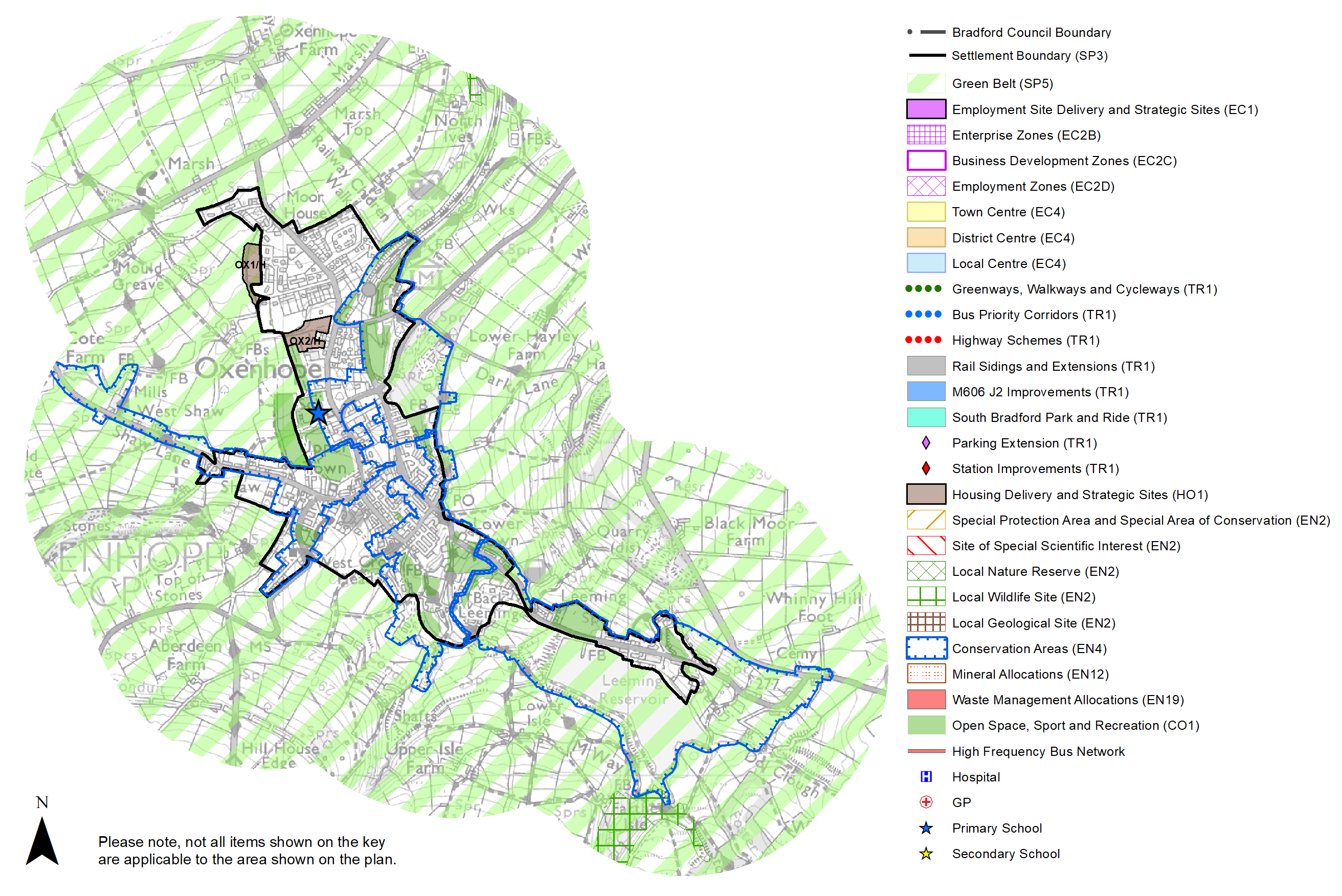
Figure 1: Location Plan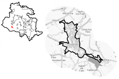
5.24.2 The settlement has a population of 1,910 and a high percentage of this (62.6%) falls within the working age category (16-64). The age profile of the settlement sees a notably higher proportion of older people (21.4%) and a slightly lower proportion of younger people (16%) compared to the West Yorkshire averages (16.7% and 20.6% respectively). A growing older population is important to consider in the future planning of the settlement in terms of housing and service provision.
5.24.3 The ethnic composition of Oxenhope is primarily made up of people who identify themselves as White British - accounting for 96.7%. This is a notably higher proportion than the West Yorkshire average (78.4%), but is similar to other smaller rural settlements in the District.
Planning for Prosperity
5.24.4 The Local Plan settlement hierarchy identifies Oxenhope as one of Bradford district's 11 Local Service Centres. This means that it will see a smaller scale of development, comprising both market and affordable housing, as well as the protection of its local centre to help ensure the continued provision of economic activity in the area.
5.24.5 No one in Oxenhope is living in the most deprived 20% of areas in England, as outlined in the Indices of Multiple Deprivation (2019).
Economy and Employment
5.24.6 Economic activity rates are relatively positive for Oxenhope with 74% of the resident population economically active compared to the West Yorkshire average (68.5%). Average household income at £42,500 is also above the West Yorkshire average (£38,499). The main employment sectors that the residents of Oxenhope work in include: health and social work, education, and retail.
5.24.7 There are now limited employment opportunities within the village with many old industrial premises now having been converted to residential use. Existing employment in the village is mainly provided through the small number of retail outlets, services, such as the Primary School and the Manorlands Hospice, as well as tourist facilities including the Keighley and Worth Valley Railway. In order to access a wider range of employment opportunities, residents need to commute to the larger centres of Bradford and Keighley, or over to Haworth or Hebden Bridge in neighbouring Calderdale.
5.24.8 Business Register and Employment Survey (BRES) data indicates that the three largest industry groups by workforce jobs (all people in employment) are: health, education, and professional, scientific and technical services.
5.24.9 The local plan does not seek to specifically allocate employment land within this Local Service Centre, but the plan is supportive of appropriately sited and scaled economic growth and diversification within the Pennine Towns and Villages.
Retail
5.24.10 The retail offer in Oxenhope is limited mainly to the Co-op (including a Post Office counter), a Pharmacy located on Station Road and a Fish and Chip shop located on Hebden Bridge Road. These retail outlets provide vital services to the local population and help to ensure Oxenhope remains a sustainable settlement. There is one public house within the centre of Oxenhope and two others which serve the Leeming area. There is no defined Local Centre within the village due to the limited number and dispersed nature of the retail outlets available.
Transport and Access
5.24.11 The A6033, Hebden Bridge Road connects Oxenhope to Haworth and Keighley to the North East and Hebden Bridge to the West. The B6141 Denholme Road/Long Causeway connects Oxenhope to Denholme and on to Bradford. As a small commuter settlement for Bradford and Keighley, these routes are important connections between Oxenhope and the larger settlements where a wider range of employment opportunities exist. Car ownership in the settlement is relatively high with around 87% of households having at least one car. This is notably higher than the West Yorkshire average (70%) and reflects the rural nature of the settlement with a more limited number of public transport options and a smaller range of retail outlets and facilities, meaning residents have to travel further to access such services.
5.24.12 Oxenhope is served by two bus services, both operated by The Keighley Bus Company (part of the Transdev Blazefield Group). The main service is the B3 Bronte Bus which provides an hourly service between Keighley and Hebden Bridge via Oxenhope. Oxenhope is also the terminus for the Keighley and Worth Valley Railway which provides journeys along the Worth Valley to Keighley. This is a heritage railway providing for the tourist market rather than a commuter service. The nearest public railway station is located in Keighley, around 7km away, which offers services to Bradford, Leeds, Skipton and further afield through transfer from these stations.
5.24.13 There are a good number of footpaths which lead out from the village in to the wider countryside and moorland, provide opportunities for walking and recreation.
5.24.14 In relation to digital accessibility, average broadband download speed in Oxenhope is around 22 megabytes per second which is below the West Yorkshire average of 44.57. There are 47 premises where speeds are below the Universal Service Obligation (USO)[1].
Planning for Homes
5.24.15 There are 857 dwellings within the settlement area. A large proportion of these are owner occupied (82.7%) which is notably higher than both the West Yorkshire (63.4%) and England (64.1%) averages. Of the remaining properties, around 14.5% are privately rented, and 3% are socially rented.
5.24.16 The existing housing mix within the village consists of older terraced housing and cottages (49%) in the central areas around the historic core, with larger more suburban housing made up of detached (24%) and semi-detached (23%) properties to the north where the village expanded in the mid-late twentieth century. A number of mill conversions have also occurred in recent years as previous industrial premises became vacant. The conversion of these buildings provides for their sustainable reuse and offers an alternative housing type in the settlement.
5.24.17 The average house price in Oxenhope for all types of housing stands at £254,444, which is significantly greater than the West Yorkshire average of £183,194. The average house prices for each house type in Oxenhope is detailed in Figure 2 below.
Figure 2: Oxenhope – House Prices
|
Average house price (all types of housing) (Land registry Sept-19 to August-20) |
Average house price (detached) (Land registry Sept-19 to August-20) |
Average house price (flats) (Land registry Sept-19 to August-20) |
||
|
£254,444 |
£360,300 |
|||
|
West Yorkshire average = £183,194 |
West Yorkshire average = £324,872 |
West Yorkshire average = £128,299 |
||
|
Average house price (semi-detached) (Land registry Sept-19 to August-20) |
Average house price (terraced) (Land registry Sept-19 to August-20) |
Households in Council Tax Band A (Valuation Office Agency (VOA) 2020) |
||
|
£226,857 |
£167,900 |
213 |
||
|
West Yorkshire average = £178,439 |
West Yorkshire average = £132,430 |
24.3% (West Yorkshire average = 43.1%) |
||
|
Households in Council Tax Band B (VOA 2020) |
Households in Council Tax Band C (VOA 2020) |
Households in Council Tax Band F-H (VOA 2020) |
||
|
165 |
165 |
92 |
||
|
18.9% (West Yorkshire average = 20.2%) |
18.9% (West Yorkshire average = 17.6%) |
10.5% (West Yorkshire average = 4.3%) |
5.24.18 The high average house price and low amounts of social housing in the settlement highlights the potential affordability issues in Oxenhope. The village is within Zone 2 in terms of the housing value areas in the District and therefore would see a requirement of 20-25% affordable housing on new developments.
5.24.19 The delivery of new housing is a key part of the development strategy for Oxenhope. This will ensure that the housing needs of local people can be met, both in terms of market and affordable housing. New housing will also allow for the modest growth of the settlement, to attract new residents and to help sustain the provision of services and facilities.
5.24.20 Policy SP8 in the local plan sets out a minimum requirement of 25 dwellings to be delivered in Oxenhope during the plan period. These will be delivered through a mix of committed sites (those under construction or have planning permission but have not yet commenced), and allocations. Table 1 below sets out the housing position for Oxenhope, which also includes the application of non-implementation or discount rates for planning permissions and allocations.
Table 1: Oxenhope - Summary of Housing Requirement and Supply
|
Housing Target |
25 units |
|
Carried Forward Commitments |
5 |
|
Commitment Discounted by 10% |
5 |
|
Remaining Allocation Requirement |
20 |
|
Identified Allocations |
44 |
|
Allocations Discounted by 10% |
40 |
|
Total Supply Contribution from Allocations |
40 |
5.24.21 Once the commitments are removed from the supply, this leaves a residual allocation requirement of 20 units. The evaluated total site supply of housing units from the preferred allocation sites equates to 44 units, which is in turn discounted by 10% for non-implementation or under delivery, leaving a final allocation contribution of 40 units. Although this figure is above the residual allocation requirement, it in part reflects the indicative site yields of the identified sites (which may be reduced once further detailed assessments have been carried out), and provides a level of flexibility in terms of the delivery of new housing within Oxenhope and the wider sub-area.
5.24.22 One Greenfield site within the settlement and one Green Belt site have been identified as the preferred housing options for Oxenhope to meet the housing requirement. In delivering the target for new homes in Oxenhope it has been necessary to make some changes to the adopted green belt. Policy SP5 sets out The Councils approach and justification for green belt releases to accommodate new development and lists the sites proposed for allocation which current lie within or partly within the green belt. Further information on these allocations is set out in Table A and identified on the Policies Map and the Site Pro Formas below together with the local strategies map for each plan area. Development of site allocations should be in accordance with specified development guidelines and approximate site provision figures and all other relevant policies of this Local Plan. The Council will be supportive of additional proposals for new homes on additional small sites, particularly those that provide a redevelopment opportunity to bring forward land which has been previously used. Support will also be provided to developers who wish to redevelop larger sites and/or buildings for new homes not currently identified, subject to all relevant policies in the Local Plan.
Planning for Places and Communities
Green Belt, Natural Landscape and Historic Character
5.24.23 Similar to the other villages in the South Pennines, Oxenhope is surrounded by Green Belt which forms a tight boundary with the built-up area.
5.24.24 The main landscape character type to the East and West and of the village is Mixed Upland Pasture. This landscape consists of larger fields enclosed by dry stone walls and contains a high density of traditional gritstone farmsteads. With a strong character, high historic continuity and visual prominence, this landscape is sensitive to further development. There are also two areas of Wooded Valley landscape, one to the south of Leeming and one to the northeast of Oxenhope which connects the village with Haworth. This landscape consists of narrow bands of woodland which follow the routes of Nan Scar Beck and Bridgehouse Beck. Again this landscape is strong-moderate in character, has high historic continuity and is moderately sensitive to change.
5.24.25 There are four separate designated Conservation Areas within Oxenhope, covering the area around the Station, the upper and lower town areas and also Leeming. This reflects the rich historic development of the settlement and this is further acknowledged through the 44 Grade II listed buildings which are present within the village. The development and expansion of Oxenhope came about through the cloth and wool trade in the early to mid-19th Century, and saw the construction of a number of mills. The Keighley and Worth Valley Heritage Railway terminates in Oxenhope and is another key heritage asset in the village that should be protected. In terms of other heritage designations, there are no scheduled monuments or known archaeological sites within or immediately adjacent to the village.
Green Infrastructure, Ecology, Open Space and Flood Risk
5.24.26 A large part of Oxenhope falls within the District's Green Infrastructure (GI) Corridors. These corridors are formed of a network of green space sites and waterbodies. In Oxenhope they run from north to south following the line of Leeming Water/Bridgehouse Beck, and from East to West following the line of Moorhouse Beck. These areas are multi-functional in nature and help to deliver benefits for biodiversity, reduce flood risk, provide public rights of way, and areas of open space. These corridors should be protected and enhanced, and new developments should identify the opportunities to connect into these networks by enhancing natural features that exist on-site and improving the links between sites. Figure 3 shows the location of these corridors.
Figure 3: Green Infrastructure Corridors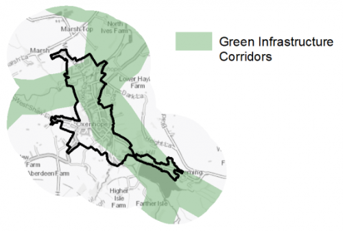
5.24.27 There are no designated Local Wildlife Sites or Local Natural Reserves within the settlement limits. However, there are a number of wildlife assets surrounding the settlement with areas of land forming a Wildlife Habitat Network running all the way along the eastern edge of the village. There are also other wildlife networks which run out from the western and south edges, of particular note are the grassland and woodland habitats which follow the route of Paul Clough and Nan Scar Beck. These networks provide important corridors to allowing species movement and migration, and many of these areas are also identified as important priority habitats.
5.24.28 The South Pennine Moors SPA/SAC is situated close by, to the west meaning that Oxenhope falls within the 2.5km zone of this Internationally designated wildlife habitat. This zone has been identified as the area most frequently utilised by SPA qualifying species for foraging. As such, any development will be required to carry out an HRA to ensure there are no significant effects on the protected sites in terms of impact on supporting habitat which might be functionally linked to the SPA and recreational pressures.
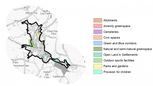
5.24.29 There are 26 open space sites of various types within the settlement which cover a total area of 11.89ha. This represents a good level of provision compared to the size of the population. Key sites include the Oxenhope Millennium Green, the cricket ground, and playing fields (off Shaw Lane). There are only a few very small deficits in a number of typologies. Additional provision of outdoor sports space should be prioritised, but on the whole Oxenhope is generally well served by the existing open space provision. Figure 4 shows the type and location of open space in Oxenhope.
Figure 4: Oxenhope – Open Space Overview
5.24.30 The village is located within a valley and development has occurred along the line of Leeming Water/Bridgehouse Beck, and to a lesser extent around Moorhouse Beck. Some parts of the settlement are therefore at risk of fluvial flooding from these watercourses. There are also some significant areas at risk of surface water flooding. This is particularly prevalent along the small tributaries which run into the main watercourses. Any development likely to be affected by flood risk will need to undertake the necessary assessments and put in place any relevant mitigation.
Community Infrastructure – Education, Health and Utilities
5.24.31 Oxenhope has a limited number of community facilities available to meet the day to day needs of local people. The village benefits from a Community Centre located off Shaw Lane which is run by a volunteer community association and offers a venue for events and other community activities. The village also has a local shop (including post office), fish and chip shop, places of worship and public houses.
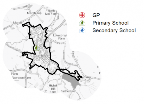
5.24.32 Oxenhope C of E Primary School is a single form entry voluntary aided school located off Hebden Bridge Road. The nearest secondary provision is found around 5km at Parkside School in Cullingworth.
5.24.33 There is no GP surgery in Oxenhope with residents relying on practices in either neighbouring Haworth or Denholme to access Primary Care Services. However, there is a Pharmacy within the village allowing residents to pick up prescriptions and the purchase of over the counter medicines. Secondary (acute) healthcare is provide at either Bradford Royal Infirmary or Airedale General, both around 10km away from the village. Figure 5 shows the location of the primary school.
Figure 5: Oxenhope – Schools and GP Practices
5.24.34 When planning for the long-term development of Oxenhope, it is vital that new development is supported by the appropriate infrastructure. The capacity, quality and accessibility of services and facilities are all key components in ensuring people can enjoy living, working and visiting the area. The Council will continue work with key infrastructure providers and others including the Local Education Authority, Clinical Commissioning Group and utilities providers to determine the impacts of future growth and development on local infrastructure capacity and provision. Further infrastructure details will be published through the Local Infrastructure Plan and as part of the Regulation 19 stage of the local plan.
|
Local Area Strategy and Plan – Oxenhope The key elements for the local strategy area of Oxenhope include:
|
(12) Consultation Question 134
Oxenhope Local Area Strategy
The Local Plan sets out a local area strategy for Oxenhope.
Q.Please provide any comments you may have on the area strategy?
If you have an alternative to the approach undertaken, please provide further details and evidence in support.
Preferred Site Allocations and Site Pro Formas
5.24.35 The preferred housing site allocations are detailed below in Table A. This table is subsequently followed by site pro formas providing a summary of key site information and characteristics.
Table A: Housing - Preferred Allocations
|
Site Ref |
Site Name |
Dwellings |
|
OX1/H |
Crossfield Road |
20 |
|
OX2/H |
Cross Lane |
24 |
|
Total |
44 |
(6) Consultation Question 135
Oxenhope Site Allocation and Site Pro Forma
The Local Plan sets out a preferred site allocation for Oxenhope. If you wish to make representations on the site proposed, please provide feedback under this question.
If you wish to propose an additional or alternative site(s) to the preferred allocation listed, please also provide a plan with a red line and any further details in support.
[1] Universal Service Obligation (USO) - download speeds at or above 10Mbit/s and upload speeds at or above 1Mbit/s including non-matched records and zero predicted speeds
(32) OX1/H - Crossfield Road
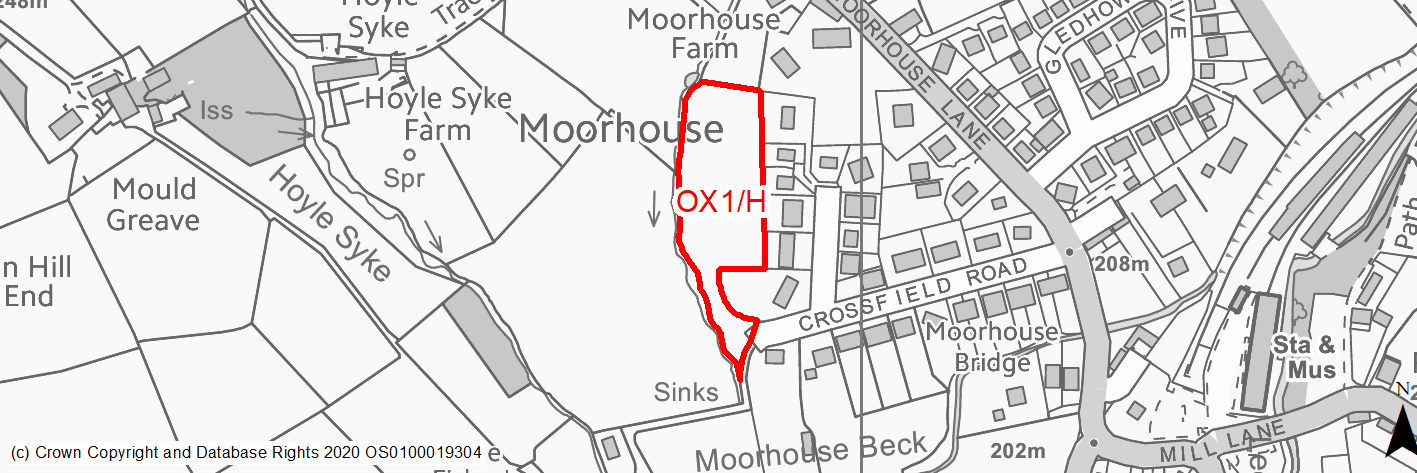
Site location
Local Service Centre - Oxenhope
Ward
Worth Valley Ward
Site description
This site is an enclosed field with areas of vegetation. The site is relatively level with a slight slope down hill from north to south. The boundaries of the site are formed of dry stone walls, fences, the rear gardens of properties on Crossfield Close and Moorhouse Lane and a small watercourse which runs along the western edge.
Proposed Allocation
Housing
SHLAA referencce
OX/003
Indicative no. dwellings
20
Site area (Gross) (ha)
0.69
Ownership
Private
Delivery timescales
Developable (6-10 years)
Type (PDL/Greenfield)
Greenfield
Green Belt
Yes
Flood Zone
Flood Zone 1
Potential site access
There is an existing access into the site through a field gate at the end of Crossfield Road. This is an unadopted section of road that would need to be widened and made up to adotpable standards.
Public Transport Accessibility
Site within 400m of a bus stop but only an hourly service.
Sustainability Appraisal
Approximately 40% of the site is at risk of surface water flooding, including areas of high and medium risk. Given the relatively small size of the site it may be difficult to entirely avoid this area, and therefore a major adverse effect has been predicted for the climate change resilience SA Objective.
Minor positive effects were predicted for a range of socio-economic themed SA Objectives due to the benefits of new residential development for the local economy as well as the location of the site in relation to transport links, local services and amenities, education facilities and employment areas. However, the village of Oxenhope does not have a medical centre, meaning access to health facilities for residents at the site would be somewhat limited.
As a large greenfield and Green Belt site adjacent to TPO woodland, the development has been predicted to result in minor adverse effects on most natural environment themed SA Objectives. There is a small stream to the western perimeter, which could be impacted by construction and occupation of the site. 60m north-east of the site are two Grade II Listed Buildings, the settings of which could be adversely affected by development here.
Habitats Regulations Assessment
This site falls within 2.5km of the South Pennine Moors SPA/SAC a HRA must be undertaken to ensure there are no significant effects on these protected sites in terms of impact on supporting habitat which might be functionally linked to the SPA and recreational pressures. Developments within these zones must comply with Policy SP11; an SPD is being produced to provide further guidance.
Green Belt
Based on planning judgement the site has a moderate potential impact on the Green Belt.
• The site is in a moderate performing Green Belt parcel.
• The site makes a moderate contribution to the purposes of including land in the Green Belt.
• The site has a moderate potential for sprawl and would have a moderate impact on the openness of the Green Belt.
• The site presents the opportunity to create a stronger Green Belt boundary than that of the existing one.
Constraints and Opportunities
• The site is currently designated as Green Belt, and the site specific Green Belt assessment indicates that it has a moderate potential impact.
• Access into the site would need to be improved to adoptable standards.
• The site is located within the 2.5km buffer of the SPA/SAC.
Development considerations
• Provision of compensatory improvements to the surrounding Green Belt which may include enhancement of adjacent public rights of way or provision of additional connection, and enhancement of the adjacent biodiversity assets, particularly the stream to the west of the site.
• Access off Crossfield Road needs to be improved to adoptable standards.
• Ecological survey to identify any impacts and mitigate accordingly.
Conclusion/Summary
This site is sustainably located adjacent to the settlement boundary and provides a suitable extension to the urban area, being contained by properties on Crossfield Close and the beck to the west. It would deliver an estimated 20 dwellings.
(58) OX2/H - Cross Lane
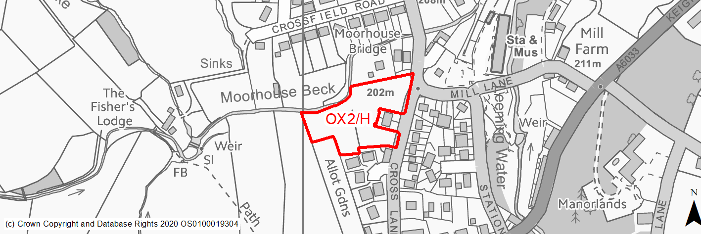
Site location
Local Service Centre - Oxenhope
Ward
Worth Valley Ward
Site description
This site consists of an area of agricultural land within the settlement. It is made up of grassland and lines of trees and hedgerows. It slopes gentley down hill from west to east. It is bounded by drystone walls on three sides with the extreme western boundry being undefined. The northern boundary is partly formed by Moorhouse Beck.
Proposed Allocation
Housing
SHLAA referencce
OX/014
Indicative no. dwellings
24
Site area (Gross) (ha)
0.79
Ownership
Private
Delivery timescales
Developable (6-10 years)
Type (PDL/Greenfield)
Greenfield
Green Belt
No
Flood Zone
Flood Zone 1, northern boundary within Flood Zone 2 & 3
Potential site access
There is an existing field gate access to the site off Cross Lane to the South. This access point would need to be made up to adoptable standards.
Public Transport Accessibility
Site within 400m of a bus stop but only an hourly service.
Sustainability Appraisal
A major adverse effect arises for the climate change resilience SA Objective due to the site overlapping with land in the active flood zones FZ2 and FZ3 associated with Moorhouse Beck, and a thin band in the same area at high risk of surface water flooding. More detailed flood risk assessments would likely be required for the site.
Minor positive effects were predicted for a range of socio-economic themed SA Objectives due to the benefits of new residential development for the local economy as well as the location of the site in relation to transport links, local services and amenities, education facilities and employment areas. However, the village of Oxenhope does not have a medical centre, meaning access to health facilities for residents at the site would be somewhat limited.
Minor adverse effects were predicted for a range of natural environment themed SA Objectives, primarily as a result of the impacts of new development on a 100% greenfield site overlapping TPO woodland. The western perimeter adjoins Moorhouse Beck, and construction and occupation of this site could pose a risk to the water quality. The north-eastern corner of the site adjoins the Oxenhope Station Conservation Area, the setting of which could potentially be adversely affected by development at this open greenfield site.
Habitats Regulations Assessment
This site falls within 2.5km of the South Pennine Moors SPA/SAC a HRA must be undertaken to ensure there are no significant effects on these protected sites in terms of impact on supporting habitat which might be functionally linked to the SPA and recreational pressures. Developments within these zones must comply with Policy SP11; an SPD is being produced to provide further guidance.
Green Belt
N/A – Site not within the Green Belt.
Constraints and Opportunities
• The site consists of designated village green space but there are opportunities to enhance this feature as part of development.
• There may be the risk of surface water flooding / insufficient drainage to the north of the site.
• Potential impact on the Oxenhope Station Conservation Area.
• The site is located within the 2.5km buffer of the SPA/SAC.
• The site is within very close proximity to recreation space and Oxenhope C of E Primary School.
Development considerations
• Provision of high quality public open space.
• Mitigation of surface water / drainage issues.
• Sensitive site design to mitigate any impact on the conservation area.
• Ecological survey to identify any impacts and mitigate accordingly.
• Direct vehicular and pedestrian access off Cross Lane.
Conclusion/Summary
This site is sustainably located within the settlement boundary near local services and facilities and would deliver an estimated 24 dwellings with potential enhancements to open space provision.