
Draft Bradford District Local Plan - Preferred Options (Regulation 18) February 2021
Cullingworth
Introduction
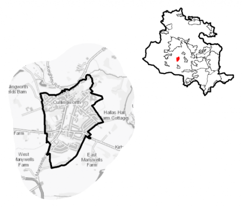
5.19.1 The village of Cullingworth is located within the South Pennine Towns and Villages sub- area of Bradford District and Bingley Rural Ward. It is located approximately 10km north west of Bradford, 3km east of Haworth and 2.5km west of Wilsden. It is largely residential in nature, with some local services; it is a commuter settlement for Bradford.
Figure 1: Location Map
5.19.2 Cullingworth has a total population of 2,937 and a high percentage of this (58.9%) falls within the working age category (16-64). The age profile of the settlement is comparable to the West Yorkshire average with a higher percentage of over 65s (22.5% compared to the sub-regional average of 16.7%). The ethnic composition of Cullingworth is primarily made up of people who identify themselves as White British - accounting for 93.8%. This is a notably higher proportion than the West Yorkshire average (78.4%), but is similar to other smaller rural settlements in the District.
Planning for Prosperity
5.19.3 The Local Plan settlement hierarchy identifies Cullingworth as one of the district's 11 Local Service Centres. This means that it will see a smaller scale of development, comprising both market and affordable housing, as well as the protection of its local centre to help ensure the continued provision of economic activity in the area.
Economy and Employment
5.19.4 Economic activity rates are around average for Cullingworth with 69.9% of the resident population economically active compared to the West Yorkshire average (68.5%). Average household income at £39,400 is just slightly higher than the West Yorkshire average (£38,499). The main employment sectors that the residents of Cullingworth work in include retail, health and social work and education.
5.19.5 There are some employment opportunities within the village itself following the closure of many of the industrial and manufacturing businesses in recent years. Existing employment is mainly made up of the village's abattoir, builder's merchants, retail outlets and the service economy e.g. the local primary and secondary schools.
5.19.6 There are no longer any designated employment areas within the village. In order to access a wider range of employment opportunities, residents need to commute to the larger centres of Bradford, Keighley and Halifax.
5.19.7 Business Register and Employment Survey (BRES) data indicates that the three largest industry groups by workforce jobs (all people in employment) are: education (25.9%), manufacturing (20%) and construction (11.6%).
5.19.8 The local plan does not seek to specifically allocate employment land within this Local Service Centre, but the plan is supportive of appropriately sited and scaled economic growth and diversification within the Pennine Towns and Villages.
Retail
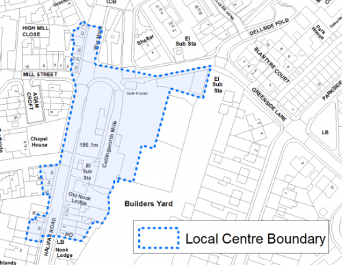
5.19.9 The Retail and Leisure Study (2019) concluded that Cullingworth functions well as a local centre with a good range of convenience and essential day-to-day uses, with the new Co-op anchoring the centre. Facilities in Cullingworth include a convenience store, newsagent, butcher, a pharmacy, post office, florist, furniture store, antiques centre, tea room, takeaway restaurants and hairdressers. The boundary of the local centre is identified in figure 2 below.
Figure 2: Cullingworth Local Centre
Transport and Access
5.19.10 Cullingworth lies on the cross roads of the B6429 Halifax Road and the B6144 Haworth Road. The A629 Keighley/Halifax Road is located to the south west of the village which provides access to Denholme, Bradford and Keighley. There are frequent bus services to Keighley and Bradford along with an hourly service to Halifax.
5.19.11 The nearest railway stations are each around 5km away, these are Bingley, Crossflatts and Keighley. Leeds Bradford International Airport is 15 km away.
5.19.12 The Great Northern Railway Trail and National Cycle Network route 69 which, though disjointed, provides a link between Cullingworth and Queensbury and provides a local tourist attraction.
5.19.13 In relation to digital accessibility, average broadband download speed in Cullingworth is almost 27 megabytes per second which is significantly below the West Yorkshire average of 44.57. There are no premises where speeds are below the Universal Service Obligation (USO)[1].
Planning for Homes
5.19.14 Cullingworth has 1,371 dwellings which are mostly owner occupied (72%), this is higher than the regional average (63.4%). Just 13% are socially rented compared to the regional average of 19%. There is mix of house types in Cullingworth with the highest proportion being mainly older terraced properties located around the north-east of the settlement (35%), semi-detached (36%) and detached (18%) properties being the dominant dwelling type in the newer housing estates which surround the historic core.
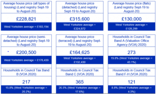
Around half of the village's houses were built between 1945 and 1999. The average house price in Cullingworth has increased recently to £228,821 (2020), partly due to the delivery of new homes on the former Manywells industrial site making prices now significantly above regional averages (£183,194). This would equate to an income multiplier of 5.44.
Figure 3: Cullingworth – House Prices
5.19.15 The delivery of new housing is a key part of the development strategy for Cullingworth. This will ensure that the housing needs of local people can be met, both in terms of market and affordable housing. New housing will also allow for the modest growth of the settlement, to attract new residents and to help sustain the provision of services and facilities.
5.19.16 Policy SP8 in the local plan sets out a minimum requirement of 175 dwellings to be delivered in Cullingworth during the plan period. These will be delivered through a mix of committed sites (those under construction or which have planning permission but have not yet started) and allocations. Table 1 below sets out the housing position for Cullingworth, which also includes the application of non-implementation or discount rates for planning permissions and allocations.
Table 1: Cullingworth - Summary of Housing Requirement and Supply
|
Housing Target |
175 units |
|
Carried Forward Commitments |
71 |
|
Commitment Discounted by 10% |
64 |
|
Remaining Allocation Requirement |
111 |
|
Identified Allocations |
135 |
|
Allocations Discounted by 10% |
122 |
|
Total Supply Contribution from Allocations |
122 |
5.19.17 Once the commitments are discounted and removed from the supply, this leaves a residual allocation requirement of 111 units. The evaluated total site supply of housing units from the preferred allocation sites equates to 135 units, which is in turn discounted by 10% for non-implementation or under delivery, leaving a final allocation contribution of 122 units.
5.19.18 A portfolio of three sites have been identified as the preferred set of site options for Cullingworth to meet the housing the requirement. These consist of the brownfield sites at Cullingworth Mill, the former railway station / industrial site off Halifax Road and a Green Belt site to the east of the village on Cullingworth Road. Further information on these proposed allocations is set out in Table A and identified on the Policies Map and in the Site Pro Formas below, together with the local strategies map for each plan area. In delivering the target for new homes in Cullingworth it has been necessary to make some changes to the adopted green belt. Policy SP5 sets out the Councils approach and justification for green belt releases to accommodate new development and lists the sites proposed for allocation which current lie within or partly within the green belt. The Council will be supportive of additional proposals for new homes on additional small sites, particularly those that provide a redevelopment opportunity to bring forward land which has been previously used. Support will also be provided to developers who wish to redevelop larger sites and/or buildings for new homes not currently identified, subject to all relevant policies in the Local Plan. Development of site allocations should be in accordance with specified development guidelines and approximate site provision figures and all other relevant policies of the Local Plan.
Planning for Places and Communities
Green Belt, Natural Landscape and Historic Character
5.19.19 Cullingworth village is surrounded by Green Belt land which is also within the Wilsden Landscape Character Area. The landscape is predominately Mixed Uplands Pasture, with a small section of Enclosed Pasture to the north western corner of the village along with Wooded Valley to the far north. The majority of this landscape is considered to be of medium sensitivity, whereas land to the west and northern corner is not as sensitive to change.
5.19.20 The historic core of Cullingworth village lies to the north and is designated as a Cullingworth Conservation Area. The majority of Cullingworth's 22 Grade II Listed Buildings are located within the Conservation Area, Including St. Johns Church and Manor Farm and Cottage.
Green Infrastructure, Ecology, Open Space and Flood Risk
5.19.21 Green Infrastructure areas which cover Cullingworth running north to south and branching off to the west form part of the District's Green Infrastructure network and should be protected and enhanced. These areas are multi-functional in nature and help to deliver benefits for biodiversity, reduce flood risk, provide public rights of way, and areas of open space. New developments should identify the opportunities to connect into these networks by enhancing natural features that exist on-site and improving the links between sites.
5.19.22 Cullingworth has a number of biodiversity designations within or adjoining the village area. A habitat network comprising Lowland mixed deciduous woodland & scrub runs along the route of the Great Northern Railway Trail, which passes through the settlement. Priority Habitats include deciduous woodland, located within and around Cullingworth, and semi-improved neutral grassland to the east and south of the settlement. There are five Local Wildlife Sites (LWS) located around the settlement (within 1 km) to the south of the settlement there is Black Moor and Milking Hole Beck and Hewenden Reservoir, Hewenden Wood and Goitstock Wood and Grasslands LWSs lie to the east and Dowdy Wood LWS is to the north-west. Goitstock Waterfall, Cullingworth Local Geological Site is also located to the west of Cullingworth.
5.19.23 The South Pennine Moors SPA (and SSSI) is located 3.2km form the settlement's western boundary and therefore Cullingworth falls within the 7km zone of this Internationally designated wildlife habitat. Within this zone new developments will need to contribute to measures to mitigate against the potential increased recreational impact of the increase in population.
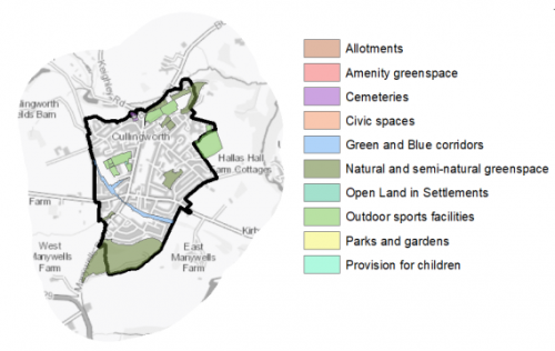
5.19.24 Key open spaces within the settlements are Cullingworth Recreation Ground, Cullingworth Cricket Club Ground, Manywells Quarry and the Great Northern Railway Trail. These sites provide a key role in connecting the settlement in terms of green infrastructure corridors but also for leisure and recreation. Cullingworth does not currently have any allotment provision, which may be expected in a settlement of this size. Figure 4 illustrates the location and type of open spaces in the village.
Figure 4: Cullingworth – Open Space Overview
5.19.25 There are a number of becks (Manywells, Cow House and Ellar Carr) to the north of the settlement which could suffer from fluvial flooding and are in Flood Zone 2. Manywells Beck feeds into the historic core of the village, passing through a culvert under Cullingworth Mill and through the centre of the settlement, adjacent Halifax Road. Subsequently, this area has quite high potential for surface water flooding which will need to be a development consideration. There are other parts of the settlement, particularly along main roads where there is potential for surface water flooding to occur due to the topography and permeability of surfaces in that area.
Community Infrastructure – Education, Health and Utilities
5.19.26 There are numerous community facilities in Cullingworth. Cullingworth Village Hall is located towards the north of the settlement; it is a modern building with community space, classes and a cafe. There are two churches in the villages, St. John the Evangelist and Cullingworth Methodist Church.
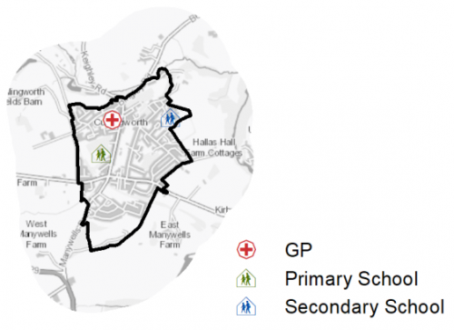
5.19.27 Cullingworth Village Primary School has a capacity of 300; it is located off Halifax Road in the centre of Cullingworth. Secondary location is provided at Parkside School, in the west of Cullingworth, which has a capacity of 1,113.
5.19.28 The village is served by one medical facility, Cullingworth Medical Practice which is part of Wilsden Medical Practice, which in total serves around 10,000 patients and provides a service to residents of Cullingworth, Wilsden, Denholme and Harden. There is a pharmacy located on Halifax Road. Local services are identified in figure 5 below. Secondary (acute) healthcare is provided at Bradford Royal Infirmary and Airedale General Hospital.
Figure 5 Cullingworth – Schools and GP Practices
5.19.27 When planning for the long-term development of Cullingworth, it is vital that new development is supported by the appropriate infrastructure. The capacity, quality and accessibility of services and facilities are all key components in ensuring people can enjoy living, working and visiting the area. The Council will continue work with key infrastructure providers and others including the Local Education Authority, Clinical Commissioning Group and utilities providers to determine the impacts of future growth and development on local infrastructure capacity and provision. Further infrastructure details will be published through the Local Infrastructure Plan and as part of the Regulation 19 stage of the local plan.
|
Local Area Strategy and Plan – Cullingworth The key elements of the local strategy for Cullingworth include:
|

(7) Consultation Question 124
Local Area Strategy and Plan – Cullingworth
Q. Please provide any comments you may have on the area strategy?
If you have an alternative to the approach undertaken, please provide further details and evidence in support.
Preferred Site Allocation and Site Pro Forma
5.19.28 The preferred housing site allocation is detailed below in Table A. This table is subsequently followed by site pro forma providing a summary of key site information and characteristics.
Table A: Cullingworth Housing Sites - Preferred Allocations
|
Site Ref |
Site Name |
Dwellings |
|
CU1/H |
Halifax Road |
53 |
|
CU2/H |
Cullingworth Mill |
48 |
|
CU3/H |
Cullingworth Road / Doll Lane |
34 |
|
Total |
135 |
(6) Consultation Question 125
Cullingworth- Site Allocations and Site Pro Formas
The Local Plan sets out a preferred site allocation for Cullingworth. If you wish to make representations on the site proposed, please provide feedback under this question.
If you wish to propose an additional or alternative site(s) to the preferred allocation listed, please also provide a plan with a red line and any further details in support.
[1] Universal Service Obligation (USO) - download speeds at or above 10Mbit/s and upload speeds at or above 1Mbit/s including non-matched records and zero predicted speeds
(3) CU1/H - Halifax Road
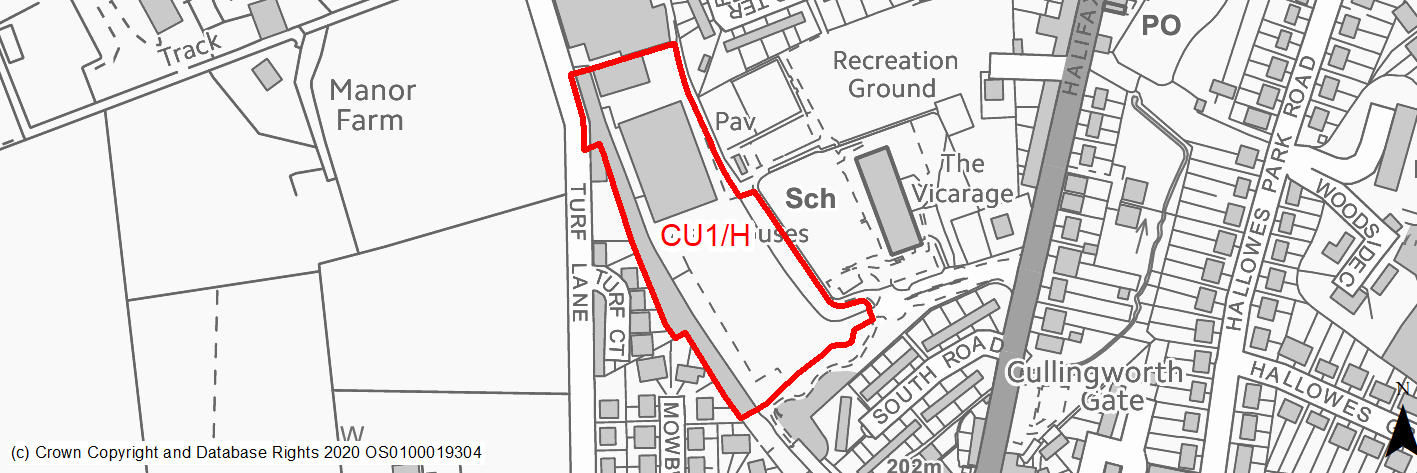
Site location
Local Service Centre - Cullingworth
Ward
Bingley Rural Ward
Site description
Former railway station and associated goods yard. After the station closing in 1955 industrial warehouses were built onsite. Site has been derelict and has hardstandings, foundations and rememants of buildings along with early successional habitat. The site is within the settlement and surrounded by a school, residential, industrial (poultry) and recreational uses. It can be accessed from New School Lane.
Proposed Allocation
Housing
SHLAA referencce
CU/001
Indicative no. dwellings
53
Site area (Gross) (ha)
1.86
Ownership
Private
Delivery timescales
Deliverable (0-5 years)
Type (PDL/Greenfield)
PDL
Green Belt
No
Flood Zone
Flood Zone 1
Potential site access
Access can be achieved form New School Lane which incorporates a roundabout at the junction insitu.
Public Transport Accessibility
Bus stop within 400m with frequent service.
Sustainability Appraisal
The site could deliver major positive effects for residents on both the health and education SA Objectives as a result of being within the target distances for all necessary health facilities and centres for primary and secondary education.
Minor positive effects were predicted for nearly all other socio-economic themed SA Objectives due to the benefits of new residential development for the local economy as well as the location of the site in relation to transport links, local services and amenities, and employment areas.
As a PDL site, there are opportunities here for achieving biodiversity net gains and enhancing the local townscape character, depending on the design and implementation of the development.
No major adverse effects have been predicted for the site, but there is a very limited extent of land at a low, medium and high risk of surface water flooding along the south-western perimeter, though this is expected to be avoided through a careful layout. The only other minor adverse effects are related to increases in air pollution and water consumption, which have been predicted at nearly all sites.
Habitats Regulations Assessment
This site falls within 7km of the South Pennine Moors SPA/SAC. A HRA must be undertaken to ensure there are no significant effects on these protected sites. Developments within these zones must comply with Policy SP11; a SPD is being produced to provide further guidance.
Green Belt
N/A – Site not within the Green Belt.
Constraints and Opportunities
• Lowland mixed deciduous woodland & scrub woodland habitat runs along western edge of site.
• Adjacent semi-natural green space.
• Access can be achieved from New School Lane.
• Sandstone Minerals Safeguarding Area.
• Good public transport connections.
• The site is located within the 7km buffer of the SPA/SAC.
• Within the Great Northern Trail & Shibden GI corridor.
Development considerations
• Access road incroporates a pick up and drop off area for the local school, may include buses turning, public safety will need to be prioritised.
• A sensitive site design will be required to mitigate any impact on the surrounding Green Infrastructure corridor.
Conclusion/Summary
Site has outline planning permission and pre-application discussions regarding reserved matters are underway. The site is previously developed land within the settlement and in a sustainable location.
(5) CU2/H - Cullingworth Mill
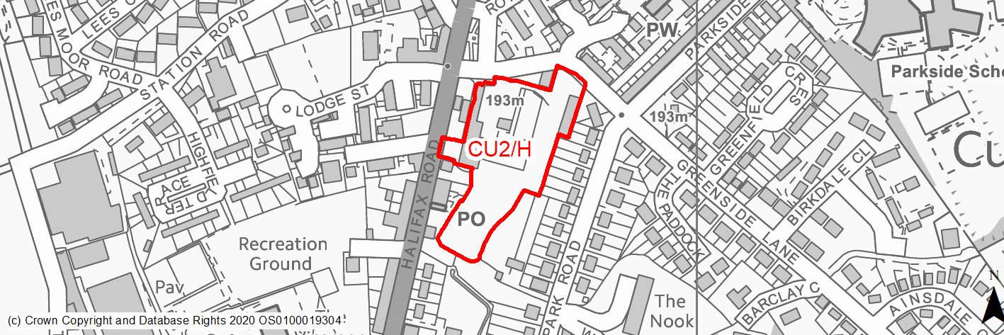
Site location
Local Service Centre - Cullingworth
Ward
Bingley Rural Ward
Site description
Part derelict Industrial site used as retail and builders yard in the centre of Cullingworth. The mill buildings and entrance portal distinctive features to the village. Significant level of surface water risk throughout site.
Proposed Allocation
Housing
SHLAA referencce
CU/004
Indicative no. dwellings
48
Site area (Gross) (ha)
1.15
Ownership
Private
Delivery timescales
Developable (6-10 years)
Type (PDL/Greenfield)
PDL
Green Belt
No
Flood Zone
Flood Zone 1
Potential site access
Potentially existing access through arch - though narrow and close to junction.
Public Transport Accessibility
Bus stop adjacent site with frequent service.
Sustainability Appraisal
The site could deliver major positive effects for residents on both the health and education SA Objectives as a result of being within the target distances for all necessary health facilities and centres for primary and secondary education.
A major adverse effect arises for the climate change resilience SA Objective due to a large area of land in the centre of the site at a high risk of surface water flooding. Given the number of dwellings proposed, it is unlikely that it would be possible to avoid this.
Minor positive effects were predicted for nearly all other socio-economic themed SA Objectives due to the benefits of new residential development for the local economy as well as the location of the site in relation to transport links, local services and amenities, and employment areas.
Cullingworth Conservation Area is 30m north-west of the site and there are two Grade II Listed Buildings within 40m, and given the current condition of the PDL site, new development here could enhance the setting of these heritage assets, as well as provide opportunities to achieve biodiversity net gains and improve the local townscape character.
The only other adverse effects are minor and related to increases in air pollution and water consumption, which have been predicted at nearly all sites.
Habitats Regulations Assessment
This site falls within 7km of the South Pennine Moors SPA/SAC. A HRA must be undertaken to ensure there are no significant effects on these protected sites. Developments within these zones must comply with Policy SP11; a SPD is being produced to provide further guidance.
Green Belt
N/A – Site not within the Green Belt.
Constraints and Opportunities
• Significant surface water flooding issues, all of south site and large portion of centre are 1 in 30.
• Adjacent Grade II Listed Building. Principal mill building could be regarded as undesignated heritage asset.
• Potentially existing access through arch - though narrow and close to junction. Pedestrian access may be an issue as existing access very narrow - no existing footpath.
• Sandstone Minerals Safeguarding Area.
• Good public transport connections.
• The site is located within the 7km buffer of the SPA/SAC.
• Within the Great Northern Trail & Shibden GI corridor.
Development considerations
• Surface water flooding mitigation would be needed and may significantly constrain the site, would benefit fronm further SFRA consideration, culvert under site could potentionally be reconfigured.
• Bat alert area, developable but ecological surveys required after allocation.
• Existing heritage assests including entrance arch would need to be considered and potentially incoporated into the design.
Conclusion/Summary
The site is in a highly sustainable location within the centre of the settlement. However there are significant challenge in terms of surface water flooding and access. Heritage will also need to be considered. Further investigation will be required to ensure the viability of the site.
(7) CU3/H - Cullingworth Road/Doll Lane
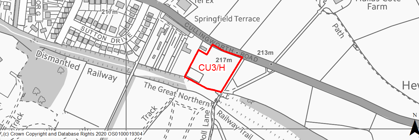
Site location
Local Service Centre - Cullingworth
Ward
Bingley Rural Ward
Site description
The site is in the green belt and adjoins the eastern urban edge of the village. The dismantled railway footpath runs along the southern boundary, forms part of a wildlife corridor. To the east is open countrsyide and a hill which limits views into the settlement. Access can be taken from Cullingworth Road. Site includes detached house, stables and pasture.
Proposed Allocation
Housing
SHLAA referencce
CU/013
Indicative no. dwellings
34
Site area (Gross) (ha)
0.72
Ownership
Private
Delivery timescales
Developable (6-10 years)
Type (PDL/Greenfield)
Greenfield
Green Belt
Yes
Flood Zone
Flood Zone 1
Potential site access
Access via existing access into car parking area for stables off Cullingworth Road.
Public Transport Accessibility
Bus stop within 400m but only hourly service.
Sustainability Appraisal
The site could deliver a major positive effect for residents on the education SA Objective as a result of being within the target distance for both primary and secondary education facilities.
Minor positive effects were predicted for most socio-economic themed SA Objectives due to the benefits of new residential development for the local economy as well as the location of the site in relation to transport links, health facilities and employment areas.
No major adverse effects have been predicted for the site, but minor adverse effects were predicted for a range of natural environment themed SA Objectives, primarily as a result of the impacts of new development on a greenfield and Green Bbelt site.
Habitats Regulations Assessment
This site falls within 7km of the South Pennine Moors SPA/SAC. A HRA must be undertaken to ensure there are no significant effects on these protected sites. Developments within these zones must comply with Policy SP11; a SPD is being produced to provide further guidance.
Green Belt
Based on planning judgement the site has a moderate potential impact on the Green Belt.
• The site is in a low performing Green Belt parcel.
• The site makes a moderate contribution to the purposes of including land in the Green Belt.
• The site has a moderate potential for sprawl and would have a moderate impact on the openness of the Green Belt.
• The site presents the opportunity to create a stronger Green Belt boundary than that of the existing one with an adjustment to the inner green belt to the west of the site.
Constraints and Opportunities
• Woodland habitat runs along southern boundary.
• Development of the site would have a moderate impact on the landscape.
• Access via existing access into car parking area for stables off Cullingworth Road.
• Poor public transport connections.
• The site is located within the 7km buffer of the SPA/SAC.
• Within the Great Northern Trail & Shibden GI corridor.
Development considerations
• Although a gateway site and quite elevated, it is semi screened on several sides. There are FP receptors but few residential ones, a sensitive site design will be required to mitigate any impact on the surrounding landscape and Green Infrastructure corridor.
• The site is adjacent to priority woodland and the habitat network and a buffer would be expected on the southern edge with habitat to enhance the woodland.
Conclusion/Summary
This is a flat site, quite sustainably located adjacent to the settlement boundary and is contained on one side by existing residential development. It is fairly well contained but does have long ranging views out of the site.