
Draft Bradford District Local Plan - Preferred Options (Regulation 18) February 2021
Bradford South East
Introduction
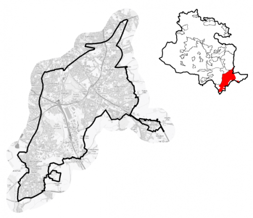
5.3.1 The Local Plan settlement hierarchy identifies Bradford South East as one of four quadrant areas within the wider Regional City of Bradford. It is broadly defined by the extended (Southern Gateway) Bradford City Centre boundary to the north and to the Leeds Road in the north east of the area, A641 Manchester Road to the west, and Green Belt land to the east and south. It covers an area of approximately 1,747 hectares and contains a diverse range of residential areas plus some of the Bradford's prime industrial and business areas with good connectivity to the M606 and west Leeds.
5.3.2 Bradford South East includes the wards of Tong, majority of Wyke, about half of Little Horton and a small element of Wibsey Ward plus a large proportion of Bowling and Barkerend Ward.
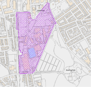
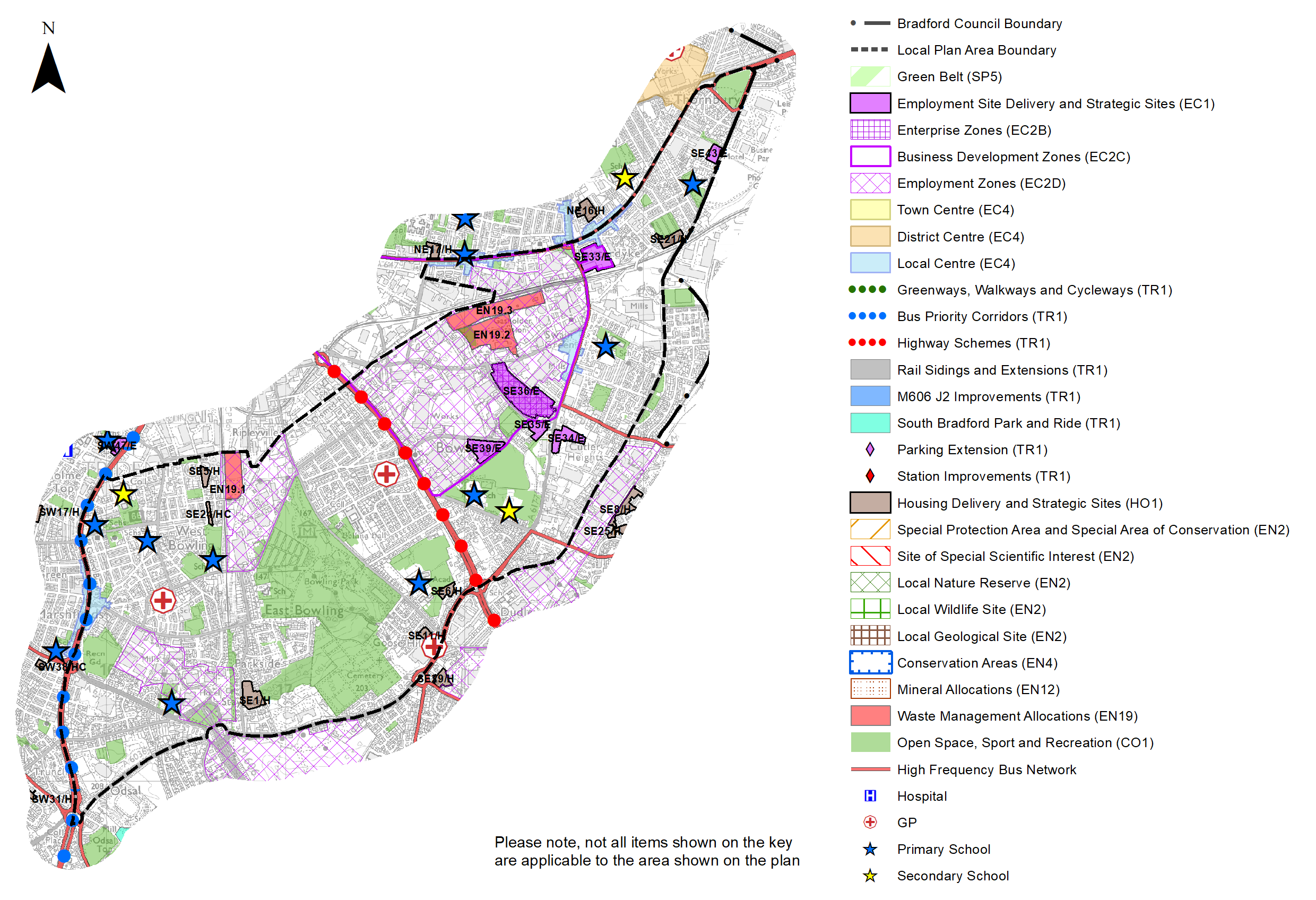
Figure 1: Location Plan
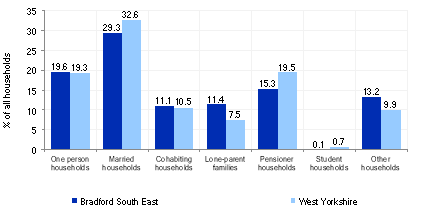
5.3.3 The area is a generally densely developed and populated urban environment which has a total resident population of 61,241. It also features two enterprise zones (Parry Lane and Staithgate Lane) and a significant proportion of the Bowling Back Lane Business Development Zone, which provide an indication of its diverse industrial / commercial make-up. Further characteristics of Bradford South East include:
- a slightly higher percentage of residents (26.5%) who are aged 0-15 compared to 23.7% and 20.6% of the District and regional averages respectively, whilst it has a below average population of those over 65 (12.2%);
- the working age population is slightly lower at 61.2% than the West Yorkshire average (62.8%);
- a significantly higher than sub-regional average proportion of the population who identify themselves as Non-White (29.5%) and Asian (20.8%) compared to the West Yorkshire averages of 18.2% and 13.1% respectively, and
- household composition indicates a higher proportion of lone parent families with dependent children at 30.7% than the sub-regional average (25.1%) and lower levels of pensioner households and married households.
Figure 2 below provides further information on household composition.
Figure 2: Household Composition – Bradford South East
|
Source: Census 2011 |
Planning for Prosperity
5.3.4 The Local Plan settlement hierarchy under Policy SP3 identifies the Regional City as the key focus for housing, employment, shopping, leisure, education, health and cultural activities and facilities. Growth in the South East quadrant will transform the economic, environmental, physical and social conditions of local communities and support the long term regeneration of both the regional city and wider District.
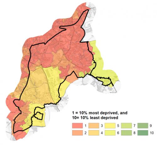
5.3.5 Bradford South East is characterised by fairly extensive levels of multiple deprivation, with over 40,000 people living in neighbourhoods ranked within the most deprived 10% of neighbourhoods in England. Figure 3 provides a fairly stark set of data which sets out the number of people in Bradford South East living in neighbourhoods ranked within the most deprived 20% of neighbourhoods in England, by overall IMD and individual domains. It can be noted that percentage rates are roughly double the deprivation percentages for West Yorkshire overall.
Figure 3: Deprivation – Bradford South East
|
Number of people in Bradford South East living in the most deprived 20% of areas of England by Indices of Deprivation (ID) 2019 domain |
||||||
|
Index of Multiple Deprivation |
Income domain |
Employment domain |
Education domain |
|||
|
48,485 |
40,132 |
39,738 |
47,131 |
|||
|
79.2% (West Yorkshire average = 36.2%) |
65.5% (West Yorkshire average = 31.9%) |
64.9% (West Yorkshire average = 32.4%) |
77.0% (West Yorkshire average = 35.3%) |
|||
|
Health domain |
Barriers to Housing and Services domain |
Living Environment domain |
Crime domain |
|||
|
41,331 |
0 |
31,685 |
53,792 |
|||
|
67.5% (West Yorkshire average = 33.8%) |
(West Yorkshire average = 1.8%) |
51.7% (West Yorkshire average = 39.8%) |
87.8% (West Yorkshire average = 48.2%) |
|||
|
Source: Ministry of Housing, Communities and Local Government (Indices of Deprivation 2019) |
||||||
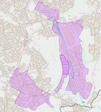
Figure 4 below provides a visual overview of deprivation by geographical areas.
Figure 4: Index of Multiple Deprivation South East
Economy and Employment
5.3.6 Economic activity rates at 65.1% are slightly below the West Yorkshire average of 68.5% and national average (England) of 68.9%. Statistics indicate that the average annual household income is £32,626 – significantly lower than the West Yorkshire average at £38,499. Unemployment claimant levels, youth unemployment levels and older employed are all above West Yorkshire averages.
5.3.7 The three largest industry groups for workforce jobs based in Bradford South East are Manufacturing (27.1%), Transport (12%) and Wholesale 9.6% (Business Register and Employment Survey (BRES). The main industry sectors that people living in Bradford South East work within are retail (4,384 employees, manufacturing 3,066 employees and health and social work (2,661 employees).
5.3.8 The main employment areas within Bradford South East are included on Figure 5 below and include:
- Bowling Back Lane
- Hall Lane
- Cutler Heights
- Law Street / Dudley Hill
- Tong Street / Shetcliffe Lane
- Westgate Hill Street
- Staygate
- Euroway Estate
- Low Moor
Figure 5: Bradford South East Employment Areas
Bowling Back Lane
Hall Lane
Staygate, Euroway and Low Moor
Cutler Heights, Law Street and Tong Street
Westgate Hill Street
5.3.9 Policy SP6 sets a District target for the provision of at least 72ha of open market employment land - use classes B2, B8 and E (formerly B1 type uses), with a significant proportion of this growth within Bradford South East. Bradford aims to be the UK fastest growing economy and Bradford South priority sectors continue to include a focus upon manufacturing, distribution and specialist construction. To continue to support economic growth within Bradford South a concentration of preferred employment land allocations, are identified within accessible locations and either close to existing employment areas, or within established estates or employment / business zones.
The strategy includes:
- Clustering of employment site options within, adjacent and nearby to Bowling Back Lane Business Development Zone / Parry Lane Enterprise Zone.
- Continued support for employment site allocations within the Euroway and Staithgate Lane Enterprise Zone
- Further employment growth along Tong Street / Westgate Hill Street, including a major new gateway employment site as part of the Tong Street urban extension.
- Continued protection of employment land to the east of Nufarm to allow for business expansion.
Table A provides details of the preferred employment allocations within Bradford South East. These sites are also identified on the Policies Map and within the site pro formas.
Retail
5.3.10 The Local Plan identifies the following important district and local centres within the Bradford South East area[1]:
District Centres:
- Tong Street
- Mayo Avenue
Local Centres:
- Holme Wood (Holme Wood)
- Laisterdyke1 (Bowling / Barkerend)
- Leeds Road (Bowling)
- Low Moor1 (Royds and Wibsey / Low Moor and Wyke)
- Marshfields / Manchester Road1 (Great Horton and Little Horton / Bowling)
- Sticker Lane (Bowling)
- Wyke (Low Moor and Wyke)
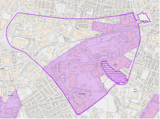
The extent of the District centre and Local Centre boundaries are shown on the Policies Map. Figures 6a-6d below provide an overview of the centres.
Figure 6a: Laisterdyke, Leeds Road and Sticker Lane Local Centres
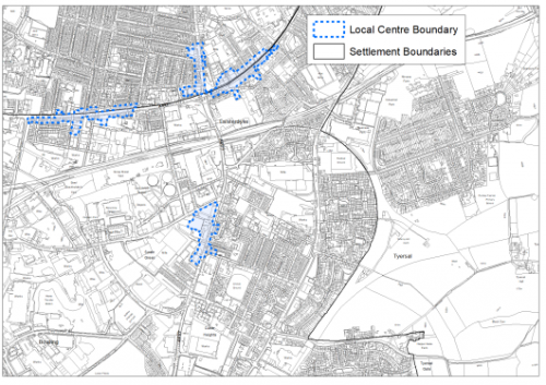
Figure 6b: Tong District Centre and Holmewood Local Centre
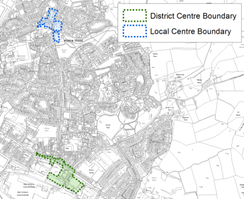
Figure 6c: Marshfields/Manchester Road Local Centre
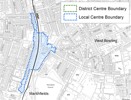
Figure 6d: Low Moor and Wyke Local Centres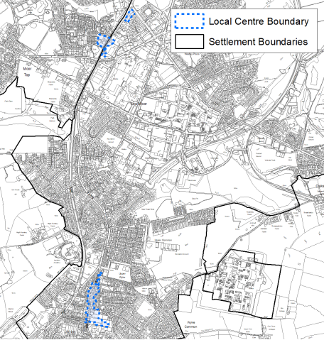
5.3.11 All retail centres have been subject to a review as part of the Retail and Leisure Study (2019). Some of the key conclusions and challenges are detailed below:
- Tong Street District Centre: the centre is effectively split into two separate and distinct areas on both sides of Tong Street, with a mix of unit sizes and operators. There is a potential need to improve pedestrian connectivity between Tong Street and the Avenue Retail Park and also explore measures to improve pedestrian crossing along Tong Street.
- Holme Wood Local Centre: considered a weak centre with significant issues in relation to vacancy rates and need for environmental improvements to the precinct.
- Laisterdyke Local Centre: generally good service provision and one of the largest local centres.
- Leeds Road Local Centre: broadly an attractive and healthy centre with a need to monitor vacancy rates.
- Low Moor Local Centre: small centre dominated by leisure uses with some support from convenience retail – would benefit from diversification of uses and environmental improvements.
- Marshfields Local Centre: Reasonable local centre catering for local needs – lacking in diversity and range and in places some uses are disconnected from the main local centre with a need to monitor vacancy levels.
- Sticker Lane Local Centre: In need of environmental improvements and improved maintenance.
- Wyke Local Centre: lack of financial and business services with relatively high vacancy rates and poor environmental quality in part.
Transport and Access
5.3.12 Lying at the southern end of the Bradford District, South East Bradford benefits from a range of excellent travel opportunities within the wider area which provide good links beyond the Bradford District. Transport connections to the east, Pudsey and west Leeds are also strong. The Leeds Old Road connects to the east to the Stanningley Ring Road and Wakefield Road is a strong connecting road corridor to Tong Street and out to Westgate Hill and beyond.
5.3.13 The M606 south to M62 Junction 26 is a key transport corridor from and to Bradford South East. The corridor is a key distribution route for businesses accessing the road network from the Euroway Trading Estate.
5.3.14 Bradford South East features the Low Moor Railway Station which is a key public 'park and ride' transport hub. The station lies on the Calder Valley line between Bradford and Halifax and currently provides an hourly service between the rail stations with connectivity further afield to the cities of Leeds, Manchester and Liverpool. There are also four direct Grand Central services to London King's Cross each day from this station.
5.3.15 The South East area of Bradford is well served by several frequent bus routes with services operated by First Bradford linking to Bradford City Centre to:
- 608 – local connections to Laisterdyke, Sticker Lane and Holme Wood
- 508 – connecting from Bradford Moor to Sticker Lane and through to Osdal Top.
- 620/621 – Wakefield Road to Bierley and Euroway
- 363/686/687/688/X63 – serving Manchester Road and Huddersfield Road to Wyke
5.3.16 Within Bradford South East 39% of all households have no car compared with 29% across West Yorkshire. The value of public transport and good walkable local services is therefore of great importance.
5.3.17 In terms of air quality, the M606 corridor, A6177 and Tong Street road corridors have been identified with NO2 levels in excess of 30ppm. The Bowling and Low Moor / Wyke areas lie within the proposed Clean Air Zone (CAZ). The Tong Street / Wakefield Road junction is an identified air quality area of concern.
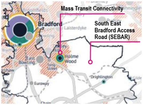
5.3.18 Strategic transport infrastructure projects to be delivered within the plan period and protected routes are set out on the Policies Map with the local plan. Key initiatives within Bradford South East are detailed in Table 1 and figure 7 below. Mass Transit infrastructure is discussed within the transport policy section of the plan and is likely to include infrastructure connections / corridors within Bradford South East (east / west connections to Leeds and South connections to Dewsbury to Bradford), although these are currently only at initial concept stage.
Table 1: Bradford South East Transport Projects
|
Policies Map Ref. |
Project Name |
Local Area |
|
TR1.E.1 |
Tong Street Highways Improvements |
Holme Wood |
|
TR1.E.1 |
Wakefield Road Improvement |
Bowling |
|
TR1.C.2 |
Manchester Road TCF |
Bowling |
|
TR1.E.1 |
M606 Junction 2 Improvement |
Low Moor and Wyke |
|
TR1.E.3 |
South Bradford Park and Ride |
Low Moor and Wyke |
|
TR1.B.2 |
Low Moor Station parking extension |
Low Moor and Wyke |
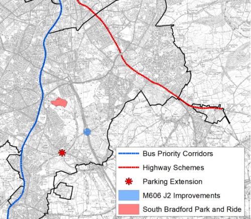 Figure 7: Proposed Bradford South East transport improvements
5.3.19 Ofcom digital connectivity data indicates that, average broadband download speeds in Bradford South East is just over 50 megabytes per second – above the West Yorkshire average, whilst there are 90 premises where speeds are below the Universal Service Obligation (USO)[2].
Planning for Homes
5.3.20 Bradford South East has 23,322 dwellings, of which 54.8% are owner occupied which is significantly lower than the West Yorkshire average of 63.4% The largest proportions of the area's housing stock consists of semi-detached (40.6%) and terraced housing (36.1%), which are above the sub-regional and national averages. Further information on dwelling types are detailed below in Figure 8. Almost one quarter of the stock was built before 1900 (22.8%) and almost 50% from 1945 to 1999 (47.3%) – both above sub- regional and national (England) averages.
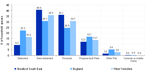
Figure 8: Dwelling Type Breakdown
5.3.21 Average house prices across all house types is lower than the West Yorkshire average with £105,983 being the average house price in the area which is over £77,000 less than the regional average of £183,194. The total affordability ratio between house prices and annual earnings which is usually used as a proxy for number of years' worth of earnings required for a house deposit is 2.49 years compared to a West Yorkshire average of 2.96, meaning that the area is theoretically more accessible for first time buyers.
5.3.22 Delivering new housing is a key part of the overall development strategy for the District. The Local Plan seeks to support the creation of sustainable communities in Bradford South East through the regeneration of existing urban areas, particularly supporting the economic, environmental, physical and social transformation of key areas including: Holme Wood, the re-cycling of brownfield land and the expansion of the urban area in sustainable locations. It will ensure that the housing needs and aspirations of local people can be met, together with those of future residents, including market and affordable housing. In addition, it will support the economic and regeneration aspirations for the wider area, as well as reflecting its role as the Regional City.
5.3.23 Policy SP8 sets out a requirement of 2,200 dwellings that will be delivered within Bradford South East within the plan period. These will be delivered through a mix of committed sites (those under construction or have planning permission but have not yet commenced) and allocations. New allocations comprise a mix of sites, including existing capacity within the urban area together with some contribution from the Green Belt in sustainable locations – primarily in relation to land to the East of Holme Wood (identified in the Core Strategy and Core Strategy Partial Review as an urban extension). Table 2 below sets out the housing position for Bradford South East, which also includes the application of non-implementation or discount rates for planning permissions and allocations. The Council will be supportive of additional proposals for new homes on additional small sites, particularly those that provide a redevelopment opportunity to bring forward land which has been previously used. Support will also be provided to developers who wish to redevelop larger sites and/or buildings for new homes not currently identified, subject to all relevant policies in the Local Plan
Table 2: Bradford South East - Summary of Housing Requirement and Supply
|
Housing Target |
2,200 units |
|
Carried Forward Commitments |
92 |
|
Commitment Discounted by 10% |
83 |
|
Remaining Allocation Requirement |
2,117 |
|
Identified Allocations |
2,362 |
|
Allocations Discounted by 10% |
2,126 |
|
Total Supply Contribution from Allocations |
2,126 |
5.3.24 Once the commitments are discounted and removed from the supply this leaves a residual allocation requirement of 2,117 units. The evaluated total supply of housing units from preferred allocation sites equates to 2,362 which in turn is discounted by 10% for non-implementation leaving a final allocation contribution of 2,126 across all sites to meet the remaining requirement.
5.3.25 Bradford South East's allocation mix of 35 sites includes, nine sites which are brownfield or mixed (split brownfield / greenfield) and the remainder greenfield. Of the greenfield sites seven sites are currently classified as Green Belt. The Green Belt sites refer to land off Ned Lane and north of Tong Street/Westgate Hill Street, which contribute in total 1,447 units (pre-any discounting) to meeting the overall requirement in Bradford South East. In delivering the target for new homes in Bradford South East it has been necessary to make some changes to the adopted green belt. Policy SP5 sets out The Councils approach and justification for green belt releases to accommodate new development and lists the sites proposed for allocation which current lie within or partly within the green belt
5.3.26 The new Local Plan preferred site allocations for residential development have the potential to support a wide range of housing types to meet the Bradford South East housing requirement and are set out in Table B. These sites are also identified on the Policies Map, detailed on the Site Pro Formas and on the local strategies map for each plan area. The strategy map and narrative for Holme Wood provides further detail on growth strategy for the urban extension areas. Further work will be required on detailed site master-planning to support growth within this area and align with any work on the development of the South East Bradford Access Road.
5.3.27 Development of site allocations should be in accordance with specified development guidelines and approximate site provision figures and all other relevant policies of this Local Plan.
Planning for Places and Communities
Green Belt, Natural Landscape and Historic Character
5.3.28 Bradford South East is characterised by a complex urban landscape which includes large areas of industrial land interconnected with urban neighbourhoods and defined post WWII housing estates on the south east and southern edges. Enclosed pasture land frame both the south and south eastern built form (Wyke, Bierley and Holme Wood) with various degrees of sensitivity in terms of landscape character type. Green Belt parcels of significant scale and openness cover within the Bierley and Holme Wood edge areas in particular.
5.3.29 The Bradford South East built up area does not feature any conservation areas, although Tong Village east of Holme Wood outside of the Bradford Urban Area is a designated conservation area. Within the Bradford South East built up area, there are a total of 218 listed buildings of which one is Grade I and six Grade II*. Within the Holme Wood extension study area there are a number of listed buildings including the Grade II* Ryecroft Hall. The designated historic battlefield of Adwalton Moor also forms part of the study area.
Green Infrastructure, Ecology, Open Space and Flood Risk
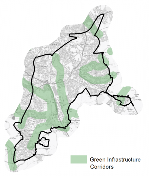
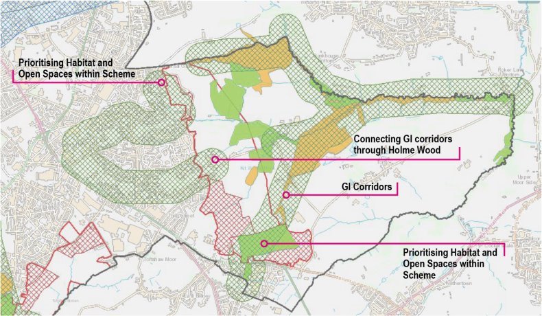
5.3.30 The area has a range of corridors and spaces that contribute towards its Green and Blue Infrastructure networks. There are particular strong Green Infrastructure (GI) corridors with watercourses adjacent to the M606 motorway corridor, through the Holme Wood estate and in Tong valley. There are significant opportunities to enhance the GI network and connect through into the city centre and through such areas as Bowling and Laisterdyke. Further GI information is detailed on Figure 9 below.
Figure 9: Green Infrastructure Corridors
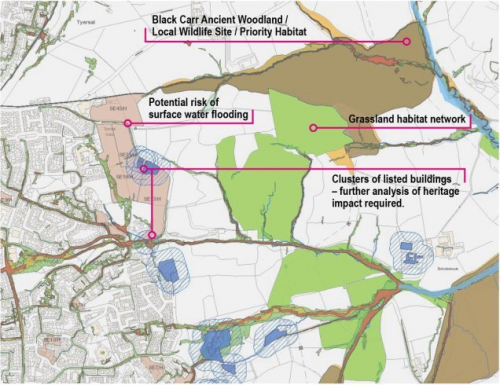
5.3.31 There are number of biodiversity designations within or close proximity to the Bradford South East settlement boundary, these include Tong Moor Local Nature Reserve / Local Wildlife Site, Westgate Hill, Railway Terrace / Raw Nook Local Nature Reserve and Toad Holes Beck Local Wildlife Site and Bierley Wood Local Wildlife Site. In addition, there are also a range of additional ecological assets, such as ancient woodland at Odsal Wood and Kit Wood, Park /Shackleton Woods and Black Carr east of Holme Wood.
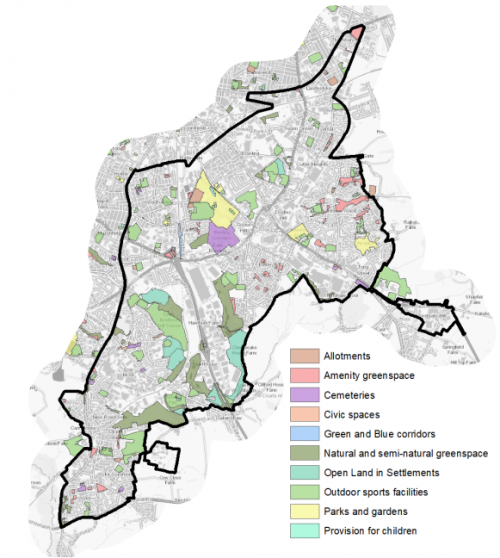
5.3.32 There are 222 sites identified as open space within Bradford South East covering an area of around 370.73ha – which is by far the largest quantity of open space within any of the settlement areas. While this is positive, there is an imbalance between the different types of open space that currently exist in the settlement area.
5.3.33 In terms of the distribution of spaces across the settlement area the map shows that there is a reasonable spread of sites throughout the area. However, the variety of spaces differs fairly substantially. The Bowling locality has a reasonably good range of different types of space with the large municipal Bowling Park and Bowling Cemetery providing a focal point of open space in this area. The Holme Wood area also sees a relatively good range of sites with two parks and a number of Amenity Greenspaces. The distribution and range of sites in the Bierley area however is less equitable, with a notable lack of sites in the industrial areas along Tong Street and the M606. Within the Wyke and Low Moor locality there is a notable concentration of Outdoor Sports sites, Natural and Semi-natural Greenspace and Open Land in Settlements space. There is no designated park space in this area and again a notable absence of space around the industrial areas at New Works Road.
5.3.34 Key sites within the Bradford South East settlement area include: Bowling Park, Bowling Cemetery, Knowles Park, Pit Hill Park, Victoria Park (Playing Field), Low Moor Banks Nature Reserve and South Bradford Golf Course.
5.3.35 Figure 10 below provides an illustrative overview of the area's open spaces and based on the findings from the typology analysis. It shows that for six of the typologies (Amenity Greenspace, Cemeteries, Natural and Semi-natural Greenspace, Open Land in Settlements, Outdoor Sports and Provision for Children) there are positive deviations from the standard provision requirements which indicates that there are good levels of provision of these types of spaces in this area. However, for parks and gardens, green and blue corridors and allotments space, these have negative deviations and these should be a high priority for additional provision.
Figure 10: Bradford South East - Open Space Overview
5.3.36 Within Low Moor and Wyke, land towards the north of Low Moor Banks has been identified as Flood Zone 2 and 3, as is land on the fringe of South Bierley associated with a watercourse. A wide range of locations within the built up area have been identified as of risk of surface water flooding.
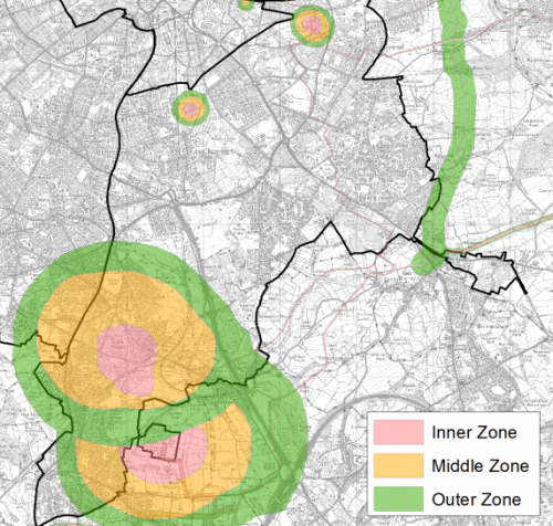
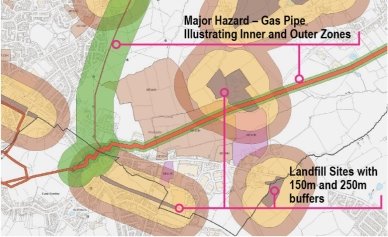
5.3.37 Development proposals in this part of South East Bradford are also constrained by the proximity to inner, middle and outer zones of a designated major hazard sites. These include:
- Kemira Chemicals, East Bowling
- Birkshall Gas Holder, Peace Street, Bowling / Laisterdyke
- Nufarm, Wyke Lane (two sites)
5.3.38 Any proposed developments within these zones will be subject to further detailed considered and agreement with the Health and Safety Executive. Figure 10 below provides an overview of major hazard sites.
Figure 11: Bradford South East – Major Hazard Sites
Community Infrastructure – Education, Health and Utilities
5.3.39 Bradford South East has a wide range of community facilities to meet the day to day needs of its local residents. These facilities range from schools, health and GP facilities through to post offices, places of worship, community halls/centres, playgrounds, libraries and various sporting facilities.
5.3.40 The area is served by 28 primary schools which have the capacity to accommodate 5,115 pupils. Most schools are under capacity, with only four being over capacity. There are 5 secondary schools (Dixons Kings Academy, Dixons Macmillan Academy, Dixons Trinity Academy, Co-Op Academy Grange and Buttershaw Business and Enterprise College Academy.
5.3.41 Pupils attainment levels at Key Stages 1,2 and 4 (GCSE) is below the West Yorkshire and national (England) average scores. For Key Stage 4 (2013-14 results) this is 315.1 average point score compared to 321.9 compare to 353.5 (West Yorkshire) and 366.3 (England).
5.3.42 Bradford South East has 7 GP Surgeries / health centres within the area, with a higher prevalence of depression and obesity reported through the GP practices than the West Yorkshire averages. Secondary, non-emergency healthcare is provided within the Bradford South West area at St Luke's Hospital in Little Horton, around 1km to the south west of Bradford City Centre.
5.3.43 Average life expectancy at birth for Bradford South East residents is 76 for men and 80 for women, which is lower than sub-regional and national (England) figures. Healthy life expectancy is very significantly lower at 56 for males and 57 for females than both sub- regional (61.3 and 62.6 respectively) and national (England) figures (63 and 65 respectively). Figure 12 below shows the location of local schools and medical facilities.
5.3.44 When planning for the long-term development of Bradford South East, it is vital that new development is supported by the appropriate infrastructure. The capacity, quality and accessibility of services and facilities are all key components in ensuring people can enjoy providers and others including the Local Education Authority, Clinical Commissioning Group and utilities providers to determine the impacts of future growth and development on local infrastructure capacity and provision. Further infrastructure details will be published through the Local Infrastructure Plan and as part of the Regulation 19 stage of the local plan.
Figure 12: Schools & Medical Facilities in Bradford South East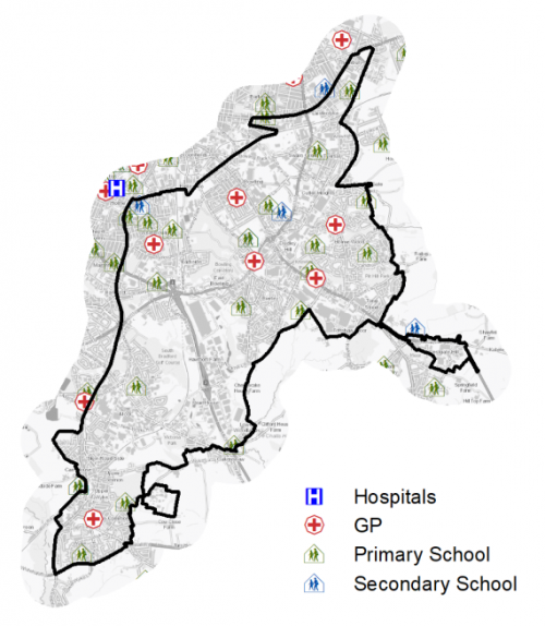
Local Area Strategies and Plans
Bradford South East Local Areas
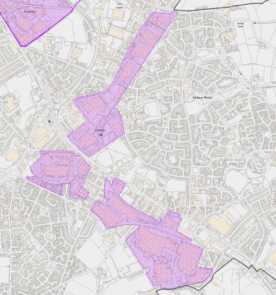
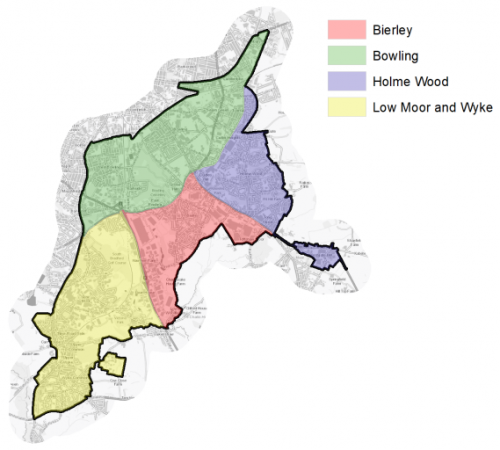
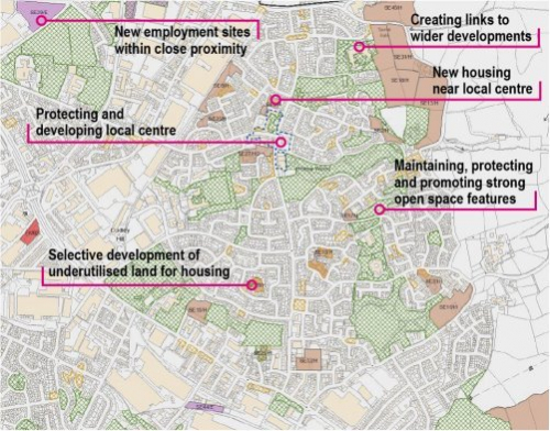
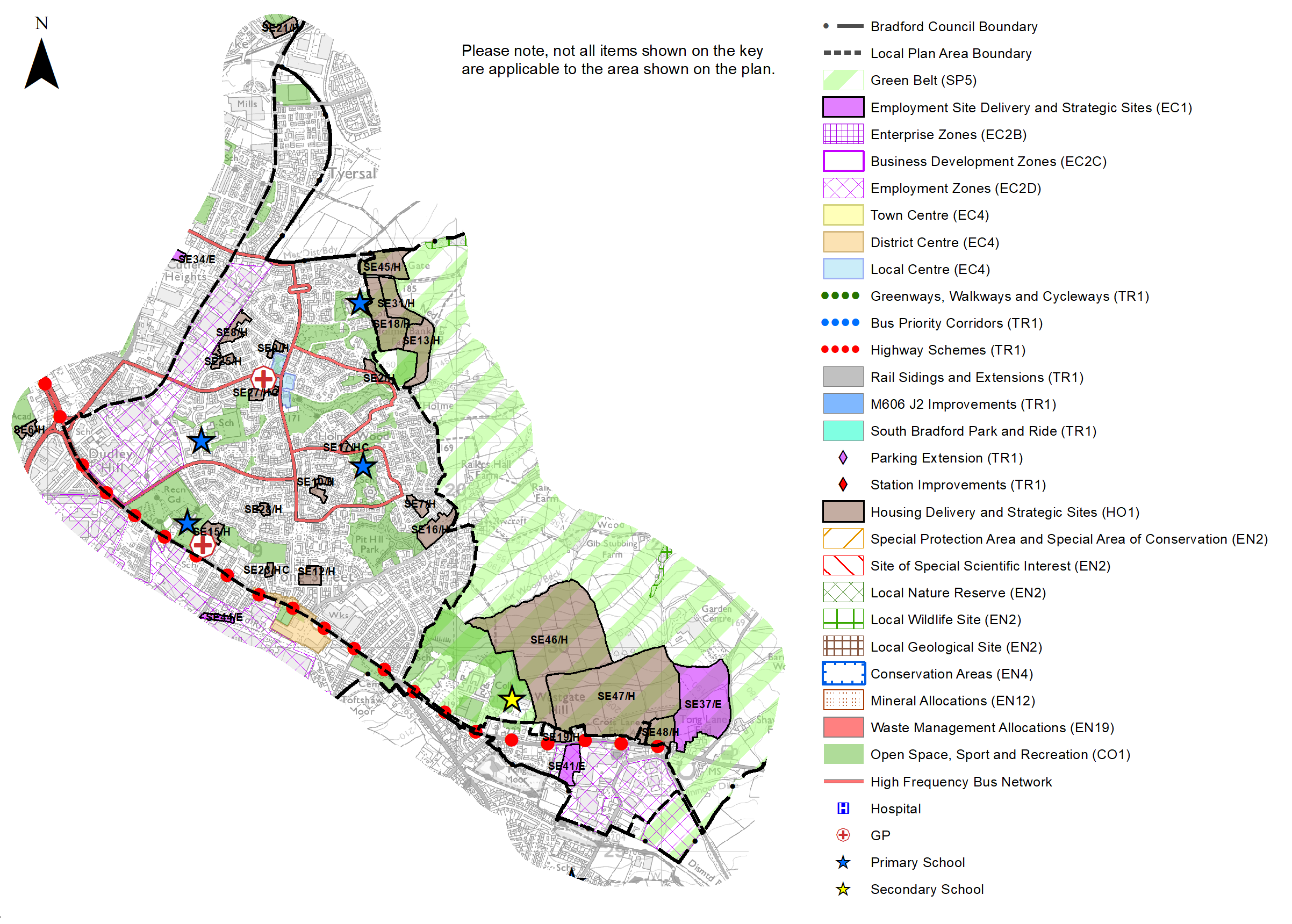
5.3.45 The Bradford South East sub-area has been broken down into 4 defined local areas with supporting spatial strategies; these are referred to as: Bowling; Low Moor and Wyke; Bierley and Holme Wood. These local areas are set out in Figure 13 below. Each spatial strategy provides an overview of the local area and sets out the preferred allocations for housing and employment sites.
Figure 13: Bradford South East Local Plan Areas
|
Local Area Strategy and Plan - Bierley |
|
|
The key elements of the local area strategy for Bierley include:
Integrating safe active travel routes (cycling and walking) through neighbourhoods, to services and facilities and connected to new employment sites and reduce the impact of traffic and pollution on residentialcommunities Building better active connectivity and greenways across the South East linking Low Moor/Wyke to the west and Holme Wood to the north and beyond |
|
Local Area Strategy and Plan- Bowling |
|
The key elements of the local area strategy for Bowling include:
|
|
Local Area Strategy and Plan - Low Moor and Wyke |
||
|
The key elements of the local area strategy for Low Moor and Wyke include:
|
||

|
Local Area Strategy and Plan - Holme Wood |
|
Holme Wood has been identified as an area for wide ranging economic, social, community and housing renewal for many years and is a key component of the regeneration strategy for Bradford South East. The strategy focus within the Local Plan continues the aspirations of the Holme Wood and Tong Neighbourhood Development Plan to concentrate upon both the renewal of the existing estate and the sensitive expansion of development to meet housing and employment needs. The key components of the local area strategy are set out below:
Integrating new housing and supporting facilities New housing will be supported by services and facilities - a protected local centre with environmental improvements and enhancement and more clearly defined open spaces linked to a wider green infrastructure strategy. The local area strategy includes the allocation of 13 housing sites within Holme Wood with a total yield of approximately 279 units. The sites range from small or micro sites with a yield of 5 units through to small / medium size sites with a yield of 30-40 units. Housing viability is challenging within Holme Wood and there will be a need to take a packaged approach to promoting sites with potentially linked environmental improvements. This approach will be further explored through master-planning and implementation work. The defined local centre remains a key feature of Holme Wood but there is a need to tackle commercial vacancy levels and environmental improvements to support use and overall viability. Community uses will continue to be supported within the local centre. Investing in quality open spaces and green infrastructure
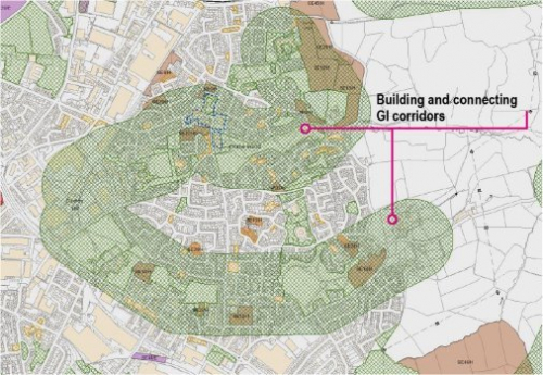
Holme Wood has a large number of open spaces but many are of a similar character/type and there are opportunities to diversify the range of open spaces across the area and help promote a clearer sense of place and environmental quality. The Green Infrastructure (GI) within Holme Wood should also be seen as part of a much wider network of spaces and there are opportunities to create stronger linkages to other urban areas (north and south in particular) but also east of the built up area. There is little in the way of woodland within the built up area and there are significant opportunities to contribute to Bradford's urban forestry and the wider woodland network across the District.
Key Green Infrastructure Corridors
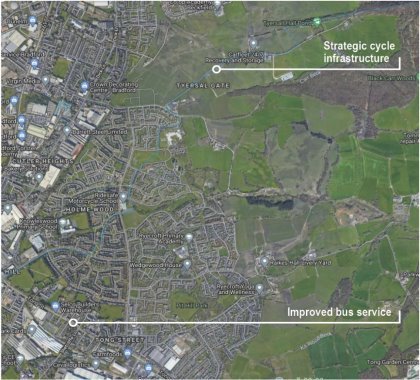
Location of key areas of Open Space and key amenities in Holme Wood Improving accessibility Development of strategic greenways and cycle-ways that better integrate the Holme Wood area to the eastern conurbations of Leeds and ensure that the area is well connected to key employment areas including much of South Bradford will include implementing a series of highways and transport improvements including Tong Street and subject to ongoing feasibility and option analysis, the potential development of the South East Bradford Access Road. The area will be prioritised as part of the emerging Mass Transit network.
The built form will need to be informed by detailed master-planning and further analysis of constraints and opportunities, but the main focus will be upon ensuring built and natural environment considerations are central to any scheme design and that various development hazards are effectively addressed in finalising scheme layout. There are clear opportunities to raise the bar in housing and employment design and quality in this strategically well located area of south Bradford and strengthen the Tong Street as a gateway into the urban area. The scale of development is broadly on par with the ambitions set out in the adopted core strategy and previous vision work on the regeneration of Holme Wood.
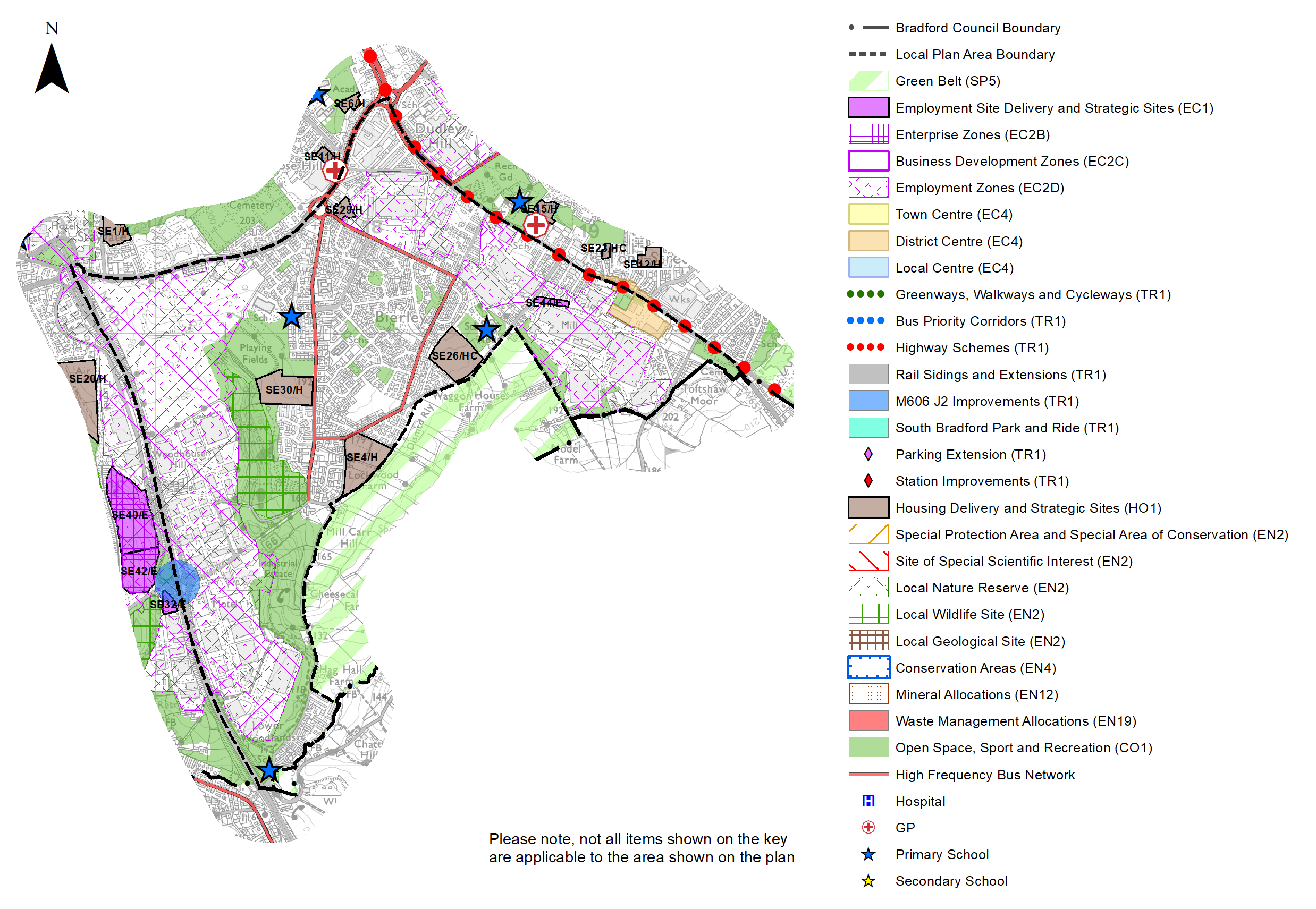
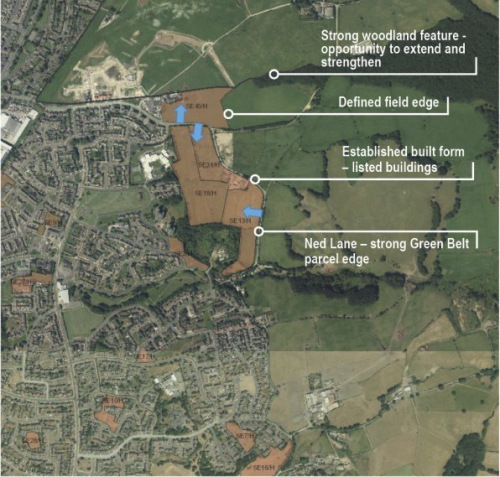
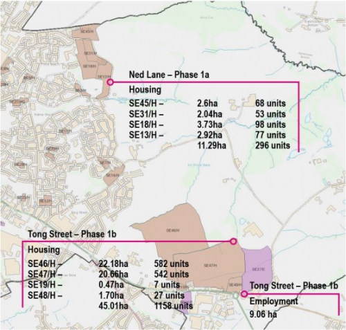
Within the Ned Lane area sites SE13/H, SE18/H, SE31/H, and SE45/H are expected to come forward as part of a detailed masterplan focused upon maintaining a strong Green Belt edge to the settlement.
Holme Wood South Within the Tong Street/Westgate Hill Street areas, sites SE19/H, SE46/H, SE47/H, SE48/H and SE37/E are expected to come forward as part of a comprehensive and detailed masterplan covering as a minimum:
The Masterplan may form part of a wider corridor development strategy for the South East Bradford Access Road, subject to ongoing technical studies and evidence. The new employment site (SE37/E) has been identified which is linked to new investment in housing and infrastructure. The focus for this area will be on high quality design and jobs for local people. The development of this site should provide a gateway to the overall development
Development expectations for Holme Wood North and South |
|
|
 Identification of sensitive housing extensions
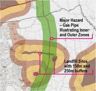 Taking a sensitive approach to growth through the allocation of a series of 'village scale' urban extensions to the built form in the Green Belt, to include housing growth (phase 1a) off Ned Lane for circa 296 units and land off Tong Street (phase 1b) for housing growth in the range of 1,158 units and employment land of just over ten hectares.
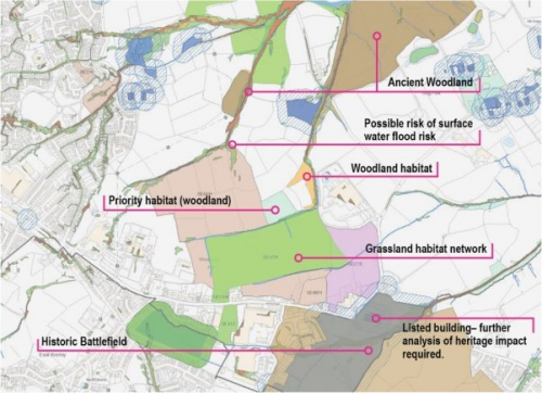
 Holme Wood North
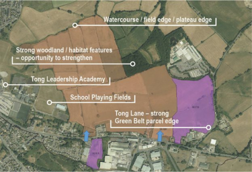
(2) Consultation Question 80
Local Area Strategy and Plan - Bowling
Q. Please provide any comments you may have on the area strategy?
If you have an alternative to the approaches undertaken, please provide further details and evidence in support.
(6) Consultation Question 81
Local Area Strategy and Plan - Low Moor and Wyke
Q. Please provide any comments you may have on the area strategy?
If you have an alternative to the approaches undertaken, please provide further details and evidence in support.
(7) Consultation Question 82
Local Area Strategy and Plan - Bierley
Q. Please provide any comments you may have on the area strategy?
If you have an alternative to the approaches undertaken, please provide further details and evidence in support.
(1563) Consultation Question 83
Local Area Strategy and Plan - Holme Wood
Q. Please provide any comments you may have on the area strategy?
If you have an alternative to the approaches undertaken, please provide further details and evidence in support.
Preferred Site Allocations and Site Pro Formas
5.3.46 The preferred site allocations for Bradford South East for both employment and housing are detailed below in Tables A and B. These tables are subsequently followed by site pro formas for each site providing a summary of key site information and characteristics.
Table A: Bradford South East Employment Sites - Preferred Allocations
|
Site Ref |
Site Name |
Type |
Site Area (Gross Hectares) |
Local Area |
|
SE32/E |
Euroway Trading Estate, Commondale Way |
Greenfield |
0.51 |
Low Moor & Wyke |
|
SE33/E |
Land East of Laisterdyke and South Leeds Road |
Brownfield |
1.99 |
Bowling |
|
SE34/E |
Land East of Sticker Lane |
Greenfield |
1.35 |
Bowling |
|
SE35/E |
Lower Lane, Parry Lane and Sticker Lane |
Mixed (Brownfield and Greenfield) |
1.19 |
Bowling |
|
SE36/E |
Parry Lane |
Brownfield |
4.90 |
Bowling |
|
SE37/E |
North of Westgate Hill/ West of Tong Lane |
Greenfield and Green Belt |
9.06 |
Holme Wood |
|
SE38/E |
Nufarm, Wyke Lane |
Greenfield |
5.42 |
Low Moor & Wyke |
|
SE39/E |
Neville Road / Lower Lane |
Mixed (Brownfield/Greenfield) |
1.57 |
Bowling |
|
SE40/E |
Staithgate Lane North |
Greenfield |
5.82 |
Low Moor & Wyke |
|
SE41/E |
Westgate Hill Street |
Greenfield |
1.50 |
Holme Wood |
|
SE42/E |
Staithgate Lane South |
Greenfield |
2.87 |
Low Moor & Wyke |
|
SE43/E |
Dick Lane |
Greenfield |
0.55 |
Bowling |
|
SE44/E |
Shetcliffe Lane |
Brownfield |
0.42 |
Bierley |
|
Total |
37.15 |
Site SE38/E is not counted as contributing towards meeting general employment needs as it is linked to the expansion of an existing business.
Table B: Bradford South East Housing Sites - Preferred Allocations
|
Site Ref |
Site Name |
Dwellings |
Local Area |
|
SE1/H |
Highbridge Terrace, West Bowling |
30 |
Bowling |
|
SE2/H |
Copgrove Road, Holme Wood |
12 |
Holme Wood |
|
SE3/H |
Cleckheaton Road |
16 |
Loor Moor and Wyke |
|
SE4/H |
Spen View Lane / Shetcliffe Lane, Bierley |
100 |
Bierley |
|
SE5/H |
Upper Castle Street, West Bowling |
17 |
Bowling |
|
SE6/H |
Rooley Lane |
10 |
Bowling |
|
SE7/H |
Landscove Avenue, Holme Wood |
20 |
Holme Wood |
|
SE8/H |
Grayswood Drive, Holme Wood |
32 |
Holme Wood |
|
SE9/H |
Stoneyhurst Square, Holme Wood |
10 |
Holme Wood |
|
SE10/H |
Land at Muirhead Fold, Holme Wood |
19 |
Holme Wood |
|
SE11/H |
Bolling Hall Laundry - off Rooley Lane |
18 |
Bowling |
|
SE12/H |
Cordingley Street, Holme Wood |
36 |
Holme Wood |
|
SE13/H |
Ned Lane, Holme Wood (1) |
77 |
Holme Wood |
|
SE14/H |
Albert Terrace, Oakenshaw |
25 |
Low Moor and Wyke |
|
SE15/H |
Proctor Street Playing Fields, Off Tong Street, Holme Wood |
29 |
Holme Wood |
|
SE16/H |
Holme Lane, Holme Wood |
40 |
Holme Wood |
|
SE17/H |
Kesteven Road / Heysham Drive, Holme Wood |
11 |
Holme Wood |
|
SE18/H |
Ned Lane, Holme Wood (2) |
98 |
Holme Wood |
|
SE19/H |
Westgate Hill Street, Tong |
7 |
Holme Wood |
|
SE20/H |
Dean Beck Avenue |
145 |
Low Moor and Wyke |
|
SE21/H |
New Lane, Laisterdyke |
28 |
Bowling |
|
SE22/H |
Furnace Road, Oakenshaw |
14 |
Low Moor and Wyke |
|
SE23/H |
Tennis Avenue |
11 |
Holme Wood |
|
SE24/HC |
Upper Castle Street |
9 |
Bowling |
|
SE25/H |
Grayswood Drive, Holme Wood |
13 |
Holme Wood |
|
SE26/HC |
Shetcliffe Lane |
106 |
Bierley |
|
SE27/H |
Mead View, Holme Wood |
41 |
Holme Wood |
|
SE28/H |
Somerton Drive, Holme Wood |
5 |
Holme Wood |
|
SE29/H |
Kaycell Street, Bierley |
23 |
Bierley |
|
SE30/H |
Bierley Lane, Bierley |
88 |
Bierley |
|
SE31/H |
Land West of Ned Lane, Holme Wood |
53 |
Holme Wood |
|
SE45/H |
Holme Lane/Raikes Lane |
68 |
Holme Wood |
|
SE46/H |
Land West of Tong Lane and east of Holme Wood |
582 |
Holme Wood |
|
SE47/H |
Westgate Hill Street, Holme Wood |
542 |
Holme Wood |
|
SE48/H |
Westgate Hill Street, Tong |
27 |
Holme Wood |
|
Total |
2362 |
Note: The sites ending in "HC" had outline planning permission at 31st March 2020. Some sites are subject to current planning applications
(31) Consultation Question 84
Bradford South East - Site Allocations and Site Pro Formas
The Local Plan sets out a series of preferred site allocations. If you wish to make representations on any of the sites proposed, please provide site reference and feedback under this question.
If you wish to propose an additional or alternative site(s) to the preferred allocations listed, please also provide a plan with a red line and any further details in support.
[1] Laisterdyke also falls partly within Bradford North East, and Marshfields and Low Moor partly within Bradford South West)
[2] Universal Service Obligation (USO) - download speeds at or above 10Mbit/s and upload speeds at or above 1Mbit/s including non-matched records and zero predicted speeds
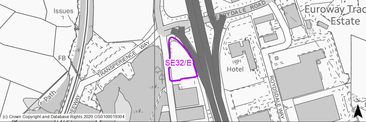
(5) SE32/E - Euroway Trading Estate, Commondale Way
Site location
Regional City - Bradford SE
Ward
Wyke
Site description
Greenfield site on the edge of established employment area.
Proposed Allocation
Employment
SHLAA referencce
N/A
Indicative no. dwellings
N/A
Site area (Gross) (ha)
0.51
Ownership
Public / Private
Delivery timescales
2025-30
Type (PDL/Greenfield)
Greenfield - 100%
Green Belt
No
Flood Zone
Flood Zone 1 - low risk of flooding.
Potential site access
Site can be accessed from Commondale Way but it will need regrading for development and access point will need to be away from main junction. A direct access from M606 slip road will be unacceptable. Highways England may need consulting as site boundary is with M606.
Public Transport Accessibility
Within 800m of Rail Station
Sustainability Appraisal
The site has been proposed for employment development, which would be likely to deliver a major boost to the range of local employment opportunities at this location whilst also providing a boost to the local economy. A major positive score has therefore been predicted for the employment and economy themed SA Objectives.
Minor positive effects were predicted for other socio-economic themed SA Objectives due to the additional benefits of a new employment site, such as the potential for increasing the local offering of services and amenities and opportunities to learn new skills.
There have been no significant adverse effects predicted, but minor adverse effects were predicted for a range of natural environment themed SA Objectives, largely due to the potential impacts of new development on a 100% greenfield site and nearby deciduous woodland priority habitat.
Habitats Regulations Assessment
This site is beyond the zones of influence of the South Pennine Moors SPA/SAC and is therefore unlikely to have any significant effects, a HRA is not required.
Green Belt
N/A – Site not within the Green Belt.
Constraints and Opportunities
• Within GI corridor.
• Within 150m of landfill - potential contamination issues.
• Southern section of the site includes small pocket of land of High Risk Mining Area.
• Site is within close proximity to potential major junction improvement (junction 2 M606).
• Former mining activities high risk development area to the southern section of the site which will require further investigation.
Development considerations
• Close proximity to M606 - prime industrial area for logistics and distribution space.
• Site capacity may be reduced due to proximity to potential junction improvements.
• Site access from Commondale Way will need to be regraded and away from the main junction.
• Further analysis required on site contamination and potential mining works.
• Opportunity to support GI through the site subject to design and layout.
Conclusion/Summary
Visible site within M606 corridor - good gateway opportunity site for high quality development - maximising GI integration opportunities. Development capacity may need to be re-evaluated in light of any junction improvement impacts.
Use Class
Class B2/B8
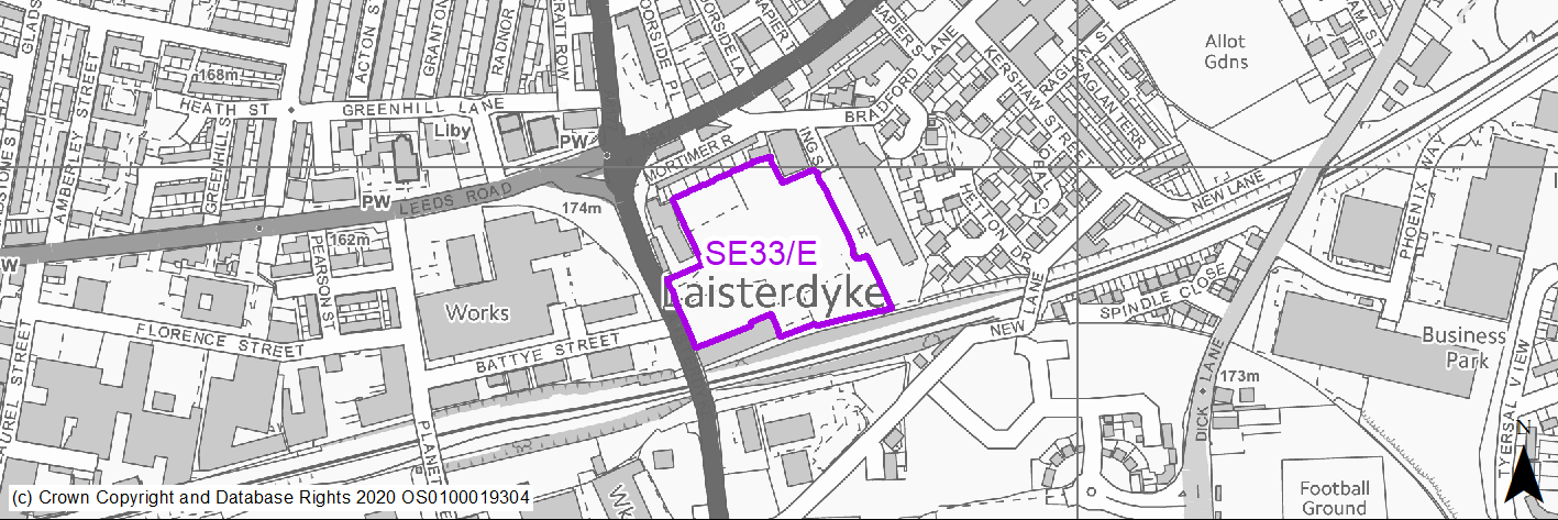
(3) SE33/E - Land to the East of Laisterdyke and South of Leeds Road
Site location
Regional City - Bradford SE
Ward
Bradford Moor
Site description
Mix of open storage and greened over vacant brownfield site.
Proposed Allocation
Employment
SHLAA referencce
SE/026 - multiple
Indicative no. dwellings
N/A
Site area (Gross) (ha)
1.99
Ownership
Private
Delivery timescales
2025-30
Type (PDL/Greenfield)
PDL - 100%
Green Belt
No
Flood Zone
Flood Zone 1 - low risk of flooding.
Potential site access
No apparent access issues. Access point from Laisterdyke.
Public Transport Accessibility
Bus Stop within 400m Frequent service
Sustainability Appraisal
The site has been proposed for employment development, which would be likely to deliver a major boost to the range of local employment opportunities at this location whilst also providing a boost to the local economy. A major positive score has therefore been predicted for the employment and economy themed SA Objectives.
A major adverse effect arises for the climate change resilience SA Objective due to approximately 15% of the site being at medium and high risk of surface water flooding, and it being unclear whether this land could be entirely avoided through a careful layout of the development.
A second significant adverse effect has been predicted for the air quality SA Objective as a result of the site being partially within the CAZ. Development here could potentially make achieving air quality improvement targets within the CAZ more difficult.
Minor positive effects were predicted for a range of socio-economic themed SA Objectives due to the additional benefits of a new employment site, such as the potential for increasing the local offering of services and amenities and opportunities to learn new skills.
Minor adverse effects were predicted for a range of natural environment themed SA Objectives, primarily as a result of the impacts of new development on a predominantly greenfield site. A row of Grade II Listing Buildings are adjacent to the northern perimeter of the site; development here would be likely to alter the setting of this sensitive heritage asset.
Habitats Regulations Assessment
This site is beyond the zones of influence of the South Pennine Moors SPA/SAC and is therefore unlikely to have any significant effects, a HRA is not required.
Green Belt
N/A – Site not within the Green Belt.
Constraints and Opportunities
• Site is located within a Business Development Zone.
• A significant row of heritage assets (Grade II) adjacent to the northern edge of the site.
• Risk of surface water flooding within the southern section of the site.
• Site is located within a GI opportunity corridor.
• Site is within 150m landfill buffer and has evidence of previous occupancy.
Development considerations
• Primary access from Bradford Lane.
• Strong buffer required to the north of the site in light of listed residential properties.
• Opportunity to integate GI features through the site including management of any onsite flooding.
Conclusion/Summary
BDZ located site with opportunity to provide new employment space and enhance the profile of the zone within this location together with GI enhancement and protection of listed properties.
Use Class
Class B2/B8
(2) SE34/E - Land East of Sticker Lane

Site location
Regional City - Bradford SE
Ward
Bowling and Barkerend
Site description
Vacant green field site.
Proposed Allocation
Employment
SHLAA referencce
SE/022
Indicative no. dwellings
N/A
Site area (Gross) (ha)
1.35
Ownership
Private
Delivery timescales
2030-35
Type (PDL/Greenfield)
Greenfield - 100%
Green Belt
No
Flood Zone
Flood Zone 1 - low risk of flooding.
Potential site access
No apparent access issues. Adjoins Sticker Lane via existing access.
Public Transport Accessibility
Bus Stop within 400m Frequent service
Sustainability Appraisal
The site has been proposed for employment development, which would be likely to deliver a major boost to the range of local employment opportunities at this location whilst also providing a boost to the local economy. A major positive score has therefore been predicted for the employment and economy themed SA Objectives.
A significant adverse effect has been predicted for the air quality SA Objective as a result of the site falling partially within the CAZ. Development here could potentially make achieving air quality improvement targets within the CAZ more difficult.
Minor positive effects were predicted for other socio-economic themed SA Objectives due to the additional benefits of a new employment site, such as the potential for increasing the local offering of services and amenities and opportunities to learn new skills.
The site is greenfield and contains various GI elements including trees. Minor adverse effects were predicted for a range of natural environment themed SA Objectives due to the potential impacts of new development on such a site.
Habitats Regulations Assessment
This site is beyond the zones of influence of the South Pennine Moors SPA/SAC and is therefore unlikely to have any significant effects, a HRA is not required.
Green Belt
N/A – Site not within the Green Belt.
Constraints and Opportunities
• Classified in part as amenity greenspace and to the rear as natural and semi-natural greenspace.
• Some limited potential for surface water flooding in parts of the site.
• GI coverage of site is fairly extensive and within GI corridor with hedgerow material across the eastern section.
• Site is surrounded by industrial, office and car sale uses and opposite a BZD.
• Site is within 150m of landfill site and pockets of High Risk Mining in the northern section of the site and extreme eastern edge.
Development considerations
• Access off Sticker Lane.
• Strong GI and open space strategy required to support development.
• Scheme will need to integrate with surrounding commercial land uses.
Conclusion/Summary
Accessible employment site within close proximity to BDZ with potential to integrate GI and open space features as part of detailed scheme design.
Use Class
Class B2/B8
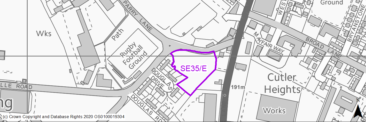
(2) SE35/E - Land adjoining Lower Lane, Parry Lane and Sticker Lane
Site location
Regional City - Bradford SE
Ward
Bowling and Barkerend
Site description
Mix of green field and outdoor storage.
Proposed Allocation
Employment
SHLAA referencce
SE/023 + SE/131 - multiple
Indicative no. dwellings
N/A
Site area (Gross) (ha)
1.19
Ownership
Public / Private
Delivery timescales
2025-30
Type (PDL/Greenfield)
PDL - 40% Greenfield - 60%
Green Belt
No
Flood Zone
Flood Zone 1 - low risk of flooding.
Potential site access
Established access off Parry Lane.
Public Transport Accessibility
Bus Stop within 400m Frequent service
Sustainability Appraisal
The site has been proposed for employment development, which would be likely to deliver a major boost to the range of local employment opportunities at this location whilst also providing a boost to the local economy. A major positive score has therefore been predicted for the employment and economy themed SA Objectives.
A significant adverse effect has been predicted for the air quality SA Objective due to the site being situated entirely within the CAZ. Development here could potentially make achieving air quality improvement targets within the CAZ more difficult.
Minor positive effects were predicted for other socio-economic themed SA Objectives due to the additional indirect benefits of a new employment site, such as the potential to increase the local offering of services and amenities and opportunities to learn new skills.
Minor adverse effects were predicted for a range of natural environment themed SA Objectives, primarily as a result of the impacts of new development on the greenfield aspects of the site
Habitats Regulations Assessment
This site is beyond the zones of influence of the South Pennine Moors SPA/SAC and is therefore unlikely to have any significant effects, a HRA is not required.
Green Belt
N/A – Site not within the Green Belt.
Constraints and Opportunities
• Site is on the edge of the BZD and Parry Lane Enterprise Zone.
• Residential to the west and south west.
• Land is within 150m of landfill and also contains former coal mining pits (high risk mining in the north west section of the site).
• Change is site levels is noticeable.
• Former mining activities high risk development area to the north west edge of the site which will require further investigation.
Development considerations
• Established access off Parry Lane.
• Need to retain environmental buffer to residential properties.
• Site development envelope may be restricted by previous uses or mining works and will need to be subject to detailed investigation.
• Bradford BDZ linked redevelopment opportunity.
Conclusion/Summary
Strategically well-positioned employment site option which help enhance the local area and provide small scale employment units, subject to further investigative works.
Use Class
Class B2/B8
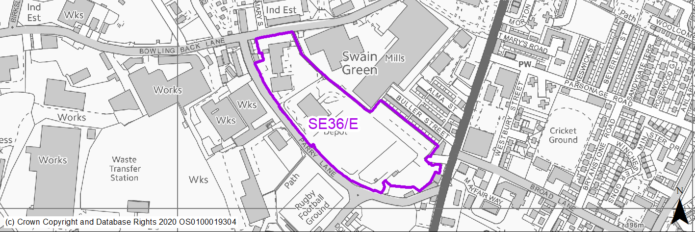
(4) SE36/E - Parry Lane
Site location
Regional City - Bradford SE
Ward
Bowling and Barkerend
Site description
Cleared brownfield site.
Proposed Allocation
Employment
SHLAA referencce
PES004
Indicative no. dwellings
N/A
Site area (Gross) (ha)
4.9
Ownership
Public / Private
Delivery timescales
2020-30
Type (PDL/Greenfield)
PDL - 100%
Green Belt
No
Flood Zone
Flood Zone 1 - low risk of flooding.
Potential site access
Adjoins Parry Lane. No apparent major access issues.
Public Transport Accessibility
Bus Stop within 400m Frequent service
Sustainability Appraisal
The site has been proposed for employment development, which would be likely to deliver a major boost to the range of local employment opportunities at this location whilst also providing a boost to the local economy. A major positive score has therefore been predicted for the employment and economy themed SA Objectives.
Major adverse effects have been predicted for the site’s impact on the water resources SA Objective due to Hallowfield Beck, which runs adjacent to the western perimeter and falls partially within the site boundary. Development here could pose a risk to the water quality.
Minor positive effects were predicted for other socio-economic themed SA Objectives due to the additional benefits of a new employment site, such as the potential for increasing the local offering of services and amenities and opportunities to learn new skills.
The site is 100% brownfield but contains trees and has an area of deciduous woodland priority habitat in the north-western portion of the site. Minor adverse effects were predicted for a range of natural environment themed SA Objectives as a result of the impacts of new development on such a site. There is a very limited extent of land at medium and high risk of surface water flooding, which is expected to be avoided through careful layout of the development. The northern perimeter of the site adjoins a Grade II Listed Building, the setting of which would likely be adversely altered by the development.
Habitats Regulations Assessment
This site is beyond the zones of influence of the South Pennine Moors SPA/SAC and is therefore unlikely to have any significant effects, a HRA is not required.
Green Belt
N/A – Site not within the Green Belt.
Constraints and Opportunities
• This site is designated as a Leeds City Region Phase 2 Enterprise Zone site - it is located in the Bradford Business Development Zone.
• Industrial land and premises on all sides.
• Within 150m buffer of landfill and pockets of High Risk Mining across the site.
• Northern edge of the site within gas pipeline buffer.
• Pockets of potential surface water pooling across site.
Development considerations
• New access required from Parry Lane.
• Site is subject to detailed work programme with redevelopment underway.
• Designated Enterprise Zone within a Business Development Zone.
Conclusion/Summary
Key enterprise zone site - works progressing on site delivery.
Use Class
Class B2/B8
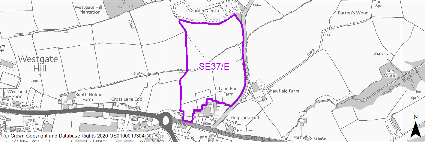
(1522) SE37/E - North of Westgate Hill and West of Tong Lane
Site location
Regional City - Bradford SE
Ward
Tong
Site description
Agricultural greenfield site which forms part of the proposed Tong Street / Westgate Hill Street masterplan and growth area.
Proposed Allocation
Employment
SHLAA referencce
N/A
Indicative no. dwellings
N/A
Site area (Gross) (ha)
9.06
Ownership
Private
Delivery timescales
2025-38
Type (PDL/Greenfield)
Greenfield - 100%
Green Belt
Yes
Flood Zone
Flood Zone 1 - low risk of flooding.
Potential site access
Site will need new access off Tong Street A650 / B6135 roundabout.
Public Transport Accessibility
Bus Stop within 400m infrequent service
Sustainability Appraisal
See individual Sustainability Appraisal site comment in the accompanying report.
Habitats Regulations Assessment
This site is beyond the zones of influence of the South Pennine Moors SPA/SAC and is therefore unlikely to have any significant effects, a HRA is not required.
Green Belt
See individual Green Belt site assessment in the accompanying report.
Constraints and Opportunities
• No access point has been secured to the site and may form part of wider works and masterplanning.
• Site is within both a 150m and 250m landfill buffer towards middle and north of site and south eastern edge.
• Extreme south eastern edge of the site is within 50m buffer of listed building (Grade II).
• Extreme South and South East edge of the site is within 50m buffer of Historic Battlefield (Battle of Adwalton Moor).
• North West edge of the site forms part of semi-improved grassland habitat network.
• Mature trees and hedgerow forms part of the site edge along Tong Lane.
• Green Belt site.
• Site is located south of Tong Garden Centre and is generally formed by open field landscape abutting Tong Lane.
• Mixed commercial / residential units to the south.
• Former mining activities high risk development area to the north, north east and extreme south eastern corner of the site which will require further investigation.
Development considerations
• The site will need to come forward as part of a comprehesive and detailed masterplan for the area in conjunction with sites SE19/H, SE46/H, SE47/H, and SE48/H.
• The masterplan will need to address as a minimum:
- Site evidence and baseline material, including local context, character and technical studies including topography and ground conditions.
- An overall vision and sense of place, including wider spatial context.
- Green belt context, ecological assets, landscape and heritage.
- Open space and green infrastructure layers.
- Housing portfolio, mix and affordable units.
- Connectivity and movement – access, traffic and movement and inclusive design, PROW, healthy places and streets, active travel routes and parking.
- Design quality – approach to density, built form, massing, plots, local precedents, style, building coherence, variety, uniformity, roofs, key buildings and corners.
- Place function and infrastructure – waste management, hard and soft infrastructure, community infrastructure, water management and drainage.
- Delivery, phasing and viability.
• Masterplan may form part of a wider corridor development strategy for the South East Bradford Access Road, subject to ongoing technical studies and evidence.
• The tree / hedgerow frontage to Tong Lane is likely to require strengthening and a lighter graded approach to massing and design of business units to support enhanced green infrastructure through the scheme and proximity / connections to other uses including residential and the existing garden centre use.
• Key gateway site which necessitates high quality 'green design'.
• Environmental buffer likely to the south of the site due to proximity to existing buildings and heritage sensitivities.
Conclusion/Summary
Site forms part of the proposed Tong Street / Westgate Hill Street masterplan area and will need to come forward as part of a comprehensive development in line with the masterplan considerations set out under development considerations. Employment site yield is subject to further analysis as part of masterplan considerations.
Use Class
Class B2/B8/E(B1a,b and c) and Ancillary
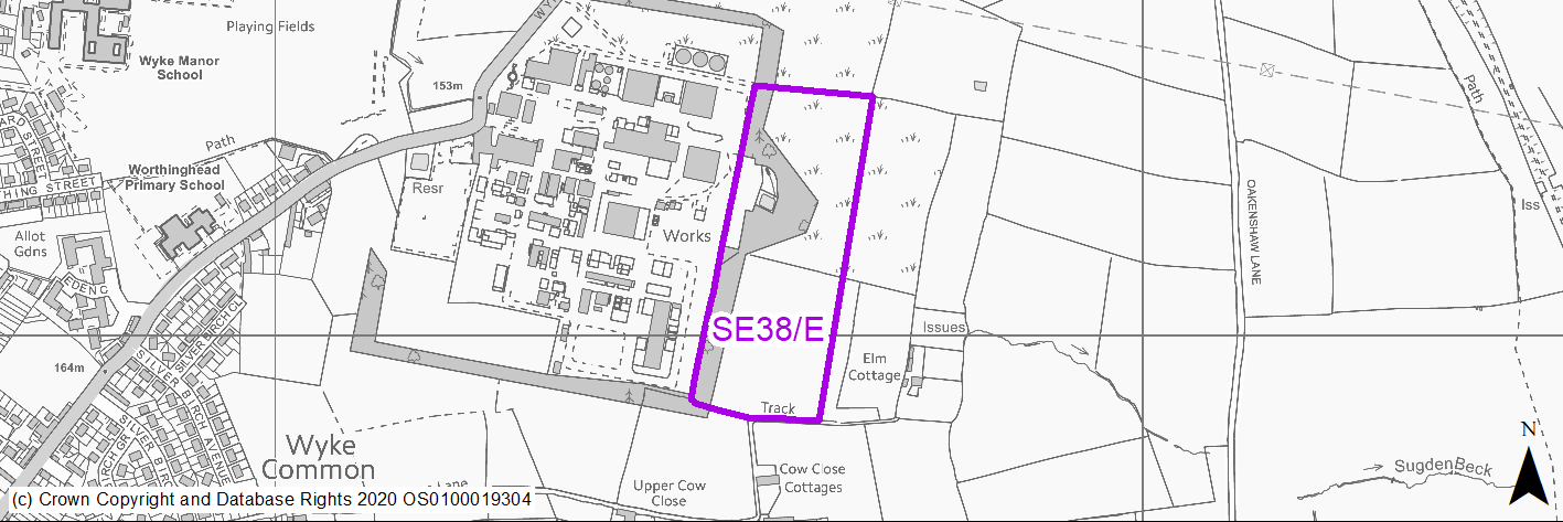
(4) SE38/E - AH Marks Works, Wyke Lane
Site location
Regional City - Bradford SE
Ward
Wyke
Site description
Greenfield site adjacent to active chemical works
Proposed Allocation
Employment
SHLAA referencce
SE/148
Indicative no. dwellings
N/A
Site area (Gross) (ha)
5.42
Ownership
Private
Delivery timescales
2035-2038
Type (PDL/Greenfield)
Greenfield - 100%
Green Belt
No
Flood Zone
Flood Zone 1 - low risk of flooding.
Potential site access
There is no direct access to this site. It is probably most suitable for expansion of Nufarm complex.
Public Transport Accessibility
Bus Stop outside 400m frequent service
Sustainability Appraisal
The site has been proposed for employment development, which would be likely to deliver a major boost to the range of local employment opportunities at this location whilst also providing a boost to the local economy. A major positive score has therefore been predicted for the employment and economy themed SA Objectives.
An area covering approximately 15% of the site is at medium or high risk of surface water flooding. It is unclear if this could be entirely avoided through a careful layout of the development, and therefore a second major adverse effect has been predicted for the climate change resilience SA Objective.
Minor positive effects were predicted for a range of socio-economic themed SA Objectives due to the indirect benefits of a new employment site, such as the potential for increasing the local offering of services and amenities and opportunities to learn new skills.
The site is greenfield including trees and hedgerows, which would likely be lost in the development, and so minor adverse effects were predicted for a range of natural environment themed SA Objectives. There are two Grade II Listed Buildings within 120m of the site, the settings of which could be adversely affected by the development, particularly considering the size of the site.
Habitats Regulations Assessment
This site is beyond the zones of influence of the South Pennine Moors SPA/SAC and is therefore unlikely to have any significant effects, a HRA is not required.
Green Belt
N/A – Site not within the Green Belt.
Constraints and Opportunities
• Within Major Hazard Site Inner and Middle Zones - land is considered highly constrained and suitable for expansion land only for existing neighbouring use.
• Part of the site may be subject to surface water flooding.
• Hedgerow features to the west boundary.
• The site is within 150m of a landfill buffer.
• Former mining activities high risk development area to the extreme north west edge of the site which will require further investigation.
Development considerations
• No direct access to the site.
• Site may be suitable for expansion to Nufarm Chemical works subject to HSE agreement and planning approval.
Conclusion/Summary
Highly constrained site due to proximity to chemical works which may be suitable for expansion of existing operations, subject to relevant approvals.
Use Class
Class B2/B8
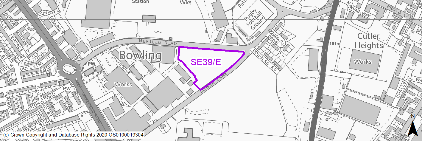
(1) SE39/E - Neville Road/ Lower Lane
Site location
Regional City - Bradford SE
Ward
Bowling and Barkerend
Site description
Partial outdoor storage and greened over brownfield site.
Proposed Allocation
Employment
SHLAA referencce
SE/151
Indicative no. dwellings
N/A
Site area (Gross) (ha)
1.57
Ownership
Private
Delivery timescales
2025-30
Type (PDL/Greenfield)
PDL - 80% Greenfield - 20%
Green Belt
No
Flood Zone
Flood Zone 1 - low risk of flooding.
Potential site access
There is an established access immediately to the west of the site off Neville Road.
Public Transport Accessibility
Bus Stop within 400m Frequent service
Sustainability Appraisal
The site has been proposed for employment development, which would be likely to deliver a major boost to the range of local employment opportunities at this location whilst also providing a boost to the local economy. A major positive score has therefore been predicted for the employment and economy themed SA Objectives.
A significant adverse effect has been predicted for the air quality SA Objective as a result of the site being situated entirely within the CAZ. Development here could potentially make achieving air quality improvement targets within the CAZ more difficult.
An additional major adverse effect arises for the climate change resilience SA Objective due to a large area in the centre of the site at medium and high risk of surface water flooding. Due to the relative size of this area, it may be difficult to avoid.
Minor positive effects were predicted for other socio-economic themed SA Objectives due to the additional benefits of a new employment site, such as the potential for increasing the local offering of services and amenities and opportunities to learn new skills.
The site is a mixture of brownfield and greenfield and minor adverse effects were predicted for a range of natural environment themed SA Objectives.
Habitats Regulations Assessment
This site is beyond the zones of influence of the South Pennine Moors SPA/SAC and is therefore unlikely to have any significant effects, a HRA is not required.
Green Belt
N/A – Site not within the Green Belt.
Constraints and Opportunities
• Located within BDZ.
• Potential surface water flooding risk in the centre of the site.
• Significant pockets of vegetation across the site.
• Evidence of previous works with possible decontamination of site required.
• Within landfill buffer.
• Former mining activities high risk development area are noted throughout the site which will require further investigation.
Development considerations
• Established access immediately to the west of the site off Neville Road.
• Integration of development with GI would strengthen scheme design in this visible location, together with manage potential surface water risks.
• BDZ investment location.
Conclusion/Summary
Strategically well-located employment site within BDZ which would benefit from an integrated approach to scheme design and environmental management.
Use Class
Class B2/B8
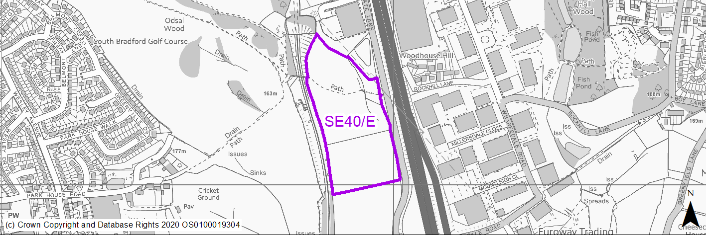
(6) SE40/E - Staithgate Lane North
Site location
Regional City - Bradford SE
Ward
Wyke
Site description
Agricultural land. Two industrial sheds have been recently constructed in the middle of the site, leaving available land in two parcels to the north and south.
Proposed Allocation
Employment
SHLAA referencce
SE/155
Indicative no. dwellings
N/A
Site area (Gross) (ha)
5.82
Ownership
Public
Delivery timescales
2020-25
Type (PDL/Greenfield)
Greenfield - 100%
Green Belt
No
Flood Zone
Flood Zone 1 - low risk of flooding.
Potential site access
Site access would need to be obtained from Staithgate Lane.
Public Transport Accessibility
Bus Stop outside 400m frequent service Outside 800m of Rail Station
Sustainability Appraisal
The site has been proposed for employment development, which would be likely to deliver a major boost to the range of local employment opportunities at this location whilst also providing a boost to the local economy. A major positive score has therefore been predicted for the employment and economy themed SA Objectives.
The site is within 300m of the CAZ, and due to the size of the proposed development it could potentially make achieving air quality improvement targets within the CAZ more difficult. As a result, a significant adverse effect has been predicted for the air quality SA Objective.
Minor positive effects were predicted for other socio-economic themed SA Objectives due to the additional benefits of a new employment site, such as the potential for increasing the local offering of services and amenities and opportunities to learn new skills.
Minor adverse effects were predicted for a range of natural environment themed SA Objectives, primarily as a result of the impacts of new development on a greenfield site adjoining deciduous woodland priority habitat. There is a Grade II Listed Building 175m east of the site, and due to the proposed size of the development, the setting of this could be adversely altered.
Habitats Regulations Assessment
This site is beyond the zones of influence of the South Pennine Moors SPA/SAC and is therefore unlikely to have any significant effects, a HRA is not required.
Green Belt
N/A – Site not within the Green Belt.
Constraints and Opportunities
• Forms part of the Bradford Enterprise Zone.
• Deciduous woodland (Odsal Wood) immediately north-west of site.
• Hedgerow material within and along the boundaries of the site.
• Within GI corridor.
• Entire site contains landfill with high risk of former coal mining activities across the whole site.
• Within outer HSE zone.
• Identified as potential open land within settlements open space designation.
• Identified as part of the grassland habitat network.
• Heritage assets within 175m of the site.
Development considerations
• Site access from Staithgate Lane.
• Forms part of the Bradford Enterprise Zone.
• Prime employment location adjacent to M606.
• Sensitive approach to scheme design required in consideration of landscape and GI infrastructure.
• Site likely to require extensive investigative works and site remediation.
• Designated Enterprise Zone.
Conclusion/Summary
Strategically well-located employment site within Enterprise Zone - opportunity for sensitive landscape, GI and open space treatment as part of a quality gateway site.
Use Class
Class B2/B8
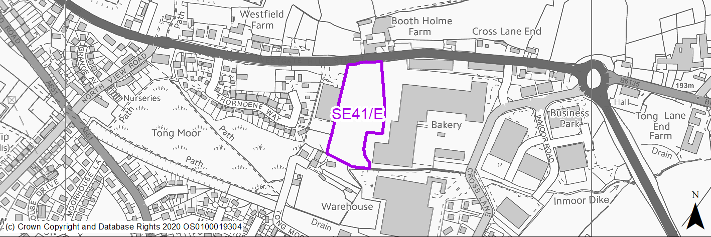
(3) SE41/E - Westgate Hill Street
Site location
Regional City - Bradford SE
Ward
Tong
Site description
Greenfield edge of industrial site location.
Proposed Allocation
Employment
SHLAA referencce
SE/152
Indicative no. dwellings
N/A
Site area (Gross) (ha)
1.5
Ownership
Private
Delivery timescales
2025-30
Type (PDL/Greenfield)
Greenfield - 100%
Green Belt
No
Flood Zone
Flood Zone 1 - low risk of flooding.
Potential site access
No access constraints for cars or HGVs.
Public Transport Accessibility
Bus Stop within 400m infrequent service
Sustainability Appraisal
The site has been proposed for employment development, which would be likely to deliver a major boost to the range of local employment opportunities at this location whilst also providing a boost to the local economy. A major positive score has therefore been predicted for the employment and economy themed SA Objectives.
Minor positive effects were predicted for other socio-economic themed SA Objectives due to the additional benefits of a new employment site, such as the potential for increasing the local offering of services and amenities and opportunities to learn new skills.
No major adverse effects have been predicted for the site, but minor adverse effects were predicted for a range of natural environment themed SA Objectives, primarily as a result of the impacts of new development on a 100% greenfield site, which adjoins Tong Moor LNR and LWS. The southern perimeter is adjacent to Inmoor Dike, the water quality of which could be impacted by the development.
Habitats Regulations Assessment
This site is beyond the zones of influence of the South Pennine Moors SPA/SAC and is therefore unlikely to have any significant effects, a HRA is not required.
Green Belt
N/A – Site not within the Green Belt.
Constraints and Opportunities
• Site forms part of the grassland habitat network and GI corridor.
• Within landfill buffer and with high risk of former mining activities across the site.
• Situated close to the Tong Moor NR.
• Potential impact on residential properties adjoining the southern boundary.
• Active and successful industrial employment area.
• Former mining activities high risk development area are noted through approximately 75% of the site which will require further investigation.
Development considerations
• Access from Westgate Lane Street.
• Extension of environmental buffer to screen residential properties to the south.
• Potential site remediation with detailed site investigative works required.
• Integration of habitat and GI connectivity through the site.
Conclusion/Summary
Prime highway fronting employment site option - with potential to integrate landscape, habitat and GI networks.
Use Class
Class B2/B8
(4) SE42/E - Staithgate Lane South
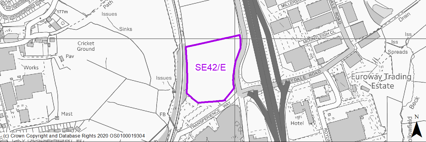
Site location
Regional City - Bradford SE
Ward
Wyke
Site description
Greenfield edge of industrial site within employment established employment corridor.
Proposed Allocation
Employment
SHLAA referencce
SE/155
Indicative no. dwellings
N/A
Site area (Gross) (ha)
2.87
Ownership
Public
Delivery timescales
2020-25
Type (PDL/Greenfield)
Greenfield - 100%
Green Belt
No
Flood Zone
Flood Zone 1 - low risk of flooding.
Potential site access
No major site access constraints identified.
Public Transport Accessibility
Within 800m of Rail Station
Sustainability Appraisal
The site has been proposed for employment development, which would be likely to deliver a major boost to the range of local employment opportunities at this location whilst also providing a boost to the local economy. A major positive score has therefore been predicted for the employment and economy themed SA Objectives.
Minor positive effects were predicted for other socio-economic themed SA Objectives due to the additional benefits of a new employment site, such as the potential for increasing the local offering of services and amenities and opportunities to learn new skills.
No major adverse effects have been predicted for the site, but minor adverse effects were predicted for a range of natural environment themed SA Objectives, primarily as a result of the impacts of new development on a 100% greenfield site. There are three areas designated as LWS, LNR and/or deciduous woodland priority habitat within 30m of the site, which could be adversely affected by development here. A small surface waterbody is 60m east of the site; new development could pose a risk to the water quality.
Habitats Regulations Assessment
This site is beyond the zones of influence of the South Pennine Moors SPA/SAC and is therefore unlikely to have any significant effects, a HRA is not required.
Green Belt
N/A – Site not within the Green Belt.
Constraints and Opportunities
• Forms part of the Bradford Enterprise Zone.
• Immediately on the opposite site of the railway line are the Railway Terrace / Raw Nook LNR & BWA.
• Toad Holes Beck immediately south of the site.
• Within GI corridor and hedgerows around the entire boundary of the site.
• Partly within middle and outer HSE zones.
• Identified as potential open land within settlements open space designation.
• Identified as part of the grassland habitat network.
• Heritage assets within 175m of the site.
• The Open Space Assessment identified green space immediately to the east and west.
• Site contains former iron and coal pit and landfill throughout with significant sections of the site containing high risk mining area.
Development considerations
• Site access from Staithgate Lane.
• Forms part of the Bradford Enterprise Zone.
• Prime employment location adjacent to M606.
• Sensitive approach to scheme design required in consideration of landscape and GI infrastructure.
• Site likely to require extensive investigative works and remediation.
• Designated Enterprise Zone.
Conclusion/Summary
Strategically well-located employment site within Enterprise Zone - opportunity for sensitive landscape, GI and open space treatment as part of a quality gateway site.
Use Class
Class B2/B8
(2) SE43/E - Dick Lane
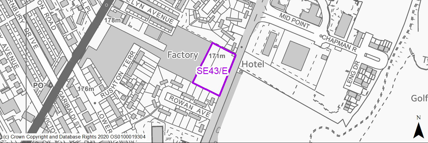
Site location
Regional City - Bradford SE
Ward
Bradford Moor
Site description
Greened over site in front of an industrial shed, with access road running through east to west.
Proposed Allocation
Employment
SHLAA referencce
SE/149
Indicative no. dwellings
N/A
Site area (Gross) (ha)
0.55
Ownership
Private
Delivery timescales
2025-30
Type (PDL/Greenfield)
Greenfield - 100%
Green Belt
No
Flood Zone
Flood Zone 1 - low risk of flooding.
Potential site access
No major access constraints identified.
Public Transport Accessibility
Bus Stop within 400m Frequent service
Sustainability Appraisal
The site has been proposed for employment development, which would be likely to deliver a major boost to the range of local employment opportunities at this location whilst also providing a boost to the local economy. A major positive score has therefore been predicted for the employment and economy themed SA Objectives.
Minor positive effects were predicted for other socio-economic themed SA Objectives due to the additional benefits of a new employment site, such as the potential for increasing the local offering of services and amenities and opportunities to learn new skills.
No major adverse effects have been predicted for the site, but minor adverse effects were predicted for a range of natural environment themed SA Objectives, primarily as a result of the impacts of new development on a predominantly greenfield site.
Habitats Regulations Assessment
This site is beyond the zones of influence of the South Pennine Moors SPA/SAC and is therefore unlikely to have any significant effects, a HRA is not required.
Green Belt
N/A – Site not within the Green Belt.
Constraints and Opportunities
• Within landfill buffer.
• Situated directly adjacent to established business use.
• Residential properties to the north and south.
Development considerations
• Access from Dick Lane.
• Environmental buffer required to protect nearby residential properties.
Conclusion/Summary
Small local employment option site within mixed commercial and residential area, which should be considered as part of scheme design.
Use Class
Class B2/B8
(2) SE44/E - Shetcliffe Lane
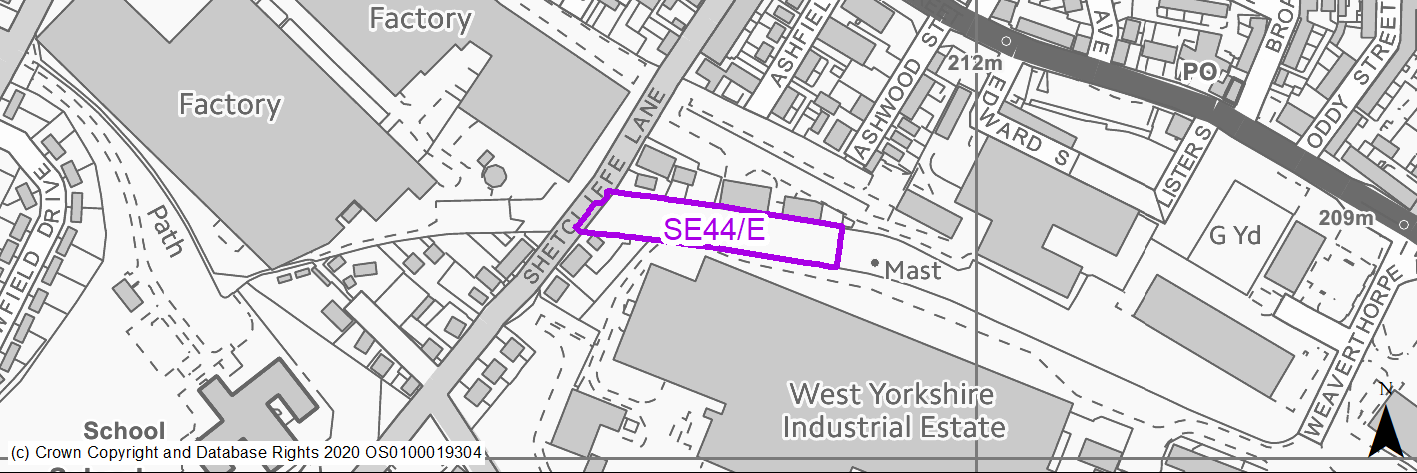
Site location
Regional City - Bradford SE
Ward
Tong
Site description
Hardstanding between industrial units - limited storage use
Proposed Allocation
Employment
SHLAA referencce
N/A
Indicative no. dwellings
N/A
Site area (Gross) (ha)
0.42
Ownership
Private
Delivery timescales
2030-35
Type (PDL/Greenfield)
PDL - 100%
Green Belt
No
Flood Zone
Flood Zone 1 - low risk of flooding.
Potential site access
Established access off Shetcliiffe Lane.
Public Transport Accessibility
Bus Stop within 400m Frequent service
Sustainability Appraisal
See individual Sustainability Appraisal site comment in the accompanying report.
Habitats Regulations Assessment
This site is beyond the zones of influence of the South Pennine Moors SPA/SAC and is therefore unlikely to have any significant effects, a HRA is not required.
Green Belt
N/A – Site not within the Green Belt.
Constraints and Opportunities
• Small linear site within established industrial area.
• Evidence of previous use - land may require remediation.
• Very narrow development platform - may reduce commercial interest.
• Former mining activities high risk development area are noted for the whole of the site which will require further investigation.
Development considerations
• Potential risk of limited surface water flooding across part of the site.
Conclusion/Summary
Small linear employment site within established industrial area - potentially suitability for small business use.
Use Class
Class B2/B8
(1) SE1/H - Highbridge Terrace, West Bowling
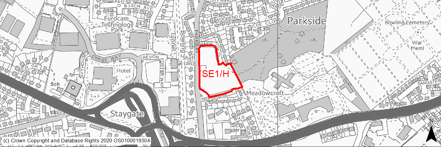
Site location
Regional City - Bradford SE
Ward
Little Horton
Site description
Informal open space, historically the site of tower blocks. Allocated housing site in RUDP.
Proposed Allocation
Housing
SHLAA referencce
SE/001
Indicative no. dwellings
30
Site area (Gross) (ha)
1.32
Ownership
Council
Delivery timescales
Developable (6-10 years)
Type (PDL/Greenfield)
Greenfield
Green Belt
No
Flood Zone
Flood Zone 1
Potential site access
No access issues.
Public Transport Accessibility
Bus Stop within 400m of Service 508 which is a frequent service.
Sustainability Appraisal
The site could deliver major positive effects for residents on both the health and education SA Objectives as a result of being within the target distances for all necessary health facilities and centres for primary and secondary education. A significant adverse effect has been predicted for the air quality SA Objective as a result of the site being situated entirely within the CAZ. Development here could potentially make achieving air quality improvement targets within the CAZ more difficult. Minor positive effects were predicted for most socio-economic themed SA Objectives due to the benefits of new residential development for the local economy as well as the location of the site in relation to transport links, local services and amenities, and employment areas.
Minor adverse effects were predicted for a range of natural environment themed SA Objectives, primarily as a result of the impacts of new development on a 100% greenfield site adjacent to deciduous woodland priority habitat.
Habitats Regulations Assessment
This site is beyond the zones of influence of the South Pennine Moors SPA/SAC and is therefore unlikely to have any significant effects, a HRA is not required.
Green Belt
N/A – Site not within the Green Belt.
Constraints and Opportunities
• The southern part of the site slopes steeply in part.
• The site is of value to the local community as open space.
• The site is developable and lies in a sustainable location with good access to a number of other large areas of open space.
• Within landfill buffer – further investigation required.
• Majority of the site within high risk former mining activities area with further investigation required.
Development considerations
• The development of the site should retain some on site open space.
• PROW within the eastern edge of the site and environmental buffer or corridor may be required due to close proximity to woodland to the east.
Conclusion/Summary
The site is currently used as informal open space and whilst it can accommodate a higher number of homes, an area should be retained to create a corridor to the wooded area to the east of the site. The site should deliver at least 30 homes but has the potential for more subject to an acceptable layout which retains open space.
(3) SE2/H - Copgrove Road, Holme Wood
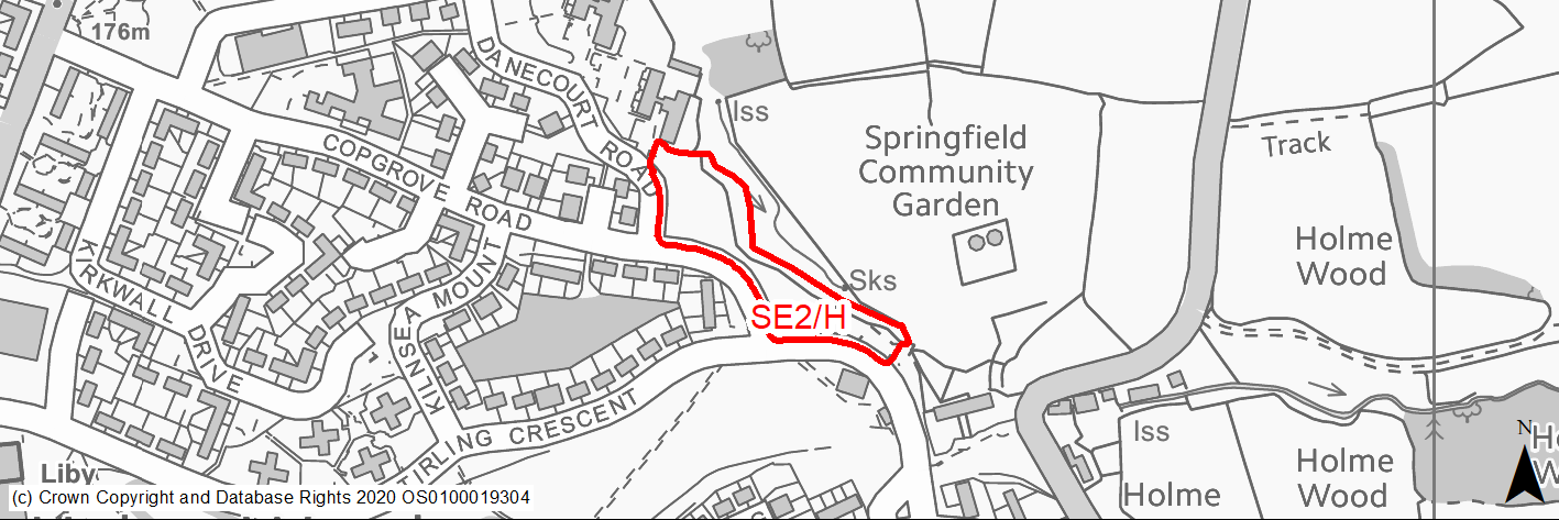
Site location
Regional City - Bradford SE
Ward
Tong
Site description
Unused green area fronting highway with measures to prevent vehicular access.
Proposed Allocation
Housing
SHLAA referencce
SE/003
Indicative no. dwellings
12
Site area (Gross) (ha)
0.56
Ownership
Council
Delivery timescales
Deliverable (0-5 years)
Type (PDL/Greenfield)
Greenfield
Green Belt
No
Flood Zone
Flood Zone 1
Potential site access
No access issues.
Public Transport Accessibility
Bus Stop within 400m Service 617/618 frequent service.
Sustainability Appraisal
The site could deliver a major positive effect for residents on the health SA Objective as a result of being within the target distances for all necessary health facilities. Minor positive effects were predicted for nearly all socio-economic themed SA Objectives due to the benefits of new residential development for the local economy as well as the location of the site in relation to transport links, local services and amenities, education facilities and employment areas.
No major adverse effects have been predicted for the site, but minor adverse effects were predicted for a range of natural environment themed SA Objectives, primarily as a result of the impacts of new development on a 100% greenfield site. There is a small waterbody 10m east of the site, which could be impacted by the construction and occupation of the site.
Habitats Regulations Assessment
This site is beyond the zones of influence of the South Pennine Moors SPA/SAC and is therefore unlikely to have any significant effects, a HRA is not required.
Green Belt
N/A – Site not within the Green Belt.
Constraints and Opportunities
• Forms part of a green infrastructure corridor – site frontage development only.
• Some evidence of surface water flood risk to the western site edge.
• Eastern aspects of the site within landfill buffer – further investigations may be required.
Development considerations
• The site fronts Copgrove Road and can accommodate a row of traditional housing with gardens.
• Additional planting in rear garden areas will enhance the wooded area to the east.
• Maintaining links within green infrastructure corridor should be encouraged.
Conclusion/Summary
The site is level and greenfield but attracts anti social behaviour. It should accommodate a sensitively designed development of homes with rear gardens which overlook the semi wooded area to the east. The site boundary has been reduced to exclude the wooded slope from the development site. The design of future development should enhance this area by further planting along rear garden boundaries.
(3) SE3/H - Cleckheaton Road
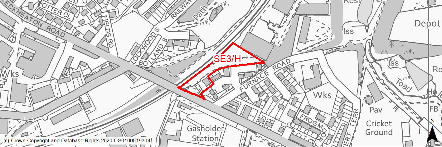
Site location
Regional City - Bradford SE
Ward
Wyke
Site description
Former railway siding with some self seeded trees. The site was previously used by the Transperience museum
Proposed Allocation
Housing
SHLAA referencce
SE/005
Indicative no. dwellings
16
Site area (Gross) (ha)
0.51
Ownership
Council/Private
Delivery timescales
Deliverable (0-5 years)
Type (PDL/Greenfield)
PDL
Green Belt
No
Flood Zone
Flood Zone 1
Potential site access
Access from existing estate, although this may need to be widened.
Public Transport Accessibility
Site within 800m of Low Moor Rail Station. Bus stops within 400m.
Sustainability Appraisal
Major adverse effects due to proximity of the site to major hazards (middle and outer zones). The site could deliver a major positive effect for residents on the transport SA Objective as a result of being within the target distances of both bus stops and a railway station.
Minor positive effects were predicted for most other socio-economic themed SA Objectives due to the benefits of new residential development for the local economy as well as the location of the site in relation to education facilities, local services and amenities, and employment areas. However, the site is adjacent to a railway track so residents may experience some disruption.
The site is PDL but appears now to have a high percentage woodland cover, with the northern portion of the site coincident with the Railway Terrace / Raw Nook Local Nature Reserve. It is unclear if the new development would avoid the LNR. As such, minor adverse effects have been predicted for a range of natural environment themed SA Objectives, but there are no significant adverse effects predicted for the site.
Habitats Regulations Assessment
This site is beyond the zones of influence of the South Pennine Moors SPA/SAC and is therefore unlikely to have any significant effects, a HRA is not required.
Green Belt
N/A – Site not within the Green Belt.
Constraints and Opportunities
• Site is previously developed and provides an opportunity to regenerate an urban site in the urban area.
• The site does contain areas of semi mature trees which are a mixture of self seeded and mature.
• Located within Major Hazard Middle and Outer Zones.
• Part of wider green infrastructure corridor.
• Boundary of Railway Terrace / Raw Nook LNR technically within site.
• Part of the southern section of the site within high risk former mining activities area with further investigation required.
Development considerations
• Site access is available off existing estate.
• The development of the site should retain trees where possible.
• Development parcels within the overall site should avoid impact on the LNR.
Conclusion/Summary
The site is level and previously developed and in a sustainable location close to bus routes and the Low Moor railway station. It could deliver 16 family homes or an apartment block on defined sections of the site outside the LNR. Where possible mature trees should be retained with strong landscaping to the north western edge adjacent to the railway line and LNR.
(6) SE4/H - Spen View Lane/Shetcliffe Lane, Bierley
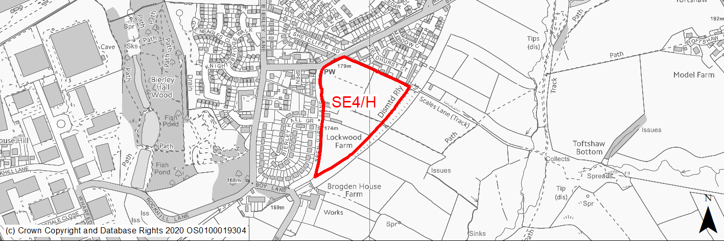
Site location
Regional City - Bradford SE
Ward
Tong
Site description
Fields currently used for horse grazing and farm buildings. Generally level with raised former railway line banking to the south west.
Proposed Allocation
Housing
SHLAA referencce
SE/014
Indicative no. dwellings
100
Site area (Gross) (ha)
3.77
Ownership
Private
Delivery timescales
Deliverable (0-5 years)
Type (PDL/Greenfield)
Greenfield
Green Belt
No
Flood Zone
Flood Zone 1
Potential site access
Access from Shetcliffe Lane.
Public Transport Accessibility
Bus Stop within 400m with a frequent service.
Sustainability Appraisal
No significant adverse effects predicted. Minor adverse effects predicted for most natural environment themed SA Objectives, primarily as a result of the effects associated with development on greenfield. Minor adverse effects predicted for historic environment in light of listed buildings within site boundary. The site is generally well located to provide residents with good access to buses, jobs, cultural spaces, and schools, with particularly good access to health facilities. For some key services and amenities, such as shops, residents may need to travel up to 1km.
Habitats Regulations Assessment
This site is beyond the zones of influence of the South Pennine Moors SPA/SAC and is therefore unlikely to have any significant effects, a HRA is not required.
Green Belt
N/A – Site not within the Green Belt.
Constraints and Opportunities
• Access is available from Shetcliffe Lane.
• Cluster of listed buildings within the centre and western edge of the site and further analysis is required on heritage impact.
• The site has some drainage issues in part and evidence of potential surface water flooding along eastern edge.
• Small area within the north west of the site within high risk former mining activities area with further investigation required.
Development considerations
• Heritage impact assessment required.
• Development should ensure that additional planting is provided along the former railway line and a buffer around the listed building.
Conclusion/Summary
The site is allocated for development in the RUDP and there has been significant interest from developers in bringing this site forward. A planning application on the northern section of the site is pending with further potential on the remainder. The site should deliver at least 100 homes, subject to heritage constraints.
(1) SE5/H - Upper Castle Street, West Bowling
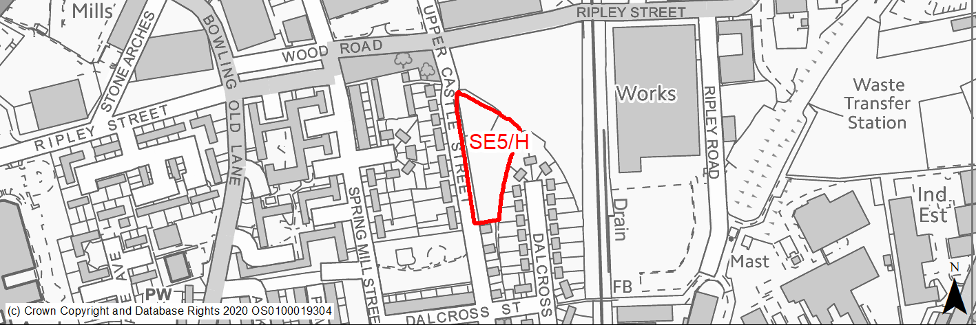
Site location
Regional City - Bradford SE
Ward
Little Horton
Site description
Vacant level, underused Land, with a number of small self seeded trees.
Proposed Allocation
Housing
SHLAA referencce
SE/015B
Indicative no. dwellings
17
Site area (Gross) (ha)
0.43
Ownership
Private
Delivery timescales
Deliverable (0-5 years)
Type (PDL/Greenfield)
Greenfield
Green Belt
No
Flood Zone
Flood Zone 1
Potential site access
No access issues.
Public Transport Accessibility
Bus Stop within 400m Service 620/621 frequent service.
Sustainability Appraisal
Significant adverse effect predicted for the air quality SA Objective as a result of the site being within the CAZ. No other significant adverse effects predicted. Minor adverse effects predicted for most natural environment themed SA Objectives, primarily as a result of the effects associated with development on greenfield. The site is well located to provide residents with good access to buses, shops, jobs, and cultural spaces, with particularly good access to schools and health facilities.
Habitats Regulations Assessment
This site is beyond the zones of influence of the South Pennine Moors SPA/SAC and is therefore unlikely to have any significant effects, a HRA is not required.
Green Belt
N/A – Site not within the Green Belt.
Constraints and Opportunities
• The site attracts anti social behaviour and is unmaintained greenspace.
• Site is within landfill buffer and further investigations may be required.
• Evidence of potential surface water flooding risk to western edge of the site.
• Southern third of the site within high risk former mining activities area with further investigation required.
Development considerations
• The site fronts the highway and could be developed in a linear form.
Conclusion/Summary
Greenfield site which is well located close to shops and services. The site could accommodate 17 homes.
(1) SE6/H - Rooley Lane
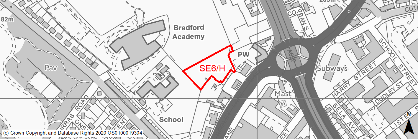
Site location
Regional City - Bradford SE
Ward
Bowling and Barkerend
Site description
Greenfield site to the rear of properties fronting Rooley Lane.
Proposed Allocation
Housing
SHLAA referencce
SE/027
Indicative no. dwellings
10
Site area (Gross) (ha)
0.5
Ownership
Council
Delivery timescales
Deliverable (0-5 years)
Type (PDL/Greenfield)
Greenfield
Green Belt
No
Flood Zone
Flood Zone 1
Potential site access
Accessing potential from Munster Street or Rooley Lane.
Public Transport Accessibility
Bus Stop within 400m Service 508 frequent service.
Sustainability Appraisal
Significant adverse effect predicted for the air quality SA Objective as a result of the site being within the CAZ. No other significant adverse effects predicted. Minor adverse effects predicted for most natural environment themed SA Objectives, primarily as a result of the effects associated with development on greenfield. The site is well located to provide residents with good access buses, shops, jobs, and cultural spaces, with particularly good access to schools and health facilities.
Habitats Regulations Assessment
This site is beyond the zones of influence of the South Pennine Moors SPA/SAC and is therefore unlikely to have any significant effects, a HRA is not required.
Green Belt
N/A – Site not within the Green Belt.
Constraints and Opportunities
• Site access to be resolved but options are available.
• Eastern half of the site within landfill buffer – further investigation may be required.
• Majority of the site within high risk former mining activities area with further investigation required.
Development considerations
• The site contains a number of trees/hedgerows which should be retained.
Conclusion/Summary
Underutilised greenfield site in a sustainable location. Access will need to be resolved and trees retained where possible but the site offers the potential to accommodate 10 homes, within close proximity to schooling.
(1) SE7/H - Landscove Avenue, Holme Wood
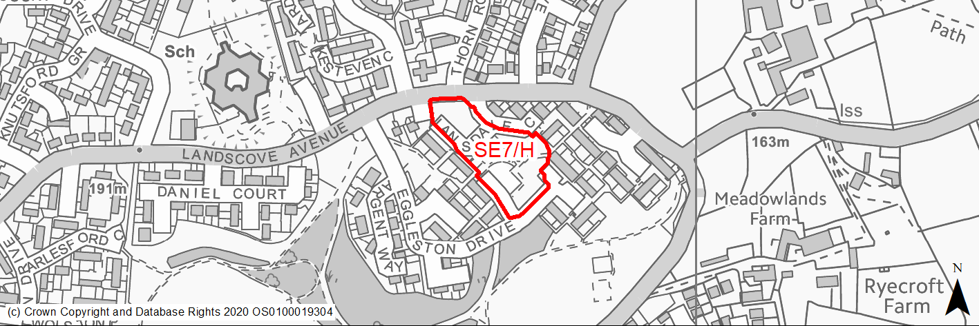
Site location
Regional City - Bradford SE
Ward
Tong
Site description
Cleared site with areas retained for parking and informal open space. Site contains some trees which mostly lie on boundaries.
Proposed Allocation
Housing
SHLAA referencce
SE/030
Indicative no. dwellings
20
Site area (Gross) (ha)
0.62
Ownership
Private
Delivery timescales
Deliverable (0-5 years)
Type (PDL/Greenfield)
Mixed
Green Belt
No
Flood Zone
Flood Zone 1
Potential site access
No access issues.
Public Transport Accessibility
Bus Stop within 400m Service 608 frequent service.
Sustainability Appraisal
The site could deliver a major positive effect for residents on the education SA Objective as a result of being within the target distance for both primary and secondary education facilities.
Minor positive effects were predicted for nearly all other socio-economic themed SA Objectives due to the benefits of new residential development for the local economy as well as the location of the site in relation to transport links, local services and amenities, education facilities and employment areas.
No major adverse effects have been predicted for the site, but minor adverse effects were predicted for a range of natural environment themed SA Objectives, primarily as a result of the impacts of new development on a site which is partially greenfield and contains some GI elements.
Habitats Regulations Assessment
This site is beyond the zones of influence of the South Pennine Moors SPA/SAC and is therefore unlikely to have any significant effects, a HRA is not required.
Green Belt
N/A – Site not within the Green Belt.
Constraints and Opportunities
• A large part of this site has been developed previously and its redevelopment provides the opportunity for further regeneration.
• Footpaths through the site.
• Part of wider green infrastructure corridor.
Development considerations
• The design should incorporate existing trees and hedges where possible.
• Layout should consider relationship with existing dwellings and development of defensible space and clear differentiation between public and private space.
Conclusion/Summary
Mixed greenfield/brownfield site which can accommodate at least 20 family homes or apartments around existing access roads. An area of land closest to Landscove Avenue which contains trees and shrubs should be retained.
(2) SE8/H - Grayswood Drive, Holme Wood
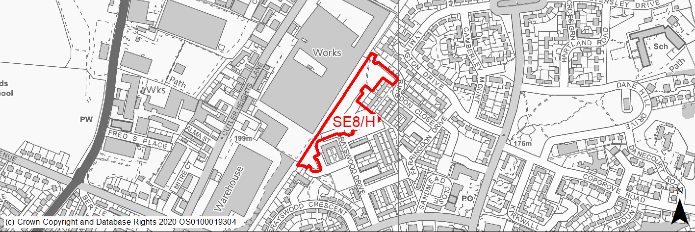
Site location
Regional City - Bradford SE
Ward
Tong
Site description
Amenity space between residential properties and former railway line. The land has had some development on it historically but the area is now semi maintained greenspace.
Proposed Allocation
Housing
SHLAA referencce
SE/031
Indicative no. dwellings
32
Site area (Gross) (ha)
1.02
Ownership
Private
Delivery timescales
Deliverable (0-5 years)
Type (PDL/Greenfield)
Greenfield
Green Belt
No
Flood Zone
Flood Zone 1
Potential site access
No access issues.
Public Transport Accessibility
Bus Stop within 400m with a frequent service.
Sustainability Appraisal
The site could deliver major positive effects for residents on both the health and education SA Objectives as a result of being within the target distances for all necessary health facilities and centres for primary and secondary education.
Minor positive effects were predicted for most other socio-economic themed SA Objectives due to the benefits of new residential development for the local economy as well as the location of the site in relation to transport links and employment areas.
No major adverse effects have been predicted for the site, but minor adverse effects were predicted for a range of natural environment themed SA Objectives, primarily as a result of the impacts of new development on a 100% greenfield site.
Habitats Regulations Assessment
This site is beyond the zones of influence of the South Pennine Moors SPA/SAC and is therefore unlikely to have any significant effects, a HRA is not required.
Green Belt
N/A – Site not within the Green Belt.
Constraints and Opportunities
• Mitigation required for large operational industrial unit adjoining western boundary.
• Site within landfill buffer and further investigations may be required.
• Southern third of the site within high risk former mining activities area with further investigation required.
Development considerations
• Additional landscaping will be required to mitigate against potential noise from industry adjacent.
• Layout should consider the retention of open space of an appropriate scale as part of the overall design.
Conclusion/Summary
Greenfield site which has some amenity value to local residents but in a sustainable with many other areas of open space. It can accommodate at least 32 homes. An area of open space should still be provided within the scheme design.
(1) SE9/H - Stoneyhurst Square, Holme Wood
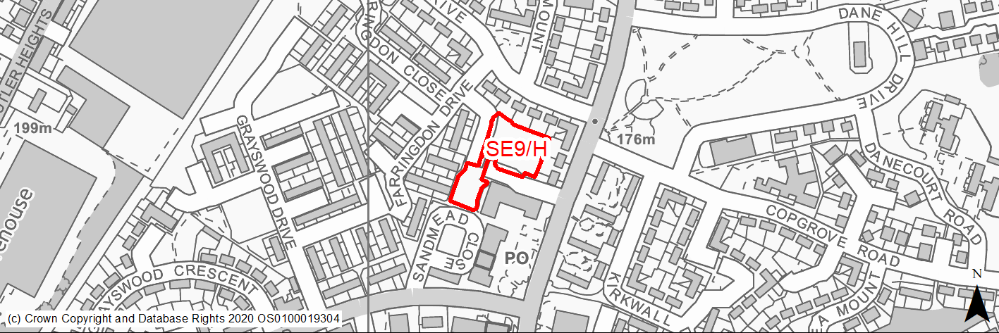
Site location
Regional City - Bradford SE
Ward
Tong
Site description
Underused greenspace between residential properties. Historically developed, now maintained as informal greenspace.
Proposed Allocation
Housing
SHLAA referencce
SE/032
Indicative no. dwellings
10
Site area (Gross) (ha)
0.31
Ownership
Private
Delivery timescales
Deliverable (0-5 years)
Type (PDL/Greenfield)
Greenfield
Green Belt
No
Flood Zone
Flood Zone 1
Potential site access
No access issues.
Public Transport Accessibility
Bus Stop within 400m with a frequent service.
Sustainability Appraisal
The site could deliver major positive effects for residents on both the health and education SA Objectives as a result of being within the target distances for all necessary health facilities and centres for primary and secondary education.
Minor positive effects were predicted for most other socio-economic themed SA Objectives due to the benefits of new residential development for the local economy as well as the location of the site in relation to transport links and employment areas.
No major adverse effects have been predicted, but as a greenfield site, it could currently be of some biodiversity value and be making a positive contribution to the local landscape and townscape character. This would be lost in the development, so minor adverse effects were predicted for a range of natural environment themed SA Objectives.
Habitats Regulations Assessment
This site is beyond the zones of influence of the South Pennine Moors SPA/SAC and is therefore unlikely to have any significant effects, a HRA is not required.
Green Belt
N/A – Site not within the Green Belt.
Constraints and Opportunities
• Site attracts anti social behaviour.
• No access constraints.
• Forms part of wider green infrastructure corridor.
• Majority of the site within high risk former mining activities area with further investigation required.
Development considerations
• Small area of open space to be retained and linked to wider green infrastructure routes through Holme Wood.
• Layout should consider relationship with existing dwellings and development of defensible space and clear differentiation between public and private space.
Conclusion/Summary
Underused informal greenspace. Site could accommodate up to 10 homes with the retention of a small area of open space.
(1) SE10/H - Land at Muirhead Fold, Holme Wood
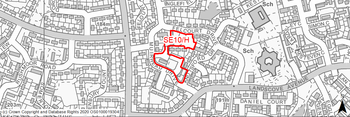
Site location
Regional City - Bradford SE
Ward
Tong
Site description
Mix of access roads, car parking and informal open space with some tree coverage.
Proposed Allocation
Housing
SHLAA referencce
SE/033
Indicative no. dwellings
19
Site area (Gross) (ha)
0.6
Ownership
Private
Delivery timescales
Developable (6-10 years)
Type (PDL/Greenfield)
Mixed
Green Belt
No
Flood Zone
Flood Zone 1
Potential site access
No access issues.
Public Transport Accessibility
Bus Stop within 400m with a frequent service.
Sustainability Appraisal
The site could deliver major positive effects for residents on both the health and education SA Objectives as a result of being within the target distances for all necessary health facilities and centres for primary and secondary education.
Minor positive effects were predicted for nearly all other socio-economic themed SA Objectives due to the benefits of new residential development for the local economy as well as the location of the site in relation to transport links, local services and amenities, and employment areas.
No major adverse effects have been predicted for the site, but minor adverse effects were predicted for a range of natural environment themed SA Objectives, primarily as a result of the impacts of new development on a partially greenfield site.
Habitats Regulations Assessment
This site is beyond the zones of influence of the South Pennine Moors SPA/SAC and is therefore unlikely to have any significant effects, a HRA is not required.
Green Belt
N/A – Site not within the Green Belt.
Constraints and Opportunities
• The development of this site provides an opportunity for regeneration and the provision of new low cost homes.
• Pockets of small open space.
Development considerations
• Walls and fencing backed by landscaping should be retained.
• Development has the potential to rationalise open space and provide a secure layout.
Conclusion/Summary
Greenfield site in sustainable area. The site has been previously developed but the formerly developed areas have been partly maintained as informal open space. The redevelopment of the site could accommodate family homes utilising the existing access roads.
(1) SE11/H - Bolling Hall Laundry, Off Rooley Lane
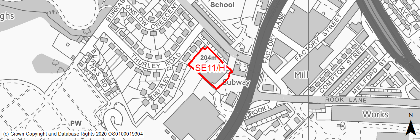
Site location
Regional City - Bradford SE
Ward
Bowling and Barkerend
Site description
Cleared PDL site, currently in use temporarily as vehicle storage.
Proposed Allocation
Housing
SHLAA referencce
SE/035
Indicative no. dwellings
18
Site area (Gross) (ha)
0.43
Ownership
Private
Delivery timescales
Developable (6-10 years)
Type (PDL/Greenfield)
PDL
Green Belt
No
Flood Zone
Flood Zone 1
Potential site access
No access issues.
Public Transport Accessibility
Bus Stop within 400m Service 508 frequent service.
Sustainability Appraisal
Significant adverse effect predicted for the air quality SA Objective, due to the site being within the CAZ. No other significant adverse effects predicted. SE/035 would be a good opportunity to deliver biodiversity net gains as well as improvements to the local townscape character. The site is well located to provide residents with good access to shops, buses, jobs, and cultural spaces, with particularly good access to schools and health facilities.
Habitats Regulations Assessment
This site is beyond the zones of influence of the South Pennine Moors SPA/SAC and is therefore unlikely to have any significant effects, a HRA is not required.
Green Belt
N/A – Site not within the Green Belt.
Constraints and Opportunities
• New tree planting in southern part of the site will improve air quality.
• Potential surface water flood risk along north western edge which require further analysis.
• About a third of the site towards the south east is within a high risk former mining activities area with further investigation required.
Development considerations
• Landscaping should be provided to mitigate against the impact of noise form adjacent supermarket delivery door.
Conclusion/Summary
Brownfield site in a sustainable location, close to bus routes and other local services. The site can accommodate at least 18 homes.
(3) SE12/H - Cordingley Street, Holme Wood
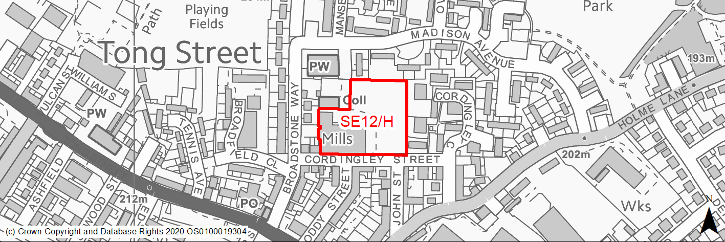
Site location
Regional City - Bradford SE
Ward
Tong
Site description
Underused mill and associated land.
Proposed Allocation
Housing
SHLAA referencce
SE/038
Indicative no. dwellings
36
Site area (Gross) (ha)
0.87
Ownership
Private
Delivery timescales
Developable (6-10 years)
Type (PDL/Greenfield)
PDL
Green Belt
No
Flood Zone
Flood Zone 1
Potential site access
No access issues.
Public Transport Accessibility
Bus Stop within 400m with a frequent service.
Sustainability Appraisal
The site could deliver major positive effects for residents on the health and education SA Objectives as a result of being within the target distances for all necessary health facilities and centres for primary and secondary education.
Minor positive effects were predicted for nearly all other socio-economic themed SA Objectives due to the benefits of new residential development for the local economy as well as the location of the site in relation to transport links, local services and amenities, and employment areas.
As a PDL site containing buildings, there are opportunities here for achieving biodiversity net gains and enhancing the local townscape character, depending on the design and implementation of the development.
The only adverse effects predicted for the site are minor and related to increases in air pollution and water consumption, which have been predicted at nearly all sites.
Habitats Regulations Assessment
This site is beyond the zones of influence of the South Pennine Moors SPA/SAC and is therefore unlikely to have any significant effects, a HRA is not required.
Green Belt
N/A – Site not within the Green Belt.
Constraints and Opportunities
• Site offers opportunity for a residential led scheme and potentially limited office use.
• Extreme southern edge of the site falls within a landfill buffer.
Development considerations
• The existing building on site is attractive and could be converted.
• Further detailed design required to inform finalised site yield.
Conclusion/Summary
Former mill building and land within the residential area. The building could be converted to residential led mixed use with new homes on the land. Site has potential for at least 36 homes, potentially more subject to capacity in the building.
(1519) SE13/H - Ned Lane, Holme Wood
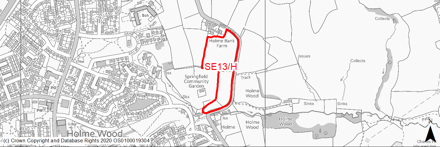
Site location
Regional City - Bradford SE
Ward
Tong
Site description
Fields in agricultural use with moderate slope north to south and some trees on eastern edge.
Proposed Allocation
Housing
SHLAA referencce
SE/046
Indicative no. dwellings
77
Site area (Gross) (ha)
2.92
Ownership
Council/Private
Delivery timescales
Developable (6-10 years)
Type (PDL/Greenfield)
Greenfield
Green Belt
Yes
Flood Zone
Flood Zone 1
Potential site access
Access from Ned Lane which will require improvement and widening.
Public Transport Accessibility
Bus Stop within 400m with a frequent service.
Sustainability Appraisal
See individual Sustainability Appraisal site comment in the accompanying report.
Habitats Regulations Assessment
This site is beyond the zones of influence of the South Pennine Moors SPA/SAC and is therefore unlikely to have any significant effects, a HRA is not required.
Green Belt
See individual Green Belt site assessment in the accompanying report.
Constraints and Opportunities
• The site should only be developed comprehensively with neighbouring sites SE31/H and SE18/H together with site SE45/H and informed by a detailed masterplan.
• The settings of listed buildings to both the north and south of the site are particularly sensitive and will require careful consideration, including heritage impact assessments.
• A buffer/area of open space will be required here to mitigate the impact of the development on these heritage assets.
• Majority of the site falls within landfill buffer and further investigations may be required.
• Site forms part of wider green infrastructure corridor considerations.
• Springfield community garden is situated to the west of the site.
Development considerations
• Road widening will require the approval of the Council as landowner.
• Heritage impact assessments.
• Comprehensive masterplan required in conjunction with neighbouring sites and in consideration of maintaining a strong Green Belt edge to the settlement, heritage impact considerations, road infrastructure constraints and changes in elevation through the site, together with wider green and community infrastructure connections.
Conclusion/Summary
Green belt site on the edge of the urban area contained by Ned Lane. The site should be developed comprehensively led by a masterplan with neighbouring sites to provide appropriately sensitive design, infrastructure, open space and landscaping.
(3) SE14/H - Albert Terrace, Oakenshaw
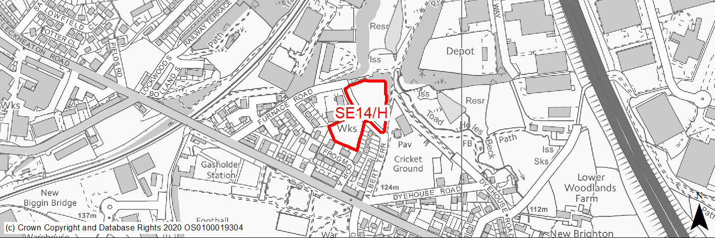
Site location
Regional City - Bradford SE
Ward
Wyke
Site description
Cleared land with some semi mature trees, bounded by woodland to north and east.
Proposed Allocation
Housing
SHLAA referencce
SE/048
Indicative no. dwellings
25
Site area (Gross) (ha)
0.8
Ownership
Private
Delivery timescales
Developable (6-10 years)
Type (PDL/Greenfield)
PDL
Green Belt
No
Flood Zone
Flood Zone 1
Potential site access
The site can be accessed from Frogmoor Avenue or Furnace Rd following the development of the adjacent site SE22/H.
Public Transport Accessibility
Bus Stop within 400m with a frequent service.
Sustainability Appraisal
Major adverse effects due to proximity of the site to chemical works (middle and outer zones). Minor adverse effects predicted for water resources and air quality SA Objectives, as predicted for nearly all other sites. Site has a small area of medium and high surface water flood risk in its eastern portion. The site is located adjacent to a Local Wildlife Site. The site would be a good opportunity to deliver biodiversity net gains and improvements to the local townscape character, given its current condition. The site is well located to provide residents here with good access to jobs, shops, and cultural spaces, with particularly good access to public transport options, schools and health facilities.
Habitats Regulations Assessment
This site is beyond the zones of influence of the South Pennine Moors SPA/SAC and is therefore unlikely to have any significant effects, a HRA is not required.
Green Belt
N/A – Site not within the Green Belt.
Constraints and Opportunities
• Development yield will be limited by location of the site in relating to the hazardous installation zones for the two chemical works in the area (Major Hazard Middle and Outer Zones).
• North western edge of the site within listed building 50m buffer.
• Site is within wider green infrastructure corridor.
• Western boundary towards centre of the site within high risk former mining activities area with further investigation required.
Development considerations
• Access will need to be determined - if from Frogmoor then deliverable in years 0-5.
• Trees should where possible be retained within the development, and as part of the wider green infrastructure corridor.
Conclusion/Summary
Brownfield site in a sustainable area with expired residential planning approval. The redevelopment of the site provides an opportunity to regenerate this part of Oakenshaw. Potential development yield will be limited by the location of the site in relation to HSE guidance.
(3) SE15/H - Proctor Street playing fields, Off Tong Street, Holme Wood
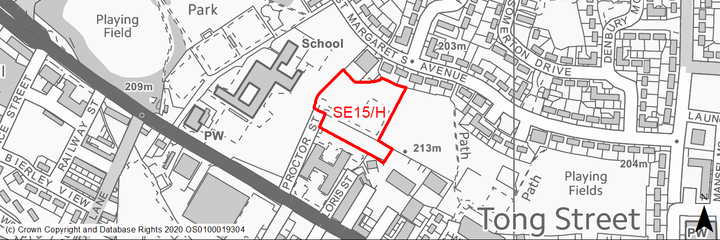
Site location
Regional City - Bradford SE
Ward
Tong
Site description
Unmaintained open space with some trees and hardstanding for now removed play area.
Proposed Allocation
Housing
SHLAA referencce
SE/050
Indicative no. dwellings
29
Site area (Gross) (ha)
0.74
Ownership
Council/Private
Delivery timescales
Deliverable (0-5 years)
Type (PDL/Greenfield)
Greenfield
Green Belt
No
Flood Zone
Flood Zone 1
Potential site access
Site can be accessed from end of Proctor Street.
Public Transport Accessibility
Bus Stop within 400m with a frequent service.
Sustainability Appraisal
The site could deliver major positive effects for residents on both the health and education SA Objectives as a result of being within the target distances for all necessary health facilities and centres for primary and secondary education.
Minor positive effects were predicted for nearly all other socio-economic themed SA Objectives due to the benefits of new residential development for the local economy as well as the location of the site in relation to transport links, local services and amenities, and employment areas.
No major adverse effects have been predicted for the site, but minor adverse effects were predicted for a range of natural environment themed SA Objectives, primarily as a result of the impacts of new development on a majority greenfield site containing trees.
Habitats Regulations Assessment
This site is beyond the zones of influence of the South Pennine Moors SPA/SAC and is therefore unlikely to have any significant effects, a HRA is not required.
Green Belt
N/A – Site not within the Green Belt.
Constraints and Opportunities
• Opportunity for increased tree planting along the western boundary.
• Major Hazard Gas Pipe immediately to western boundary of the site.
• Forms part of the wider green infrastructure network.
• Within landfill buffer for which further investigative analysis may be required.
• Borders amenity greenspace to the east.
• Small area towards the extreme south east of the site within high risk former mining activities area with further investigation required.
Development considerations
• Access is available from Proctor Street.
• Scheme layout will need to consider proximity and relationship to open space to the east and as part of its wider green infrastructure corridor setting.
Conclusion/Summary
Greenfield site with good access from Proctor Street. The site is in a sustainable location in the urban area with good access to services.
(2) SE16/H - Holme Lane, Holme Wood
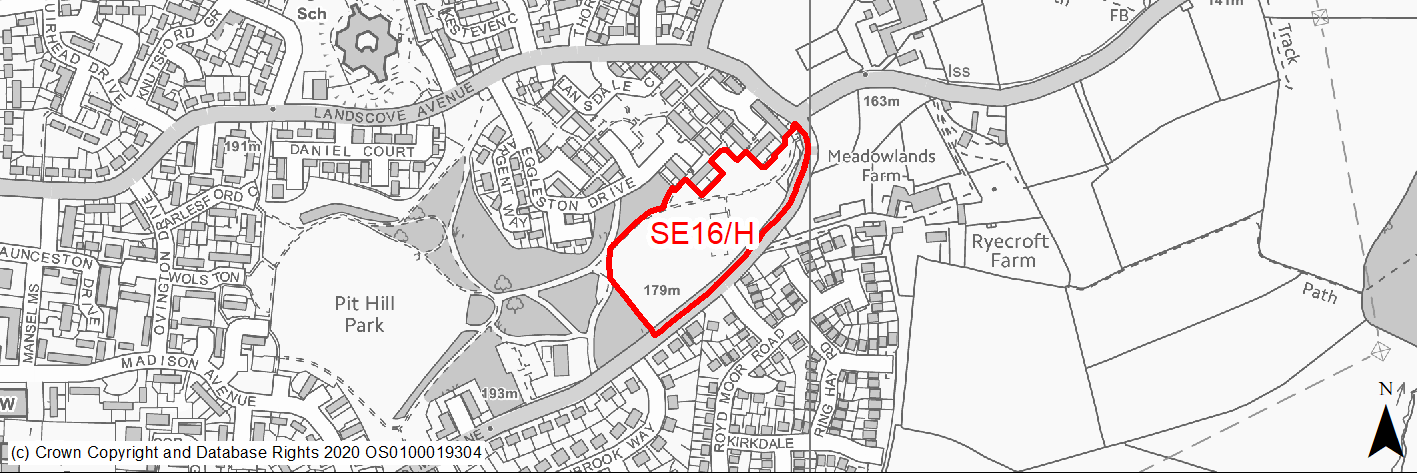
Site location
Regional City - Bradford SE
Ward
Tong
Site description
Open land used for informal open space containing trees and other ecological assets.
Proposed Allocation
Housing
SHLAA referencce
SE/051
Indicative no. dwellings
40
Site area (Gross) (ha)
1.67
Ownership
Council
Delivery timescales
Developable (6-10 years)
Type (PDL/Greenfield)
Greenfield
Green Belt
No
Flood Zone
Flood Zone 1
Potential site access
Site can be accessed from Holme Lane. Additional drainage measures for run off may be required.
Public Transport Accessibility
Bus Stop within 400m with a frequent service.
Sustainability Appraisal
The site could deliver a major positive effect for residents on the education SA Objective as a result of being within the target distance for both primary and secondary education facilities.
Minor positive effects were predicted for nearly all other socio-economic themed SA Objectives due to the benefits of new residential development for the local economy as well as the location of the site in relation to transport links, local services and amenities, health facilities and employment areas.
No major adverse effects have been predicted for the site, but minor adverse effects were predicted for a range of natural environment themed SA Objectives, primarily as a result of the impacts of new development on a predominantly greenfield site containing trees. There is a Grade II* and six Grade II Listed Buildings within 160m of the site, the settings of which could be adversely altered by development at the site.
Habitats Regulations Assessment
This site is beyond the zones of influence of the South Pennine Moors SPA/SAC and is therefore unlikely to have any significant effects, a HRA is not required.
Green Belt
N/A – Site not within the Green Belt.
Constraints and Opportunities
• Site contributes to Wildlife Habitat corridor.
• PROW through parts of the site.
• Part of a wider green infrastructure corridor.
• Potential risk of surface water flooding along eastern boundary which may require further consideration.
• Environmental buffers may be required in light of the existing woodland.
• Northern / eastern section of the site falls within a landfill buffer and further investigation may be required.
Development considerations
• Ecological mitigation will be required as the site contains mixed deciduous wood and hedgerow.
• Scheme layout will need careful consideration in light of ecological assets, PROW network and the need to design to a secure standard given proximity to neighbouring woodland.
Conclusion/Summary
Greenfield site where the boundary has been revised to remove the areas of significant tree cover. Trees and hedgerows along the site frontage should be retained and enhanced and pedestrian access through the site with additional planting will be encouraged. The site represents an opportunity for new development and should be able to accommodate at least 40 homes.
(2) SE17/HC - Kesteven Road/Heysham Drive, Holme Wood
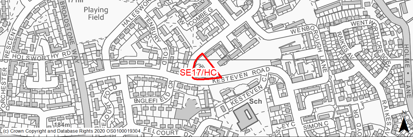
Site location
Regional City - Bradford SE
Ward
Tong
Site description
Cleared site, formerly public house.
Proposed Allocation
Housing
SHLAA referencce
SE/054
Indicative no. dwellings
11
Site area (Gross) (ha)
0.21
Ownership
Private
Delivery timescales
Deliverable (0-5 years)
Type (PDL/Greenfield)
PDL
Green Belt
No
Flood Zone
Flood Zone 1
Potential site access
No access issues.
Public Transport Accessibility
Bus Stop within 400m with a frequent service.
Sustainability Appraisal
The site could deliver major positive effects for residents on both the health and education SA Objectives as a result of being within the target distances for all necessary health facilities and centres for primary and secondary education.
Minor positive effects were predicted for nearly all other socio-economic themed SA Objectives due to the benefits of new residential development for the local economy as well as the location of the site in relation to transport links, local services and amenities, and employment areas.
The site is PDL containing a building which appears to be derelict, so residential development here could be an efficient use of land and provide opportunities to deliver biodiversity net gains. New development could ensure that the site has a more positive influence on the local townscape character.
The only adverse effects predicted for the site are minor and related to increases in air pollution and water consumption, which have been predicted at nearly all sites.
Habitats Regulations Assessment
This site is beyond the zones of influence of the South Pennine Moors SPA/SAC and is therefore unlikely to have any significant effects, a HRA is not required.
Green Belt
N/A – Site not within the Green Belt.
Constraints and Opportunities
• Previously developed land.
• Part of a wider green infrastructure network.
• The site has outline permission with principle of development accepted.
Development considerations
• Visible site which needs to be designed to strengthening the street frontage.
• Need to avoid over-development of the site and has the potential to contribute to the wider green infrastructure networks within Holme Wood.
Conclusion/Summary
Cleared site, formerly public house with outline permission for 11 homes - redevelopment will make a positive contribution to the delivery of new homes in Holme Wood and address a currently unattractive site.
(1512) SE18/H - Ned Lane, Holme Wood

Site location
Regional City - Bradford SE
Ward
Tong
Site description
Sloping fields in agricultural use.
Proposed Allocation
Housing
SHLAA referencce
SE/055
Indicative no. dwellings
98
Site area (Gross) (ha)
3.73
Ownership
Council
Delivery timescales
Developable (6-10 years)
Type (PDL/Greenfield)
Greenfield
Green Belt
Yes
Flood Zone
Flood Zone 1
Potential site access
Access from Ned Lane which will require improvement and widening.
Public Transport Accessibility
Bus Stop within 400m with a frequent service.
Sustainability Appraisal
See individual Sustainability Appraisal site comment in the accompanying report.
Habitats Regulations Assessment
This site is beyond the zones of influence of the South Pennine Moors SPA/SAC and is therefore unlikely to have any significant effects, a HRA is not required.
Green Belt
See individual Green Belt site assessment in the accompanying report.
Constraints and Opportunities
• The site should only be developed comprehensively with neighbouring sites SE13/H and SE31/H, together with site SE45/H and informed by a detailed masterplan.
• The settings of listed buildings to the north east / east of the site are particularly sensitive and will require careful consideration, including heritage impact assessments.
• Forms part of the wider green infrastructure network.
• Springfield Community Garden immediately to the south of the site and school playing fields to the north west.
• Potential scope for surface water flooding along western edge of the site will require further analysis.
• A buffer/area of open space will be required here to mitigate the impact of the development on these heritage assets.
• Significant proportion of the top of the site is within coal mining activities high risk area, together with far eastern edge, which will need to be subject to further investigation.
Development considerations
• Road widening will require the approval of the Council as landowner.
• Heritage impact assessments
• Further investigative works required in relation to coal mining risks and activities.
• Comprehensive masterplan required in conjunction with neighbouring sites and in consideration of maintaining a strong Green Belt edge to the settlement, heritage impact considerations, road infrastructure constraints and changes in elevation through the site, together with wider green and community infrastructure connections.
Conclusion/Summary
Green Belt site on the edge of the urban area contained by Ned Lane. The site should be developed comprehensively led by a masterplan with neighbouring sites to provide appropriately sensitive design, infrastructure, open space and landscaping.
(5) SE19/H - Westgate Hill Street Tong
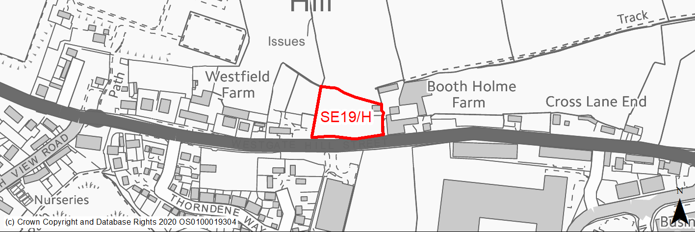
Site location
Regional City - Bradford SE
Ward
Tong
Site description
Vacant unused land.
Proposed Allocation
Housing
SHLAA referencce
SE/063
Indicative no. dwellings
7
Site area (Gross) (ha)
0.47
Ownership
Private
Delivery timescales
Developable (6-10 years)
Type (PDL/Greenfield)
Greenfield
Green Belt
No
Flood Zone
Flood Zone 1
Potential site access
No access issues.
Public Transport Accessibility
Bus Stop within 400m with a frequent service.
Sustainability Appraisal
The site could deliver a major positive effect for residents on the education SA Objective as a result of being within the target distance for both primary and secondary education facilities.
Minor positive effects were predicted for most socio-economic themed SA Objectives due to the benefits of new residential development for the local economy as well as the location of the site in relation to transport links, local services and amenities, health facilities and employment areas.
No major adverse effects have been predicted for the site, but minor adverse effects were predicted for a range of natural environment themed SA Objectives, primarily as a result of the impacts of new development on a 100% greenfield site which is 130m north of the Tong Moor LWS and LNR. Two small surface waterbodies are within 100m of the site, the water quality of which could be at risk from the development.
Habitats Regulations Assessment
This site is beyond the zones of influence of the South Pennine Moors SPA/SAC and is therefore unlikely to have any significant effects, a HRA is not required.
Green Belt
N/A – Site not within the Green Belt.
Constraints and Opportunities
• Site could be required to provide secondary access to neighbouring sites which has reduced its technical yield.
• Site forms part of the wider semi-improved neutral grassland habitat.
• Forms part of the green infrastructure network, with related considerations.
• Prime site frontage location.
• The site has previously had outline permission with principle of development previously accepted.
• Over 50% of the site within high risk former mining activities area with further investigation required.
Development considerations
• Development of the site would need to be considered as part of a wider comprehensive masterplan for the Tong Street / Westgate Hill Street growth corridor. This will establish the extent of development yield on this site and its prime function, which may be to provide a secondary vehicle access to further development.
• The maintenance of a grassland habitat feature through part of the site should be considered through wider masterplanning.
Conclusion/Summary
The site forms part of an area identified for wider strategic growth and will need to come forward as part of a comprehensive approach to development linked to a detailed masterplan for the Tong Street / Westgate Hill Street Corridor, which may further define site yield and its principal use.
(48) SE20/H - Dean Beck Avenue
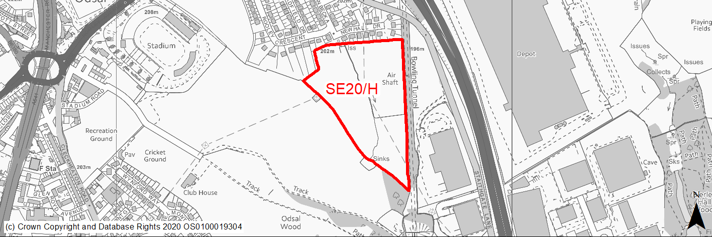
Site location
Regional City - Bradford SE
Ward
Wyke
Site description
Greenfield site.
Proposed Allocation
Housing
SHLAA referencce
SE/069
Indicative no. dwellings
145
Site area (Gross) (ha)
5.94
Ownership
Private
Delivery timescales
Developable (6-10 years)
Type (PDL/Greenfield)
Greenfield
Green Belt
No
Flood Zone
Flood Zone 1
Potential site access
Access can be gained from the existing highway network, subject to widening which may require 3rd party land.
Public Transport Accessibility
Bus Stop within 400m of Service 508 frequent service.
Sustainability Appraisal
The site is located 330m south of the CAZ, and due to the number of dwellings proposed, this development could potentially make achieving air quality improvement targets within the CAZ more difficult. A significant adverse effect has therefore been predicted for the air quality SA Objective.
Minor positive effects were predicted for a range of socio-economic themed SA Objectives due to the benefits of new residential development for the local economy as well as the location of the site in relation to health facilities and employment areas. However, the site’s access to transport links, services and amenities, and educational facilities is somewhat limited, with residents being required to travel outside the target distances.
Additional minor adverse effects were predicted for a range of natural environment themed SA Objectives, primarily as a result of the impacts of new development on a 100% greenfield site adjoining Ancient Woodland. There is a small waterbody running through the site, to which careful consideration would be required so as to protect the water quality as well as to limit the risk of surface water flooding.
Habitats Regulations Assessment
This site is beyond the zones of influence of the South Pennine Moors SPA/SAC and is therefore unlikely to have any significant effects, a HRA is not required.
Green Belt
N/A – Site not within the Green Belt.
Constraints and Opportunities
• The site forms part of a wider green corridor.
• The site borders a landfill location and a significant proportion of the site is within a landfill buffer for which further investigations may be required.
• Surface water flood risk across central part of the site.
• Part of the site is likely to be required for access and road infrastructure to service the proposed park and ride facility immediately to the west of the site.
• Extreme southern edge of the site falls within Major Hazard Outer Zone.
• Site borders Bradford Golf course to the west which is classified as natural and semi-natural greenspace as well as the wider grassland habitat network.
• Odsal Wood which is ancient woodland borders the site to the extreme south.
• Northern and southern edges of the site within high risk former mining activities area with further investigation required.
Development considerations
• The design should incorporate Green infrastructure to aid the connectivity of the site with neighbouring woodland and the watercourse.
• Hedgerows and the water course should be retained and enhanced within public areas.
• Environmental buffer to ancient woodland is likely to be required.
• Scheme will need to be designed in consideration of wider infrastructure and access requirements for the proposed park and ride facility.
Conclusion/Summary
Greenfield site which makes a contribution to the wider greenspace in the area and facilitate the free movement of wildlife. The site should be design to retain trees and hedgerows with enhancements of the waterway and additional planting to the east and south. Site should be designed in light of proximity to proposed park and ride facility and has capacity to accommodate approximately 145 homes.
(1) SE21/H - New Lane, Laisterdyke
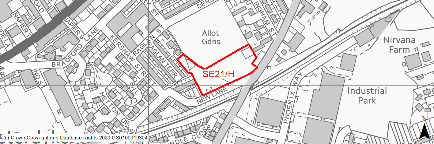
Site location
Regional City - Bradford SE
Ward
Bradford Moor
Site description
Green field site. Former allotments.
Proposed Allocation
Housing
SHLAA referencce
SE/076
Indicative no. dwellings
28
Site area (Gross) (ha)
0.77
Ownership
Council
Delivery timescales
Developable (6-10 years)
Type (PDL/Greenfield)
Greenfield
Green Belt
No
Flood Zone
Flood Zone 1
Potential site access
No access issues.
Public Transport Accessibility
Bus Stop within 400m with a frequent service.
Sustainability Appraisal
No significant adverse effects predicted for the site. Minor adverse effects predicted for most natural environment themed SA Objectives, primarily as a result of the effects associated with development on greenfield. The site is well located to provide residents here with good access to buses, jobs, health facilities, and cultural spaces, with particularly good access to schools. Residents may need to travel up to 1km to access some services, such as shops.
Habitats Regulations Assessment
This site is beyond the zones of influence of the South Pennine Moors SPA/SAC and is therefore unlikely to have any significant effects, a HRA is not required.
Green Belt
N/A – Site not within the Green Belt.
Constraints and Opportunities
• The site sits higher than the road which may impact on access.
• Public right of way will need to be retained/rerouted.
• Form part of the wider green infrastructure network.
• Site forms part of the improved grassland / scrub habitat network.
• Falls within landfill buffer which may require further investigation.
• Visible frontage location.
Development considerations
• The design of the site should incorporate new trees along the site frontage.
• Design and layout of the scheme will need to take into consideration the role of the site within the wider green infrastructure and habitat networks.
Conclusion/Summary
Underused greenfield site with access from New Lane. Trees on the western edge should be retained and additional tree planting provided on the northern edge. The site could be developed for at least 28 dwellings with an integrated green infrastructure strategy and provide for a strengthened street form.
(3) SE22/H - Furnace Road, Oakenshaw
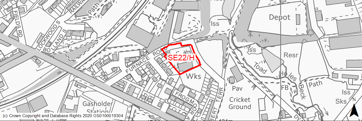
Site location
Regional City - Bradford SE
Ward
Wyke
Site description
Site currently partly used for Industrial shed and outdoor storage. Site has had residential planning permission previously.
Proposed Allocation
Housing
SHLAA referencce
SE/079
Indicative no. dwellings
14
Site area (Gross) (ha)
0.45
Ownership
Private
Delivery timescales
Developable (6-10 years)
Type (PDL/Greenfield)
PDL
Green Belt
No
Flood Zone
Flood Zone 1
Potential site access
Access from Furnace Road which is unadopted in part. The road will need to be made up into the site.
Public Transport Accessibility
Bus Stop within 400m with a frequent service.
Sustainability Appraisal
Major adverse effects due to proximity of the site to major hazards (middle and outer zones). Minor adverse effects predicted for the water resources and air quality SA Objectives, as predicted for most sites. Minor adverse effects due to proximity (within 50 metre) of listed building. The site would be a good opportunity to deliver biodiversity net gains and improvements to the local character, given its current condition and use. The site is well located to provide residents with good access to shops, jobs, cultural spaces, and health facilities, with particularly good access to public transport options. The site is just outside the desired range for schools.
Habitats Regulations Assessment
This site is beyond the zones of influence of the South Pennine Moors SPA/SAC and is therefore unlikely to have any significant effects, a HRA is not required.
Green Belt
N/A – Site not within the Green Belt.
Constraints and Opportunities
• Site lies within the defined hazardous installation zones and as such the number of homes will be limited to the guidelines of the HSE.
• Forms part of a wider green infrastructure corridor.
• The site has previously had outline permission with principle of development previously accepted.
• South east quarter of the site within high risk former mining activities area with further investigation required.
Development considerations
• Site should retain and enhance on site trees particularly along Furnace Road.
• Development of the site can be delivered independently but could also be part of a comprehensive scheme involving SE14/H, subject to development limits.
Conclusion/Summary
Brownfield site in a sustainable area which provides an opportunity to regenerate this part of Oakenshaw. Site has had outline permission previously and a new application will require access into the site to be made up to an adoptable standard. Potential development yield will be limited by the location of the site.
(2) SE23/HC - Tennis Avenue
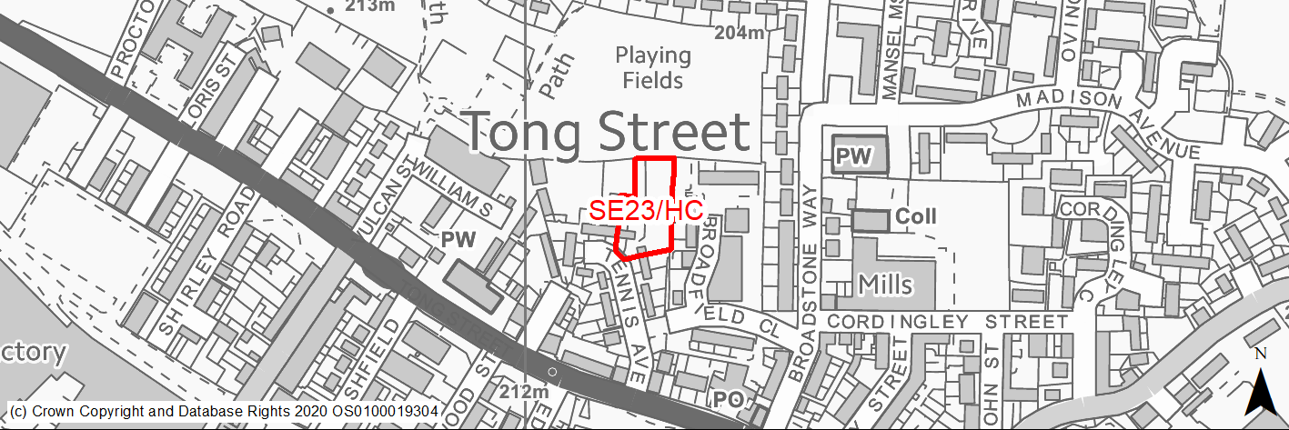
Site location
Regional City - Bradford SE
Ward
Tong
Site description
Level cleared, vacant site with outline planning permission for 11 homes. Although previously developed the site has now become green given the time which has elapsed since it was cleared.
Proposed Allocation
Housing
SHLAA referencce
SE/089
Indicative no. dwellings
11
Site area (Gross) (ha)
0.27
Ownership
Private
Delivery timescales
Deliverable (0-5 years)
Type (PDL/Greenfield)
Greenfield
Green Belt
No
Flood Zone
Flood Zone 1
Potential site access
No access issues.
Public Transport Accessibility
Bus Stop within 400m with a frequent service.
Sustainability Appraisal
Significant positive effects predicted for SA Objectives related to social cohesion, health, and education due to the accessibility of health and school facilities as well as the positive effect new development could have here on an area of high deprivation.
Minor positive effects predicted for most other socio-economic themed SA Objectives due to the location of the site in relation to key services, jobs, and amenities.
No significant adverse effects predicted for any SA Objective. Minor adverse effects predicted for most natural environment themed SA Objectives, primarily as a result of the effects associated with new development on greenfield.
Habitats Regulations Assessment
This site is beyond the zones of influence of the South Pennine Moors SPA/SAC and is therefore unlikely to have any significant effects, a HRA is not required.
Green Belt
N/A – Site not within the Green Belt.
Constraints and Opportunities
• Trees should be provided to the northern edge.
• Part of natural and semi-natural greenspace network.
• Forms part of wider green infrastructure network.
• PROW along eastern boundary of the site.
Development considerations
• The site adjoins a further significant area of open space and the detailed design should incorporate landscaping along the northern edge and green infrastructure considerations through the scheme.
Conclusion/Summary
Site in a sustainable location and with outline permission for 11 homes. Historically developed but now green in appearance. The redevelopment of the site provides an opportunity to improve this residential area, integrate green spaces and stop unauthorised access and tipping.
(2) SE24/HC - Upper Castle Street
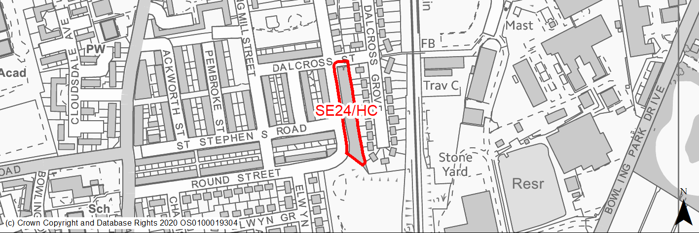
Site location
Regional City - Bradford SE
Ward
Little Horton
Site description
Vacant narrow grassed site with some local amenity value.
Proposed Allocation
Housing
SHLAA referencce
SE/092
Indicative no. dwellings
9
Site area (Gross) (ha)
0.24
Ownership
Private
Delivery timescales
Deliverable (0-5 years)
Type (PDL/Greenfield)
Greenfield
Green Belt
No
Flood Zone
Flood Zone 1
Potential site access
No access issues.
Public Transport Accessibility
Site is over 600m from a bus stop with a frequent service.
Sustainability Appraisal
The site could deliver major positive effects for residents on both the health and education SA Objectives as a result of being within the target distances for all necessary health facilities and centres for primary and secondary education.
A significant adverse effect has been predicted for the air quality SA Objective as a result of the site being situated entirely within the CAZ. Development here could potentially make achieving air quality improvement targets within the CAZ more difficult.
Minor positive effects were predicted for nearly all other socio-economic themed SA Objectives due to the benefits of new residential development for the local economy as well as the location of the site in relation to transport links, local services and amenities, and employment areas.
As a greenfield site containing TPO woodland which would be lost, the development has been predicted to result in minor adverse effects on most natural environment themed SA Objectives for this site.
Habitats Regulations Assessment
This site is beyond the zones of influence of the South Pennine Moors SPA/SAC and is therefore unlikely to have any significant effects, a HRA is not required.
Green Belt
N/A – Site not within the Green Belt.
Constraints and Opportunities
• The development of the site will reduce opportunities for tipping.
• Part of the site within a landfill buffer for which further investigation may be required.
• Extreme eastern edge of the site within Major Hazard Outer Zone.
• Potential risk of surface water flooding along western edge and across parts of the site.
Development considerations
• Trees should be retained within the development and new trees provided as part of a defined area which could be retained as open space.
• Further analysis required on the extent of surface water flood risk and appropriate mitigation measures.
Conclusion/Summary
Linear greenfield site which offers the opportunity for additional new development of a modest scale.
(1) SE25/H - Grayswood Drive, Holme Wood
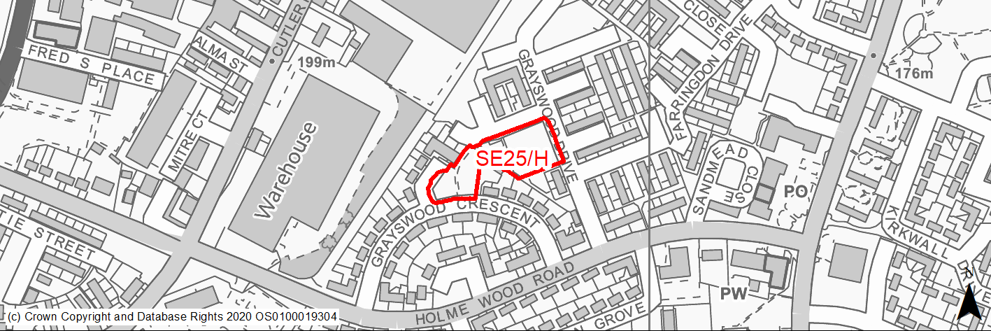
Site location
Regional City - Bradford SE
Ward
Tong
Site description
Cleared land now greened and use for incidental open space between residential properties.
Proposed Allocation
Housing
SHLAA referencce
SE/102
Indicative no. dwellings
13
Site area (Gross) (ha)
0.41
Ownership
Private
Delivery timescales
Developable (6-10 years)
Type (PDL/Greenfield)
Greenfield
Green Belt
No
Flood Zone
Flood Zone 1
Potential site access
No access issues.
Public Transport Accessibility
Bus Stop within 400m with a frequent service.
Sustainability Appraisal
The site could deliver major positive effects for residents on both the health and education SA Objectives as a result of being within the target distances for all necessary health facilities and centres for primary and secondary education.
Minor positive effects were predicted for most other socio-economic themed SA Objectives due to the benefits of new residential development for the local economy as well as the location of the site in relation to transport links and employment areas.
No major adverse effects have been predicted for the site, but minor adverse effects were predicted for a range of natural environment themed SA Objectives, primarily as a result of the impacts of new development on a 100% greenfield site.
Habitats Regulations Assessment
This site is beyond the zones of influence of the South Pennine Moors SPA/SAC and is therefore unlikely to have any significant effects, a HRA is not required.
Green Belt
N/A – Site not within the Green Belt.
Constraints and Opportunities
• Existing rights of way should be retained or resited where possible.
• Forms part of a wider green infrastructure network.
• Previously developed site.
• North eastern section of the site within a landfill buffer which may require further investigation.
• Majority of the site within high risk former mining activities area with further investigation required.
Development considerations
• New street trees should be provided as appropriate.
• Layout should consider relationship with existing dwellings and development of defensible space and clear differentiation between public and private space.
• May be opportunities to retain a degree of open space / green infrastructure to maintain network connections.
Conclusion/Summary
The land which has been developed previously, is now being maintained as open space. The development of the land could provide an opportunity for around 13 new homes.
(1) SE26/HC - Shetcliffe Lane
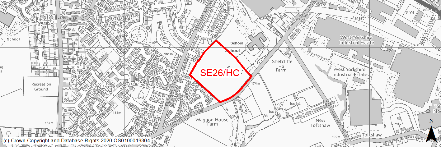
Site location
Regional City - Bradford SE
Ward
Tong
Site description
Slightly sloping field with outline permission in place for 106 homes.
Proposed Allocation
Housing
SHLAA referencce
SE/109
Indicative no. dwellings
106
Site area (Gross) (ha)
3.47
Ownership
Council
Delivery timescales
Deliverable (0-5 years)
Type (PDL/Greenfield)
Greenfield
Green Belt
No
Flood Zone
Flood Zone 1
Potential site access
No access issues.
Public Transport Accessibility
Bus Stop within 400m with a frequent service.
Sustainability Appraisal
The site could deliver a major positive effect for residents on the health SA Objective as a result of being within the target distances for all necessary health facilities.
Minor positive effects were predicted for most other socio-economic themed SA Objectives due to the benefits of new residential development for the local economy as well as the location of the site in relation to transport links, education facilities and employment areas.
No major adverse effects have been predicted for the site, but minor adverse effects were predicted for a range of natural environment themed SA Objectives, primarily as a result of the impacts of new development on a 100% greenfield site containing trees. The site is 100m north of High Royds Beck, and development here could pose a risk to the water quality.
Habitats Regulations Assessment
This site is beyond the zones of influence of the South Pennine Moors SPA/SAC and is therefore unlikely to have any significant effects, a HRA is not required.
Green Belt
N/A – Site not within the Green Belt.
Constraints and Opportunities
• There is an area of surface water flood risk across the central part of the site which runs north/south.
• Site falls within a landfill buffer, which may require further investigations to be undertaken.
• School playing fields to the north east of the site and within close proximity to local school.
• Prime frontage site.
• Small southern area of the site within high risk former mining activities area with further investigation required.
Development considerations
• Mature trees along the western, and north site boundaries should be retained as well as the small woodland in the south east.
• Mitigation of surface water flooding across the central part of the site will be required.
Conclusion/Summary
Greenfield site with outline planning permission for 106 homes. There are no significant development constraints to prevent the site coming forward.
(2) SE27/HC - Mead View, Holme Wood
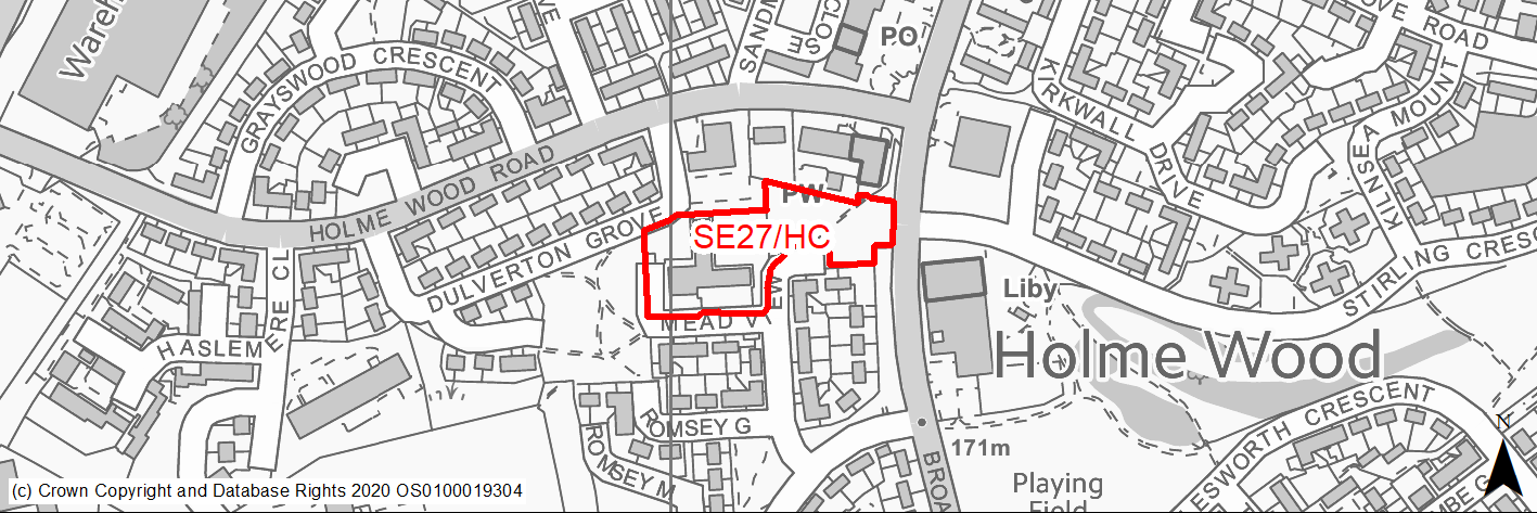
Site location
Regional City - Bradford SE
Ward
Tong
Site description
Former care home site and informal greenspace.
Proposed Allocation
Housing
SHLAA referencce
SE/111 and SE/181
Indicative no. dwellings
41
Site area (Gross) (ha)
0.68
Ownership
Private
Delivery timescales
Developable (6-10 years)
Type (PDL/Greenfield)
Mixed
Green Belt
No
Flood Zone
Flood Zone 1
Potential site access
No access issues.
Public Transport Accessibility
Bus Stop within 400m with a frequent service.
Sustainability Appraisal
The site could deliver major positive effects for residents on both the health and education SA Objectives as a result of being within the target distances for all necessary health facilities and centres for primary and secondary education.
Minor positive effects were predicted for most other socio-economic themed SA Objectives due to the benefits of new residential development for the local economy as well as the location of the site in relation to transport links and employment areas.
No major adverse effects have been predicted. The site is partially greenfield, so is likely to be of some biodiversity and visual value in its current condition, and therefore minor adverse effects were predicted for a range of natural environment themed SA Objectives.
Habitats Regulations Assessment
This site is beyond the zones of influence of the South Pennine Moors SPA/SAC and is therefore unlikely to have any significant effects, a HRA is not required.
Green Belt
N/A – Site not within the Green Belt.
Constraints and Opportunities
• Area of surface water flood risk along the northern boundary, this is not expected to impact negatively on the potential yield.
• Part of wider green infrastructure corridor.
• PROW on far eastern edge of the site.
• Site has outline permission.
Development considerations
• Tree planting will be required.
• Layout should consider relationship with existing dwellings and development of defensible space and clear differentiation between public and private space.
• May be opportunities to retain a degree of open space / green infrastructure to maintain network connections.
Conclusion/Summary
Site formed from two areas - one greenfield and one brownfield (former care home). The site has no access issues and could be redeveloped to accommodate around 41 homes using existing local access roads. The development of the site is likely to have a positive impact on the local area and may benefit from detailed design and masterplanning to raise housing quality in the area.
(1) SE28/H - Somerton Drive, Holme Wood
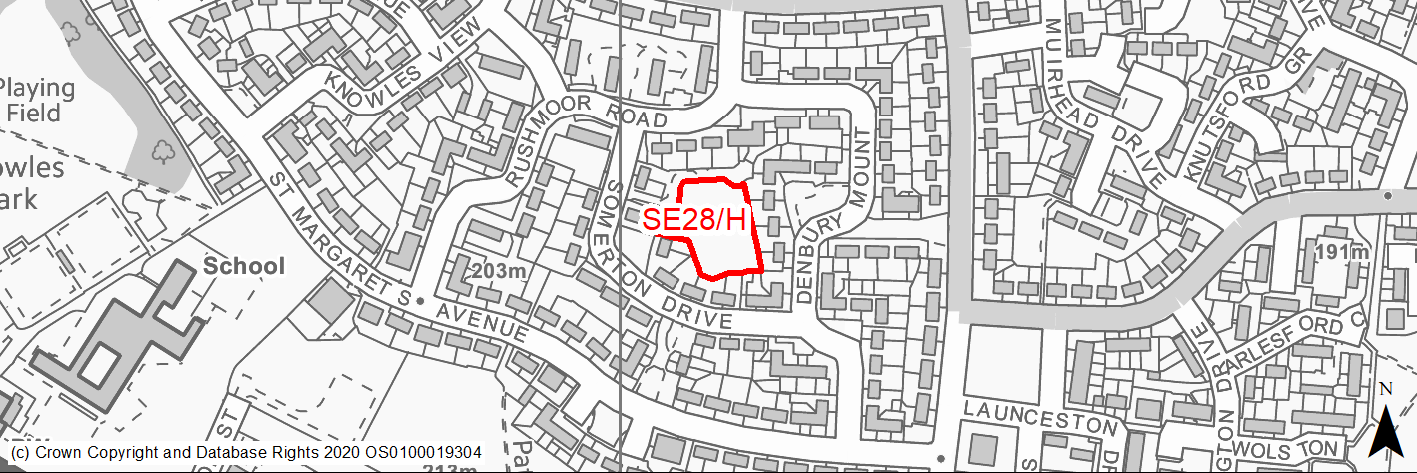
Site location
Regional City - Bradford SE
Ward
Tong
Site description
Cleared site which has been greened and is now informal open space.
Proposed Allocation
Housing
SHLAA referencce
SE/114
Indicative no. dwellings
5
Site area (Gross) (ha)
0.27
Ownership
Council
Delivery timescales
Developable (6-10 years)
Type (PDL/Greenfield)
Greenfield
Green Belt
No
Flood Zone
Flood Zone 1
Potential site access
Narrow access from Somerton Drive will limit the number of homes unless it can be widened.
Public Transport Accessibility
Bus Stop within 400m with a frequent service.
Sustainability Appraisal
The site could deliver major positive effects for residents on both the health and education SA Objectives as a result of being within the target distances for all necessary health facilities and centres for primary and secondary education.
Minor positive effects were predicted for nearly all other socio-economic themed SA Objectives due to the benefits of new residential development for the local economy as well as the location of the site in relation to transport links, local services and amenities, and employment areas.
No major adverse effects have been predicted for the site, but minor adverse effects were predicted for a range of natural environment themed SA Objectives, primarily as a result of the impacts of new development on a 100% greenfield site.
Habitats Regulations Assessment
This site is beyond the zones of influence of the South Pennine Moors SPA/SAC and is therefore unlikely to have any significant effects, a HRA is not required.
Green Belt
N/A – Site not within the Green Belt.
Constraints and Opportunities
• Access may need to be widened.
• Current use as open space.
• Site is enclosed by housing and has limited vehicle access which limits site yield.
• Approximately a third of the northern section of the site within high risk former mining activities area with further investigation required.
Development considerations
• Off street car parking for existing residents should be accommodated within overall scheme design.
• Need for a sensitive design given size of the site and proximity to existing housing.
Conclusion/Summary
Greenfield site which could be developed for at least 5 homes. The development of the site provides the opportunity for new affordable homes and improve road access to other properties and prevents anti social behaviour including tipping.
(2) SE29/H - Kaycell Street, Bierley
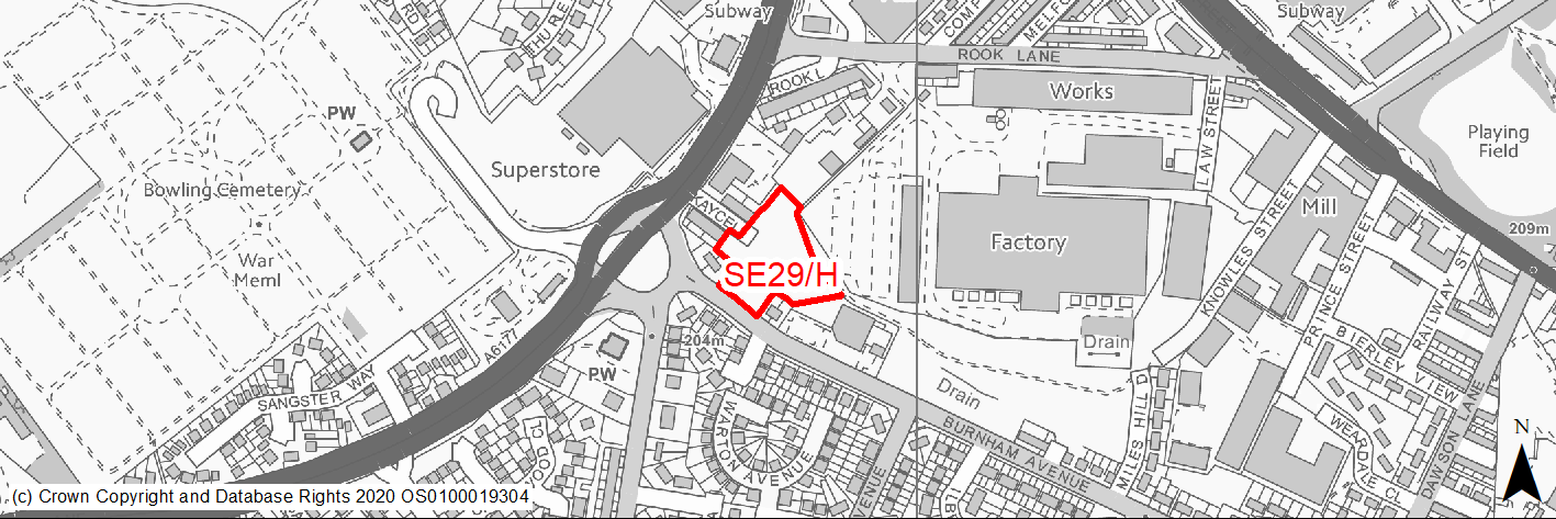
Site location
Regional City - Bradford SE
Ward
Tong
Site description
2 Greenfield sites which have been merged to form single site with new boundary. The land is level.
Proposed Allocation
Housing
SHLAA referencce
SE/118 and SE/169
Indicative no. dwellings
23
Site area (Gross) (ha)
0.62
Ownership
Private
Delivery timescales
Developable (6-10 years)
Type (PDL/Greenfield)
Greenfield
Green Belt
No
Flood Zone
Flood Zone 1
Potential site access
No direct access to the adopted highways network.
Public Transport Accessibility
Bus Stop within 400m with a frequent service.
Sustainability Appraisal
No significant adverse effects predicted for the site. Minor adverse effects predicted for water resources and air quality SA Objectives, as predicted for most sites. The site would be a good opportunity to deliver biodiversity net gains and improvements to the local character, given its current condition. The site is well located to provide residents with good access to shops, jobs, buses, and cultural spaces, with particularly good access to schools and health facilities.
Habitats Regulations Assessment
This site is beyond the zones of influence of the South Pennine Moors SPA/SAC and is therefore unlikely to have any significant effects, a HRA is not required.
Green Belt
N/A – Site not within the Green Belt.
Constraints and Opportunities
• Potential noise from neighbouring business to the north.
• PROW on eastern edge of the site.
• Possible small cluster of surface water flood risk within south eastern corner of the site.
• All of the site within high risk former mining activities area with further investigation required.
Development considerations
• New tree planting and landscape buffer should be provided to mitigate any noise associated with industrial use.
• PROW routes should be maintained or alternatives built into the scheme design.
Conclusion/Summary
Greenfield site in sustainable location created by combining two sites. Access should be taken from Burnham Avenue.
(4) SE30/H - Bierley Lane, Bierley
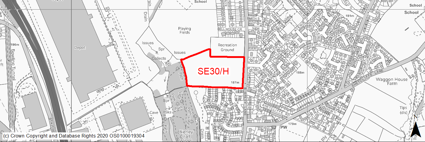
Site location
Regional City - Bradford SE
Ward
Tong
Site description
Slightly sloping greenfield site fronting road.
Proposed Allocation
Housing
SHLAA referencce
SE/128
Indicative no. dwellings
88
Site area (Gross) (ha)
3.34
Ownership
Council
Delivery timescales
Developable (6-10 years)
Type (PDL/Greenfield)
Greenfield
Green Belt
No
Flood Zone
Flood Zone 1
Potential site access
No access issues.
Public Transport Accessibility
Bus Stop within 400m with a frequent service.
Sustainability Appraisal
No significant adverse effects predicted for the site. Minor adverse effects predicted for most natural environment themed SA Objectives, primarily as a result of the effects associated with development on greenfield. The site is well located to provide residents here with good access to cultural spaces, jobs, buses, and schools, with particularly good access to health facilities. Residents may need to travel up to 1km to access some shops.
Habitats Regulations Assessment
This site is beyond the zones of influence of the South Pennine Moors SPA/SAC and is therefore unlikely to have any significant effects, a HRA is not required.
Green Belt
N/A – Site not within the Green Belt.
Constraints and Opportunities
• Site adjoins Bierley Woods (defined as LWS, natural and semi-natural greenspace and woodland habitat), potential impact .
• Public footpath crosses the site from adjacent football pitch / recreation ground into woodland.
• Western part of the site falls within wider green infrastructure corridor.
• Prime frontage site.
• Relatively small north east section of the site within high risk mining area.
Development considerations
• Significant open space/landscaping will need to be provided on the western side of the site. This should be designed around the public footpath and include additional trees to link with the wooded area.
• Scheme design expected to effectively address and strengthen street frontage.
Conclusion/Summary
Mitigation required within the west and north eastern sections of the site to minimise impact on nearby ecological assets and reduce risk around former mining area. Development yield is reflective of site constraints.
(1516) SE31/H - Land west of Ned Lane, Holme Wood
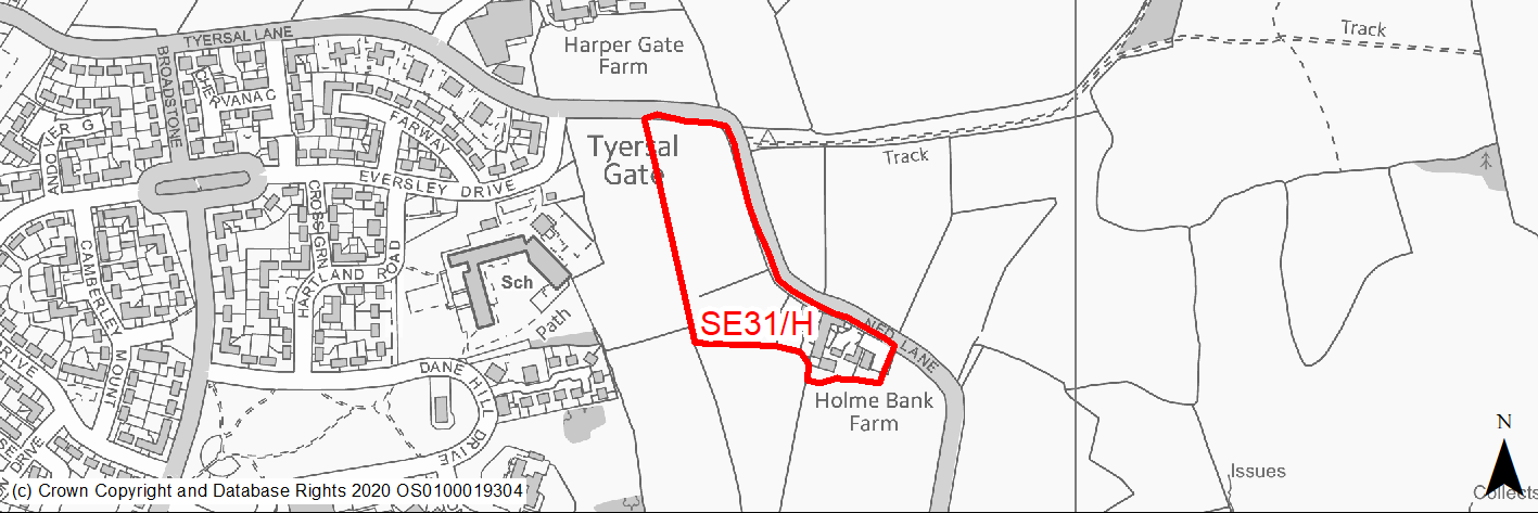
Site location
Regional City - Bradford SE
Ward
Tong
Site description
Fields in Agricultural use with moderate slope north to south and listed farm buildings.
Proposed Allocation
Housing
SHLAA referencce
SE/137
Indicative no. dwellings
53
Site area (Gross) (ha)
2.04
Ownership
Council/Private
Delivery timescales
Developable (6-10 years)
Type (PDL/Greenfield)
Greenfield
Green Belt
Yes
Flood Zone
Flood Zone 1
Potential site access
Access from Ned Lane which will require improvement and widening.
Public Transport Accessibility
Site is just over 400m from frequent bus service.
Sustainability Appraisal
See individual Sustainability Appraisal site comment in the accompanying report.
Habitats Regulations Assessment
This site is beyond the zones of influence of the South Pennine Moors SPA/SAC and is therefore unlikely to have any significant effects, a HRA is not required.
Green Belt
See individual Green Belt site assessment in the accompanying report.
Constraints and Opportunities
• The site should only be developed comprehensively with neighbouring sites SE13/H and SE18/H, together with site SE45/H and informed by a detailed masterplan. The settings of listed buildings within the south east of the site are particularly sensitive and will require careful consideration, including heritage impact assessments.
• Site forms part of wider green infrastructure corridor considerations.
• Significant proportion of the top of the site is within coal mining activities high risk area, together with the south east edge of the site.
Development considerations
• Road widening will require the approval of the Council as landowner.
• Heritage impact assessments required.
• Further investigative works required in relation to coal mining risks and activities.
• A buffer/area of open space will be required to mitigate the impact of the development on the listed buildings with new tree planting along Ned Lane.
• Comprehensive masterplan required in conjunction with neighbouring sites and in consideration of maintaining a strong Green Belt edge to the settlement, heritage impact considerations, road infrastructure constraints and changes in elevation through the site, together with wider green and community infrastructure connections.
Conclusion/Summary
Green belt site on the edge of the urban area contained by Ned Lane. The site should be developed comprehensively led by a masterplan with neighbouring sites to provide appropriately sensitive design, infrastructure, open space and landscaping.
(1516) SE45/H - Holme Lane/Raikes Lane
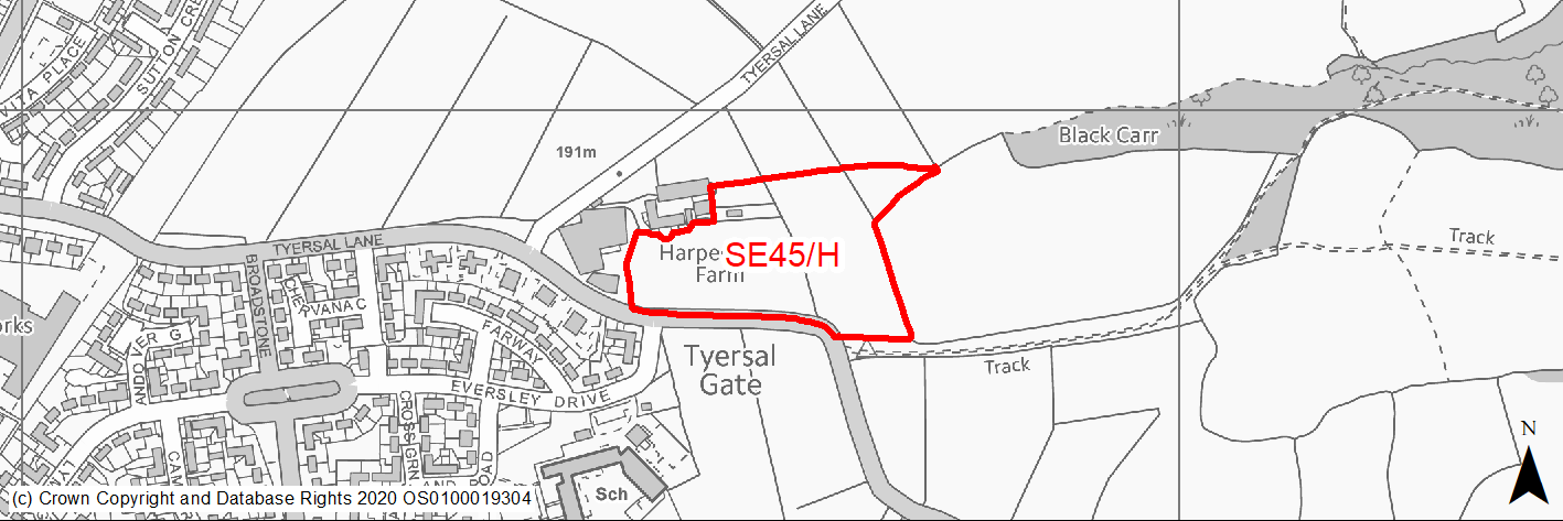
Site location
Regional City - Bradford SE
Ward
Tong
Site description
Greenfield site in agricultural use.
Proposed Allocation
Housing
SHLAA referencce
SE/060
Indicative no. dwellings
68
Site area (Gross) (ha)
2.6
Ownership
Private
Delivery timescales
Developable (6-10 years)
Type (PDL/Greenfield)
Greenfield
Green Belt
Yes
Flood Zone
Flood Zone 1
Potential site access
No access issues, but road widening of Ned Lane will be required
Public Transport Accessibility
Site is within 400m of a bus stop on a high frequency service.
Sustainability Appraisal
See individual Sustainability Appraisal site comment in the accompanying report.
Habitats Regulations Assessment
This site is beyond the zones of influence of the South Pennine Moors SPA/SAC and is therefore unlikely to have any significant effects, a HRA is not required.
Green Belt
See individual Green Belt site assessment in the accompanying report.
Constraints and Opportunities
• Site lies close to Black Carr woods an ancient woodland and Local Wildlife Site.
• Bridleway immediately outside the south eastern edge of the site.
• Green Belt edge of the site will need to be strengthened to the east to avoid any future breaching and also due to proximity to ancient woodland.
• The site should only be developed comprehensively with nearby sites SE13/H, SE18/H and SE31/H and informed by a detailed masterplan.
Development considerations
• The eastern side of the site will need to be sensitively developed with a substantial landscape buffer with tree and shrub planting to form a strong urban edge and to avoid breaching further into the countryside / Green Belt.
• Comprehensive masterplan required in conjunction with nearby sites and in consideration of maintaining a strong Green Belt edge to the settlement, road infrastructure constraints together with wider green and community infrastructure connections.
Conclusion/Summary
The site is greenfield (green belt) in a sustainable location, with good access to local amenities and public transport. The site should be developed comprehensively led by a masterplan alongside sites to the south of Ned Lane SE31/H, SE18/H and SE13/H.
(1523) SE46/H - Land west of Tong Lane and east of Holme Wood
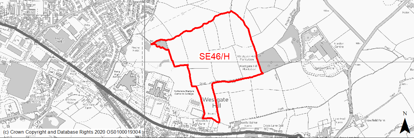
Site location
Regional City - Bradford SE
Ward
Tong
Site description
Undulating fields separated by patchy hedgerows and some trees. The land is currently in agricultural use. Site forms part of a larger proposed Tong Street / Westgate Hill Street masterplan and growth area.
Proposed Allocation
Housing
SHLAA referencce
SE/100
Indicative no. dwellings
582
Site area (Gross) (ha)
22.18
Ownership
Private
Delivery timescales
Developable (11-15 years)
Type (PDL/Greenfield)
Greenfield
Green Belt
Yes
Flood Zone
Flood Zone 1
Potential site access
No direct site access. Existing roads and lane infrastructure in the area are only suitable for low number of dwellings and not capable of accommodating traffic generated by a strategic scale development. Access for large sites such as this and neighbouring site SE47/H will require major highway improvements. Site will need to come forward with a comprehensive transport assessment and mitigation strategy and as part of wider masterplanning.
Public Transport Accessibility
Site is just over 400m from frequent bus service. A fully integrated public transport strategy with early delivery will be required for a development of this scale.
Sustainability Appraisal
See individual Sustainability Appraisal site comment in the accompanying report.
Habitats Regulations Assessment
This site is beyond the zones of influence of the South Pennine Moors SPA/SAC and is therefore unlikely to have any significant effects, a HRA is not required.
Green Belt
See individual Green Belt site assessment in the accompanying report.
Constraints and Opportunities
• Surface water flood risk potential to the northern edge of the site.
• PROW runs within the site connecting edge of Holme Wood estate to Westgate Hill Street.
• Southern sections of the site are part of wider green infrastructure corridor.
• Major Hazard Gas Pipeline runs through the extreme southern finger of the site and a further gas pipeline runs along the western edge of the site.
• Significant proportion of the northern section of the site within high risk former mining activities area with further investigation required.
• Part of the eastern edge of the site falls within a landfill buffer and further investigations may be required.
• Kit Wood and surrounds provide a strong ecological and landscape feature to the east of the site and potentially a strong Green Belt edge.
• The change in elevations further north of the site plus watercourse infrastructure may help provide a clearly defined settlement and Green Belt edge.
• The majority of the site is positioned on a relatively level plateau.
• No direct vehicle access and site will need to come forward in conjunction with SE19/H, SE47/H, SE48/H and SE37/E.
• Technical studies are currently progressing on options and feasibility for the development of the South East Bradford Access Road (SEBAR), which if progressed may be within close proximity to this site.
Development considerations
• The site will need to come forward as part of a comprehensive and detailed masterplan for the area in conjunction with sites SE19/H, SE47/H, SE48/H and SE37/E.
• The masterplan will need to address as a minimum:
- Site evidence and baseline material, including local context, character and technical studies including topography and ground conditions.
- An overall vision and sense of place, including wider spatial context.
- Green belt context, ecological assets, landscape and heritage.
- Open space and green infrastructure layers.
- Housing portfolio, mix and affordable units.
- Connectivity and movement – access, traffic and movement and inclusive design, PROW, healthy places and streets, active travel routes and parking.
- Design quality – approach to density, built form, massing, plots, local precedents, style, building coherence, variety, uniformity, roofs, key buildings and corners.
- Place function and infrastructure – waste management, hard and soft infrastructure, community infrastructure, water management and drainage.
- Delivery, phasing and viability
• Masterplan may form part of a wider corridor development strategy for the South East Bradford Access Road, subject to ongoing technical studies and evidence.
Conclusion/Summary
Site forms part of the proposed Tong Street / Westgate Hill Street masterplan area and will need to come forward as part of a comprehensive development in line with the masterplan considerations set out under development considerations. Estimated site yield is circa 582 dwellings, but will be subject to further analysis as part of the masterplan development.
(1522) SE47/H - Westgate Hill Street, Tong Lane, Holme Wood
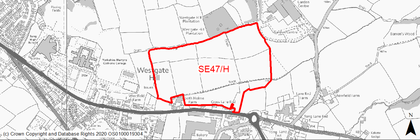
Site location
Regional City - Bradford SE
Ward
Tong
Site description
Undulating fields, which slope gently towards the north and east. Site forms part of a larger proposed Tong Street / Westgate Hill Street masterplan and growth area.
Proposed Allocation
Housing
SHLAA referencce
SE/099
Indicative no. dwellings
542
Site area (Gross) (ha)
20.66
Ownership
Council/Private
Delivery timescales
Developable (6-10 years)
Type (PDL/Greenfield)
Greenfield
Green Belt
Yes
Flood Zone
Flood Zone 1
Potential site access
Only current direct access is off Tong Lane. A new appropriate standard access would need to be provided with 200 dwellings from one access point.
Public Transport Accessibility
Much of the site lies within 400m of a bus stop but this is not a frequent bus service.
Sustainability Appraisal
See individual Sustainability Appraisal site comment in the accompanying report.
Habitats Regulations Assessment
This site is beyond the zones of influence of the South Pennine Moors SPA/SAC and is therefore unlikely to have any significant effects, a HRA is not required.
Green Belt
See individual Green Belt site assessment in the accompanying report.
Constraints and Opportunities
• Major Hazard Gas Pipeline runs through the centre of the site.
• Forms part of a wider green infrastructure corridor.
• Semi-improved neutral grassland habitat forms a major element of the site.
• Eastern edge of the site is within a landfill buffer and borders a landfill site which may require further investigation.
• Small pockets of high risk former mining areas within site boundary.
• Kit Wood and surrounds (including garden centre) provide a strong ecological and landscape feature to the north east of the site and potentially a strong Green Belt edge.
• Potential to maintain a green infrastructure / ecological corridor through centre of the site and structure built form away from hazard areas to concentrate on higher densities towards Westgate Hill Street frontage.
Development considerations
• The site will need to come forward as part of a comprehensive and detailed masterplan for the area in conjunction with sites SE19/H, SE46/H, SE48/H and SE37/E.
• The masterplan will need to address as a minimum:
- Site evidence and baseline material, including local context, character and technical studies including topography and ground conditions.
- An overall vision and sense of place, including wider spatial context.
- Green belt context, ecological assets, landscape and heritage.
- Open space and green infrastructure layers.
- Housing portfolio, mix and affordable units.
- Connectivity and movement – access, traffic and movement, and inclusive design, PROW, healthy places and streets, active travel routes and parking.
- Design quality – approach to density, built form, massing, plots, local precedents, style, building coherence, variety, uniformity, roofs, key buildings and corners.
- Place function and infrastructure – waste management, hard and soft infrastructure, community infrastructure, water management and drainage.
- Delivery, phasing and viability
• Masterplan may form part of a wider corridor development strategy for the South East Bradford Access Road, subject to ongoing technical studies and evidence.
Conclusion/Summary
Site forms part of the proposed Tong Street / Westgate Hill Street masterplan area and will need to come forward as part of a comprehensive development in line with the masterplan considerations set out under development considerations. Estimated site yield is circa 542 dwellings, but will be subject to further analysis as part of the masterplan development.
(1517) SE48/H - Westgate Hill Street, Tong
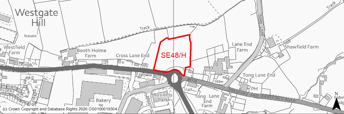
Site location
Regional City - Bradford SE
Ward
Tong
Site description
Greenfield site in agricultural use.
Proposed Allocation
Housing
SHLAA referencce
SE/057
Indicative no. dwellings
27
Site area (Gross) (ha)
1.7
Ownership
Council
Delivery timescales
Developable (6-10 years)
Type (PDL/Greenfield)
Greenfield
Green Belt
Yes
Flood Zone
Flood Zone 1
Potential site access
No access issues.
Public Transport Accessibility
Bus stop within 400m but this isn't currently a high frequency service.
Sustainability Appraisal
See individual Sustainability Appraisal site comment in the accompanying report.
Habitats Regulations Assessment
This site is beyond the zones of influence of the South Pennine Moors SPA/SAC and is therefore unlikely to have any significant effects, a HRA is not required.
Green Belt
See individual Green Belt site assessment in the accompanying report.
Constraints and Opportunities
• Woodland to the west is protected.
• Small area of high risk former coal mining activities to the extreme south western edge of the site.
• South Eastern edge of the site is within Historic Battlefield buffer - development options in this area will need to consider in detail wider heritage implications.
• New tree planting should be provided to create a gateway feature for the adjacent larger development sites.
Development considerations
• The site will need to come forward as part of a comprehensive and detailed masterplan for the area in conjunction with sites SE19/H, SE46/H, SE47/H and SE37/E.
• The masterplan will need to address as a minimum:
- Site evidence and baseline material, including local context, character and technical studies including topography and ground conditions.
- An overall vision and sense of place, including wider spatial context.
- Green belt context, ecological assets, landscape and heritage.
- Open space and green infrastructure layers.
- Housing portfolio, mix and affordable units.
- Connectivity and movement – access, traffic and movement and inclusive design, PROW, healthy places and streets, active travel routes and parking.
- Design quality – approach to density, built form, massing, plots, local precedents, style, building coherence, variety, uniformity, roofs, key buildings and corners.
- Place function and infrastructure – waste management, hard and soft infrastructure, community infrastructure, water management and drainage.
- Delivery, phasing and viability
• Masterplan may form part of a wider corridor development strategy for the South East Bradford Access Road, subject to ongoing technical studies and evidence. The main connection point to the SEBAR may be through this site.
Conclusion/Summary
Site forms part of the proposed Tong Street / Westgate Hill Street masterplan area and will need to come forward as part of a comprehensive development in line with the masterplan considerations set out under development considerations. Estimated site yield is circa 27 dwellings, but will be subject to further analysis as part of the masterplan development.