
Draft Bradford District Local Plan - Preferred Options (Regulation 18) February 2021
Keighley
Introduction
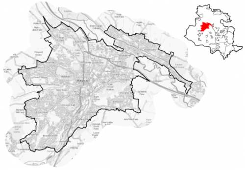
5.12.1 Keighley is the second largest settlement within the Bradford District and the largest within the Airedale sub-area. It is located to the north-west of the District, some 18km to the north west of Bradford, 18km south of Ilkley, 21km north of Halifax, 19km south east of Skipton and 32km north west of Leeds, and is the main service centre for a number of surrounding towns and villages.
Figure 1: Location Map
5.12.2 The town and its setting is defined by the valleys of three watercourses – the River Aire, the River Worth and North Beck. The confluence of the River Worth and the River Aire is located in the Stockbridge area of the town. The River Worth flows through the eastern edge of the town centre, whilst the North Beck flows into the town from the west to join River Worth in the town centre.
5.12.3 Keighley's northern boundary is formed by the edge of Riddlesden with southern limit being the Bracken Bank and Damems areas. To the west, the town advances uphill towards the suburb of Black Hill and it extends eastwards towards the residential neighbourhoods of Long Lee and Thwaites Brow. Riddlesden is an outlying suburb of Keighley located on the northern bank of the River Aire to the north east of the town. It falls within the Keighley Central, Keighley East and Keighley West electoral wards and the Keighley parliamentary constituency. Keighley Town Council acts an administrative body for the parish area.
5.12.4 Keighley has a total population of 49,354. It has a higher percentage of residents (24%) who are aged under 15, compared to the West Yorkshire and national averages (20.6% and 19.2% respectively), whilst it has a slightly below average population of those over 65. The largest percentage (around 67%) of the population identify as being of White British ethnicity which is below the West Yorkshire average of 78.4%. Around 26.7% of the population have identified themselves as of Asian ethnicity, compared with 13.1% in West Yorkshire. Household composition is broadly similar to the sub-regional picture, with the largest number of households (33.3%) consisting of married households.
Planning for Prosperity
5.12.5 The Local Plan settlement hierarchy identifies Keighley is one of Bradford district's three principal towns. This means that it will be a main local focus growth for housing, employment, shopping, leisure, education, health and cultural activities and facilities. There is a key focus on transforming its economic, environmental, physical and social conditions to support its long term regeneration. Keighley is also identified by the Local Enterprise Partnership's as a Spatial Priority Areas for investment to support growth (housing or commercial) and regeneration via public sector investment.
5.12.6 The SPA designation is also related to the town's selection by Government to receive support through the £3.6 billion Towns Fund. The objective of the Fund is to drive the economic regeneration of towns to deliver long term economic and productivity growth. This initiative provides potential to receive up to £25 million of public investment via a Town Deal. Work is progressing on the development of a Town Investment Plan for submission to Government in January 2021. The Local Plan will have a key role in assisting the delivery of the Town Investment Plan.
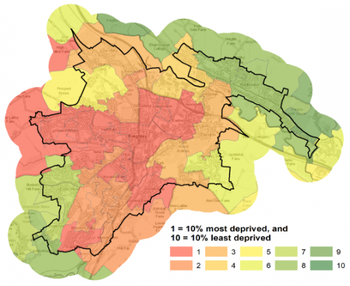
5.12.7 Two of Keighley's wards (Keighley Central and Keighley West) are identified as being amongst the 10% most deprived wards in England. Keighley Central is ranked 6th of 30 wards in the District against the overall Index of Multiple Deprivation[1], whilst Keighley West is ranked 14th and Keighley East ranked 20th.
5.12.8 Keighley Central is ranked in 8th place for income deprivation, 4th place for employment deprivation and 6th place for education, skills and training deprivation. Keighley East ward is in 20th place for income deprivation, employment deprivation and also for education, skills and training deprivation. Figure 2 shows the overall picture of deprivation in Keighley.
Figure 2: Keighley - Level of Multiple Deprivation
Economy and Employment
5.12.9 The economic activity rate in Keighley is lower (66.1%) than the West Yorkshire average of 68.5% and consists of a lower percentage of full-time employees. Annual household income at £35,016 is lower than the West Yorkshire average (£38,499) with the largest employment sectors locally being retail, health and social work and manufacturing. There are higher proportions of people employed in skilled trades and elementary occupations compared to the West Yorkshire averages and less occupied in managerial and administrative occupations and noticeably so in professional occupations (19.9%) compared to West Yorkshire average of 27.9%.
5.12.10 Keighley is the main retail and service centre serving the wider area including the rural hinterlands, and has a large employment base. It benefits from a good labour pool as well as its accessibility to surrounding areas including Bradford, Halifax, Wharfedale, Lancashire and North Yorkshire. A strong manufacturing base is present in the town, based on its long association with the textile industry. It accounts for almost a fifth employment, more than double the national average.
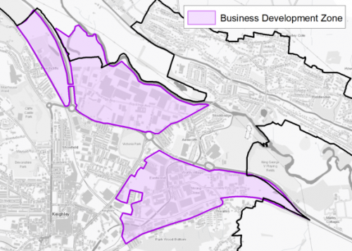
5.12.11 The main employment areas are located along the A650 corridor and Dalton Lane, the town centre and along the valley of the River Worth as well as the A629 corridor running southwards from the town. The Worth Village area and Riverside Business Park are formally designated within the plan as Business Development Zones (see Figure 3 below).
Figure 3: Keighley Business Development Zones
5.12.12 Policy SP6 sets a District employment land requirement of at least 72ha and under policy EC1 it is expected that Keighley will continue to make a contribution to employment land provision through the designated BDZ locations and supporting employment sites within the town and its wider catchment. This contribution is currently estimated at 4.10ha and is significantly lower than originally expected – with a lack of major new employment sites available plus constraints such as flooding and poor access. The priority sectors within Airedale of manufacturing, logistics, professional and final services, and media sectors continue to be supported.
5.12.13 In order to meet the overall target for employment land provision and support the economic ambitions for the town, table A provides details of the preferred employment site allocations within Keighley. The preferred employment site allocations are also identified on the Policies Map and within site pro formas, together with the local strategies map for each plan area.
Retail
5.12.14 As the second largest town in the District, Keighley forms the main retail and service centre serving its surrounding rural hinterlands. Due to its geographically slightly separate location, it has a self-contained centre with a dedicated local catchment population. Keighley is designated in the retail hierarchy (Policy EC4) as a Town Centre.
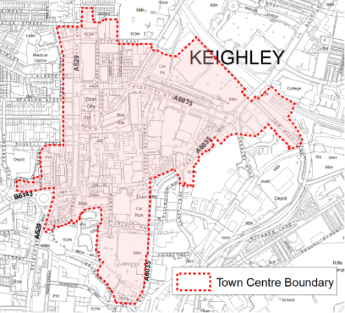
5.12.15 The centre is focused on the Airedale Centre and the surrounding area of Low Street, North Street, East Parade and Cavendish Street. The extent of the Town Centre boundary and Primary Shopping Area are shown on the Policies Map. Figure 4 below shows the town centre area.
Figure 4: Keighley Town Centre
5.12.16 Keighley has a strong historic centre and has attractive areas of recent public realm improvements and is supported by a Business Improvement District (BID). With further public realm improvements, supporting new food and drink uses, Keighley has the potential to build its visitor experience.
5.12.17 The Retail and Leisure Study (2019) suggests that there is not any qualitative need to actively plan for the delivery of new convenience floorspace in Keighley. In relation to new comparison floorspace, it is considered that Bradford City Centre and Keighley Town Centre should be the focus for new comparison retail floorspace in the District.
5.12.18 Potential opportunities to enhance Keighley as a shopping and leisure destination include:
- further investment in the Airedale centre;
- diversifying the range of restaurant offer within the centre;
- reducing traffic dominance
- flexible and innovative approaches to the re-let of vacant units and condensing space,
- addressing issues of crime and anti-social behaviour including perceptions of crime.
5.12.19 The retail hierarchy identifies two small additional Local Centres within the Keighley built up area - situated at Fell Lane / Oakworth Road and Riddlesden which provide day to day needs for the surrounding communities. The boundaries for both centres are shown on the Policies. Fell Lane / Oakworth Road is a relatively healthy local centre with a good range of uses, anchored on good independent, convenience retail, whilst Riddlesden is sufficient to meet the daily and regular needs of local residents, whilst Bradford Road which runs through it provides potential to capture a high proportion of passing trade. Its main challenges are its dispersed nature and the need for environmental improvements.
Transport and Accessibility
5.12.20 Keighley has excellent transport connections with the A650 and A629 providing main road links to/from Bradford, Shipley and Bingley as well as to settlements to the north of the District (Steeton with Eastburn and Silsden) and beyond into North Yorkshire and East Lancashire. The A629 also provides a key link along the Worth Valley towards Haworth as well as Denholme and Halifax. Other minor roads link Keighley to Cullingworth, Harden and Oakworth.
5.12.21 The town also has good public transport links with a frequent train services on the electrified Airedale Line serving Skipton, Bingley, Shipley, Bradford and Leeds. There also other less frequent services to Carlisle (via the Settle and Carlisle line) and Lancaster (via the Bentham line) as well as a daily return service to London Kings Cross (via Leeds). The station will be the subject of a £4 million upgrade by Network Rail. The station is also the northern terminus of the Keighley & Worth Valley Railway (KWVR), a volunteer run, heritage branch line. The line is a major tourist attraction, and a key gateway to Bronte country.
5.12.22 Keighley bus station is located in the town centre and has frequent services running east along the Aire Valley towards Crossflatts, Bingley, Shipley, Bradford and Leeds. The Keighley Jets services provide links between the town centre and surrounding suburbs and villages. Other frequent services operate towards Burnley, Steeton with Eastburn (for Airedale Hospital), Silsden, Ilkley, Skipton and Leeds Bradford Airport as well as Hebden Bridge and Halifax.
5.12.23 National Cycle Route 696, which forms part of the Airedale Greenway, runs through the Riddlesden area along the towpath of the Leeds & Liverpool Canal. This provides an off-road route towards Silsden, Bingley, Shipley, Bradford and Leeds. It is connected to the town centre via an on-road section of cycle lanes.
5.12.24 There are a number of proposals that were put forward for consideration as part of the Towns Fund Town Investment Plan that involve improvements to the public realm (e.g. Low Street and Cavendish Street) and transport network (e.g. traffic management and active travel schemes) in and around Keighley town centre and the Business Development Zones.
5.12.25 The town is located outside the proposed Clean Air Zone (CAZ) and does not feature any designated Air Quality Management Areas (AQMAs). It does however have pockets of traffic congestion through the town centre and surrounding roads and recent notable transport improvements have included Hard Ings Road. In terms of accessibility to car ownership, 34% of households have no car in Keighley compared to 29% in West Yorkshire.
2.12.26 In relation to digital connectivity, average broadband download speeds in Keighley is just over 47 megabytes per second – above the West Yorkshire average, whilst there are 169 premises where speeds are below the Universal Service Obligation (USO)[2]. Further improvements to digital connectivity is a key part of future prosperity.
5.12.27 Strategic transport infrastructure projects to be delivered within the plan period and protected routes are set out on the Policies Map with the local plan. Key initiatives within Keighley are detailed in Table 1 below.
Table 1: Keighley Transport Projects
|
Policies Map Ref. |
Project Name |
|
TR1.C.2 |
Bus Priority Corridor (Bradford Road/Cavendish Street) |
|
TR1.A.5 |
Great Northern Trail (connection from Cullingworth via Cross Roads and Woodhouse) |
Planning for Homes
5.12.28 According to census data, Keighley has 19,868 dwellings of which 66.2%, are owner occupied which is slightly higher than the West Yorkshire average of 63.4%. In term of housing type, Keighley has a much higher percentage of terraced stock at 40.8% compared to the West Yorkshire average at 30.7% or indeed the national average at 24.5%. Further information on dwelling types is detailed below in Figure 5.
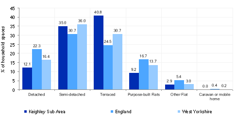
Figure 5: Keighley – Housing Type
5.12.29 Around a quarter of the stock was built before 1900, with 26.6% being developed between 1900 and 1939, with 38.6% being constructed between around 46% in the post war period (1945 to present). The average house price for Keighley is £127,490, compared with a West Yorkshire average of £183,194. This significant variation in average house prices is illustrated across all dwellings types as detailed in Figure 6
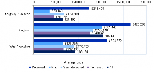
Figure 6: Keighley – Average House Prices by Dwelling Type
5.12.30 The lower quartile house price gap for Keighley of minus £54,664 is broadly on par with West Yorkshire and is defined as the difference between cheaper more affordable housing in the area and 4.5 times local annual earnings. Higher figures represent more unaffordable housing.
5.12.31 Figures suggest that the population density for Keighley (24.6 persons per hectare) is well over double that of West Yorkshire as a whole (11.4) with a higher percentage of houses lacking central heating compared to the sub-regional average and a marginally higher percentage of overcrowded housing and vacant dwellings than the West Yorkshire averages.
5.12.32 The delivery of new housing is a key part of the overall development strategy for Keighley. It will ensure that the housing needs and aspirations of local people can be met, together with those of future residents, including the provision of market and affordable housing. In addition, it will support the economic and regeneration aspirations for the town, as well as its position as a Principal Town.
5.12.33 Policy SP8 in the local plan sets out a requirement of 2,200 dwellings that will be delivered in Keighley during the plan period. These will be delivered through a mix of committed sites (those under construction or have planning permission but have not yet commenced) and allocations. Table 2 below sets out the housing position for Keighley, which also includes the application of non-implementation or discount rates for planning permissions and allocations.
Table 2: Keighley - Summary of Housing Requirement and Supply
|
Housing Target |
2,200 units |
|
Carried Forward Commitments |
552 |
|
Commitment Discounted by 10% |
497 |
|
Remaining Allocation Requirement |
1,703 |
|
Identified Allocations |
1,693 |
|
Allocations Discounted by 10% |
1,524 |
|
Area of Search (Town Centre/Station Quarter) |
250 (E) |
|
Total Supply Contribution from Allocations and Area of Search |
1,774 |
5.12.34 Once the commitments are discounted and removed from the supply this leaves a residual allocation requirement of 1,703 units. The evaluated total site supply of housing units from preferred allocation sites equates to 1,693 units which is in turn discounted by 10% for non-implementation leaving a final allocation contribution of 1,524 units across all sites. Further work is being undertaken on regeneration and housing capacity within the town centre and station quarter and an estimated yield of 250 dwellings has been included within this plan as work progresses to finalise numbers.
5.12.35 In line with the strategic focus for the plan on the use of previously developed land and maximising regeneration opportunities, the vast majority of the new allocations will be delivered on brownfield and non-Green Belt sites opportunities within the settlement. The Council will be supportive of additional proposals for new homes on additional small sites, particularly those that provide a redevelopment opportunity to bring forward land which has been previously used. Support will also be provided to developers who wish to redevelop larger sites and/or buildings for new homes not currently identified, subject to all relevant policies in the Local Plan. In delivering the target for new homes in Keighley it has been necessary to make some changes to the adopted green belt. Policy SP5 sets out the Councils approach and justification for green belt releases to accommodate new development and lists the sites proposed for allocation which current lie within or partly within the green belt
5.12.36 The new local plan preferred site allocations for residential and mixed allocations to meet Keighley's housing requirement are set out in Table B and identified on the Policies Map and the Site Proformas below together with the local strategies map for each plan area. Development of site allocations should be in accordance with specified development guidelines and approximate site provision figures and all other relevant policies of this Local Plan.
Planning for Places and Communities
Green Belt, Natural Landscape and Historic Character
5.12.37 Keighley is located primarily on the valley floors of the Rivers Aire and Worth. The Aire valley is a distinct U shaped valley with contrasts between the open exposed upland pastures and busy settlements at the valley bottom. Due to the town's location, it is heavily constrained by its topography, which affects the potential locations for future growth and development. This landscape acts as a backdrop to the town and is designated as Green Belt. This land falls within the Airedale Character Area to the north east, Worth and North Beck Valley Character to the south west; and Wilsden Character Area to the south east. The majority of this landscape is of high sensitivity with areas of low sensitivity along the A650 to the north below Riddlesden and Micklethwaite.
5.12.38 There are five Conservation Areas within Keighley (Braithwaite; Devonshire Park and Cliffe Castle; Keighley Town Centre; Leeds and Liverpool Canal & Low Utley). Lund Park and the gardens of Whinburn are considered to be nationally important sites and have been included in the Register of Parks and Gardens of Special Historic Interest in England. Cliffe Castle and Devonshire Park is a park and garden which is recognised as having local value.
5.12.39 There are a total of 181 Listed Buildings within the town, the majority of which (174) are Grade II Listed. There are two Grade I Listed Buildings - West Riddlesden Hall and East Riddlesden Hall, and a number which are Grade II* Listed (Keighley War Memorial; Former Mill Buildings at Low Mills; Dalton Mills). Two Scheduled Monuments are found close the edge of the built up area. The town centre was the subject of a Townscape Heritage Initiative, funded by a £2.7 million grant from the Heritage Lottery Fund and Bradford Council. This ran for six years between 2011 and 2017, and contributed towards the regeneration of North Street, Church Street, Bridge Street, and parts of High Street and Low Street.
Green Infrastructure, Ecology, Open Space and Flood Risk
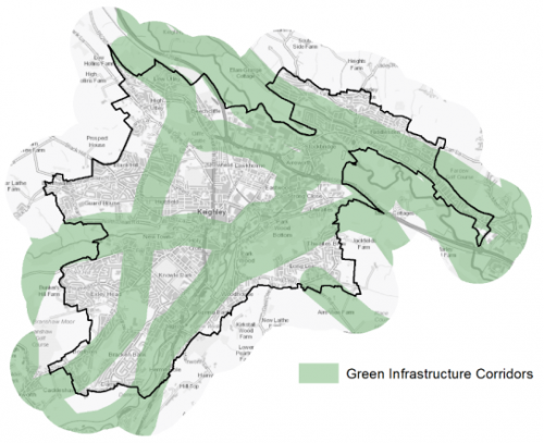
5.12.40 The town has a range of corridors and spaces that contribute towards its Green and Blue Infrastructure. Key corridors include the valleys of the Rivers Aire and Worth as well as North Beck. As well as the river valleys these corridors also include a number key open spaces and areas of woodland and open land on the upper slopes. The corridors also give a strong connection between the urban area and the surrounding countryside. Figure 7 below shows these corridors.
Figure 7: Green Infrastructure Corridors
5.12.41 There are number of biodiversity designations within or close proximity to Keighley urban area in the form of 11 Local Wildlife Sites (LWS). The Leeds and Liverpool Canal LWS runs through the Riddlesden area, whilst the How Beck Wood LWS is also within this area. Park Wood LWS is within a green corridor in the built up area that separates the Parkwood and Long Lee areas. Beechcliffe Ings LWS and Beechcliffe Ox-bow LWS is within and adjacent to (north of) the Royd Ings employment area within the Hawkcliffe Wood LWS and Elam Wood LWS being located on either side of the Aire Valley to the north west of the town. Holme House Wood and Grassland LWS forms part of the North Beck valley to the west. Hainworth Wood LWS and Whins Wood LWS are on the south eastern edge of the built up area. The Stockbridge Nature Reserve LWS is on the northern bank of the River Aire, close to Riddlesden St Mary's CE Primary School.
5.12.42 The South Pennine Moors (Phase 2) SPA and SAC (and SSSI) are located around 1.1km and 3.5km to the north east and south west of Keighley respectively, placing the north eastern part of the town within the 2.5km buffer zone with the remainder being within 7km buffer. There are also three areas of Ancient Woodland within/adjacent to the urban area – Parkwood, Hainworth Wood and Lower Holme Wood.
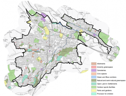
5.12.43 In addition, there are 172 sites identified as open space covering an area of around 297ha. Key sites within and around Keighley include Cliffe Castle Park, Devonshire Park, Lund Park, Victoria Park, Utley Cemetery, Branshaw Golf Course and Marley Playing Fields. Figure 8 below provides an overview of the town's open spaces. Provision is generally good for most types of provision, although there are some disparities between the distribution of spaces in the different localities within the settlement. It noted that most typologies were well catered for and perform well against the provision standards, however there are a limited number of typologies with deficiencies including amenity green space and parks and gardens. Additional provision should focus on these typologies in particular in Central Keighley, when opportunities arise.
Figure 8: Keighley - Open Space Overview
5.12.44 Keighley's location on the valleys of three watercourses means that parts of the town are identified as being at risk of flooding particularly along the northern entrance to the town and associated River Aire corridor, this restricts development opportunities within this corridor area.
Community Infrastructure – Education, Health and Utilities
5.12.45 Keighley has a wide range of community facilities to meet the day to day needs of local people. These include post offices, places of worship, community halls/centres, playgrounds, a leisure centre and swimming pool, a library and various sporting facilities. There is also an active community and voluntary sector that play an important role within the town supporting local people.
5.12.46 The town is served by 14 primary schools, three of which a Roman Catholic schools, which have the capacity to accommodate 5,115 pupils. Most schools are under capacity, with only four being over capacity. The three secondary schools (Holy Family Catholic School, Oakbank School and University Academy Keighley), have the capacity to accommodate 3,689 pupils, but are currently below capacity.
5.12.47 As well as pupils from Keighley, the schools also draw pupils from the surrounding area. In addition to the 6th Form provision at local secondary schools, students have the opportunity to access post 16 education at Keighley College, which is located adjacent to the town's railway station. The current £30m campus opened in 2010. Other nearby Further Education colleges include Craven College in Skipton, Bradford College and Shipley College as well as the universities in Bradford and Leeds.
5.12.48 Pupil attainment levels at Key Stage 4 (GCSE) is below the West Yorkshire and national (England) average scores – 321.9 compare to 353.5 and 366.3 respectively. As part supporting a prosperous economy in Keighley, as well as across the district, it will be important to ensure that local people have the skills needed or the access to the opportunities for upskilling. Policy EC3 sets out the council's approach.
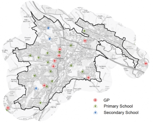
5.12.49 Keighley has a number of NHS registered healthcare facilities within the town. There are six GP surgeries/health centres, with 42 GPs, catering for 55,063 registered patients in Keighley and the surrounding area, including Crossflatts, Cross Roads, Cross Hills, Oakworth and Steeton with Eastburn. Another surgery in Oakworth also serves part of Keighley. Secondary (acute) healthcare is provided at Airedale General Hospital in Eastburn, around 3km to the north west. Average life expectancy at birth for Keighley residents is 76 for men and 81 for women, which is similar to the West Yorkshire and England average. Healthy life expectancy is 60 for both men and women. Figure 9 shows the location of schools and medical facilities in the town.
Figure 9: Schools & Medical Facilities in Keighley
5.12.50 When planning for the long-term development of Keighley, it is vital that new development is supported by the appropriate infrastructure. The capacity, quality and accessibility of services and facilities are all key components in ensuring people can enjoy living, working and visiting the area. The council will continue work with key infrastructure providers and others including the Local Education Authority, Clinical Commissioning Group and utilities providers to determine the impacts of future growth and development on local infrastructure capacity and provision. Further infrastructure details will be published through the Local Infrastructure Plan and as part of the Regulation 19 stage of the local plan.
Local Area Strategies
5.12.51 This section of the plan breaks down Keighley into a series of local areas with supporting spatial strategies. It builds upon earlier section information to provide further context and directions for growth.
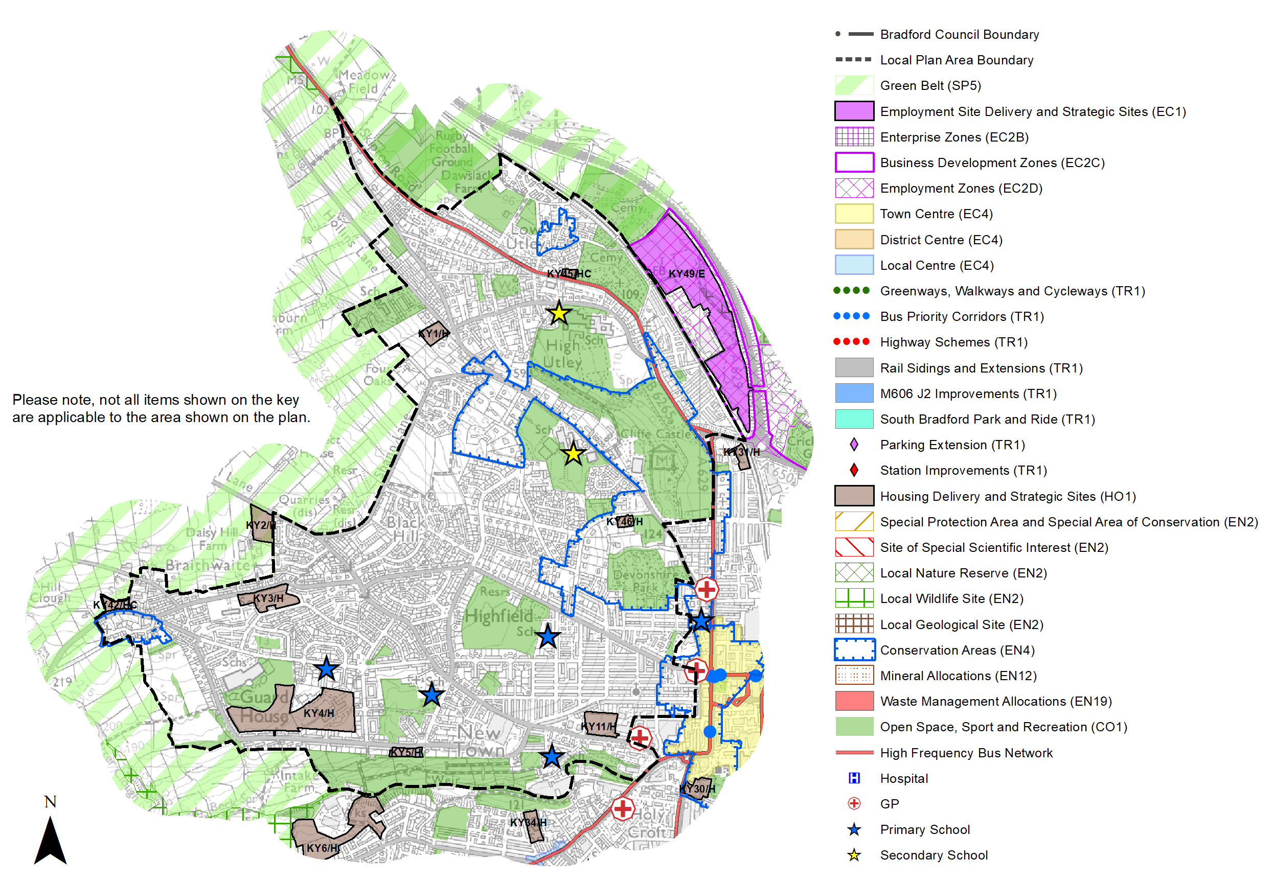
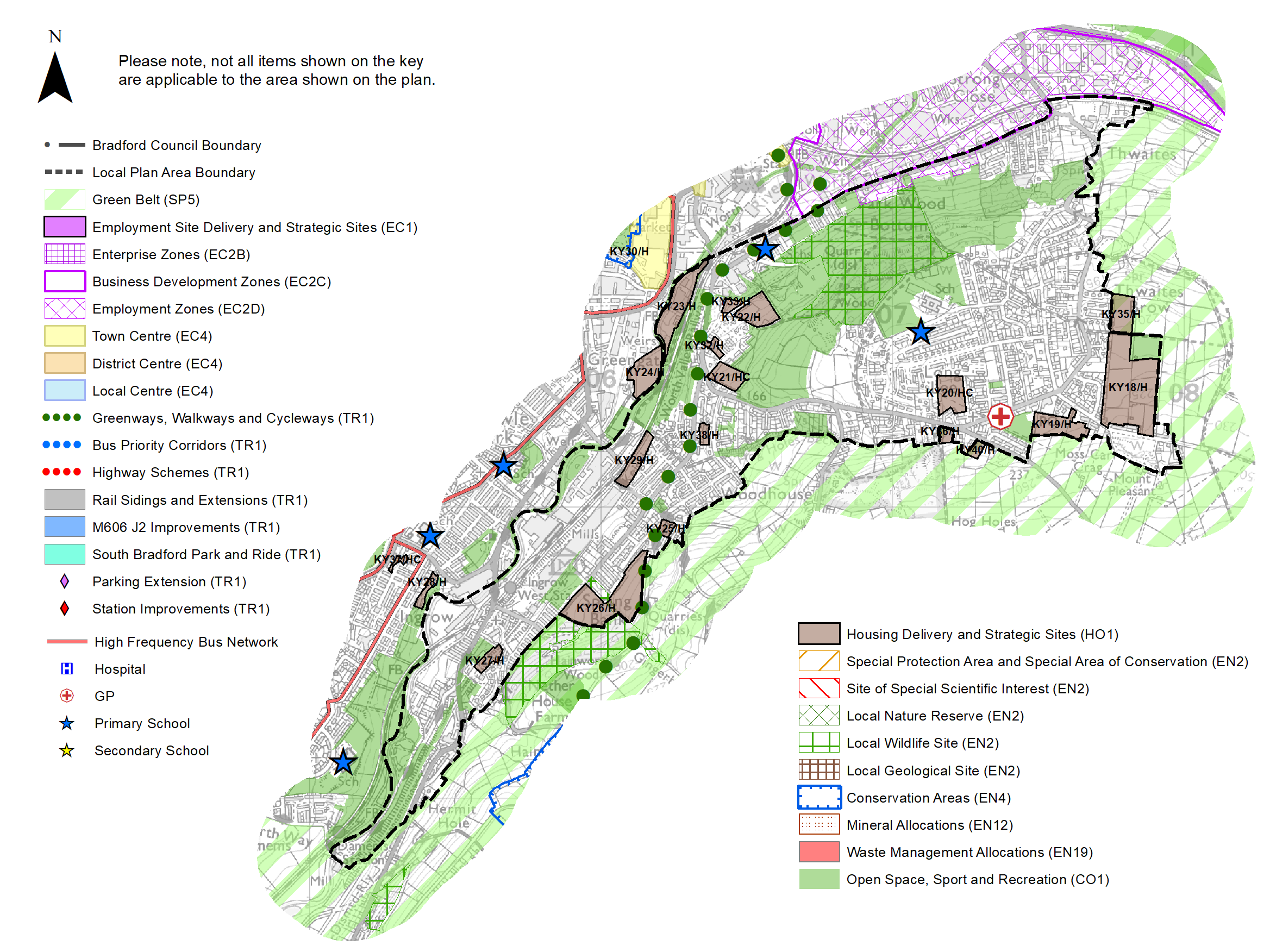
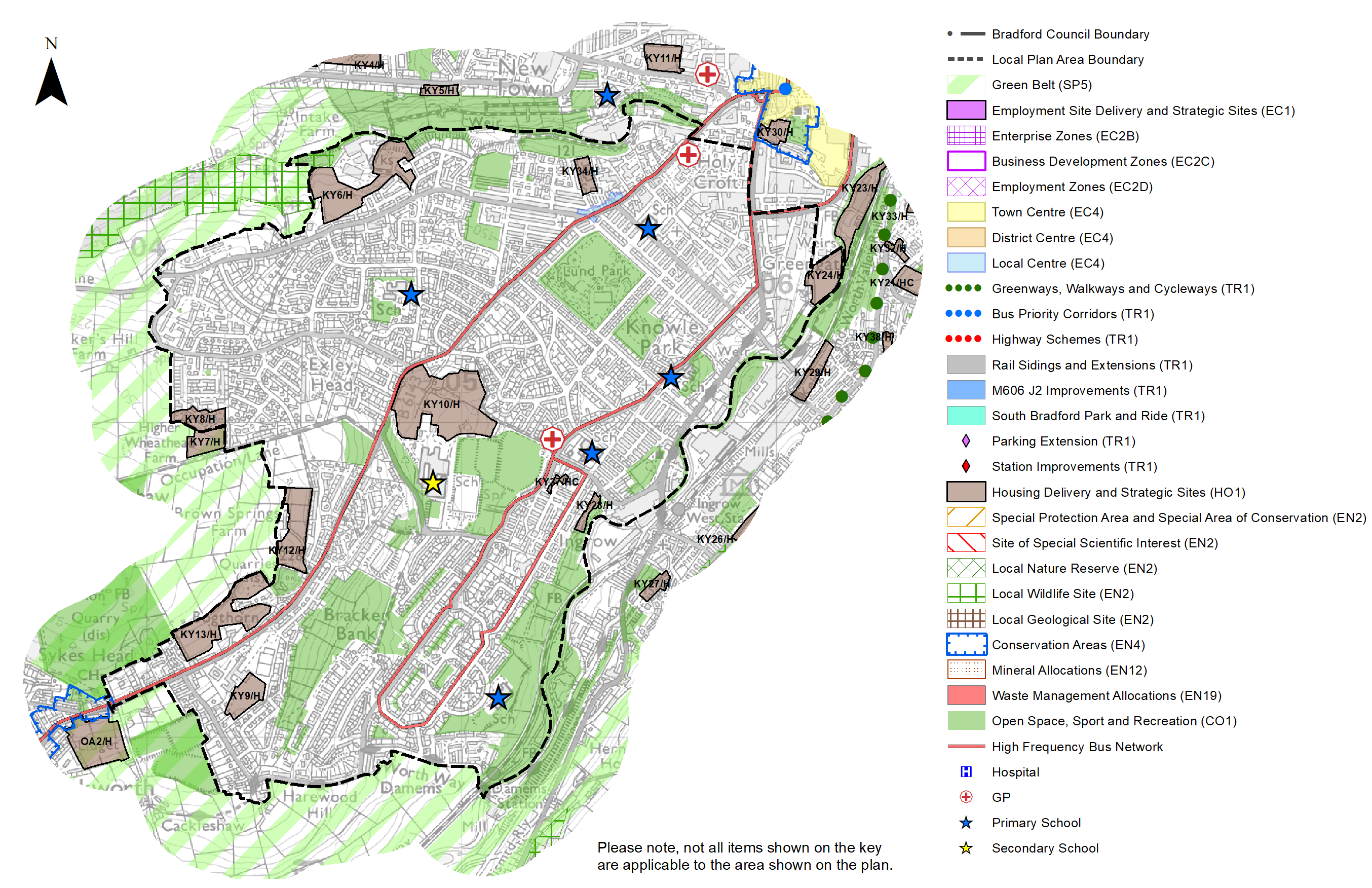
Figure 10: Keighley Local Strategy Areas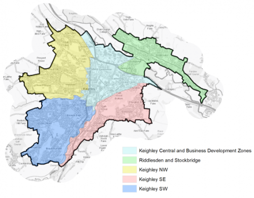
|
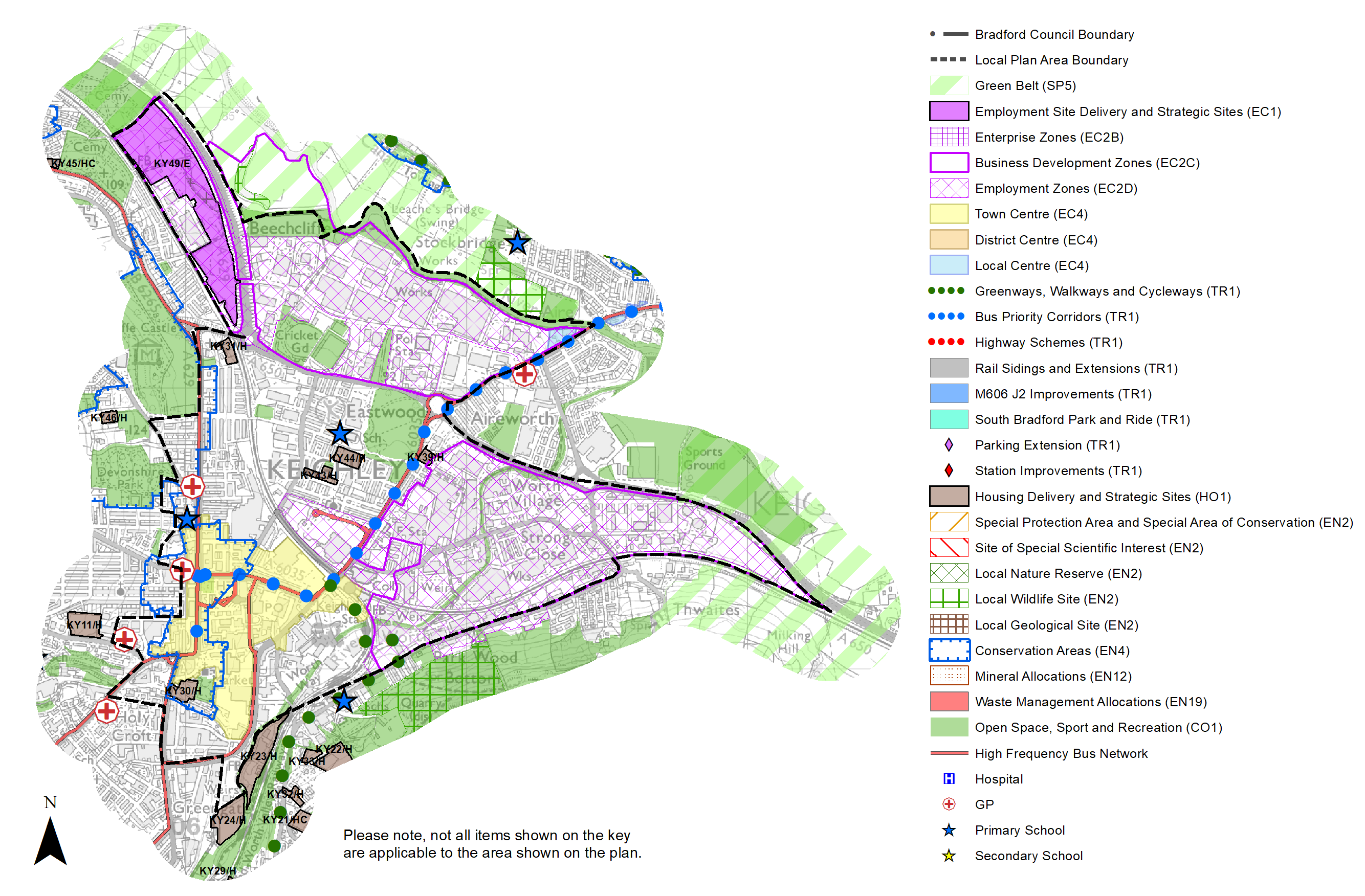
Local Area Strategy and Plan- Keighley Central & Business Development Zones |
|
The key elements of the local area strategy for central Keighley and the Business Development Zones (BDZ) include:
|
|
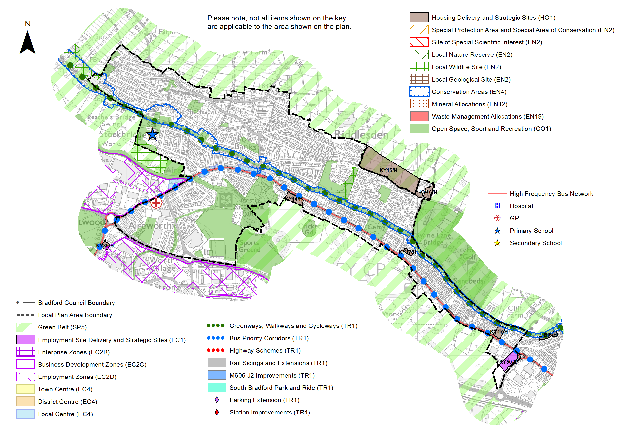
Local Area and Strategy - Riddlesden and Stockbridge |
|
The key elements of the local area strategy for Riddlesden and Stockbridge include:
|
|
Local Area Strategy and Plan - Keighley North West |
|
The key elements of the local area strategy for Keighley North West include:
|
|
Local Area Strategy and Plan - Keighley South East |
|
The key elements of the local area strategy for Keighley South East include:
Protecting and enhancing existing open spaces, green spaces, networks and corridors as well as incorporating sufficient green spaces and connections within new development. Key corridors include the River Worth, Hainworth Wood and Parkwood. Reinforcement of the River Worth corridor is a key aspiration;
|
|
Local Area Strategy and Plan - Keighley South West |
|
The key elements of the local area strategy for Keighley South West include:
|
(7) Consultation Question 106
Local Area Strategy – Keighley Central and BDZ area
The Local Plan sets out a series of local area strategies for Keighley.
Q. Please provide any comments you may have on the area strategy?
If you have an alternative to the approaches undertaken, please provide further details and evidence in support.
(19) Consultation Question 107
Local Area Strategy – Riddlesden and Stockbridge
The Local Plan sets out a series of local area strategies for Keighley.
Q. Please provide any comments you may have on the area strategy?
If you have an alternative to the approaches undertaken, please provide further details and evidence in support.
(5) Consultation Question 108
Local Area Strategy – Keighley North West
The Local Plan sets out a series of local area strategies for Keighley.
Q. Please provide any comments you may have on the area strategy?
If you have an alternative to the approaches undertaken, please provide further details and evidence in support.
(19) Consultation Question 109
Local Area Strategy – Keighley South East
The Local Plan sets out a series of local area strategies for Keighley.
Q. Please provide any comments you may have on the area strategy?
If you have an alternative to the approaches undertaken, please provide further details and evidence in support.
(9) Consultation Question 110
Local Area Strategy – Keighley South West
The Local Plan sets out a series of local area strategies for Keighley.
Q. Please provide any comments you may have on the area strategy?
If you have an alternative to the approaches undertaken, please provide further details and evidence in support.
Preferred Site Allocation and Site Pro Formas
5.12.52 The preferred site allocations for Keighley for both employment and housing are detailed below in Tables A and B. These tables are subsequently followed by site pro formas for each preferred site allocation proving a summary of key site information and characteristics.
Table A: Keighley Employment Sites - Preferred Allocations
|
Site Ref |
Site Name |
Type |
Site Area (Gross Hectares) |
Local Area |
|
KY49/E |
Beechcliffe |
Greenfield - BDZ |
3.30 |
Keighley Central |
|
KY50/E |
Bradford Road |
Greenfield |
0.8 |
Keighley Central |
|
Total |
4.10 |
Table B: Keighley Housing & Mixed Use Sites - Preferred Allocations
|
Site Ref |
Site Name |
Dwellings |
Local Area |
|
KY1/H |
Hollins Lane |
16 |
Keighley NW |
|
KY2/H |
Black Hill Lane |
28 |
Keighley NW |
|
KY3/H |
Whinfield Drive |
39 |
Keighley NW |
|
KY4/H |
Braithwaite Avenue |
173 |
Keighley NW |
|
KY5/H |
North Dean Road |
12 |
Keighley NW |
|
KY6/H |
Holme Mill Lane* |
102 |
Keighley SW |
|
KY7/H |
Wheathead Lane |
22 |
Keighley SW |
|
KY8/H |
Higher Wheathead Farm |
29 |
Keighley SW |
|
KY9/H |
Former Bronte School Playing Fields |
41 |
Keighley SW |
|
KY10/H |
Exley Road/Oakworth Road |
125 |
Keighley SW |
|
KY11/H |
West Lane |
48 |
Keighley NW |
|
KY12/H |
Keighley Road (1), Exley Head |
61 |
Keighley SW |
|
KY13/H |
Keighley Road (2), Exley Head |
80 |
Keighley SW |
|
KY14/H |
Bradford Road, Riddlesden |
22 |
Riddlesden and Stockbridge |
|
KY15/H |
Carr Bank (1), Riddlesden |
139 |
Riddlesden and Stockbridge |
|
KY16/H |
Carr Bank (2), Riddlesden |
16 |
Riddlesden and Stockbridge |
|
KY17/H |
Former Church of Christ the King, Riddlesden |
14 |
Riddlesden and Stockbridge |
|
KY18/H |
Moss Carr Road (1), Long Lee |
103 |
Keighley SE |
|
KY19/H |
Moss Carr Road (2), Long Lee |
39 |
Keighley SE |
|
KY20/HC |
Redwood Close |
45 |
Keighley SE |
|
KY21/HC |
Parkwood Rise (1) |
28 |
Keighley SE |
|
KY22/H |
Parkwood Rise (2) |
33 |
Keighley SE |
|
KY23/H |
The Walk |
55 |
Keighley SE |
|
KY24/H |
Marriner Road |
30 |
Keighley SW |
|
KY25/H |
Hainworth Road |
6 |
Keighley SE |
|
KY26/H |
Hainworth Wood Road |
75 |
Keighley SE |
|
KY27/H |
Hainworth Lane/Halifax Road |
11 |
Keighley SE |
|
KY28/H |
Staveley Way |
10 |
Keighley SW |
|
KY29/H |
Woodhouse Road |
24 |
Keighley SE |
|
KY30/H |
Beck Lane/Bridge Street |
39 |
Keighley Central |
|
KY31/H |
Cark Road |
11 |
Keighley Central |
|
KY32/H |
James Street East |
10 |
Keighley SE |
|
KY33/H |
Parkwood Rise |
7 |
Keighley SE |
|
KY34/H |
Former Branshaw School |
30 |
Keighley SW |
|
KY35/H |
Land off Golden View Drive, Thwaites |
30 |
Keighley SE |
|
KY36/H |
Long Lee Lane |
13 |
Keighley SE |
|
KY37/HC |
Former Ingrow Corn Mill |
9 |
Keighley SW |
|
KY38/H |
Worthville Farm, Dawson Avenue |
10 |
Keighley SE |
|
KY39/H |
Bradford Road |
16 |
Keighley Central |
|
KY40/H |
The Bungalow, Harden Road, Long Lee |
6 |
Keighley SE |
|
KY42/HC |
Ryan Grove |
6 |
Keighley NW |
|
KY43/H |
Grange Road |
25 |
Keighley Central |
|
KY44/H |
Parson Street |
35 |
Keighley Central |
|
KY45/HC |
Former Mortuary, Skipton Road |
5 |
Keighley NW |
|
KY46/H |
Land at Woodville Road* |
7 |
Keighley NW |
|
KY47/H |
Former site of Sandbeds Methodist Church, Swine Lane* |
8 |
Riddlesden and Stockbridge |
|
Total |
1,693 |
Note: Sites labelled "HC" have outline planning permission and as such the principal of development has been accepted subject to detailed matters being addressed thorough a reserved matters application. Sites KY6/H, KY46/H and KY47/H gained planning permission after 1st April 2020.
(28) Consultation Question 111
Keighley Site Allocations and Site Pro Formas
The Local Plan sets out a series of preferred site allocations. If you wish to make representations on any of the sites proposed, please provide site reference and feedback under this question.
If you wish to propose an additional or alternative site(s) to the preferred allocations listed, please also provide a plan with a red line and any further details in support.
[1] Where 1 is the most deprived (Manningham Ward) and 30 is the least deprived (Wharfedale)
[2] Universal Service Obligation (USO) - download speeds at or above 10Mbit/s and upload speeds at or above 1Mbit/s including non-matched records and zero predicted speeds
(6) KY49/E - Beechcliffe
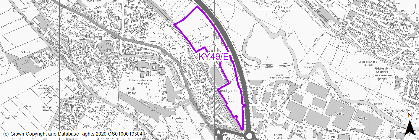
Site location
Principal Town - Keighley
Ward
Keighley Central
Site description
Green field site with significant amount of tree coverage within Business Development Zone.
Proposed Allocation
Employment
SHLAA referencce
KY/177
Indicative no. dwellings
N/A
Site area (Gross) (ha)
3.3
Ownership
Public / Private
Delivery timescales
2025-30
Type (PDL/Greenfield)
Greenfield - 100%
Green Belt
No
Flood Zone
Flood Zone 3b around Beechcliffe Ings pond. Southern section relatively unaffected.
Potential site access
Site can be accessed from Royds Ings Avenue through industrial estate but will require improvement to facilitate development of this site.
Public Transport Accessibility
Bus Stop within 400m Frequent service
Sustainability Appraisal
The site has been proposed for employment development, which would be likely to deliver a major boost to the range of local employment opportunities at this location whilst also providing a boost to the local economy. A major positive score has therefore been predicted for the employment and economy themed SA Objectives.
A major adverse effect arises for the climate change resilience SA Objective due to 40% of the site falling within Flood Zone 3b and a limited area at high risk of surface water flooding. More detailed flood risk assessments would likely be required for the site, and careful consideration given to the layout of the development.
The large waterbody present within the site boundary and an unnamed stream running adjacent to the eastern perimeter lead to an additional significant adverse effect being predicted on the water resources SA Objective. The construction and occupation of the site could pose a risk to water quality here.
A third major adverse effect is due to the site’s location 25m east of the Utley Cemetery Registered Park/Garden, within which is a Grade II Listed Building. The site is also in proximity to two Conservation Areas. Development at this large greenfield site could potentially result in an adverse alteration to the setting of this highly sensitive historic area and nearby heritage assets.
Minor positive effects were predicted for other socio-economic themed SA Objectives due to the additional benefits of a new employment site, such as the potential for increasing the local offering of services and amenities and opportunities to learn new skills.
Minor adverse effects were predicted for the remaining natural environment themed SA Objectives, primarily as a result of the impacts of new development on a 100% greenfield site which contains an LWS. The site falls within the Impact Risk Zones of South Pennine Moors SAC/SPA/SSSI and depending on the scale and type of employment development here, consultation with Natural England may be required as part of any planning application in order to ensure no adverse effects on the SAC/SPA/SSSI.
Habitats Regulations Assessment
This site falls within 7km of the South Pennine Moors SPA/SAC a HRA must be undertaken to ensure there are no significant effects on these protected sites. Developments within these zones must comply with Policy SP11; an SPD is being produced to provide further guidance.
Green Belt
N/A – Site not within the Green Belt.
Constraints and Opportunities
• Within close proximity to Beechcliffe Ings trees and hedgerow cover large areas of the site and is situated within a GI corridor.
• Part of the site forms part of the grassland habitat network and washlands with semi-improved/ improved grassland, scattered scrub/ trees.
• Site contains multiple landfills and need for site investigation and potential remediation.
• Flood Zone 3b around Beechcliffe Ings pond. Southern section relatively unaffected.
• Site is located with a BDZ for which improvements to business space and the wider environment is promoted.
• North section of the site is within close proximity to cemetery and Utley Cemetery Historic Park and Garden.
• Limited access options to north section of the site.
Development considerations
• Site access through Royd Ings Avenue may require improvements.
• Sensitive site in terms of ecological assets and this will need to be fully considered as part of any scheme design.
• Waterbody within the site may restrict development options.
• Within close proximity to existing businesses.
• Southern section of the site identified for employment development only due to site constraints.
Conclusion/Summary
Site forms part of wider BDZ and there may be opportunities to develop part of the site for employment uses and retain a strong green infrastructure / landscape aspect to other areas. The southern section of the overall site is primarily identified for employment uses and this is reflected in the site yield.
Use Class
Class B2/B8
(4) KY50/E - Bradford Road
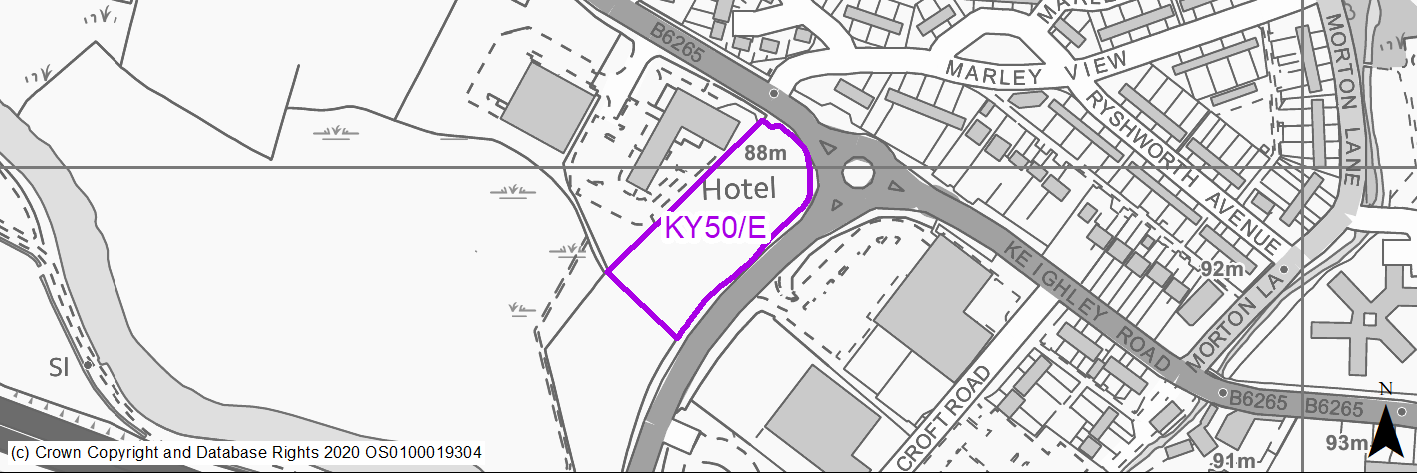
Site location
Principal Town - Keighley
Ward
Keighley East
Site description
Green field site at roundabout junction of the A650 Airevalley Road.
Proposed Allocation
Employment
SHLAA referencce
KY/050
Indicative no. dwellings
N/A
Site area (Gross) (ha)
0.8
Ownership
Private
Delivery timescales
2025-30
Type (PDL/Greenfield)
Greenfield - 100%
Green Belt
No
Flood Zone
Flood Zone 1 - low risk of flooding within site area. Flood Zone 3b immediately to the south of the site.
Potential site access
Site could be accessed from Bradford Road and B6265 but a suitable access location requires further investigation.
Public Transport Accessibility
Bus Stop within 400m Frequent service
Sustainability Appraisal
The site has been proposed for employment development, which would be likely to deliver a major boost to the range of local employment opportunities at this location whilst also providing a boost to the local economy. A major positive score has therefore been predicted for the employment and economy themed SA Objectives. The site technically lies within FZ1 but immediately borders functional floodplain.
More detailed flood risk assessments would likely be required for the site, and careful consideration given to the layout of the development.
Minor positive effects were predicted for other socio-economic themed SA Objectives due to the additional benefits of a new employment site, such as the potential for increasing the local offering of services and amenities and opportunities to learn new skills.
Minor adverse effects have been predicted for a range of natural environment themed SA Objectives, primarily as a result of the impacts of new development on a 100% greenfield site. Additionally, the site falls within the Impact Risk Zones for South Pennine Moors SAC/SPA/SSSI. Depending on the scale and type of employment development here, consultation with Natural England may be required as part of any planning application in order to ensure no adverse effects on the SAC/SPA/SSSI.
Habitats Regulations Assessment
This site falls within 7km of the South Pennine Moors SPA/SAC a HRA must be undertaken to ensure there are no significant effects on these protected sites. Developments within these zones must comply with Policy SP11; an SPD is being produced to provide further guidance.
Green Belt
N/A – Site not within the Green Belt.
Constraints and Opportunities
• Site is located within GI corridor.
• Entire site contains landfill.
• North western edge of the site within gas pipeline buffer.
• The site technically lies within FZ1 but immediately borders functional floodplain - More detailed flood risk assessments would likely be required for the site, and careful consideration given to the layout of the development.
• Significant drainage infrastructure investment required.
• Within close proximity to Green Belt.
• Close relationship to hotel and other commercial uses.
Development considerations
• Development envelope will need to take into consideration proximity to floodplain and relationship to nearby hotel.
• Prominent corner site which will require sensitive design treatment in relation to wider landscape.
• Access and drainage infrastructure constraints will need to be addressed.
Conclusion/Summary
Commercially well located small employment site within close proximity to business uses which will require a sensitive approach to design to minimise potential impact on the wider landscape.
Use Class
Class B2/B8
(4) KY1/H - Hollins Lane
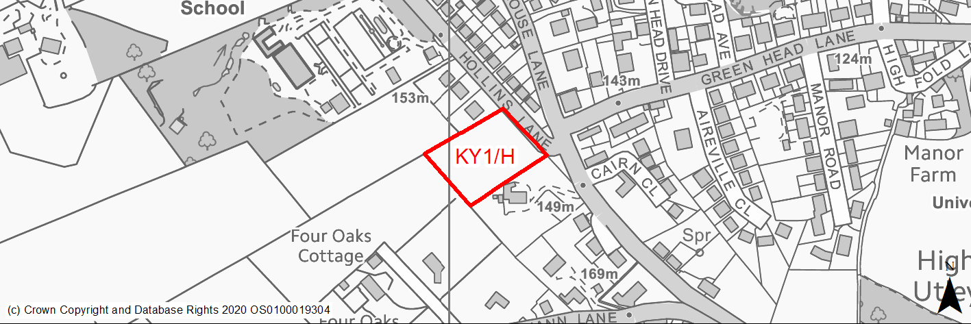
Site location
Principal Town - Keighley
Ward
Keighley Central
Site description
This site consists of a number of fields used for animal grazing.
Proposed Allocation
Housing
SHLAA referencce
KY/003a
Indicative no. dwellings
16
Site area (Gross) (ha)
0.51
Ownership
Private
Delivery timescales
Developable (6-10 years)
Type (PDL/Greenfield)
Greenfield
Green Belt
No
Flood Zone
Flood Zone 1
Potential site access
Access is via narrow track from Shann Lane. Alternative access is could be via Hollins Lane.
Public Transport Accessibility
Bus: The site is within 400m of a bus service with 4+ buses per hour to key settlements. The nearest stops are located on Skipton Road (circa 360m from the site). These offer 6 services per hour towards Keighley Bus Station (inbound) and Burnley (2 per hour), Ilkley (1 per hour), Leeds Bradford Airport (1 per hour) & Skipton (2 per hour_ (outbound). There is also limited service between Keighley and Silsden via Steeton & Airedale Hospital. Services 60, 66, 903 & M4.
Rail: Keighley railway station is located around 2km to the south west.
Sustainability Appraisal
Major adverse effects have been predicted for the site’s impact on the cultural heritage SA Objective due to its location 60m south-east of to Whinburn Registered Park/Garden, within which are three Grade II Listed Buildings, and its proximity to a listed building.
Minor positive effects were predicted for most socio-economic themed SA Objectives due to the benefits of new residential development for the local economy as well as the location of the site in relation to transport links, education facilities and employment areas.
Minor adverse effects were predicted for a range of natural environment themed SA Objectives, primarily as a result of the impacts of new development on a greenfield site with adjacent TPO woodland and trees.
Habitats Regulations Assessment
This site falls within 7km of the South Pennine Moors SPA/SAC. A HRA must be undertaken to ensure there are no significant effects on these protected sites. Developments within these zones must comply with Policy SP11; a SPD is being produced to provide further guidance.
Green Belt
N/A – Site not within the Green Belt.
Constraints and Opportunities
• This is a steeply sloping, greenfield site located within the Keighley built up area, in an established residential area that has good access to local schools.
• The site is located close to the Whinburn Lodge (Grade II Listed Building/Listed Park & Garden), whilst there is potential for landscape and visual impacts due to the sloping nature of the site.
• Several TPOs and areas of TPO woodland are present within and adjacent to the site.
• It is within the 7km buffer of the SPA/SAC.
Development considerations
• Heritage impact assessment required to determine and mitigate impacts on the setting of adjacent heritage assets.
• Surface water flooding and drainage issues should mitigated.
• Sensitive design and layout will be required to mitigate potential landscape and visual impacts.
• Green infrastructure should be included with the layout.
• Ecological assessment required.
• Access could be created off Hollins Lane but it will need widening. Off site highway works would also likely to be required.
Conclusion/Summary
This is a sustainably located site within the settlement boundary with good access to local services including secondary schools as well as frequent public transport services. It will deliver an estimated 16 dwellings.
(8) KY2/H - Black Hill Lane
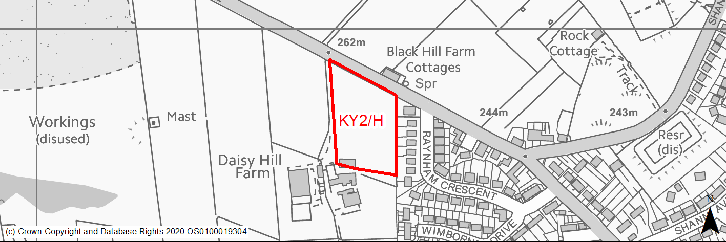
Site location
Principal Town - Keighley
Ward
Keighley West
Site description
The site consists of an agricultural field and part of a building that form part of Daisy Hill Farm, adjoining the western edge of the built up area.
Proposed Allocation
Housing
SHLAA referencce
KY/009A
Indicative no. dwellings
28
Site area (Gross) (ha)
0.89
Ownership
Private
Delivery timescales
Developable (6-10 years)
Type (PDL/Greenfield)
Greenfield
Green Belt
Yes
Flood Zone
Flood Zone 1
Potential site access
Access is available from Black Hill Lane via an existing access track to Daisy Hill Farm.
Public Transport Accessibility
Bus: The nearest bus stop is located around 32m to the east of the site on Raynham Crescent. This provides an hourly service during the day to Keighley Bus Station (Service K12).
Rail: Keighley railway station is located around 2.2km to the south east.
Sustainability Appraisal
The site could deliver a major positive effect for residents on the education SA Objective, as a result of being within the target distance for both primary and secondary education facilities.
Minor positive effects were predicted for some socio-economic themed SA Objectives due to the benefits of new residential development for the local economy as well as the location of the site in relation to transport links and health facilities.
No major adverse effects have been predicted for the site, but minor adverse effects were predicted for a range of natural environment themed SA Objectives, primarily as a result of the impacts of new development on a 100% greenfield site with an adjacent strip of TPO trees.
Habitats Regulations Assessment
This site falls within 7km of the South Pennine Moors SPA/SAC. A HRA must be undertaken to ensure there are no significant effects on these protected sites. Developments within these zones must comply with Policy SP11; a SPD is being produced to provide further guidance.
Green Belt
See individual Green Belt site assessment in the accompanying report.
Constraints and Opportunities
• This is a gently sloping, greenfield site within the Green Belt, adjacent to the settlement boundary for Keighley.
• It is an agricultural field bounded by dry stone walling, a farm track and farm buildings.
• There is potential for landscape and visual impacts due to its location, whilst a TPO affects the eastern edge of the site.
• Within 7km buffer of the SPA/SAC.
Development considerations
• Provision of compensatory improvements to the surrounding Green Belt required.
• Sensitive design and layout should ensure that landscape/visual impacts are mitigated through the use of appropriate building heights and appropriate screening.
• Site can be accessed from Black Hill Lane but will require infrastructure improvements, whilst off site highway works may also be required along the route to the town centre.
Conclusion/Summary
This site is a sustainably located Green Belt site adjoining the settlement boundary for Keighley. It will deliver an estimated 28 dwellings, but will require sensitive design to ensure that landscape/visual impacts are addressed.
(2) KY3/H - Whinfield Drive
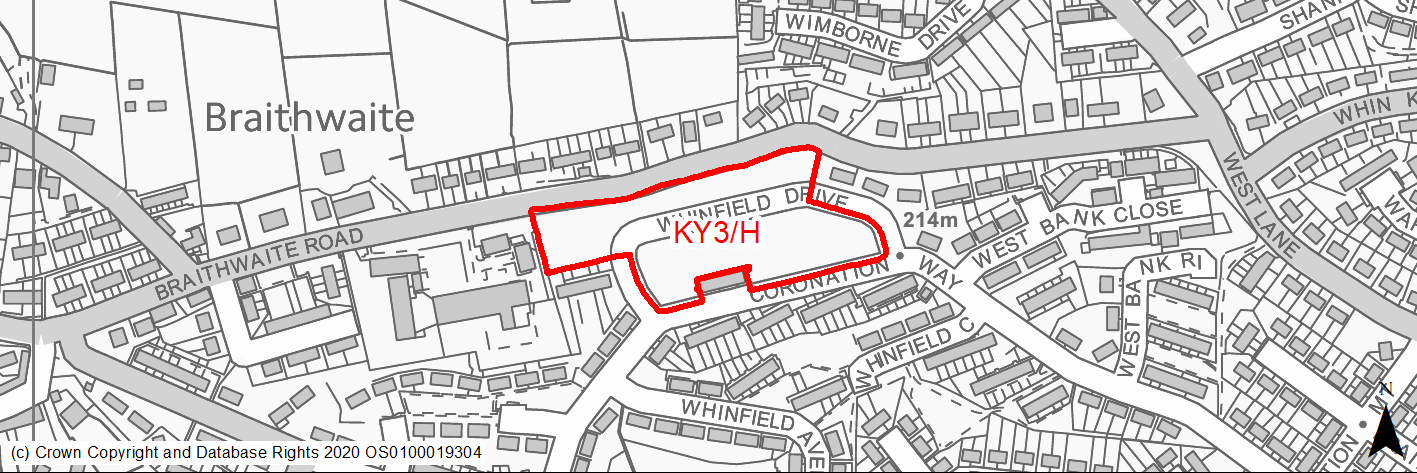
Site location
Principal Town - Keighley
Ward
Keighley West
Site description
The site consists of vacant grassland which was previously occupied by several blocks of local authority flats.
Proposed Allocation
Housing
SHLAA referencce
KY/012
Indicative no. dwellings
39
Site area (Gross) (ha)
1.24
Ownership
Council
Delivery timescales
Developable (6-10 years)
Type (PDL/Greenfield)
PDL
Green Belt
No
Flood Zone
Flood Zone 1
Potential site access
Access present from Whinfield Drive. Currently runs through centre of the site.
Public Transport Accessibility
Bus: The nearest bus stops are located at south western and south eastern corners of the site on Coronation Way. These offer four services per hour to/from Keighley Town Centre. Other bus stop are located to the north west on Braithwaite Road. These offer 1 service per hour to Keighley Bus Station (inbound) and Laycock (outbound). Services K1, K2 & K3.
Rail: Keighley railway station is located around 2km to the south east.
Sustainability Appraisal
This PDL site could be an efficient use of land, subject to effects on the MSA being ruled out. The site offers good access to key health facilities, employment areas, sustainable transport options (although the nearest railway station is 2.2km east), and particularly good access to schools. Residents may need to travel up to 2km east into the centre of Keighley to access a broader range of services and facilities, such as a supermarket, with only a limited number of small local shops and pubs in proximity to the site. The site falls within the South Pennine Moors SSSI/SPA/SAC Impact Risk Zones; thus, Natural England would need to be consulted to ensure no adverse effects on designated sites. The development of this site would be an opportunity to deliver biodiversity net gains. No significant adverse effects have been predicted.
Habitats Regulations Assessment
This site falls within 7km of the South Pennine Moors SPA/SAC. A HRA must be undertaken to ensure there are no significant effects on these protected sites. Developments within these zones must comply with Policy SP11; a SPD is being produced to provide further guidance.
Green Belt
N/A – Site not within the Green Belt.
Constraints and Opportunities
• This is a sloping, previously developed site located within the Keighley built up area.
• It was previously occupied by several blocks of flats (now demolished).
• It is well located in relation to local services and facilities, including a primary school, children's centre and a frequent public transport services.
• Access is available via the existing road network.
• It is within the 7km buffer of the SPA/SAC.
Development considerations
• Retention of existing mature trees around the site boundary.
• Retention of footpath through the site linking Whinfield Road and Braithwaite Road.
• Topography.
• Access is via the existing road network.
Conclusion/Summary
This is a previously developed site, sustainably located within the settlement boundary and close to a number of local services included a primary school and children's centres. It will deliver 39 dwellings.
(2) KY4/H - Braithwaite Avenue/North Dean Road
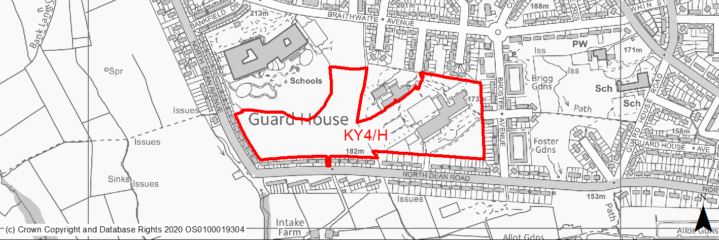
Site location
Principal Town - Keighley
Ward
Keighley West
Site description
The site consists of land that previously occupied by former primary school buildings and land. A new school has been built to the north west of the site, and this land is now surplus. The western part of site lies within a former phase 2 housing allocation in RUDP. The central and western parts are affected by various open space and playing field designations.
Proposed Allocation
Housing
SHLAA referencce
KY/015
Indicative no. dwellings
173
Site area (Gross) (ha)
5.25
Ownership
Council
Delivery timescales
Developable (6-15 years)
Type (PDL/Greenfield)
PDL
Green Belt
No
Flood Zone
Flood Zone 1
Potential site access
Potential site access via former school entrances on North Dean Road and School Road. Access may also be possible from the north via Braithwaite Grove and children's centre car park.
Public Transport Accessibility
Bus: The nearest bus stops area located to the 35m to north west on North Dean Avenue, 40m to the south on North Dean Avenue, and 40m to the east on Broster Avenue. These offer 4 services per hour towards Keighley Bus Station. Services K2 & K3.
Rail: Keighley railway station is located around 2km to the east.
Sustainability Appraisal
No significant adverse effects are predicted for KY/015. The site offers good access to employment areas, health facilities, sustainable transport options (although the nearest railway station is 2.2km east), and excellent access to schools. The site could be an opportunity to deliver biodiversity net gains and improvements to the local character, depending on the implementation of development. Depending on the layout of development, in relation to the distribution of PDL and greenfield within the site, it could be an efficient use of land.
Habitats Regulations Assessment
This site falls within 7km of the South Pennine Moors SPA/SAC. A HRA must be undertaken to ensure there are no significant effects on these protected sites. Developments within these zones must comply with Policy SP11; a SPD is being produced to provide further guidance.
Green Belt
N/A – Site not within the Green Belt.
Constraints and Opportunities
• This is a mainly previously developed site located within the Keighley built up area. It was previously occupied a school and its associated playground, playing fields and car parking areas. It offers the opportunity to regenerate a large site within an established residential area.
• It is well located for existing local services including shops, primary school, children's centre and public transport.
• Part of the site is a designated as a playing field, whilst there are potential drainage issues on the western section.
• Appropriate access points will need to be determine, whilst a public right of way runs through the south eastern corner.
• It is within the 7km buffer of the SPA/SAC.
Development considerations
• This is a mainly previously developed site located within the Keighley built up area. It was previously occupied a school and its associated playground, playing fields and car parking areas. It offers the opportunity to regenerate a large site within an established residential area.
• It is well located for existing local services including shops, primary school, children's centre and public transport.
• Part of the site is a designated as a playing field, whilst there are potential drainage issues on the western section.
• Appropriate access points will need to be determine, whilst a public right of way runs through the south eastern corner.
• It is within the 7km buffer of the SPA/SAC.
Conclusion/Summary
This is a previously developed site, sustainably located within the settlement boundary and close to a number of local services included a primary school and childrens centres. It will deliver 173 dwellings.
(3) KY5/H - North Dean Road
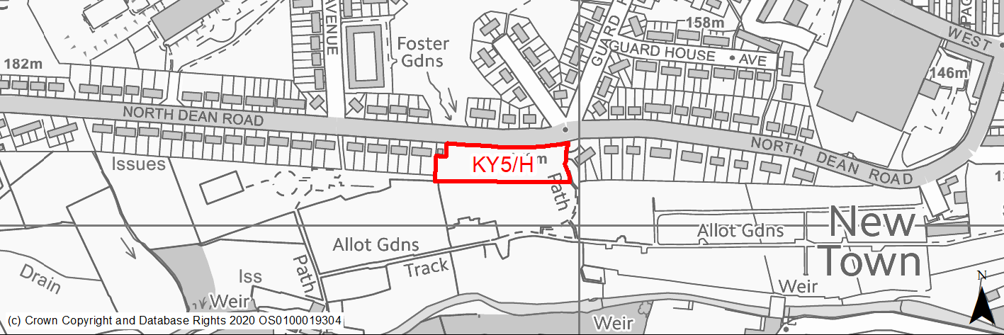
Site location
Principal Town - Keighley
Ward
Keighley West
Site description
The site consists of an area of open space.
Proposed Allocation
Housing
SHLAA referencce
KY/017
Indicative no. dwellings
12
Site area (Gross) (ha)
0.34
Ownership
Council
Delivery timescales
Developable (6-10 years)
Type (PDL/Greenfield)
Greenfield
Green Belt
No
Flood Zone
Flood Zone 1
Potential site access
From North Dean Road.
Public Transport Accessibility
Bus: The bearest bus stops are located on North Dean Road (circa 30m to the east and 55m to the west of the site). These stops provide two services per hour towards Keighley (inbound) and two services per to Guard House (outbound). Service K2.
Rail: Keighley railway station is located around 2km to the east.
Sustainability Appraisal
No significant adverse effects have been predicted for this site. As a small greenfield location, there could potentially be minor adverse effects on natural environment themed objectives, although depending on the implementation of development there could be an opportunity for biodiversity net gains and improvements to the local character.
The site offers good access to employment areas, health facilities, sustainable transport options (although the nearest railway station is 2km east), and excellent access to schools.
Habitats Regulations Assessment
This site falls within 7km of the South Pennine Moors SPA/SAC. A HRA must be undertaken to ensure there are no significant effects on these protected sites. Developments within these zones must comply with Policy SP11; a SPD is being produced to provide further guidance.
Green Belt
N/A – Site not within the Green Belt.
Constraints and Opportunities
• This is a greenfield site located within the Keighley built up area. It is currently used as informal public open space and is within a Green Infrastructure corridor.
• A public right of way runs through eastern edge, whilst a stream is culverted underground within the site.
• An electricity sub-station and transmission line is within the western boundary.
• It is within the 7km buffer of the SPA/SAC.
Development considerations
• Mitigate any landscape impacts through appropriate layout and design.
• Ensure the retention of the public right of way in any layout in order to link to neighbouring areas.
• Address and mitigate the loss of the informal open space.
• Investigate opportunities to improve public transport accessibility.
• Ensure sufficient clearances for the sub-station.
• Investigate opportunities for biodiversity enhancement.
Conclusion/Summary
This is a sustainable site within the settlement boundary, close to existing local services and facilities including schools and shops. It will deliver 12 dwellings.
(2) KY6/H - Holme Mill Lane
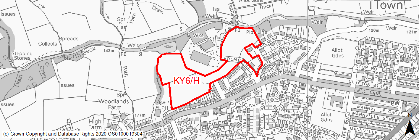
Site location
Principal Town - Keighley
Ward
Keighley West
Site description
The site consists of areas grazing land as well as a number of heavily wooded areas.
Proposed Allocation
Housing
SHLAA referencce
KY/019
Indicative no. dwellings
102
Site area (Gross) (ha)
3.17
Ownership
Private
Delivery timescales
Deliverable (1-5 years), Developable (6-10 years)
Type (PDL/Greenfield)
Greenfield
Green Belt
No
Flood Zone
Flood Zone 1 (97%), Flood Zone 2 (1.5%) & Flood Zone 3 (1.5%)
Potential site access
Site access from Holme Mill Lane.
Public Transport Accessibility
Bus: The nearest bus stops are located on Fell Lane (circa 70m to the south east of the site). These stops provide 2 services per hour towards Keighley Bus Station (inbound) and Exley Head (outbound). Service K6.
Rail: Keighley railway station is located around 1.8km to the north east.
Sustainability Appraisal
The site coincides with a former landfill and so any planning application here would need to be supported by the relevant studies. No significant adverse effects have been predicted for the site although, as a predominantly greenfield site, minor adverse effects have been predicted for most natural environment themed SA Objectives. The site includes woodland, some of which is TPO protected, and so avoiding adverse effects on the local character, as well as the local ecological network, would be difficult.
The site offers good access to employment areas, health facilities, sustainable transport options (although the nearest railway station is 2km east), and excellent access to schools.
Habitats Regulations Assessment
This site falls within 7km of the South Pennine Moors SPA/SAC. A HRA must be undertaken to ensure there are no significant effects on these protected sites. Developments within these zones must comply with Policy SP11; a SPD is being produced to provide further guidance.
Green Belt
N/A – Site not within the Green Belt.
Constraints and Opportunities
• This is a greenfield site within the Keighley built up area, adjacent to residential and employment uses as well as the North Beck valley.
• It is also within a Green Infrastructure corridor and contains and is ajdacent to a Local Wildlife Site and a range of habitats.
• TPOs are present within the eastern section.
• It is within the 7km buffer of the SPA/SAC.
• The site was the subject of an outline planning application for residential development, residential care home and replacement scout hut. Following refusal, it was allowed on appeal in April 2020.
Development considerations
• Key development considerations have been addressed as part of the planning application and appeal process. Details of appearance, landscaping and layout will be addressed through a Reserved Matters application (to be submitted no later than 3 years from the date of the outline planning permission - by 16.04.2023), whilst other matters are dealt with via conditions attached to the permission.
Conclusion/Summary
This site benefits from outline planning permission for residential development, a residential care home and scout hut. Details of appearance, landscaping and layout will be addressed through a Reserved Matters application (to be submitted no later than 3 years from the date of the outline planning permission - by 16.04.2023), whilst other matters are dealt with via conditions attached to the permission. It is expected to deliver 102 dwellings.
(20) KY7/H - Wheathead Lane
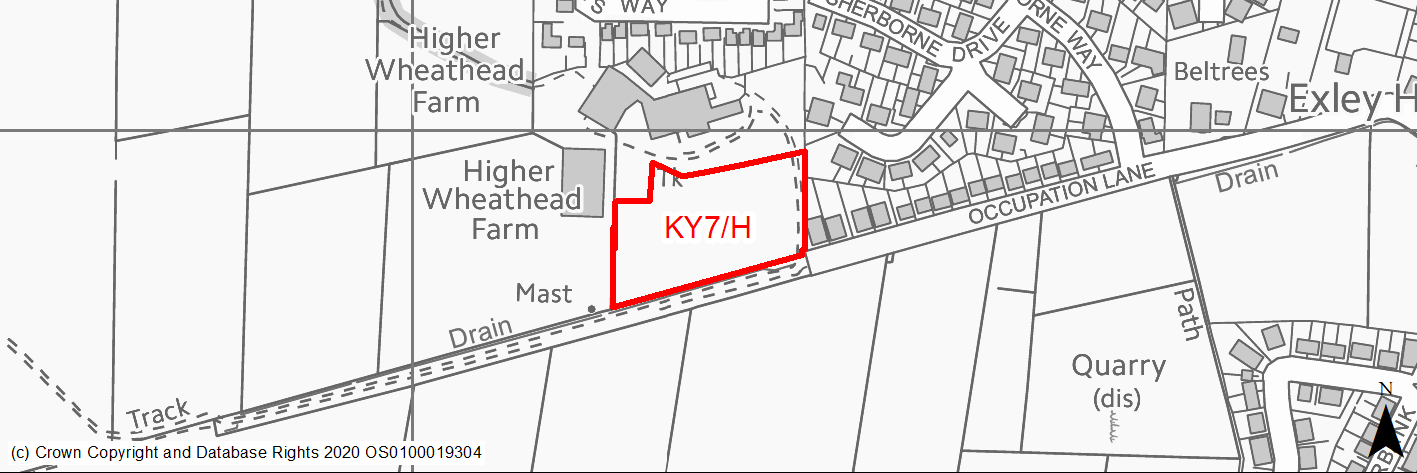
Site location
Principal Town - Keighley
Ward
Keighley West
Site description
The site consists of an agricultural field adjacent to High Wheatheard Farm.
Proposed Allocation
Housing
SHLAA referencce
KY/021b
Indicative no. dwellings
22
Site area (Gross) (ha)
0.84
Ownership
Private
Delivery timescales
Developable (6-10 years)
Type (PDL/Greenfield)
Greenfield
Green Belt
Yes
Flood Zone
Flood Zone 1
Potential site access
Site already has an agricultural access route running from Wheathead Lane via the farm complex. Alternative access is available from Occupation Lane.
Public Transport Accessibility
Bus: The nearest bus stop is located around 200m to the north east of the site on Wheathead Lane. This provides 2 services per hour to Keighley Bus Station (Service K6). Other stops are available around 420m to the south east on Keighley Road. These offer 3 (occasionally 4) services per hour to Keighley Bus Station (inbound) and Oakworth (outbound). There is also more limited service from Keighley to Braithwaite (two hourly). Services K7 & K16.
Rail: Keighley railway station is located around 2.8km to the north east.
Sustainability Appraisal
The site could deliver a major positive effect for residents on the education SA Objective as a result of being within the target distance for both primary and secondary education facilities.
Minor positive effects were predicted for most socio-economic themed SA Objectives due to the benefits of new residential development for the local economy as well as the location of the site in relation to transport links and health facilities.
No significant adverse effects have been predicted for the site, but minor adverse effects were predicted for a range of natural environment themed SA Objectives, primarily as a result of the impacts of new development on a 100% greenfield and Green Belt site.
Habitats Regulations Assessment
This site falls within 7km of the South Pennine Moors SPA/SAC. A HRA must be undertaken to ensure there are no significant effects on these protected sites. Developments within these zones must comply with Policy SP11; a SPD is being produced to provide further guidance.
Green Belt
See individual Green Belt site assessment in the accompanying report.
Constraints and Opportunities
• This is a gently sloping, greenfield site within the Green Belt, adjacent to the settlement boundary for Keighley. It is an agricultural field bounded by fencing and dry stone walling, a farm complex and residential development is to the north and east respectively.
• Located in a prominent position close to a hill top, therefore potential for landscape impacts.
• Some areas of surface water flooding are present.
• Within 7km buffer of the SPA/SAC.
Development considerations
• Provision of compensatory improvements to the surrounding Green Belt required.
• Sensitive design and layout should ensure that landscape/visual impacts are mitigated through the use of appropriate building heights and appropriate screening.
• Most appropriate access point to further investigated.
Conclusion/Summary
This site is a sustainably located Green Belt site adjoining the settlement boundary for Keighley. It will deliver an estimated 22 dwellings, but will require sensitive design to ensure that landscape impacts are addressed.
(16) KY8/H - Higher Wheathead Farm
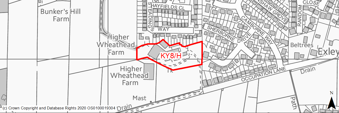
Site location
Principal Town - Keighley
Ward
Keighley West
Site description
The consists of a number of agricultural buildings which are used by feed merchant company.
Proposed Allocation
Housing
SHLAA referencce
KY/022
Indicative no. dwellings
29
Site area (Gross) (ha)
0.92
Ownership
Private
Delivery timescales
Developable (6-10 years)
Type (PDL/Greenfield)
Greenfield
Green Belt
No
Flood Zone
Flood Zone 1
Potential site access
Access could be from Occupation Lane.
Public Transport Accessibility
Bus: The nearest bus stop is located around 170m to the north of the site on Wheathead Lane. This provides 2 services per hour to Keighley Bus Station. Service K6. Other stops are available around 460m & 470m to the south east on Keighley Road. These provide 3 services per hour to Keighley Bus Station (inbound) and Oakworth (outbound). Service K7.
Rail: Keighley railway station is located around 2.7km to the north east.
Sustainability Appraisal
Development at this site would be unlikely to result in a significant effect, either positive or negative, on any SA Objective.
As a PDL site, there are opportunities here for achieving biodiversity net gains and improvements to the local character, depending on the implementation of the development.
Minor positive effects were also predicted for a range socio-economic themed SA Objectives due to the benefits of new residential development for the local economy as well as the location of the site in relation to transport links and health and education facilities.
Habitats Regulations Assessment
This site falls within 7km of the South Pennine Moors SPA/SAC. A HRA must be undertaken to ensure there are no significant effects on these protected sites. Developments within these zones must comply with Policy SP11; a SPD is being produced to provide further guidance.
Green Belt
N/A – Site not within the Green Belt.
Constraints and Opportunities
• This is a greenfield site within the settlement boundary for Keighley, on the western edge of the town. It is currently occupied by a farm complex and agricultural feed business. Residential development is to the north and east.
• Located in a prominent position close to a hill top, therefore potential for landscape impacts.
• Some areas of surface water flooding are present.
• Access available from Occupation Lane.
• Within 7km buffer of the SPA/SAC.
Development considerations
• Design and layout should ensure that landscape impacts are mitigated.
• Mitigate any surface water flooding and drainage issues.
• Most appropriate access point to further investigated.
• Opportunities for improved pedestrian and cycling linkages should be investigated.
Conclusion/Summary
This site is located within the settlement boundary for Keighley. It will deliver an estimated 29 dwellings, but will require sensitive design to ensure that landscape impacts are addressed.
(4) KY9/H - Former Bronte School Playing Fields, Keighley Road
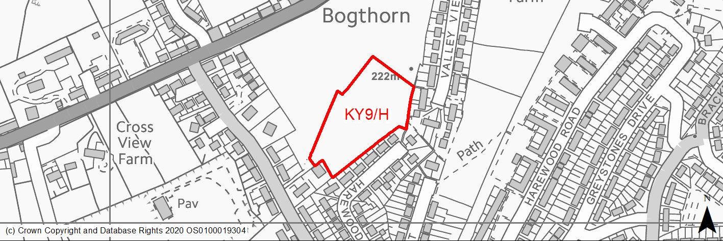
Site location
Principal Town - Keighley
Ward
Keighley West
Site description
The site consists of the former playing fields, attached to the former Bronte School. These are no longer in use and from a potential second phase for the adjacent housing development.
Proposed Allocation
Housing
SHLAA referencce
KY/024B
Indicative no. dwellings
41
Site area (Gross) (ha)
1
Ownership
Council
Delivery timescales
Developable (6-10 years)
Type (PDL/Greenfield)
Greenfield
Green Belt
No
Flood Zone
Flood Zone 1
Potential site access
Access is available from Keighley Road via Hareton Way. The latter serves the first phase of the site.
Public Transport Accessibility
Bus: The nearest bus stops are located 140m & 160m to the north-east of the site on Keighley Road. These offer 3 (occasionally 4) services per hour towards Keighley Bus Station (inbound) and Oakworth (outbound), Service K7.
Rail: Keighley railway station is located around 3km to the north east.
Sustainability Appraisal
No significant adverse effects have been predicted for this site. The site generally has good access to services and facilities, including those for sustainable transport options, jobs, schools, and health facilities. The site is greenfield and contains TPO protected woodland, although the site appears to be predominantly vacant and contains no other GI or biodiversity elements and so the scope for minor adverse effects on natural environment themed SA Objectives is somewhat limited.
Habitats Regulations Assessment
This site falls within 7km of the South Pennine Moors SPA/SAC. A HRA must be undertaken to ensure there are no significant effects on these protected sites. Developments within these zones must comply with Policy SP11; a SPD is being produced to provide further guidance.
Green Belt
N/A – Site not within the Green Belt.
Constraints and Opportunities
• This is a greenfield site within the Keighley built up area. It previously formed part of the former Bronte School and it associated playing fields, which have since been demolished. Parts of the former school site has been developed for residential purposes and a care home. The site is remaining portion of the former school site and would form a second phase of residential development.
Development considerations
• Address existing playing field designation.
• Appropriate open space should be provided within the site.
• Connections to the wider public rights of way network should be provided.
Conclusion/Summary
This is a sustainable site within the existing built up area of Keighley, close to existing services and facilities. It will deliver an estimated 41 dwellings and form a second phase to the existing development.
(28) KY10/H - Exley Road/Oakworth Road, Keighley Road
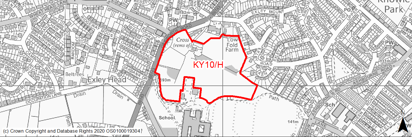
Site location
Principal Town - Keighley
Ward
Keighley West
Site description
The consists of a number of uneven greenfields currently used for cattle grazing. It also includes a single dwelling and several dry stone walls within the boundary. Part of the site is used as a car park for adjacent school.
Proposed Allocation
Housing
SHLAA referencce
KY/025
Indicative no. dwellings
125
Site area (Gross) (ha)
5.19
Ownership
Council
Delivery timescales
Developable (6-15 years)
Type (PDL/Greenfield)
Greenfield
Green Belt
No
Flood Zone
Flood Zone 1
Potential site access
Potential access via existing private road to dwelling, although would suggest a more suitable access would be required.
Public Transport Accessibility
Bus: The nearest bus stops are located on Oakworth Road (circa 20m & 45m) to the north of the site. These offer 4 (occasionally 3) services per hour towards Keighley Bus Station (inbound) and 3 services per hour towards Oakworth (Outbound). Service K7 & K16.
Rail: Keighley railway station is located around 2km to the north west.
Sustainability Appraisal
The site could deliver major positive effects for residents on both the health and education SA Objectives, as a result of being within the target distances for all necessary health facilities and centres for primary and secondary education.
Minor positive effects were predicted for remaining socio-economic themed SA Objectives due to the benefits of new residential development for the local economy as well as the location of the site in relation to transport links, local amenities and employment areas.
No major adverse effects have been predicted for the site, but minor adverse effects were predicted for a range of natural environment themed SA Objectives, primarily as a result of the impacts of new development on a greenfield site which contains TPO woodland and trees and deciduous woodland priority habitat.
Habitats Regulations Assessment
This site falls within 7km of the South Pennine Moors SPA/SAC. A HRA must be undertaken to ensure there are no significant effects on these protected sites. Developments within these zones must comply with Policy SP11; a SPD is being produced to provide further guidance.
Green Belt
N/A – Site is not within the Green Belt.
Constraints and Opportunities
• This is a greenfield site within the Keighley built up area, consisting of several fields used for grazing. It is close to local facilities and services including a schools and public transport.
• An opportunity exists top open up the enclosed footpath along the eastern boundary.
• Access can be obtained from surrouding highway network.
• There are a number of TPO woodland areas present as well as a number of areas of priority habitat.
• A Grade II Listed Building is within the western boundary of the site.
• It is within the 7km buffer of the SPA/SAC.
Development considerations
• Ecology survey will be required to assess and mitigate potential impacts on prioritiy habitats.
• Heritage assessment will be required to assess and mitigate impact on Listed Building.
• Mitigate any landscape imapcts through appropriate layout and design including retention existing mature trees and key views as well as provision of appropriate open space.
Conclusion/Summary
This is a sustainable site within the existing built up area of Keighley, with good access to local services and facilities include schools, shops and health facilities, as well as public transport. Development will need to ensure key features of the site are retained within any design and layout, with appropriate mitigation to address potential impacts. It will deliver an estimated 125 dwellings.
(1) KY11/H - Former Devonshire Mill, West Lane
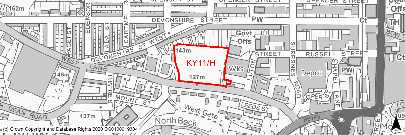
Site location
Principal Town - Keighley
Ward
Keighley Central
Site description
The site consists of former mill site (Devonshire Mill), which has been cleared and awaiting redevelopment. It previously benefitted from planning permission for residential development.
Proposed Allocation
Housing
SHLAA referencce
KY/027
Indicative no. dwellings
48
Site area (Gross) (ha)
0.93
Ownership
Private
Delivery timescales
Developable (6-10 years)
Type (PDL/Greenfield)
PDL
Green Belt
No
Flood Zone
Flood Zone 1
Potential site access
Site access point is on West Lane, at south east corner of the site.
Public Transport Accessibility
Bus: The nearest bus stops are located of West Lane to west (140m & 160m) and east (155m & 160m) of site with 4/5 services per hour towards Keighley Bus Station (inbound) and towards Guard House (outbound). Services K2, K3 & K16.
Rail: Keighley railway station is located around 860m (in a straight line)/1km (via quickest walking route) (13 mins) to the north east. This offers 4 services per hour towards Bradford & Leeds (2 services per hour to each) and Skipton. Also has other limited services to Carlisle and Lancaster/Morecambe.
Sustainability Appraisal
Site is 100% PDL, constituting an efficient use of land, and provides residents with excellent access to education and health facilities, as well as employment and economic areas and the wide array of services and facilities on offer in the centre of Keighley. Site is a good opportunity to achieve improvements to local ecological connectivity as well as townscape character. The only adverse effects predicted for the site are minor and related to increase in air pollution and water consumption (which has been predicted at nearly all sites).
Habitats Regulations Assessment
This site falls within 7km of the South Pennine Moors SPA/SAC. A HRA must be undertaken to ensure there are no significant effects on these protected sites. Developments within these zones must comply with Policy SP11; a SPD is being produced to provide further guidance.
Green Belt
N/A – Site not within the Green Belt.
Constraints and Opportunities
• This is a previously developed vacant site close to the centre of Keighley. It was occupied by a mill building, which was demolished. It is within walking distance of local services and facilities including health services as well as those in the town centre.
• Due to it former industrial use land contamination may be an issue, whilst an appropriate access will be required.
• It is within the 7km buffer of the SPA/SAC.
Development considerations
• Contaminated land assessment will be required to identify and mitigate any potential issues.
• Seek, where possible, through design and layout to improve ecological connections.
• Determine the most appropriate access from West Lane.
Conclusion/Summary
This is a sustainble site within the existing built up area of Keighley, within good access to local services as well as the town centre. It represents an opportunity bring a previously developed site back into beneficial use. It will deliver an estimated 48 dwellings.
(28) KY12/H - Keighley Road, Exley Head
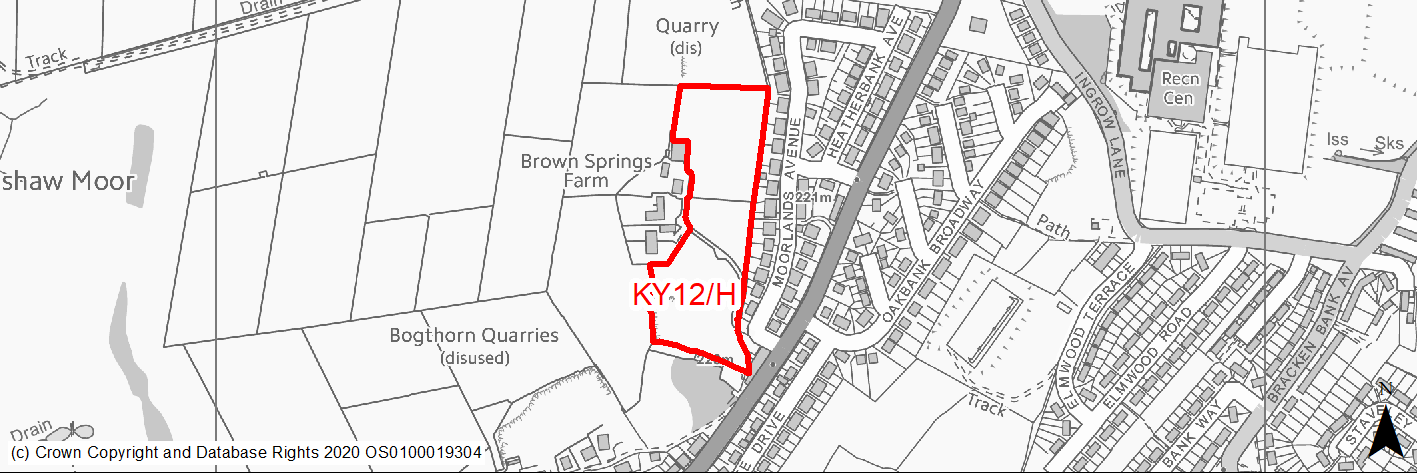
Site location
Principal Town - Keighley
Ward
Keighley West
Site description
The site consists of several agricultural fields and a former quarry.
Proposed Allocation
Housing
SHLAA referencce
KY/029a
Indicative no. dwellings
61
Site area (Gross) (ha)
1.94
Ownership
Private
Delivery timescales
Developable (6-15 years)
Type (PDL/Greenfield)
Greenfield
Green Belt
No
Flood Zone
Flood Zone 1
Potential site access
SHLAA considers that the site could be accessed via three points from Keighley Road. However, the Delivery Questionnaire considers access to the a constraint to development. There is also an issue about joining both sections together as this may require additional land. Northern Section: Potential for access from Keighley Road via Moorland Avenue and existing access to the Brown Springs Farm complex.
Public Transport Accessibility
Bus: The nearest bus stops are located around 160m & 170m to the north east and 30m & 50m to the east on Keighley Road. These offer 3 (occasionally 4) services per hour to Keighley Bus Station (inbound) and Oakworth (outbound). There is also more limited service from Keighley to Braithwaite (two hourly). Services K7 & K16.
Rail: Keighley railway station is located around 2.6km to the north east.
Sustainability Appraisal
As a large greenfield site containing GI elements, development here would be likely to have minor adverse effects on most natural environment themed SA Objectives. However, no significant adverse effects have been predicted. The site would provide residents with good access to most services and facilities, including public transport options, jobs, economic areas and cultural/recreational areas, as well as excellent access to schools and health facilities.
Habitats Regulations Assessment
This site falls within 7km of the South Pennine Moors SPA/SAC. A HRA must be undertaken to ensure there are no significant effects on these protected sites. Developments within these zones must comply with Policy SP11; a SPD is being produced to provide further guidance.
Green Belt
N/A – Site not within the Green Belt.
Constraints and Opportunities
• This is a gently sloping, greenfield site within the settlement boundary for Keighley, on the south western edge of the built up area.
• Due to its location prominent location on the edge of the settlement, there is will be landscape and visual impacts, whilst a public right of way crosses the site.
• Settlement coalesence is also a consideration.
• It is adjacent to a designated village green and includes part of a former quarry.
• It is within the 7km buffer of the SPA/SAC.
Development considerations
• Sensitive design and layout will be required to mitigate landscape and visual impacts including through the use appropriate building heights and screening.
• Impacts of adjacent residential properties should be mititgated.
• Public right of way should be safeguarded.
• Access is available from Keighley Road, however further investigation is required.
Conclusion/Summary
This is a sustainable site within the settlement boundary for Keighley with good access to local services and facilities including primary and secondary schools and medical centres. It is also adjacent to a public transport corridor with frequent services. It will deliver an estimated 61 dwellings.
(23) KY13/H - Keighley Road, Exley Head
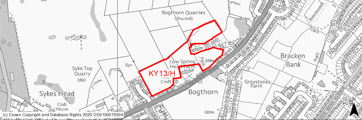
Site location
Principal Town - Keighley
Ward
Keighley West
Site description
The site consists of several agricultural fields and a former quarry.
Proposed Allocation
Housing
SHLAA referencce
KY/029b
Indicative no. dwellings
80
Site area (Gross) (ha)
3.06
Ownership
Private
Delivery timescales
Developable (6-15 years)
Type (PDL/Greenfield)
Greenfield
Green Belt
No
Flood Zone
Flood Zone 1
Potential site access
SHLAA considers that the site could be accessed via three points from Keighley Road. However, the Delivery Questionnaire considers access to the a constraint to development. There is also an issue about joining both sections together as this may require additional land. Southern section: potential for access in two locations. The first is via track leading to Higher Spring Farm. However, this is narrow with little room for expansion. The second is via an existing field access from Thornhill Avenue.
Public Transport Accessibility
Bus: The nearest bus stops are located around 20m to the south and 25m to the south west on Keighley Road. These offer 3 (occasionally 4) services per hour to Keighley Bus Station (inbound) and Oakworth (outbound). There is also more limited service from Keighley to Braithwaite (two hourly). Services K7 & K16
Rail: Keighley railway station is located around 2.8km to the north east.
Sustainability Appraisal
As a large greenfield site containing GI elements, development here would be likely to have minor adverse effects on most natural environment themed SA Objectives. It is unclear if the farm buildings within the site would be retained, or if they could be reused. No significant adverse effects have been predicted. The site would provide residents with good access to most services and facilities, including public transport options, jobs, economic areas and cultural/recreational areas, as well as excellent access to schools and health facilities.
Habitats Regulations Assessment
This site falls within 7km of the South Pennine Moors SPA/SAC. A HRA must be undertaken to ensure there are no significant effects on these protected sites. Developments within these zones must comply with Policy SP11; a SPD is being produced to provide further guidance.
Green Belt
N/A – Site not within the Green Belt.
Constraints and Opportunities
• This a greenfield site within the settlement boundary for Keighley, on the south western edge of the built up area. It has a mixture of gentle and steeply sloping topography as well as an area of more level land (a former quarry).
• Due to its location prominent location on the edge of the settlement, there is will be landscape and visual impacts.
• Settlement coalesence is also a consideration.
• It is adjacent to a designated village green and includes part of a former quarry.
• It is within the 7km buffer of the SPA/SAC.
Development considerations
• Sensitive design and layout will be required to mitigate landscape and visual impacts including through the use appropriate building heights and screening.
• Impacts of adjacent residential properties should be mititgated.
• Public right of way should be safeguarded.
• Access is available via a field access from Thornhill Road, however further investigations are required to identify the most appropriate access point.
Conclusion/Summary
This is a sustainable site within the settlement boundary for Keighley withigood access to local services and facilities including primary and secondary schools and medical centres. It is also adjacent to a public transport corridor with frequent services. It will deliver an estimated 80 dwellings.
(11) KY14/H - Bradford Road, Riddlesden
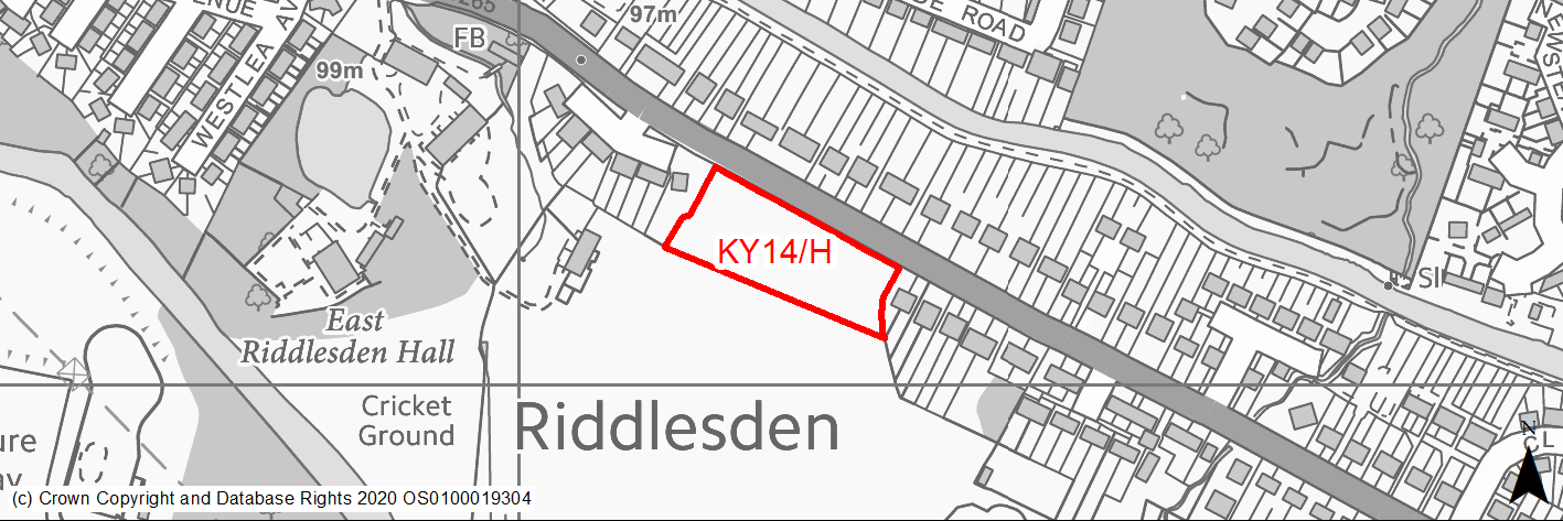
Site location
Principal Town - Keighley
Ward
Keighley East
Site description
The site consists of an area of open land used for grazing animals.
Proposed Allocation
Housing
SHLAA referencce
KY/043
Indicative no. dwellings
22
Site area (Gross) (ha)
0.7
Ownership
Private
Delivery timescales
Developable (6-10 years)
Type (PDL/Greenfield)
Greenfield
Green Belt
No
Flood Zone
Flood Zone 1 (81.4%), Flood Zone 2 (18.6%), Flood Zone 3a (0.14%)
Potential site access
Existing access from Bradford Road to Airedale Cricket Club is located at the north east corner of the site.
Public Transport Accessibility
Bus: The nearest bus stops are located on Bradford Road. One immediately adjoins the northern edge of the site whilst the other is circa 80m to the east. These provide 7 services per hour towards Keighley and 8 services per hour towards Bradford (7 per hour) and Cullingworth (hourly). Services 662, K17 & K19.
Rail: Keighley railway station is located around 1.7km to the south west.
Sustainability Appraisal
Development at this site would be unlikely to result in a significant effect, either positive or negative, on any SA Objective.
Minor positive effects were predicted for a range socio-economic themed SA Objectives due to the benefits of new residential development for the local economy as well as the location of the site in relation to transport links, local amenities, health facilities and employment areas. However, access to both primary and secondary schools is somewhat limited due to distance.
No major adverse effects have been predicted for the site, but minor adverse effects were predicted for a range of natural environment themed SA Objectives, primarily as a result of the impacts of new development on a 100% greenfield site.
The Leeds Liverpool Canal Conservation Area is 60m north-east of site meaning careful consideration around protecting water quality would be required, and there are two Grade I Listed Buildings in proximity to the site, the setting of which could potentially be impacted upon.
Habitats Regulations Assessment
This site falls within 2.5km of the South Pennine Moors SPA/SAC a HRA must be undertaken to ensure there are no significant effects on these protected sites in terms of impact on supporting habitat which might be functionally linked to the SPA and recreational pressures. Developments within these zones must comply with Policy SP11; an SPD is being produced to provide further guidance.
Green Belt
N/A – Site not within the Green Belt.
Constraints and Opportunities
• This is a greenfield site within the settlement boundary for Keighley (Riddlesden), which is currently used for animal grazing. It is at lower level that adjoining road and slopes steeply from it. It is a gap between residenital development.
• There is potential to impact on views of the Aire Valley, whilst it is in close proximity to East Riddlesden Hall and its grounds.
• Part of the site is with Flood Zone 2.
• It is within a Green Infrastructure corridor as well as the 2.5km buffer of the SPA/SAC.
Development considerations
• Sensitive design and layout is required to ensure that development is of an appropriate scale and density for it surroundings and reflect the close proximity of East Riddlesden Hall and grounds.
• Surface water flooding and drainage issues will require mitigation.
• Bird survey will required.
• Access can be obtained from Bradford Road.
Conclusion/Summary
This is a sustainable site within the settlement boundary for Keighley with good access to local services and facilities including primary school and shops. It is also adjacent to a public transport corridor with very frequent services. It will deliver an estimated 22 dwellings.
(38) KY15/H - Carr Bank, Riddlesden
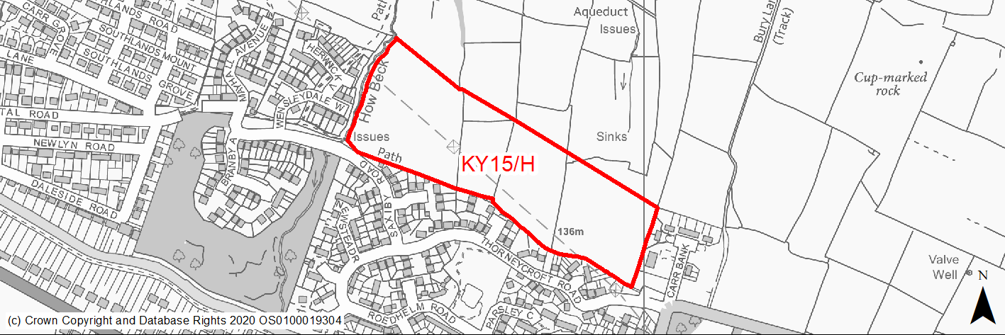
Site location
Principal Town - Keighley
Ward
Keighley East
Site description
The site consists of several sloping and undulating agricultural located north, east and west of existing residential areas. The fields are divided by drystone walls. The site is crossed by an electricity transmission line.
Proposed Allocation
Housing
SHLAA referencce
KY/046
Indicative no. dwellings
139
Site area (Gross) (ha)
6.84
Ownership
Private
Delivery timescales
Developable (6-15 years)
Type (PDL/Greenfield)
Greenfield
Green Belt
Yes
Flood Zone
Flood Zone 1
Potential site access
Strip of land has been left to allow potential access from Thorneycroft Road, whilst there is a further potential access point from Saxilby Road.
Public Transport Accessibility
Bus: The nearest bus stop is located around 100m to the south east of the site on Carr Bank Lane. This provides an hourly service to Cullingworth (eastbound) and Keighley (westbound) (Services K17 & K19). Other stops are located around 400m to the south on Bradford Road. These provide between 6 & 8 services per hour towards Bradford (6 per hour) and Cullingworth (1/2 per hour) (eastbound) and Keighley Bus Station (westbound) (Services 662, K17 & K19).
Rail: Keighley railway station is located around 2.3km to the south west, whilst Crossflatts railway station is also 2.3km to the south east.
Sustainability Appraisal
Development at this site would be unlikely to result in a significant effect, either positive or negative, on any SA Objective.
Minor positive effects were predicted for a range socio-economic themed SA Objectives due to the benefits of new residential development for the local economy as well as the location of the site in relation to transport links, local amenities, health facilities and employment areas. However, access to both primary and secondary schools is somewhat limited due to distance.
No major adverse effects have been predicted for the site, but minor adverse effects were predicted for a range of natural environment themed SA Objectives, primarily as a result of the impacts of new development on a 100% greenfield site.
Habitats Regulations Assessment
This site falls within 2.5km of the South Pennine Moors SPA/SAC a HRA must be undertaken to ensure there are no significant effects on these protected sites in terms of impact on supporting habitat which might be functionally linked to the SPA and recreational pressures. Developments within these zones must comply with Policy SP11; an SPD is being produced to provide further guidance.
Green Belt
Based on planning judgement the site has a moderate potential impact on the Green Belt.
• The site is located in major Green Belt parcel.
• The site makes a moderate contribution to the purposes of including land in the Green Belt.
• The site has a major potential for sprawl and would have a moderate impact on openness.
• There is no opportunity to create a stronger Green Belt boundary than the existing boundary.
Constraints and Opportunities
• This is a large greenfield site within the Green Belt, adjacent to the settlement boundary for Keighley (Riddlesden). The site specific Green Belt assessment indicates that it has a moderate potential impact.
• It is a sloping as well as undulating site, whilst there are landscaping and visual impacts. In additional, archaeological features and a Scheduled Monument affect the site.
• A high voltage electricity transmission line crosses the site.
• It is located within a Green Infrastructure corridor and within the 2.5km buffer of the SPA/SPA.
Development considerations
• Provision of compensatory improvements to the surrounding Green Belt.
• A landscape and visual impact assessment will be required to identify and mitigate any impacts through sensitive design and layout.
• Layout will also need to reflect appropriate distances for development around high voltage electricity transmission lines.
• Heritage/archaeology assessment will be required to determine impacts on heritage/archaeological assets.
• Ecological survey and bird survey will be required.
• Flood risk assessment required (site over 1ha).
• Access available from adjacent road network (Saxilby Road), but most suitable point should be investigated.
Conclusion/Summary
This is a sustainably located Green Belt site adjoining the settlement boundary, which would deliver an estimated 139 dwellings, but will need a sensitive design and layout to mitigate the landscape impact and to address the presence of the high voltage transmission line.
(17) KY16/H - Carr Bank, Riddlesden
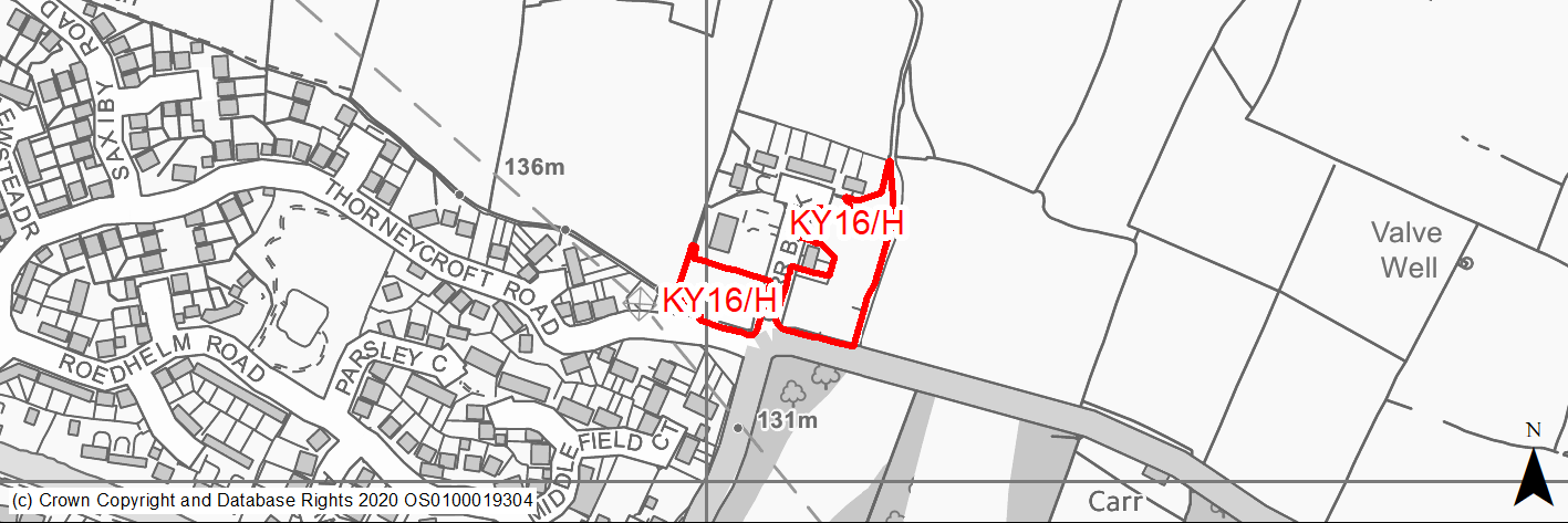
Site location
Principal Town - Keighley
Ward
Keighley East
Site description
The site consists of open land that was formerly occupied by local authority housing.
Proposed Allocation
Housing
SHLAA referencce
KY/047
Indicative no. dwellings
16
Site area (Gross) (ha)
0.49
Ownership
Council
Delivery timescales
Developable (6-10 years)
Type (PDL/Greenfield)
PDL
Green Belt
No
Flood Zone
Flood Zone 1
Potential site access
Site can be accessed via existing cul de sac (Carr Bank).
Public Transport Accessibility
Bus: The nearest bus stops are located on both sides of Carr Lane adjacent to the south east corner of the site with hourly service towards Keighley (inbound) and Cullingworth (outbound). Services K17 & K19 Other stops available on Bradford Road circa 450m/500m to the south of the site, with frequent services to Keighley and Bradford. Service 662.
Rail: Crossflatts railway station is located 2.2km to the south east, whilst Keighley railway station is (2.6km to south west).
Sustainability Appraisal
No significant adverse effects have been predicted at the site. As a PDL site situated away from sensitive designations, the scope for adverse effects on natural environment themed SA Objectives is limited. The site is well situated for providing access to services, schools, jobs, health facilities and cultural places, although no significant positive effects have been predicted for any of the socio-economic themed SA Objectives.
Habitats Regulations Assessment
This site falls within 2.5km of the South Pennine Moors SPA/SAC a HRA must be undertaken to ensure there are no significant effects on these protected sites in terms of impact on supporting habitat which might be functionally linked to the SPA and recreational pressures. Developments within these zones must comply with Policy SP11; an SPD is being produced to provide further guidance.
Green Belt
N/A – Site not within the Green Belt.
Constraints and Opportunities
• This is a previously developed site within an existing residential area within the settlement boundary of Keighley (Riddlesden). It was previously occupied by a number of dwellings (post war pre-fabricated homes).
• Access is available via Carr Bank.
• A major electricity transmission line is located close to the southern edge of site.
• Within 2.5km buffer of the SPA/SAC.
Development considerations
• Design and layout of future development should reflect this site’s location on the edge of the built up area, and seek to have postive impact on the wider landscape.
• Existing mature trees around the edges of the site should be retained in order to screening future development.
• Development should take into the account the presence of the nearby high voltage electricity transmission line.
Conclusion/Summary
This is a sustainable site with the existing built up area of Keighley with limited constraints. Subject to an appropriate design and layout to reflect its location, it will deliver an estimated 16 dwellings.
(6) KY17/H - Former Church of Christ the King, Bradford Road, Riddlesden
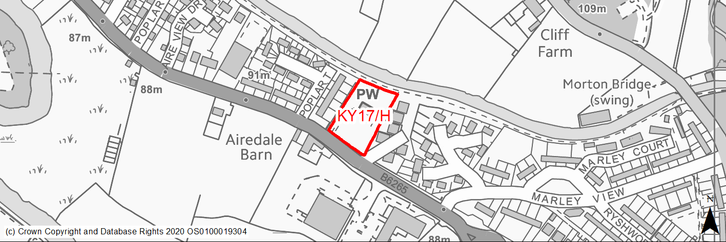
Site location
Principal Town - Keighley
Ward
Keighley East
Site description
The site consists of the former Church of Christ the King and its grounds. The site is currently for sale.
Proposed Allocation
Housing
SHLAA referencce
KY/049
Indicative no. dwellings
14
Site area (Gross) (ha)
0.41
Ownership
Private
Delivery timescales
Deliverable (1-5 years)
Type (PDL/Greenfield)
PDL
Green Belt
No
Flood Zone
Flood Zone 1
Potential site access
Site access is from B6265 Bradford Road.
Public Transport Accessibility
Bus: The nearest bus stops area located on Bradford Road (eastbound and westbound). The eastbound stop is located at the current site entrance, whilst westbound stop is located on southside of Bradford Road circa 100m to the west. These provide 5/6 services per hour towards Bingley and Bradford (eastbound) and Keighley (westbound). Service 662.
Rail: Crossflatts railway station is located 1.1km to the south east, whilst Keighley railway station is 3km to west.
Sustainability Appraisal
Bus: The nearest bus stops area located on Bradford Road (eastbound and westbound). The eastbound stop is located at the current site entrance, whilst westbound stop is located on southside of Bradford Road circa 100m to the west. These provide 5/6 services per hour towards Bingley and Bradford (eastbound) and Keighley (westbound). Service 662.
Rail: Crossflatts railway station is located 1.1km to the south east, whilst Keighley railway station is 3km to west.
Habitats Regulations Assessment
This site falls within 2.5km of the South Pennine Moors SPA/SAC a HRA must be undertaken to ensure there are no significant effects on these protected sites in terms of impact on supporting habitat which might be functionally linked to the SPA and recreational pressures. Developments within these zones must comply with Policy SP11; an SPD is being produced to provide further guidance.
Green Belt
N/A – Site not within the Green Belt.
Constraints and Opportunities
• This is a previously developed site within the built up area of Keighley (Riddlesden), consisting of a former church and its surroundings.
• It is immiediatelty adjacent to a Conservation Area (Leeds & Liverpool) and includes two areas of TPO woodland on the southern and northern boundaries.
• In addtional, the majority of the site is within the outer buffer for a major gas pipeline, with sections within the middle buffer.
• It is within the 2.5km buffer of the SPA/SAC.
Development considerations
• Design and layout should retain existing trees and be sensitive to the canal-side location.
• Identification and mitigation of impacts resulting from development on the adjacent Conservation Area (Leeds & Liverpool Canal).
• Design and layout should also take into account the buffer zones for a major gas pipeline.
• Appropriately designed access from Bradford Road should provided.
Conclusion/Summary
This is a sustainable site within the existing built up area of Keighley, with good access existing services and facilities in the surrounding area include schools and public houses. It is also well served by public transport provision, whilst employment opportunities are available nearby. It will deliver an estimated 14 dwellings.
(40) KY18/H - Moss Carr Road, Long Lee
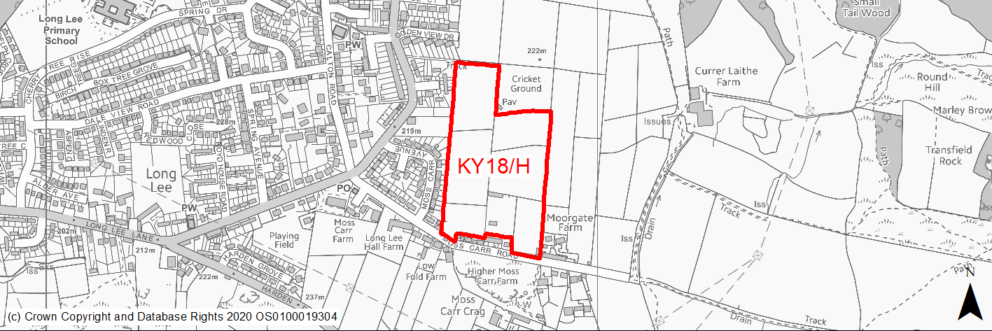
Site location
Principal Town - Keighley
Ward
Keighley East
Site description
The site is currently in agricultural use.
Proposed Allocation
Housing
SHLAA referencce
KY/054
Indicative no. dwellings
103
Site area (Gross) (ha)
4.94
Ownership
Private
Delivery timescales
Deliverable/Developable (1-10 years)
Type (PDL/Greenfield)
Greenfield
Green Belt
No
Flood Zone
Flood Zone 1
Potential site access
From Moss Carr Road.
Public Transport Accessibility
Bus: The nearest bus stops are located circa 210m to the west of the site on Long Lee Lane. This is served by 2 services per hour towards Thwaites Brow and Keighley town centre and bus station. Service K5.
Rail: Keighley railway station is located around 1.5km to the north west.
Sustainability Appraisal
Development at this site would be unlikely to result in a significant effect, either positive or negative, on any SA Objective.
Minor positive effects were predicted for most socio-economic themed SA Objectives due to the benefits of new residential development for the local economy as well as the location of the site in relation to transport links, health facilities and employment areas. However, access to both primary and secondary schools is somewhat limited due to the distances involved.
Minor adverse effects were also predicted for a range of natural environment themed SA Objectives, primarily as a result of the impacts of new development on a 100% greenfield site containing hedgerows with adjacent TPO woodland.
Habitats Regulations Assessment
This site falls within 7km of the South Pennine Moors SPA/SAC. A HRA must be undertaken to ensure there are no significant effects on these protected sites. Developments within these zones must comply with Policy SP11; a SPD is being produced to provide further guidance.
Green Belt
N/A – Site not within the Green Belt.
Constraints and Opportunities
• This is a large greenfield site within the settlement boundary for Keighley, on the eastern edge of the built up area. It is currently agricultural land bounded by dry stone walling.
• There is the potential for landscape and visual impacts.
• Access and the impacts on the wider network are potential issue.
• In addition, there is evidence of former coal mining activity within and adjacent to the site.
• It is within the 7km buffer of the SPA/SAC.
Development considerations
• Consideration should be given to addressing and mitigating any impacts on the wider highway network, in particular at Coney Lane Bridge.
• Ecological survey will be required to assess and mitigate potential impacts on habitats.
• Flood risk assessment is required (site over 1ha).
• An assessment of the former mineral workings is required.
• Appropriate Green Infrastructure/open space should be included within the design and layout of any development.
• Sensitive design and layout will be required to mitigate any potential landscape impacts and reflect the open nature of the area.
Conclusion/Summary
This is a sustainable site within the settlement boundary for Keighley with good access to local services and facilities including a community centre and GP surgery. It will deliver an estimated 103 dwellings, but will need a sensitive design to mitigate any andscape impacts, as well as addressing the impacts on the wider highway network with the eastern portion of the town. The site is currently the subject of an application for outline planning permisson.
(37) KY19/H - Long Lee Lane
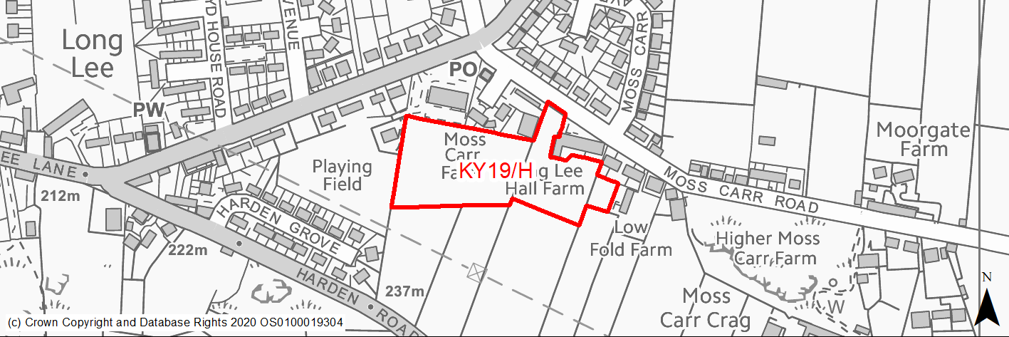
Site location
Principal Town - Keighley
Ward
Keighley East
Site description
The site consists of two agricultural fields that are currently used for animal grazing and area of garden land.
Proposed Allocation
Housing
SHLAA referencce
KY/056
Indicative no. dwellings
39
Site area (Gross) (ha)
1.25
Ownership
Private
Delivery timescales
Developable (6-10 years)
Type (PDL/Greenfield)
Greenfield
Green Belt
No
Flood Zone
Flood Zone 1
Potential site access
From Moss Carr Road.
Public Transport Accessibility
Bus: The nearest bus stops are located circa 70m to the north/north west of the site on Long Lee Lane. This is served by 2 services per hour towards Thwaites Brow and Keighley town centre and bus station. Service K5
Rail: Keighley railway station is located around 1.5km to the north west.
Sustainability Appraisal
No significant adverse effects have been predicted for the site. As a large greenfield site, minor adverse effects have been predicted for most natural environment themed SA Objectives. The site is well located to provide access to services and facilities, including bus links, shops, schools, and jobs, with particularly good access to health facilities.
Habitats Regulations Assessment
This site falls within 7km of the South Pennine Moors SPA/SAC. A HRA must be undertaken to ensure there are no significant effects on these protected sites. Developments within these zones must comply with Policy SP11; a SPD is being produced to provide further guidance.
Green Belt
N/A – Site not within the Green Belt.
Constraints and Opportunities
• This is a gently sloping, greenfield site within the settlement boundary for Keighley, in the Long Lee area of the town. It consists of agricultural fields and is adjacent to existing community facilties.
• Access and the impacts on the wider network are key issue whilst public transport access is limited to an hourly service.
• It is within the 7km buffer of the SPA/SAC.
Development considerations
• Consideration should be given to addressing and mitigating any impacts on the wider highway network, in particular at Coney Lane Bridge.
• Opportunities shjould be explored for improving access by public transport.
• Appropriate consideration should be given to the adjacent land uses. Flood risk assessment will be required (site is over 1ha).
Conclusion/Summary
This is a sustainabe site within the settlement boundary for Keighley with good access to local services and facilities including a community centre and GP surgery. It will deliver an estimated 39 dwellings, but will need to address the impacts on the wider highway network with the eastern portion of the town.
(10) KY20/HC - Redwood Close
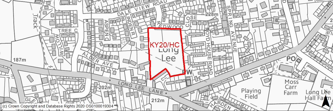
Site location
Principal Town - Keighley
Ward
Keighley East
Site description
This site consists of fields that gently slope from Redwood Close down towards Long Lee Lane.
Proposed Allocation
Housing
SHLAA referencce
KY/057
Indicative no. dwellings
45
Site area (Gross) (ha)
1.13
Ownership
Private
Delivery timescales
Developable (6-10 years)
Type (PDL/Greenfield)
Greenfield
Green Belt
No
Flood Zone
Flood Zone 1
Potential site access
The site would be accessed off Redwood Close.
Public Transport Accessibility
Public transport accessibility has been taken into account as part of the planning application process.
Sustainability Appraisal
The site could deliver a major positive effect for residents on the health SA Objective as a result of being within the target distances for all necessary health facilities.
Minor positive effects were predicted for most socio-economic themed SA Objectives due to the benefits of new residential development for the local economy as well as the location of the site in relation to transport links, education facilities and employment areas.
No major adverse effects have been predicted for the site, but minor adverse effects were predicted for a range of natural environment themed SA Objectives, primarily as a result of the impacts of new development on a 100% greenfield site. Any negative impact this may have on the local landscape and townscape is somewhat limited due to the site being surrounded by existing residential built form.
Habitats Regulations Assessment
This site falls within 7km of the South Pennine Moors SPA/SAC a HRA must be undertaken to ensure there are no significant effects on these protected sites in terms of recreational pressures. Developments within these zones must comply with Policy SP11; an SPD is being produced to provide further guidance.
Green Belt
N/A – Site not within the Green Belt.
Constraints and Opportunities
• Relevant constraints and opportunities have been considered as part of the planning application process.
Development considerations
• Relevant development considerations have been taken into account as part of the planning application process.
Conclusion/Summary
This site has outline planning permission for 45 dwellings (17/02809/MAO approved 05.07.18).
(2) KY21/HC - Parkwood Rise
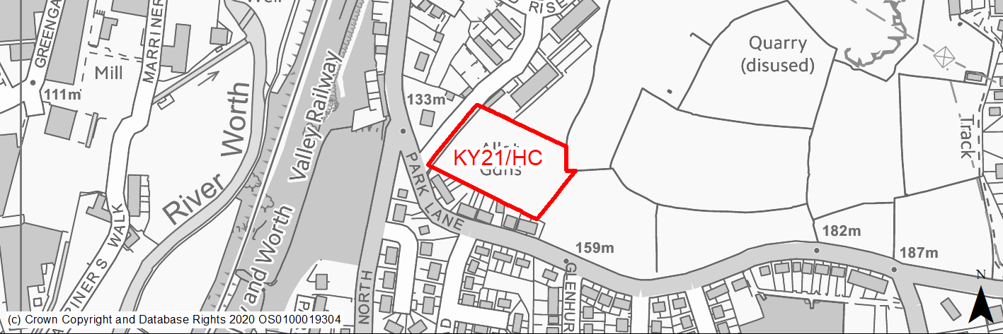
Site location
Principal Town - Keighley
Ward
Keighley East
Site description
This site consists of former allotments now overgrown and uneven.
Proposed Allocation
Housing
SHLAA referencce
KY/059
Indicative no. dwellings
28
Site area (Gross) (ha)
0.74
Ownership
Private
Delivery timescales
Developable (6-10 years)
Type (PDL/Greenfield)
Greenfield
Green Belt
No
Flood Zone
Flood Zone 1
Potential site access
The site would be accessed off Parkwood Rise.
Public Transport Accessibility
Public transport accessibility has been taken into account as part of the planning application process.
Sustainability Appraisal
Development at this site would be unlikely to result in a major effect, either positive or negative, on any SA Objective.
Minor positive effects were predicted for most socio-economic themed SA Objectives due to the benefits of new residential development for the local economy as well as the location of the site in relation to transport links, local amenities, education facilities and employment areas.
Minor adverse effects were predicted for a range of natural environment themed SA Objectives, primarily as a result of the impacts of new development on a 100% greenfield site with nearby TPO woodland.
Habitats Regulations Assessment
This site falls within 7km of the South Pennine Moors SPA/SAC a HRA must be undertaken to ensure there are no significant effects on these protected sites in terms of recreational pressures. Developments within these zones must comply with Policy SP11; an SPD is being produced to provide further guidance.
Green Belt
N/A – Site not within the Green Belt.
Constraints and Opportunities
• Relevant constraints and opportunities have been considered as part of the planning application process.
Development considerations
• Relevant development considerations have been taken into account as part of the planning application process.
Conclusion/Summary
This site has outline planning permission for 28 dwellings (14/05292/MAO approved 01.04.15).
(4) KY22/H - Parkwood Rise
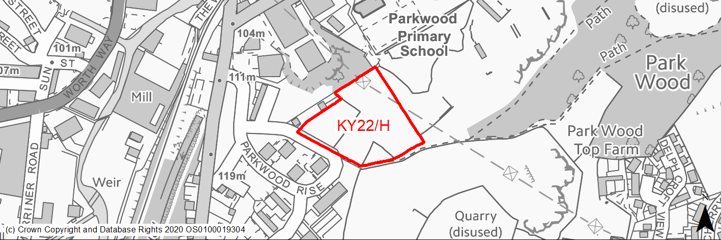
Site location
Principal Town - Keighley
Ward
Keighley East
Site description
The site consists of a former football pitch and an area of vacant scrubland.
Proposed Allocation
Housing
SHLAA referencce
KY/060
Indicative no. dwellings
33
Site area (Gross) (ha)
1.04
Ownership
Mixed
Delivery timescales
Developable (6-10 years)
Type (PDL/Greenfield)
Greenfield
Green Belt
No
Flood Zone
Flood Zone 1
Potential site access
From Parkwood Rise.
Public Transport Accessibility
Bus: There are bus stops located close to the site on Parkwood Rise, however these do not have a service. The nearest stops with a regular service are located circa 150m to the north west of the site on Park Lane. These offer 3 services per hour towards Keighley Bus Station (inbound) and Oxenhope/Oakworth (1 per hour) and Thwaites Brow (2 per hour). Services K5 & K10.
Rail: Keighley railway station is located around 650m (in a straight line)/900m (via quickest walking route) (12 mins) to the north. This offers 4 services per hour towards Bradford & Leeds (2 services per hour to each) and Skipton. Also has other limited services to Carlisle and Lancaster/Morecambe.
Sustainability Appraisal
No significant adverse effects have been predicted for the site. As a large greenfield site, minor adverse effects have been predicted for most natural environment themed SA Objectives. The site is well located to provide access to services and facilities, including shops, health facilities, and jobs, with particularly good access to schools and sustainable transport modes.
Habitats Regulations Assessment
This site falls within 7km of the South Pennine Moors SPA/SAC. A HRA must be undertaken to ensure there are no significant effects on these protected sites. Developments within these zones must comply with Policy SP11; a SPD is being produced to provide further guidance.
Green Belt
N/A – Site not within the Green Belt.
Constraints and Opportunities
• This is a moderate to steeply sloping greenfield site within the settlement boundary for Keighley. It is a mixture of woodland, a former football pitch and grazing area, that adjoins established areas of residential development, employment, woodland/open space and a former quarry.
• A number of trees and hedgerows present within the site, whilst a public right of way runs along the southern boundary.
• A high voltage electricity transmission line cross the northern section.
• Within a Green Infrastructure as well as the 7km buffer of the SPA/SAC.
Development considerations
• Design and layout should take account of the high voltage electricity transmission line, in line with National Grid guidance.
• Opportunities should be investigated to improve the adjacent Public Right of Way.
• Access is available from Parkwood, however consideration should be given to addressing and mitigating any impacts on the wider highway network, in particular at Coney Lane Bridge.
Conclusion/Summary
This is a sustainable site within the settlement boundary for Keighley with good access to local services and facilities including a primary school and public house. It is also within walking dstance of Keighley town centre. It will deliver an estimated 33 dwellings, but will need to address the impacts on the wider highway network with the eastern portion of the town.
(3) KY23/H - Walk Mills, The Walk
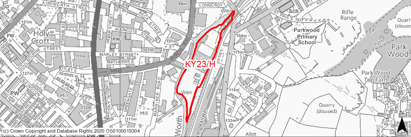
Site location
Principal Town - Keighley
Ward
Keighley Central
Site description
The site consists of a number of under used former mill buildings and an area of vacant land. It mainly for employment purposes including haulage and storage.
Proposed Allocation
Housing
SHLAA referencce
KY/064
Indicative no. dwellings
55
Site area (Gross) (ha)
1.69
Ownership
Private
Delivery timescales
Developable (6-10 years)
Type (PDL/Greenfield)
PDL
Green Belt
No
Flood Zone
Flood Zone 1 (9%), Flood Zone 2 (62%), Flood Zone 3 (23%), Flood Zone 3b (7%)
Potential site access
Site access is from The Walk via Park Lane. Appropriate visibility splays and junction radii improvements may be required.
Public Transport Accessibility
Bus: The nearest bus stops are located around 40m to the east of the site on Park Lane. These provide 2 services per hour to Keighley bus station (inbound) and 2 (occasionally 3) services per hour (outbound) to Thwaites Brow & Oakworth. The bus station is located in the town centre (around 650m/9 minutes via the quickest walking route).
Rail: Keighley railway station is located around 500m (in a straight line)/650m (via quickest walking route) (circa 8 minutes) to the north of the site. This provides 9 (occasionally 10) services per hour towards Skipton (4 per hour), Leeds (3 per hour) and Bradford Forster Square (2 per hour), and Carlisle/Morecambe (roughly every 2 hours).
Sustainability Appraisal
The site could deliver major positive effects for residents on both the health and transport SA Objectives, as a result of being within the target distances for all necessary health facilities, as well as bus stops and a railway station.
A major adverse effect arises for the climate change resilience SA objective due to the site falling within the active zone flood zones FZ2, FZ3a and FZ3b. More detailed flood risk assessments would likely be required for the site.
As a PDL site, there are opportunities here for achieving biodiversity net gains and improvements to the local character, depending on the implementation of the development. The site falls within the South Pennine Moors SSSI/SPA/SAC Impact Risk Zones; thus, Natural England would need to be consulted to ensure no adverse effects on designated sites. Minor positive effects were also predicted for most socio-economic themed SA Objectives due to the benefits of new residential development for the local economy as well as the location of the site in relation to local amenities and education facilities.
Habitats Regulations Assessment
This site falls within 7km of the South Pennine Moors SPA/SAC. A HRA must be undertaken to ensure there are no significant effects on these protected sites. Developments within these zones must comply with Policy SP11; a SPD is being produced to provide further guidance.
Green Belt
N/A – Site not within the Green Belt.
Constraints and Opportunities
• This is a previously development site within the Keighley built up area, and is currently occupied by a number of businesses.
• The site is a Green Infrastructure corridor along the River Worth and is overlooked by a heritage railway line.
• It is mostly within Flood Zone 2 with elements of Flood Zone 3.
• A public right of way runs through the site.
• A Grade II listed building is located to the north of the site.
• It also within the 7km buffer of the SPA/SAC.
Development considerations
• A Flood Risk Assessment is required.
• Sensitive design and layout will be required to ensure that development is directed to those areas at lowest risk of flooding and that impact on views adjacent heritage railway line are mitigate.
• Ecology/Habitat assessment is required as is a heritage assessment.
• Access is available from Park Lane/Coney Lane, however a solution is required to ensure the most appropriate layout and visibility is improved.
Conclusion/Summary
This is a previously developed site, sustainably located within the Keighley built up area, It is close proximity to local services and facilities including schools, shops and facilities within Keighley town centre. It is also in close proximity to frequent public transport services available in the town centre. It will deliver an estimated 55 dwellings, however it will need ensure that design mitigates potential flood risk. This site is currently the subject of an application for outline planning permission for residential development in conjunction with site KY24/H (KY/065A): Marriner Road.
(2) KY24/H - Marriner Road
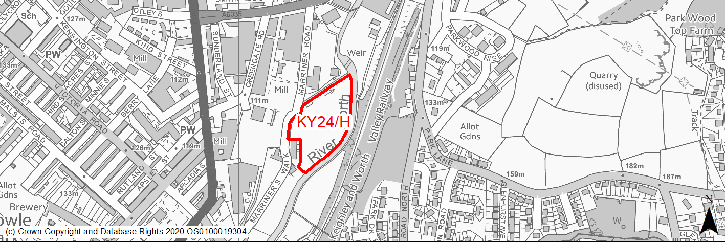
Site location
Principal Town - Keighley
Ward
Keighley Central
Site description
The site consists of a former cricket pitch that is used as an area for informal recreation.
Proposed Allocation
Housing
SHLAA referencce
KY/065A
Indicative no. dwellings
30
Site area (Gross) (ha)
1.21
Ownership
Private
Delivery timescales
Developable (6-10 years)
Type (PDL/Greenfield)
Greenfield
Green Belt
No
Flood Zone
Flood Zone 1 (1%), Flood Zone 2 (11%), Flood Zone 3 (88%)
Potential site access
Access could be taken from Marriner Road (with new junction being created).
Public Transport Accessibility
Bus: The nearest bus stop is located around 200m to the north west on Worth Way. This provides 3 services per hour to Keighley Bus Station (Service K9). Other bus stops with more frequent services are located around 190m and 200m to the west on South Street. The former provides 7 services to Keighley Bus Station (northbound) and 7 services per hour to Hebden Bridge (1 per hour), Bracken Bank (3 per hour), Stanbury (1 per hour), Bradford City Centre (1 per hour) & Oakworth (1 per hour) (southbound). (Services 67, B1, B2, B3 & K9). Rail: Keighley railway station is located around 840m (in a straight line)/1km (via quickest walking route) (circa 13 mins) to the north east.
Sustainability Appraisal
The site could deliver a major positive effect for residents on the health SA Objective as a result of being within the target distances for all necessary health facilities.
A major adverse effect arises for the climate change resilience SA objective due to the site falling entirely within the active zone flood zones FZ2 and FZ3. More detailed flood risk assessments would likely be required for the site, and careful consideration given to the layout of the development.
Minor positive effects were predicted for most socio-economic themed SA Objectives due to the benefits of new residential development for the local economy as well as the location of the site in relation to transport links, local amenities, education facilities and employment areas.
Minor adverse effects were predicted for a range of natural environment themed SA Objectives, primarily as a result of the impacts of new development on a 100% greenfield site.
Habitats Regulations Assessment
This site falls within 7km of the South Pennine Moors SPA/SAC. A HRA must be undertaken to ensure there are no significant effects on these protected sites. Developments within these zones must comply with Policy SP11; a SPD is being produced to provide further guidance.
Green Belt
N/A – Site not within the Green Belt.
Constraints and Opportunities
• This is a greenfield site within the Keighley built up area, it is currently an area of open space. Historically it was cricket pitch.
• Much of the site is within Flood Zone 3 and forms part of the grassland habitat network, whilst TPO trees and woodland are present.
• It also within the 7km buffer of the SPA/SAC.
Development considerations
• A Flood Risk Assessment is required.
• Sensitive design and layout will be required to ensure that development is directed to those areas at lowest risk of flooding and that appropriate mitigation is provided.
• Ecology/Habitat assessment is required.
• Access is available via Marriner Road, although a new entrance will be required.
Conclusion/Summary
This is a greenfield site, sustainably located within the Keighley built up area, It is close proximity to local services and facilities including schools, shops and facilities within Keighley town centre. It is also in close proximity to frequent public transport services available in the town centre. It will deliver an estimated 30 dwellings, however it will need ensure that design mitigates potential flood risks. This site is currently the subject of an application for outline planning permission for residential development in conjunction with site KY23/H (KY/064): Walk Mills.
(2) KY25/H - Hainworth Road
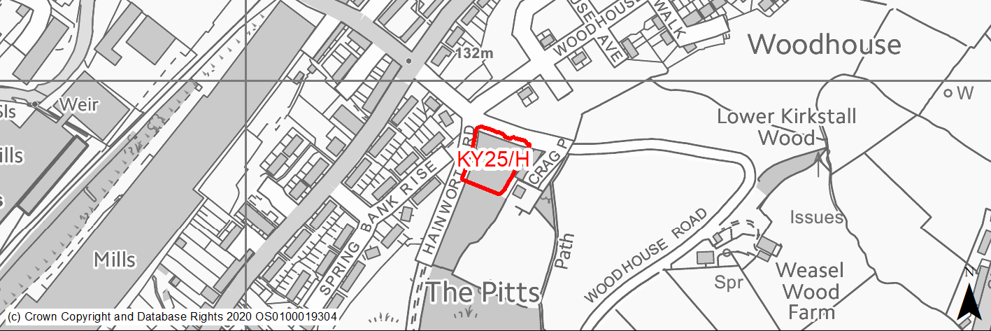
Site location
Principal Town - Keighley
Ward
Keighley East
Site description
The site consists of an area of open land with a large number of trees, particularly towards the southern end.
Proposed Allocation
Housing
SHLAA referencce
KY/069A
Indicative no. dwellings
6
Site area (Gross) (ha)
0.23
Ownership
Council
Delivery timescales
Developable (6-10 Years)
Type (PDL/Greenfield)
Greenfield
Green Belt
No
Flood Zone
Flood Zone 1
Potential site access
From Woodhouse Road or Hainworth Road. Site is close to a crossroads (junction Hainworth Road/Woodhouse Road).
Public Transport Accessibility
Bus: The nearest bus stops are located circa 70 & 90m to the north west of the site on Hainworth Wood Road. These stops provide 1 service per hour towards Keighley (inbound) and Oakworth (outbound). Service K10.
Rail: Keighley railway station is located around 1.4km to the north.
Sustainability Appraisal
Development at this site would be unlikely to result in a significant effect, either positive or negative, on any SA Objective.
Minor positive effects were predicted for most socio-economic themed SA Objectives due to the benefits of new residential development for the local economy as well as the location of the site in relation to transport links, local amenities, education facilities and employment areas.
Minor adverse effects were predicted for a range of natural environment themed SA Objectives, primarily as a result of the impacts of new development on a 100% greenfield site.
Habitats Regulations Assessment
This site falls within 7km of the South Pennine Moors SPA/SAC. A HRA must be undertaken to ensure there are no significant effects on these protected sites. Developments within these zones must comply with Policy SP11; a SPD is being produced to provide further guidance.
Green Belt
N/A – Site not within the Green Belt.
Constraints and Opportunities
• This is a small greenfield site within the Keighley built up area, on the edge of an established residential area. It is in a prominent location at the junction of several roads.
• There is an area of woodland to the south include TPO woodland. It is also within a Green Infrastructure corridor.
• A public right of way runs along the western boundary.
• Public transport provision is limited.
• It is within the 7km buffer of the SPA/SAC.
Development considerations
• Consideration should be given to addressing and mitigating any impacts on the wider highway network, in particular at Coney Lane Bridge.
• Opportunities should be explored for improving access by public transport.
• Design should take into the prominent position of the site and include appropriate mitigation measures to reduce impacts on the surrounding area including neighbouring residential areas.
• Existing mature trees should be retained, where possible.
• Access is available from the adjacent highway network.
Conclusion/Summary
This is a sustainable site within the settlement boundary for Keighley with access to local services and facilities. It will deliver an estimated 6 dwellings, but will need to address the impacts on the wider highway network with the eastern portion of the town.
(2) KY26/H - Hainworth Road
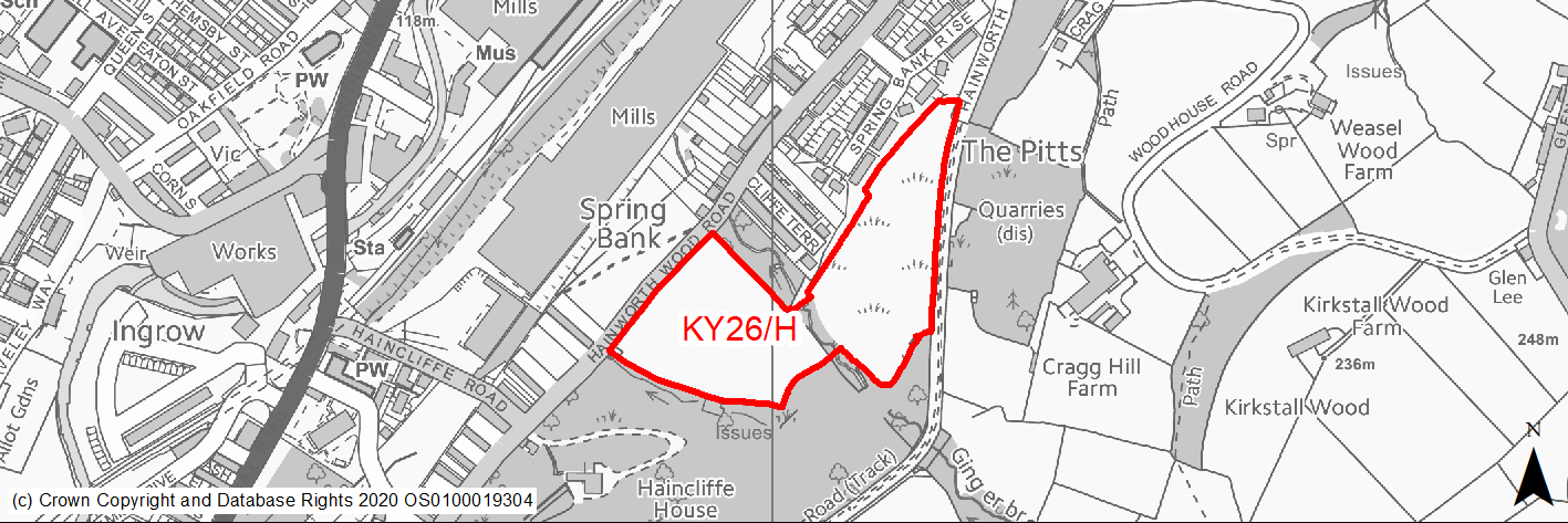
Site location
Principal Town - Keighley
Ward
Keighley East
Site description
The site consists of two areas of open area of land that are used for animal grazing on the eastern edge of Keighley. Each area is bounded by mature trees and woodland, and are separated by a watercourse. Both areas of land were identified in the SHLAA as two separate sites.
Proposed Allocation
Housing
SHLAA referencce
KY/070 & KY/071
Indicative no. dwellings
75
Site area (Gross) (ha)
3.23
Ownership
Council
Delivery timescales
Developable (6-10 years)
Type (PDL/Greenfield)
Greenfield
Green Belt
No
Flood Zone
Flood Zone 1
Potential site access
Potential access is from Hainworth Wood Road.
Public Transport Accessibility
Bus: The nearest bus stops are located circa 95m to the west of the site on Hainworth Wood Road. These stops provide 1 service per hour towards Keighley (inbound) and Oakworth (outbound). Service K10.
Rail: Keighley railway station is located around 1.5km to the north.
Sustainability Appraisal
See individual Sustainability Appraisal site comment in the accompanying report.
Habitats Regulations Assessment
This site falls within 7km of the South Pennine Moors SPA/SAC. A HRA must be undertaken to ensure there are no significant effects on these protected sites. Developments within these zones must comply with Policy SP11; a SPD is being produced to provide further guidance.
Green Belt
N/A – Site not within the Green Belt.
Constraints and Opportunities
• This is a sloping, greenfield site within the settlement boundary for Keighley on the eastern edge of the built up area, adjoining an existing residential area.
• It represents an opportunity to create high quality development in a parkland setting.
• It is adjacent to Local Wildlife Site and in close proximity to an area of Ancient Woodland.
• TPO trees and woodland are adjacent to the southern and eastern boundaries. Other sections run through the site.
• Watercourses run through the site as well as adjacent to the southern boundary.
• It is within the 7km buffer of the SPA/SAC
Development considerations
• Ecology survey will be required to identify potential impacts on adjoining habitats.
• Design and layout should sensitive to adjoining habitats and presence of the water course as well as to address issues with gradients.
• Arboricultural assessment will be required and where possible important trees should be retained within any layout.
• Green infrastructure/open space should be be provided/enhanced.
• A Flood Risk Assessment will be required, whilst surface water flooding and drainage issues should be mitigated.
• Access is available from Hainworth Wood Road, although most appropriate should be investigated and any road layout should provide access to the north section of the site.
Conclusion/Summary
This is a sustainable site within the settlement boundary for Keighley with access to local services and facilities as employment opportunities. Any design and layout should be sensitive to the presence of the various habitat and biodiversity designations, and reduce potential access issues. It should contain significant opportunities for Green Infrastructure and open space provision. The site will deliver an estimated 75 dwellings.
(2) KY27/H - Hainworth Lane/ Halifax Road
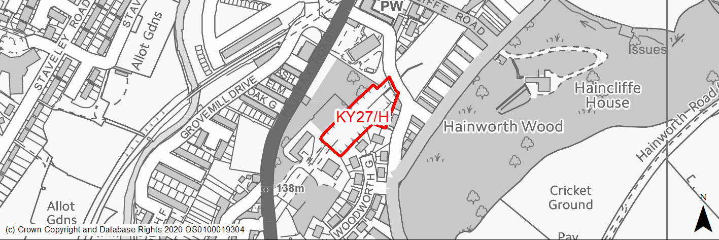
Site location
Principal Town - Keighley
Ward
Keighley East
Site description
The site consists of a cutting containing the trackbed of a former railway line, which has been partially backfilled with waste material. It also includes an area of woodland located between the former railway line and Halifax Road. A section of the site on Halifax Road is used for car sales. At the northern end of the site a former overbridge and retaining walls are present.
Proposed Allocation
Housing
SHLAA referencce
KY/073
Indicative no. dwellings
11
Site area (Gross) (ha)
0.4
Ownership
Private
Delivery timescales
Deliverable/Developable (1-10 years)
Type (PDL/Greenfield)
Greenfield
Green Belt
No
Flood Zone
Flood Zone 1
Potential site access
From Hainworth Lane via Haincliffe Place (Potential).
Public Transport Accessibility
Bus: The nearest bus stops are located to the west of the site on Halifax Road. One is immediately adjacent to the western boundary, whilst another is on the opposite side of the road. Another stops is adjacent to the south west corner of the site. These stops offer 4 services per hour towards Keighley Bus Station (inbound) and Hebden Bridge (1 per hour), Stanbury (1 per hour), Bradford (1 per hour) and Oakworth (1 per hour) (outbound). Services 67, B1, B2, B3 & K15.
Rail: Keighley railway station is located around 2km to the north east.
Sustainability Appraisal
The site could deliver major positive effects for residents on both the health and education SA Objectives, as a result of being within the target distances for all necessary health facilities and centres for primary and secondary education.
Minor positive effects were predicted for nearly all other socio-economic themed SA Objectives due to the benefits of new residential development for the local economy as well as the location of the site in relation to transport links, local amenities and employment areas.
No major adverse effects have been predicted for the site, but minor adverse effects were predicted for a range of natural environment themed SA Objectives, primarily as a result of the impacts of new development on a 100% greenfield site which overlaps deciduous woodland priority habitat and adjoins TPO woodland.
Habitats Regulations Assessment
This site falls within 7km of the South Pennine Moors SPA/SAC. A HRA must be undertaken to ensure there are no significant effects on these protected sites. Developments within these zones must comply with Policy SP11; a SPD is being produced to provide further guidance.
Green Belt
N/A – Site not within the Green Belt.
Constraints and Opportunities
• This is a greenfield site within the Keighley built up area that was previously a railway cutting which was infilled with inert waste.
• There are a number of TPO trees within the site and areas of TPO woodland adjacent to it.
• Part of the site includes an area of priority habitat (woodland).
• It is within the 7km buffer of the SPA/SAC.
Development considerations
• TPO trees and woodland should be retained in order to maintain the green "feel" of the surrounding area.
• Further investigations are required to identify an apppropriate access from the adjacent highway network.
• Ecological survey required to assess and mitigate impacts on priority habitats and species.
• Contaminated land survey required to assess and mitigate impacts of previous use.
Conclusion/Summary
This is a sustainable site within the existing built up area of Keighley, with good access existing services and facilities in the surrounding area including. It is also well served by public transport provision, whilst employment opportunities are available nearby. It will deliver an estimated 11 dwellings.
(2) KY28/H - Staveley Way
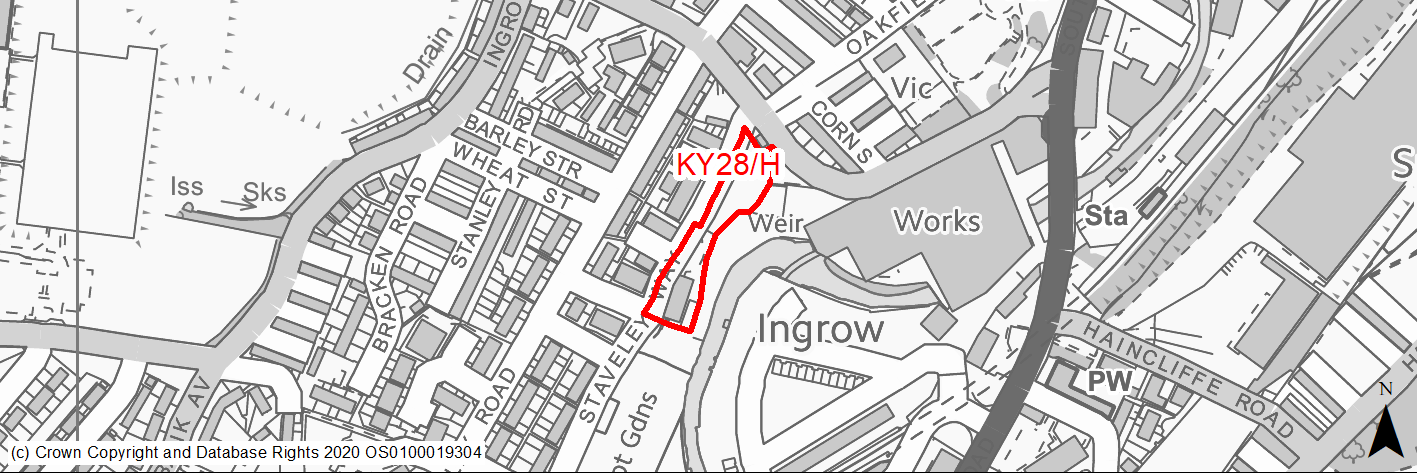
Site location
Principal Town - Keighley
Ward
Keighley West
Site description
The site consists of an area of underused land and former allotments which slopes quite steeply towards the River Worth. Former engineering works now disused sits within site. Rest is mainly used for animal pens and allotments. Although there have been residential permissions on the site, all have now lapsed or have been refused.
Proposed Allocation
Housing
SHLAA referencce
KY/075
Indicative no. dwellings
10
Site area (Gross) (ha)
0.3
Ownership
Private
Delivery timescales
Developable (6-10 years)
Type (PDL/Greenfield)
Greenfield
Green Belt
No
Flood Zone
The majority of the site is located in Flood Zone 1. However, there are sections that are within FZ2 (0.02ha) and FZ3 (0.02ha) within the eastern boundary, adjacent to the River Worth.
Potential site access
From Ingrow Lane. Other potential access points are from Staveley Road via Ebony View or Staveley Way. These are narrow and in poor condition.
Public Transport Accessibility
Bus: The nearest bus stops are located on Staveley Road (60m to the west) and Ingrow Lane (25m to the north west). The former offers 4 services per hour towards Keighley Bus Station, whilst the latter offers an hourly service towards Oakworth (outbound) and Keighley Bus Station (inbound). Services K9 & K10.
Rail: Keighley railway station is located 1.9km to the north east.
Sustainability Appraisal
The site could deliver major positive effects for residents on both the health and education SA Objectives, as a result of being within the target distances for all necessary health facilities and centres for primary and secondary education. Minor positive effects were predicted for nearly all other socio-economic themed SA Objectives due to the benefits of new residential development for the local economy as well as the location of the site in relation to transport links, local amenities and employment areas.
As a PDL site, there are opportunities here for achieving biodiversity net gains and improvements to the local character, depending on the implementation of the development.
No major adverse effects have been predicted for the site, but the River Worth is within 10m of the site and as such careful consideration around protecting water quality would be required.
Habitats Regulations Assessment
This site falls within 7km of the South Pennine Moors SPA/SAC. A HRA must be undertaken to ensure there are no significant effects on these protected sites. Developments within these zones must comply with Policy SP11; a SPD is being produced to provide further guidance.
Green Belt
N/A – Site not within the Green Belt.
Constraints and Opportunities
• This is a partially previously developed and greenfield site within the settlement boundary for Keighley that is currently occupied by areas of hard standing and a derelict industrial building.
• It is within a Green Infastructure corridor and adjacent to a steep towards the River Worth.
• A public right of way runs through the western boundary of the site.
• Within 7km buffer of the SPA/SAC.
Development considerations
• Sensitive design and layout is required to reflect is location within a key GI corridor and adjacent to the River Worth as well as to facilitate public access along the river corridor.
• Contamination land survey will be required to assess and mitigate potential issues resulting from previous uses.
• Ecology survey required.
• Access available from Ingrow Lane, however further investigation required to establish the most appropriate design.
Conclusion/Summary
This is a sustainable site within the existing built up area of Keighley with good access to services and facilities including primary and secondary schools and shops as well as public transport services. Employment opportunities are also nearby. It will deliver an estimated 10 dwellings, however it will required sensitive layout and design to ensure that the green corridor along the River Worth is maintained and enhanced.
(2) KY29/H - Woodhouse Road
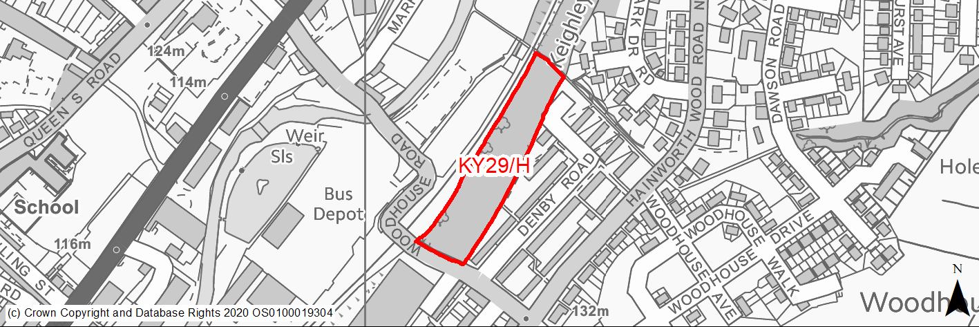
Site location
Principal Town - Keighley
Ward
Keighley East
Site description
The site forms part of the trackbed of former railway line. It currently consists of woodland with a footpath running through it. Used for informal recreation.
Proposed Allocation
Housing
SHLAA referencce
KY/081
Indicative no. dwellings
24
Site area (Gross) (ha)
1.06
Ownership
Private
Delivery timescales
Deliverable/Developable (1-10 years)
Type (PDL/Greenfield)
Greenfield
Green Belt
No
Flood Zone
Flood Zone 1
Potential site access
From Woodhouse Road.
Public Transport Accessibility
Bus: The nearest bus stops are located around 80m to the south east of the site Hainworth Wood Road. These provide 1 service per hour towards Keighley (inbound) and Oakworth (outbound). Service K10.
Rail: Keighley railway station is located around 1km to the north west.
Sustainability Appraisal
The site could deliver a major positive effect for residents on the health SA Objective as a result of being within the target distances for all necessary health facilities.
Minor positive effects were predicted for most other socio-economic themed SA Objectives due to the benefits of new residential development for the local economy as well as the location of the site in relation to transport links, local amenities, education facilities and employment areas.
No major adverse effects have been predicted for the site, but minor adverse effects were predicted for a range of natural environment themed SA Objectives, primarily as a result of the impacts of new development on a 100% greenfield site which is almost entirely deciduous woodland priority habitat.
Habitats Regulations Assessment
This site falls within 7km of the South Pennine Moors SPA/SAC. A HRA must be undertaken to ensure there are no significant effects on these protected sites. Developments within these zones must comply with Policy SP11; a SPD is being produced to provide further guidance.
Green Belt
N/A – Site not within the Green Belt.
Constraints and Opportunities
• This is a greenfield site within the Keighley built up area, that is currently an open area of land, adjoining an existing residential area. It previously formed the trackbed of a former railway line.
• The site is identified as part of a woodland habitat network and contains a number of trees that run alongside the adjacent heritage railway line.
• A public right of way and watercourse runs along the northern boundary.
• Within the 7km buffer of the SPA/SAC.
Development considerations
• Design and layout should respect the location adjacent to the Green Infrastructure corridor along the River Worth.
• Ecology survey required.
• Impact on the Keighley & Worth Valley Railway should be considered.
• Surface water flooding and drainage issues should be mitigated.
• A new access point will need to be provided, with the most appropriate location requiring further location.
Conclusion/Summary
This is a sustainable site within the Keighley built up area. It will deliver an estimated 24 dwellings.
(3) KY30/H - Beck Street/Bridge Street
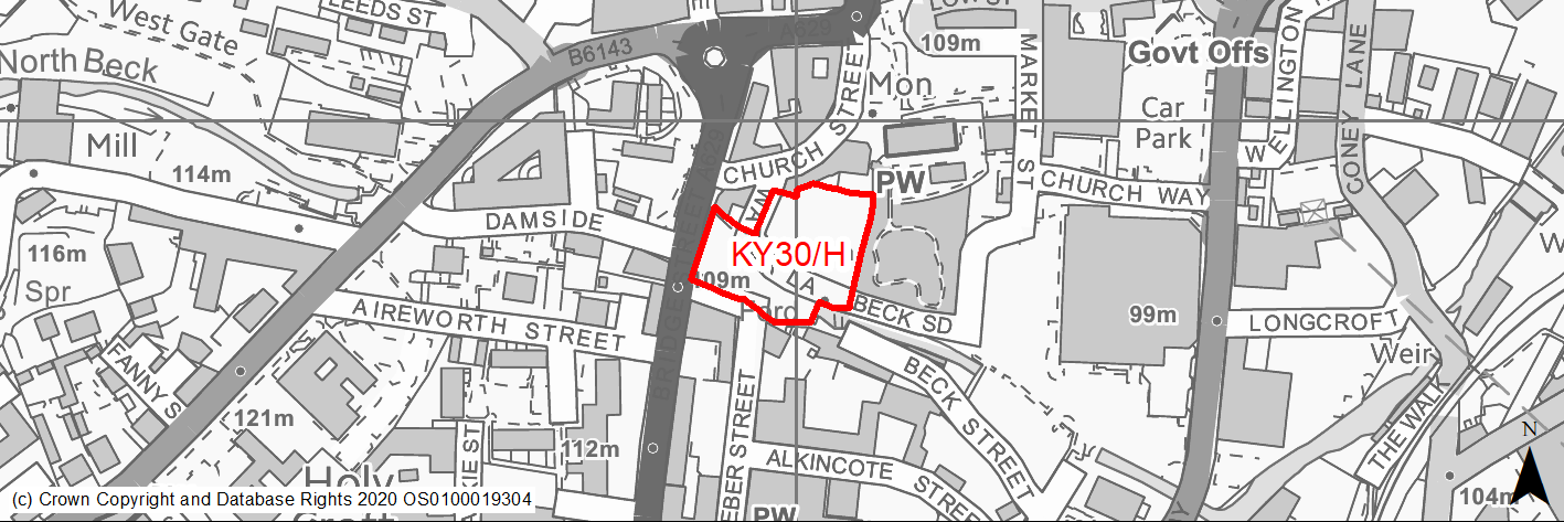
Site location
Principal Town - Keighley
Ward
Keighley Central
Site description
The site consists of vacant land that was formerly occupied by a mill, which has been demolished. It has been cleared and prepared for development. Site has a legacy of unimplemented planning permissions for retail and/or residential development. A small element of the site is used for car parking for adjacent businesses.
Proposed Allocation
Housing
SHLAA referencce
KY/083
Indicative no. dwellings
39
Site area (Gross) (ha)
0.57
Ownership
Private
Delivery timescales
Developable (6-10 years)
Type (PDL/Greenfield)
PDL
Green Belt
No
Flood Zone
Flood Zone 1 (98.2%), Flood Zone 2 (0.5%), Flood Zone 3 (0.4%) & Flood Zone 3b (0.9%). Affects the south east corner adjacent to North Beck.
Potential site access
Access point is via Water Lane from Church Street. Possible alternative access is available from the south via Beck Lane.
Public Transport Accessibility
Bus: Bus stops are located on Bridge Street circa 50m to the north west of the site and South Street circa 95m to the south west of the site. The former offers 4 services per hour towards Bracken Bank (3 per hour) & Bradford (1 per hour), whilst the latter offers 4 services per hour towards Keighley Town Centre. Services 67, B1, B2, B3 & K9.
Rail: Keighley Railway Station is located around 630m to north east of site (in a straight line)/around 800m (via shortest walking route). This offers 4 services per hour towards Bradford & Leeds (2 services per hour to each) and Skipton. Also has other limited services to Carlisle and Lancaster/Morecambe.
Sustainability Appraisal
As a PDL site in the centre of Keighley, KY/083 would be an efficient use of the land resource and would provide residents with excellent access to key services and amenities, including shops, cultural spaces, and recreational areas, with particularly good access to schools and sustainable transport options. The site is a good opportunity to deliver biodiversity net gains and improvements to the local townscape character, as well as the vitality of Keighley’s centre. A large portion of the site is at a risk of surface water flooding, which may require careful consideration through any planning application for development here.
Habitats Regulations Assessment
This site falls within 7km of the South Pennine Moors SPA/SAC. A HRA must be undertaken to ensure there are no significant effects on these protected sites. Developments within these zones must comply with Policy SP11; a SPD is being produced to provide further guidance.
Green Belt
N/A – Site not within the Green Belt.
Constraints and Opportunities
• This is a level, vacant, previously developed site within the built up area of Keighley, on the edge of the town centre. It represents an opportunity to regenerate a derelict site in prominent edge of centre location and improve the townscape. It was previously occupied by a mill building.
• It is within the Keighley Conservation and directly adjacent to several Grade II Listed Buildings.
• Parts of of the site are within flood zones 2 & 3, whilst there is potential for Surface Water Flooding.
• It is within the 7km buffer of the SPA/SAC.
Development considerations
• Contaminated land survey required to assess and mitigate impacts of previous use.
• Heritage assessment will be required to identifying and mitigate impacts on the Conservation Area and adjacent Listed Building.
• Archaeology assessment may be required.
• Flood risk and drainage assessment will be required to identify and mitigate impacts of any flooding and drainage issues.
• Noise assessment may be required.
• Design should incorporate Green Infrastructure to aid the connectivity of existing assets (North Beck & River Worth).
• Potential to enhance public accees to North Beck should be investigated.
• Access available from surrounding highway network.
Conclusion/Summary
This is a sustainable site on the edge of Keighley town centre with good access to local services including shops, medical centres and cultural facilities. In addition, employment opportunities are accessible in the town centre. It is also well served by frequent public transport services. It will regenerate a derelict, previously developed site. There also opportunities to improve Green Infrastructure and support biodiversity net gain. It will deliver an estimated 39 dwellings.
(1) KY31/H - Cark Road
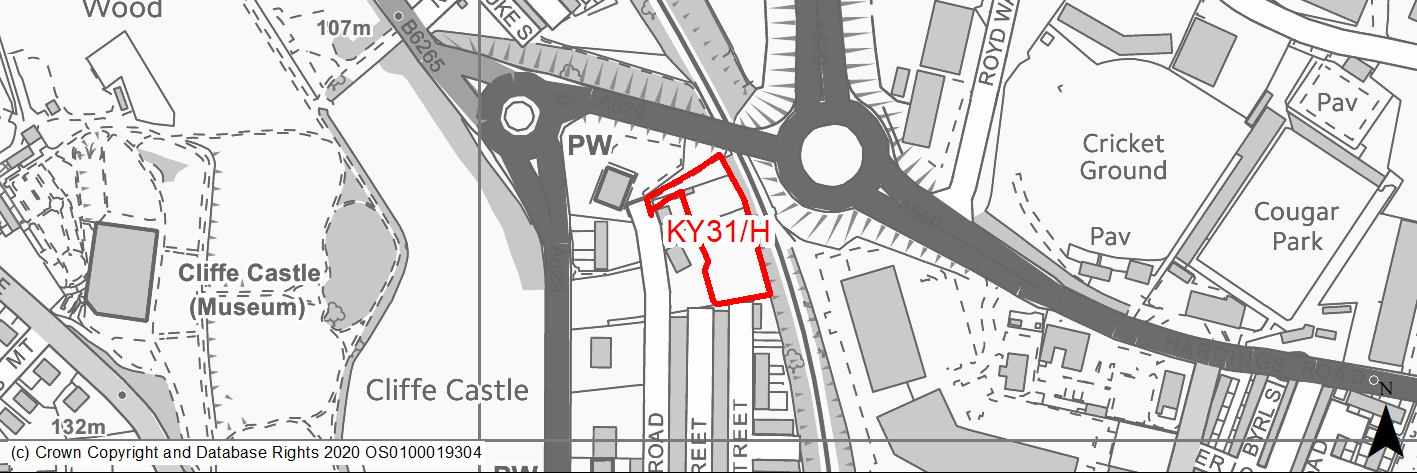
Site location
Principal Town - Keighley
Ward
Keighley Central
Site description
The site consists of garden land an existing two existing dwellings (Ryelands & Oatlands), which is currently overgrown.
Proposed Allocation
Housing
SHLAA referencce
KY/092
Indicative no. dwellings
11
Site area (Gross) (ha)
0.32
Ownership
Private
Delivery timescales
Developable (6-10 years)
Type (PDL/Greenfield)
Greenfield
Green Belt
No
Flood Zone
Flood Zone 1
Potential site access
Access proposed from Cark Road.
Public Transport Accessibility
Bus: The nearest bus stops are located 146m & 200m to the south west of the site on Skipton Road. These offer 6 services per hour towards Keighley Bus Station (inbound) and Skipton (2 per hour), Burnley (2 per hour), Leeds Bradford Airport (1 per hour) & Ilkely (1 per hour) (outbound). Services 62, 66 & M4.
Rail: Keighley railway station is located around 870m to the south east of the site (in a straight line)/around 1.3km (via quickest walking route).
Sustainability Appraisal
The site could deliver major positive effects for residents on both the health and education SA Objectives as a result of being within the target distances for all necessary health facilities and centres for primary and secondary education.
Minor positive effects were predicted for most other socio-economic themed SA Objectives due to the benefits of new residential development for the local economy as well as the location of the site in relation to transport links, local amenities and employment areas.
No major adverse effects have been predicted for the site, but minor adverse effects were predicted for a range of natural environment themed SA Objectives, primarily as a result of the impacts of new development on a site which is almost entirely TPO woodland. The site is 55m east of the Devonshire Park and Cliffe Castle Conservation Area, the setting of which could potentially be impacted upon.
Habitats Regulations Assessment
This site falls within 2.5km of the South Pennine Moors SPA/SAC a HRA must be undertaken to ensure there are no significant effects on these protected sites in terms of impact on supporting habitat which might be functionally linked to the SPA and recreational pressures. Developments within these zones must comply with Policy SP11; an SPD is being produced to provide further guidance.
Green Belt
N/A – Site not within the Green Belt.
Constraints and Opportunities
• This is small greenfield site within the Keighley built up area, consisting of the gardens to two large properties. It is adjacent to a main road and railway line, and is covered by a TPO woodland.
• Potential surface water flooding is identified on part of the site.
• A Public Right of Way runs along the northern edge.
• It is within the 2.5km buffer of the SPA/SAC.
Development considerations
• Arboricultural assessment will be required and where possible important trees should be retained within any layout.
• Surface water flooding and drainage issues should be assessed and mitigated.
• Noise impact assessment will be required to determine impact of adjacent road and railway line.
• Access is available from Cark Road.
Conclusion/Summary
This is a sustainable site within the Keighley built up area with access to local services and facilities including shops and community facilities as well as parks/open space. Employment opportunities are also within reach, whilst there are frequent public transport services available on Skipton Road. It will deliver an estimated 11 dwellings, however the design and layout will need to be sensitive to the TPO designations.
(2) KY32/H - James Street East
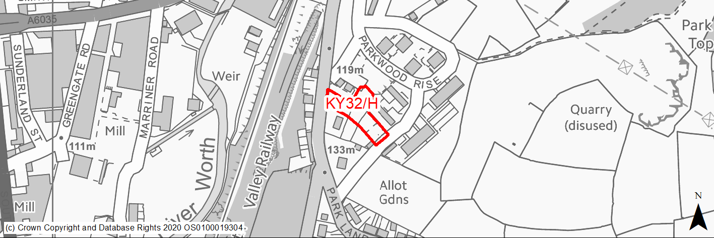
Site location
Principal Town - Keighley
Ward
Keighley East
Site description
The site consists of two parcels of land, one of which an area overgrown with trees whilst the other is former community centre and car park that has been cleared, and is currently used as parking.
Proposed Allocation
Housing
SHLAA referencce
KY/099
Indicative no. dwellings
10
Site area (Gross) (ha)
0.22
Ownership
Private
Delivery timescales
Developable (6-10 years)
Type (PDL/Greenfield)
PDL
Green Belt
No
Flood Zone
Flood Zone 1
Potential site access
The most recent planning application (07/03164/FUL) suggests that the site would be accessed from Parkwood Rise via Broom Street and Wood Street, with a pedestrian access proposed on Park Lane.
Public Transport Accessibility
Bus: The nearest bus stops are located on Parkwood Rise circa 25m and 7m from the eastern boundary of the site. However, they do not appear to be served by a regular services. Other stops are located on Park Lane circa 38m and 45m to the south west of the site. These offer mainly 3 services (occasionally 4 services) per hour towards Keighley (inbound) and 2 services towards Thwaites Brow. There is also a very limited service towards Oxenhope. Services K5, K10 & K15.
Rail: Keighley Railway Station is located around 760m to north of site (in a straight line)/around 800m (via shortest walking route). This offers 4 services per hour towards Skipton, Leeds (2 per hour) and Bradford Forster Square (2 per hour). Also has other limited services to Carlisle and Lancaster/Morecambe.
Sustainability Appraisal
No significant adverse effects have been predicted for the site. As a partial greenfield site, in proximity to woodland, there is the potential for minor effects on biodiversity and local townscape character. The site’s location provides good access to key services and amenities, including shops, jobs, and cultural and recreational areas. The site has excellent access to sustainable transport modes, schools, and health facilities.
Habitats Regulations Assessment
This site falls within 7km of the South Pennine Moors SPA/SAC. A HRA must be undertaken to ensure there are no significant effects on these protected sites. Developments within these zones must comply with Policy SP11; a SPD is being produced to provide further guidance.
Green Belt
N/A – Site not within the Green Belt.
Constraints and Opportunities
• This is a mainly previously developed site within the Keighley built up area, surrounded by residential development. Parts of the site are steeply sloping, with the remainder being level.
• It is within the 7km buffer of the SPA/SAC.
Development considerations
• Design and layout will need to take account of the site's topography.
• Access is available from the surrounding road network, however consideration should be given to impacts on the wider network.
Conclusion/Summary
This is a sustainable site within the Keighley built up area with good access to local services and facilities including a primary school. Further services and facilities as well as transport links are available in Keighley town centre, which is within walking distance. The site will deliver an estimated 10 dwellings.
(2) KY33/H - Parkwood Rise
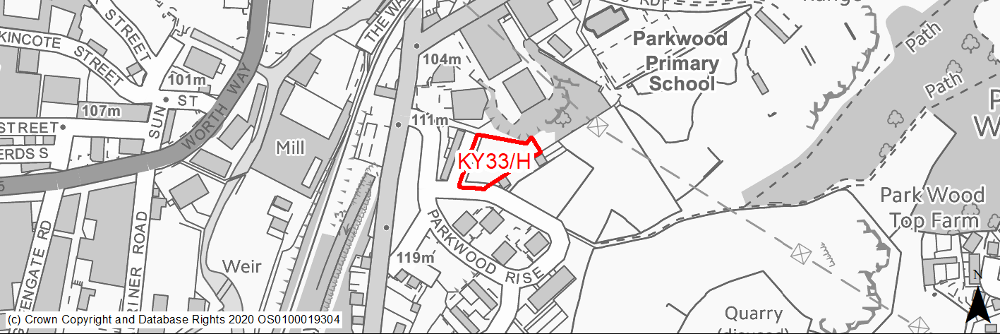
Site location
Principal Town - Keighley
Ward
Keighley East
Site description
The site consists of an overgrown area of land with some tree cover.
Proposed Allocation
Housing
SHLAA referencce
KY/101
Indicative no. dwellings
7
Site area (Gross) (ha)
0.21
Ownership
Private
Delivery timescales
Developable (6-10 years)
Type (PDL/Greenfield)
Greenfield
Green Belt
No
Flood Zone
Flood Zone 1
Potential site access
From Parkwood Rise.
Public Transport Accessibility
Bus: The nearest bus stops with a regular service are located 70m and 80m to the north west of the site on Park Lane. These stops offer 3 services per hour towards Keighley Bus Station (inbound) and Thwaites Brow (2 per hour) and Oakworth (1 per hour). Services K5, K10 & K15.
Rail: Keighley railway station is located around 760m to the north west (in a straight)/around 800m (via quickest walking route). It provides 4 services per hour to Skipton, Leeds (2 per hour) & Bradford (2 per hour). Also has other limited services to Carlisle and Lancaster/Morecambe.
Sustainability Appraisal
No significant adverse effects have been predicted for the site. As a large greenfield site, minor adverse effects have been predicted for most natural environment themed SA Objectives. The site is well located to provide access to services and facilities, including shops, health facilities, and jobs, with particularly good access to schools and sustainable transport modes.
Habitats Regulations Assessment
This site falls within 7km of the South Pennine Moors SPA/SAC. A HRA must be undertaken to ensure there are no significant effects on these protected sites. Developments within these zones must comply with Policy SP11; a SPD is being produced to provide further guidance.
Green Belt
N/A – Site not within the Green Belt.
Constraints and Opportunities
• This is a small, greenfield site within the Keighley built up area, located in a established residential area within reach of the town centre. The northern edge is formed by the top a former quarry face.
• There are a number of trees and shrubs within the site and around its boundaries.
• It is within a Green Infrastructure corridor and the 7km buffer of the SPA/SAC.
Development considerations
• Design and layout should seek to retain boundary trees.
• Assessment required of former quarry face.
• Access available from Parkwood Rise, however consideration should be given to wider highways network to the eastern portion of Keighley caused by bridges at Coney Lane/Park Lane.
Conclusion/Summary
This is a sustainable site within the Keighley built up area with good acces to local services and facilities including a primary school. Further services and facilities as well as transport links are available in Keighley town centre, which is within walking distance. The site will deliver an estimated 7 dwellings.
(2) KY34/H - Former Branshaw Special School, Nashville Street
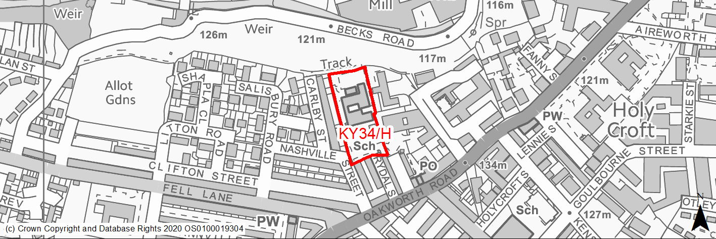
Site location
Principal Town - Keighley
Ward
Keighley West
Site description
The site consists of cleared land that was occupied by the former Branshaw Special School. The school buildings have been demolished.
Proposed Allocation
Housing
SHLAA referencce
KY/125
Indicative no. dwellings
30
Site area (Gross) (ha)
0.52
Ownership
Council
Delivery timescales
Developable (6-10 years)
Type (PDL/Greenfield)
PDL
Green Belt
No
Flood Zone
Flood Zone 1
Potential site access
Access to site is from Nashville Street.
Public Transport Accessibility
Bus: Site located within 400m of high frequency bus corridor (Oakworth Road). Nearest bus stops are located 65m to the south, and 117m to the south east of the site on Oakworth Road. The former provides 4 or 5 services per hour towards Keighley Town Centre/Bus Station, whilst the latter provides 4 or 5 service per hour towards Exley Head and Oakworth. Services K6, K7, K14 & K16.
Rail: Keighley railway station is located around 1.25km to the north east.
Sustainability Appraisal
No significant adverse effects have been predicted for the site. The only minor adverse effects predicted are those related to increases in air pollution and water consumption, which have been predicted at nearly all sites. As a PDL site in the centre of Keighley, residents here would have excellent access to services and amenities, including jobs, shops, and transport options, with particularly good access to schools and health facilities.
Habitats Regulations Assessment
This site falls within 7km of the South Pennine Moors SPA/SAC. A HRA must be undertaken to ensure there are no significant effects on these protected sites. Developments within these zones must comply with Policy SP11; a SPD is being produced to provide further guidance.
Green Belt
N/A – Site not within the Green Belt.
Constraints and Opportunities
• This is a previously developed site within the Keighley built up area, in an established residential area. It was formerly occupied by school buildings, which have been demolished. It provides an opportunity to regenerate the site.
• Within a Green Infrastructure corridor and 7km buffer zone of the SPA/SAC. Priority habitat adjacent to the site.
Development considerations
• Access (vehicular and pedestrain) available from Nashville Street.
• Mitigate any surface water flooding or drainage issues will be required.
Conclusion/Summary
This is a level, previously developed site, sustainably located within the Keighley built up area. It is close to local services and facilities including shops (Fell Lane local centre), park (Lund Park) and a primary school, as well as main public transport corridor. The town centre is also a short distance from the site. It can deliver an estimated 30 dwellings.
(21) KY35/H - Land Off Golden View Drive, Thwaites
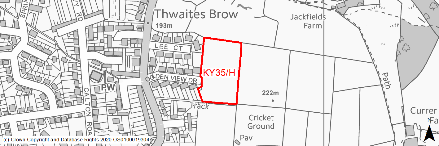
Site location
Principal Town - Keighley
Ward
Keighley East
Site description
The site consists of a sloping, single agricultural field located to the east of an existing residential area and bounded by dry stone walling.
Proposed Allocation
Housing
SHLAA referencce
KY/133
Indicative no. dwellings
30
Site area (Gross) (ha)
0.98
Ownership
Private
Delivery timescales
Developable (11-15 years)
Type (PDL/Greenfield)
Greenfield
Green Belt
Yes
Flood Zone
Flood Zone 1
Potential site access
Existing field access available from Golden View Drive.
Public Transport Accessibility
Bus: The nearest bus stop is located around 140m to north west on Thwaites Brow Road. This is served by an hourly services towards Keighley town centre and bus station. Service K5.
Rail: Keighley railway station is located around 1.4km to the north west.
Sustainability Appraisal
The site could deliver a major positive effect for residents on the health SA Objective as a result of being within the target distances for all necessary health facilities.
Minor positive effects were predicted for most other socio-economic themed SA Objectives due to the benefits of new residential development for the local economy as well as the location of the site in relation to transport links, local amenities and education facilities.
No major adverse effects have been predicted for the site, but minor adverse effects were predicted for a range of natural environment themed SA Objectives, primarily as a result of the impacts of new development on a 100% greenfield and Green Belt site. Being on raised ground atop a small hill, the site would likely be visible from a distance and as such development at the site could impact the landscape and alter the local character.
Habitats Regulations Assessment
This site falls within 7km of the South Pennine Moors SPA/SAC. A HRA must be undertaken to ensure there are no significant effects on these protected sites. Developments within these zones must comply with Policy SP11; a SPD is being produced to provide further guidance.
Green Belt
Based on planning judgement the site has a major potential impact on the Green Belt.
• The site is located in a moderate Green Belt parcel
• The site makes a moderate contribution to the purposes of including land in the Green Belt.
• The site has a major potential for sprawl and would have a major impact on openness.
• There is no opportunity to create a stronger Green Belt boundary than the existing boundary.
Constraints and Opportunities
• This is a greenfield site within the Green Belt, adjacent to the settlement boundary for Keighley (Thwaites Brow). The site specific Green Belt assessment indicates that it has a major potential impact.
• This is an elevated site which will have a landscape and visual impacts.
• The site is located within the 7km buffer of the SPA/SAC.
Development considerations
• Provision of compensatory improvements to the surrounding Green Belt will be required.
• Landscape and visual impact assessment required to identifiy and mitigate/reduce impacts through sensitive design and layout.
• Appropriate boundary treatments will required.
• Consideration of wider issue with highways access to the eastern portion of Keighley caused by bridges at Coney Lane/Park Lane.
• Access available of adjacent highway network.
Conclusion/Summary
This is a sustainably located Green Belt site adjoining the settlement boundary, close to existing facilities and services including a public house and medical centre. It will deliver an estimated 30 dwellings, but will need a sensitive design and layout to mitigate the landscape impact and due consideration being given to the impacts of development in the eastern portion of Keighley on the wider highway network.
(19) KY36/H - Long Lee Lane
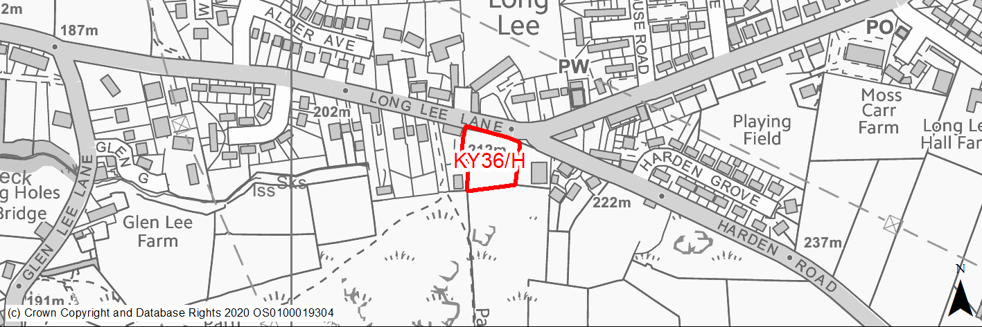
Site location
Principal Town - Keighley
Ward
Keighley East
Site description
The site consists of a field and existing resdential. It is predominately level, but slopes steeply upwards towards the rear.
Proposed Allocation
Housing
SHLAA referencce
KY/134A
Indicative no. dwellings
13
Site area (Gross) (ha)
0.24
Ownership
Private
Delivery timescales
Developable (6-10 years)
Type (PDL/Greenfield)
Greenfield
Green Belt
Yes
Flood Zone
Flood Zone 1
Potential site access
Potential access from Harden Road or Long Lee Lane. Key issue is the proximity of the site to junction Long Lee Lane/Harden Road.
Public Transport Accessibility
Bus: The nearest bus stops are located around 330m to the north east on Long Lee Lane. These provide an hourly service in each direction between Keighley Bus Station and Thwaites Brow (Service K5).
Rail: Keighley railway station is located around 1.2km to the north west.
Sustainability Appraisal
The site could deliver a major positive effect for residents on the health SA Objective as a result of being within the target distances for all necessary health facilities.
A significant adverse effect arises from the band of high surface water flood risk running through the centre of the site, which would be difficult to avoid given the relatively small size of the site.
Minor positive effects were predicted for some socio-economic themed SA Objectives due to the benefits of new residential development for the local economy as well as the location of the site in relation to transport links and education facilities.
Minor adverse effects have been predicted for a range of natural environment themed SA Objectives, primarily as a result of the impacts of new development on a 100% greenfield and Green Belt site. Hog Holes Beck is 25m west of the site, so consideration around protecting water quality would be required.
Habitats Regulations Assessment
This site falls within 7km of the South Pennine Moors SPA/SAC. A HRA must be undertaken to ensure there are no significant effects on these protected sites. Developments within these zones must comply with Policy SP11; a SPD is being produced to provide further guidance.
Green Belt
Based on planning judgement the site has a moderate potential impact on the Green Belt.
• The site is located within a moderate Green Belt parcel.
• The site makes a low contribution to the purposes of including land in the Green Belt.
• The site has a moderate potential for sprawl and would have a moderate impact on openness.
• There are no limited opportunities to create a stronger Green Belt boundary than the existing boundary.
Constraints and Opportunities
• This is a small, mainly level greenfield site within the Green Belt, adjacent to the settlement boundary for Keighley. The site specific Green Belt assessment indicates that it has a moderate potential impact. It is enclosed by residential development of two sides, with a slope to the south.
• A watercourse is present adjacent to the western boundary.
• It is within the 7km buffer of the SPA/SAC
Development considerations
• Provision of compensatory improvements to the surrounding Green Belt will be required.
• Access available from Harden Road or Long Lee Lane, however proximity to junction will be need to be considered.
• Consideration of wider issue with highways access to the eastern portion of Keighley caused by bridges at Coney Lane/Park Lane.
• Appropriate screening and planting is required to reduce impact of built development along southern boundary of the site.
Conclusion/Summary
This is a sustainably located Green Belt site adjoining the settlement boundary, close to existing facilities and services including a primary school and medical centre. It will deliver an estimated 13 dwellings, but will require due consideration being given to the impacts of development in the eastern portion of Keighley on the wider highway network.
(2) KY37/HC - Former Ingrow Corn Mill
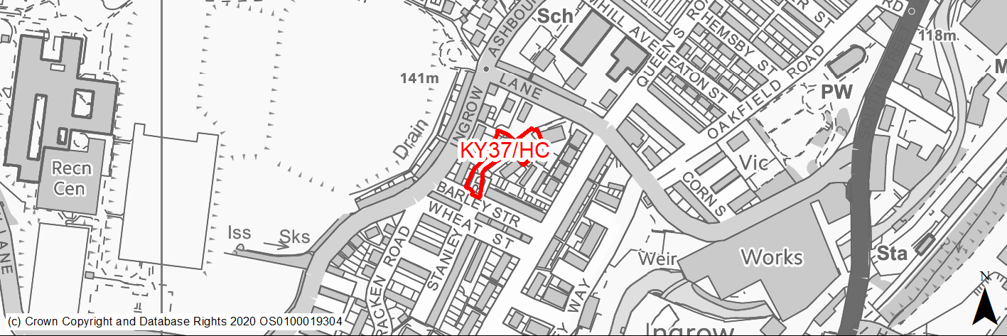
Site location
Principal Town - Keighley
Ward
Keighley West
Site description
This site consists of an uneven area of land formerly used for resident parking.
Proposed Allocation
Housing
SHLAA referencce
KY/136
Indicative no. dwellings
9
Site area (Gross) (ha)
0.13
Ownership
Private
Delivery timescales
Developable (6-10 years)
Type (PDL/Greenfield)
PDL
Green Belt
No
Flood Zone
Flood Zone 1
Potential site access
The site would be accessed off Barley Street.
Public Transport Accessibility
Public transport accessibility has been taken into account as part of the planning application process.
Sustainability Appraisal
The site could deliver major positive effects for residents on both the health and education SA Objectives as a result of being within the target distances for all necessary health facilities and centres for primary and secondary education.
Minor positive effects were predicted for most other socio-economic themed SA Objectives due to the benefits of new residential development for the local economy as well as the location of the site in relation to transport links, local amenities and employment areas.
No major adverse effects have been predicted for the site, but minor adverse effects were predicted for a range of natural environment themed SA Objectives, primarily as a result of the impacts of development on a partially greenfield site that is situated entirely within Natural England’s GI corridor.
Habitats Regulations Assessment
This site falls within 7km of the South Pennine Moors SPA/SAC a HRA must be undertaken to ensure there are no significant effects on these protected sites in terms of recreational pressures. Developments within these zones must comply with Policy SP11; an SPD is being produced to provide further guidance.
Green Belt
N/A – Site not within the Green Belt.
Constraints and Opportunities
• Relevant constraints and opportunities have been considered as part of the planning application process.
Development considerations
• Relevant development considerations have been taken into account as part of the planning application process.
Conclusion/Summary
This site has outline planning permission for 9 dwellings (13/04597/OUT approved 29.04.14).
(1) KY38/H - Worthville Farm, Dawson Road
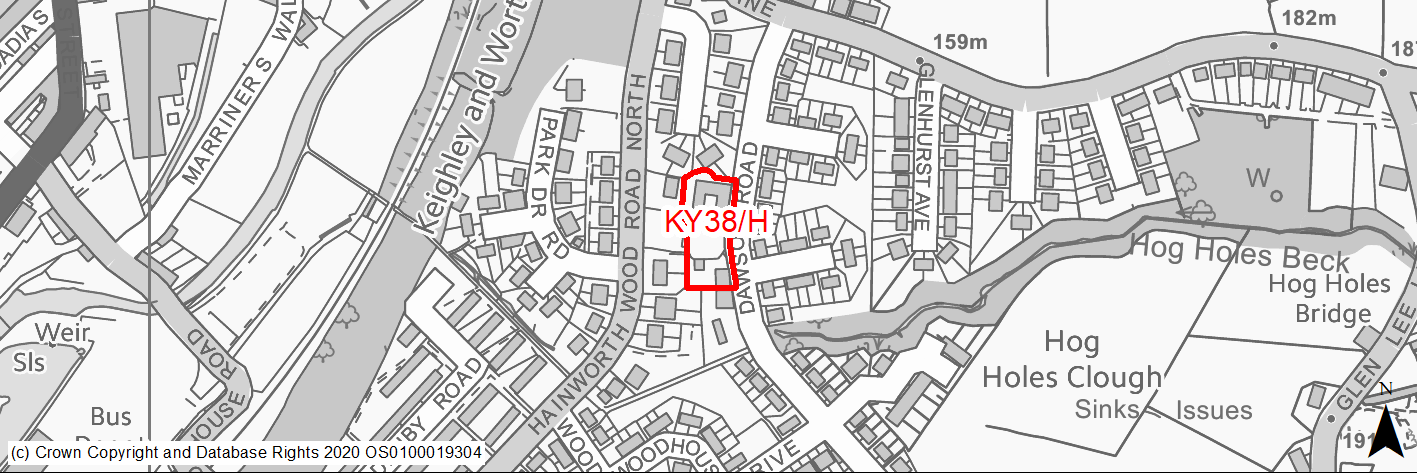
Site location
Principal Town - Keighley
Ward
Keighley East
Site description
The site consists of land and buildings including workshops occupied by an architectural technologist business as well as a dwelling and garden.
Proposed Allocation
Housing
SHLAA referencce
KY/138
Indicative no. dwellings
10
Site area (Gross) (ha)
0.22
Ownership
Private
Delivery timescales
Developable(6-10 years)
Type (PDL/Greenfield)
PDL
Green Belt
No
Flood Zone
Flood Zone 1
Potential site access
Access from Dawson Avenue.
Public Transport Accessibility
Bus: Six bus stops are identified within 400m of the site at: Hainworth Wood Road South (close to junction with Worthville Close and close to junction with Woodhouse Avenue). These stops offer 1 service per hour towards Keighley Town Centre/Bus Station (inbound) and Oakworth (outbound) as well as a very limited service to/from Oxenhope. Park Lane (close to Glenhurst Avenue). These stops offer 2 services per hour towards Keighley Town Centre/Bus Station and Thwaites Brow as well as a very limited service to/from Oxenhope. Services K5, K10 & K15.
Rail: Keighley railway station is located 1km to the north.
Sustainability Appraisal
As a brownfield site KY/138 could be an efficient use of land, depending on the impacts on the MSA it is within. No significant adverse effects have been predicted. There could potentially be adverse effects on the nearby Ancient Woodland and LWS. Development at the site could improve the local character and vitality. Residents here would have good access to key services and amenities, as well as jobs, cultural spaces and transport options, with particularly good access to schools.
Habitats Regulations Assessment
This site falls within 7km of the South Pennine Moors SPA/SAC. A HRA must be undertaken to ensure there are no significant effects on these protected sites. Developments within these zones must comply with Policy SP11; a SPD is being produced to provide further guidance.
Green Belt
N/A – Site not within the Green Belt.
Constraints and Opportunities
• This is a previously developed site within the Keighley built up area, in an established residential area. It consists of a mix of business and residential uses. Historically it was part of a farm.
• Access is available from adjacent street.
• Within a Green Infrastructure corridor.
• Public transport is available, but at the required frequency.
• Within 7km buffer of SPA/SAC.
Development considerations
• Consideration of existing building on the site.
• Consideration of wider issue with highways access to the eastern portion of Keighley caused by bridges at Coney Lane/Park Lane.
• Site access is available from Dawson Avenue.
Conclusion/Summary
This is a previously developed site, sustainably located within the Keighley built up area, in an established residential area. It will deliver an estimated 10 dwellings, however this will be subject to due consideration being given to the impacts of development in the eastern portion of Keighley on the wider highway network.
(3) KY39/H - Bradford Road/Bronte Street
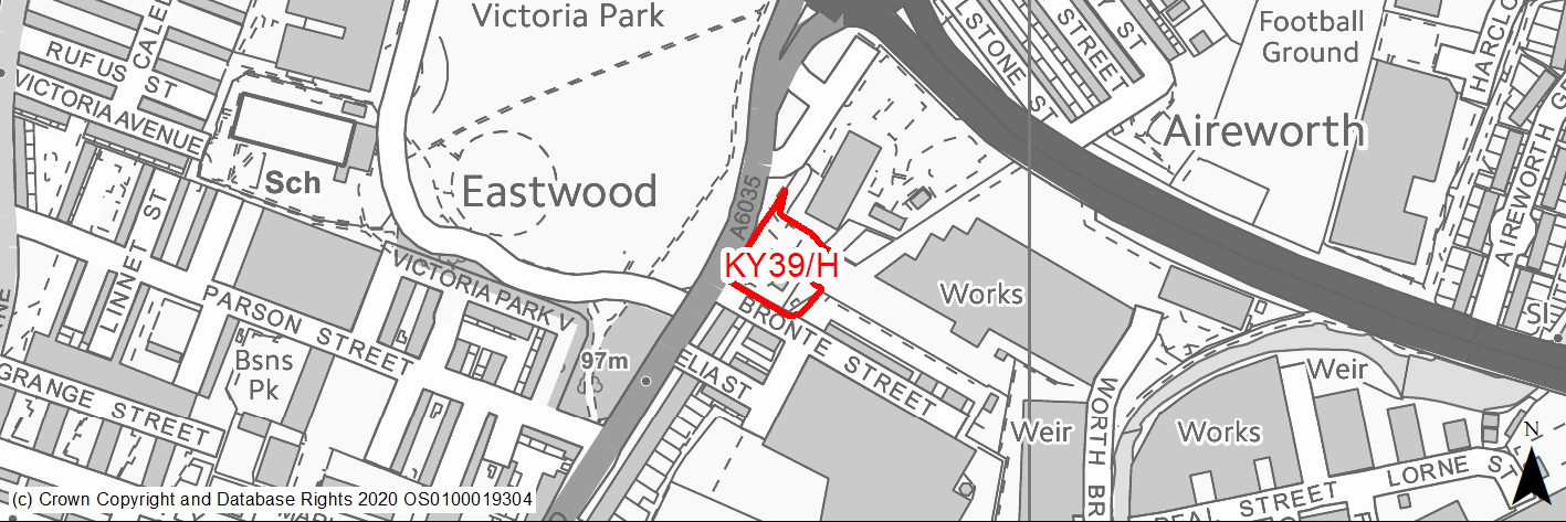
Site location
Principal Town - Keighley
Ward
Keighley Central
Site description
The site consists of a former car sales showroom and forecourt.
Proposed Allocation
Housing
SHLAA referencce
KY/158
Indicative no. dwellings
16
Site area (Gross) (ha)
0.21
Ownership
Private
Delivery timescales
Developable (6-10 years)
Type (PDL/Greenfield)
PDL
Green Belt
No
Flood Zone
Flood Zone 1
Potential site access
Existing access is available at the north west corner of the site from Bradford Road.
Public Transport Accessibility
Bus: The nearest bus stops are located circa 45m and 75m to the south west of site on Bradford Road. These provide 6 services per hour towards Bradford (outbound) and Keighley Bus Station (in bound). There is also more limited services from Keighley to Cullingworth (and return) which operates every 2 hours each way. Services 662 & K17.
Rail: Keighley Railway Station is located around 500m to the south west of site (in a straight line)/around 480m (via shortest walking route). It provides 4 services per hour to Skipton, Leeds (2 per hour) & Bradford (2 per hour). Also has other limited services to Carlisle and Lancaster/Morecambe.
Sustainability Appraisal
No significant adverse effects predicted for any SA Objective. As a PDL plot it would be an efficient use of land, depending on the potential impacts on the MSA. The site includes TPO woodland and it is unclear how this may be affected by development here. Residents here would have good access to key services and amenities, as well as jobs, cultural spaces, and transport options, with particularly good access to schools.
Habitats Regulations Assessment
This site falls within 2.5km of the South Pennine Moors SPA/SAC a HRA must be undertaken to ensure there are no significant effects on these protected sites in terms of impact on supporting habitat which might be functionally linked to the SPA and recreational pressures. Developments within these zones must comply with Policy SP11; an SPD is being produced to provide further guidance.
Green Belt
N/A – Site not within the Green Belt.
Constraints and Opportunities
• This is a previously developed site within the Keighley built up area. It was formerly used for car sales and repairs and consists of level, made ground.
• Victoria Park (Grade II Listed Building) is opposite, whilst there are areas of TPO woodland on and adajcent to the site.
• It is located on a high frequency bus route and within walking distance of Keighley railway station as well as the town centre and local facilities.
• Access is from Bradford Road.
• Within Green Infrastructure corridor and within 2.5km buffer of the SPA/SAC.
Development considerations
• Presence of TPO trees and woodland.
• Identification of most appropriate access point.
• Identify and mitigate any impact on Listed Building (Victoria Park).
• Identify and mitigate potential land contamination resulting from previous use.
Conclusion/Summary
This is a sustainble site within the existing built up area of Keighley, within good access to local services as well as the town centre. It represents an opportunity bring a previously developed site back into beneficial use. It will deliver an estimated 16 dwellings.
(13) KY40/H - The Bungalow, Harden Road, Long Lee

Site location
Principal Town - Keighley
Ward
Keighley East
Site description
The site consists of sloping agricultural field. It is crossed from north to south by a local electricity distribution line.
Proposed Allocation
Housing
SHLAA referencce
KY/159A
Indicative no. dwellings
6
Site area (Gross) (ha)
0.21
Ownership
Private
Delivery timescales
Developable (6-10 years)
Type (PDL/Greenfield)
Greenfield
Green Belt
Yes
Flood Zone
Flood Zone 1
Potential site access
Potential access from Harden Road. Potential issue with gradients.
Public Transport Accessibility
Bus: the nearest bus stops are located around 300m to the north east on Long Lee Lane. These provide an hourly service in each direction between Keighley Bus Station and Thwaites Brow (Service K5).
Rail: Keighley railway station is located around 1.3km to the north west.
Sustainability Appraisal
The site could deliver a major positive effect for residents on the health SA Objective as a result of being within the target distances for all necessary health facilities.
Minor positive effects were predicted for most socio-economic themed SA Objectives due to the benefits of new residential development for the local economy as well as the location of the site in relation to transport links, education facilities and employment areas.
No major adverse effects have been predicted for the site, but minor adverse effects were predicted for a range of natural environment themed SA Objectives, primarily as a result of the impacts of new development on a 100% greenfield and Green Belt site.
Habitats Regulations Assessment
This site falls within 7km of the South Pennine Moors SPA/SAC. A HRA must be undertaken to ensure there are no significant effects on these protected sites. Developments within these zones must comply with Policy SP11; a SPD is being produced to provide further guidance.
Green Belt
Based on planning judgement the site has a moderate potential impact on the Green Belt.
• The site is located within a moderate Green Belt parcel.
• The site makes a moderate contribution to the purposes of including land in the Green Belt.
• The site has a moderate potential for sprawl and would have a moderate impact on openness.
• There are no limited opportunities to create a stronger Green Belt boundary than the existing boundary.
Constraints and Opportunities
• This is a small, steeply greenfield site within the Green Belt, adjacent to the settlement boundary for Keighley. The site specific Green Belt assessment indicates that it has a moderate potential impact. It is enclosed by residential development of two sides, with a slope to the south.
• An local electricity distribution line runs through the site.
• It is within the 7km buffer of the SPA/SAC.
Development considerations
• Provision of compensatory improvements to the surrounding Green Belt will be required.
• Access available from Harden Road.
• Consideration of wider issue with highways access to the eastern portion of Keighley caused by bridges at Coney Lane/Park Lane.
• Appropriate screening and planting is required to reduce impact of built development along southern boundary of the site.
Conclusion/Summary
This is a sustainably located Green Belt site adjoining the settlement boundary, close to existing facilities and services including a primary school and medical centre. It will deliver an estimated 6 dwellings, but will require due consideration being given to the impacts of development in the eastern portion of Keighley on the wider highway network.
(2) KY42/HC - Land off Ryan Grove, Braithwaite
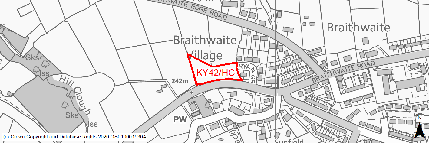
Site location
Principal Town - Keighley
Ward
Keighley West
Site description
The site consists of agricultural land, which is currently used for grazing.
Proposed Allocation
Housing
SHLAA referencce
KY/164A
Indicative no. dwellings
6
Site area (Gross) (ha)
0.37
Ownership
Private
Delivery timescales
Developable (6-10 years)
Type (PDL/Greenfield)
Greenfield
Green Belt
No
Flood Zone
Flood Zone 1
Potential site access
Access from Ryan Grove onto Braithwaite Road.
Public Transport Accessibility
Bus: The nearest bus stops are located to the south of the site on Braithwaite Road. One is immediately adjacent to the south west corner of the site, whilst the other is 58m to the south west. These offer 2 (occasionally 3) services per hour in each direction towards Keighley Bus Station (eastbound) and Laycock (westbound). Service K1.
Rail: Keighley railway station is 2.6km to east.
Sustainability Appraisal
Minor positive effects were predicted for a range of socio-economic themed SA Objectives due to the benefits of new residential development for the local economy as well as the location of the site in relation to transport links, health facilities and education centres, although residents may need to travel beyond the target distance to access services and amenities.
No major adverse effects have been predicted for the site, but minor adverse effects were predicted for a range of natural environment themed SA Objectives, primarily as a result of the impacts of new development on a 100% greenfield site. In particular, the site is 10m north of the Braithwaite Conservation Area; development at this open greenfield site would be likely to adversely alter the setting of this sensitive historic area.
Habitats Regulations Assessment
This site falls within 7km of the South Pennine Moors SPA/SAC. A HRA must be undertaken to ensure there are no significant effects on these protected sites. Developments within these zones must comply with Policy SP11; a SPD is being produced to provide further guidance.
Green Belt
N/A – Site not within the Green Belt.
Constraints and Opportunities
• This is a greenfield site located within the settlement boundary for Keighley on the western edge of the settlement. It adjoins the west of Ryan Grove, a residential cul de sac, and is adjacent to (north of) the Braithwaite Conservation Area. It is currently used for animal grazing. The western portion of the site slopes steeply upwards towards the western and northern boundaries.
• Public transport access is limited.
• It is within the 7km buffer of the SPA/SAC.
Development considerations
• Key development considerations have been addressed as part of the planning application. Details of appearance and landscaping will be addressed through a Reserved Matters application (to be submitted no later than 3 years from the date of the outline planning permission - by 27.06.2022).
Conclusion/Summary
The site benefits from the outline planning permission for residential development. Appearance and landscaping will be addressed through the submission of a Reserved Matters application.
(1) KY43/H - Grange Street
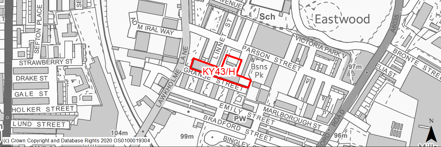
Site location
Principal Town - Keighley
Ward
Keighley Central
Site description
The site consists of a number derelict buildings that were previouly used as museum and a variety of commercial and business uses. Parts of the site have been cleared.
Proposed Allocation
Housing
SHLAA referencce
KY/167
Indicative no. dwellings
25
Site area (Gross) (ha)
0.34
Ownership
Mixed
Delivery timescales
Developable (6-10 years)
Type (PDL/Greenfield)
PDL
Green Belt
No
Flood Zone
Flood Zone 1
Potential site access
Site access is from Lawkholme Road via Grange Street.
Public Transport Accessibility
Bus: The nearest bus stops are located on Lawkholme Road circa 35m form the western edge of the site. The offer a limited number of services (2 hourly frequency) to Cullingworth and Keighley Town Centre. It should be noted that this service is currently diverted and does not serve these stops. The next closest stops are adajcent to the junction of Lawkholme Road and Alice Street around 230m to the south west of the site.
Rail: Keighley railway station is located circa 360m to the south east of the site (in a straight line)/640m via the quickest walking route. It provides 4 services per hour to Skipton, Leeds (2 per hour) & Bradford (2 per hour). Also has other limited services to Carlisle and Lancaster/Morecambe.
Sustainability Appraisal
No significant adverse effects predicted for any SA Objective. As a PDL plot it would be an efficient use of land, depending on the potential impacts on the MSA, and would be an opportunity to achieve biodiversity net gains and improvements to the local character. Residents here would have good access to key services and amenities, as well as jobs, cultural spaces, and transport options, with particularly good access to schools.
Habitats Regulations Assessment
This site falls within 7km of the South Pennine Moors SPA/SAC. A HRA must be undertaken to ensure there are no significant effects on these protected sites. Developments within these zones must comply with Policy SP11; a SPD is being produced to provide further guidance.
Green Belt
N/A – Site not within the Green Belt.
Constraints and Opportunities
• This is a previously developed site within the Keighley built up area, in an established residential area. It consists of a number of derelict buildings and provides an opportunity to support regeneration in this area. The site is located close to employment opportunities and local services.
• It is within a Green Infrastructure corridor, whilst a TPO woodland is present.
• Within 7.km buffer of the SPA/SAC.
Development considerations
• Identification and mitigation of any potential contamination associated with previous uses.
• Opportunities to improve adjacent play area/open space and pedestrian connectivity within the surrounding area.
• Consideration of impacts on TPO woodland.
• Vehicular access is available from Lawkholme Lane via Grange Street.
Conclusion/Summary
This is a previously developed site, sustainably located within the Keighley built up area, in an established residential area. It is close to local services and facilities including shops, community centres and a school as well as within walking distance of Keighley railway station and the town centre. In addition, it represents an opportunity to regenerate a derelict site and improve existing open and pedestrian connectivity. It will deliver an estimated 25 dwellings.
(2) KY44/H - Parson Street
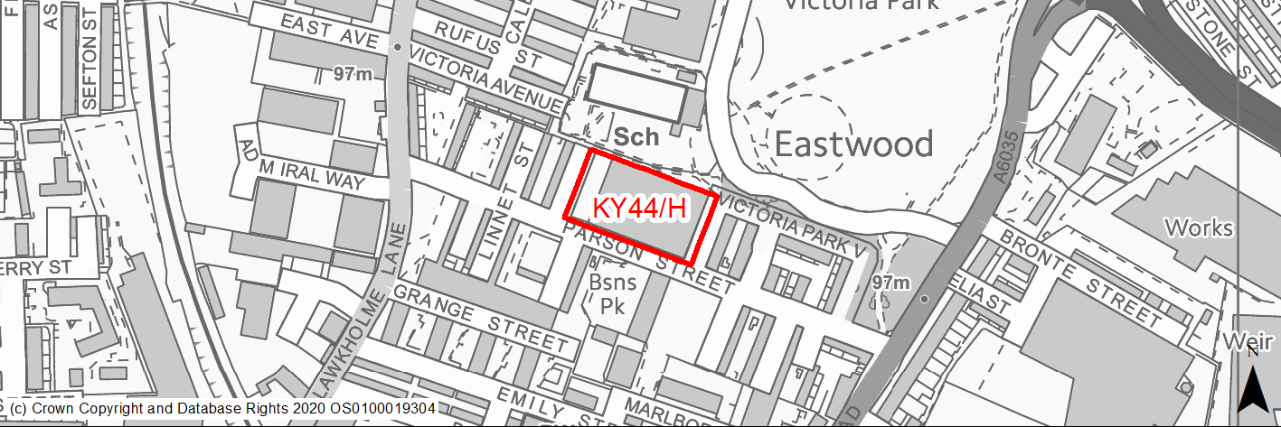
Site location
Principal Town - Keighley
Ward
Keighley Central
Site description
The site consists of a former mill building and area of open land that is occupied by a number of businesses and open storage.
Proposed Allocation
Housing
SHLAA referencce
KY/172
Indicative no. dwellings
35
Site area (Gross) (ha)
0.49
Ownership
Private
Delivery timescales
Developable (6-10 years)
Type (PDL/Greenfield)
PDL
Green Belt
No
Flood Zone
Flood Zone 1
Potential site access
Site access from Parson Street.
Public Transport Accessibility
Bus: There are four bus stops within 400m of the site on Lawkholme Lane and Bradford Road. The are former are cloest (circa 120m) but do not offer a sufficiently frequent services (service currently being diverted), the latter stops are around 180m to the east. These stops provide 6 services per hour towards Bradford (outbound) and Keighley Bus Station (inbound). There is also a limited service between Keighley and Cullingworth.
Rail: Keighley railway station is located circa 400m to the south east of the site (in a straight line)/640m via the quickest walking route. This offers 4 services per hour towards Skipton, Leeds (2 per hour) and Bradford (2 per hour).
Sustainability Appraisal
The site could deliver major positive effects for residents on both the health and transport SA Objectives as a result of being within the target distances for all necessary health facilities, as well as bus stops and a railway station.
Minor positive effects were predicted for most socio-economic themed SA Objectives due to the benefits of new residential development for the local economy as well as the location of the site in relation to local services and amenities, and education facilities.
As a PDL site, there are opportunities here for achieving biodiversity net gains and enhancing the local townscape character, depending on the implementation of the development.
There are no major adverse effects predicted for the site, and the only minor adverse effects are related to increases in air pollution and water consumption, which have been predicted at nearly all sites.
Habitats Regulations Assessment
This site falls within 2.5km of the South Pennine Moors SPA/SAC a HRA must be undertaken to ensure there are no significant effects on these protected sites in terms of impact on supporting habitat which might be functionally linked to the SPA and recreational pressures. Developments within these zones must comply with Policy SP11; an SPD is being produced to provide further guidance.
Green Belt
N/A – Site not within the Green Belt.
Constraints and Opportunities
• This is a previously developed site within the Keighley built up area, in an established mixed residential and commercial area. It is currently occupied by a number of businesses. Local services including a primary school, community hall/leisure centre and park are adjacent, whilst a public right of way runs along the northern boundary.
• The site is adjacent to Victoria Park (Grade II Listed) and within a Green Infrastructure corridor.
• It is also within the 2.5km and 7km buffers of the SPA/SAC.
Development considerations
• Design will be required to considered the setting of the adjacent Listed Park and ensure that contributes to conservation and enhancement.
• Contaminated land assessment will be required to identify and mitigate potential impacts from previous/current uses.
• Bird survey will required due to its location with the 2.5km buffer of the SPA.
• Vehicular access available from Parson Street.
• Pedestrian access available for Victoria Park.
Conclusion/Summary
This is a previously developed site, sustainably located within the Keighley built up area, in an established mixed residential and commercial area. It is immediately adjacent to local services and facilities including a primary school, community hall, leisure and park as well as within walking distance of Keighley railway station and the town centre. Frequent public transport services are available on Bradford Road. It will deliver an estimated 35 dwellings.
(1) KY45/HC - Former Mortuary, Skipton Road
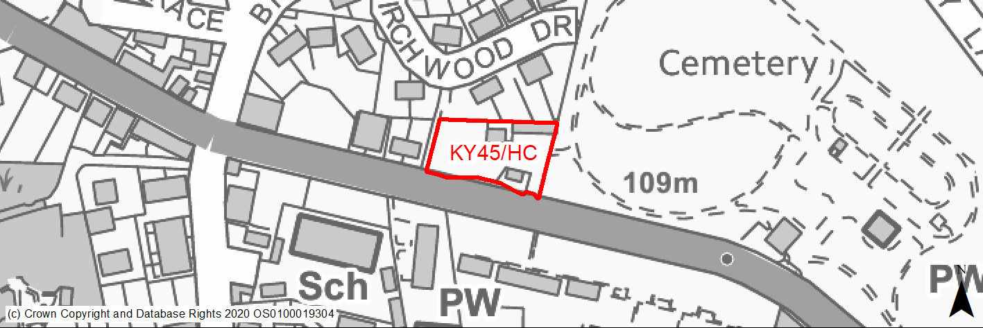
Site location
Principal Town - Keighley
Ward
Keighley Central
Site description
This site consists of the former mortuary buildings and surrounding land.
Proposed Allocation
Housing
SHLAA referencce
KY/175
Indicative no. dwellings
5
Site area (Gross) (ha)
0.15
Ownership
Private
Delivery timescales
Developable (6-10 years)
Type (PDL/Greenfield)
PDL
Green Belt
No
Flood Zone
Flood Zone 1
Potential site access
The site would be accessed off Skipton Road.
Public Transport Accessibility
Public transport accessibility has been taken into account as part of the planning application process.
Sustainability Appraisal
A major adverse effect has been predicted for the cultural heritage SA objective due to the eastern perimeter of the site being adjacent to Utley Cemetery, a Grade II Registered Park/Garden. Development at this open vacant plot would be likely to alter the setting of this highly sensitive heritage asset/historic area.
Minor positive effects were predicted for most socio-economic themed SA Objectives due to the benefits of new residential development for the local economy as well as the location of the site in relation to transport links, education facilities and employment areas.
As a greenfield site adjoining deciduous woodland priority habitat, the development has been predicted to result in minor adverse effects on most natural environment themed SA Objectives.
Habitats Regulations Assessment
This site falls within 7km of the South Pennine Moors SPA/SAC a HRA must be undertaken to ensure there are no significant effects on these protected sites in terms of recreational pressures. Developments within these zones must comply with Policy SP11; an SPD is being produced to provide further guidance.
Green Belt
N/A – Site not within the Green Belt.
Constraints and Opportunities
• Relevant constraints and opportunities have been considered as part of the planning application process.
Development considerations
• Relevant development considerations have been taken into account as part of the planning application process.
Conclusion/Summary
This site has outline planning permission for 5 dwellings (17/04999/OUT approved 14.06.18).
(2) KY46/H - Land at Woodville Road
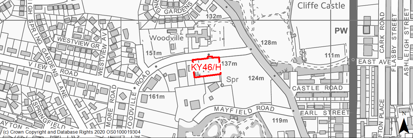
Site location
Principal Town - Keighley
Ward
Keighley Central
Site description
The site consists of an area of unused land within the Keighley built up area. It was historically used by a tennis club. Part of the tennis court fencing and pavilion are still in existence.
Proposed Allocation
Housing
SHLAA referencce
KY/182
Indicative no. dwellings
7
Site area (Gross) (ha)
0.22
Ownership
Private
Delivery timescales
Deliverable (0-5 years)
Type (PDL/Greenfield)
Greenfield
Green Belt
No
Flood Zone
Flood Zone 1
Potential site access
From Woodville Road. The site would not impose significant extra traffic on the network and the access emerges at a point with good visibility.
Public Transport Accessibility
Bus: The nearest bus stops with a frequent service are located circa 300m to east of the site on Skipton Road as well as 140m to the north on Spring Gardens Lane and 150m to the south east at the junction of Spring Gardens Lane & Castle Road. The Skipton Road stops offer 6 services per hour day in each direction towards Keighley (southbound) and Burnley (2 per hour), Skipton (2 per hour), Ilkley (1 per hour) and Leeds Bradford Airport (1 per hour) (northbound) - Services 62, 66 & M4. The Spring Gardens Lane stops offers a limited service between Keighley and Silsden - Service 903.
Rail: Keighley railway station is located around 960m to the south east.
Sustainability Appraisal
See individual Sustainability Appraisal site comment in the accompanying report.
Habitats Regulations Assessment
This site falls within 7km of the South Pennine Moors SPA/SAC. A HRA must be undertaken to ensure there are no significant effects on these protected sites. Developments within these zones must comply with Policy SP11; a SPD is being produced to provide further guidance.
Green Belt
N/A – Site not within the Green Belt.
Constraints and Opportunities
• This is an unused site within the built up area of Keighley that was previously occupied by a tennis club.
• It is located within an area that consists of a mix of residential and parkland.
• It is within the Devonshire Park and Cliffe Castle Conservation Area.
• It is adjacent to an area of open space and is within a Green Infrastructure corridor.
• Mature trees are present along its boundaries.
• It is within the 7km buffer of the SPA/SAC.
• Access is available from Woodville Road.
• The site has planning permission for the construction of seven bungalows – granted in June 2020.
Development considerations
• Sensitive design will be required in order to ensure that development reflects the site’s location within a Conservation Area.
Conclusion/Summary
This is a sustainable site within the Keighley built up area with good access to local services and facilities including a secondary school and parks. Frequent public transport services are available within its vicinity, whilst the town centre is within walking distance. It has planning permission and will deliver 7 dwellings (bungalows). It is expected that the development will be delivered in line with conditions attached to the granted of planning permission.
(1) KY47/H - Former Site of Sandbeds Methodist Church, Swine Lane
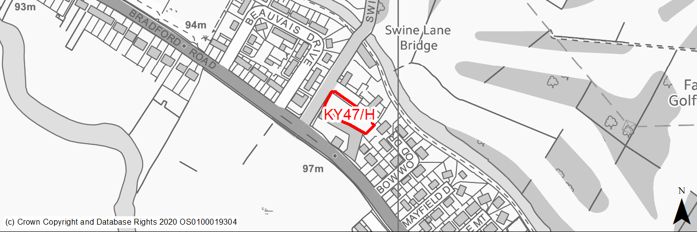
Site location
Principal Town - Keighley
Ward
Keighley East
Site description
The site consists of an area of unused land within the Riddlesden/Sandbeds area of the Keighley. It was previously occupied by the Sandbeds Methodist Church, which was demolished a number of years ago. It is currently vacant and overgrown.
Proposed Allocation
Housing
SHLAA referencce
KY/183
Indicative no. dwellings
8
Site area (Gross) (ha)
0.18
Ownership
Private
Delivery timescales
Deliverable (0-5 years)
Type (PDL/Greenfield)
PDL
Green Belt
No
Flood Zone
Flood Zone 1
Potential site access
From Swine Lane.
Public Transport Accessibility
Bus: The nearest bus stops with a frequent service are located 85m and 90m to south east and west of the site on Bradford Road. Other stops are located immediately adjacent to the site on Swine Lane. The Bradford Road stops offer between 5 or 6 services per hour towards Bingley, Shipley and Bradford (eastbound) and between 5 & 7 services per hour towards Keighley (westbound) - Services 662 & K17. The Swine Lane stops offer a limited service between Keighley and Cullingworth (and return) via East Morton & Bingley - Services K13, K17 & K19.
Rail: Crossflatts railway station is located around 2km to the south east, whilst Keighley railway station is 2.4km to the south west.
Sustainability Appraisal
See individual Sustainability Appraisal site comment in the accompanying report.
Habitats Regulations Assessment
This site falls within 2.5km of the South Pennine Moors SPA/SAC a HRA must be undertaken to ensure there are no significant effects on these protected sites in terms of impact on supporting habitat which might be functionally linked to the SPA and recreational pressures. Developments within these zones must comply with Policy SP11; an SPD is being produced to provide further guidance.
Green Belt
N/A – Site not within the Green Belt.
Constraints and Opportunities
• This is an unused site within the Riddlesden/Sandbeds area of the Keighley built up area that was previously occupied by a church. As such, it is previously developed land.
• It is located within a primarily residential area, although there some uses immediately adjacent to the southern boundary of the site.
• It is located with Flood Zone 1.
• Potential for surface water flooding identified within the centre of the site and adjacent to the southern boundary.
• It is within the 2.5km buffer of the SPA/SAC.
• Access is available from Swine Lane.
• The site has planning permission for the construction of eight dwellings – granted in December 2020.
Development considerations
• Appropriate design and layout will be required to ensure suitable access and parking provision as well as to address any potential amenity impacts.
• A contaminated land study will be required.
• An ecological survey will be required.
• Appropriate planting and screening will be required to address the presence of the adjacent employment use.
Conclusion/Summary
This is a sustainable site within the Riddlesden/Sandbeds area of the Keighley built up area with good access to local services and facilities including frequent public transport services to nearby centres. It has planning permission and will deliver 8 dwellings. It is expected that the development will be delivered in line with conditions attached to the granted of planning permission.