
Draft Bradford District Local Plan - Preferred Options (Regulation 18) February 2021
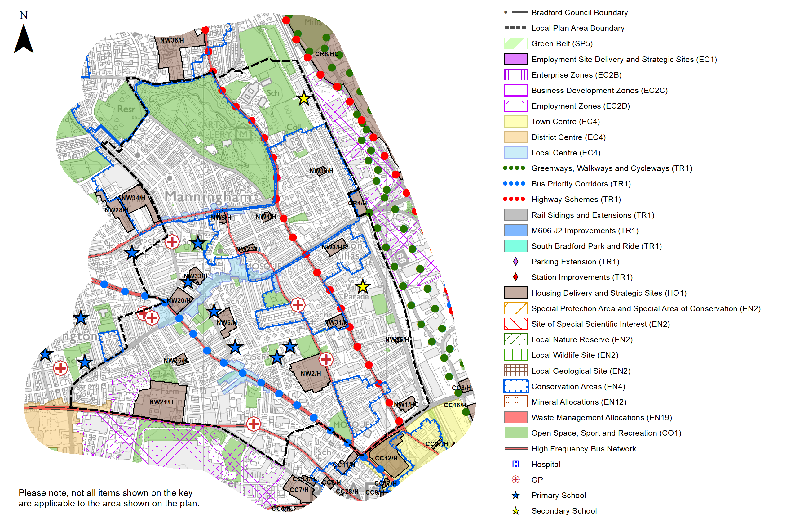
Bradford North West
Introduction
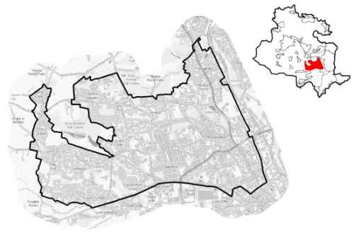
5.5.1 The Local Plan settlement hierarchy identifies Bradford North West as one of four quadrant areas defined within the wider Regional City of Bradford. The area has a strong urban grain which fans outwards from the city centre with and less dense development toward the fringes. The area has a strong but mixed character provided by the steeply sloping streets of former workers terraces in Girlington, the more rural nature of Sandy Lane, the former rural cores of Allerton and Heaton and the fine Victorian mansions of Heaton Grove. The area is broadly defined by Thornton Road to the south, Manningham Lane to the east and Heaton Woods to the north.
5.5.2 The North West area covers 1,145 hectares and is primarily residential in character with strong commuter and access connections to Bradford City Centre and locations further afield such as Halifax, Leeds and North Yorkshire.
5.5.3 Bradford North West includes the wards of Heaton, Manningham, Toller, Girlintgton, Allerton, the northern part of Clayton and Fairweather Green and a small part of Shipley ward.
Figure 1: Location Plan
5.5.4 The area is a densely developed and populated urban environment which has a has a total resident population of 76,666 people. Further characteristics of Bradford North West show:
- It has a higher percentage of residents (27.9%) who are aged 0-15 compared to both the England and West Yorkshire (sub regional) averages (19.2% and 20.6% respectively), whilst it has a below average population of those aged over 65.
- It has one of the highest percentages of people who consider themselves to be non-white British than other areas (74.3%) which is significantly higher than West Yorkshire as a whole (21.6%).
- Household composition is broadly similar to the sub regional picture, with the highest proportion being married households with the exception of pensioner and cohabiting households where proportions are much lower. Pensioner households fall below average accounting for 12.9% compared with the regional average of 19.5%.
Planning for Prosperity
5.5.5 The Local Plan settlement hierarchy under Policy SP3 identifies the Regional City as the key focus for housing, employment, shopping, leisure, education, health and cultural activities and facilities. Growth in the North West quadrant will transform the economic, environmental, physical and social conditions of local communities and support the long term regeneration of both the regional city and wider District.
5.5.6 Bradford North West is characterised by pockets of deprivation within all wards, most notably Manningham and Thornton and Allerton. In the rank of all 30 wards in the Bradford District, Manningham ranks as the most deprived. Biases include health, income, employment and education deprivation. 53,577 people living in Bradford North West live within the 20% most deprived areas of the country. This in nearly twice the west Yorkshire average. Figure 2 shows the overall picture of deprivation in the area.
Figure 2: Index of Multiple Deprivation – Bradford North West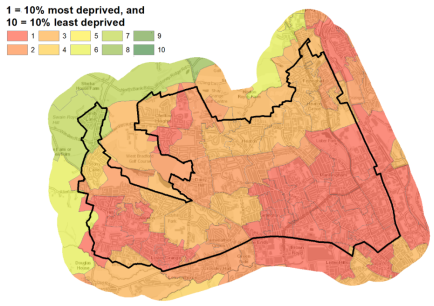
Economy and Employment
5.5.7 28,472 people are economically active in Bradford North West, this equates to 58.4% of the population, significantly below the West Yorkshire average of 68.5%, with 12.7% claiming unemployment benefit (regional average 7.3%). Annual average household incomes are £34,575 which is around £4,000 below the regional figure of £38,499. The largest employment sectors for local residents are retail, health and social work and education.
5.5.8 The main employment areas are located outside of the Bradford North West area to the south of Thornton Rd (Bradford South West) and east of the Airedale railway line (Canal Rd Corridor), but there are pockets of employment between Manningham Lane and the railway line and between City Road and Thornton Rd. The Bradford Hospital Trust is the major employer in the area with over 5,500 staff spread across a number of locations, which include the BRI and Lynfield Mount Hospitals which sit within the area.
5.5.9 Business Register and Employment Survey (BRES) data indicates that the three largest industry groups by workforce jobs (all people in employment) are health, education and manufacturing with 23% of the working population who reside in the area are in professional or associate occupations, slightly lower than the west Yorkshire average.
5.5.10 In relation to digital connectivity, average broadband speeds in Bradford North West are just under 50 megabytes per second which is above the West Yorkshire average, whilst there are 143 premises where speeds are below the Universal Service Obligation (USO)[1] which again is lower than the sub regional average.
5.5.11 Policy SP6 sets a District target for the provision of at least 72ha of open market employment land in the District with a significant proportion in the Regional City – use classes B2, B8 and E (formerly B1 type uses). Sites for new employment are identified on the Policies Map but there are no current proposals within the Bradford North West area.
Retail
5.5.12 All retail centres have been subject to a review as part of the Retail and Leisure Study (2019). The original study was completed in 2012. The City Centre is the main focus for retail and service provision for the District followed by the Principal Towns, District Centres and Local Centres.
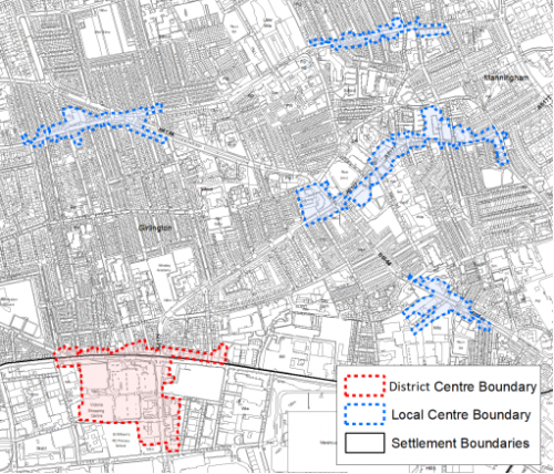
5.5.13 The Local Plan identifies Girlington District Centre (Figure 3a) as the main focus for convenience retail and limited comparison retail and a range of non-retail services such as banks, building societies, restaurants, cafes and other local public facilities. The majority of the District Centre lies to the south of Thornton Rd and largely falls in the Bradford South West sub area, but there are a number of small independent shops forming a more traditional linear form along the frontage of the north side of the road.
5.5.14 The study concluded that the centre is the highest ranking District centre in the Bradford District and still performs an important convenience shopping role (Morrison's and Lidl), despite a decrease in recent years, as a result of the opening of other convenience competition in surrounding areas, such as Asda (Cemetery Rd) and Aldi (Allerton Rd). The study also concluded that the vacancy rate was above the national average but that this had changed little since 2012. It concluded that the centre as a whole was performing well despite some neglect and the less attractive environment caused by being located at a busy junction.
5.5.15 The Local Plan also identifies seven designated Local Centres within Bradford North West including:
- Allerton
- Carlisle Rd/Whetley Hill
- Duckworth Lane
- Frizinghall
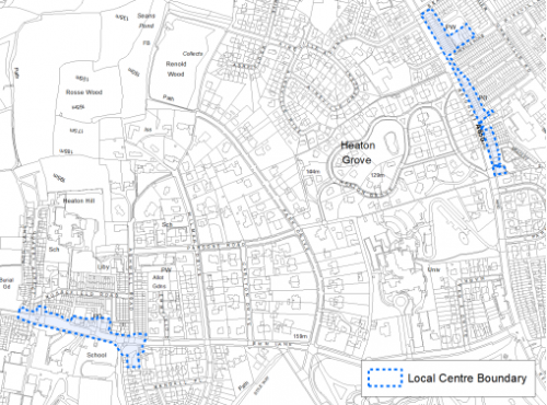
- Heaton
- Oak Lane, Manningham
- White Abbey Road
5.5.16 The boundaries for these areas are shown on the policies map and below at figures 3a to 3c below. These centres cater for general everyday shopping needs to minimise the need to travel.
5.5.17 The Carlisle Road/Whetley Hill Local contains commercial units on both sides of Carlisle Rd up to the junction with Church Street with a variety of facilities which have increased in number since the last study in 2012. It concluded that the centre offers a range of convenience and comparison shops and other services in an area with mixed environmental quality. A number of shops are in poor condition and cosmetic improvements would improve visual amenity of the area
5.5.18 In relation to Duckworth Lane, the study noted that it offers good provision of retail and service with falling vacancy rates. In conclusion the study found the centre to be healthy and viable but with issues relating to parking provision and a lack of planting and vegetation.
5.5.19 The Oak Lane Local Centre was noted as having a long standing vacant plot on the corner of Oak Lane and St Marys Rd which detracts from the environmental quality of the centre. This plot is identified for new housing development. Whilst convenience uses are higher than national averages, comparison, uses were generally low and despite a number of vacancies the area is considered to be healthy.
Figure 3a: Girlington District Centre and Carlisle Road/Whetley Hill, Duckworth Lane, Oak Lane and White Abbey Road Local Centres
5.5.20 The Retail and Leisure Study noted that the White Abbey Road Local Centre had a "relatively narrow comparison offer" that "appears oriented to cater to specific and specialist needs which could potentially attract people from a further catchment". The mix of retail uses is lower than the national average but the area was considered to be in good condition.
5.5.21 The Frizinghall Local Centre identified above, according to the study, had changed little since the last study in 2012 with the exception of some changes of unit and use. Vacancy rates in Frizinghall lie above the national average. In summary the study noted that the buildings were in good condition generally, but recommended cosmetic and environmental improvements "such as additional planting".
5.5.22 The Retail and Leisure Study considered Heaton to be "attractive, clean and well maintained" but with limited pedestrian footfall. The study concluded that the centre has a limited function in meeting local residents daily needs and recommended that additional safe crossing points be identified.
Figure 3b: Frizinghall and Heaton Local Centres
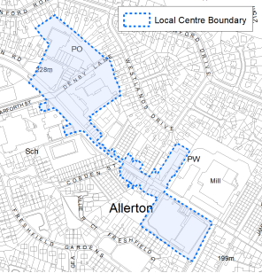
5.2.23 The Retail and Leisure Study commented that since the last study, a new Aldi supermarket had been built in Allerton but that the rest of the centre had a number of vacancies which detracted from the "environmental quality" and the centre was generally "tired with very limited soft landscaping". It recommended an extension to the Local Centre boundary to include Aldi.
Figure 3c: Allerton Local Centre
5.5.24 In summary the retail offer in the Local Centres in Bradford West offers variety but has some key challenges which include, the need to monitor vacancy rates and carry out improvements to the environmental quality.
Transport and Access
5.5.25 Lying in the central part of the District, Bradford North West benefits from good access into the City Centre via numerous bus and rail services which provide good links beyond the Bradford District. Thornton Road and Allerton Rd, Toller Lane and Manningham Lane are the main roads into and out of the city and all are frequent bus routes offering regular services throughout the day. Frizinghall station on the edge of the settlement area provides access into the city with connectivity further afield via the Bradford Interchange or northwards via Shipley through to connections with, Wharfedale, Leeds and Skipton. Leeds Bradford International Airport is 15 km away.
5.5.26 Key Transport issues include traffic congestion along the main routes out of the city centre, Queens Road junction with Manningham Lane is covered by an Air Quality Management Area (AQMA) and a large section, up to North Park Road and south of Carlisle Road are with the areas identified as areas of air quality concern (Clean Air Zones - CAZ). The £47m Bradford to Shipley Improvement scheme proposes a raft of measures to improve air quality, reduce accidents and make surrounding areas more ecologically friendly. The scheme is currently under development, but measures may include diverting non local traffic from Manningham Lane to Canal Road and improving junctions to improve the flow of traffic. Bus priority measures are also being worked up for the White Abbey Road, Toller Lane route.
5.5.27 35% of all households have no car compared with 29% across West Yorkshire. The value of public transport and good walkable local services is therefore of great importance.
5.5.28 Strategic transport infrastructure projects to be delivered within the plan period and protected routes are set out on the Policies Map with the local plan. Key initiatives within Bradford North West are detailed in Table 1 below.
Table 1: Bradford North West Transport Projects
|
Policies Map Ref. |
Project Name |
Local Area |
|
TR1.E.1 |
Bradford to Shipley route improvement scheme (Manningham Lane) |
Manningham and Heaton |
|
TR1.C.2 |
Bus Priority Corridor (White Abbey Road, Toller Lane to Heights Lane) |
Manningham, Girlington and Heaton |
Planning for Homes
5.5.29 Bradford North West has 23,693 dwellings, of which 60.9% are owner occupied, the remainder are rented from, housing associations and private landlords. The largest proportion (71.2%) of the area's housing stock consists of terraced housing and semi- detached properties which is slightly above the regional average, the number of detached homes, is lower than the regional average (16.4%) at 10.5%. Over half of the housing stock was built before 1939 and 34.7% between 1945 and 1999. Figure 4 below provides further information.
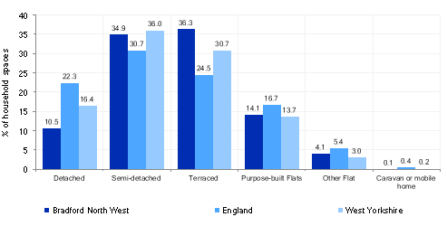
Figure 4: Bradford North West – Dwelling Type Breakdown
5.5.30 Average house prices across all house types is lower than the West Yorkshire average at £131,145 which is over £50,000 less than the regional average of £183,194. The total affordability ratio between house prices and annual earnings which is usually used as a proxy for number of years' worth of earnings required for a house deposit, is 2.61 years, compared to a West Yorkshire average of 2.96, meaning that the area is theoretically more accessible for first time buyers.
5.5.31 Delivering new housing is a key part of the overall development strategy for the District. The Local Plan seeks to support the creation of sustainable communities in Bradford North West through the regeneration of existing urban areas, particularly supporting the economic, environmental, physical and social transformation of key areas including; Manningham, Allerton and Girlington, through the re-cycling of brownfield land and; the expansion of the urban area in Allerton and Heaton. It will ensure that the housing needs and aspirations of local people can be met, together with those of future residents, for market and affordable housing. In addition, it will support the economic and regeneration aspirations for the wider area, as well as reflecting its role as part of the Regional City.
5.5.32 Policy SP8 sets out a requirement of 2,900 dwellings that will be delivered within Bradford North West within the plan period. These will be delivered through a mix of committed sites that are either under construction or have planning permission (but have not yet commenced), as well as new site allocations. These new homes will be delivered by a mix of sites including existing capacity within the urban area together with some contribution from the Green Belt in sustainable locations. Table 2 below sets out the housing position for Bradford North West which also includes the application of non- implementation or discount rates for planning permissions and allocations. The Council will be supportive of additional proposals for new homes on additional small sites, particularly those that provide a redevelopment opportunity to bring forward land which has been previously used. Support will also be provided to developers who wish to redevelop larger sites and/or buildings for new homes not currently identified, subject to all relevant policies in the Local Plan
Table 2: Bradford North West- Summary of Housing Requirement and Supply
|
Housing Target |
2,900 units |
|
Carried Forward Commitments |
899 |
|
Commitment Discounted by 10% |
809 |
|
Remaining Allocation Requirement |
2,091 |
|
Identified Allocations |
2,357 |
|
Allocations Discounted by 10% |
2,121 |
|
Total Supply Contribution from Allocations |
2,121 |
5.5.33 After the commitments are discounted the residual allocation requirement is 2,091. The evaluated total site supply of housing units form preferred site options equates to 2,357 units which once discounted for non-implementation leaves a final allocation contribution of 2,121 units, just above the remaining requirement.
5.5.34 Bradford North West's allocation mix of 36 sites includes, 16 sites which are brownfield (comprising previously used land and buildings, 6 are mixed (brownfield and greenfield), and 14 are predominantly greenfield. Six sites lie within the current Green Belt the rest are within the urban area. The identified sites have the potential to support a wide range of housing types to meet the housing requirement and are set out in Table A. These sites are also identified on the Policies Map and in the Site Pro-formas below. The development of site allocations should be in accordance with specified development guidelines and approximate site provision figures and all other relevant policies of this Local Plan. In delivering the target for new homes in Bradford North West it has been necessary to make some changes to the adopted green belt. Policy SP5 sets out The Councils approach and justification for green belt releases to accommodate new development and lists the sites proposed for allocation which current lie within or partly within the green belt
Planning for Places and Communities
Green Belt, Natural Landscape and Historic Character
5.5.35 Bradford North West is characterised by urban landscape divided by established parks and less formal urban greenspaces out to rural landscape which frames the area on the western and northern boundaries. Land to the west lies within the Bradford Green Belt and falls partly in the Thornton and Queensbury Landscape Character Area and partly. The prevailing landscape in this area is characterised by mixed upland pasture and has been assessed as being in strong but declining character, with high historic continuity which is sensitive to change.
5.5.36 Land to the north lies within the Wilsden Landscape Character Area. The prevailing landscape in this area is characterised by mixed upland and enclosed pasture which is moderate but declining with medium historic continuity. These areas should be further enhanced. The area also includes areas of wooded valley with strong historic continuity and where development will be resisted.
5.5.37 The Bradford North West area is historically important. Heaton and Manningham areas contain numerous Victorian villas, cottages and mill buildings built by the wealthy wool merchants of the 19th century and as a consequence there are a total of 559 Grade II and 9 Grade II* Listed Buildings and 7 Conservation Areas. The listed buildings are scattered across the sub area with the most significant clusters within the conservation areas.
5.5.38 Apsley Crescent, Manningham, is considered to be in a poor and deteriorating condition and there are buildings requiring attention in Heaton estates, North Park Road, Southfield Square and St Pauls, Manningham. Other notable buildings in the area include Manningham Mill (grade II* listed building) - parts of which require further repair, Bradford Grammar School, Whetley and Allerton Mills and the former Hall Marks card building on Bingley Rd. Lister Park within the North Park Road conservation area is also a historic park and garden.
Green Infrastructure (GI), Ecology, Open Space and Flood Risk
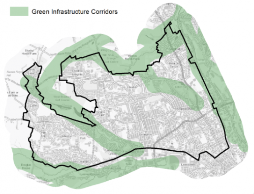
5.5.39 Bradford North West is characterised by an urban landscape of strong urban grain and steep wooded valleys. Key blue corridors include Chellow Dean reservoirs and Chellow Dean Beck woods, Pitty Beck, Allerton and Red Beck, Heaton. Key green corridors are Heaton Woods and Northcliffe Park, Chellow Dean and Lister Park. Green and blue infrastructure corridors provide opportunities for wildlife to move around, provide linked open spaces and the Plan will seek to enhance these. Figure 5 illustrates their location.
Figure 5: Green Infrastructure Corridors
5.5.40 There are number of biodiversity and ecological assets within or close proximity to Bradford North West settlement boundary, such as the Pitty Beck Valley, Stoney Ridge plantation and Chellow Dean valley and woods and Heaton Woods which are ancient woodlands.
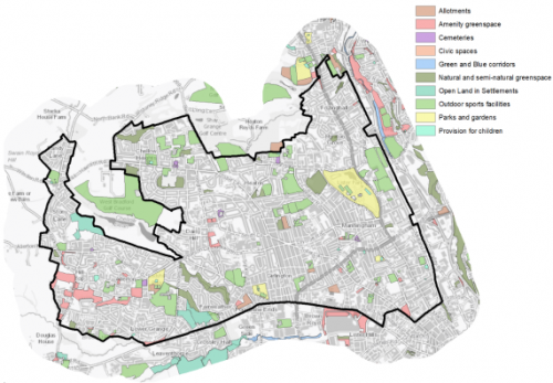
5.5.41 There are 158 sites identified as open space within Bradford North West covering an area of around 258.08ha. Aside of the assets identified above which are also important areas for recreation, other key areas are West Bradford Golf course, the open space network across Allerton including the Millennium Green, West Park, Girlington and playing fields at Scotchman Road, Heaton. Whilst there is a good range and spread of outdoor sport provision within the area, there is a notable deficiency in provision of natural greenspace and Parks in areas like Girlington where there is high density terraced housing with little room for more provision. Figure 6 provides an illustrative overview of the area's open spaces.
Figure 6: Bradford North West - Open Space Overview
5.5.42 There are no significant flood risk concerns in Bradford North West with the exception of a small area north and south of Bull Royd Lane where the Chellow Dean Beck passes through a culvert under the road. There are however small parts of the settlement where there is potential for surface water flooding to occur due to the topography and potential for surface water to periodically overwhelm road drains.
Community Infrastructure – Education, Health and Utilities
5.5.43 Bradford North West has a wide range of community facilities to meet the day to day needs of its local residents. These facilities range from schools, hospitals, GP surgeries through to post offices, places of worship, community halls/centres, playgrounds, a library and various sporting facilities.
5.5.44 The area is served by 23 primary schools and 5 state secondary schools. Access to additional provision is also available in neighbouring areas such as Beckfoot Thornton to the south of Thornton Road. Pupils attainment levels at Key Stage 4 (GCSE) is below the West Yorkshire and national (England) average scores at 328.2 compared to 353.5 and 366.3 respectively. This gap has fluctuated since 2003/2004 but is now narrowing.
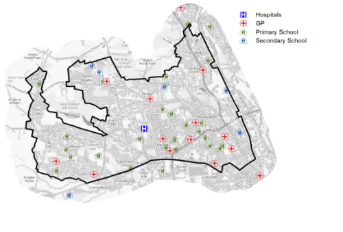
5.5.45 Bradford North West has a number of NHS registered healthcare facilities within the area. There are 14 GP surgeries/health centres, secondary, emergency and other hospital healthcare is provided at The Bradford Royal Infirmary (BRI) on Duckworth Lane and at St Luke's Hospital which lies in Bradford South West. The Lynfield Mount Hospital to the north west of BRI provides mental health provision. Figure 7 shows the location of local schools and medical facilities.
5.5.46 Average life expectancy at birth for Bradford North West residents is 76 for men and 80 for women, which is lies slightly below both the West Yorkshire and England averages. Healthy life expectancy is 55 for both men and women which is up to 10 years less than the England average.
Figure 7: Schools & Medical Facilities in Bradford North West
5.5.47 When planning for the long-term development of Bradford North West, it is vital that new development is supported by the appropriate infrastructure. The capacity, quality and accessibility of services and facilities are all key components in ensuring people can enjoy living, working and visiting the area. The council will continue work with key infrastructure providers and others including the Local Education Authority, Clinical Commissioning Group and utilities providers to determine the impacts of future growth and development on local infrastructure capacity and provision. Further infrastructure details will be published through the Local Infrastructure Plan and as part of the Regulation 19 stage of the local plan.
Local Area Strategies and Plans
Bradford North West Local Areas
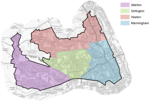
5.5.48 The Bradford North West sub-area has been broken down into 4 defined local areas with supporting spatial strategies; these are referred to as: Heaton, Manningham, Girlington and Allerton. These local areas are set out in Figure below. Each spatial strategy provides an overview of the local area and sets out the preferred allocations for housing and employment sites.
Figure 8: Bradford North West Local Plan Areas
|
Local Area Strategy and Plan - Allerton |
|
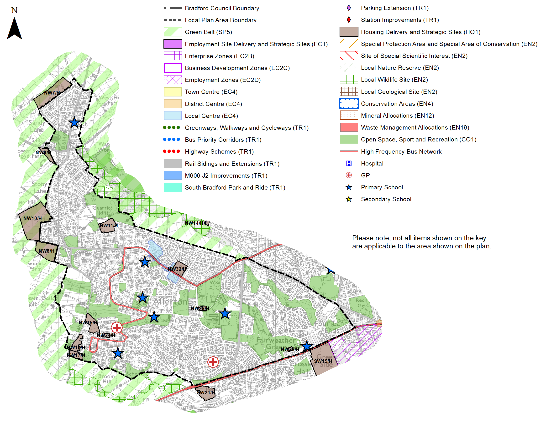
The key elements of the local area strategy for Allerton include:
|
|
Local Area Strategy and Plan - Girlington |
|
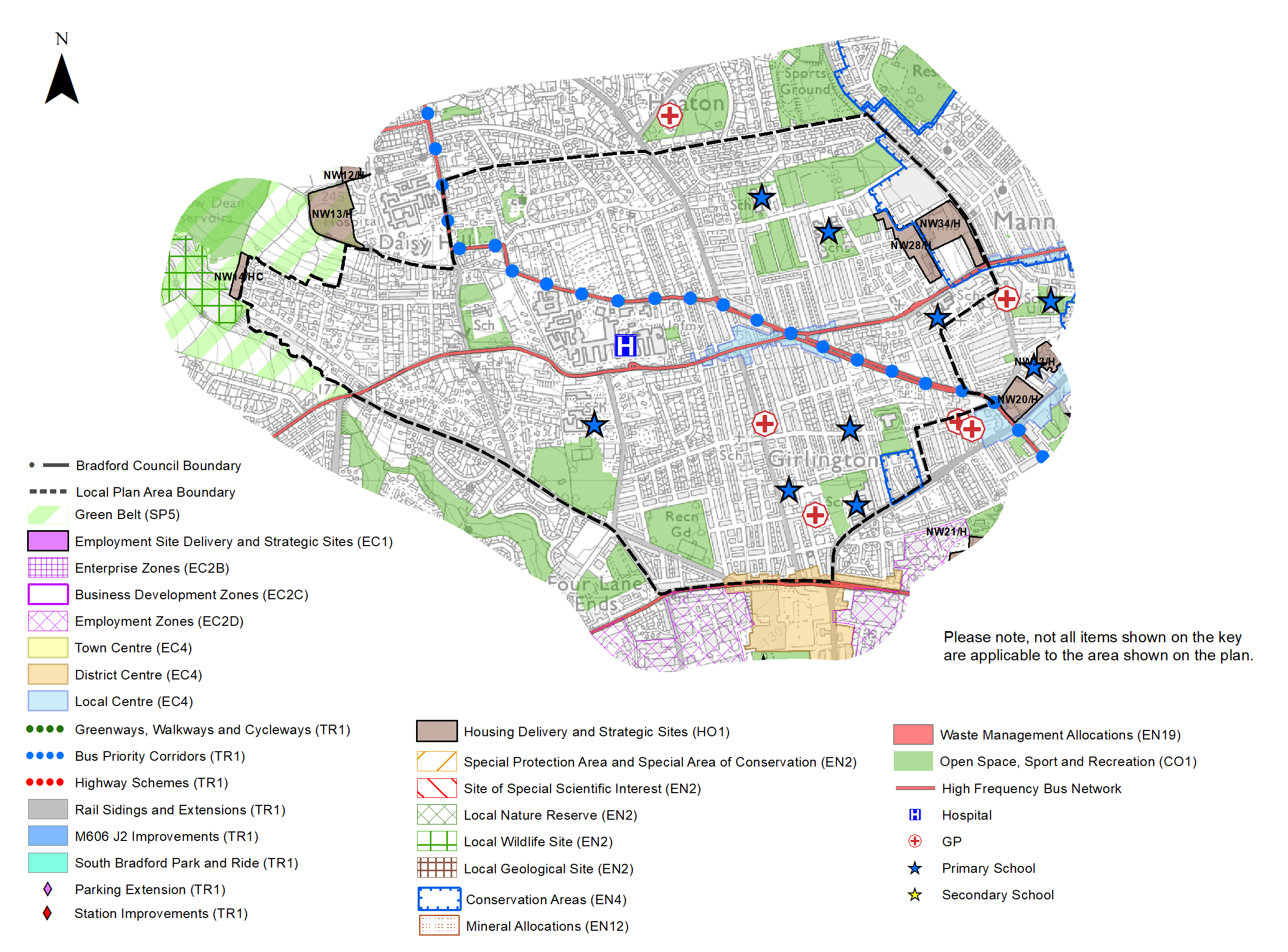
The key elements of the local area strategy for Girlington include:
|
|
Local Area Strategy and Plan - Heaton |
|
The key elements of the local area strategy for Heaton include:
|

|
Local Area Strategy and Plan - Manningham |
|
The key elements of the local area strategy for Manningham include:
|
(10) Consultation Question 89
Local Area Strategy and Plan - Allerton
Q. Please provide any comments you may have on the area strategy?
If you have an alternative to the approaches undertaken, please provide further details and evidence in support.
(1) Consultation Question 90
Local Area Strategy and Plan - Girlington
Q. Please provide any comments you may have on the area strategy?
If you have an alternative to the approaches undertaken, please provide further details and evidence in support.
(5) Consultation Question 91
Local Area Strategy and Plan - Heaton
Q. Please provide any comments you may have on the area strategy?
If you have an alternative to the approaches undertaken, please provide further details and evidence in support.
(2) Consultation Question 92
Local Area Strategy and Plan - Manningham
Q. Please provide any comments you may have on the area strategy?
If you have an alternative to the approaches undertaken, please provide further details and evidence in support.
Preferred Site Allocations and Site Pro-formas
5.5.49 There are no preferred site allocations for employment in Bradford North West. The preferred housing site allocations are detailed below. This table is subsequently followed by site pro forma for each site which provides a summary of key site information and characteristics.
Table A: Bradford North West Housing Sites - Preferred Allocations
|
Site Ref |
Site Name |
Dwellings |
Local Area |
|
NW1/HC |
Snowden Street |
229 |
Manningham |
|
NW2/H |
Drummond Trading estate, Lumb Lane |
129 |
Manningham |
|
NW3/HC |
Spring Bank Place |
14 |
Manningham |
|
NW4/H |
Mansfield Road |
16 |
Manningham |
|
NW5/H |
St Marys Road |
10 |
Manningham |
|
NW6/H |
Priestman Street |
60 |
Manningham |
|
NW7/H |
Acacia Drive, Sandy Lane |
100 |
Allerton |
|
NW8/H |
High Ash Farm, Allerton Road, Allerton |
68 |
Allerton |
|
NW9/H |
Wilsden Road/West Avenue, Sandy Lane |
22 |
Allerton |
|
NW10/H |
Allerton Road, Prune Park Lane |
160 |
Allerton |
|
NW11/H |
North Parade, Allerton |
45 |
Allerton |
|
NW12/H |
Lynfield Drive, Daisy Hill |
12 |
Heaton |
|
NW13/H |
Millmoor Close |
58 |
Heaton |
|
NW14/HC |
Chellow Lane |
6 |
Girlington |
|
NW15/H |
Merrivale Rd, Allerton |
54 |
Allerton |
|
NW16/H |
Allerton Lane/Chevet Mount (1) |
28 |
Allerton |
|
NW17/H |
Allerton Lane/Chevet Mount (2) |
24 |
Allerton |
|
NW18/H |
Haworth Road Playing Fields, Heaton |
80 |
Heaton |
|
NW19/H |
Bingley Road, Long Lane, Heaton |
300 |
Heaton |
|
NW20/H |
Former Reservoir, Carlisle Road |
43 |
Manningham |
|
NW21/H |
Whetley Mills |
250 |
Manningham |
|
NW22/H |
Alton Grove, Frizinghall |
5 |
Heaton |
|
NW23/H |
Church Street, Manningham |
10 |
Manningham |
|
NW24/H |
Rayner Mount, Allerton |
6 |
Allerton |
|
NW25/H |
Former night club and Stone yard, Belvedere Terrace |
15 |
Manningham |
|
NW26/H |
Former storage yard, Thornton Road- Fairweather Green |
5 |
Allerton |
|
NW27/H |
Frizinghall Road |
6 |
Heaton |
|
NW28/H |
Patent Street, Manningham |
75 |
Girlington |
|
NW29/H |
Chapel Lane, Allerton |
5 |
Allerton |
|
NW30/H |
7-9 Oak Avenue |
12 |
Manningham |
|
NW31/H |
Former Manningham Middle School, Manningham Lane |
30 |
Manningham |
|
NW32/H |
Allerton Mills |
200 |
Allerton |
|
NW33/H |
Site of Anvil Court, Church Street, Manningham |
30 |
Manningham |
|
NW34/H |
Lister Mill and surrounds |
50 |
Girlington |
|
NW35/H |
Springfield Place |
5 |
Manningham |
|
NW36/H |
Heaton Mount |
195 |
Heaton |
|
Total |
2,357 |
Note: The sites labelled "HC" had outline planning permission at 31st March 2020. Other permissions have been granted on sites since 1st April 2020
(11) Consultation Question 93
Bradford North West Site Allocations and Site Pro Formas
The Local Plan sets out a series of preferred site allocations. If you wish to make representations on any of the sites proposed, please provide site reference and feedback under this question.
If you wish to propose an additional or alternative site(s) to the preferred allocations listed, please also provide a plan with a red line and any further details in support.
[1] Universal Service Obligation (USO) - download speeds at or above 10Mbit/s and upload speeds at or above 1Mbit/s including non-matched records and zero predicted speeds
(1) NW1/HC - Snowden Street
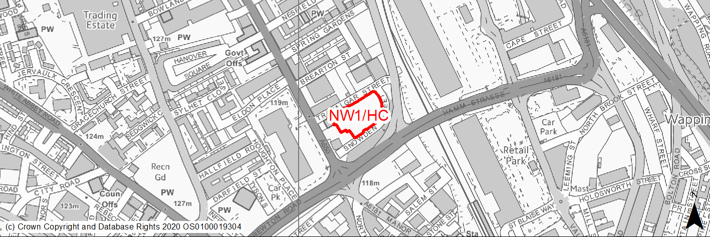
Site location
Regional City - Bradford NW
Ward
City
Site description
Cleared site formerly commercial use. Outline permission for mixed use to include community use and apartments
Proposed Allocation
Housing
SHLAA referencce
NW/001
Indicative no. dwellings
229
Site area (Gross) (ha)
0.49
Ownership
Private
Delivery timescales
Developable (6-10 years)
Type (PDL/Greenfield)
PDL
Green Belt
No
Flood Zone
Flood Zone 1
Potential site access
Access would be from Snowden Street for the residential element of the scheme.
Public Transport Accessibility
Site within 400m of a High Frequency Bus Network
Sustainability Appraisal
See individual Sustainability Appraisal site comment in the accompanying report.
Habitats Regulations Assessment
This site is beyond the zones of influence of the South Pennine Moors SPA/SAC and is therefore unlikely to have any significant effects, a HRA is not required.
Green Belt
N/A – Site not within the Green Belt.
Constraints and Opportunities
• An opportunity to re-use and regenerate an edge of city centre brownfield site providing new homes in a highly sustainable location.
• Cleared site formerly commercial use.
• The site lies within draft Clean Air Zone and adjoins Manningham Lane and Hamm Strasse which are identified as having high NO2 levels.
• Sites lies just to the north (Eldon Place) and the south (City Centre) of 2 conservation areas.
Development considerations
• Development will need to consider how to mitigate any air quality issues.
• A high quality development is required for this key edge of city centre site.
• Development design and layout should reflect its location close to neighbouring conservation areas and protect their setting.
Conclusion/Summary
A previously developed site in a sustainable location within Pool 1 (lowest flood risk and within the urban area) and thus suitable for residential development. The site has outline planning permission.
(2) NW2/H - Drummond Trading Estate, Lumb Lane
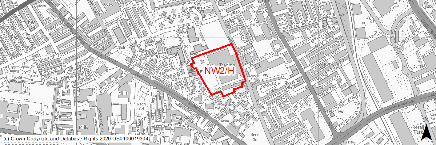
Site location
Regional City - Bradford NW
Ward
Manningham
Site description
Former mill site now mostly cleared following major fire. Some listed structures remain.
Proposed Allocation
Housing
SHLAA referencce
NW/002
Indicative no. dwellings
129
Site area (Gross) (ha)
3.03
Ownership
Private
Delivery timescales
Deliverable (0-5 years)
Developable (6-10 years)
Type (PDL/Greenfield)
PDL
Green Belt
No
Flood Zone
Flood Zone 1
Potential site access
Access could be achieved from Lumb Lane.
Public Transport Accessibility
Site within 400m of a High Frequency Bus Network
Sustainability Appraisal
See individual Sustainability Appraisal site comment in the accompanying report.
Habitats Regulations Assessment
This site is beyond the zones of influence of the South Pennine Moors SPA/SAC and is therefore unlikely to have any significant effects, a HRA is not required.
Green Belt
N/A – Site not within the Green Belt.
Constraints and Opportunities
• A major regeneration opportunity for the redevelopment of a derelict brownfield site close to the city centre.
• Some listed structures remain despite site clearance following fire. The site also lies within the 50M buffer zone of listed buildings to the no the site and St Mary Magdalene Church.
• Site lies within a draft Clean Air Zone.
• Several small areas within the site are identified as being subject to risk of surface water flooding - the draft SFRA does not consider the risk significant.
Development considerations
• Design and layout should ensure that any impacts on the listed buildings within and adjoining the site are avoided / mitigated.
• Development will need to consider how to mitigate any air quality or surface water flood risk issues.
Conclusion/Summary
An important regeneration opportunity, a sustainable location within Pool 1 (lowest flood risk and within the urban area) where development could improve the area and conserve important listed structures.
(1) NW3/HC - Spring Bank Place
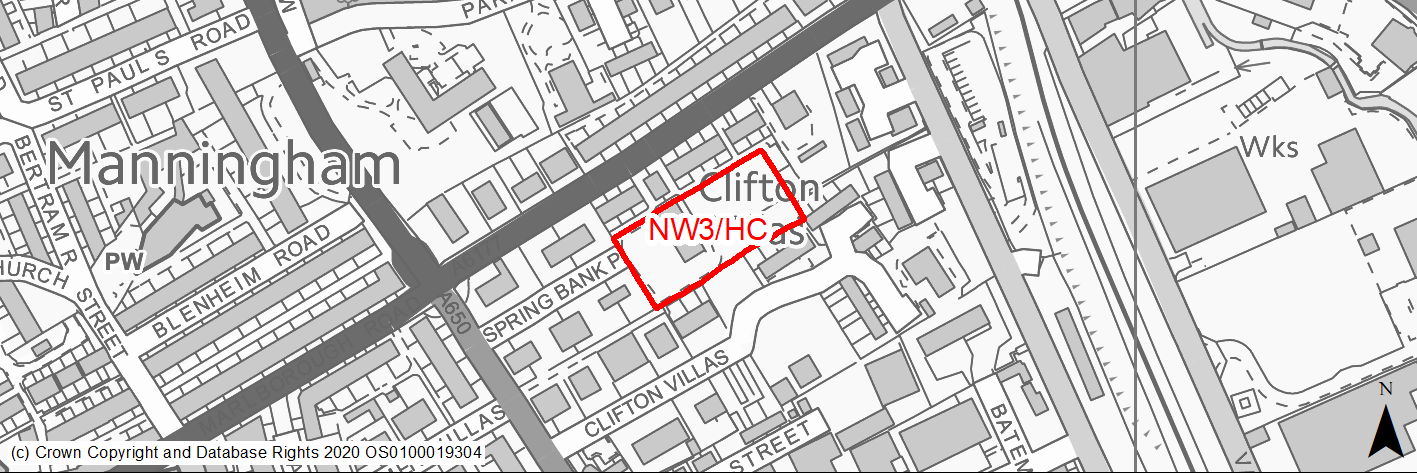
Site location
Regional City - Bradford NW
Ward
Manningham
Site description
Victorian Villa set in generous and under used grounds. Outline permission for demolition and change of use (2 units) and new build for 12 units.
Proposed Allocation
Housing
SHLAA referencce
NW/007
Indicative no. dwellings
14
Site area (Gross) (ha)
0.57
Ownership
Private
Delivery timescales
Deliverable (0-5 years)
Type (PDL/Greenfield)
Mixed
Green Belt
No
Flood Zone
Flood Zone 1
Potential site access
Access would be from Spring Bank Place.
Public Transport Accessibility
Site within 400m of a High Frequency Bus Network
Sustainability Appraisal
The site could deliver major positive effects for residents on both the health and education SA Objectives as a result of being within the target distances for all necessary health facilities and centres for primary and secondary education. A major adverse effect has been predicted for the air quality SA Objective as a result of the site being situated entirely within the CAZ and adjacent to an AQMA. This could potentially make achieving air quality improvement targets more difficult.
Minor positive effects were predicted for nearly all other socio-economic themed SA Objectives due to the benefits of new residential development for the local economy as well as the location of the site in relation to transport links, local services and amenities, and employment areas.
Minor adverse effects were predicted for a range of natural environment themed SA Objectives, primarily as a result of the impacts of new development on a majority greenfield site containing GI elements including trees. The site is within the Apsley Conservation Area, and new development here could have an adverse effect on the setting of this sensitive historic area.
Habitats Regulations Assessment
This site is beyond the zones of influence of the South Pennine Moors SPA/SAC and is therefore unlikely to have any significant effects, a HRA is not required.
Green Belt
N/A – Site not within the Green Belt.
Constraints and Opportunities
• Opportunity to provide new homes in a sustainable location.
• Site lies within draft Clean Air Zone and adjoins Manningham Lane and Queen's Road which are identified as having high NO2 levels.
• Site falls in Apsley Crescent conservation area & close to several Listed buildings.
• Site lies within the 150M and 250M buffer zone of and area of former landfill to the east.
Development considerations
• Design and layout should ensure that any impacts on the Conservation Area and listed buildings are avoided / mitigated.
• Development will need to consider how to mitigate any air quality issues.
• Design should where possible incorporate the retention of any mature trees.
• Surveys required to investigate and mitigate for any issues relating to former landfill activities.
Conclusion/Summary
The site lies in a sustainable location within Pool 1 (lowest flood risk and within the urban area) and, subject to a sensitive design is suitable for residential development. The site has outline planning permission.
(2) NW4/H - Mansfield Road
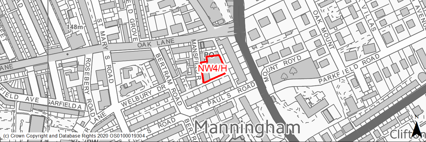
Site location
Regional City - Bradford NW
Ward
Manningham
Site description
Derelict and tipped land and vacant building on corner.
Proposed Allocation
Housing
SHLAA referencce
NW/010
Indicative no. dwellings
16
Site area (Gross) (ha)
0.21
Ownership
Private
Delivery timescales
Developable (6-10 years)
Type (PDL/Greenfield)
Mixed
Green Belt
No
Flood Zone
Flood Zone 1
Potential site access
Site access is available from Mansfield Road.
Public Transport Accessibility
Site within 400m of a High Frequency Bus Network
Sustainability Appraisal
A significant adverse effect has been predicted for the air quality SA Objective as a result of the site being within the CAZ. The site is also 200m north of an AQMA. No other significant effects predicted. The site would be a good opportunity to deliver biodiversity net gains, improvements to the local character, as well as further preservation/enhancements to the St Paul’s Conservation Area it falls within. The site is well located to provide residents here with good access to key services and amenities, buses, jobs, shops, and cultural spaces, with particularly good access to schools and health facilities.
Habitats Regulations Assessment
This site is beyond the zones of influence of the South Pennine Moors SPA/SAC and is therefore unlikely to have any significant effects, a HRA is not required.
Green Belt
N/A – Site not within the Green Belt.
Constraints and Opportunities
• Site falls in St Pauls Conservation Area - the site's sensitive development could contribute to improvement of one of the district's priority regeneration areas.
• A sustainable location with good accessibility to services and public transport.
• Site lies within draft Clean Air Zone.
• Parts of the site are covered by areas identified as having 1/100 or 1/30 year risk of surface water flooding.
• Priority Species - bat alert layer covers the site.
Development considerations
• Development will need to consider how to mitigate any air quality and surface water flood risk issues.
• Design and layout should ensure that any impacts on the Conservation Area and listed buildings are avoided / mitigated.
Conclusion/Summary
A previously developed site in a sustainable location within Pool 1 (lowest flood risk and within the urban area) where development could improve and regenerate the area. Suitable for residential development.
(2) NW5/H - St Marys Road
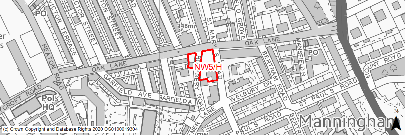
Site location
Regional City - Bradford NW
Ward
Manningham
Site description
Vacant land within St Pauls and North Park Road Conservation Area.
Proposed Allocation
Housing
SHLAA referencce
NW/012B
Indicative no. dwellings
10
Site area (Gross) (ha)
0.22
Ownership
Private/Council
Delivery timescales
Developable (6-10 years)
Type (PDL/Greenfield)
Mixed - Majority PDL
Green Belt
No
Flood Zone
Flood Zone 1
Potential site access
Site access is available from St Mary's Road.
Public Transport Accessibility
Site within 400m of a High Frequency Bus Network
Sustainability Appraisal
A significant adverse effect has been predicted for the air quality SA Objective due to the site being within the CAZ. An AQMA is also 350m south-east of the site. No other significant adverse effects predicted for the site. Development here would likely be an opportunity to deliver biodiversity net gains, improvements to the local townscape character, and improvements to the setting of St Paul’s Conservation Area as well as three Grade II Listed Buildings in proximity to the site. The site is well located to provide residents with good access to key services and amenities, jobs, shops, and cultural spaces, with particularly good access to schools and health facilities.
Habitats Regulations Assessment
This site is beyond the zones of influence of the South Pennine Moors SPA/SAC and is therefore unlikely to have any significant effects, a HRA is not required.
Green Belt
N/A – Site not within the Green Belt.
Constraints and Opportunities
• A brownfield site whose development would contribute to improvement and regeneration of the area.
• Site falls in St Pauls and North Park Road conservation area, but development of the site could make a positive impact on the area. Adjoins several listed buildings.
• Part of site lies within draft Clean Air Zone.
• Two single TPO at extreme SW boundary of site.
• There are some areas of the site which are identified as being subject to surface water flood risk, however draft SFRA does not consider risk to be significant.
Development considerations
• Design and layout should ensure that any impacts on the Conservation Area and listed buildings are avoided / mitigated.
• Development will need to consider how to mitigate any air quality and surface water flood risk issues.
• Development should where possible seek to retain protected trees.
Conclusion/Summary
The site lies in a sustainable location within Pool 1 (lowest flood risk and within the urban area) and subject to a sensitive design suitable for residential development.
(1) NW6/H - Derelict mill and single storey industrial buildings, Priestman Street
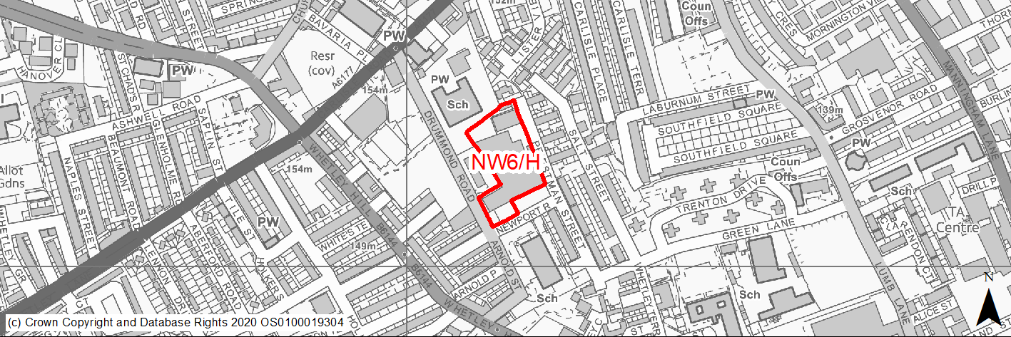
Site location
Regional City - Bradford NW
Ward
Manningham
Site description
Derelict mill and single storey industrial buildings in partial use for motor repairs.
Proposed Allocation
Housing
SHLAA referencce
NW/013A
Indicative no. dwellings
60
Site area (Gross) (ha)
0.89
Ownership
Private
Delivery timescales
Developable (6-10 years)
Type (PDL/Greenfield)
PDL
Green Belt
No
Flood Zone
Flood Zone 1
Potential site access
Access is available from Priestman Street and Newport Road.
Public Transport Accessibility
Site within 400m of a High Frequency Bus Network
Sustainability Appraisal
A significant adverse effect has been predicted for the air quality SA Objective due to the site being within the CAZ. No other significant effects predicted. The site would be a good opportunity to deliver biodiversity net gains and improvements to the local townscape character. The site is well located to provide residents with good access to key services and amenities, jobs, shops, and cultural spaces, with particularly good access to schools and health facilities.
Habitats Regulations Assessment
This site is beyond the zones of influence of the South Pennine Moors SPA/SAC and is therefore unlikely to have any significant effects, a HRA is not required.
Green Belt
N/A – Site not within the Green Belt.
Constraints and Opportunities
• A brownfield site whose development would contribute to improvement and regeneration of the area.
• Site lies within draft Clean Air Zone.
• There are some areas of the site which are identified as being subject to surface water flood risk, however draft SFRA does not consider risk to be significant.
Development considerations
• Development will need to consider how to mitigate any air quality and surface water flood risk issues.
Conclusion/Summary
A previously developed site in a sustainable location within Pool 1 (lowest flood risk and within the urban area) where development could improve and regenerate the area. Suitable for residential development.
(18) NW7/H - Acacia Drive, Sandy Lane
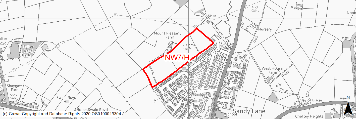
Site location
Regional City - Bradford NW
Ward
Thornton and Allerton
Site description
Level to slightly sloping fields within the green belt separated by stone walls and hedges.
Proposed Allocation
Housing
SHLAA referencce
NW/015
Indicative no. dwellings
100
Site area (Gross) (ha)
3.72
Ownership
Private
Delivery timescales
Developable (6-10 years)
Type (PDL/Greenfield)
Greenfield
Green Belt
Yes
Flood Zone
Flood Zone 1
Potential site access
Site could be accessed from end of Acacia Drive, but there are traffic problems on Cottingley Moor Road in the vicinity of the school and a robust Transport Assessment would be required to support any development proposal.
Public Transport Accessibility
The site is not located near to frequent bus or rail services.
Sustainability Appraisal
See individual Sustainability Appraisal site comment in the accompanying report.
Habitats Regulations Assessment
This site falls within 7km of the South Pennine Moors SPA/SAC a HRA must be undertaken to ensure there are no significant effects on these protected sites in terms of recreational pressures. Developments within these zones must comply with Policy SP11; an SPD is being produced to provide further guidance.
Green Belt
See individual Green Belt site assessment in the accompanying report.
Constraints and Opportunities
• Site lies within the green belt.
• There are records of priority species of open farmland including brown hare and ground nesting birds (lapwing, skylark etc) - these are declining species and the habitat should be conserved. Also bat alert layer covers the northern 1/3 of the site.
• Northern 1/5 of site lies within former coal mining High Risk Area
• N half of site lies within 200M buffer zone of overhead power line.
• Far NE corner of site lies within 250M buffer of a former landfill area.
• Not within the S Pennine Moors SPA / SAC however within Zone C (within 7KM) which requires consideration of potential impacts relating to recreation pressures.
• Site could be accessed from end of Acacia Drive, but need to assess impacts of this and other sites on the wider road network and on existing traffic problems and the scope for impacts to mitigated.
Development considerations
• Scheme design should aim through the use of new planting, soft landscaping and buffer zones to minimise landscape impact.
• Planting along the northern boundary will be required to create a buffer area around the existing farmstead and also provide a new strong edge to the built up area.
• Scheme will need to assess and mitigate impacts on wildlife and incorporate on or off site contributions to support protected species.
• Surveys required to investigate and mitigate for any issues relating to former landfill activities.
• Development will need to consider how to mitigate any surface water flood risk issues.
Conclusion/Summary
Although a green belt site, it lies in a sustainable location and subject to sensitive design is considered suitable for residential development.
(9) NW8/H - High Ash Farm, Allerton Road, Allerton
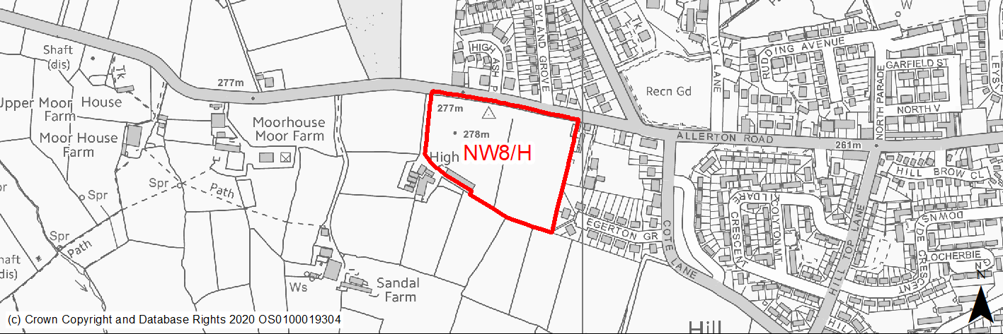
Site location
Regional City - Bradford NW
Ward
Thornton and Allerton
Site description
Level to slightly sloping fields within the green belt on edge of built up area.
Proposed Allocation
Housing
SHLAA referencce
NW/018
Indicative no. dwellings
68
Site area (Gross) (ha)
2.58
Ownership
Private
Delivery timescales
Developable (6-10 years)
Type (PDL/Greenfield)
Greenfield
Green Belt
Yes
Flood Zone
Flood Zone 1
Potential site access
Site can be accessed directly from Allerton Road or by improving the existing farm track
Public Transport Accessibility
The site is not located near to frequent bus or rail services.
Sustainability Appraisal
See individual Sustainability Appraisal site comment in the accompanying report.
Habitats Regulations Assessment
This site falls within 7km of the South Pennine Moors SPA/SAC a HRA must be undertaken to ensure there are no significant effects on these protected sites in terms of recreational pressures. Developments within these zones must comply with Policy SP11; an SPD is being produced to provide further guidance.
Green Belt
See individual Green Belt site assessment in the accompanying report.
Constraints and Opportunities
• The site lies within the green belt.
• It is visible in longer distance views but impacts are lessened by the existing settlement on the skyline.
• Site is located in High Risk Area for former coal mining activity.
• Not within the S Pennine Moors SPA / SAC however within Zone C (within 7KM) which requires consideration of potential impacts relating to recreation.
• Tiny area on eastern site boundary identified as being subject to 1/1000 year risk of flooding however the draft SFRA indicates no significant risk.
Development considerations
• Scheme design should aim through the use of new planting, soft landscaping and buffer zones to minimise landscape impact.
• Planting along the southern boundary will be required to provide a new strong edge to the built up area.
• Surveys required to investigate and mitigate for any issues relating to former coal mining activities.
• Development will need to consider how to mitigate any surface water flood risk issues.
Conclusion/Summary
Although situated within the green belt, the site lies in a sustainable location and could be developed in a way which minimises landscape and green belt impact and is therefore suitable for residential development.
(12) NW9/H - Wilsden Road/West Avenue, Sandy Lane
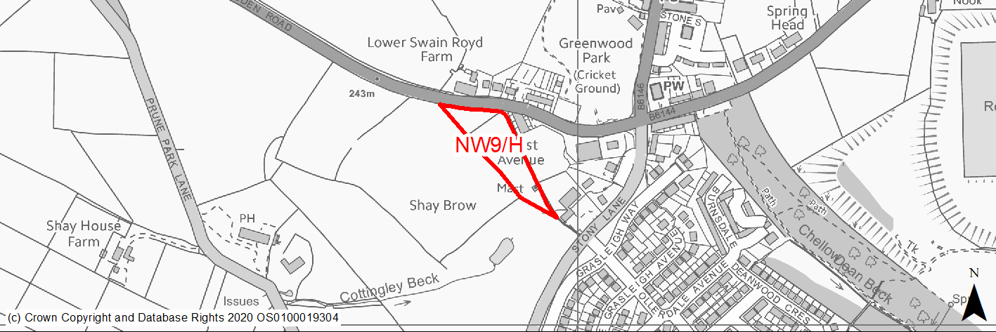
Site location
Regional City - Bradford NW
Ward
Thornton and Allerton
Site description
Level to sloping field on edge of the built up area.
Proposed Allocation
Housing
SHLAA referencce
NW/023
Indicative no. dwellings
22
Site area (Gross) (ha)
0.71
Ownership
Private
Delivery timescales
Developable (6-10 years)
Type (PDL/Greenfield)
Greenfield
Green Belt
Yes
Flood Zone
Flood Zone 1
Potential site access
Site can be accessed from Wilsden Road but any development will require comprehensive assessment and mitigation of problems on the local highway network.
Public Transport Accessibility
The site is not located near to frequent bus or rail services.
Sustainability Appraisal
See individual Sustainability Appraisal site comment in the accompanying report.
Habitats Regulations Assessment
This site falls within 7km of the South Pennine Moors SPA/SAC a HRA must be undertaken to ensure there are no significant effects on these protected sites in terms of recreational pressures. Developments within these zones must comply with Policy SP11; an SPD is being produced to provide further guidance.
Green Belt
See individual Green Belt site assessment in the accompanying report.
Constraints and Opportunities
• The site lies within the green belt.
• Within 50m buffer of Lower Swain Road Farm Grade II Listed Building.
• Within the buffer zone of landfill site just to the south.
• Site can be accessed from Wilsden Road but any development will require comprehensive assessment and mitigation of problems on the local highway network.
Development considerations
• Design and layout should ensure that any impacts on the listed buildings are avoided / mitigated.
• Surveys required to investigate and mitigate for any issues relating to former landfill activities.
Conclusion/Summary
A small site which although within the green belt could be developed in a way which minimises landscape and green belt impact and is therefore suitable for residential development.
(19) NW10/H - Allerton Road, Prune Park Lane
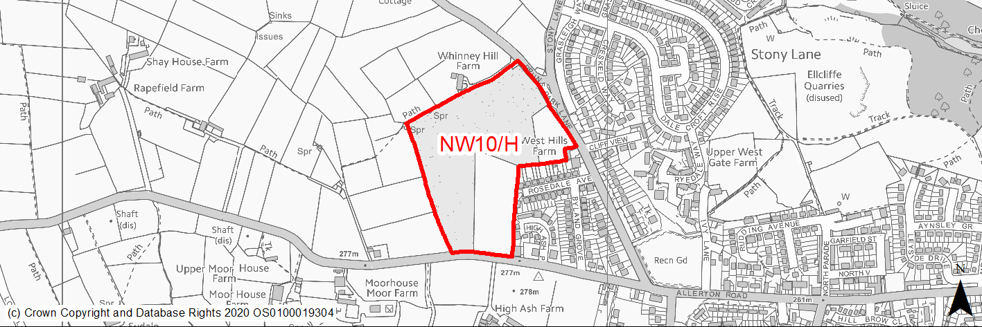
Site location
Regional City - Bradford NW
Ward
Thornton and Allerton
Site description
A number of separate fields within the green belt on the edge of Allerton / Sandy Lane, divided by dry stone walls.
Proposed Allocation
Housing
SHLAA referencce
NW/024 (part of)
Indicative no. dwellings
160
Site area (Gross) (ha)
6.17
Ownership
Private
Delivery timescales
Developable (6-10 years)
Type (PDL/Greenfield)
Greenfield
Green Belt
Yes
Flood Zone
Flood Zone 1
Potential site access
Site can be accessed off Prune Park Lane / Stony Lane and Allerton Road
Public Transport Accessibility
The site is not located near to frequent bus or rail services.
Sustainability Appraisal
See individual Sustainability Appraisal site comment in the accompanying report.
Habitats Regulations Assessment
This site falls within 7km of the South Pennine Moors SPA/SAC a HRA must be undertaken to ensure there are no significant effects on these protected sites in terms of recreational pressures. Developments within these zones must comply with Policy SP11; an SPD is being produced to provide further guidance.
Green Belt
See individual Green Belt site assessment in the accompanying report.
Constraints and Opportunities
• The site lies within the green belt and adjoins the built up area of Allerton.
• Grade II listed buildings Upper Swain Royd Farm lie to the SW.
• There are a couple of small areas subject to surface water flooding along the northern edges of the site.
Development considerations
• Scheme design should aim through the use of new planting, soft landscaping and buffer zones to minimise landscape impact.
• Planting along the western and northern boundaries will be required to provide a new strong edge to the built up area.
• Scheme will need to assess and mitigate impacts on wildlife and incorporate on or off site contributions to support protected species.
• Surveys required to investigate and mitigate for any issues relating to former landfill activities.
• Development will need to consider how to mitigate any surface water flood risk issues.
Conclusion/Summary
Although situated within the green belt, the site could be developed in a way which minimises landscape and green belt impact and is therefore suitable for residential development.
(2) NW11/H - North Parade, Allerton
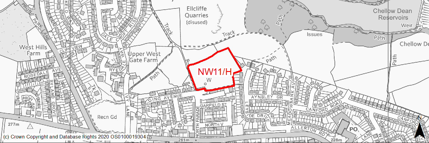
Site location
Regional City - Bradford NW
Ward
Thornton and Allerton
Site description
Rectangular site with access from North Parade. Part of RUDP phase 2 housing allocation.
Proposed Allocation
Housing
SHLAA referencce
NW/026B
Indicative no. dwellings
45
Site area (Gross) (ha)
1.42
Ownership
Council
Delivery timescales
Developable (6-10 years)
Type (PDL/Greenfield)
Greenfield
Green Belt
No
Flood Zone
Flood Zone 1
Potential site access
Site can be accessed through adjacent approved site. An access from North Parade might also be possible but would need further detailed investigation.
Public Transport Accessibility
Site within 400m of a High Frequency Bus Network
Sustainability Appraisal
Development at this site would be unlikely to result in a significant effect, either positive or negative, on any SA Objective. Minor positive effects were predicted for nearly all socio-economic themed SA Objectives due to the benefits of new residential development for the local economy as well as the location of the site in relation to transport links, local services and amenities, education facilities and employment areas. Minor adverse effects have been predicted for a range of natural environment themed SA Objectives, primarily as a result of the impacts of new development on a 100% greenfield site.
Habitats Regulations Assessment
This site falls within 7km of the South Pennine Moors SPA/SAC a HRA must be undertaken to ensure there are no significant effects on these protected sites in terms of recreational pressures. Developments within these zones must comply with Policy SP11; an SPD is being produced to provide further guidance.
Green Belt
N/A – Site not within the Green Belt.
Constraints and Opportunities
• An opportunity to deliver housing in a sustainable location on a site allocated for housing in the RUDP.
• Site lies in proximity to Chellow Dene which is of important ecological and recreational value.
• Priority Species - all but the western edge of the site lies within the bat alert area.
• Within 150 buffer zone of former landfill area to the N and former sandstone quarry.
• Majority of site lies within Low Risk Area for former coal mining activity. Tiny slither of land at southern boundary lies within the high risk area.
• Not within the S Pennine Moors SPA / SAC however within Zone C (within 7KM) which requires consideration of potential impacts relating to recreation pressures.
• A small area within site identified as subject to surface water flood risk but no issues raised in draft SFRA.
Development considerations
• Surveys required to investigate and mitigate for any issues relating to former coal mining and landfill activities.
• Development scheme should include planting and landscaping and be designed so as to compliment and enhance the recreational and ecological value of adjoining land.
• Development will need to consider how to mitigate any surface water flood risk issues.
Conclusion/Summary
Although a greenfield site, it lies in a sustainable location within Pool 1 (lowest flood risk and within the urban area) and is considered suitable for residential development.
(1) NW12/H - Lynfield Drive, Daisy Hill
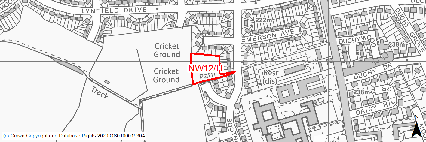
Site location
Regional City - Bradford NW
Ward
Heaton
Site description
Unused land with access.
Proposed Allocation
Housing
SHLAA referencce
NW/030C
Indicative no. dwellings
12
Site area (Gross) (ha)
0.33
Ownership
Council
Delivery timescales
Developable (6-10 years)
Type (PDL/Greenfield)
Greenfield
Green Belt
No
Flood Zone
Flood Zone 1
Potential site access
Site could be accessed from Millmoor Close.
Public Transport Accessibility
Site within 400m of a High Frequency Bus Network
Sustainability Appraisal
No significant adverse effects predicted for the site. Minor adverse effects have been predicted for most natural environment themed SA Objectives, primarily as a result of the effects associated with development on greenfield. The site is well located to provide residents with good access to key services and amenities, jobs, shops, buses, and cultural spaces, with particularly good access to schools and health facilities.
Habitats Regulations Assessment
This site falls within 7km of the South Pennine Moors SPA/SAC a HRA must be undertaken to ensure there are no significant effects on these protected sites in terms of recreational pressures. Developments within these zones must comply with Policy SP11; an SPD is being produced to provide further guidance.
Green Belt
N/A – Site not within the Green Belt.
Constraints and Opportunities
• A greenfield site, however adjoined by existing and recent developed residential development. It is poorly maintained and of little landscape or amenity value. Its development would improve the area.
• Not within the S Pennine Moors SPA / SAC however within Zone C (within 7KM) which requires consideration of potential impacts relating to recreation pressures.
Development considerations
• Site could be accessed from Millmoor Close.
Conclusion/Summary
The site lies in a sustainable location and its development would improve the local area.
(6) NW13/H - Millmoor Close
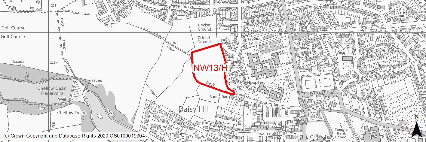
Site location
Regional City - Bradford NW
Ward
Toller
Site description
Sloping field with access from Milmoor Close.
Proposed Allocation
Housing
SHLAA referencce
NW/031B
Indicative no. dwellings
58
Site area (Gross) (ha)
2.22
Ownership
Private
Delivery timescales
Developable (6-10 years)
Type (PDL/Greenfield)
Greenfield
Green Belt
Yes
Flood Zone
Flood Zone 1
Potential site access
Access available from Millmoor Close but total number of dwellings served off Bootham Crescent will need to be 200 or less as this is a cul-de-sac.
Public Transport Accessibility
The site is not located near to frequent bus or rail services.
Sustainability Appraisal
The site could deliver a major positive effect for residents on the health SA Objective as a result of being within the target distances for all necessary health facilities. Minor positive effects were predicted for nearly all other socio-economic themed SA Objectives due to the benefits of new residential development for the local economy as well as the location of the site in relation to transport links, local services and amenities, education facilities and employment areas.
As a greenfield and Green Belt site containing trees, the development has been predicted to result in minor adverse effects on most natural environment themed SA Objectives.
Habitats Regulations Assessment
This site falls within 7km of the South Pennine Moors SPA/SAC a HRA must be undertaken to ensure there are no significant effects on these protected sites in terms of recreational pressures. Developments within these zones must comply with Policy SP11; an SPD is being produced to provide further guidance.
Green Belt
See individual Green Belt site assessment in the accompanying report.
Constraints and Opportunities
• The site lies within the green belt.
• Further work is required to establish the ecological value of the area and the mitigation measures which may be required.
• Not within the S Pennine Moors SPA / SAC however within Zone C (within 7KM) which requires consideration of potential impacts relating to recreation pressures.
Development considerations
• Scheme design should aim through the use of new planting, soft landscaping and buffer zones to minimise landscape impact.
• Planting along the western boundaries will be required to provide a new strong edge to the built up area.
• Scheme will need to assess and mitigate impacts on wildlife and incorporate on or off site contributions to support protected species.
Conclusion/Summary
Although situated within the green belt, the site lies in a sustainable location and could be developed in a way which minimises landscape and green belt impact and is therefore suitable for residential development.
(1) NW14/HC - Chellow Lane
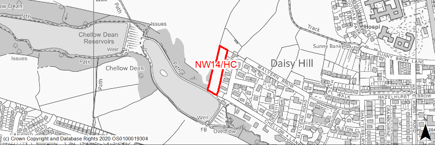
Site location
Regional City - Bradford NW
Ward
Heaton
Site description
Sloping grassland bounded by mature trees to rear of existing homes. Has outline planning permission for 6 homes.
Proposed Allocation
Housing
SHLAA referencce
NW/032
Indicative no. dwellings
6
Site area (Gross) (ha)
0.43
Ownership
Private
Delivery timescales
Deliverable (0-5 years)
Type (PDL/Greenfield)
Greenfield
Green Belt
No
Flood Zone
Flood Zone 1
Potential site access
Access from Chellow Lane.
Public Transport Accessibility
Site is approximately 600m from bus stops offering frequent services.
Sustainability Appraisal
The site could deliver a major positive effect for residents on the education SA Objective as a result of being within the target distances for both primary and secondary education facilities. Minor positive effects were predicted for nearly all other socio-economic themed SA Objectives due to the benefits of new residential development for the local economy as well as the location of the site in relation to transport links, local services and amenities, health facilities and employment areas. No major adverse effects have been predicted for the site, but minor adverse effects were predicted for a range of natural environment themed SA Objectives, primarily as a result of the impacts of new development on a 100% greenfield site adjoining an LWS, Chellow Dean Woods and Reservoir. The site is adjacent to Chellow Dean Reservoir and within 50m of Chellow Dean Beck, so careful consideration would be required around protecting the water quality. There is a Grade II Listed Building 20m south-east of the site, the setting of which could be adversely affected by new development here.
Habitats Regulations Assessment
This site falls within 7km of the South Pennine Moors SPA/SAC a HRA must be undertaken to ensure there are no significant effects on these protected sites in terms of recreational pressures. Developments within these zones must comply with Policy SP11; an SPD is being produced to provide further guidance.
Green Belt
N/A – Site not within the Green Belt.
Constraints and Opportunities
• Grade II Listed Building - Reservoir Lodge, adjoins the site at its far southern edge.
• The site includes two small areas designated as group TPO - one at southern end where access would be obtained and one at the NW edge.
• Lies within a draft Bradford GI Corridor.
• Not within the S Pennine Moors SPA / SAC however within Zone C (within 7KM) which requires consideration of potential impacts relating to recreation pressures.
• No priority habitats within the site but re protected species, bat alert layer covers the site.
• Small areas within the site are identified as 1/1000 year flood risk.
• The site is adjacent to Chellow Dean Reservoir and within 50m of Chellow Dean Beck, so careful consideration would be required around protecting the water quality.
Development considerations
• Development design and layout should seek to protect the setting of listed buildings.
• Development should where possible seek to retain protected trees and include additional new planting.
Conclusion/Summary
The site lies in a sustainable location within Pool 1 (lowest flood risk and within the urban area) and, subject to a sensitive design is suitable for residential development. The site has outline planning permission.
(4) NW15/H - Former Merrivale Arms Public House and Surrounds, Merrivale Road, Allerton
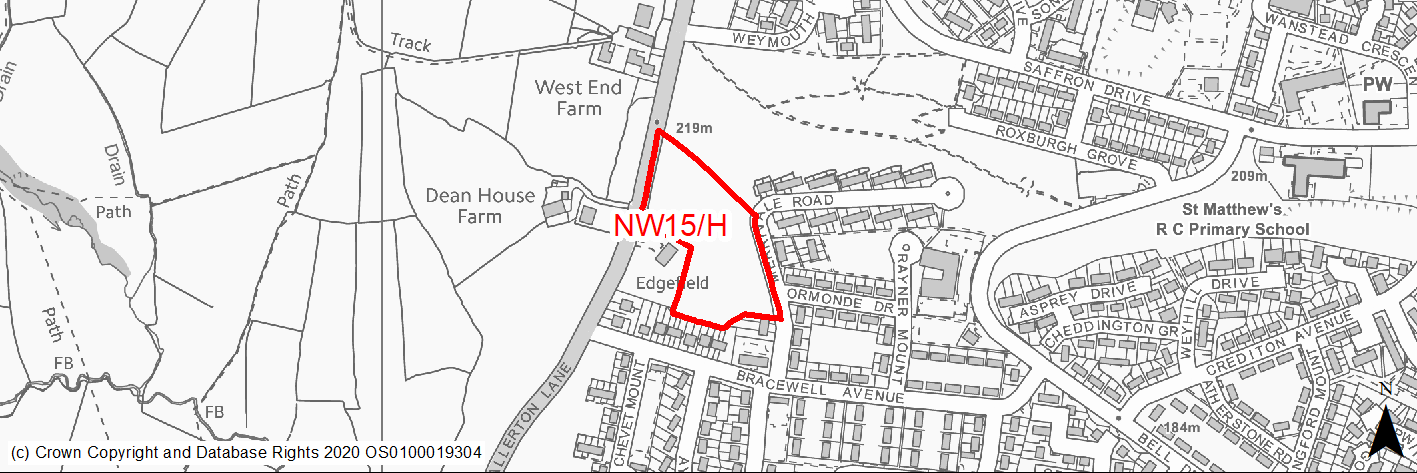
Site location
Regional City - Bradford NW
Ward
Thornton and Allerton
Site description
Slightly sloping maintained land. Site of former Merivale Arms.
Proposed Allocation
Housing
SHLAA referencce
NW/040
Indicative no. dwellings
54
Site area (Gross) (ha)
1.34
Ownership
Council
Delivery timescales
Developable (6-10 years)
Type (PDL/Greenfield)
Greenfield
Green Belt
No
Flood Zone
Flood Zone 1
Potential site access
Access is available from Merrivale Road and Allerton Lane but Merrivale would be the preferred option.
Public Transport Accessibility
Site within 400m of a High Frequency Bus Network
Sustainability Appraisal
See individual Sustainability Appraisal site comment in the accompanying report.
Habitats Regulations Assessment
This site falls within 7km of the South Pennine Moors SPA/SAC a HRA must be undertaken to ensure there are no significant effects on these protected sites in terms of recreational pressures. Developments within these zones must comply with Policy SP11; an SPD is being produced to provide further guidance.
Green Belt
N/A – Site not within the Green Belt.
Constraints and Opportunities
• Although a greenfield site it would have no significant impacts in relation to heritage, landscape or ecology. However:
• Not within the S Pennine Moors SPA / SAC however within Zone C (within 7KM) which requires consideration of potential impacts relating to recreation pressures.
• Several small areas within the site are identified as being subject to risk of surface water flooding - the draft SFRA does not consider the risk significant.
Development considerations
• Development will need to consider how to mitigate any surface water flood risk issues.
Conclusion/Summary
The site lies in a sustainable location within Pool 1 (lowest flood risk and within the urban area) and is considered suitable for residential development.
(1) NW16/H - Allerton Lane/Chevet Mount (1)
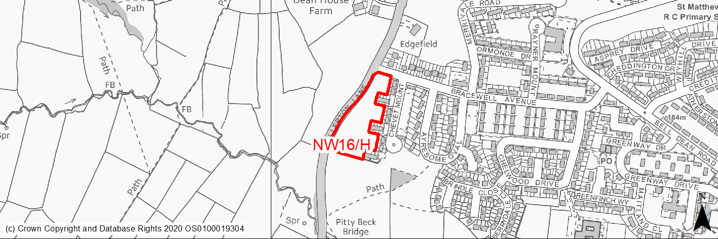
Site location
Regional City - Bradford NW
Ward
Thornton and Allerton
Site description
Mown grass bordering houses.
Proposed Allocation
Housing
SHLAA referencce
NW/041a
Indicative no. dwellings
28
Site area (Gross) (ha)
0.91
Ownership
Private
Delivery timescales
Developable (6-10 years)
Type (PDL/Greenfield)
Greenfield
Green Belt
No
Flood Zone
Flood Zone 1
Potential site access
Site can be accessed - previously approved as a care home
Public Transport Accessibility
Site within 400m of a High Frequency Bus Network
Sustainability Appraisal
No significant adverse effects predicted for the site. Minor adverse effects predicted for most natural environment themed SA Objectives, primarily as a result of the effects associated with development on greenfield. The site is well located to provide residents with good access to key services and amenities including shops, as well as jobs, cultural spaces, and buses, with particularly good access to schools and health facilities.
Habitats Regulations Assessment
This site falls within 7km of the South Pennine Moors SPA/SAC a HRA must be undertaken to ensure there are no significant effects on these protected sites in terms of recreational pressures. Developments within these zones must comply with Policy SP11; an SPD is being produced to provide further guidance.
Green Belt
N/A – Site not within the Green Belt.
Constraints and Opportunities
• A former RUDP housing allocation
• Priority species - bat alert layer covers the southern 1/2 of the site.
• Very small area within site identified as subject to flooding but no issues raised in draft SFRA
• Not within the S Pennine Moors SPA / SAC however within Zone C (within 7KM) which requires consideration of potential impacts relating to recreation pressures.
Development considerations
• Development will need to consider how to mitigate any surface water flood risk issues.
• Sensitive design required, landscaping and planting to soften development edge and integrate with existing rights of way and open spaces.
Conclusion/Summary
Although a greenfield site, it lies in a sustainable location within Pool 1 (lowest flood risk and within the urban area) and is considered suitable for residential development.
(1) NW17/H - Allerton Lane/Chevet Mount (2)
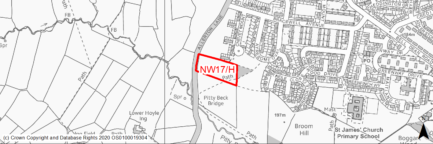
Site location
Regional City - Bradford NW
Ward
Thornton and Allerton
Site description
Mown grass adjoining and to the south of existing houses.
Proposed Allocation
Housing
SHLAA referencce
NW/041b
Indicative no. dwellings
24
Site area (Gross) (ha)
0.76
Ownership
Private
Delivery timescales
Developable (6-10 years)
Type (PDL/Greenfield)
Greenfield
Green Belt
No
Flood Zone
Flood Zone 1
Potential site access
Site can be accessed - previously approved as a care home
Public Transport Accessibility
Site within 400m of a High Frequency Bus Network
Sustainability Appraisal
Potential major adverse impacts associated with development on a large greenfield site. Potential minor adverse impacts on natural environment objectives due to development on greenfield site that falls entirely within Natural England’s GI network. Likely positive impacts on socioeconomic and housing objectives. Excellent access to education and health facilities.
Habitats Regulations Assessment
This site falls within 7km of the South Pennine Moors SPA/SAC a HRA must be undertaken to ensure there are no significant effects on these protected sites in terms of recreational pressures. Developments within these zones must comply with Policy SP11; an SPD is being produced to provide further guidance.
Green Belt
N/A – Site not within the Green Belt.
Constraints and Opportunities
• A former RUDP housing allocation.
• The site adjoins a sensitive area of designated woodland of habitat and ecological value.
• Priority species - bat alert layer covers the site.
• Very small area within site identified as subject to flooding but no issues raised in draft SFRA.
• Not within the S Pennine Moors SPA / SAC however within Zone C (within 7KM) which requires consideration of potential impacts relating to recreation pressures.
Development considerations
• Careful design required to mitigate and if possible compliment the ecological value of adjoining land.
• Development will need to consider how to mitigate any surface water flood risk issues.
• Sensitive design required, landscaping and planting to soften development edge and integrate with existing rights of way and open spaces.
Conclusion/Summary
Although a greenfield site requiring sensitive design, it lies in a sustainable location within Pool 1 (lowest flood risk and within the urban area) and is considered suitable for residential development.
(3) NW18/H - Haworth Road, Playing fields, Heaton
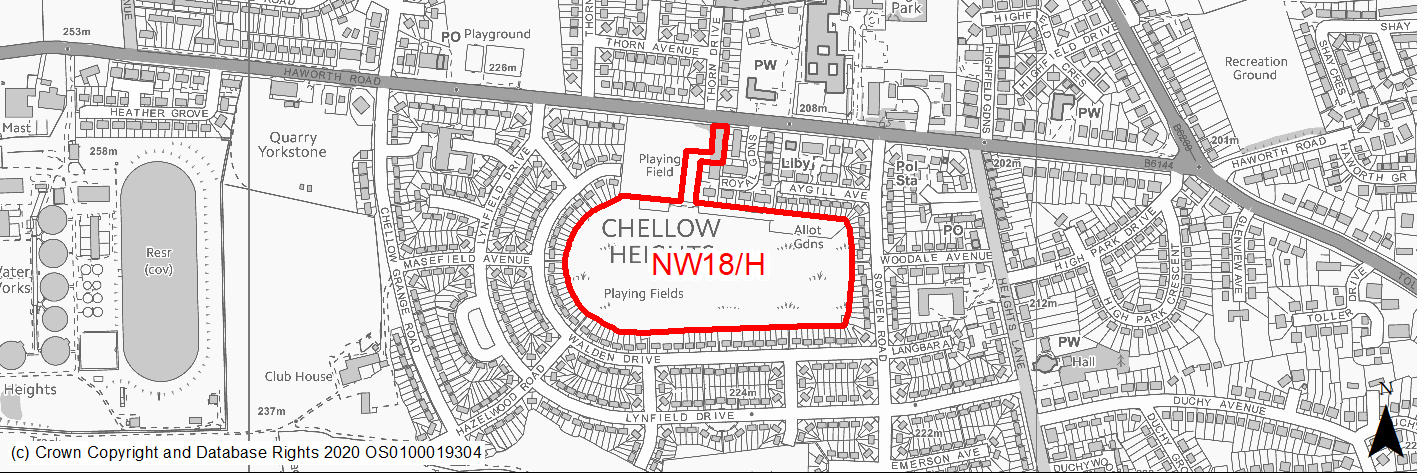
Site location
Regional City - Bradford NW
Ward
Heaton
Site description
Level playing fields with football nets and play area and under used recreation space.
Proposed Allocation
Housing
SHLAA referencce
NW/046
Indicative no. dwellings
80
Site area (Gross) (ha)
6.48
Ownership
Council
Delivery timescales
Developable (6-10 years)
Type (PDL/Greenfield)
Greenfield
Green Belt
No
Flood Zone
Flood Zone 1
Potential site access
Site can be accessed from Haworth Road and Walden Drive.
Public Transport Accessibility
Site within 400m of a High Frequency Bus Network
Sustainability Appraisal
The site could deliver major positive effects for residents on both the health and education SA Objectives as a result of being within the target distances for all necessary health facilities and centres for primary and secondary education. Minor positive effects were predicted for nearly all other socio-economic themed SA Objectives due to the benefits of new residential development for the local economy as well as the location of the site in relation to transport links, local services and amenities, and employment areas. No major adverse effects have been predicted for the site, but minor adverse effects were predicted for a range of natural environment themed SA Objectives, primarily as a result of the impacts of new development on a 100% greenfield site containing trees. Approximately 30% of the site is at low risk of surface water flooding and there are a few very limited areas at medium and high risk, but given the size of the site in relation to these areas, it is expected that it could be avoided through the careful layout of the development.
Habitats Regulations Assessment
This site falls within 7km of the South Pennine Moors SPA/SAC a HRA must be undertaken to ensure there are no significant effects on these protected sites in terms of recreational pressures. Developments within these zones must comply with Policy SP11; an SPD is being produced to provide further guidance.
Green Belt
N/A – Site not within the Green Belt.
Constraints and Opportunities
• Designated as various forms of greenspace in RUDP.
• Small group TPO at NE corner of site.
• Part of site is covered by areas of identified to be at risk of surface water flooding.
• Not within the S Pennine Moors SPA / SAC however within Zone C (within 7KM) which requires consideration of potential impacts relating to recreation pressures.
Development considerations
• The site is allocated on the basis that only part is developed for housing with the remaining area forming enhanced recreation open space;
• Development will also need to provide off site contributions to compensate for the loss of the existing land. There may be opportunities for enhanced children’s play space on the adjoining area to the west.
• Development will need to consider how to mitigate any surface water flood risk issues.
• Replacement planting may be required to compensate for the loss of any trees and the scheme should incorporate new tree planting and landscaping.
Conclusion/Summary
Although a greenfield site, it lies in a sustainable location within Pool 1 (lowest flood risk and within the urban area) and is considered suitable for residential development.
(18) NW19/H - Bingley Road/Long Lane, Heaton
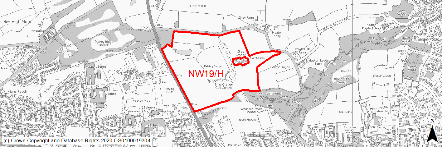
Site location
Regional City - Bradford NW
Ward
Heaton
Site description
Undulating land within the green belt in use as golf driving range and 9 hole golf course. Sports grounds lie to the south.
Proposed Allocation
Housing
SHLAA referencce
NW/049
Indicative no. dwellings
300
Site area (Gross) (ha)
20.33
Ownership
Private
Delivery timescales
Developable (6-10 years)
Developable (Years 11-15)
Type (PDL/Greenfield)
95% Greenfield 5% PDL if include club house and car parking as PDL.
Green Belt
Yes
Flood Zone
Flood Zone 1
Potential site access
Site can be accessed off Bingley Road and Long Lane
Public Transport Accessibility
Site within 400m of a High Frequency Bus Network
Sustainability Appraisal
See individual Sustainability Appraisal site comment in the accompanying report.
Habitats Regulations Assessment
This site falls within 7km of the South Pennine Moors SPA/SAC a HRA must be undertaken to ensure there are no significant effects on these protected sites in terms of recreational pressures. Developments within these zones must comply with Policy SP11; an SPD is being produced to provide further guidance.
Green Belt
See individual Green Belt site assessment in the accompanying report.
Constraints and Opportunities
• Undulating parkland within the green belt in use as golf driving range and 9-hole golf course.
• There are no wildlife designations within the site but parts of the site are identified as priority habitats and most of the site lies within a bat alert layer.
• A Local Wildlife Site and Ancient Woodland adjoins the site at its SE section.
• There is one group TPO in the central northern part of the site one at the NW site boundary.
• The northern and eastern parts of the site are located in a high risk area for former coal mining
• A small area within the site is an area of landfill and the site lies within the 150M buffer zone of a landfill area to the south
• Small fringe of site at western edge lies within the 50M buffer zone for the grade II listed Hallmark Cards Factory however assessment suggests that there would be no heritage impacts.
• Not within the S Pennine Moors SPA / SAC however within Zone C (within 7KM) which requires consideration of potential impacts relating to recreation pressures.
Development considerations
• Given its parkland setting a high quality a relatively low density scheme is required.
• Site design and layout should ensure that existing landscape features of value and existing areas of trees are retained, enhanced and where possible strengthened with additional planting.
• Existing lines of trees along Long Lane and Bingley Road should wherever possible be retained.
• Therefore built development should be focused on the central and western parts of the site.
• Planting / buffer zones should be incorporated particularly in the southern sections which should be carefully designed to compliment and enhance the woodland, habitats and ecology of the adjoining protected areas.
• Scheme design should incorporate measures to enhance biodiversity and to conserve and build on the existing wildlife corridors and habitats that adjoin and pass through the site.
• Surveys are required to investigate and mitigate for any issues relating to former coal mining and landfill activities.
Conclusion/Summary
Although situated within the green belt, the site lies in a sustainable location and could be developed in a way which minimises landscape and green belt impact and is therefore suitable for residential development.
(4) NW20/H - Former Reservoir and Derelict Pumping Station, Carlisle Road
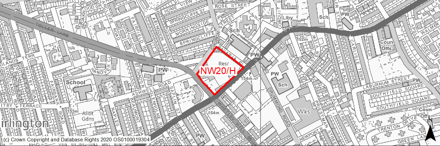
Site location
Regional City - Bradford NW
Ward
Manningham
Site description
Vacant former covered reservoir and derelict pumping station surrounded by high walls. Lower land occupied by derelict pub, shops and warehouse currently used as cash and carry storage and hand car wash.
Proposed Allocation
Housing
SHLAA referencce
NW/052
Indicative no. dwellings
43
Site area (Gross) (ha)
1.07
Ownership
Private/Council
Delivery timescales
Developable (6-10 years)
Type (PDL/Greenfield)
PDL
Green Belt
No
Flood Zone
Flood Zone 1
Potential site access
Access could be gained from Church Street, subject to satisfactory visibility.
Public Transport Accessibility
Site within 400m of a High Frequency Bus Network
Sustainability Appraisal
Significant adverse effect predicted for the air quality SA Objective due to the site being partially within the CAZ. No other significant adverse effects predicted. Development at the site would be an opportunity to deliver biodiversity net gains, improvements to the local townscape character, and new investment for the Listed Building within the site – although it is somewhat uncertain whether the Listed Building (which appears to have fallen into disrepair) would be reused and invested in, or demolished. The site is well located to provide residents with good access to shops, jobs, buses, and cultural spaces, with particularly good access to schools and health facilities.
Habitats Regulations Assessment
This site is beyond the zones of influence of the South Pennine Moors SPA/SAC and is therefore unlikely to have any significant effects, a HRA is not required.
Green Belt
N/A – Site not within the Green Belt.
Constraints and Opportunities
• A brownfield site whose development would contribute to improvement of one of the district's priority regeneration areas and secure a use for the currently derelict listed building.
• A small strip of the site lies within draft Clean Air Zone and the site adjoins Carlisle Road / Whetley Hill which has been identified as having high NO2 levels.
Development considerations
• Development will need to consider how to mitigate any air quality issues.
• Design and layout should ensure that any impacts on the listed building is avoided / mitigated.
Conclusion/Summary
A brownfield site in a sustainable location within Pool 1 (lowest flood risk and within the urban area) where development could improve and regenerate the area. Suitable for residential development.
(2) NW21/H - Whetley Mills
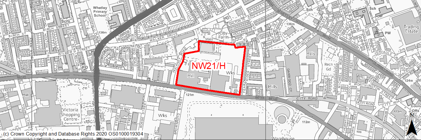
Site location
Regional City - Bradford NW
Ward
Thornton and Allerton
Site description
Historic mill and adjoining land and structures in partial use but with parts substantially derelict and at risk.
Proposed Allocation
Housing
SHLAA referencce
NW/054
Indicative no. dwellings
250
Site area (Gross) (ha)
5.08
Ownership
Private
Delivery timescales
Developable (6-10 years)
Developable (11-15 years)
Type (PDL/Greenfield)
Mixed though predominantly PDL
Green Belt
No
Flood Zone
Flood Zone 1
Potential site access
Site can be accessed from existing roads.
Public Transport Accessibility
Site within 400m of a High Frequency Bus Network
Sustainability Appraisal
See individual Sustainability Appraisal site comment in the accompanying report.
Habitats Regulations Assessment
This site is beyond the zones of influence of the South Pennine Moors SPA/SAC and is therefore unlikely to have any significant effects, a HRA is not required.
Green Belt
N/A – Site not within the Green Belt.
Constraints and Opportunities
• An opportunity for an exemplar development which would secure and conserve the existing historic mill and act as a catalyst for local regeneration.
• The mill and most of the site is grade II listed.
• Site lies within draft Clean Air Zone.
• There are several areas within the site which are identified as being subject to 1 in 30 or 1 in 100 year surface water flooding.
• Priority habitats - a small part of the site within the eastern section is identified as deciduous woodland on the priority habitat inventory. Priority species - all of the site is within a bat alert area.
Development considerations
• Design and layout should ensure that any impacts on the listed buildings are avoided / mitigated.
• A high quality scheme is required which retains and conserves existing listed features.
• Development will need to consider how to mitigate any air quality and surface water flood risk issues.
• The scheme will need to retain and enhance the areas of woodland and habitat value within the site.
Conclusion/Summary
An important regeneration opportunity, a sustainable location within Pool 1 (lowest flood risk and within the urban area) where development could improve the area and conserve important historic buildings.
(1) NW22/H - Alton Grove, Frizinghall
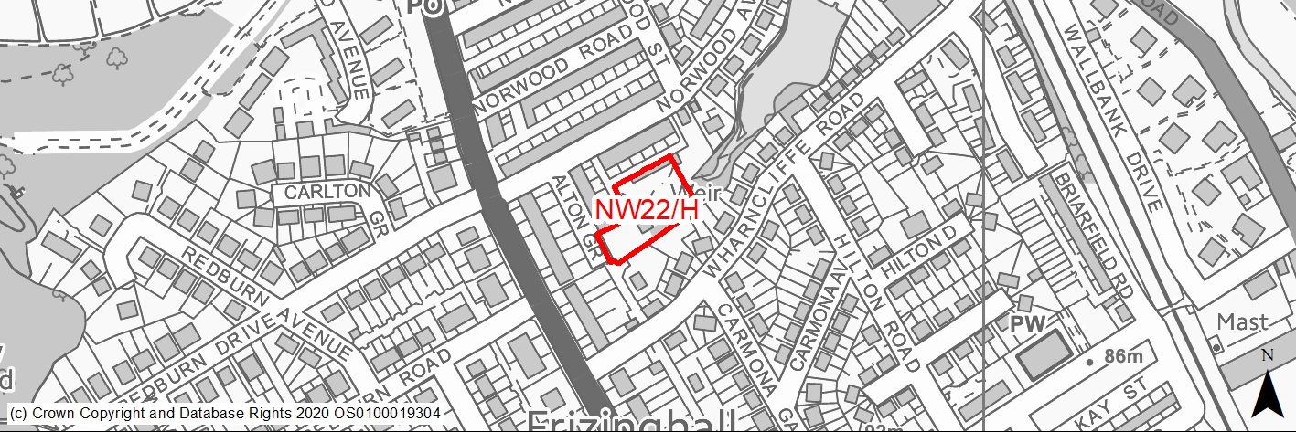
Site location
Regional City - Bradford NW
Ward
Shipley
Site description
Works building and garages. Site previously had detailed planning permission for 4 units.
Proposed Allocation
Housing
SHLAA referencce
NW/066
Indicative no. dwellings
5
Site area (Gross) (ha)
0.26
Ownership
Private
Delivery timescales
Developable (6-10 years)
Type (PDL/Greenfield)
PDL
Green Belt
No
Flood Zone
Flood Zone 1
Potential site access
Access could be served from Wharncliffe Road and Alton Grove.
Public Transport Accessibility
Site within 400m of a High Frequency Bus Network
Sustainability Appraisal
See individual Sustainability Appraisal site comment in the accompanying report.
Habitats Regulations Assessment
This site falls within 7km of the South Pennine Moors SPA/SAC a HRA must be undertaken to ensure there are no significant effects on these protected sites in terms of recreational pressures. Developments within these zones must comply with Policy SP11; an SPD is being produced to provide further guidance.
Green Belt
N/A – Site not within the Green Belt.
Constraints and Opportunities
• Almost all of the site is identified as having 1/1000 year surface water flood risk and a significant part 1/100 years or 1/30 years.
• Site lies within draft Clean Air Zone.
• Site covered by a group TPO (although trees only cover parts of the site).
• Not within the S Pennine Moors SPA / SAC however within Zone C (within 7KM) which requires consideration of potential impacts relating to recreation pressures.
• No priority habitats within the site however re priority species - bat alert layer covers the site.
• Lies within a draft Bradford Green Infrastructure Corridor.
Development considerations
• Development will need to consider how to mitigate any air quality and surface water flood risk issues.
• Development should where possible seek to retain protected trees and include additional new planting.
Conclusion/Summary
The site, which previously has planning permission for 4 homes, lies in a sustainable location within the urban area and, subject to mitigation of flood risk and air quality issues is suitable for residential development.
(2) NW23/H - Church Street, Manningham
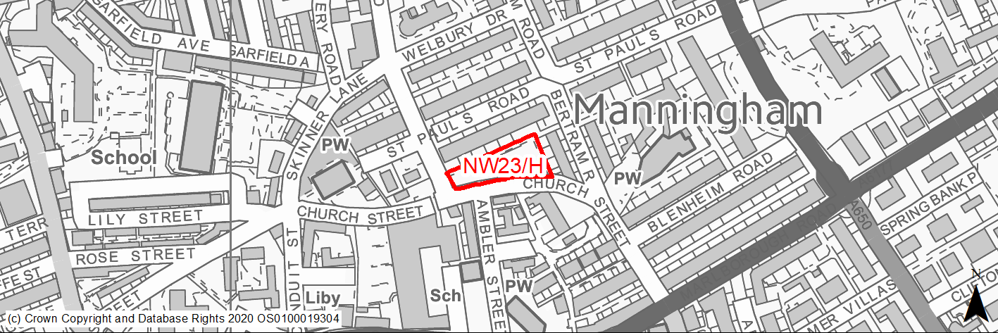
Site location
Regional City - Bradford NW
Ward
Manningham
Site description
Cleared site formerly retail, surrounded by houses.
Proposed Allocation
Housing
SHLAA referencce
NW/073
Indicative no. dwellings
10
Site area (Gross) (ha)
0.23
Ownership
Private
Delivery timescales
Deliverable (0-5 years)
Type (PDL/Greenfield)
PDL
Green Belt
No
Flood Zone
Flood Zone 1
Potential site access
Access could be gained from Church Street,
Public Transport Accessibility
Site within 400m of a High Frequency Bus Network
Sustainability Appraisal
Significant adverse effect predicted for air quality SA Objective due to the site being in a CAZ. No other significant adverse effects predicted. The site would be a good opportunity to deliver biodiversity net gains and improvements to the local character, as well as to the setting of St Paul’s Conservation Area and nearby Listed Buildings. The site is well located to provide residents with good access to shops, jobs, cultural spaces, and buses, with particularly good access to schools and health facilities.
Habitats Regulations Assessment
This site is beyond the zones of influence of the South Pennine Moors SPA/SAC and is therefore unlikely to have any significant effects, a HRA is not required.
Green Belt
N/A – Site not within the Green Belt.
Constraints and Opportunities
• Development of an untidy cleared brownfield site development would contribute to improvement and regeneration and potentially enhance the St Paul's Conservation Area and setting of adjoining listed buildings.
• Site lies within a draft Clean Air Zone.
Development considerations
• Design and layout should ensure that any impacts on the Conservation Area and listed buildings are avoided / mitigated.
• Development will need to consider how to mitigate any air quality issues.
Conclusion/Summary
The site lies in a sustainable location within Pool 1 (lowest flood risk and within the urban area. Subject to a sensitive design it is suitable for residential development and could help to improve and regenerate the area.
(1) NW24/H - Rayner Mount Allerton
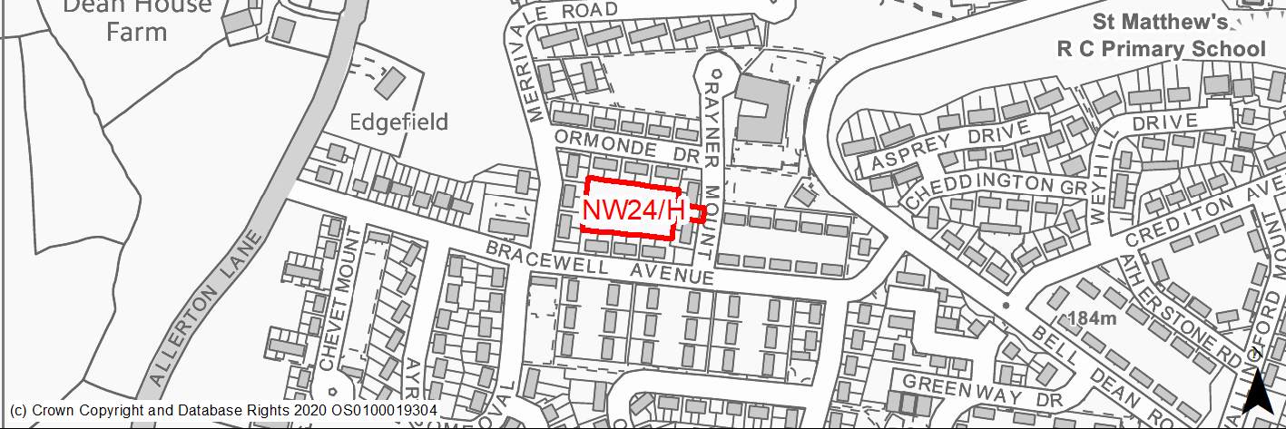
Site location
Regional City - Bradford NW
Ward
Thornton and Allerton
Site description
Level grassed area behind houses. Unused with tipping
Proposed Allocation
Housing
SHLAA referencce
NW/080
Indicative no. dwellings
6
Site area (Gross) (ha)
0.24
Ownership
Council
Delivery timescales
Developable (6-10 years)
Type (PDL/Greenfield)
Greenfield
Green Belt
No
Flood Zone
Flood Zone 1
Potential site access
Site can be accessed from Rayner Mount.
Public Transport Accessibility
Site within 400m of a High Frequency Bus Network
Sustainability Appraisal
No significant adverse effects predicted. Minor adverse effects predicted for most natural environment themed SA Objectives, primarily as a result of the effects associated with development on greenfield. The site is well located to provide residents here with good access to shops, jobs, buses, and cultural spaces, with particularly good access to schools and health facilities.
Habitats Regulations Assessment
This site falls within 7km of the South Pennine Moors SPA/SAC a HRA must be undertaken to ensure there are no significant effects on these protected sites in terms of recreational pressures. Developments within these zones must comply with Policy SP11; an SPD is being produced to provide further guidance.
Green Belt
N/A – Site not within the Green Belt.
Constraints and Opportunities
• An opportunity to provide housing and better use an area currently subject to tipping.
Development considerations
• N/A
Conclusion/Summary
The site lies in a sustainable location and its development would improve the local area.
(1) NW25/H - Former Nightclub and Operational Stone Yard, Belvedere Terrace
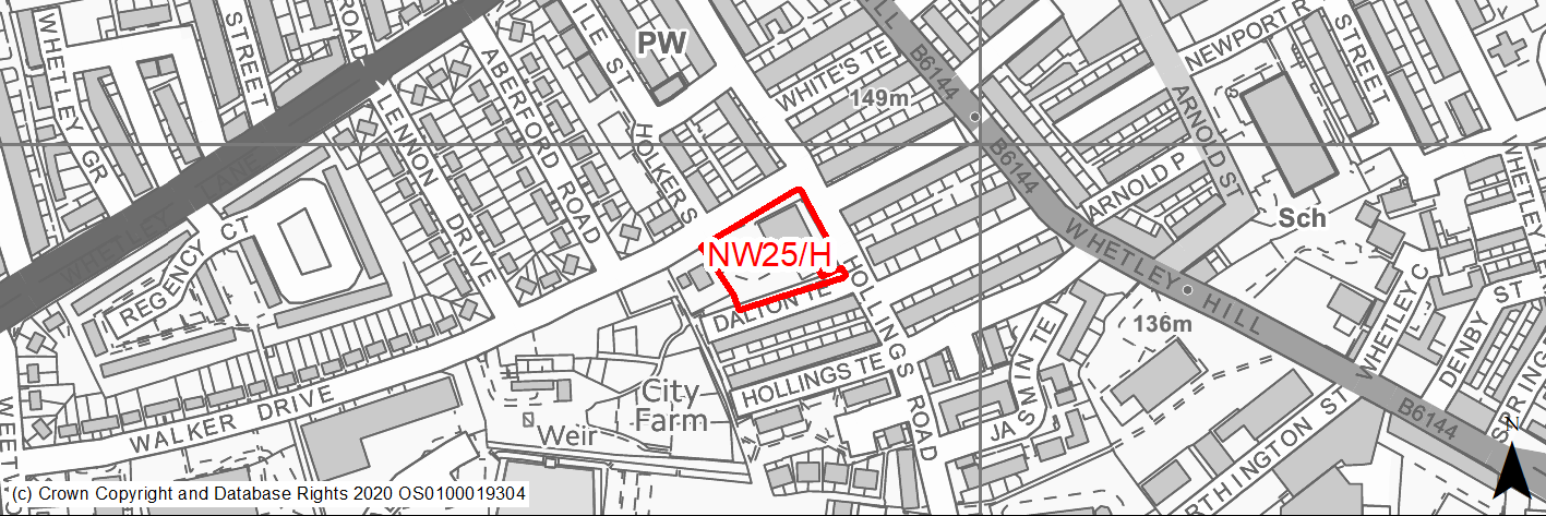
Site location
Regional City - Bradford NW
Ward
Clayton and Fairweather Green
Site description
Former night club building and operational stone yard.
Proposed Allocation
Housing
SHLAA referencce
NW/084
Indicative no. dwellings
15
Site area (Gross) (ha)
0.33
Ownership
Private
Delivery timescales
Developable (6-10 years)
Type (PDL/Greenfield)
PDL
Green Belt
No
Flood Zone
Flood Zone 1
Potential site access
Access is available from Belvedere Terrace.
Public Transport Accessibility
Site within 400m of a High Frequency Bus Network
Sustainability Appraisal
Significant adverse effect predicted for the air quality SA Objective as a result of the site being within the CAZ. No other significant adverse effects predicted. The site would be a good opportunity to deliver biodiversity net gains and improvements to the local character. The site is well located to provide residents with good access to jobs, shops, buses, and cultural spaces, with particularly good access to schools and health facilities.
Habitats Regulations Assessment
This site is beyond the zones of influence of the South Pennine Moors SPA/SAC and is therefore unlikely to have any significant effects, a HRA is not required.
Green Belt
N/A – Site not within the Green Belt.
Constraints and Opportunities
• A brownfield site whose development would contribute to improvement and regeneration of the area.
• Site lies within a draft CAZ - need to address air quality issues.
• There are some active uses on the site.
Development considerations
• Development will need to consider how to mitigate any air quality issues.
Conclusion/Summary
A brownfield site in a sustainable location within Pool 1 (lowest flood risk and within the urban area) where development could improve and regenerate the area. Suitable for residential development.
(1) NW26/H - Former Storage Yard, Thornton Road, Fairweather Green
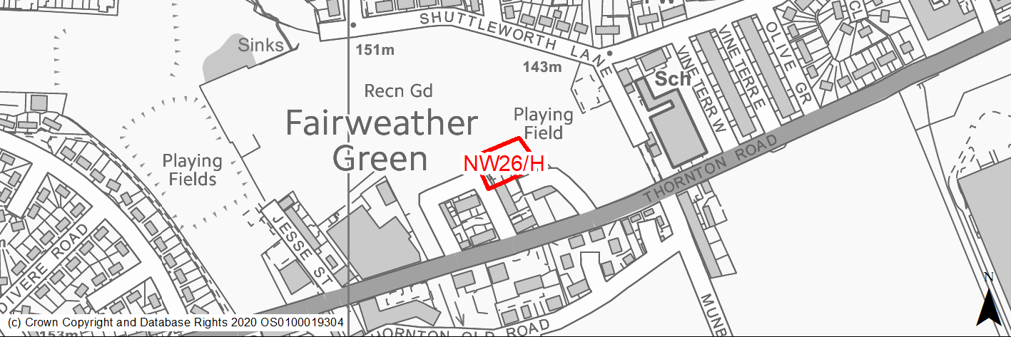
Site location
Regional City - Bradford NW
Ward
Clayton and Fairweather Green
Site description
Former storage yard.
Proposed Allocation
Housing
SHLAA referencce
NW/087
Indicative no. dwellings
5
Site area (Gross) (ha)
0.23
Ownership
Private
Delivery timescales
Developable (6-10 years)
Type (PDL/Greenfield)
PDL
Green Belt
No
Flood Zone
Flood Zone 1
Potential site access
Site is accessed from Belshaw Street.
Public Transport Accessibility
Site within 400m of a High Frequency Bus Network
Sustainability Appraisal
No significant adverse effects predicted for the site. Minor adverse effects predicted for water resources and air quality SA Objectives, as predicted for nearly all sites. This small PDL site would be a good opportunity to deliver biodiversity net gains and improvements to the local townscape character. The site is well located to provide residents with good access to jobs, shops, cultural spaces, buses, and health facilities, with particularly good access to schools.
Habitats Regulations Assessment
This site falls within 7km of the South Pennine Moors SPA/SAC a HRA must be undertaken to ensure there are no significant effects on these protected sites in terms of recreational pressures. Developments within these zones must comply with Policy SP11; an SPD is being produced to provide further guidance.
Green Belt
N/A – Site not within the Green Belt.
Constraints and Opportunities
• A brownfield site whose development would contribute to improvement of the area.
• Within 150 & 250M buffer zone of 2 small former landfill areas to the N and S.
• Not within the S Pennine Moors SPA however within Zone C (within 7KM) which requires consideration of potential impacts relating to recreation pressures.
• Priority species - a small part of the NW corner of the site is within a bat alert area.
Development considerations
• Surveys required to investigate and mitigate for any issues relating to former landfill activities.
Conclusion/Summary
The site lies in a sustainable location within Pool 1 (lowest flood risk and within the urban area) and is considered suitable for residential development.
(3) NW27/H - 74 Frizinghall Road
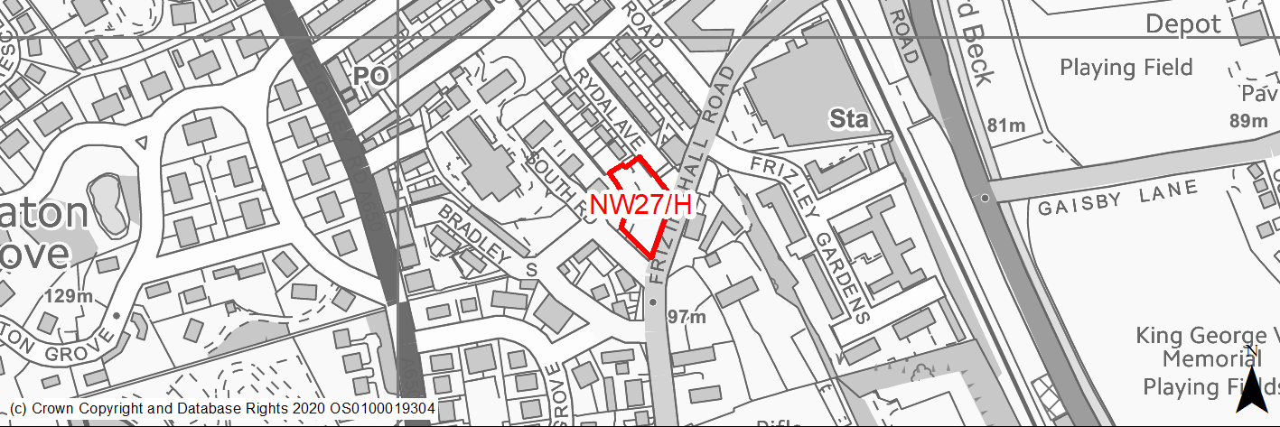
Site location
Regional City - Bradford NW
Ward
Heaton
Site description
Former car park to the Black Swann PH - Site permission for 6 units.
Proposed Allocation
Housing
SHLAA referencce
NW/088
Indicative no. dwellings
6
Site area (Gross) (ha)
0.17
Ownership
Private
Delivery timescales
Developable (6-10 years)
Type (PDL/Greenfield)
PDL
Green Belt
No
Flood Zone
Flood Zone 1
Potential site access
Access from Frizinghall Road and Rydal Avenue. Design should avoid access being taken from points near / at the junction between these roads.
Public Transport Accessibility
Site within 400m of a High Frequency Bus Network
Sustainability Appraisal
See individual Sustainability Appraisal site comment in the accompanying report.
Habitats Regulations Assessment
This site falls within 7km of the South Pennine Moors SPA/SAC a HRA must be undertaken to ensure there are no significant effects on these protected sites in terms of recreational pressures. Developments within these zones must comply with Policy SP11; an SPD is being produced to provide further guidance.
Green Belt
N/A – Site not within the Green Belt.
Constraints and Opportunities
• Site lies within draft Clean Air Zone.
• The eastern half of the site is identified as having 1/1000 year surface water flood risk with some parts higher 1/30 year risk.
• Grade 11 listed buildings lie just to the east of the site within the 50M buffer zone.
• Site contains 2 areas identified as group TPO.
• The site lies within the 250M buffer zone of a landfill area ref 13ne25.
• No priority habitats within the site but re protected species - bat alert layer covers the site.
• Not within the S Pennine Moors SPA / SAC however within Zone C (within 7KM) which requires consideration of potential impacts relating to recreation pressures.
Development considerations
• Development will need to consider how to mitigate any air quality and surface water flood risk issues.
• Development should where possible seek to retain protected trees and include additional new planting.
• Development design and layout should seek to protect the setting of listed buildings.
• Surveys required to investigate and mitigate for any issues relating to former landfill activities.
• Access from Frizinghall Road and Rydal Avenue. Design should avoid access being taken from points near / at the junction between these roads.
Conclusion/Summary
The site, which previously has planning permission for 6 homes, lies in a sustainable location within the urban area and, subject to mitigation of flood risk and air quality issues and sensitive design is suitable for residential development.
(3) NW28/H - Patent Street, Manningham
Site location
Regional City - Bradford NW
Ward
Toller
Site description
Underused land, part green open area/part former storage area.
Proposed Allocation
Housing
SHLAA referencce
NW/099
Indicative no. dwellings
75
Site area (Gross) (ha)
1.35
Ownership
Private
Delivery timescales
Developable (6-10 years)
Type (PDL/Greenfield)
Mixed. Approx 35% PDL
Green Belt
No
Flood Zone
Flood Zone 1
Potential site access
Access is available from Patent Street and Silk Street - though both are adopted highway their conditions are substandard and do not meet the Council's current requirements and would therefore need improvement.
Public Transport Accessibility
Site within 400m of a High Frequency Bus Network
Sustainability Appraisal
No significant adverse effects predicted for the site. Minor adverse effects predicted for most natural environment themed SA Objectives, primarily as a result of the effects associated with development on open space and greenfield. The site is well located to provide residents with good access to shops, jobs, buses and cultural spaces, with particularly good access to schools and health facilities.
Habitats Regulations Assessment
This site is beyond the zones of influence of the South Pennine Moors SPA/SAC and is therefore unlikely to have any significant effects, a HRA is not required.
Green Belt
N/A – Site not within the Green Belt.
Constraints and Opportunities
• An opportunity for a quality scheme which could contribute to the regeneration of the area.
• Adjoins a conservation area and is within the buffer zone for Lister Mills Grade IIS ref 8/135 and Lilycroft Primary School.
• Part of the site is currently designated as recreation open space in the RUDP.
• Northern part of the site (the open space) lies within the 150M and 250M buffer zone of former landfill.
Development considerations
• Ideally the development should be progressed as part of a high quality comprehensive scheme which includes the adjoining listed structures and remaining vacant land around Lister Mill and enhances the area.
• Design and layout should ensure that any impacts on the Conservation Area and listed buildings are avoided / mitigated.
• •Although Patent Street and Silk Street are both adopted highway their conditions are substandard and do not meet the Council's current requirements and would therefore need improvement.
• There may be a need for development to include some new open space to compensate for the loss of the existing area.
Conclusion/Summary
A mixed greenfield / brownfield site in a sustainable location within Pool 1 (lowest flood risk and within the urban area) where development could improve and regenerate the area. Suitable for residential development.
(1) NW29/H - Chapel Lane, Allerton
Site location
Regional City - Bradford NW
Ward
Clayton and Fairweather Green
Site description
House and Garden.
Proposed Allocation
Housing
SHLAA referencce
NW/104
Indicative no. dwellings
5
Site area (Gross) (ha)
0.3
Ownership
Private
Delivery timescales
Developable (6-10 years)
Type (PDL/Greenfield)
PDL
Green Belt
No
Flood Zone
Flood Zone 1
Potential site access
Existing site access from Chapel Lane.
Public Transport Accessibility
Site within 400m of a High Frequency Bus Network
Sustainability Appraisal
See individual Sustainability Appraisal site comment in the accompanying report.
Habitats Regulations Assessment
This site falls within 7km of the South Pennine Moors SPA/SAC a HRA must be undertaken to ensure there are no significant effects on these protected sites in terms of recreational pressures. Developments within these zones must comply with Policy SP11; an SPD is being produced to provide further guidance.
Green Belt
N/A – Site not within the Green Belt.
Constraints and Opportunities
• Site adjoins Grade II listed building (Dixons Academy).
• Forms a small but inconsequential part of a large area designated as urban greenspace in the RUDP.
• Not within the S Pennine Moors SPA / SAC however within Zone C (within 7KM) which requires consideration of potential impacts relating to recreation pressures.
Development considerations
• Design and layout should ensure that any impacts on the listed buildings within and adjoining the site are avoided / mitigated.
Conclusion/Summary
The site lies in a sustainable location within Pool 1 (lowest flood risk and within the urban area) and is considered suitable for residential development.
(2) NW30/H - 7-9 Oak Avenue
Site location
Regional City - Bradford NW
Ward
Manningham
Site description
Derelict building - Permission approved October 2016 for partial demolition of building and new build of 6 houses and 6 apartments.
Proposed Allocation
Housing
SHLAA referencce
NW/111
Indicative no. dwellings
12
Site area (Gross) (ha)
0.17
Ownership
Private
Delivery timescales
Developable (6-10 years)
Type (PDL/Greenfield)
PDL
Green Belt
No
Flood Zone
Flood Zone 1
Potential site access
New access taken from oak Avenue.
Public Transport Accessibility
Site within 400m of a High Frequency Bus Network
Sustainability Appraisal
See individual Sustainability Appraisal site comment in the accompanying report.
Habitats Regulations Assessment
This site is beyond the zones of influence of the South Pennine Moors SPA/SAC and is therefore unlikely to have any significant effects, a HRA is not required.
Green Belt
N/A – Site not within the Green Belt.
Constraints and Opportunities
• Site lies within draft Clean Air Zone.
• Site lies within Manningham Conservation Area and a Listed building lies to the SW of the site but outside the 50M buffer zone.
• Site contains a v small group TPO on NW edge and a single TPO on site boundary.
• The central half of the site is identified as having 1/1000 year surface water flood risk.
Development considerations
• Development will need to consider how to mitigate any air quality and surface water flood risk issues.
• Development should where possible seek to retain protected trees and include additional new planting.
• Design and layout should ensure that any impacts on the Conservation Area and listed buildings are avoided / mitigated.
Conclusion/Summary
The site, which previously has planning permission for 12 homes, lies in a sustainable location within the urban area and, subject to mitigation of flood risk and air quality issues is suitable for residential development.
(2) NW31/H - Former Manningham Middle & Primary Schools, Manningham Lane
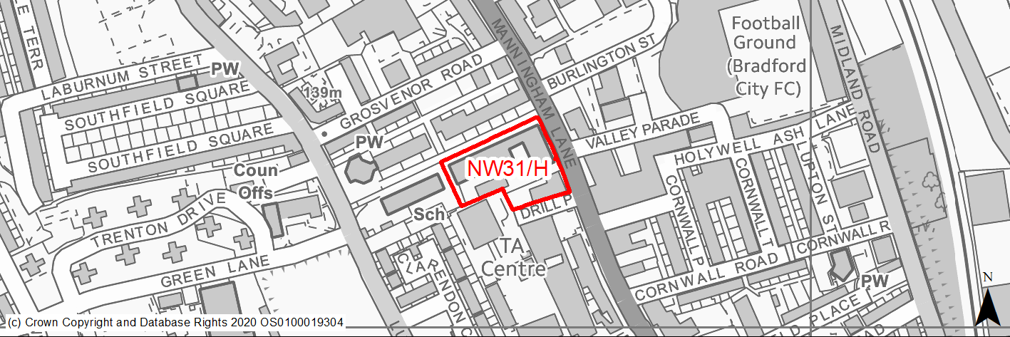
Site location
Regional City - Bradford NW
Ward
Manningham
Site description
Closed schools with development potential for a number of uses subject to permission, including residential. Buildings currently vacant
Proposed Allocation
Housing
SHLAA referencce
NW/123
Indicative no. dwellings
30
Site area (Gross) (ha)
0.87
Ownership
Private
Delivery timescales
Developable (6-10 years)
Type (PDL/Greenfield)
PDL
Green Belt
No
Flood Zone
Flood Zone 1
Potential site access
Access could be obtained from Manningham Lane using the existing entrance but this would need to be to an adequate width which would involve relocation of the sub station. An alternative would be to utilise Bell Vue however this is currently narrow and has on street parking therefore widening of this road could be necessary.
Public Transport Accessibility
Site within 400m of a High Frequency Bus Network and just beyond 800m of Forster Square Station.
Sustainability Appraisal
Significant adverse effect predicted for the air quality SA Objective as a result of the site being within the CAZ. No other significant adverse effects predicted. Development of this site would be a good opportunity to deliver biodiversity net gains, improvements to the local character as well as enhancements to the setting of the Apsley Crescent Conservation Area. It is expected that new development at the site would deliver new investment to better preserve the two Grade II Listed Buildings within the site, which currently appear to have fallen into disrepair. The site is well located to provide residents with good access to shops, jobs, buses, and cultural spaces, with particularly good access to health facilities and schools.
Habitats Regulations Assessment
This site is beyond the zones of influence of the South Pennine Moors SPA/SAC and is therefore unlikely to have any significant effects, a HRA is not required.
Green Belt
N/A – Site not within the Green Belt.
Constraints and Opportunities
• An opportunity for a development in a sustainable location which could secure the future use and condition of a listed building.
• Site lies within a draft Clean Air Zone.
• Site lies within the Apsley Crescent Conservation Area and contains and adjoins listed buildings.
• Access is difficult - it could be obtained from Manningham Lane using the existing entrance but this would need to be to an adequate width which would involve relocation of the sub station. An alternative would be to utilise Bell Vue however this is currently narrow and has on street parking therefore widening of this road could be necessary.
• Site lies within draft Bradford Green Infrastructure Opportunity Corridor.
Development considerations
• Design and layout should ensure that any impacts on the Conservation Area and listed buildings are avoided / mitigated.
• Development will need to consider how to mitigate any air quality issues.
• The scheme will need to incorporate a suitable safe access which may require road or access widening.
Conclusion/Summary
A brownfield site in a sustainable and highly accessible location within Pool 1 (lowest flood risk and within the urban area) where development could improve and regenerate the area. Suitable for residential development subject to a sensitive design and adequate access arrangement.
(2) NW32/H - Allerton Mills
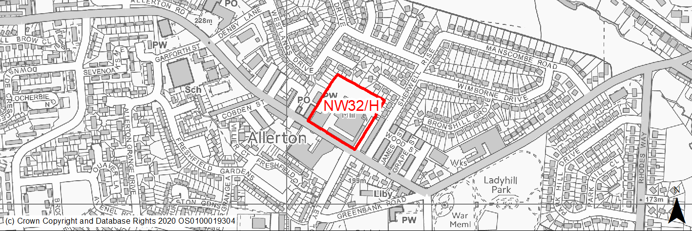
Site location
Regional City - Bradford NW
Ward
Thornton and Allerton
Site description
Underused mills and associated land.
Proposed Allocation
Housing
SHLAA referencce
NW/125
Indicative no. dwellings
200
Site area (Gross) (ha)
1.18
Ownership
Private
Delivery timescales
Developable (6-10 years)
Type (PDL/Greenfield)
PDL
Green Belt
No
Flood Zone
Flood Zone 1
Potential site access
Site can be accessed from Allerton Road but it will need amending to meet residential standards.
Public Transport Accessibility
Site within 400m of a High Frequency Bus Network
Sustainability Appraisal
See individual Sustainability Appraisal site comment in the accompanying report.
Habitats Regulations Assessment
This site falls within 7km of the South Pennine Moors SPA/SAC a HRA must be undertaken to ensure there are no significant effects on these protected sites in terms of recreational pressures. Developments within these zones must comply with Policy SP11; an SPD is being produced to provide further guidance.
Green Belt
N/A – Site not within the Green Belt.
Constraints and Opportunities
• An opportunity for a quality residential conversion that will secure the future of and conserve a significant heritage asset.
• Parts of the site are identified as being subject to surface water flood risk however draft SFRA concludes that there are no significant flood risk issues.
• Not within the S Pennine Moors SPA / SAC however within Zone C (within 7KM) which requires consideration of potential impacts relating to recreation pressures.
Development considerations
• A high quality scheme is required for very significant building. Listed structures must be retained and design and layout should ensure that any impacts on the listed building and its setting are avoided / mitigated.
• Development will need to consider how to mitigate any surface water flood risk issues.
Conclusion/Summary
The site lies in a sustainable location within Pool 1 (lowest flood risk and within the urban area) and subject to a sensitively designed scheme is considered suitable for residential development.
(2) NW33/H - Site of Anvil Court, Church Street, Manningham
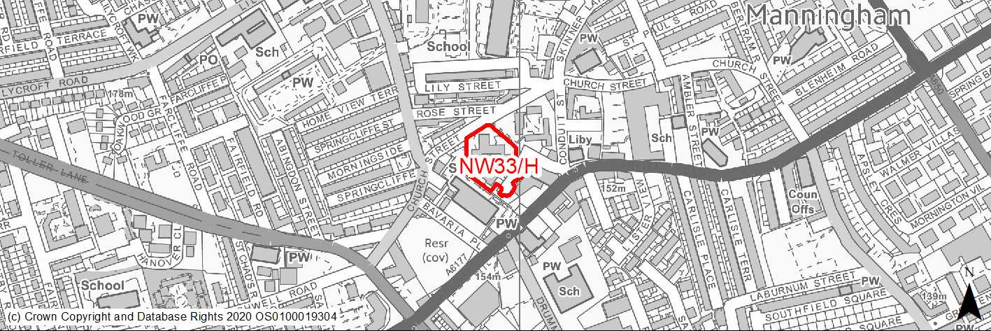
Site location
Regional City - Bradford NW
Ward
Manningham
Site description
Former site of residential flats. InCommunities proposed redevelopment to family homes.
Proposed Allocation
Housing
SHLAA referencce
NW/126
Indicative no. dwellings
30
Site area (Gross) (ha)
0.51
Ownership
In Communities
Delivery timescales
Deliverable (0-5 years)
Type (PDL/Greenfield)
PDL
Green Belt
No
Flood Zone
Flood Zone 1
Potential site access
Access is available from Carlisle Street.
Public Transport Accessibility
Site within 400m of a High Frequency Bus Network
Sustainability Appraisal
No significant adverse effects predicted for the site. Minor adverse effects predicted for air quality and water resources SA Objectives, as predicted for most sites. Development at the site would be a good opportunity to deliver biodiversity net gains, improvements to the local character and enhancements to the setting of nearby heritage assets. The site is well located to provide residents with good access to shops, jobs, buses, and cultural spaces, with particularly good access to schools and health facilities.
Habitats Regulations Assessment
This site is beyond the zones of influence of the South Pennine Moors SPA/SAC and is therefore unlikely to have any significant effects, a HRA is not required.
Green Belt
N/A – Site not within the Green Belt.
Constraints and Opportunities
• An opportunity to develop a cleared derelict site and contribute to the improvement and regeneration of the area.
• Northern half of site lies within 50M buffer of listed buildings at Church Street.
Development considerations
• Design and layout should ensure that any impacts on listed buildings are avoided / mitigated.
Conclusion/Summary
A brownfield site in a sustainable location within Pool 1 (lowest flood risk and within the urban area) where development could improve and regenerate the area. Suitable for residential development.
(2) NW34/H - Lister Mill & Surrounds
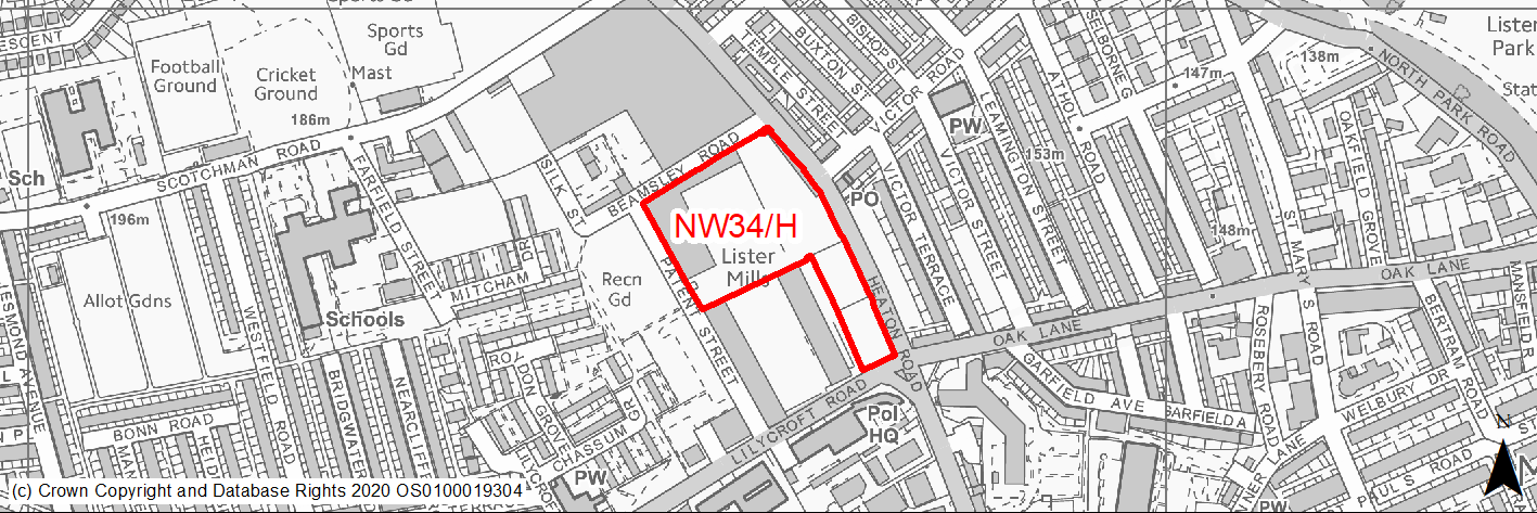
Site location
Regional City - Bradford NW
Ward
Toller
Site description
Vacant land surrounded by the former walls of the Velvet Mill at the Listers Mill complex
Proposed Allocation
Housing
SHLAA referencce
NW/129
Indicative no. dwellings
50
Site area (Gross) (ha)
1.86
Ownership
Private
Delivery timescales
Developable (6-10 years)
Type (PDL/Greenfield)
PDL
Green Belt
No
Flood Zone
Flood Zone 1
Potential site access
Access is available from Patent Street - though an adopted highway its condition is substandard and does not meet the Council's current requirements and would therefore need improvement.
Public Transport Accessibility
Site within 400m of a High Frequency Bus Network
Sustainability Appraisal
See individual Sustainability Appraisal site comment in the accompanying report.
Habitats Regulations Assessment
This site is beyond the zones of influence of the South Pennine Moors SPA/SAC and is therefore unlikely to have any significant effects, a HRA is not required.
Green Belt
N/A – Site not within the Green Belt.
Constraints and Opportunities
• An opportunity for a quality scheme which could contribute to the regeneration of the area and conserve and enhance remaining listed structures.
• Site lies within North Park Road Conservation Area, adjoins Grade 11 listed Lister Mill and contains several listed structures including the walls of the Velvet Mill.
• A very small area within the site is identified as having risk of surface water flooding.
• Site lies within the 150M and 250M buffer zone of former landfill to the N at the sports fields.
• Access is available from Patent Street - though an adopted highway its condition is substandard and does not meet the Council's current requirements and would therefore need improvement.
Development considerations
• Ideally the development should be progressed as part of a high quality comprehensive scheme which includes the adjoining listed structures and remaining vacant land around Lister Mill / Patent Street and enhances the area.
• Design and layout should ensure that any impacts on the Conservation Area and listed buildings are avoided / mitigated.
• Although Patent Street and Silk Street are both adopted highway their conditions are substandard and do not meet the Council's current requirements and would therefore need improvement.
• Surveys required to investigate and mitigate for any issues relating to landfill activities and surface water flood risk.
Conclusion/Summary
An important regeneration opportunity, a sustainable location within Pool 1 (lowest flood risk and within the urban area) where development could improve the area and conserve important listed structures.
(1) NW35/H - 29 Springfield Place
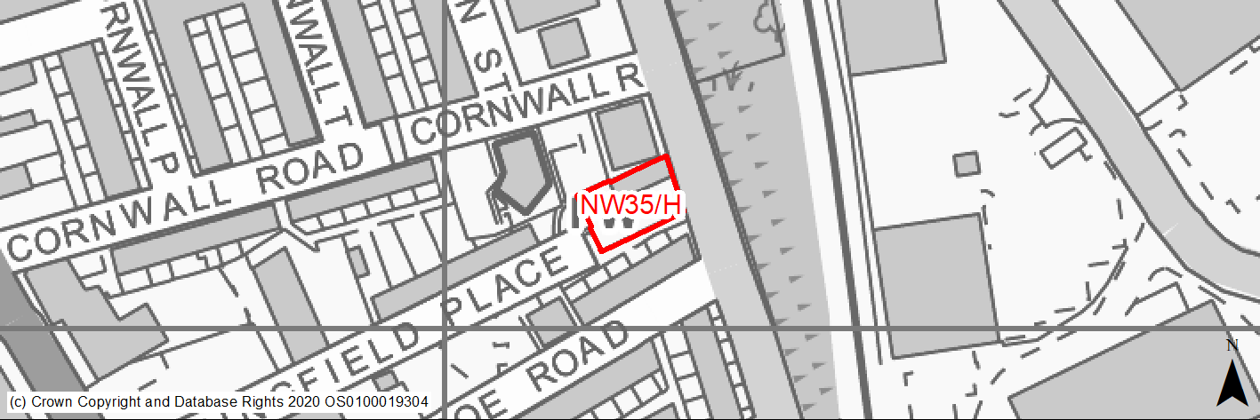
Site location
Regional City - Bradford NW
Ward
Manningham
Site description
Garage site, planning application decision pending on demolition and construction of 5 dwellings.
Proposed Allocation
Housing
SHLAA referencce
NW/130
Indicative no. dwellings
5
Site area (Gross) (ha)
0.07
Ownership
Private
Delivery timescales
Deliverable (0-5 years)
Type (PDL/Greenfield)
PDL
Green Belt
No
Flood Zone
Flood Zone 1
Potential site access
Access could be served from Midland Road.
Public Transport Accessibility
Site within 400m of a High Frequency Bus Network and within 800m of Forster Square Rail Station.
Sustainability Appraisal
The site could deliver major positive effects for residents on the health, transport and education SA Objectives as a result of being within the target distances for all necessary health facilities, bus stops and a rail link, and centres for primary and secondary education. A significant adverse effect has been predicted for the air quality SA Objective as a result of the site being situated entirely within the CAZ. Development here could potentially make achieving air quality improvement targets within the CAZ more difficult. Minor positive effects were predicted for most other socio-economic themed SA Objectives due to the benefits of new residential development for the local economy as well as the location of the site in relation to local services and amenities and employment areas.
As a PDL site containing buildings, new development here would provide an opportunity to achieve biodiversity net gains and improve the local townscape character, depending on the design and implementation of the development.
The only other adverse effect predicted for the site is minor and related to an increase in water consumption, which has been predicted at nearly all sites.
Habitats Regulations Assessment
This site is beyond the zones of influence of the South Pennine Moors SPA/SAC and is therefore unlikely to have any significant effects, a HRA is not required.
Green Belt
N/A – Site not within the Green Belt.
Constraints and Opportunities
• Site lies within draft Clean Air Zone.
• The SW corner of the site lies within the 250M buffer zone of a former landfill site at Midland Road.
• The southern and central parts of the site is identified as having 1/1000 year surface water flood risk.
Development considerations
• Development will need to consider how to mitigate any air quality and surface water flood risk issues.
• Surveys required to investigate and mitigate for any issues relating to former landfill activities.
Conclusion/Summary
The site, which previously has planning permission for 5 homes, lies in a sustainable location within the urban area and, subject to mitigation of flood risk and air quality issues is suitable for residential development.
(2) NW36/H - Heaton Mount
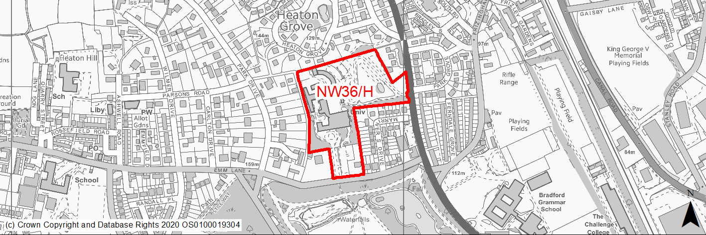
Site location
Regional City - Bradford NW
Ward
Heaton
Site description
Education Campus and conference venue comprising a variety of buildings some listed in an attractive landscaped setting.
Proposed Allocation
Housing
SHLAA referencce
NW/131
Indicative no. dwellings
195
Site area (Gross) (ha)
4.84
Ownership
Private
Delivery timescales
Developable (6-10 years)
Type (PDL/Greenfield)
Mixed
Green Belt
No
Flood Zone
Flood Zone 1
Potential site access
Access could be served from both Keighley Road and Emm Lane.
Public Transport Accessibility
Site adjoins a High Frequency Bus Network and is located within 800m of Frizinghall Rail Station.
Sustainability Appraisal
See individual Sustainability Appraisal site comment in the accompanying report.
Habitats Regulations Assessment
This site falls within 7km of the South Pennine Moors SPA/SAC a HRA must be undertaken to ensure there are no significant effects on these protected sites in terms of recreational pressures. Developments within these zones must comply with Policy SP11; an SPD is being produced to provide further guidance.
Green Belt
N/A – Site not within the Green Belt.
Constraints and Opportunities
• The site lies within Heaton Estates Conservation Area and contains several Grade II listed buildings including Heaton Mount.
• The site adjoins Lister Park which is a Class 2 W Yorkshire Archaeology site and a designated Historic Park & garden.
• The site lies within draft Clean Air Zone.
• The whole of the site is covered by a group TPO.
• The eastern section lies within a high risk area for former coal mining activity.
• The SW corner of the site lies within the 250M buffer zone of a former landfill site ref 13nw16 at Heaton Reservoir.
• There some small areas within the site subject to surface water flood risk.
• Priority Species - bat alert layer covers the site.
• Not within the S Pennine Moors SPA / SAC however within Zone C (within 7KM) which requires consideration of potential impacts relating to recreation pressures.
Development considerations
• This is a prime and attractive site which requires a high quality exemplar scheme.
• Design and layout should ensure that any impacts on the Conservation Area and listed buildings are avoided / mitigated.
• Development will need to consider how to mitigate any air quality and surface water flood risk issues.
• Development should where possible seek to retain protected trees and include additional new planting.
• Surveys required to investigate and mitigate for any issues relating to former coal mining and landfill activities.
Conclusion/Summary
An attractive site in a sustainable location within Pool 1 (lowest flood risk and within the urban area). Given sensitive design it is suitable for residential development and an opportunity for a high quality scheme.