
Draft Bradford District Local Plan - Preferred Options (Regulation 18) February 2021
Canal Road Corridor
Introduction
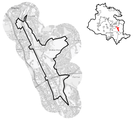
5.6.1 The Canal Road Corridor (CRC) is located within the main urban area of Bradford, stretching north from the city centre to Shipley alongside Canal Road. It is located within the Regional City of Bradford sub-area. The CRC forms part of the Shipley and Bradford East Parliamentary constituency and falls mainly within the Windhill and Wrose and Bolton and Undercliffe Wards.
5.6.2 The CRC is a traditional employment corridor as well as being a key, transport route northwards into and out of the city, forming a gateway into Airedale and beyond. Traditionally a mixed employment area, the CRC developed out of its close proximity to the Bradford Canal and the railway line. The CRC is today characterised by a range of uses. The central area around Bolton Woods has a variety of uses including existing residential communities and areas of employment, mainly located alongside Canal Road. To the south, the area has a predominance of retail, business and commercial uses, which link to Forster Square retail area.
5.6.3 The Corridor itself is relatively flat but is defined by a steep valley side to the East. The Bradford Beck watercourse flows south to north along the length of the Corridor, though for much of its length it is in culvert. The Shipley to Bradford Forster Square railway line defines the western edge of the area.
Figure 1: Location Plan
5.6.4 The area has a population of 3,089 and 61.2 % of the population falls within the working age category (16-64), similar to regional and national averages. The area has a higher proportion of people under 16 years and lower proportion over 65 years compared to the West Yorkshire and England averages. The ethnic composition consists of people who have identified themselves as White British (50.9%) and non-white (42.4%), which is a notably higher proportion than the West Yorkshire average, but is similar to other urban areas in the District.
5.6.5 The CRC is a regeneration priority area for the Council and was formerly identified as one of four Urban Eco Settlements in the City Region. A Joint Venture Company (JVCo) between the Council and Urbo Regeneration Ltd has been established to support the delivery of comprehensive regeneration in the Corridor. The Council's regeneration ambitions for the area include the delivery of the Canal Road Urban Village New Bolton Woods Masterplan Site - An 'asset based' Joint Venture Company between the Council and Urbo Regeneration Ltd, with the aim of delivering large scale regeneration within the designated Joint Venture Partnership Area. Initial phases of development of this site have been delivered over recent years, including new homes and supporting retail units.
Planning for Prosperity
5.6.7 The Local Plan settlement hierarchy identifies the CRC as within the Regional City of Bradford which is the prime focus for housing, employment, shopping, leisure, education, health and cultural activities and facilities in the District. There is a key focus on transforming its economic, environmental, physical and social conditions to support its long term regeneration. The CRC is also identified by the Local Enterprise Partnership as a Spatial Priory Area (SPA) Investment Location– an area where future housing and employment development should be encouraged.
5.6.8 The area provides the opportunity to deliver significant housing and economic growth supported by environmental and sustainable transport improvements and to secure direct investment and funding to support the delivery of innovative and sustainable development, climate change mitigation and green infrastructure enhancements.
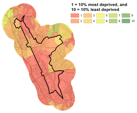
5.6.9 The CRC includes, and is bordered by, some of the most deprived areas within the District. This includes wards which are ranked amongst the 10% most deprived wards in England. The area is adjacent to Manningham Ward, which is ranked 1st of 30 wards in the District for the Index of Multiple Deprivation. Figure 2 shows the overall picture of deprivation in the CRC.
Figure 2: Index of Multiple Deprivation – Canal Road Corridor
Economy and Employment
5.6.10 The CRC has historically been, and remains, a corridor of industry and employment and includes areas that are home to a diverse range of established businesses and employers. The CRC currently provides significant employment opportunities and is popular with many business sectors. There are a range of local employment opportunities within the area. The largest employment sectors in terms of local workforce being retail (18%), health and social work (14%) and manufacturing (13%). Local businesses are generally centred around retail, professional, scientific and technical services, and business administration sectors. There are is one designated employment area within the CRC the Canal Road Employment Zone situated around Hillam Road and alongside Canal Road South of Queens Road. The area is also highly accessible to Bradford city centre and Shipley town centres to access a wider range of employment.
5.6.11 The economic activity rate at 64.9% is just below the West Yorkshire average (68.5%) as are the number of full-time, part-time and self-employed people. The average annual household income at £33,513 is below of the sub-regional average at £38,499.
5.6.12 No specific employment land allocation is proposed for this area, although under Policy SP6 economic growth and investment will continue to be supported particularly with a focus upon the priority sectors within the corridor of retail, manufacturing and professional services.
Retail
5.6.13 Within the Corridor there is a Neighbourhood Centre identified within the New Bolton Woods site. This includes an Aldi food-store and a frozen food store on land at Stanley Road as part of planning commitments for new convenience goods floor-space, within the neighbourhood centre at New Bolton Woods. Overall this Neighbourhood Centre is considered important in providing an appropriate neighbourhood scale centre to serve localised need to support significant future housing growth and existing communities within this sub area.
Transport and Access
5.6.14 The CRC is an important transport corridor, which provides a key link between Bradford city centre, Shipley and Airedale. The majority of the corridor is formed by the A6037 Canal Road/Valley Road. Canal Road is a strategic route within the wider Leeds City Region, linking areas within the Bradford District and beyond
5.6.15 Key transport issues for the Corridor include congestion and queuing during peak periods along Canal Road, in particular the Valley Road / Otley Road and Canal Road / Stanley Road junctions, and areas around Station Road and Bolton Lane. The £47m Bradford Shipley Route Improvement Scheme proposes a raft of measures to cut journey times, improve air quality, reduce road casualties and make the surrounding environments more ecologically friendly. The scheme is currently in development and includes sections of the A650 Manningham Lane and the A6037 Canal Road, Valley Road and A6038 Otley Road. Canal Road and Valley Road would become a streamlined high capacity route diverting non-local traffic from the A650. Junctions could be improved to increase traffic flow. Any new development in the CRC will need to be considered in terms of the road infrastructure along the Canal Road ensuring Canal Road maintains its function as a strategic transport corridor.
5.6.16 Canal Road/Valley Road is in part, not particularly well served by buses, with limited bus services along Canal Road itself. The CRC has good access to rail connections including Frizinghall, Shipley and Forster Square stations. The railway line and stations provide a key opportunity for providing sustainable transport options along the Corridor. However, existing stations along the Corridor at Frizinghall currently have limited parking and poor accessibility.
5.6.17 There are a number of public rights of way (PROW) footpaths which run along the CRC, including the long distance Dales Way link, which connects the area to the wider open countryside to the North. The CRC also benefits from the Canal Road Greenway, which is part of national cycle route 66 providing excellent opportunities for walking and cycling and a safe and attractive pedestrian and cycle route connecting Shipley and Bradford city centre. The route is also segregated from traffic where possible. Future developments will be expected to link to and contribute to enhancing and maintaining the quality of the Canal Road Greenway route and retain its attractiveness in terms of gradient and directness.
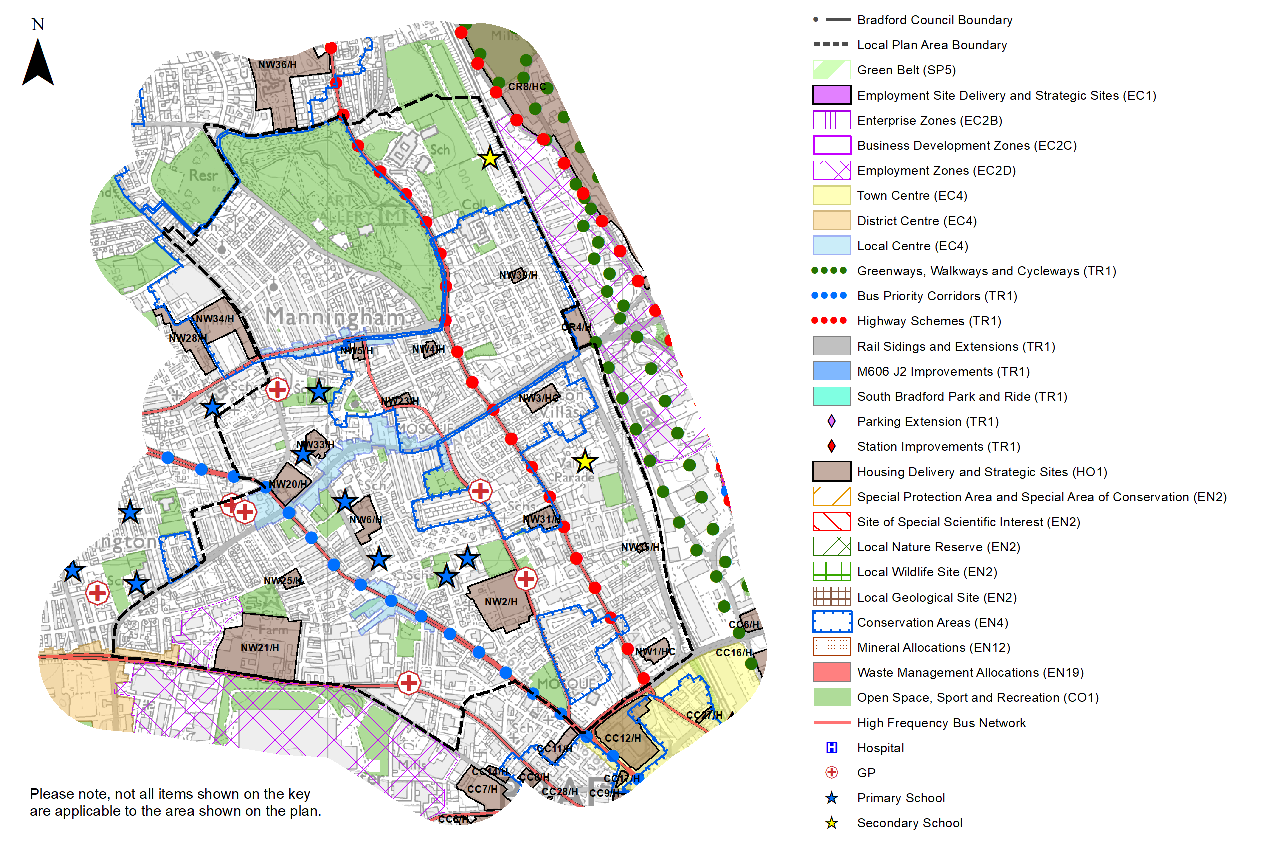
5.6.18 Strategic transport infrastructure projects to be delivered within the plan period and protected routes are set out on the Policies Map with the local plan. Key initiatives within the CRC are detailed in Table 1 below.
Table 1: CRC Transport Projects
|
Policies Map Ref. |
Project Name |
|
TR1.E.1 |
Bradford Shipley Route Improvement Scheme |
|
TR1.A.5 |
Canal Road Greenway (walking and cycling route) |
|
TR1.A.6 |
Bradford Canal |
|
TR1.B.2 |
Frizinghall Station improvements |
5.6.19 In relation to digital connectivity, average broadband download speeds is 39.47 megabites per second –faster than the West Yorkshire average (44.57), with 80 premises where speeds are below the Universal Service Obligation (USO).
Planning for Homes
5.6.20 There are 1,157 dwellings within the CRC area. A small proportion of these properties are owner occupied (38.6%), which is well below of the West Yorkshire average (63.4%). 34.8% are socially rented and 23.2% of properties are private rented, which are both higher than the regional and national averages.
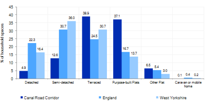
5.6.21 The CRC has a varied mix of house types ranging from older terraced properties, accounting for 38.9% and purpose built flats (37.1%) with fewer modern detached (4.9%) and semi-detached (12.6%) houses, which is well below the sub regional average. A large proportion of properties (28.7%) were built before 1900. Figure 3 below provides further information.
Figure 3: CRC – Dwelling Type Breakdown
5.6.22 Average house prices in the CRC are £135,719, which is lower than the than the West Yorkshire average of £183,194. The total affordability ratio between house prices and annual earnings which is usually used as a proxy for number of years' worth of earnings required for a house deposit is 2.31, compared to a West Yorkshire average of 2.96. Delivering new housing and sustainable neighbourhoods is a key part of the overall development strategy for the CRC. This includes major new housing development forming two new sustainable neighbourhoods focused on the New Bolton Woods and Bolton Woods Quarry sites. It will ensure that the housing needs and aspirations of local people can be met, together with those of future residents, including the provision of market and importantly affordable housing. further growth will support the council's regeneration ambitions for the CRC as a sustainable location for growth.
5.6.23 Policy SP8 in the local plan sets out a minimum requirement of 1,750 dwellings to be delivered in CRC during the plan period. These will be delivered through a mix of committed sites (those under construction or have planning permission but have not yet commenced) and allocations. Table 2 below sets out the housing position for CRC, which also includes the application of non-implementation or discount rates for planning permissions and allocations.
Table 2: Canal Road Corridor - Summary of Housing Requirement and Supply
|
Housing Target |
1,750 units |
|
Carried Forward Commitments* |
1,019 |
|
Commitment Discounted by 10% |
917 |
|
Remaining Allocation Requirement |
833 |
|
Identified Allocations |
927 |
|
Allocations Discounted by 10% |
834 |
|
Total Supply Contribution from Allocations |
834 |
*Includes New Bolton Woods which is partly under construction.
5.6.24 Once the commitments are discounted and removed from the supply this leaves a residual allocation requirement of 833 units. The evaluated total site supply of housing units from preferred allocation sites equates to 927 units which is in turn discounted by 10% for non- implementation or reduced delivery leaving a final allocation contribution of 834 units across all sites. The New Bolton Woods Site (CRC8/HC) has an approved hybrid planning application. This large site will be delivered in phases with initial phases already completed. It is therefore identified as a Housing Commitment (HC) site with remaining yield of 923 as future phases will require reserved matters to be approved. The Council will be supportive of additional proposals for new homes on additional small sites, particularly those that provide a redevelopment opportunity to bring forward land which has been previously used. Support will also be provided to developers who wish to redevelop larger sites and/or buildings for new homes not currently identified, subject to all relevant policies in the Local Plan.
5.6.25 The CRC is not constrained by Green Belt with brownfield and greenfield growth options available and identified. Seven further preferred option sites have been identified, comprised of four PDL and three greenfield sites. The Local Plan preferred site allocations for residential allocations to meet the CRC housing requirement are set out in Table A and identified on the Policies Map and the Site Proformas. Development of site allocations should be in accordance with specified development guidelines and approximate site provision figures and all other relevant policies of this Local Plan.
Planning for Places and Communities
Natural Landscape and Historic Character
5.6.26 Traditionally a mixed employment area, the Corridor developed out of its close proximity to the former Bradford Canal and the railway line. The CRC's heritage reflects that of a former industrial and employment area, set against the urban backdrop of the City of Bradford and the steep slopes surrounding Bolton Woods Quarry to the East of Canal Road, which give a more rural feel within the city. The CRC is focussed around Canal Road itself, which is a heavily trafficked highway.
5.6.27 The local area's defining natural and man-made landscape features are the flat linear form of the corridor alongside the Bradford Beck and adjacent green space and steep valley sides to the East of the Corridor around Bolton Woods Quarry. The area includes and is adjacent to a number of important heritage assets, including a number of Conservation Areas, historic parks and listed buildings. Within the CRC there are 5 statutory Listed Buildings. The settlement has no conservation area.
5.6.28 The former Bradford Canal previously ran for 3 miles through the CRC from the Leeds and Liverpool Canal at Shipley to the centre of Bradford. The Bradford Canal closed to navigation in 1922, but re-introduction of the Bradford Canal has been a long term ambition for the Council. The reopening of the Bradford canal is not considered economically feasible over the short to medium term, however, the plan includes provision to safeguard an alignment for proposed re-introduction of the Bradford Canal to enable its future provision.
Green Infrastructure, Ecology, Open Space and Flood Risk
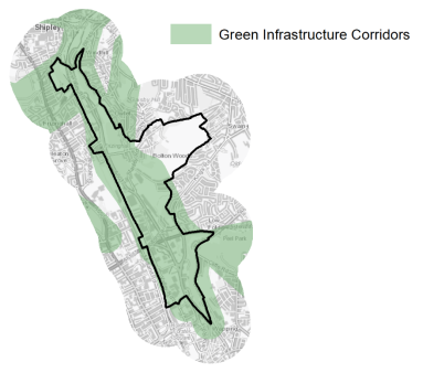
5.6.29 The CRC is a key Green Infrastructure Corridor for the District and has a range of areas and spaces that contribute towards its Green and Blue Infrastructure. The Bradford Beck forms an important blue/green corridor and habitat highway running through the heart of the CRC. Other key Green and blue corridors, include the green corridor along Bolton Road to the south of the area, the greenspaces and recreation areas adjacent Canal Road including Gaisby Lane & King George Playing Fields. This is a linear flat area of open land running parallel to Bradford Beck, used for formal and informal recreation and playing fields. Also Brow Wood Crescent and Poplars Farm include areas of open land, which form part of an open space corridor.
5.6.30 The Council to undertook a Green Infrastructure (GI) Study to assess the existing and future potential of green infrastructure within the CRC. The GI Study (2014) puts forward a number of key Green Infrastructure interventions. These focus around the theme of ''The Linear Park' running from Bradford city centre to Shipley and cover interventions including re- naturalising the Bradford Beck, habitat highways, new parks and greenspaces and the Canal Road Greenway. The main GI corridors are detailed below in Figure 4.
Figure 4: Green Infrastructure Corridors
5.6.31 The area contains an Urban Wildlife Reserve at Boars Well and Poplars Farm (Bradford Wildlife Area) plus a wide range of ecologically important habitatsnetworks. The Ecological Study (2014) for the CRC area identified a number of key interventions including Canal Road (The Nectar Highway), the railway network including Frizinghall station and railway margins (The Butterfly Express) the Canal Road Greenway (The Greener Way) and Bolton Woods Quarry and Bolton Woods ecological corridor, including Boars Well (The Green Lungs of Bradford).
5.6.32 In regards to formal open space, the area currently benefits from large areas of public open space and playing fields running through the heart of the area, which provide recreational opportunities within the Corridor. This includes a number of sports and leisure facilities including Bolton Woods Junior Football Club and the King George V Playing Fields off Canal Road. The CRC has former of allotments which have been found to lie on contaminated ground and are no longer in active use. The CRC's location means that parts of area along the valley floor are at risk of river flooding from the Bradford Beck. There are areas of higher flood risk alongside the Bradford Beck in particular around the centre and northern parts of the CRC.
5.6.32 There are 41 sites identified as open space covering an area of around 58ha. The key sites within the CRC are:
- King George V Memorial Playing Fields
- Bradford Beck
- Red Beck Allotments
- Queens Road Allotments
- Bolton Hall Woodland.
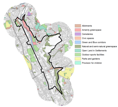
5.6.33 Whilst the CRC has a positive amount of open space, there are some imbalance between the different typologies of open space that currently exist. Of particular note is the deficit of Parks and Gardens open space in this area, although there are other types of open space such as Amenity Greenspace and Outdoor Space which play a similar role and in part provides compensatory provision. Future opportunities to rebalance the different open space sites could see some of these spaces be developed into formal park space. Figure 5 illustrates the current open space provision in and on the edge of the area.
Figure 5: CRC - Open Space Overview
Community Infrastructure – Education, Health and Utilities
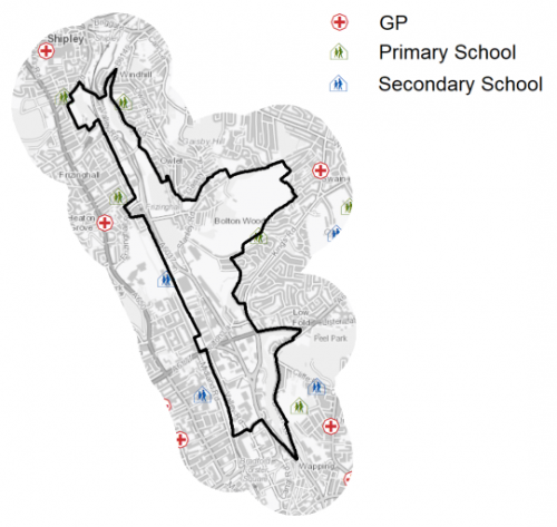
5.6.34 The CRC has limited community facilities to meet the day to day needs of local people due to the relatively small population in the area. These include a playground, local shops and various sporting facilities. The CRC is served by 1 primary school (Poplars Farm Primary School) and the closest secondary is in Manningham (Bradford Grammar and Oasis Academy Lister Park). Pupils attainment at key stage 1, 2 and 4 for average points is lower than both the national (England) and West Yorkshire averages.
5.6.35 There are no NHS registered healthcare facilities within the CRC. Secondary (acute) healthcare is provided at Bradford Royal Infirmary, around 2km to the West. Average life expectancy for CRC residents is 76 years for men and 80 years for women, which is below the West Yorkshire and England averages. Healthy life expectancy is 57 years for men and 56 years for women, which well below West Yorkshire and England averages. Figure 6 illustrates the location of schools and medical facilities which lie close to the boundary of the CRC area.
Figure 6: Schools & Medical Facilities in the CRC
5.6.36 When planning for the long-term development of Bradford North East, it is vital that new development is supported by the appropriate infrastructure. The capacity, quality and accessibility of services and facilities are all key components in ensuring people can enjoy living, working and visiting the area. The Council will continue work with key infrastructure providers and others including the Local Education Authority, Clinical Commissioning Group and utilities providers to determine the impacts of future growth and development on local infrastructure capacity and provision. Further infrastructure details will be published through the Local Infrastructure Plan and as part of the Regulation 19 stage of the local plan.
5.6.37 There is one former waste management facility located within in the area, the former Associated Waste Management site north of Frizinghall station. The. Associated Waste Management site was a materials recovery facility (MRF) within a central urban area, with good access to the Primary Road Network. The site was a very important component of Bradford's waste management infrastructure until recently. Further consideration is currently being taken to determine an appropriate use for this site which may be affected by proposed road improvements in the area.
5.6.38 Within the District there are certain sites and pipelines, designated by the Health and Safety Executive (HSE) as hazardous installations because of the quantities of hazardous substances stored, used or transmitted. Within the are there is one hazardous installation (Transco PLC, Canal Road Holder Station) and a high pressure gas pipeline (Northern Gas Networks, Canal Road/Hartshead) around which the HSE have identified consultation zones.
|
Local Area Strategy and Plan – Canal Road Corridor |
|
|
The key elements of the local area strategy for the Canal Road Corridor include:
• Maintaining the area as a key location for investment and regeneration. The CRC will see the delivery of 1,750 new homes on a mixed portfolio of sites which will be supported by new business, retail, leisure and community facilities. • The development of a series of vibrant new sustainable neighbourhoods that provide a range of high quality homes of different sizes and types and specialist housing products, including housing for older people and custom build/self build plots • New supporting infrastructure necessary to meet local needs and the creation of sustainable neighbourhoods with a new centre which will provide a focus for new and existing communities and provide local shops, community and leisure facilities, alongside new business and employment uses. • Improved access for residents to open space including the Linear Park, revitalised Bradford Beck and Canal Road Greenway running from Bradford city centre to Shipley. This multi-functional green corridor will help enhance biodiversity and ecological networks and provide a high quality setting for walking, cycling, sport and recreation along the Corridor. • Safeguarding and enhancing the Canal Road Employment Zone as an important local employment area. • Supporting the delivery of major transport improvements and infrastructure required to accommodate the growth, including the Bradford Shipley Route Improvement Scheme • Protecting an alignment for the Shipley Eastern Relief Road. Development proposals which impact the route of the Shipley Eastern Relief Road will be expected to protect an alignment, which enables the future implementation of the scheme • Maximising Sustainable Transport including working with partners to support the delivery of improvements to Frizinghall station as a key public transport facility, including vehicular, pedestrian and cycle access and parking facilities, and improved pedestrian and cycle links from development sites. • Supporting improved bus services along Canal Road and new connections to large scale housing sites. • Supporting improved pedestrian and cycle movements through and across the Corridor. Identifying the Canal Road Greenway as a strategic cycle and walking route. Development of sites on or adjacent the Greenway will be expected to maintain the route of the Greenway in terms of its attractiveness and gradient and integrate the Greenway as key part of the site design • Protecting an alignment for proposed re-introduction of the Bradford Canal to enable its future provision. Development proposals impacting the proposed route will be expected to accommodate future ambitions to reinstate the Bradford Canal. Proposals should seek to integrate the route as a key part of the site's design. The route of the proposed Bradford Canal is shown on the Policies Map • Ensuring all development proposals protect and enhance key green infrastructure and ecological networks directly related to the site. Major developments will be expected to demonstrate that they will positively contribute to enhancing identified site specific green infrastructure and ecological networks, and include green infrastructure as an integral part of the design. • Supporting the delivery of Green Infrastructure enhancement projects. This includes the creation of a new Linear Park, alongside the Bradford Beck and Canal Road Greenway to serve and integrate new and existing communities along the Corridor. • Identifying the Bradford Beck as a key waterway and green infrastructure asset. The council will support the delivery of projects to enhance the environmental quality of the Bradford Beck, including the re-naturalisation of the Beck. This will include maintaining and providing site specific pedestrian and cycle links to and alongside the Beck. • Protecting and enhancing locally designated wildlife sites in the Corridor: • Within the New Bolton Woods and Bolton Woods Quarry sites any loss of land formerly used as recreation open space will be mitigated through the provision of new and enhanced areas of open space |
To |
(4) Consultation Question 94
Canal Road Corridor Local Area Strategy
The Local Plan sets out a local area strategy for the Canal Road Corridor.
Q. Please provide any comments you may have on the area strategy?
If you have an alternative to the approaches undertaken, please provide further details and evidence in support.
Preferred Site Allocations and Site Pro Formas
5.6.39 The preferred housing site allocations are detailed below in Table A. This table is subsequently followed by site pro formas for each preferred site allocation proving a summary of key site information and characteristics.
|
Site Ref |
Site Name |
Dwellings |
|
CR1/H |
Bolton Road |
16 |
|
CR2/H |
Bolton Woods Quarry |
762 |
|
CR3/H |
Wapping Road, Bolton Road |
23 |
|
CR4/H |
North Avenue, Manningham |
30 |
|
CR5/H |
Frizinghall Rd |
42 |
|
CR6/H |
North Bolton Hall Road |
35 |
|
CR7/H |
Thornhill Avenue |
19 |
|
CR8/HC |
New Bolton Woods (included as part of the commitments - with both detailed and outline permissions in place) |
(923) |
|
Total |
927 |
Table A: Canal Road Corridor: Housing - Preferred Allocations
(1) Consultation Question 95
Canal Road Corridor: Site Allocations and Site Pro Formas
The Local Plan sets out a series of preferred site allocations. If you wish to make representations on any of the sites proposed, please provide site reference and feedback under this question.
If you wish to propose an additional or alternative site(s) to the preferred allocations listed, please also provide a plan with a red line and any further details in support.
(2) CR1/H - Bolton Road
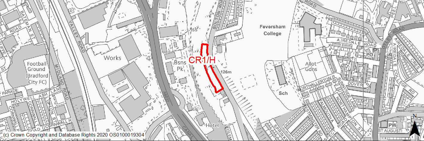
Site location
Regional City - Canal Road Corridor
Ward
Bolton and Undercliffe
Site description
Grassy bank sloping to the west containing some trees.
Proposed Allocation
Housing
SHLAA referencce
CR/004
Indicative no. dwellings
16
Site area (Gross) (ha)
0.31
Ownership
Private
Delivery timescales
Developable 6-11 years
Type (PDL/Greenfield)
Greenfield
Green Belt
No
Flood Zone
Flood Zone 1
Potential site access
This is a narrow strip of land with a steep drop at the rear and it is unlikely that an internal access road could be created. Notwithstanding this, Bolton Road is relatively wide at this location and on-street parking or drives may be acceptable.
Public Transport Accessibility
Site within 400m of a bus stop and beyond 800m of nearest rail station (Frizinghall).
Sustainability Appraisal
Site has been subject to a recent Sustainability Appraisal (SA) as part of the Area Action Plan process, for additional appraisal commentary please see the site reference within the Sustainability Appraisal accompanying the Local Plan.
Habitats Regulations Assessment
This site is beyond the zones of influence of the South Pennine Moors SPA/SAC and is therefore unlikely to have any significant effects, a HRA is not required.
Green Belt
N/A – Site not within the Green Belt.
Constraints and Opportunities
• The site is suitable for medium/high density residential development.
Development considerations
• Development will be expected to protect the ecological corridor and Bradford Wildlife Area to the west of the site and link to the Green Corridor to the north.
Conclusion/Summary
The site was previously allocated for residential use in the SCRC AAP (CCF2). This is a sustainably located mixed site within the settlement boundary which will deliver approximately 16 residential units.
(2) CR2/H - Bolton Woods Quarry
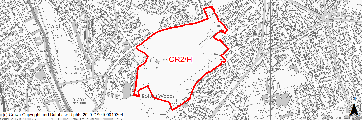
Site location
Regional City - Canal Road Corridor
Ward
Windhall and Wrose
Site description
The site is located in the heart of the Corridor and occupies a strategic position above the New Bolton Woods site. The site comprises a large area of land currently in use as an existing working quarry. The site is previously developed land of strategic size and scale.
Proposed Allocation
Housing
SHLAA referencce
CR/014
Indicative no. dwellings
762
Site area (Gross) (ha)
29.79
Ownership
Private
Delivery timescales
Developable 6-15 years
Type (PDL/Greenfield)
PDL
Green Belt
No
Flood Zone
Flood Zone 1
Potential site access
A number of access points may be required to minimise impact on the strategic highway corridor along Canal Road. Appropriate access would be considered from Bolton Hall Road and Livingstone Road to the north and through the adjacent New Bolton Woods site to the south.
Public Transport Accessibility
Site within 400m of a bus stop and beyond 800m of nearest rail station (Frizinghall).
Sustainability Appraisal
Site has been subject to a recent Sustainability Appraisal (SA) as part of the Area Action Plan process, for additional appraisal commentary please see the site reference within the Sustainability Appraisal accompanying the Local Plan.
Habitats Regulations Assessment
This site falls within 7km of the South Pennine Moors SPA/SAC a HRA must be undertaken to ensure there are no significant effects on these protected sites in terms of recreational pressures. Developments within these zones must comply with Policy SP11; an SPD is being produced to provide further guidance.
Green Belt
N/A – Site not within the Green Belt.
Constraints and Opportunities
• The comprehensive redevelopment of the quarry presents a key opportunity for delivering significant level of housing development and environmental improvements in the heart of the Corridor.
• The site is identified as a key opportunity to enhance green infrastructure and ecological assets and provide new green space within the development.
• Part of the site intersects the National Grid Electricity Transmission.
Development considerations
• The landowners should work with the council, key stakeholders, and the community to bring forward a scheme which will deliver comprehensive regeneration and identified infrastructure for the site as a whole. Supporting community facilities and small shops units will be supported to meet local day-to-day needs, in accordance with strategic retail Local Plan policy.
• Proposals will be expected to contribute to appropriate and proportionate improvements to existing education provision or new provision Development will be expected to: Provide significant improvements to green infrastructure including the creation of new on-site open space, play areas and wildlife areas, which link to proposals developed as part of New Bolton Woods.
• Protect and enhance the Wildlife Habitat Network in the immediate surrounds of the quarry and contribute to habitat creation as part of the quarry restoration. This should include the creation of heath land habitat/acidic grassland in line with the Ecological Assessment, where feasible. Proposals should be supported by a Green Infrastructure Strategy Development will be expected to: Provide new high quality on site open space and play areas. Due to the size and significance of the site a Masterplan/Development Brief should be prepared to ensure that the site is developed in a comprehensive manner and that future phases relate well to each other. Proposals should be submitted for independent design review at an early stage. Proposals will be expected to: Integrate with new and existing communities and provide safe and attractive links to New Bolton Woods, surrounding communities and significant areas of green space.
• Demonstrate how the scheme connects to surrounding communities and relates to future development at New Bolton Woods (NBW1). Development should ensure elements which contribute to the character or setting of Grade II* Listed Bolton Old Hall and Bolton Old Hall Cottage are preserved. Any new development should seek to avoid harm to the significance of these heritage assets and take opportunities within their setting to enhance or better reveal their significance. Any scheme will be expected to include a well-designed and managed open landscaped setting that positively responds to the listed buildings, and provides effective separation between any new development and these heritage assets. In order to safeguard the setting of the Grade II* listed buildings Bolton Old Hall and Bolton Old Hall Cottage, an area of land to the immediate south-west of these buildings and northwest between Cheltenham Road and Brookwater Drive, should be kept free from any from any new residential development, roads or other buildings. The extent of these areas shall be determined by a detailed and comprehensive analysis in the form of a Heritage Impact Assessment, to be submitted in support of any planning application for development of the site. The Heritage Impact Assessment shall evaluate the contribution made by the setting of the identified heritage assets, including important views and other attributes that are important to the significance of the properties and their protection, and provide an open and landscaped setting that is required to sustain and enhance the significance of these assets.
Transport and Movement:
• Any development proposals should be accompanied by a Transport Assessment detailing access and service arrangements and connectivity to the wider highway network including local primary roads and the strategic road network.
• A number of access points may be required to minimise impact on the strategic highway corridor along Canal Road. Appropriate access would be considered from Bolton Hall Road and Livingstone Road to the north and through the adjacent New Bolton Woods site to the south.
• The development should take account of the adjacent New Bolton Woods Masterplan proposals.
Minerals:
• Any proposals for the redevelopment of the site should provide for the prior extraction of any remaining high quality stone reserves, and demonstrate it would not be affected by any unacceptable land stability risks.
• Proposals should provide for environmental remediation of the quarry site. A low-level quarry restoration scheme is due to be submitted for approval by September 2017. Although the quarry restoration would not cover the potential residential end use, consideration should be given to how the quarry restoration scheme could optimise the potential of the site to facilitate a comprehensive development scheme for the site and should consider the potential engineering requirements associated with accommodating built development. It should be noted that any substantial engineering operations associated with preparing the quarry site for future development could not be covered under an outline planning application.
• Development proposals will need to consider the potential presence of unstable land and any planning applications are expected to be accompanied by a Mining Risk Assessment.
Conclusion/Summary
The site was previously allocated for residential use in the SCRC AAP (BWQ1). This is a sustainably located brownfield site within the settlement boundary which will deliver approximately 762 residential units.
(2) CR3/H - Wapping Road, Bolton Road
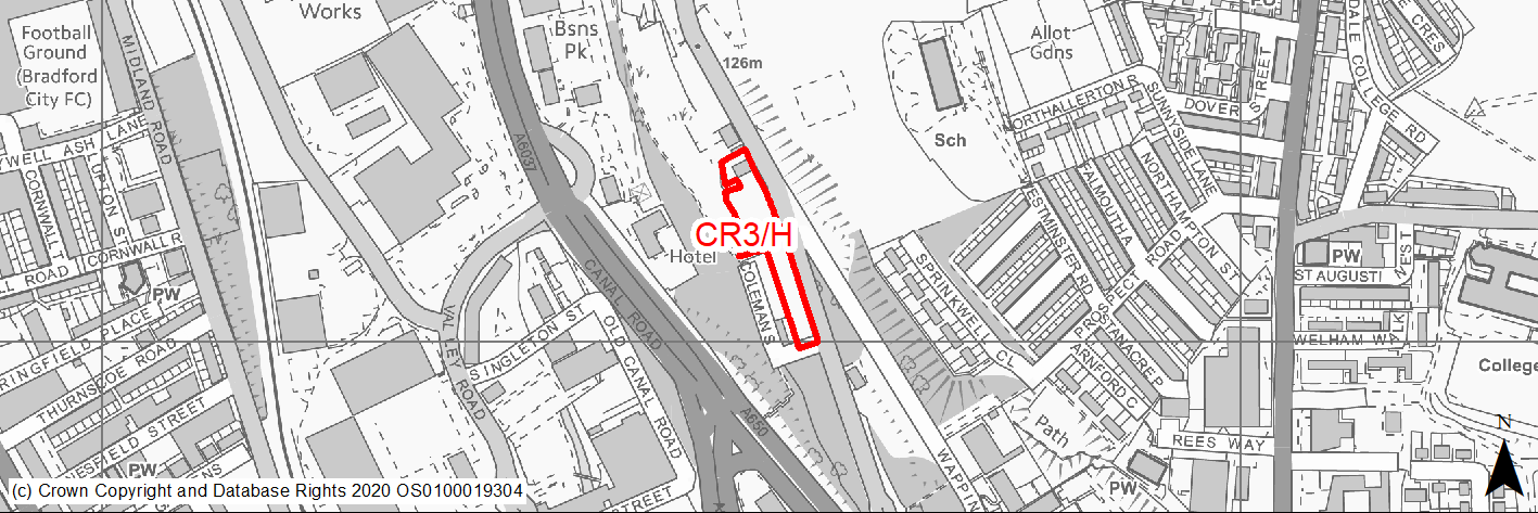
Site location
Regional City - Canal Road Corridor
Ward
Bolton and Undercliffe
Site description
The site includes the vacant public house and level grassed area steeply sloping to the west.
Proposed Allocation
Housing
SHLAA referencce
CR/017
Indicative no. dwellings
23
Site area (Gross) (ha)
0.46
Ownership
Private
Delivery timescales
Developable 6-15 years
Type (PDL/Greenfield)
Greenfield
Green Belt
No
Flood Zone
Flood Zone 1
Potential site access
If an internal access road for parking and servicing can be created then development would be acceptable in highway terms from Bolton road access sited away from the Wapping Road junction. Any direct access to individual dwellings from Bolton Road at this location would be unacceptable in highway terms.
Public Transport Accessibility
Site within 400m of a bus stop and beyond 800m of nearest rail station (Frizinghall).
Sustainability Appraisal
Site has been subject to a recent Sustainability Appraisal (SA) as part of the Area Action Plan process, for additional appraisal commentary please see the site reference within the Sustainability Appraisal accompanying the Local Plan.
Habitats Regulations Assessment
This site is beyond the zones of influence of the South Pennine Moors SPA/SAC and is therefore unlikely to have any significant effects, a HRA is not required.
Green Belt
N/A – Site not within the Green Belt.
Constraints and Opportunities
• The site is suitable for medium/ high density residential development.
• The site may be more suitable for an apartment block located to the north close to the Wapping Road junction and a car park sited to the southern end.
Development considerations
• Development will be expected protect the ecological corridor and Bradford Wildlife Area to the west of the site.
Conclusion/Summary
The site was previously allocated for residential use in the SCRC AAP (CCF3). This is a sustainably located site within the settlement boundary which will deliver approximately 23 residential units.
(2) CR4/H - North Queens Road
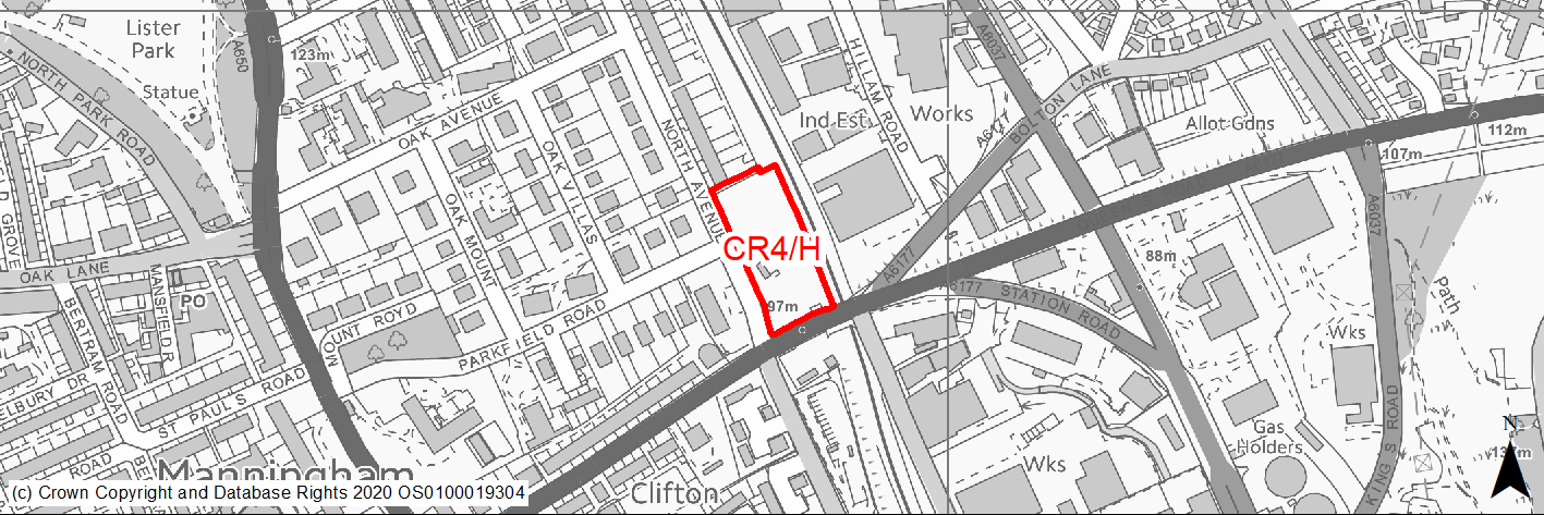
Site location
Regional City - Canal Road Corridor
Ward
Manningham Road
Site description
The site is partly in use as a reclamation yard.
Proposed Allocation
Housing
SHLAA referencce
CR/033
Indicative no. dwellings
30
Site area (Gross) (ha)
0.8
Ownership
Private
Delivery timescales
Developable 6-15 years
Type (PDL/Greenfield)
PDL
Green Belt
No
Flood Zone
Flood Zone 1
Potential site access
The existing site access may lead to conflicts particularly with right turning traffic manoeuvres at Midland Road and Valley Road junctions. Access off North Avenue would be preferred though this is unlikely to be practical due to the level difference between the highway and the site. If the existing site access is to be used then this would need to be brought up to adoptable standards as a traditional estate road.
Public Transport Accessibility
Site within 400m of a bus stop and beyond 800m of nearest rail station (Frizinghall).
Sustainability Appraisal
Site has been subject to a recent Sustainability Appraisal (SA) as part of the Area Action Plan process, for additional appraisal commentary please see the site reference within the Sustainability Appraisal accompanying the Local Plan.
Habitats Regulations Assessment
This site is beyond the zones of influence of the South Pennine Moors SPA/SAC and is therefore unlikely to have any significant effects, a HRA is not required.
Green Belt
N/A – Site not within the Green Belt.
Constraints and Opportunities
• Site adjacent St Paul Conservation area.
Development considerations
• Development should safeguard and where possible, enhance the St Paul Conservation area.
• Mitigation of surface water flood risk/drainage issues.
Conclusion/Summary
The site was previously allocated for residential use in the SCRC AAP (NBW6). This is a sustainably located site within the settlement boundary which will deliver approximately 30 residential units.
(2) CR5/H - Frizinghall Road
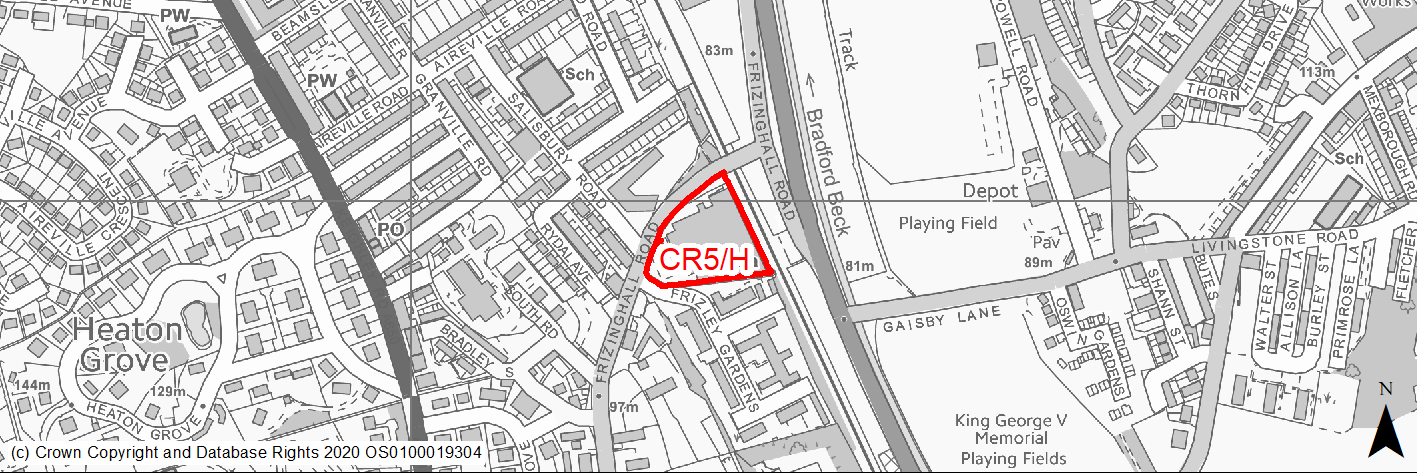
Site location
Regional City - Canal Road Corridor
Ward
Heaton Ward
Site description
Currently occupied by an industrial building and associated hardstanding in the form of car park and access road. There are a number of trees located along the boundaries of the site.
Proposed Allocation
Housing
SHLAA referencce
CR/034
Indicative no. dwellings
42
Site area (Gross) (ha)
0.76
Ownership
Private
Delivery timescales
Developable 6-15 years
Type (PDL/Greenfield)
PDL
Green Belt
No
Flood Zone
Flood Zone 1
Potential site access
The site is accessed from the existing access off Frizinghall Road, which will require improvement.
Public Transport Accessibility
Site within 400m of a bus stop and 800m of nearest rail station (Frizinghall).
Sustainability Appraisal
Site has been subject to a recent Sustainability Appraisal (SA) as part of the Area Action Plan process, for additional appraisal commentary please see the site reference within the Sustainability Appraisal accompanying the Local Plan.
Habitats Regulations Assessment
This site falls within 7km of the South Pennine Moors SPA/SAC a HRA must be undertaken to ensure there are no significant effects on these protected sites in terms of recreational pressures. Developments within these zones must comply with Policy SP11; an SPD is being produced to provide further guidance.
Green Belt
N/A – Site not within the Green Belt.
Constraints and Opportunities
• The site is suitable for medium density residential development.
• There are a number of trees located along the boundaries of the site.
Development considerations
• Development should respond positively to the site’s characteristics including its frontages to the railway, Frizinghall Road and the junction with Frizley Gardens, and the footpath along the southern boundary.
• TROs may be required on Frizinghall Road to prevent on-street parking and protect visibility splays.
Conclusion/Summary
The site was previously allocated for residential use in the SCRC AAP (NBW2). This is a sustainably located brownfield site within the settlement boundary which will deliver approximately 42 residential units. The site is located adjacent to Frizinghall rail station and therefore the development would be required to
minimise traffic generation. Development proposals should be accompanied by a Transport Statement detailing access and service arrangements and connectivity to the wider highway network.
(2) CR6/H - North Bolton Hall Road
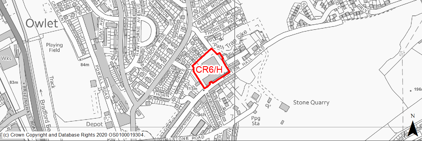
Site location
Regional City - Canal Road Corridor
Ward
Windhall and Wrose
Site description
Disused warehouse with adjoining mill and industrial buildings with previous outline permission for residential development.
Proposed Allocation
Housing
SHLAA referencce
CR/036
Indicative no. dwellings
35
Site area (Gross) (ha)
0.84
Ownership
Private
Delivery timescales
Developable 6-15 years
Type (PDL/Greenfield)
PDL
Green Belt
No
Flood Zone
Flood Zone 1
Potential site access
An acceptable site access could be provided from Bolton Hall Road subject to provision of appropriate visibility splays and on-site turning area to accommodate refuse vehicles.
Public Transport Accessibility
Site beyond 400m of a bus stop andwithin 800m of nearest rail station (Frizinghall).
Sustainability Appraisal
Site has been subject to a recent Sustainability Appraisal (SA) as part of the Area Action Plan process, for additional appraisal commentary please see the site reference within the Sustainability Appraisal accompanying the Local Plan.
Habitats Regulations Assessment
This site falls within 7km of the South Pennine Moors SPA/SAC a HRA must be undertaken to ensure there are no significant effects on these protected sites in terms of recreational pressures. Developments within these zones must comply with Policy SP11; an SPD is being produced to provide further guidance.
Green Belt
N/A – Site not within the Green Belt.
Constraints and Opportunities
• The site is suitable for medium density residential development.
• Part of site former landfill.
Development considerations
• The potential for conversion of existing mill buildings should be considered.
Conclusion/Summary
The site was previously allocated for residential use in the SCRC AAP (NBW4). This is a sustainably located brownfield site within the settlement boundary which will deliver approximately 35 residential units.
(1) CR7/H - Thornhill Avenue
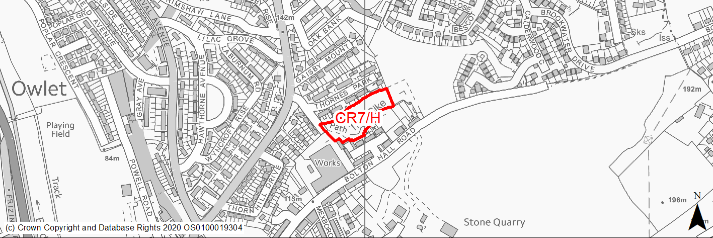
Site location
Regional City - Canal Road Corridor
Ward
Windhall and Wrose
Site description
Sloping greenfield site with mature trees surrounded by industrial and residential development.
Proposed Allocation
Housing
SHLAA referencce
CR/037
Indicative no. dwellings
19
Site area (Gross) (ha)
0.6
Ownership
Private
Delivery timescales
Developable 6-15 years
Type (PDL/Greenfield)
Greenfield
Green Belt
No
Flood Zone
Flood Zone 1
Potential site access
The site is accessed from Thornhill Avenue which currently terminates in a cul-de-sac whereby access to the site is gained via a public right of way linking up to St Laurence’s Close to the south. In order to maintain the width of the highway, the development would need to make provision for relocation of on-street parking for residents of Thornhill Avenue and thereby maintain access to all dwellings in this location.
Public Transport Accessibility
Site beyond 400m of a bus stop andwithin 800m of nearest rail station (Frizinghall).
Sustainability Appraisal
Site has been subject to a recent Sustainability Appraisal (SA) as part of the Area Action Plan process, for additional appraisal commentary please see the site reference within the Sustainability Appraisal accompanying the Local Plan.
Habitats Regulations Assessment
This site falls within 7km of the South Pennine Moors SPA/SAC a HRA must be undertaken to ensure there are no significant effects on these protected sites in terms of recreational pressures. Developments within these zones must comply with Policy SP11; an SPD is being produced to provide further guidance.
Green Belt
N/A – Site not within the Green Belt.
Constraints and Opportunities
• Surface water flood risk.
• The site is suitable for medium density residential development.
• Existing mature trees and TPO woodland within site.
• Site within Landfill 150m buffer.
Development considerations
• Mitigation of surface water flood risk/drainage issues.
• Development should retain the pedestrian link between Thornhill Avenue and St Laurence’s Close.
• Development should protect existing TPO trees.
Conclusion/Summary
The site was previously allocated for residential use in the SCRC AAP (NBW3). This is a sustainably located greenfield site within the settlement boundary which will deliver approximately 19 residential units.
(3) CR8/HC - New Bolton Woods
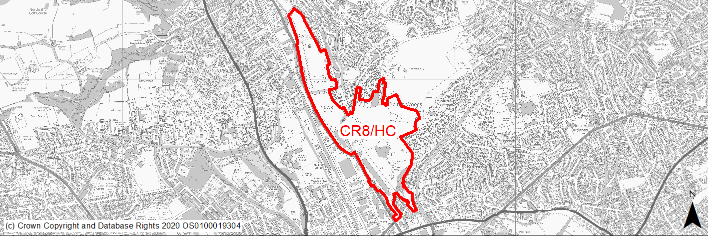
Site location
Regional City - Canal Road Corridor
Ward
Bolton and Undercliffe/Windhall and Wrose
Site description
The site covers a large area of land, which forms part of designated Joint Venture Partnership Area. The site includes existing areas of open space, playing fields, employment land and the Bradford Beck running alongside Canal Road. In addition there are large areas of open space and woodland on hillsides around Poplars Park Road.
Proposed Allocation
Mixed Use
SHLAA referencce
CR/011/CR019
Indicative no. dwellings
923
Site area (Gross) (ha)
49.28
Ownership
Joint Venture Company
Delivery timescales
Deliverable and developable 0-18 years
Type (PDL/Greenfield)
Mixed
Green Belt
No
Flood Zone
Flood Zone 1, part of northern site Flood Zone 2 and Flood Zone 3a along Bradford Beck
Potential site access
Access to the site is available from multiple access points from the surrounding road network (Poplars Park Road, Stanley Road, Gaisby Lane, Poplar Road).
Public Transport Accessibility
Site within 400m of a bus stop and 800m of a rail station (Frizinghall).
Sustainability Appraisal
Site has been subject to a recent Sustainability Appraisal (SA) as part of the Area Action Plan process, for additional appraisal commentary please see the site reference within the Sustainability Appraisal accompanying the Local Plan.
Habitats Regulations Assessment
Part of this site falls within 7km of the South Pennine Moors SPA/SAC a HRA must be undertaken to ensure there are no significant effects on these protected sites in terms of recreational pressures. Developments within these zones must comply with Policy SP11; an SPD is being produced to provide further guidance.
Green Belt
N/A – Site not within the Green Belt.
Constraints and Opportunities
• The site represents a key development opportunity to deliver transformational regeneration of the Corridor through a high quality residential-led scheme.
• The site contains a variety of existing open spaces and playing fields.
• This site lies on the opposite side of the valley to the Grade II Historic Park and Garden at Lister Park.
• Flood Risk - parts of the site are located within flood zone 2, 3 and the functional floodplain.
• Intersects the Northern Gas Networks High Pressure Pipeline (Policy SCRC/HSC1).
• Development proposals will need to consider the potential presence of unstable land.
Development considerations
• The site is suitable for a new sustainable neighbourhood of approximately 923 new homes and supporting uses consisting of:
A new neighbourhood centre located around Stanley Road.
• New community facilities including education and health facilities.
• Non-residential land uses to provide local facilities and employment opportunities including retail, commercial and employment space.
• New and improved green spaces, ecological areas and sports facilities.
• The Joint Venture Company should work with the Council, key stakeholders, adjoining landowners and the local community to bring forward a scheme that will deliver the comprehensive regeneration and required infrastructure for the site as a whole. The layout, form and mix of uses should contribute to delivering the vision for the Centre Section and the Urban Eco Settlement principles established in the AAP.
To deliver a vibrant and sustainable community the development will be expected to:
• Deliver well designed neighbourhoods and homes which incorporate a range of house types, sizes and tenures, including a high proportion family sized homes. Higher density housing, including flats and apartments will be supported in accessible locations close to public transport links and the neighbourhood centre.
• Provide specialist housing for older people, including retirement homes (C2) and custom build/self-build plots within the site, subject to local demand.
• Deliver homes built to high standards of sustainable design and construction. The use of innovative low carbon housing will be supported and encouraged.
Neighbourhood Centre and Employment Uses. The new Neighbourhood Centre will be expected to:
• Provide a mix and balance of uses that together function as a neighbourhood centre including local retail, residential and community facilities and new public realm.
• Be designed to be well served by public transport and easily accessible by safe and attractive pedestrian and cycle routes.
• Deliver retail and other uses town centre uses (A1- A4 uses) of an appropriate neighbourhood centre scale to serve localised need. Proposals must demonstrate that there will be no substantial adverse impact on the vitality and viability of existing centres in accordance with the strategic retail Local Plan policy. The delivery of retail, other non-residential uses and community facilities will be expected to be phased with future housing delivery to mitigate impacts on other centres and to ensure coordinated delivery of supporting infrastructure.
Open Space, Sport and Recreation. Development will be expected to:
• Provide new and improved on-site open space and play areas to mitigate the loss of existing areas of open space.
• Contribute to a proportionate off site provision for playing fields in a suitable location.
• Provide new and improved sports facilities within the site, including a new sport provision on land north of Gaisby Lane.
• Provide new changing facilities and cricket pavilion for any remaining playing pitch provision at King George V playing fields, to compensate for any loss of existing facilities.
• Ensure new and improved sports facilities include adequate provision for long term management and maintenance and appropriate access for community use. To achieve good design and avoid piecemeal development, proposals should be supported by an overall masterplan/urban design framework and be submitted for design review to ensure future phases relate well to each other and the site is developed in a cohesive manner. Development proposals should have regard to the potential impact upon any important views from Grade II Historic Park and Garden at Lister Park.
Transport and Movement. Development will be required to minimise traffic generation and incorporate a travel plan taking into account the adjacent core public transport, cycling and walking networks.
• Any development proposals should be accompanied by a Transport Assessment detailing access and service arrangements and connectivity to the wider highway network including local primary roads and the strategic road network. A Travel Plan will also be required to ensure the site is sustainable and to minimise traffic impacts within and beyond the Plan area.
• The development will be expected to: Minimise traffic impacts on existing communities and provide mitigation measures within and beyond the Plan boundary, where required.
• Provide safe and satisfactorily access from Stanley Road.
• Protect the function of Canal Road as a key strategic route in the District and support and contribute to appropriate highway improvements through the site.
• Protect an alignment for the proposed Bradford Canal to accommodate future aspirations to reinstate the Canal, in accordance with Policy SCRC/ST8.
• Incorporate and facilitate high quality cycle links through the site and ensure that future development will link to and enhance the quality of the Canal Road Greenway route and retain its attractiveness in terms of gradient and directness.
• Provide new and improved pedestrian and cycle linkages through the site to integrate new and existing communities and provide safe and attractive links to the neighbourhood centre, Frizinghall station and areas of green space.
• Create a network of well-connected and walkable streets and an approach to highway design which supports the quality of the place.
• Be designed to ensure that bus access is achievable.
Any development proposals on this site must be supported by a Site Specific Flood Risk assessment. Development will be expected to:
• Take a sequential approach to site layout and within the site boundary to direct development to areas of lowest flood risk.
• Safeguard areas of the functional flood plain (flood zone 3b) for green infrastructure and water management.
• Be supported by a site wide drainage strategy, based on sustainable drainage principle.
• Any planning applications are expected to be accompanied by a Mining Risk Assessment.
Conclusion/Summary
The site was previously allocated for mixed use in the SCRC AAP (NBW1). This is a sustainably located mixed site within the settlement boundary which will deliver approximately 923 residential units.