
Draft Bradford District Local Plan - Preferred Options (Regulation 18) February 2021
Cottingley
Introduction
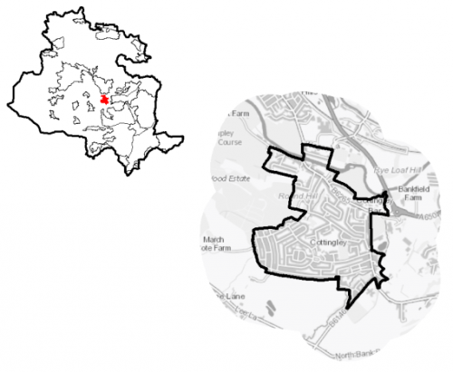
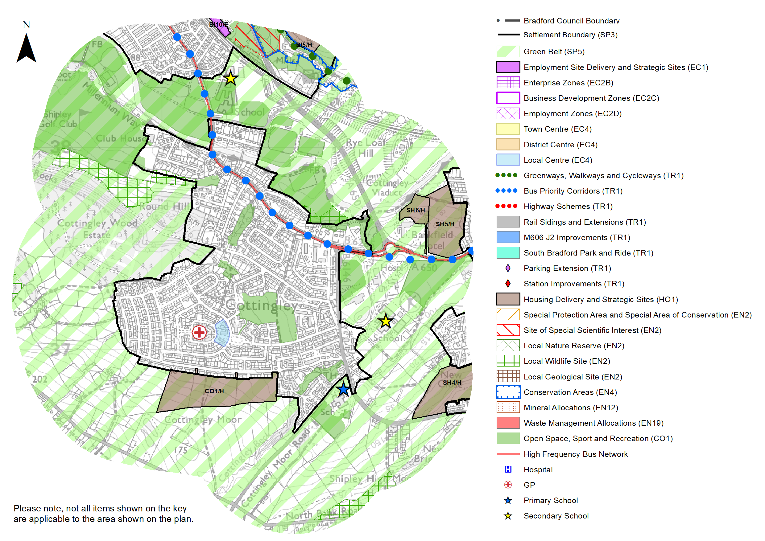
5.10.1 Cottingley is situated in the valley of the River Aire, which flows to the north of the settlement, between Shipley and Bingley. It is around 6km to the north west of Bradford City Centre. It is surrounded by the Bradford Green Belt which separates it from neighbouring settlements (Bradford, Bingley and Shipley). Cottingley Beck flows in a narrow, rocky channel through the south east and the settlement rises up the hillside from the River Aire toward Cottingley Moor. It falls within the Bingley Rural Ward and the Shipley Parliamentary Constituency. Bingley Town Council acts as the administrative body for the settlement.
Figure 1: Location Plan
5.10.2 The settlement is a primarily residential area and functions as a commuter settlement with good connections to nearby towns and cities including Keighley, Bingley, Bradford and Leeds, but does contain a small local business park which provides employment. There are also a range of local services and facilities to support the local population.
5.10.3 Cottingley has a resident population of 4,905. The majority of the population (57.5%) is of working age, which is below the West Yorkshire and national levels (62.8% and 62.4% respectively), however it also has a higher percentage of residents (22.7%) who are aged 65 and over, compared to the sub-regional level (16.7%). The proportion of the population aged 15 and under is slightly above that of West Yorkshire but lower than national levels. The largest majority (88.6%) of the population identify as being of White British ethnicity which is higher than the West Yorkshire level. In terms of household composition, the largest proportion consists of married and cohabiting households (46.2%), compared to a West Yorkshire level of 43.1%. 23.3% of households consist of those aged 65 and over, which is above the West Yorkshire level.
5.10.4 The Town Council is working to prepare of a Neighbourhood Plan that will help to shape how Bingley and Cottingley will grow and develop in the coming years (up to 2030). It sets outs local priorities and policies that will be used, once adopted, as part of the statutory development plan to make decisions on planning applications in the town
Planning for Prosperity
5.10.5 The Local Plan settlement hierarchy identifies Cottingley as a Local Service Centre. This means that it the emphasis will be on a smaller scale of development comprising both market and affordable housing, together with the protection and enhancement of those centres as attractive and vibrant places and communities, providing quality of place and excellent environmental, economic and social conditions.
5.10.6 Cottingley ranks were low in terms of overall deprivation. The exception is in the crime domain. However, this is still lower than the sub-regional average of the percentage of residents living in neighbourhoods ranked within the most deprived (20%) in England (see Figure 2).
Figure 2: Deprivation
|
Number of people in Cottingley living in the most deprived 20% of areas of England by Indices of Deprivation (ID) 2019 domain |
||||||
|
Index of Multiple Deprivation |
Income domain |
Employment domain |
Education domain |
|||
|
0 |
0 |
0 |
0 |
|||
|
(West Yorkshire average = 36.2%) |
(West Yorkshire average = 31.9%) |
(West Yorkshire average = 32.4%) |
(West Yorkshire average = 35.3%) |
|||
|
Health domain |
Barriers to Housing and Services domain |
Living Environment domain |
Crime domain |
|||
|
0 |
0 |
0 |
1,648 |
|||
|
-(West Yorkshire average = 33.8%) |
(West Yorkshire average = 1.8%) |
(West Yorkshire average = 39.8%) |
33.6% (West Yorkshire average = 48.2%) |
|||
|
Source: Ministry of Housing, Communities and Local Government (Indices of Deprivation 2019) |
||||||
Economy and Employment
5.10.7 Economic activity rates for Cottingley are positive 71.3% of the resident working age population being classed as economically active. This is above both the West Yorkshire (68.5%) and national (England) (69.9%) levels. The largest proportion (42.2%) are in full time employment, which again is higher than regional and national levels. The number of self-employed is lower than the national average. Annual household income is £43,700, higher the West Yorkshire average of £38,499. Incomes are reflective of job types with higher percentages of the local population working in managerial, professional and administrative/ secretarial occupations.
5.10.8 Whilst Cottingley is mainly a commuter settlement for nearby major towns and cities, there is a local employment base. Cottingley Business Park, located close to the junction of B6265 Bradford Road and B6164 Cottingley New Road, is a substantial modern business park providing a variety of purpose built and converted office accommodation, and is home to a number of small businesses. Other nearby employment areas are located in Bingley and Shipley, whilst there is good access to Bradford City Centre and Keighley. There are some larger employers within the vicinity of Cottingley, namely the Mercure Bankfield Hotel and the Yorkshire Clinic which are located just outside the boundary on the A650.
5.10.9 Business Register and Employment Survey (BRES) data indicates that the three largest industry groups by workforce jobs (all people in employment) are health (39.5%), education (23.7%) and construction (7.4%).
Retail
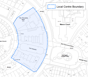
5.10.10 Cottingley is designated in the retail hierarchy (Policy EC4) as a Local Centre. It is focussed on The Parade, in addition to a small number of community and service facilities directly adjacent on Airedale Avenue and Littlelands. The centre boundary is shown on the Policies Map as well as Figure 3 (below). It consists of two convenience stores, a pharmacy, butchers, 2 hairdresser's/beauty salon, laundrette, DIY shop, public house, three takeaways and a café. There is a post office, located within one of the convenience stores. Convenience uses are double the national average, with comparison uses being below. Vacancy rates are above the national average. Overall, it is considered to be a healthy centre that serves the daily needs of the immediate local population. It is also accessible due its location with a residential area, and is in a good state of repair.
Figure 3: Cottingley Local Centre
Transport and Access
5.10.11 Cottingley is located within the key transport corridor running through the Aire Valley, providing good road and rail connections to nearby major towns and cities. It lies to the south of A650, the main route through the Aire Valley between Bradford, North Yorkshire and East Lancashire. This gives access to other towns within Airedale including Keighley, Shipley, Silsden and Steeton with Eastburn as well as to Bradford and Skipton. The B6265 Bradford Road runs through the village linking it with Bingley and to the A650, whilst the B6164 Cottingley Moor Road and B6269 Cottingley Cliffe Road provide secondary links to Bradford.
5.10.12 Public transport links to and from Cottingley are considered good, consisting of high frequency bus services providing connections to Bingley, Bradford City Centre (via Allerton and Shipley), Eldwick, Keighley, Leeds and Shipley. A less frequent service provides a link to the city centre via Bradford Royal Infirmary. The village is not located on a railway line. The nearest railway stations are located on the electrified Airedale Line in Bingley and Saltaire, around 1.2km to the north west and 2km to the north east. These provide frequent links to Bradford Forster Square, Keighley, Leeds, Shipley and Skipton. Bingley is also a stop for services to Carlisle (via the Settle & Carlisle Line) and Lancaster (via the Bentham Line).
5.10.13 Cottingley has a higher than average level of car ownership compared to the West Yorkshire and national (England) averages. 80.3% of households have access to one or more cars or vans compared with 70.5% and 74.3% respective. Consequently, a lower proportion of households (19.6%) have no access to a car or van compared with a sub-regional average of 29.4%. Cottingley is not covered by an Air Quality Management Area (AQMA) and lies outside the proposed Clean Air Zone (CAZ).
5.10.14 In relation to digital connectivity, average broadband download speeds in Cottingley is just over 57 megabytes per second – above the West Yorkshire average, whilst there are no premises where speeds are below the Universal Service Obligation (USO)[1].
5.10.15 Strategic transport infrastructure projects to be delivered within the plan period and protected routes are set out on the Policies Map with the local plan. There are no specific planned improvements for Cottingley with the exception of a bus priority corridor (TR1.C.2) along Bradford Road.
Planning for Homes
5.10.16 Cottingley has 2,082 dwellings, the majority of which, 76.6%, are owner occupied. This above the average for West Yorkshire (63.4%) and England (64.1%). The level of renting (23.4%) is below the West Yorkshire (36.6) and national averages (35.9%), with private and other forms of renting being largest proportion (see figure 4).
Figure 4: Housing Tenure in Cottingley
|
Owner occupied |
Owner-occupied: owned outright |
Owner-occupied owned: with mortgage or loan |
||
|
1,595 |
706 |
874 |
||
|
76.6% (West Yorkshire average = 63.4%) |
33.9% (West Yorkshire average = 28.8%) |
42.0% (West Yorkshire average = 34.1%) |
||
|
Owner-occupied: shared ownership |
Social rented households |
Rented from Council |
||
|
15 |
244 |
100 |
||
|
0.7% (West Yorkshire average = 0.5%) |
11.7% (West Yorkshire average = 18.8%) |
4.8% (West Yorkshire average = 12.5%) |
||
|
Rented from Housing Association or Social Landlord |
Rented from private landlord or letting agency |
Other rented dwellings |
||
|
144 |
203 |
40 |
||
|
6.9% (West Yorkshire average = 6.2%) |
9.8% (West Yorkshire average = 15.0%) |
1.9% (West Yorkshire average = 2.8%) |
||
|
Source: Census 2011 |
||||
5.10.17 The largest proportion (48.6%) of Cottingley's housing stock consists of semi-detached dwellings, which is above the West Yorkshire average (36%), whist the number of detached and terraced dwellings as well as flats are lower. The majority of dwellings (70.6%) were built between 1945 and the present day. Only 4.8% were built before 1900. The average house price for Cottingley is £168,273 compared with a West Yorkshire average of £183,194. Prices are generally below the West Yorkshire average for detached and terraced dwellings as well as flats. Only semi-detached dwellings are above the sub-regional average price.
5.10.18 The total affordability ratio between house prices and annual earnings which is usually used as a proxy for number of years' worth of earnings required for a house deposit is 3.24 compared to a West Yorkshire average of 2.96.
5.10.19 Delivering new housing is a key part of the overall development strategy for Cottingley. It will ensure that the housing needs and aspirations of local people can be met, together with those of future residents, including the provision of market and affordable housing. In addition, it will support the economy and reflect its role as a Local Service Centre.
5.10.20 Policy SP8 sets out a requirement of 150 dwellings that will be delivered in Cottingley during the plan period. These will be delivered through a mix of committed sites (those under construction or have planning permission but have not yet commenced) and site allocations. Table 1 below sets out the housing position for Cottingley which also includes application of non-implementation or discount rates for planning permissions and allocations. The Council will be supportive of additional proposals for new homes on additional small sites, particularly those that provide a redevelopment opportunity to bring forward land which has been previously used. Support will also be provided to developers who wish to redevelop larger sites and/or buildings for new homes not currently identified, subject to all relevant policies in the Local Plan.
Table 1: Cottingley – Summary of Housing Requirement & Supply
|
Housing Target |
150 units |
|
Carried Forward Commitments |
3 |
|
Commitment Discounted by 10% |
3 |
|
Remaining Allocation Requirement |
147 |
|
Identified Allocations |
155 |
|
Allocations Discounted by 10% |
140 |
|
Total Supply Contribution from Allocations |
140* |
*See Table A
5.10.21 Cottingley's allocation is one site which is currently in the Bradford Green belt. The development of this site should be in accordance with specified development guidelines and approximate site provision figures and all other relevant policies of this Local Plan. In delivering the target for new homes in Cottingley, it has been necessary to make some changes to the adopted green belt. Policy SP5 sets out The Councils approach and justification for green belt releases to accommodate new development and lists the sites proposed for allocation which current lie within or partly within the green belt
Planning for Places and Communities
Green Belt, Natural Landscape and Historic Character
5.10.22 Cottingley is surrounded by Green Belt. This land falls within the Airedale and Wilsden Landscape Character Areas, to the north and south respective. The prevailing landscape character is floodplain pasture (to the north), wooded incline (to the north east and north west), mixed upland pasture (to the south east), enclosed pasture (to the south) and parkland (to the north west). The strength of character is either strong (wooded incline – Wilsden; Parkland) or moderate, whilst their historic continuity is either medium or high. Visual prominence and enclosures varies between areas. The Landscape Character Assessment notes that wooded incline areas are sensitive to change, whilst the mixed upland pasture and parkland areas are moderately sensitive to change. The floodplain pasture and enclosed pasture is considered not to be sensitive.
5.10.23 There are no designated Conservation areas within Cottingley. The historic core of the settlement is centred on Main Street and Hollins Street as well as Bradford Road, close to the Cottingley Bridge. There are a total of 4 Listed Buildings within the settlement boundary, with a further 5 situated in the surrounding area to the south west of the village and to the south east close to the edge of Shipley. The majority (eight) of these buildings are Grade II Listed. There is one Grade II* Listed Building - Barn Immediately East of New Close Farmhouse. Saltaire World Heritage Site (WHS) is located around 1.8km to the north west. Cottingley lies outside of the WHS buffer zone, however there are some views from around the settlement towards the WHS.
Green Infrastructure, Ecology, Open Space and Flood Risk
5.10.24 The settlement has a number of corridors and spaces that contribute towards is Green and Blue Infrastructure network. Key corridors include the valley of the River Aire, which covers the northern part of the settlement, and Cottingley Beck, which flows through the south east of the village in steep sided, wooded valley to join the River Aire. The Harden Beck green infrastructure corridor includes part of the western edge of the settlement and Cottingley Park.
5.10.25 Cottingley has two biodiversity designations within and adjacent to its boundary in the form of Local Wildlife Sites (LWS). Rye Loaf Hill LWS is located to the north of village, adjacent to the River Aire, whilst the Hazel Beck LWS is situated to the west, to the south of Hazel Beck and including the wooded slope of Cottingley Park. This area (Cottingley Park) is classified as an ancient woodland. There are also a number of areas around the settlement that form part of the district's habitat network including areas of allotments, grassland and woodland. The South Pennine Moors SPA/SAC (and SSSI) is around 4.1km and 9.8km to the north and south west respectively. This places the whole settlement with 7km buffer of the SPA/SAC.
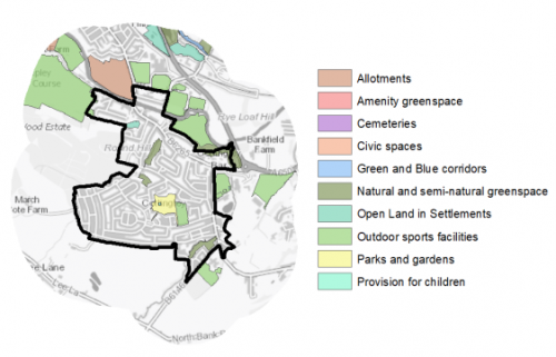
5.10.26 In addition, there are 19 open spaces, totalling around 63ha of land. Key sites within the village include Cottingley Recreation Ground and Shipley Golf Course. Cottingley has a good distribution of sites throughout and on the edge of the settlement, although there are deficits of a number of typologies. It considered that the plan should look to increase provision of Amenity Greenspace. Figure 5 illustrates the type and location of open space in and on the edge of Cottingley.
Figure 5: Cottingley - Open Space Overview
5.10.27 Fluvial flood risk is generally associated with the River Aire to the north of Baildon. There are however identified areas of surface water flood risk across the village associated with several watercourses, including Cottingley Beck, that flow through it as well as parts of the highway network.
Community Infrastructure – Education, Health and Utilities
5.10.28 The village has a number of community facilities that contribute to the day to day needs of local people. These include several places of worship, two community centres/halls and a public house. Other facilities include a golf course (Shipley Golf Club) and the Nuffield Health Cottingley Fitness and Wellbeing Gym. Cottingley Recreation Ground provides opportunities for sport and leisure.
5.10.29 Cottingley Village Primary School serves the local population and is located outside of the main built settlement within the Green Belt. It has capacity for 472 pupils. Other primary schools are located in Bingley (Myrtle Park Primary School and Trinity All Saints CE Primary School) and Allerton (Sandy Lane Primary School). Secondary education is provided at nearby the Dixons Cottingley Academy. It has capacity for 300 pupils. It does not have 6th Form provision. Other schools within a reasonable distance include Beckfoot Academy (Bingley), Belle Vue Girls Academy and Beckfoot Upper Heaton Academy. The first and second have 6th provision. In addition to the 6th Form provision at the secondary schools, local students have the opportunity to access post 16 education at nearby Further Education colleges including Bradford College and Shipley College. Universities in Bradford and Leeds are also within reach. Pupils attainment levels at Key Stages 1 & 2 are slightly above the West Yorkshire and national (England) average score. For Key Stage 4 (GCSE) is above the West Yorkshire and national (England) average scores – 372.8 compares to 353.5 and 366.3 respectively.
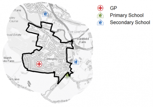
5.10.30 The village is served by Cottingley Medical Practice, located on Canon Pinnington Mews. It is a branch of the Saltaire and Windhill Medical Partnership. The practice group has 19 GPs and serves over 24,000 registered patients. Residents are also served by two health centres (three medical practices) in Bingley. These have 23 GPs and serve 25,000 registered patients. Secondary (acute) healthcare is provided by Bradford Royal Infirmary and Airedale General Hospital. Average life expectancy at birth for Cottingley residents is 81 for men and 84 for women, slightly above the West Yorkshire and England averages. Healthy life expectancy is 66 for men and 67 for women. Figure 6 shows the location of local services in and on the edge of the village
Figure 6: Schools & Medical facilities in Cottingley
5.10.31 Cottingley is served by the Dowley Gap Waste Water Treatment Works, located around 500m to the north of the settlement boundary. This is owned and operated by Yorkshire Water. It also serves Bingley, Cullingworth, Harden and Wilsden.
5.10.32 When planning for the long-term development of Cottingley, it is vital that new development is supported by the appropriate infrastructure. The capacity, quality and accessibility of services and facilities are all key components in ensuring people can enjoy living, working and visiting the area. The council will continue work with key infrastructure providers and others including the Local Education Authority, Clinical Commissioning Group and utilities providers to determine the impacts of future growth and development on local infrastructure capacity and provision. Further infrastructure details will be published through the Local Infrastructure Plan and as part of the Regulation 19 stage of the local plan.
|
Local Area Strategy and Plan - Cottingley |
|
The key elements of the local strategy for Cottingley include:
|
(35) Consultation Question 102
Cottingley Local Area Strategy
The Local Plan sets out a series of local area strategy for Cottingley.
Q. Please provide any comments you may have on the area strategies?
If you have an alternative to the approaches undertaken, please provide further details and evidence in support.
Cottingley - Preferred Site Allocations
5.10.33 The preferred site allocations for Cottingley are set out in Table 1 above and are further detailed in the site pro formas detailed below.
|
Site Ref |
Site Name |
Dwellings / Other Uses |
|
CO1/H |
Marchcote Lane |
155 |
|
Total |
155 |
*The former Sun Public House received planning permission after 1st April 2020. It is not currently identified on the plan, but nevertheless will contribute toward the target.
(37) Consultation Question 103
Cottingley Site Allocations and Site Pro Formas
The Local Plan sets out a series of preferred site allocations. If you wish to make representations on any of the sites proposed, please provide site reference and feedback under this question.
If you wish to propose an additional or alternative site(s) to the preferred allocations listed, please also provide a plan with a red line and any further details in support.
[1] Universal Service Obligation (USO) - download speeds at or above 10Mbit/s and upload speeds at or above 1Mbit/s including non-matched records and zero predicted speeds
(131) CO1/H - Marchcote Lane
Site location
Local Service Centre - Cottingley
Ward
Bingley Rural
Site description
The site consists of several agricultural fields that are used for grazing. A number of trees are present within and adjacent to the site, forming part of the boundaries.
Proposed Allocation
Housing
SHLAA referencce
CO/002
Indicative no. dwellings
155
Site area (Gross) (ha)
8.45
Ownership
Private
Delivery timescales
Developable (6-15 years)
Type (PDL/Greenfield)
Greenfield
Green Belt
Yes
Flood Zone
Flood Zone 1
Potential site access
Potential access points from March Cote Lane (to the north) and Lysander Way (to the east).
Public Transport Accessibility
Bus: The nearest bus stops are located around 100m to the north of the site on Airedale Avenue. These offer 1 service per hour (westbound) towards Bingley and 4 services per hour (eastbound) towards Bradford City Centre.
Rail: The nearest railway stations are Bingley (2.3km to the north west) and Saltaire (2.6km to the north east).
Sustainability Appraisal
The site could deliver a major positive effect for residents on the health SA Objective, as a result of being within the target distances for all necessary health facilities.
Minor positive effects were predicted for most socio-economic themed SA Objectives due to the benefits of new residential development for the local economy as well as the location of the site in relation to transport links, local amenities and employment areas. However, access to both primary and secondary schools is somewhat limited due to distance.
No major adverse effects have been predicted for the site, but minor adverse effects were predicted for a range of natural environment themed SA Objectives, primarily as a result of the impacts of new development on a 100% greenfield site. Minor adverse effects were also predicted for cultural heritage due to the adjacent Class II site (West Yorkshire Archaeology) and the Listed Building 45m north-east.
Habitats Regulations Assessment
This site falls within 7km of the South Pennine Moors SPA/SAC. An HRA must be undertaken to ensure there are no significant effects on these protected sites. Developments within these zones must comply with Policy SP11; a SPD is being produced to provide further guidance.
Green Belt
Based on planning judgement the site has a moderate potential impact on the Green Belt.
• The site is located in a moderate Green Belt parcel.
• The site makes a moderate contribution to the purposes of including land in the Green Belt.
• The site has a major potential for sprawl and would have a major impact on openness.
• There are no opportunities to create a stronger Green Belt boundary than the existing boundary.
Constraints and Opportunities
• This is a sloping, greenfield site within the Green Belt adjoining the settlement boundary for Cottingley.
• The site specific Green Belt assessment indicates that it has a moderate potential impact. It consists of agricultural fields.
• A Public Right of Way runs across the site from north to south.
• Sensitive receptors (existing residential properities and public right of way) adjacent to, and within, the site.
• Potential surface water flooding and pooling at eastern edge.
• Potential impact on the setting of a Listed Building (Grade II) adjacent to the north east corner of the site.
• Archaeological site (Grade II) adjacent to the site.
• Close to but not within Saltaire World Heritage Site buffer zone.
• It is within the 7km buffer of the SPA/SAC.
Development considerations
• Provision of compensatory improvements to the surrounding Green Belt which may include enhancement of the existing rights of way within the site.
• An ecological assessment will be required.
• A Flood Risk Assessment will be required (site is over 1ha).
• A landscape impact assessment will be required to assess the impact of development on the wider landscape.
• Heritage/archaeology assessment will be required.
• A sensitive design and layout will be required, including consideration of topography, building heights and appropriate screening to mitigate any impact on the landscape.
• Consideration should be given to impact on views into and setting of Saltaire World Heritage Site.
• Consideration should be given to determining the most appropriate point for vehicular and pedestrian access as well as impacts on the wider highway network.
Conclusion/Summary
This is a sustainable site located adjacent to the site boundary. It would deliver an estimated 155 dwellings but will require a sensitive design and layout to mitigate potential impacts on existing residential properties and the wider landscape.