
Draft Bradford District Local Plan - Preferred Options (Regulation 18) February 2021
Thornton
Introduction
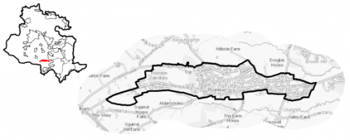
5.26.1 The village of Thornton is located within the South Pennine sub- area of Bradford District and is located approximately 6.5km west of Bradford, 3km north of Queensbury and 9km south-east of Keighley. It is largely residential in nature, with some local services; it is a commuter settlement for Bradford. Thornton is also notable culturally as the Bronte sister's birthplace is located here.
5.26.2 Thornton falls within the Bradford West Parliamentary Constituency and lies within the Thornton and Allerton Ward. It is a linear settlement situated on a northern hillside of Pinch Beck Valley, with a spine road of the B6145 (Thornton Road) running along the valley floor on the Sothern side of the settlement; the B6145 connects Bradford with the A629.
Figure 1: Location Plan
5.26.3 The settlement has a total population of 5,881 and a high percentage of this (61.8%) falls within the working age category (16-64). The age profile of the settlement is comparable to the West Yorkshire average with a slightly higher percentage of over 65s (18.6% compared to the sub-regional average of 16.7%). The ethnic composition of Thornton is primarily made up of people who identify themselves as White British - accounting for 92.3%. This is a notably higher proportion than the West Yorkshire average (78.4%), but is similar to other smaller rural settlements in the District.
Planning for Prosperity
5.26.4 Thornton is identified as one of six Local Growth Centres (alongside neighbouring Queensbury). This means that it is identified as an accessible, attractive and vibrant place to live, work and invest should be enhanced. Being location along a key road and public transport corridor, there is an expectation that it will make a significant contribution to meeting the District's needs for housing, employment and provide for supporting community facilities.
5.26.5 24.3% of individuals living in Thornton are amongst the 20% most deprived neighbourhoods in England. Figure 2 shows the overall picture of deprivation in the area with 1 being the most deprived and 10 the least
Figure 2: Index of Multiple Deprivation 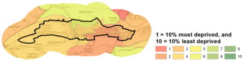
Economy and Employment
5.26.6 Economic activity rates are slightly higher for Thornton with 72.2% of the resident population economically active compared to the West Yorkshire average (68.5%). Average household income at £40,500 is just slightly higher than the West Yorkshire average (£38,499). The main employment sectors that the residents of Thornton work in include retail, health and social work and education.
5.26.7 There are some employment opportunities within the village such as financial and domestic services, retail, beauty and hospitality. South Square Centre is a collection of 19th Century workers' cottages which is home to ten artists' studios, as well as a gallery, community spaces, art framers, bar and a cafe. There are also employment opportunities in Fireclay Business Park to the west of the settlement. This includes builder's supplies, retail and automotive services. Thornton is also a Local Growth Centre serving as a hub for the rural population of the neighbouring South Pennine villages such as Keelham, Denholme and Wilsden. In order to access a wider range of employment opportunities, residents need to commute to the larger centres of Bradford, Keighley and Halifax.
5.26.8 Business Register and Employment Survey (BRES) data indicates that the three largest industry groups by workforce jobs (all people in employment) are: education (17.6%), health (16.9%) and retail (13.7%).
Retail
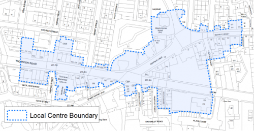
5.26.9 The main concentration of retail uses is focused at the junction of Thornton Road, Kipping Lane and Lower Kipping Lane. Market Street was originally the main town centre and over time, the centre has shifted and developed along Thornton Road.
5.26.10 All retail centres have been subject to a review as part of the Retail and Leisure Study (2019). It concluded that Thornton has a healthy centre with a good environmental quality. In addition to three convenience stores it identified that Thornton caters for the higher-end comparison goods market such as art shops and art galleries in addition to a furniture store, auction house, florist, pet supply store and a DIY store. It has below average retail offering and an above average number of leisure service units comprised of; seven takeaways, three public houses, two bars, two cafes, two restaurants and a social club. This is possibly due to its connections to the Bronte's and role as a tourist destination. Figure 3, shows the extent of the Thornton Local Centre.
Figure 3: Thornton Local Centre
Transport and Access
5.26.11 Thornton benefits from good access to the wider road network, the B6145 (Thornton Road) runs along this linear settlement. The B6145 connects Bradford with the A629, an inter-Yorkshire road that runs from Skipton, in the north to Rotherham, in the south, passing through Keighley, Halifax, Huddersfield and Chapeltown. A number of minor roads connect Thornton to other settlements to the north, south and east (Wilsden, Queensbury and Denholme) and with Clayton and the wider Bradford urban area to the west.
5.26.12 Thornton is served by frequent (every 12 to 15 minutes) bus services operated by First Bradford towards Bradford (via Four Lane Ends) and a less frequent hourly service is provided by the Keighley Bus Company to Keighley (via Denholme and Cullingworth). Leeds Bradford International Airport is 15 km away.
5.26.13 There are no train services running through Thornton, however, the twenty-arch Grade II listed Thornton Viaduct (a prominent feature in the landscape, crossing Pinch Beck valley) is now a busy walking and cycle route, and forms part of the Great Northern Railway Trail and National Cycle Network route 69 which, though disjointed, provides a link between Cullingworth and Queensbury.
5.26.14 In relation to digital accessibility, average broadband download speed in Thornton is almost 49 megabytes per second which is above the West Yorkshire average of 44.57. There are 3 premises where speeds are below the Universal Service Obligation (USO)[1].
Planning for Homes
5.26.15 Thornton has 2,763 dwellings which are mostly owner occupied (73%), this is higher than the regional average (63.4%). 11% are socially rented compared to the regional average of 19%.
5.26.16 There are a mix of house types in Thornton with the highest proportion being mainly older terraced properties located around the central historic core settlement (40%). Semi-detached (35%) and detached (16%) properties being the dominant dwelling type in the newer housing estates, mostly to the north and west of the settlement. 40% of the village's houses were built prior to 1900 which is much higher than the regional average (18%). 17% of the stock has been added since the year 2000 which is higher than the regional average of 14%.
5.26.17 The average house price in Thornton is £115,554 (2020), average house prices in Thornton are significantly below regional averages for all house types. This would equate to an income multiplier of 3.24.
Figure 4: Thornton – House Prices
|
Average house price (all types of housing) (Land registry Sept-19 to August-20) |
Average house price (detached) (Land registry Sept-19 to August-20) |
Average house price (flats) (Land registry Sept-19 to August-20) |
||
|
£115,554 |
£223,667 |
£73,167 |
||
|
West Yorkshire average = £183,194 |
West Yorkshire average = £324,872 |
West Yorkshire average = £128,299 |
||
|
Average house price (semi-detached) (Land registry Sept-19 to August-20) |
Average house price (terraced) (Land registry Sept-19 to August-20) |
Households in Council Tax Band A (Valuation Office Agency (VOA) 2020) |
||
|
£123,500 |
£89,571 |
991 |
||
|
West Yorkshire average = £178,439 |
West Yorkshire average = £132,430 |
36.4% (West Yorkshire average = 43.1%) |
||
|
Households in Council Tax Band B (VOA 2020) |
Households in Council Tax Band C (VOA 2020) |
Households in Council Tax Band F-H (VOA 2020) |
||
|
595 |
576 |
110 |
||
|
21.8% (West Yorkshire average = 20.2%) |
21.1% (West Yorkshire average = 17.6%) |
4.0% (West Yorkshire average = 4.3%) |
5.26.18 The delivery of new housing is a key part of the development strategy for Thornton. This will ensure that the housing needs of local people can be met, both in terms of market and affordable housing. New housing will also allow for the modest growth of the settlement, to attract new residents and to help sustain the provision of services and facilities.
5.26.19 Policy SP8 in the local plan sets out a minimum requirement of 575 dwellings to be delivered in Thornton during the plan period. These will be delivered through a mix of committed sites (those under construction or have planning permission but have not yet commenced) and allocations. Table 1 below sets out the housing position for Thornton, which also includes the application of non-implementation or discount rates for planning permissions and allocations.
Table 1: Thornton - Summary of Housing Requirement and Supply
|
Housing Target |
575 units |
|
Carried Forward Commitments |
43 |
|
Commitment Discounted by 10% |
39 |
|
Remaining Allocation Requirement |
536 |
|
Identified Allocations |
618 |
|
Allocations Discounted by 10% |
556 |
|
Total Supply Contribution from Allocations |
556 |
5.26.20 Once the commitments are discounted and removed from the supply, this leaves a residual allocation requirement of 536 units. The evaluated total site supply of housing units from the preferred allocation site equates to 618 units which is in turn discounted by 10% for non-implementation or under delivery leaving a final allocation contribution of 556 units.
5.26.21 A portfolio of eleven sites has been identified as the preferred housing options for Thornton to meet the housing requirement. These consist of two Brownfield sites (Dale and Prospect Mill and Old Road), four greenfield sites within the settlement (the majority of which will form the West Thornton Masterplan area) and three Green Belt sites. In delivering the target for new homes in Thornton it has been necessary to make some changes to the adopted green belt. Policy SP5 sets out The Councils approach and justification for green belt releases to accommodate new development and lists the sites proposed for allocation which current lie within or partly within the green belt. The identified sites have the potential to support a wide range of housing types and are set out in Table A. They are also identified on the Policies Map and in the Site Pro-formas below. The development of site allocations should be in accordance with specified development guidelines and approximate site provision figures and all other relevant policies of this Local Plan. The Council will be supportive of additional proposals for new homes on additional small sites, particularly those that provide a redevelopment opportunity to bring forward land which has been previously used. Support will also be provided to developers who wish to redevelop larger sites and/or buildings for new homes not currently identified, subject to all relevant policies in the Local Plan.
Planning for Places and Communities
Green Belt, Natural Landscape and Historic Character
5.26.22 Thornton is surrounded by Green Belt which falls within the Thornton and Queensbury Landscape Character Area and the Yorkshire Southern Pennine Fringe National Character Area. The prevailing landscape of the character is mixed upland pasture, which surrounds the settlement of Thornton. The landscape has been identified as being prominent and open and in declining condition, with moderate strength of character and medium historic continuity.
5.26.23 The settlement is considered as being sensitive to change. However, the factors affecting sensitivity vary widely across the Thornton area, and some parts, for example to the north-west of Thornton, has weak character, and would therefore be assessed as being only moderately sensitive to change. Generally, the prominence of the mixed upland pasture means that any changes which could occur in the landscape would be noticeable and have a large impact on the landscape character.
5.26.24 Thornton Conservation Area is located in the centre of the settlement around its historic core, incorporating Kipping Independent Chapel, Ashfield House, the Bronte's birthplace and numerous other properties. There are a significant number (256) of Listed Buildings within the village, the majority of which are Grade II Listed. There two Grade II* Listed buildings, 74 Market Street (the birthplace of the Bronte Sisters) and Thornton Hall.
Green Infrastructure, Ecology, Open Space and Flood Risk
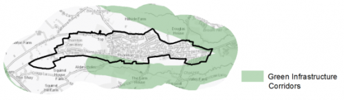
5.26.25 Green Infrastructure (GI) areas run both north and south of the settlement and form part of the District's Green Infrastructure network and should be protected and enhanced. These areas are multi-functional in nature and help to deliver benefits for biodiversity, reduce flood risk, provide public rights of way, and areas of open space. New developments should identify the opportunities to connect into these networks by enhancing natural features that exist on-site and improving the links between sites.Figure 5 shows Thornton green infrastructure connections to the wider area
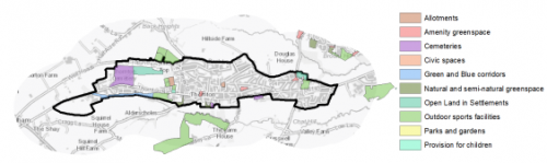
Figure 5: Green Infrastructure Corridors
5.26.26 Thornton has a number of biodiversity designations within or adjoining the village area. The route of the Great Northern Trail including the viaduct, includes priority habitats and is part of the wider habitat network. The east of Thornton is largely surrounded by Grassland habitat network. The South Pennine Moors SPA (and SSSI) is located 1.7km form the settlement's western boundary.
5.26.27 There are 23 open space sites of various types within the settlement which cover a total area of 38.9ha.The key open spaces sites in Thornton include Thornton Cemetery, Thornton Recreation Ground, Royd Street Recreation Ground and Play Area, The Great Northern Railway Trail and Headley Golf Course. These are identified in figure 6. Further priority should be for park provision (there is currently no park in Thornton), play areas and allotment provision.
Figure 6: Thornton – Open Space Overview
5.26.28 The main urban area of Thornton is located on a northern hillside which runs downhill to Pinch Beck meaning that most properties are not at risk of fluvial flooding. There are small parts of the settlement where there is potential for surface water flooding to occur due to the topography and permeability of surfaces in that area, such as steep roads including West Lane, James Street and Springhead Lane and the valley floor. However, flooding on the whole is not a major constraint to development in Thornton.
Community Infrastructure – Education, Health and Utilities
5.26.29 Possibly due to its status as a Bronte tourist attraction, Thornton has a higher than average proportion of leisure uses such as hospitality venues and galleries, South Square also hosts events and has a community space for hire. The residents of Thornton also benefit from a library, community centre, children's centre, two churches and allotments. Thornton Recreation Centre is located to the east of the settlement and provides gym and exercise class facilities.
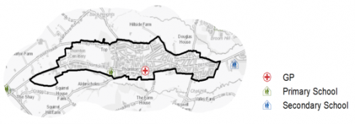
5.26.30 Thornton Primary School is located on Thornton Road, on the site of the former railway station. It has a capacity of 660. Secondary provision (age 11 to 18) is located at Beckfoot Thornton which is on Leaventhorpe Lane slightly to the east of Thornton, within the Green Belt; it has capacity for 1,580 students.
5.26.31 The village is served by one medical facility, Thornton and Denholme Medical Practice, which provides a service to residents of Thornton, Denholme, Keelham and parts of Allerton and Cullingworth. It has around 9,000 patients and has facilities in Thornton and Denholme. There is a pharmacy located within the practice. Secondary (acute) healthcare is provided at Bradford Royal Infirmary and Airedale General Hospital. Figure 7 shows the location of local services.
Figure 7: Thornton – Schools and GP Practices
5.26.32 When planning for the long-term development of Thornton, it is vital that new development is supported by the appropriate infrastructure. The capacity, quality and accessibility of services and facilities are all key components in ensuring people can enjoy living, working and visiting the area. The Council will continue work with key infrastructure providers and others including the Local Education Authority, Clinical Commissioning Group and utilities providers to determine the impacts of future growth and development on local infrastructure capacity and provision. Further infrastructure details will be published through the Local Infrastructure Plan and as part of the Regulation 19 stage of the local plan.
|
Local Area strategy and Plan - Thornton The key elements of the local area strategy for Thornton include:
|

(29) Consultation Question 138
Thornton Local Area Strategy
The Local Plan sets out a local area strategy for Thornton.
Q. Please provide any comments you may have on the area strategy?
If you have an alternative to the approach undertaken, please provide further details and evidence in support.
Preferred Site Allocations and Site Pro Formas
5.26.33 The preferred housing site allocations are detailed below. This table is subsequently followed by site pro forma for each site which provides a summary of key site information and characteristics.
Table A: Housing - Preferred Allocation
|
Site Ref |
Site Name |
Dwellings |
|
TH1/HC |
Hill Top Road (2) |
11 |
|
TH2/H |
Thornton Road (1) |
150 |
|
TH3/H |
Thornton Road (2) |
15 |
|
TH4/H |
Hill Top Road (1) |
10 |
|
TH5/H |
Hill Top Road (3) |
12 |
|
TH6/H |
Dole and Prospect Mills |
50 |
|
TH7/H |
Old Road |
13 |
|
TH8/HC |
Thornton Road West |
250 |
|
TH9/H |
Close Head Drive |
50 |
|
TH10/H |
Hill Top Road, near Ring O' Bells |
27 |
|
TH11/H |
South of Hill Top Road and East of Close Head Lane |
30 |
|
Total |
618 |
(17) Consultation Question 139
Thornton Site Allocations and Site Pro Formas
The Local Plan sets out preferred site allocations for Thornton. If you wish to make representations on the sites proposed, please provide feedback under this question.
If you wish to propose an additional or alternative site(s) to the preferred allocation listed, please also provide a plan with a red line and any further details in support.
[1] Universal Service Obligation (USO) - download speeds at or above 10Mbit/s and upload speeds at or above 1Mbit/s including non-matched records and zero predicted speeds
(14) TH1/HC - Hill Top Road (2)
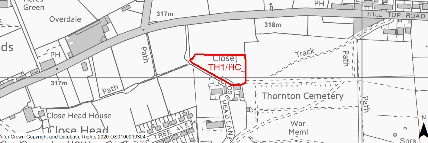
Site location
Local Growth Centre - Thornton
Ward
Thornton and Allerton Ward
Site description
This is a sloping greenfield site.
Proposed Allocation
Housing
SHLAA referencce
TH/002A
Indicative no. dwellings
11
Site area (Gross) (ha)
0.52
Ownership
Council
Delivery timescales
Developable (6-10 years)
Type (PDL/Greenfield)
Greenfield
Green Belt
No
Flood Zone
Flood Zone 1
Potential site access
Site would be accessed from Close Head Lane (improved) off Hill Top Road.
Public Transport Accessibility
Public transport accessibility has been taken into account as part of the planning application process.
Sustainability Appraisal
Development at this site would be unlikely to result in a significant effect, either positive or negative, on any SA Objective.
Minor positive effects were predicted for a range of socio-economic themed SA Objectives due to the benefits of new residential development for the local economy as well as the location of the site in relation to health facilities and employment areas. However, access to transport links, services and amenities, and education facilities is somewhat limited, with residents likely to be required to travel beyond the target distances.
As a 100% greenfield site adjacent to TPO woodland, the development has been predicted to result in minor adverse effects on most natural environment themed SA Objectives.
Habitats Regulations Assessment
The majority of this site falls within 2.5km of the South Pennine Moors SPA/SAC a HRA must be undertaken to ensure there are no significant effects on these protected sites in terms of impact on supporting habitat which might be functionally linked to the SPA and recreational pressures. Developments within these zones must comply with Policy SP11; an SPD is being produced to provide further guidance.
Green Belt
N/A – Site not within the Green Belt.
Constraints and Opportunities
• Relevant constraints and opportunities have been considered as part of the planning application process.
Development considerations
• Relevant development considerations have been taken into account as part of the planning application process.
• Drainage infrastructure – due to the site topography and existing constraints additional detailed work should be undertaken in a comprehensive manner across the proposed development sites to the west of Thornton on planning drainage routes, connections and new drainage infrastructure provision.
• Highways infrastructure – development should avoid excessive vehicle load on Hill Top Road and creating additional traffic flow into West Thornton where possible. The junction of Hill Top Road and Wicken Lane is substandard. The level of development proposed in total will create additional vehicle movement and potential pinch points particularly within the village. Additional detailed work through the strategic transport model will inform the further devQB1/H - Albert Road, Brighouse and Denholme Roadelopment of the local plan and identify whether the growth proposed will be within a tolerable range of impacts on the highways and any mitigation measures which may be necessary.
Conclusion/Summary
This site has outline planning permission for 11 dwellings (16/09443/MAO approved 13.07.17).
(119) TH2/H - Thornton Road
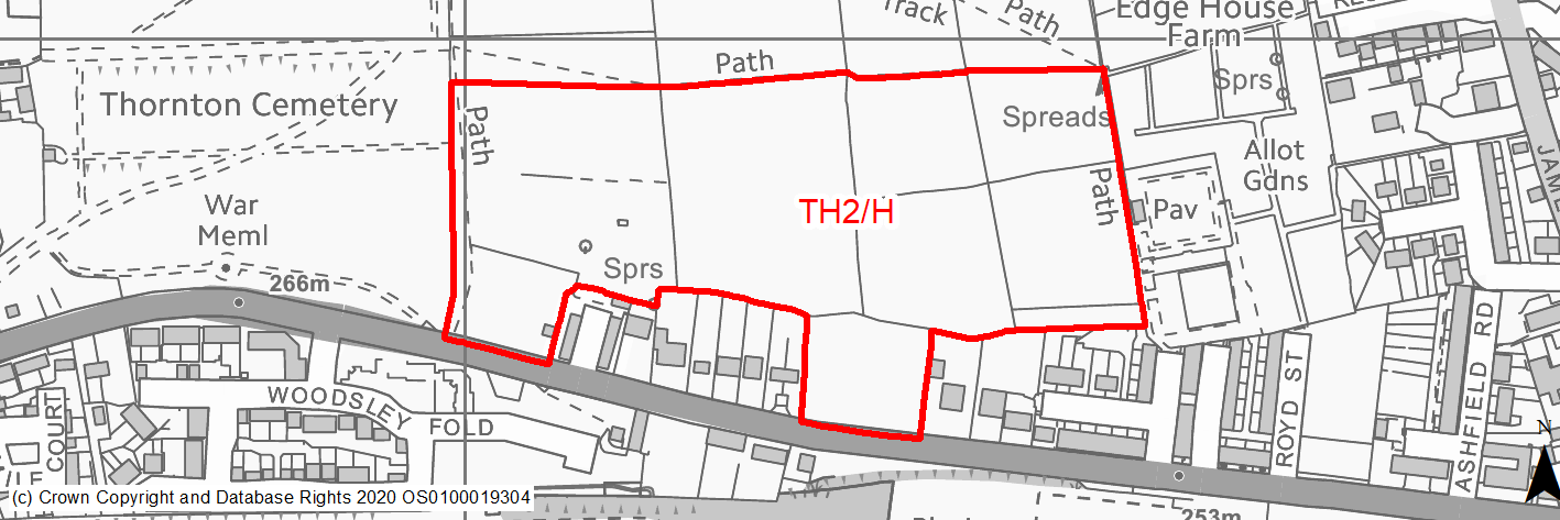
Site location
Local Growth Centre - Thornton
Ward
Thornton and Allerton Ward
Site description
Large area of sloping and level grazing land adjacent to Thornton Road. Part of the site is protected as village Greenspace in the RUDP. The site is within an expanse of open hillside land in the cnetre of the Thornton settlement. The Bronte Way public footpath, which is a draw for tourists and has high cultural significance, runs along north of site. The site consists of several agricultural fields, seperated by dry stone walls.
Proposed Allocation
Housing
SHLAA referencce
TH/003
Indicative no. dwellings
150
Site area (Gross) (ha)
5.87
Ownership
Private / Council
Delivery timescales
Developable (6-10 years)
Type (PDL/Greenfield)
Greenfield
Green Belt
No
Flood Zone
Flood Zone 1
Potential site access
Access via Thornton Road could present some challenges due to levels. Significant splay would be required and substantial ground works to create adequate levels. Site currently has large retaining wall along the boundary.
Public Transport Accessibility
Bus stop adjacent site. Offers frequent service.
Sustainability Appraisal
Development at this site would be unlikely to result in a significant effect, either positive or negative, on any SA Objective.
Minor positive effects were predicted for a range of socio-economic themed SA Objectives due to the benefits of new residential development for the local economy as well as the location of the site in relation to transport links and health and education facilities.
Minor adverse effects were predicted for a range of natural environment themed SA Objectives, primarily as a result of the impacts of new development on a 100% greenfield site which adjoins deciduous woodland priority habitat. There are thirteen Grade II Listed Buildings within 200m of the site; new development at this large, open greenfield site could has the potential to adversely alter the setting of these sensitive heritage assets.
Habitats Regulations Assessment
This site falls within 7km of the South Pennine Moors SPA/SAC. A HRA must be undertaken to ensure there are no significant effects on these protected sites. Developments within these zones must comply with Policy SP11; a SPD is being produced to provide further guidance.
Green Belt
N/A – Site not within the Green Belt.
Constraints and Opportunities
• Development of the site would have a moderate impact on the landscape.
• The site is within a Green Infrastructure Corridor.
• The site is located within the 7km buffer of the SPA/SAC.
• The southern section levels out but north of site slopes steeply. Fronting onto main road has a large retaining wall.
• Portion of the site covered by open space designation.
• Sustainable location with good transport connections.
• The Bronte way runs along the site which is a key public footpath and tourist asset. The Bronte Way public footpath, which is a draw for tourists and has high cultural significance, runs along north of site.
Development considerations
• The site consists of a large open space on a hillside in the centre of the settlement, the Bronte Way which is a draw for tourists and has high cultural significance passes through the centre of this space. A sensitive site design, which incorporates green infrastructure will be required to mitigate any impact on the Bronte Way, Green Infrastructure corridor and the wider landscape.
• Due to the topography and associated retaining wall, drainage and the provision of a new level access from Thornton Road is a major consideration.
• Drainage infrastructure – due to the site topography and existing constraints additional detailed work should be undertaken in a comprehensive manner across the proposed development sites to the west of Thornton on planning drainage routes, connections and new drainage infrastructure provision.
• This site forms part of a wider Master plan area for West Thornton which must be considered cohesively.
Conclusion/Summary
This is a prominent hillside site which is sustainably located within the settlement boundary and near to local services and facilities. It would deliver an estimated 50 dwellings and enhanced open space provision, forming part of the Western Thornton Master plan area it will benefit from cohesive, high quality design principals.
(16) TH3/H - Thornton Road
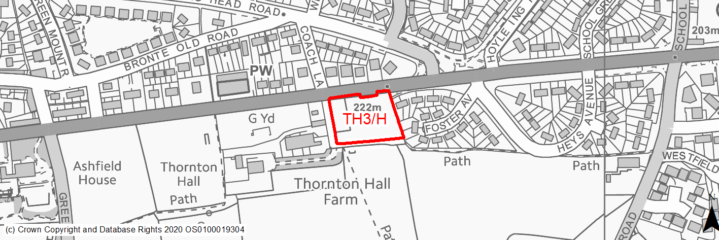
Site location
Local Growth Centre - Thornton
Ward
Thornton and Allerton Ward
Site description
Self contained, former kitchen garden site to the south side of Thornton Road. Adjacent to Thornton Hall. This greenfield site is fairly level with a slight slope to the south, surrounded by fairly high dry stone walls.
Proposed Allocation
Housing
SHLAA referencce
TH/006
Indicative no. dwellings
15
Site area (Gross) (ha)
0.47
Ownership
Private
Delivery timescales
Developable (6-10 years)
Type (PDL/Greenfield)
Greenfield
Green Belt
Yes
Flood Zone
Flood Zone 1
Potential site access
New access required off Thornton Road, existing access down track alongside Thornton Hall. There is a bus stop and waiting area currently located at the access point, this will need to be reconfigured or relocated. The previous planning application included the provision of a new bus stop and shelter.
Public Transport Accessibility
Bus stop adjacent site. Offers frequent service.
Sustainability Appraisal
The site could deliver a major positive effect for residents on the health SA Objective as a result of being within the target distances for all necessary health facilities.
Minor positive effects were predicted for a range of socio-economic themed SA Objectives due to the benefits of new residential development for the local economy as well as the location of the site in relation to transport link and education facilities.
No major adverse effects have been predicted for the site, but it is currently 100% greenfield and on Green Belt land and therefore minor adverse effects were predicted for a range of natural environment themed SA Objectives due to the impacts a new development would have. A Grade II Listed Building adjoins the south-western corner, and an additional Grade II* and three Grade II Listed Buildings are within 130m of the site. Development here could potentially affect the setting of these sensitive heritage assets.
Habitats Regulations Assessment
This site falls within 7km of the South Pennine Moors SPA/SAC. A HRA must be undertaken to ensure there are no significant effects on these protected sites. Developments within these zones must comply with Policy SP11; a SPD is being produced to provide further guidance.
Green Belt
See individual Green Belt site assessment in the accompanying report.
Constraints and Opportunities
• The site is currently designated as Green Belt.
• In setting of LBII* Thornton Hall and within 50m of Grade II Listed stocks.
• Development of the site would have a moderate impact on the landscape.
• Public footpath passes along west and south of site. The site is partially within a Green Infrastructure Corridor.
• The site is located within the 7km buffer of the SPA/SAC.
• Infill land adjacent settlement which is relatively flat and self-contained. Sustainable location with developer interest.
Development considerations
• Adjacent to Grade II listed Thornton Hall and Stocks, appropriate, sensitive design & layout would be required in order to mitigate the impact on them.
• Provision of compensatory improvements to the surrounding Green Belt will be required and may include enhancement of the existing rights of way network adjacent to the site.
• A sensitive design to mitigate any potential landscape impact, which may include consideration of layout and provision of screening where appropriate.
• Vehicular and pedestrian access is available off Thornton Road, although a new junction will be required.
• Relocation of bus stop will also be required.
Conclusion/Summary
This is a fairly small green belt site which would constitute infill of the existing settlement. The site is relatively flat and self-contained and would have a moderate landscape impact which could be partially mitigated through careful design. Impacts on heritage assets must be carefully considered but it is thought they could be mitigated through appropriate design. The site is in a highly sustainable location in close proximity to all of Thornton's facilities.
(16) TH4/H - Hill Top Road
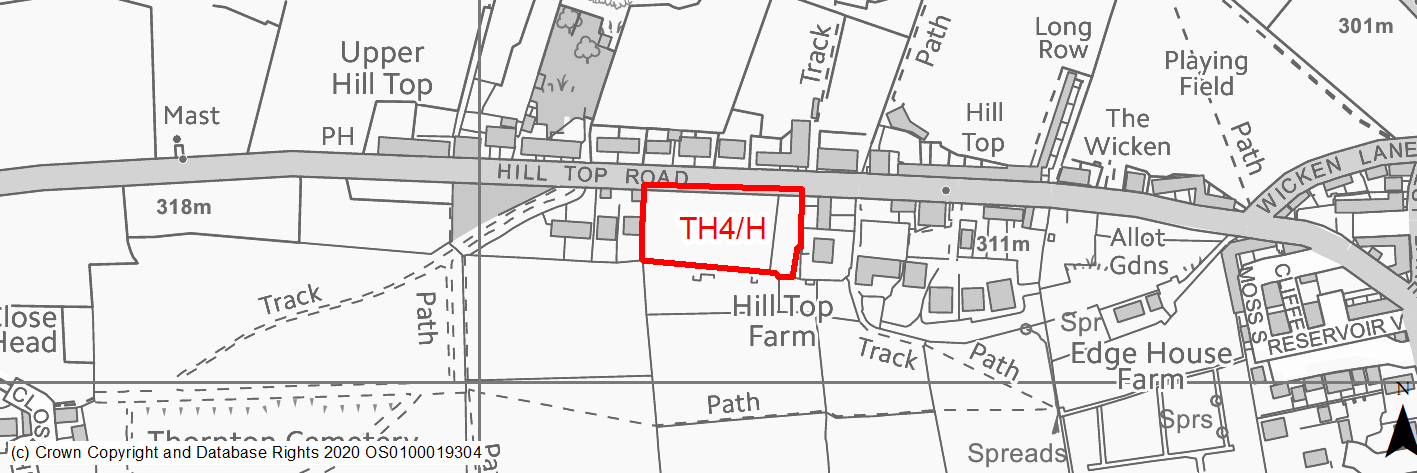
Site location
Local Growth Centre - Thornton
Ward
Thornton and Allerton Ward
Site description
Level to sloping land fronting Hill Top Road. Former allotment gardens. Some dry stone walls and remains of small out buildings present on site. Prominent hillside location overlooking Thornton and surrounding valley.
Proposed Allocation
Housing
SHLAA referencce
TH/009
Indicative no. dwellings
10
Site area (Gross) (ha)
0.52
Ownership
Private
Delivery timescales
Developable (6-10 years)
Type (PDL/Greenfield)
Greenfield
Green Belt
No
Flood Zone
Flood Zone 1
Potential site access
New access to be taken from Hill Top Road. Visibility is acceptable.
Public Transport Accessibility
Bus stop adjacent site but limited service. Main route 900m.
Sustainability Appraisal
No significant adverse effects predicted for TH4/H (TH/009). Minor adverse effects predicted for most natural environment themed SA Objectives, primarily as a result of effects associated with new development on greenfield. The site generally has good access to key services and amenities, including jobs, shops, buses, cultural spaces, health facilities and schools. However, the site is not within all target distances for any SA Objective and no major positive effects have been predicted.
Habitats Regulations Assessment
This site falls within 7km of the South Pennine Moors SPA/SAC. A HRA must be undertaken to ensure there are no significant effects on these protected sites. Developments within these zones must comply with Policy SP11; a SPD is being produced to provide further guidance.
Green Belt
N/A – Site not within the Green Belt.
Constraints and Opportunities
• Adjacent to row of Grade II listed buildings.
• Development of the site would have a moderate impact on the landscape, development would infill a gap between existing hill top houses. Coppiced hedgerows dissect the site.
• The site is within a Green Infrastructure Corridor.
• The site is located within the 7km buffer of the SPA/SAC.
• Site has poor accessibility due to poor bus services, steep topography and distance to some local services.
Development considerations
• Attention to local distinctiveness and built form would be required to mitigate the affect on the setting of Listed Buildings on Hill Top Road.
• Existing coppiced hedgerows should be retained and incorporated into the site design.
• Drainage infrastructure – due to the site topography and existing constraints additional detailed work should be undertaken in a comprehensive manner across the proposed development sites to the west of Thornton on planning drainage routes, connections and new drainage infrastructure provision.
• Highways infrastructure – development should avoid excessive vehicle load on Hill Top Road and creating additional traffic flow into West Thornton where possible. The junction of Hill Top Road and Wicken Lane is substandard. The level of development proposed in total will create additional vehicle movement and potential pinch points particularly within the village. Additional detailed work through the strategic transport model will inform the further development of the local plan and identify whether the growth proposed will be within a tolerable range of impacts on the highways and any mitigation measures which may be necessary.
• This site forms part of a wider Master plan area for West Thornton which must be considered cohesively.
Conclusion/Summary
Development of the site would infill between houses at the top of Hill Top Road, suitable for approximately 10 dwellings as suffering from poor accessibility and distance to local services by sustainable means. Landscape and heritage concerns could be mitigated through appropriate design. Hedgerows should be retained. Vehicular and pedestrian access is available off Hill Top Road, although a new junction will be required.
(20) TH5/H - Hill Top Road
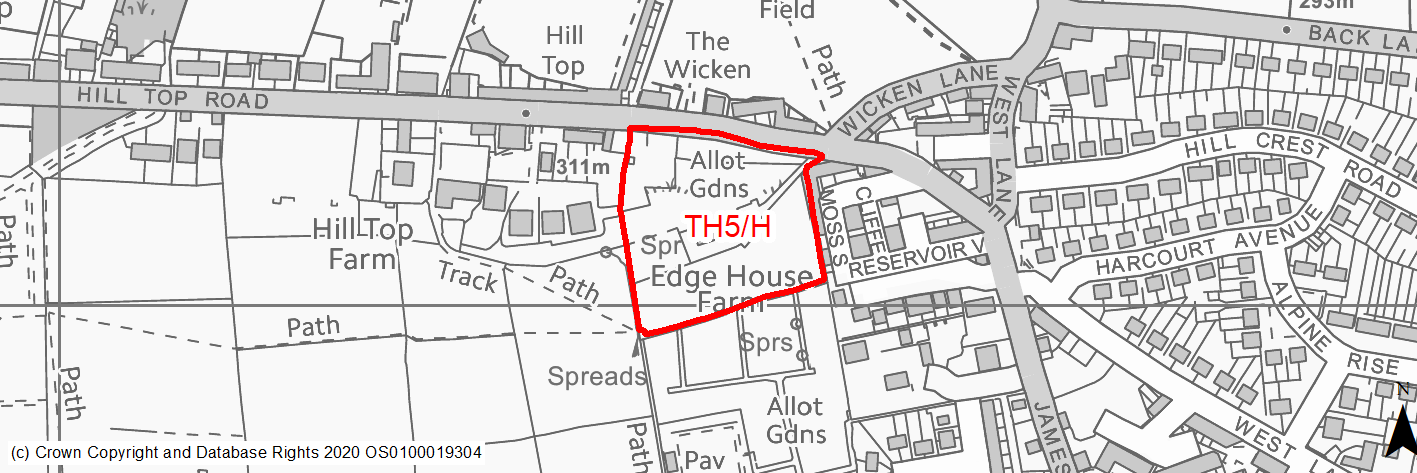
Site location
Local Growth Centre - Thornton
Ward
Thornton and Allerton Ward
Site description
Partially wooded area with single residential property at the centre of the site and further open land below. Site slopes down from north to south. The Bronte Way public footpath, which is a draw for tourists and has high cultural significance, runs along the centre of the site. A telegraph wire also crosses the site.
Proposed Allocation
Housing
SHLAA referencce
TH/010
Indicative no. dwellings
12
Site area (Gross) (ha)
1.31
Ownership
Council
Delivery timescales
Developable (6-10 years)
Type (PDL/Greenfield)
Greenfield
Green Belt
No
Flood Zone
Flood Zone 1
Potential site access
Site can be accessed off Hill Top Road but will require some infrastructure improvements such as a footway along site frontage and could prove challenging. Site currently accessed by a narrow unmade track which emerges at a cross roads with Hill Top Road and Wicken Lane which is narrow and has poor visibility.
Public Transport Accessibility
Bus stop adjacent site but limited service. Main route 600m.
Sustainability Appraisal
Development at this site would be unlikely to result in a significant effect, either positive or negative, on any SA Objective.
Minor positive effects were predicted for most socio-economic themed SA Objectives due to the benefits of new residential development for the local economy as well as the location of the site in relation to transport links, local services and amenities, and health and education facilities.
Minor adverse effects have been predicted for a range of natural environment themed SA Objectives, primarily as a result of the impacts of new development on a predominantly greenfield site with adjacent TPO woodland. Development here could pose a risk to the water quality of a small surface waterbody adjacent to the site. There are thirteen Grade II Listed Buildings within 350m of the site, the nearest adjoining the north-western corner, the settings of which could be adversely affected by the development.
Habitats Regulations Assessment
This site falls within 7km of the South Pennine Moors SPA/SAC. A HRA must be undertaken to ensure there are no significant effects on these protected sites. Developments within these zones must comply with Policy SP11; a SPD is being produced to provide further guidance.
Green Belt
N/A – Site not within the Green Belt.
Constraints and Opportunities
• The site contains a dilapidated dwelling and outhouses to the north and an open field to the south.
• The Bronte Way public footpath, which is a draw for tourists and has high cultural significance, passes through the centre of this space.
• Grade II listed buildings are adjacent to site.
• Development of the site would have a moderate impact on the landscape, long distance views, site slopes north to south. The site is within a Green Infrastructure Corridor.
• The site is located within the 7km buffer of the SPA/SAC.
• Low voltage pylons cross the site.
• Site has poor access from a single lane, unmade track, the egress being at an angle to the busy Hill Top Road at the junction with Wicken Lane.
• Site has been identified as having potential alternative uses as a tree planting area and/or allotments.
• Somewhat detached form local services due to poor public transport and topography.
Development considerations
• Access forms the most significant constraint to the site, unclear whether access from Hill Top Road could be made good, potential to consider access from the south through the Western Thornton Master plan area.
• Highways infrastructure – development should avoid excessive vehicle load on Hill Top Road and creating additional traffic flow into West Thornton where possible. Access to site at the junction of Hill Top Road and Wicken Lane is substandard. The level of development proposed in total will create additional vehicle movement and potential pinch points particularly within the village. Additional detailed work through the strategic transport model will inform the further development of the local plan and identify whether the growth proposed will be within a tolerable range of impacts on the highways and any mitigation measures which may be necessary.
• A sensitive site design, which incorporates green infrastructure, will be required to mitigate any impact on the Bronte Way, Green Infrastructure corridor and the wider landscape.
• Appropriate layout and design would be required to mitigate harm to setting of row of Grade II listed buildings.
• Drainage infrastructure – due to the site topography and existing constraints additional detailed work should be undertaken in a comprehensive manner across the proposed development sites to the west of Thornton on planning drainage routes, connections and new drainage infrastructure provision.
• This site is within a wider Master plan area for West Thornton which must be considered cohesively.
Conclusion/Summary
This a sloping site within the settlement boundary and includes open fields and a dilapidated dwelling, the Bronte Way passes through the centre of the site along with low voltage pylons. Other uses such as a tree planting area or an extension to the existing southern allotments are also being considered as options for the site.
(16) TH6/H - Dole and Prospect Mills, Thornton Road
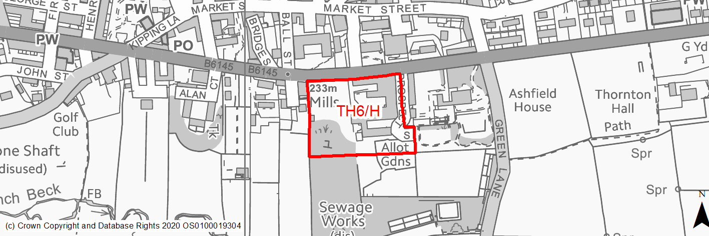
Site location
Local Growth Centre - Thornton
Ward
Thornton and Allerton Ward
Site description
Cleared land formerly accommodating the sites of Dole and Prospect Mills, which has been cleared following a fire. Site is situated in village centre, along Thornton Road. The site slopes gently to the south and is rewilding with early successional habitat.
Proposed Allocation
Housing
SHLAA referencce
TH/012
Indicative no. dwellings
50
Site area (Gross) (ha)
1.21
Ownership
Private
Delivery timescales
Developable (6-10 years)
Type (PDL/Greenfield)
PDL
Green Belt
No
Flood Zone
Flood Zone 1
Potential site access
Thornton Road using original access, good visibility.
Public Transport Accessibility
Main bus stop within 400m
Sustainability Appraisal
No significant adverse effects predicted for the site. Minor adverse effects predicted for air quality and water resources, as well as for the flood risk SA Objective due to some areas of surface water flooding risk within the site. This vacant PDL site, near the centre of Thornton, would be an opportunity to achieve biodiversity net gains and to deliver improvements on the local character. The site is within the Thornton Conservation Area and in proximity to several Grade II Listed Buildings, the setting of which would likely be improved by new development here. Residents at the site would have good access to key services, amenities and cultural spaces in the centre of Thornton, as well as jobs, and would have particularly good access to schools and health facilities.
Habitats Regulations Assessment
This site falls within 7km of the South Pennine Moors SPA/SAC. A HRA must be undertaken to ensure there are no significant effects on these protected sites. Developments within these zones must comply with Policy SP11; a SPD is being produced to provide further guidance.
Green Belt
N/A – Site not within the Green Belt.
Constraints and Opportunities
• This is a former mill site with mill pond so potential for contamination and former structures. Within Thornton Conservation Area and setting of Grade II listed houses on Thornton Road.
• 50% of site contains former Coal Mining Activities and Development High Risk Area for coal mining.
• South of the site includes trees protected by the Conservation Area, there is also potential for biodiversity - early successional habitat. Brownfield site which needs to be surveyed for priority habitat prior to allocation.
• Development of the site would have a moderate impact on the landscape.
• The site is within a Green Infrastructure Corridor.
• The site is located within the 7km buffer of the SPA/SAC.
Development considerations
• The site is a former mill which burnt down in 2016, it has laid derelict since.
• Further ecological investigations will be required as early successional habitat. Trees onsite are protected by Conservation Area status so should be retained.
• Within Thornton Conservation Area and setting of Grade II listed houses on Thornton Road, development would resolve derelict land issues but would need to enhance the CA.
• A sensitive site design, which incorporates green infrastructure will be required to mitigate any impact on the Green Infrastructure corridor and the wider landscape.
• Ground conditions will need to be investigated due to former industrial use. Existing access onto Thornton Road can be used.
Conclusion/Summary
This is a level, previously developed site, sustainably located within the settlement boundary and near to a number of local services including a primary school and open space. It would deliver an estimated 50 dwellings. It would represent efficient use of a derelict site.
(7) TH7/H - Old Road
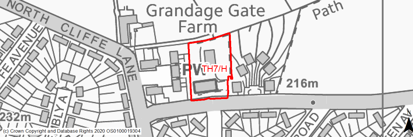
Site location
Local Growth Centre - Thornton
Ward
Thornton and Allerton Ward
Site description
Cleared levelled infill site of the Former Sacred Heart Church hall along the north of Old Road. Some foundations exist but the site is rewilding with early successional habitat. The site is bounded by residential properties to the east and west and open fields to the north.
Proposed Allocation
Housing
SHLAA referencce
TH/018
Indicative no. dwellings
13
Site area (Gross) (ha)
0.29
Ownership
Private
Delivery timescales
Developable (6-10 years)
Type (PDL/Greenfield)
PDL
Green Belt
No
Flood Zone
Flood Zone 1
Potential site access
Good existing access from Old Road.
Public Transport Accessibility
Main bus stop 300m
Sustainability Appraisal
No significant adverse effects predicted for the site. Predominantly minor adverse effects predicted for natural environment themed SA Objectives. Whilst the site is predominantly PDL, it has greened over, is open space and is adjacent to TPO protected woodland. The site is just outside the target distance of a range of key services and amenities in the centre of Thornton, such as shops. The site generally has good access to other key services and economic areas, including buses, jobs, cultural spaces and schools, with particularly good access to health facilities.
Habitats Regulations Assessment
This site falls within 7km of the South Pennine Moors SPA/SAC. A HRA must be undertaken to ensure there are no significant effects on these protected sites. Developments within these zones must comply with Policy SP11; a SPD is being produced to provide further guidance.
Green Belt
N/A – Site not within the Green Belt.
Constraints and Opportunities
• The site is located within the 7km buffer of the SPA/SAC.
• Within 50m of Grade II Listed Building.
• Sustainable location within settlement boundary.
• Previously developed land - former church.
Development considerations
• Within 50m of Listed Building but development would not impact the assets.
• Ecological surveys required as maybe early successional habitat.
• Site would need to be cleared.
Conclusion/Summary
Site contains scrubland and some evidence of former building. This is a level, previously developed site, sustainably located within the settlement boundary and near to a number of local services including a primary school and open space. It would deliver an estimated 13 dwellings. It would represent efficient use of a derelict site.
(19) TH8/HC - Thornton Road West
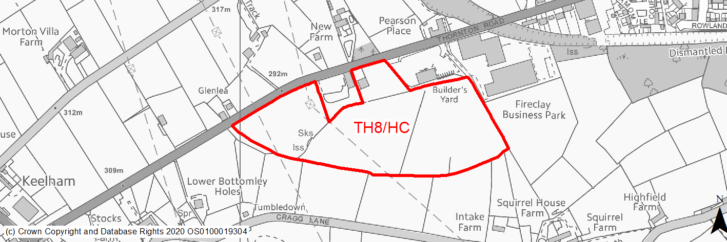
Site location
Local Growth Centre - Thornton
Ward
Thornton and Allerton Ward
Site description
Level to sloping land fronting Thornton Road.
Proposed Allocation
Housing
SHLAA referencce
TH/027
Indicative no. dwellings
250
Site area (Gross) (ha)
6.67
Ownership
Private
Delivery timescales
Developable (6-15 years)
Type (PDL/Greenfield)
Greenfield
Green Belt
No
Flood Zone
Flood Zone 1
Potential site access
The site would be accessed off Thornton Road.
Public Transport Accessibility
Public transport accessibility has been taken into account as part of the planning application process.
Sustainability Appraisal
Development at this site would be unlikely to result in a significant effect, either positive or negative, on any SA Objective.
Minor positive effects were predicted for a range of socio-economic themed SA Objectives due to the benefits of new residential development for the local economy as well as the location of the site in relation to transport links, health facilities and employment areas. However, access to both primary and secondary schools is somewhat limited due to distance, and residents may need to travel way beyond the target distance to access services and amenities.
There are no major adverse effects predicted for the site, but as a large greenfield site containing trees the development has been predicted to result in minor adverse effects on most natural environment themed SA Objectives. Additionally, the site falls within Impact Risk Zones for the South Pennine Moors SAC/SPA/SSSI, meaning consultation with Natural England would be required for a development of 50 dwellings or more to ensure no adverse effects on the SAC/SPA/SSSI.
Habitats Regulations Assessment
The majority of this site falls within 2.5km of the South Pennine Moors SPA/SAC a HRA must be undertaken to ensure there are no significant effects on these protected sites in terms of impact on supporting habitat which might be functionally linked to the SPA and recreational pressures. Developments within these zones must comply with Policy SP11; an SPD is being produced to provide further guidance.
Green Belt
N/A – Site not within the Green Belt.
Constraints and Opportunities
• Relevant constraints and opportunities have been considered as part of the planning application process.
Development considerations
• Relevant development considerations have been taken into account as part of the planning application process.
Conclusion/Summary
This site has outline planning permission for 250 dwellings (17/06423/MAO approved 21.08.19).
(12) TH9/H - Hill Top Road, Close Head Drive
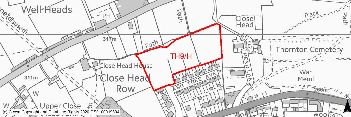
Site location
Local Growth Centre - Thornton
Ward
Thornton and Allerton Ward
Site description
Open agricultural field to the west of Thornton. A former farmstead was in centre of site and some remains can be seen otherwise dry stone walls bisect the site. Access is available from the adjacent estate via field access at Close Head Drive. There are agricultural fields surrounding the site aside from the south where there is a residential development. The site slopes north to south and is located on a hillside location with far ranging views across the valley.
Proposed Allocation
Housing
SHLAA referencce
TH/029
Indicative no. dwellings
50
Site area (Gross) (ha)
1.85
Ownership
Private
Delivery timescales
Developable (6-10 years)
Type (PDL/Greenfield)
Greenfield
Green Belt
Yes
Flood Zone
Flood Zone 1
Potential site access
Existing access off Ashtree Avenue - field access may need improvements but road reasonably wide.
Public Transport Accessibility
Bus stop within 400m
Sustainability Appraisal
There are unlikely to be any significant effects, either positive or negative, on any SA Objective arising as a result of development at this site.
Minor positive effects were predicted for a range of socio-economic themed SA Objectives due to the benefits of new residential development for the local economy, as well as the location of the site in relation to transport links and health facilities, however access to both primary and secondary schools is somewhat limited due to the distances involved. Residents may also find they need to travel beyond the target distance to access services and amenities.
Minor adverse effects were predicted for a range of natural environment themed SA Objectives, primarily as a result of the impacts of new development on a 100% greenfield and Green Belt site containing trees and with adjacent TPO woodland.
Habitats Regulations Assessment
This site falls within 2.5km of the South Pennine Moors SPA/SAC a HRA must be undertaken to ensure there are no significant effects on these protected sites in terms of impact on supporting habitat which might be functionally linked to the SPA and recreational pressures. Developments within these zones must comply with Policy SP11; an SPD is being produced to provide further guidance.
Green Belt
See individual Green Belt site assessment in the accompanying report.
Constraints and Opportunities
• The site is currently designated as Green Belt.
• A large water main diagonally crosses the east of the site.
• The Bronte Way public footpath, which is a draw for tourists and has high cultural significance, runs along north of site.
• Development of the site would have a high impact on the landscape.
• The site is within a Green Infrastructure Corridor.
• The site is located within the 7km buffer of the SPA/SAC.
• Existing field access off Ashtree Avenue.
• Site is in a sustainable location, adjacent the existing settlement.
Development considerations
• Existing access off Ashtree Avenue may need improvements but road reasonably wide.
• A sensitive site design, which incorporates green infrastructure, will be required to mitigate any impact on the Bronte Way, Green Infrastructure corridor and the wider landscape.
• Provision of compensatory improvements to the surrounding Green Belt will be required and may include enhancement of the existing rights of way network.
• Drainage infrastructure – due to the site topography and existing constraints additional detailed work should be undertaken in a comprehensive manner across the proposed development sites to the west of Thornton on planning drainage routes, connections and new drainage infrastructure provision.
Conclusion/Summary
This is a sloping greenfield site, in a sustainable location adjacent the settlement boundary, close to local services and facilities. It would deliver an estimated 50 dwellings and enhanced open space provision, it will benefit from cohesive, high quality design principals. Existing access to the field can be adapted to residential standards.
(13) TH10/H - Hill Top Road, near Ring O' Bells
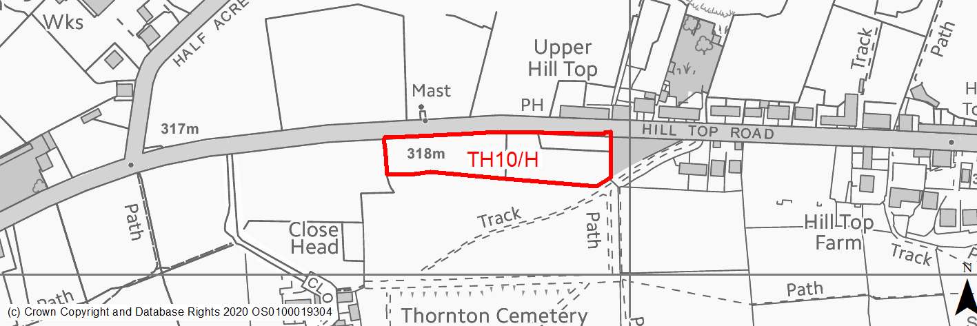
Site location
Local Growth Centre - Thornton
Ward
Thornton and Allerton Ward
Site description
Moderately sloping agricultural field which includes a hard standing area, used by the pub over the road as overflow parking. The site is a narrow open field located between Hill Top Road and Thornton Cemetery. The trees from Thornton Cemetery could provide some screening for the site.
Proposed Allocation
Housing
SHLAA referencce
TH/033A
Indicative no. dwellings
27
Site area (Gross) (ha)
0.86
Ownership
Council
Delivery timescales
Developable (6-10 years)
Type (PDL/Greenfield)
Greenfield
Green Belt
No
Flood Zone
Flood Zone 1
Potential site access
Existing access for pub overflow car park onto Hill Top Lane.
Public Transport Accessibility
Bus stop 500m away but limited service. Main route 650m.
Sustainability Appraisal
Development at this site would be unlikely to result in a significant effect, either positive or negative, on any SA Objective.
Minor positive effects were predicted for a range of socio-economic themed SA Objectives due to the benefits of new residential development for the local economy, as well as the location of the site in relation to transport links and health and education facilities.
Minor adverse effects were predicted for a range of natural environment themed SA Objectives, primarily as a result of the impacts of new development on a 100% greenfield site containing trees. There are thirteen Grade II Listed Buildings within 375m of the site, the nearest adjoining the north-eastern corner, the settings of which could be adversely affected by the development.
Habitats Regulations Assessment
This site falls within 7km of the South Pennine Moors SPA/SAC. A HRA must be undertaken to ensure there are no significant effects on these protected sites. Developments within these zones must comply with Policy SP11; a SPD is being produced to provide further guidance.
Green Belt
N/A – Site not within the Green Belt.
Constraints and Opportunities
• The site is within a Green Infrastructure Corridor.
• Development of the site would have a moderate impact on the landscape.
• The site is located within the 7km buffer of the SPA/SAC.
• Adjacent to Grade II listed building.
• Public footpath along eastern boundary.
• Site has poor accessibility due to poor bus services, steep topography and distance to some local services.
Development considerations
• A sensitive site design, which incorporates green infrastructure, will be required to mitigate any impact on the Green Infrastructure corridor and the wider landscape, the site may be screened by trees from Thornton Cemetery.
• Attention to local distinctiveness and built form would be required to mitigate the affect on the setting of Listed Buildings on Hill Top Road.
• No current connection to drainage which would have to be taken from the south. Drainage infrastructure – due to the site topography and existing constraints additional detailed work should be undertaken in a comprehensive manner across the proposed development sites to the west of Thornton on planning drainage routes, connections and new drainage infrastructure provision.
• Highways infrastructure – development should avoid excessive vehicle load on Hill Top Road and creating additional traffic flow into West Thornton where possible. The junction of Hill Top Road and Wicken Lane is substandard. The level of development proposed in total will create additional vehicle movement and potential pinch points particularly within the village. Additional detailed work through the strategic transport model will inform the further development of the local plan and identify whether the growth proposed will be within a tolerable range of impacts on the highways and any mitigation measures which may be necessary.
• This site forms part of a wider Master plan area for West Thornton which must be considered cohesively.
Conclusion/Summary
The site currently consist of open space and an overfill car park for the adjacent pub along Hill Top Road, suitable for approximately 27 dwellings. It suffers from poor accessibility and distance to local services by sustainable means. Landscape and heritage concerns could be mitigated through appropriate design. Vehicular and pedestrian access is available off Hill Top Road, although a new junction will be required.
(16) TH11/H - South of Hill Top Road and East of Close Head Lane
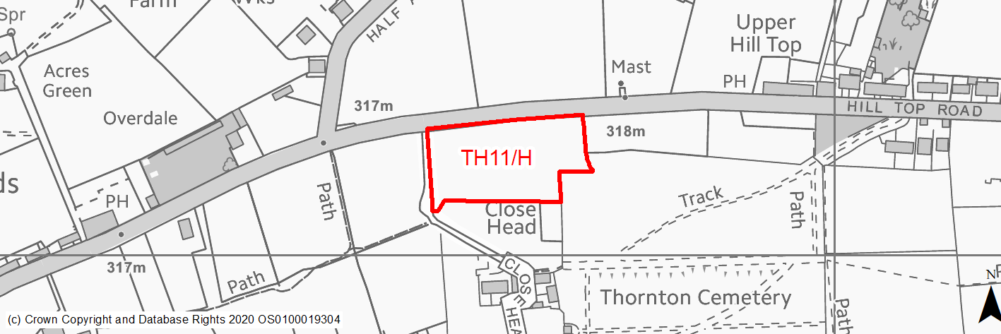
Site location
Local Growth Centre - Thornton
Ward
Thornton and Allerton Ward
Site description
Moderately sloping agricultural field, bounded by dry stone walls to the south of Hill Top Road. The site is mainly surrounded by agricultural fields and isolated dwellings. It is somewhat detached from the main settlement.
Proposed Allocation
Housing
SHLAA referencce
TH/033B
Indicative no. dwellings
30
Site area (Gross) (ha)
0.96
Ownership
Council
Delivery timescales
Developable (6-10 years)
Type (PDL/Greenfield)
Greenfield
Green Belt
Yes
Flood Zone
Flood Zone 1
Potential site access
Existing access for pub overflow car park onto Hill Top Lane.
Public Transport Accessibility
Bus stop 500m away but limited service. Main route 650m.
Sustainability Appraisal
Development at this site would be unlikely to result in a significant effect, either positive or negative, on any SA Objective.
Minor positive effects were predicted for a range of socio-economic themed SA Objectives due to the benefits of new residential development for the local economy, as well as the location of the site in relation to transport links and health and education facilities.
Minor adverse effects were predicted for a range of natural environment themed SA Objectives, primarily as a result of the impacts of new development on a 100% greenfield site containing trees. There are thirteen Grade II Listed Buildings within 375m of the site, the nearest adjoining the north-eastern corner, the settings of which could be adversely affected by the development.
Habitats Regulations Assessment
This site falls within 7km of the South Pennine Moors SPA/SAC. A HRA must be undertaken to ensure there are no significant effects on these protected sites. Developments within these zones must comply with Policy SP11; a SPD is being produced to provide further guidance.
Green Belt
See individual Green Belt site assessment in the accompanying report.
Constraints and Opportunities
• The site is currently designated as Green Belt.
• The Bronte Way public footpath, which is a draw for tourists and has high cultural significance, runs along the south of the site.
• Development of the site would have a moderate impact on the landscape.
• The site is within a Green Infrastructure Corridor.
• The site is located within the 7km buffer of the SPA/SAC.
• Moderate slope north to south.
• Site has poor accessibility due to poor bus services, steep topography and distance to some local services.
Development considerations
• Existing access in centre of field on Hill Top Road but new junction would be needed.
• Highways infrastructure – development should avoid excessive vehicle load on Hill Top Road and creating additional traffic flow into West Thornton where possible. The junction of Hill Top Road and Wicken Lane is substandard. The level of development proposed in total will create additional vehicle movement and potential pinch points particularly within the village. Additional detailed work through the strategic transport model will inform the further development of the local plan and identify whether the growth proposed will be within a tolerable range of impacts on the highways and any mitigation measures which may be necessary.
• Provision of compensatory improvements to the surrounding Green Belt will be required and may include enhancement of the existing rights of way network.
• No current connection to drainage which would have to be taken from the south. Drainage infrastructure – due to the site topography and existing constraints additional detailed work should be undertaken in a comprehensive manner across the proposed development sites to the west of Thornton on planning drainage routes, connections and new drainage infrastructure provision.
Conclusion/Summary
Green belt site which is detached from the settlement. Thee are long ranging views out of the site. Due to its location in the green belt, detachment from settlement and drainage issues, this site is a reserve site as there are preferable options within the settlement.