
Draft Bradford District Local Plan - Preferred Options (Regulation 18) February 2021
Bradford North East
Introduction
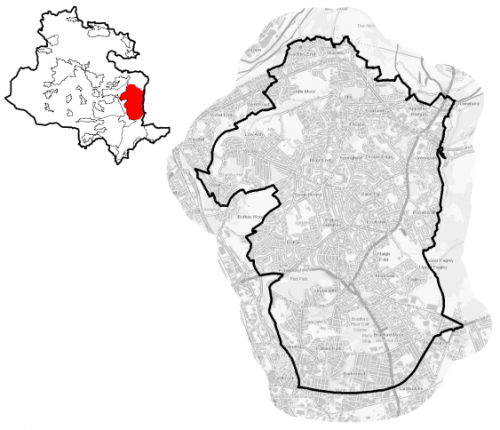
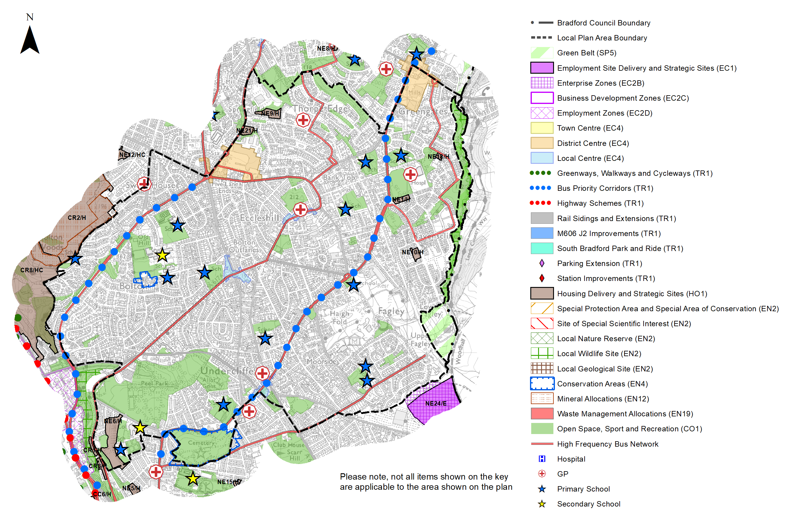
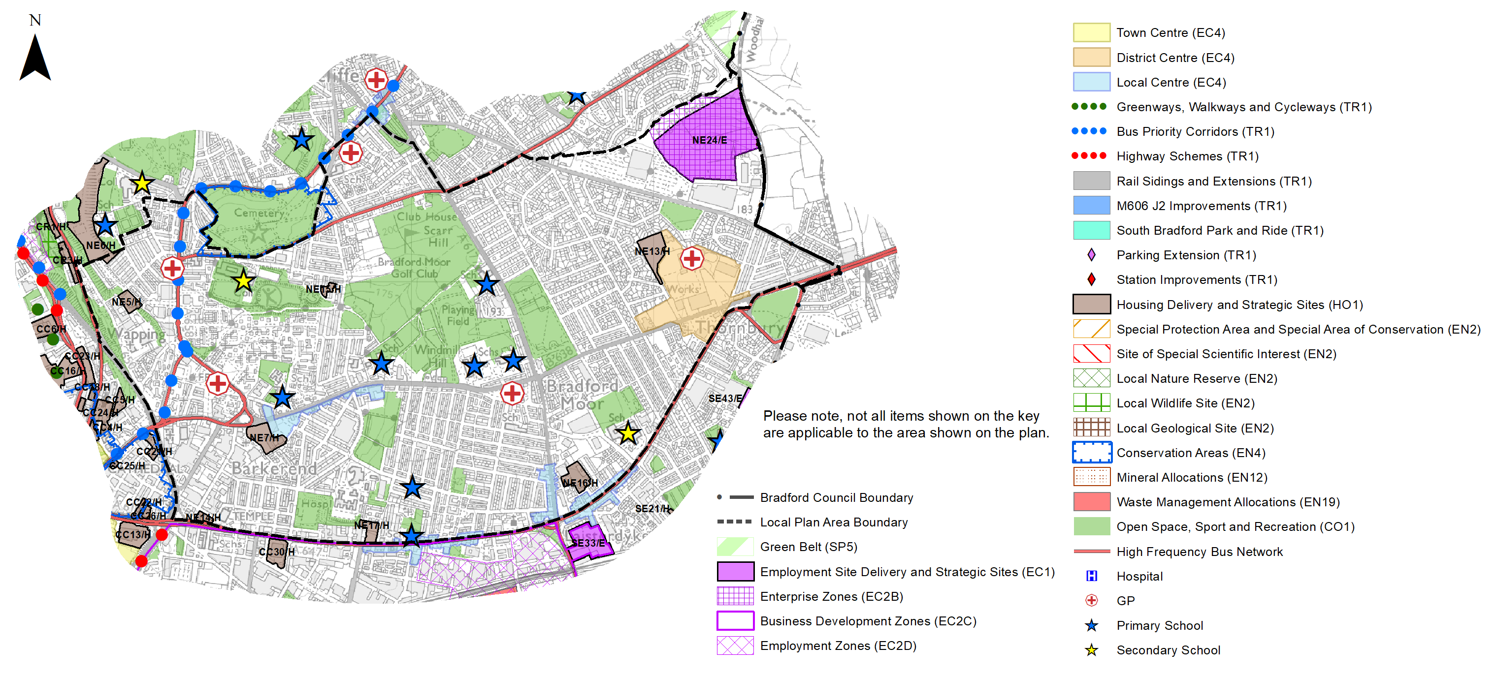
5.2.1 The Local Plan settlement hierarchy identifies Bradford North East as one of four quadrant areas within the wider Regional City of Bradford. It is broadly defined by Leeds Road to the south and the fringes of the Canal Road area to the west, extending northwards to Thackley woods and the Leeds LiverpooL Canal and the District boundary with Leeds to the east. It covers an area of 1,650 hectares and is primarily residential in character with strong commuter and access connections to Bradford and Leeds City Centres.
5.2.2 Bradford North East includes the wards of Idle and Thackley, the southern part of Windhill and Wrose, Eccleshill, Bolton and Undercliffe (east of Wapping Road), Bowling and Barkerend and Bradford Moor.
Figure 1: Location Plan
5.2.3 The area is a densely developed and populated urban environment with a total resident population of 92,360. Further characteristics of Bradford North East show:
- It has a slightly higher percentage of children living in poverty and a higher percentage of children aged than 0-15 (25.5%) than West Yorkshire (20.6%)
- Over half the population of the area live in neighbourhoods which fall in the most deprived 20% in the Country. Of particular note are the indices which relate to higher education, income, crime and living environment
- It has a lower proportion of people that identify themselves as white British ethnicity (59.8%) compared to the rest of West Yorkshire (78.4%).
Planning for Prosperity
5.2.4 The Local Plan settlement hierarchy under Policy SP3 identifies the Regional City as the key focus for housing, employment, shopping, leisure, education, health and cultural activities and facilities. Growth in the North East quadrant will transform the economic, environmental, physical and social conditions of local communities and support the long term regeneration of both the regional city and wider District.
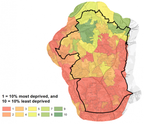
5.2.5 Bradford North East is characterised by pockets of deprivation within all wards. Biases include health, income, employment and education deprivation. A total of 51,612 residents (55.9%) are living within the 20% most deprived areas in England by Indices of Multiple Deprivation (IMD) 2019. Figure 2 shows the overall picture of deprivation in Bradford North East.
Figure 2: Index of Multiple Deprivation – Bradford North East
Economy and Employment
5.2.6 Economic activity rates are 67.1% which slightly lower than the West Yorkshire average of 68.5%. district and regional average. Annual average household income is £35,196 lower than both the District average of £36,871 and the regional average of £38,499. The largest workforce jobs are in education, professional, scientific and technical services and health which account for 36.1% of all employment in the area.
5.2.7 The main employment areas are located to the south of Leeds Road and therefore in Bradford South East area but there are pockets of employment development, most notably in Idle and Greengates, east of the Shipley Airedale Road and south of Barkerend Road and at Gain Lane where Morrisons have their headquarters and there is a major bakery. Land at Gain Lane and Woodhall Road is identified within the employment allocations as a key site and established Enterprise Zone.
5.2.8 Policy SP6 sets a District target for the provision of at least 72ha of open market employment land - use classes B2, B8 and E (formerly B1 type uses). Sites for new employment are identified on the Policies Map.
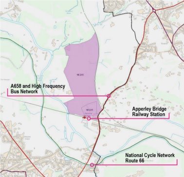
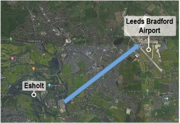
5.2.9 Bradford North East and beyond to Esholt is well-connected in relation to rail at Apperley Bridge and road connection through A658 to Leeds Bradford Airport and the wider West Leeds area (Leeds Road / A65). Although technically not within the Bradford North East boundary, the local plan has identified strategic scale growth opportunities within the Esholt area to provide new employment space for existing businesses looking to expand and inward investment opportunities.
5.2.10 It is noted in the employment section of the plan that the District has a limited range of medium and large scale employment sites and land at Esholt provides one of the few large scale / strategic scale development opportunities with the Bradford District. More specifically, it is proposed to allocate two sites within the Esholt area for employment delivery over the lifespan of the local plan:
- NE22E – Walkhill Farm, Apperley Lane – 4.94ha
- NE23/E – Apperley Bridge / Esholt (Former Water Treatment Works), Esholt – 26.61ha
5.2.11 The area covered by the former filter beds is brownfield and of significant scale, within a sensitive wider Green Belt and landscape setting and will require a comprehensive approach to site master-planning and delivery. It is seen as a key opportunity site to deliver high quality employment space and support Bradford's contribution to building the green economy.
5.2.12 Land to the south of NE23/E (NE22/E) has also been identified as a complementary gateway employment site to deliver a smaller range of employment units within a sensitive Green Belt location.
5.2.13 The Gain Lane site (NE24/E) and proposed employment land at Esholt are identified in table A, on the Policies Map and within the site pro formas. A specific local strategy map with additional detail is also provided for Esholt later in this document.
Retail
5.2.14 All retail centres have been subject to a review as part of the Retail and Leisure Study (2019). The original study was completed in 2012. he City Centre is the main focus for retail and service provision for the District followed by the Principal Towns, District Centres and Local Centres.
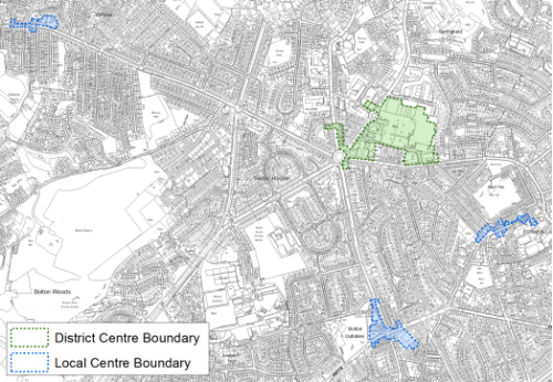
5.2.15 The Local Plan identifies the Five Lane Ends District Centre, the Greengates District Centre and the Thornbury District Centre as the main focusses for convenience retail and limited comparison retail and a range of non-retail services such as banks, building societies, restaurants, cafes and other local facilities in Bradford North East. The extent of the District centre boundaries are shown on the Policies Map and figures 3a to 3c below.
5.2.16 Five Lane Ends is considered to have reasonable level of activity and is accessible for pedestrians, cars and public transport. Despite some changes in the centre since 2012, including vacancy it is considered healthy but would benefit from some updating.
5.2.17 Greengates District Centre has a strong convenience offer with more limited comparison offer, which act as a significant attractor and are based in significant sized units. Other services are located in smaller units which complement the main sheds on Harrogate Road. The study commented that the centre had a strong footfall from people arriving in cars and by foot. One negative indicator identified was the lack of suitable crossing facilities for pedestrians and heavy traffic at the main junction. This will be rectified by the road improvement scheme.
5.2.18 Thornbury District Centre has grown significantly since 2012 with the construction of the Bradford Plaza and permissions in place for additional new convenience. The centre is considered to be accessible and provides ample parking for visitors. The Retail and Leisure Study however commented that whilst busy, the mix of uses is limited and the overall environment would benefit by new soft landscaping and tree planting.
5.2.19 The Local Plan also identifies eight designated Local Centres within Bradford North East including;
- Barkerend Rd
- Bolton junction
- Eccleshill
- Idle
- Laisterdyke – which falls across both North East and South East
- Leeds Rd- which falls across both North East and South East
- Undercliffe
- Wrose
The boundaries for these areas are shown on the policies map and below. These centres cater for general everyday shopping needs to minimise the need to travel.
Figure 3a: Greengates District Centre and Idle Local Centre
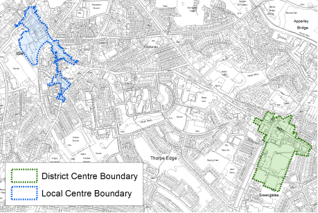
Figure 3b: Thornbury District Centre and Barkerend Road, Laisterdyke, Leeds Road and Undercliffe Local Centres
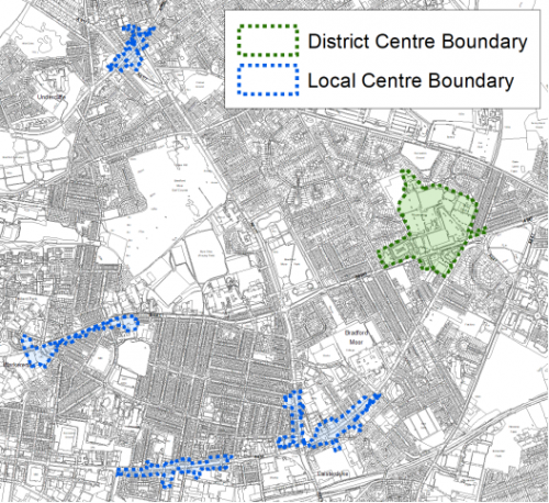
Figure 3c: Five Lane Ends District Centre and Bolton Junction, Eccleshill and Wrose Local Centres
5.2.20 The Retail and Leisure study commented that the Barkerend Road Local Centre contains a good variety of uses but is tired and would benefit from improvement. It also commented that the vacant site of Barkerend Mills is a detractor. The redevelopment of this site for residential use is identified as a proposal in this Plan.
5.2.21 Bolton Junction Local Centre comprises a variety of uses but has low footfall. The study recommended its retention as a local centre but commented that it would benefit from investments in elevation treatments and improved landscaping.
5.2.22 The retail and leisure study commented that Eccleshill Local Centre has a reasonable variety of uses but suffers from lack of vitality during the daytime as many of the units are takeaway units with shutters and not open until evening. It also noted the lack of trees and landscaping.
5.2.23 Idle Local Centre is generally well maintained, with some vacancy predominantly pubs. The topography of the centre has been identified as a potential deterrent but the food offer has improved with the opening of the Aldi supermarket on the former Dunnes store.
5.2.24 Laisterdyke Local Centre sites at the junction of Leeds Rd and Killinghall Rd. The sub area boundary is Leeds Rd and therefore part of this local centre also sits in Bradford South East and serves residents in this adjacent sub area. The retail and leisure study comments that, this is one of the largest local centres and has good service provision. Vacancy of units has reduced since the last study and shopfronts were noted to be in good order.
5.2.25 The Leeds Road local centre is located on both sides of Leeds Rd and provides facilities to residents in both Bradford North East and Bradford South East as Leeds Road forms the settlement boundary. Leeds Road is considered to be a healthy and attractive local centre with a good mix of uses and is well used and generally busy.
5.2.26 Undercliffe Local Centre straddles the Otley Road/Killinghall Rd cross roads. The study noted that vacancy levels were higher than the national average and had increased since the 2012 study. It also noted that a number of the shopfronts were dated and poorly maintained and potentially contribute to the low levels of footfall.
5.2.27 Wrose Local centre is one of the smallest and anchored by a newly built Co-op store. There were no issues of environmental improvement identified other than in opening times of some of the units.
5.2.28 Some of the key challenges identified for the centres within Bradford North East in the Retail and Leisure Study (2019) include the continual monitoring of vacancy rates and improvements to the environmental quality and appearance of some centres.
Transport and Access
5.2.29 Lying at the northern end of the Bradford District, North East Bradford benefits from a range of excellent road links which provide bus travel within the wider area into the City Centre and out towards Leeds. It also benefits from the Apperley Bridge railway station which provides a stop on the Airedale line and links North Yorkshire, access into the City and out to the east to Leeds and beyond.
5.2.30 The North East area is served by several high-frequency (every 15 to 20 minutes) bus routes. As 31% of all households have no car the value of public transport and good walkable local services are therefore of great importance.
5.2.31 Parts of the sub area are within an area of concern for air quality and have been identified within the proposed Clean Air Zone (CAZ). Of particular concern is the area around the Shipley Airedale and Barkerend Road junction and this is an Air Quality Management Area. Other areas of concern are the Harrogate Rd/New Line junction and Harrogate Rd/ Killinghall Rd junction.
5.2.32 Ofcom digital connectivity data indicates that, average broadband download speeds in Bradford North East are just over 50 mega-bites per second, above the West Yorkshire average, whilst there are 314 premises where speeds are below the Universal Service Obligation (USO)[1].
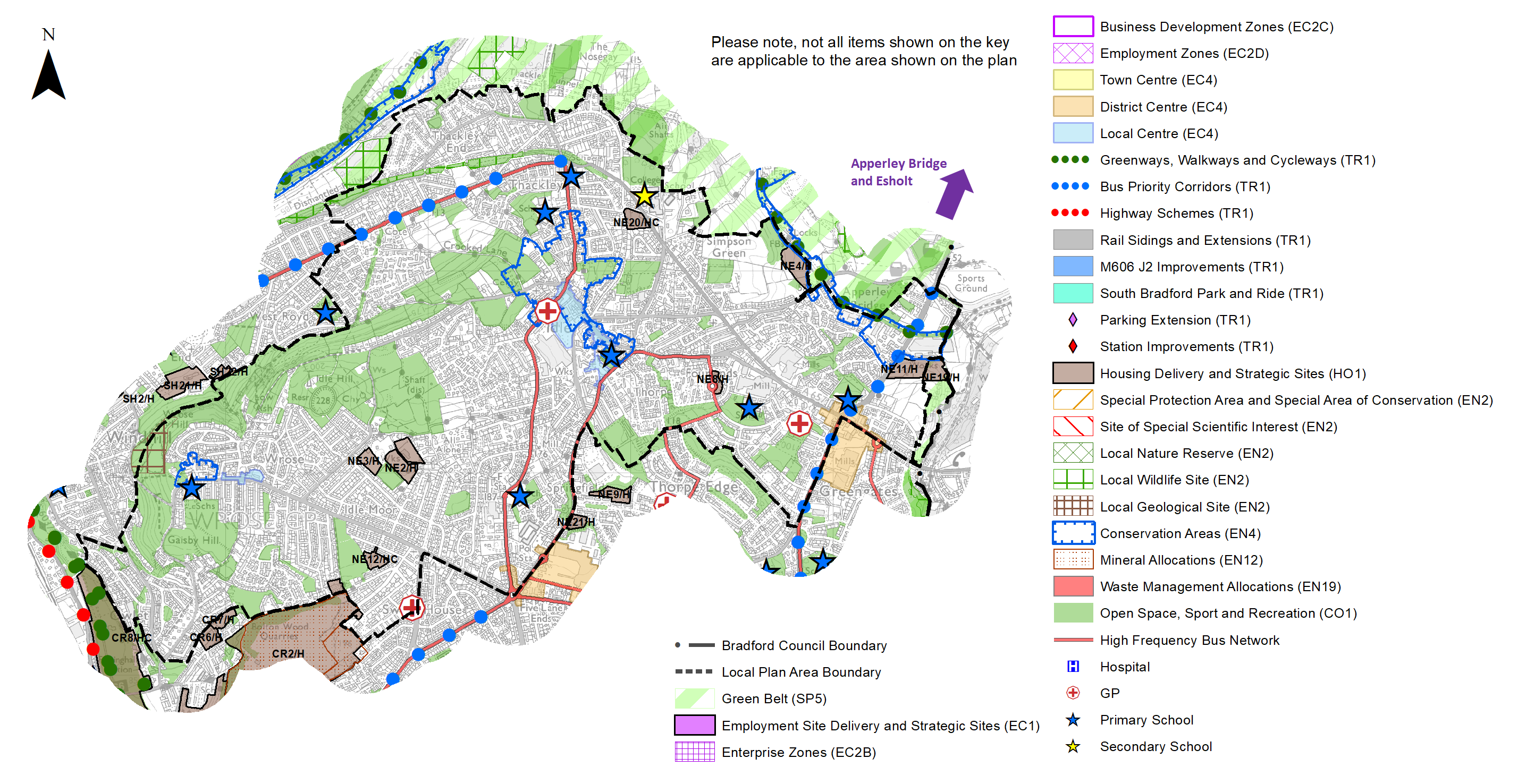
5.2.33 Strategic transport infrastructure projects to be delivered within the plan period and protected routes are set out on the Policies Map. Key initiatives within Bradford North East are detailed in Table 1 below.
Table 1: Bradford North East Transport Projects
|
Policies Map Ref. |
Project Name |
Local Area |
|
TR1.C.2 |
Bus Priority Corridors (New Otley Road/ Harrogate Road and Leeds Road) |
Barkerend, Undercliffe and Eccleshill & Wrose, Thackley and Idle |
|
TR1.9.2 |
Apperley Bridge Parking Extension |
Wrose, Thackley and Idle |
Planning for Homes
5.2.34 Bradford North East has 33,601 dwellings, the majority of which are semi-detached. The proportion of detached homes is around 6% lower than the sub regional average. 66.3% of homes are owner occupied and the average house price across the area is £147,074 which is lower than the sub regional average of £183,194. Nearly half of the housing stock in the area was built before 1945, with 11.9% built since 2000. This is less than either the England or West Yorkshire averages. Figure 4 below provides further information.
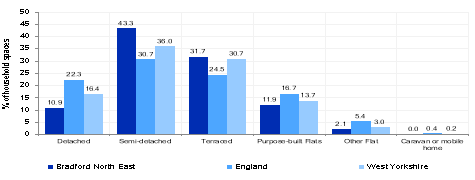
 Figure 4: Bradford North East – Dwelling Type and age Breakdown
5.2.35 The total affordability ratio between house prices and annual earnings which is usually used as a proxy for number of years' worth of earnings required for a house deposit is 2.85 years compared to a West Yorkshire average of 2.96, meaning that the area is theoretically more accessible for first time buyers.
5.2.36 Delivering new housing is a key part of the overall development strategy for the District. The Local Plan seeks to support the creation of sustainable communities in Bradford North East through the regeneration of existing urban areas, particularly supporting the economic, environmental, physical and social transformation of key areas including: Barkerend and Bradford Moor and the former Council estates of Thorpe Edge and Ravenscliffe, through the reuse of brownfield land and buildings. It will ensure that the housing needs and aspirations of local people can be met, by market and affordable housing.
5.2.37 Policy SP8 sets out a requirement of 1,850 dwellings that will be delivered within Bradford North East within the plan period. These will be delivered through a mix of committed sites that are either under construction or have planning permission (but have not yet commenced), as well as new site allocations. These new homes will be delivered by a mix of sites including existing capacity within the urban area together with a small contribution from the Green Belt in sustainable locations.
Table 2: Bradford North East - Summary of Housing Requirement and Supply
|
Housing Target |
1,850 units |
|
Carried Forward Commitments |
1,319 |
|
Commitments Discounted by 10% |
1,187 |
|
Remaining Allocation Requirement |
663 |
|
Identified Allocations |
779 |
|
Allocations Discounted by 10% |
701 |
|
Total Supply Contribution from Allocations |
701 |
5.2.38 Once the commitments are discounted and removed from the supply this leaves a residual allocation requirement of 663 units. The evaluated total supply of housing units from preferred allocation sites equates to 779 which in turn is discounted by 10% for non- implementation leaving a final allocation contribution of around 701 across all sites to meet the remaining requirement. The Council will be supportive of additional proposals for new homes on additional small sites, particularly those that provide a redevelopment opportunity to bring forward land which has been previously used. Support will also be provided to developers who wish to redevelop larger sites and/or buildings for new homes not currently identified, subject to all relevant policies in the Local Plan.
5.2.39 Bradford North East's allocation mix of 21 sites includes, 8 sites which are brownfield which comprising cleared land and some buildings, 2 are missed (brownfield/greenfield) and 11 are greenfield. Ten of the greenfield sites lie within the urban area and 1 is in the current Green Belt. The new Local Plan preferred site allocations for residential allocations to meet the Bradford North East housing requirement are set out in Table B and identified on the Policies Map and the Site Pro-formas together with the local strategies map for each plan area. Development of site allocations should be in accordance with specified development guidelines and approximate site provision figures and all other relevant policies of this Local Plan. In delivering the target for new homes in Bradford North East it has been necessary to make some changes to the adopted green belt. Policy SP5 sets out The Councils approach and justification for green belt releases to accommodate new development and lists the sites proposed for allocation which current lie within or partly within the green belt
Planning for Places and Communities
Green Belt, Natural Landscape and Historic Character
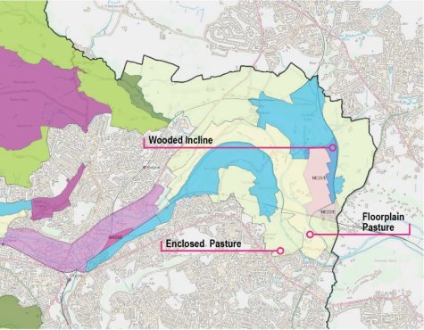
5.2.40 Bradford North East is characterised by densely developed urban landscape divided by established parks and less formal urban greenspaces out to rural landscape to the east and north. The land to the north lies within the Bradford Green Belt and the Esholt Landscape Character Area. The prevailing landscape in this area is characterised by wooded incline, enclosed pasture and floodplain pasture. The wooded incline has been assessed as having strong character with strong historic continuity. It continues that only small scale development should be considered. The enclosed pasture and floodplain pasture was in contrast was assessed as having strong character but in declining and poor condition and sensitive to further change.
5.2.41 The Bradford North East area contains 434 listed building, 5 of which are grade II* and five Conservation Areas- The Leeds Liverpool Canal, Idle village, Wrose village, Hodgson Fold and Undercliffe Cemetery which is also a Historic Park and Garden as is Peel Park. Buck Wood contains a scheduled ancient monument comprising carved rocks. Idle conservation area and buildings fronting Feversham Street are on the Heritage at Risk register
Green Infrastructure, Ecology, Open Space and Flood Risk
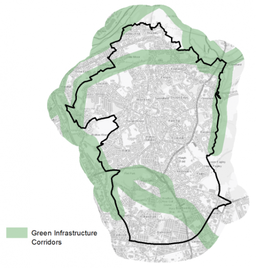
5.2.42 The area has a range of corridors and spaces that contribute towards its Green and Blue Infrastructure networks. These corridors and open areas contribute towards the areas Green and Blue Infrastructure networks that form part of the District's Green Infrastructure network and should be protected and enhanced. These areas are multi-functional in nature and help to deliver benefits for biodiversity, reduce flood risk, provide public rights of way, and areas of open space. New developments should identify the opportunities to connect into these networks by enhancing natural features that exist on-site and improving the links between sites. The key corridors in the area are the waterways and woodlands to the north of the settlement around Thackley and Apperley Bridge and the District boundary with Leeds. Within the urban area, improvements that better link the Boars Well nature reserve with Peel Park and Undercliffe cemetery and Myra Shay are under consideration. These are identified below in Figure 5.
Figure 5: Green Infrastructure Corridors
5.2.43 The main areas of note for wildlife are the woodlands to the north of the settlement including Thackley Woods and Buck Wood. Additional assets for wildlife are parts of Peel Park, Undercliffe Cemetery and Myra Shay
5.2.44 There are 241 sites identified as open space within Bradford North East covering an area of around 320.06ha. The key areas of open space are; Peel Park, Myra Shay and Eccleshill and Idle Recreation Grounds. The Open Space Assessment (2019) however identifies that there is a significant deficit of open space in this settlement overall and with concentrations in some areas such as Bradford Moor and very low provision in places like Fagley, although new amenity space is to be provided as part of new development in this location. The highest areas of deficiency are in parks and gardens, certain outdoor sports and natural greenspaces. Figure 6 provides an illustrative overview of the area's open spaces.
Figure 6: Bradford North East - Open Space Overview 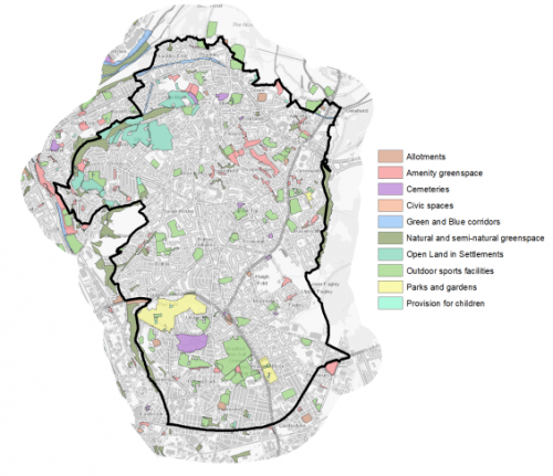
5.2.45 The River Aire valley to the north of Thackley is identified as being in Flood Zone 3b and to a larger scale Flood Zone 2. Wetland habitat is identified at the ponds in Peel Park and Bradford Moor Park with some occasional flooding connected with these assets
Community Infrastructure – Education, Health and Utilities
5.2.46 Bradford North East has a wide range of community facilities to meet the day to day needs of its local residents. These facilities range from schools, hospitals, GP surgeries through to post offices, places of worship, community halls/centres, playgrounds, a library and various sporting facilities.
5.2.47 The area is served by 27 primary schools which have the capacity to accommodate 10,518 pupils. Most schools are at capacity although some schools have been experiencing oversubscription issue. There are 6 secondary schools (Immanuel College, Hanson Academy, Feversham Academy, Carton Bolling, Laisterdyke Leadership Academy and the newly established Eden Boys' Leadership Academy). These schools (excl. Eden Boys' Leadership Academy) have a combined capacity of accommodating 6,746 pupils, but are currently undersubscribed with 386 available places. However, demand for places varies from school to school. Currently Immanuel College and Feversham Academy are the two oversubscribed secondary schools within Bradford North East.
5.2.48 Pupils attainment levels at Key Stage 4 (GCSE) is below the West Yorkshire and national (England) average scores – 331.6 compared to 353.5 and 366.3 respectively. Participation into higher education at 18 is also lower than the national average.
5.2.49 Average life expectancy at birth for Bradford North East residents lies slightly lower than sub regional and national averages with the most common causes of death being heart and lung diseases. Bradford North East has a number of NHS registered healthcare facilities within the area. There are 13 GP surgeries/health centres. Secondary healthcare is provided at St Luke's Hospital in Little Horton and at Bradford Royal Infirmary which lie in Bradford South West and North West respectively. Figure 7 shows the location of local schools and medical facilities.
5.2.50 When planning for the long-term development of Bradford North East, it is vital that new development is supported by the appropriate infrastructure. The capacity, quality and accessibility of services and facilities are all key components in ensuring people can enjoy living, working and visiting the area. The council will continue work with key infrastructure providers and others including the Local Education Authority, Clinical Commissioning Group and utilities providers to determine the impacts of future growth and development on local infrastructure capacity and provision. Further infrastructure details will be published through the Local Infrastructure Plan and as part of the Regulation 19 stage of the local plan.
Figure 7: Schools & Medical Facilities in Bradford North East 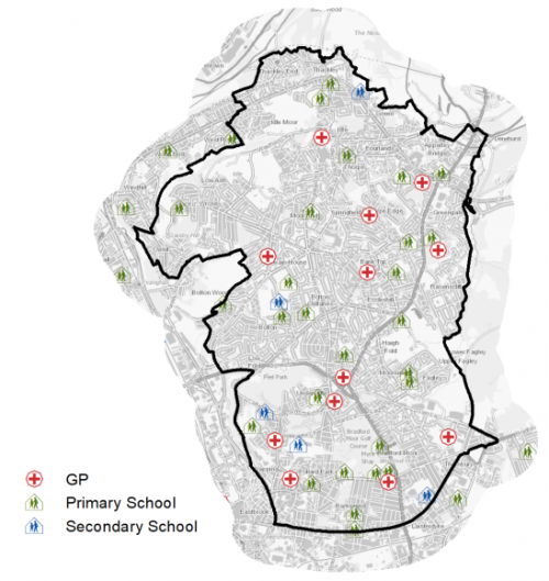
Local Area Strategies and Plans
Bradford North East Local Areas
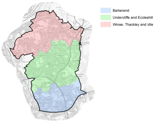
5.2.51 The Bradford North East sub-area has been broken down into 3 defined local areas with supporting spatial strategies; these are referred to as: Wrose, Thackley and Idle; Undercliffe and Eccleshill and Barkerend. These local areas are set out in figure 8 below. Each spatial strategy provides an overview of the local area and sets out the preferred allocations for housing and employment sites.
Figure 8: Bradford North East Local Plan Areas
Local Area Strategy and Plan- Wrose, Thackley and Idle |
|
|
The key elements of the local area strategy for Wrose, Thackley and Idle include: • Modest additional housing growth with 8 new sites identified for further growth capable of accommodating 278 homes. Six of these sites are greenfield, one is brownfield and one is mixed. One site is a location in the current green belt. • Sustainable development which takes advantage of existing local services including at the Greengates District centre, other local centres and public transport. • New employment sites identified on the former Esholt water treatment works which will provide local employment opportunities with good access to the railway station, supporting the economic transformation of Bradford North East • Road improvements which will facilitate improvements to the public realm • Retaining and improving the quality of open spaces in the area and support for the creation of new natural and formal open spaces together with improved connections between open areas • Integration of safe and active travel routes (cycling and walking) through neighbourhoods, to services and facilities connected to new employment sites and reduce the impact of traffic and pollution on residential communities Local Area Strategy and Plan - Undercliffe and Eccleshill
The key elements of the local area strategy for Undercliffe and Ecceshill include: • Delivering development on 6 new housing sites and which will provide for 173 homes • Support for the vitality and viability of the Five Lane Ends and Greengates District Centres and other Local Centres as key locations for local communities • Support for further windfall and infill development for new homes and business particularly if brownfield sites and buildings • Improved connectivity and integration of safe active travel routes (cycling and walking) through neighbourhoods to local services • Support for opportunities which create and enhance open spaces such as natural amenity greenspace |
|
|
Local Area Strategy and Plan - Barkerend |
|
|
The key elements of the local area strategy for Barkerend include:
|
|
|
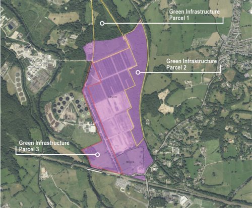
Local Area Strategy and Plan - Apperley Bridge/Esholt (Former Filter Beds – Waste Water Treatment Works) Strategic Employment Area (Sites NE22/E and NE23/E) |
|
|
Introduction Site NE23/E combined with NE22/E provides a unique strategic employment area (defined currently as Apperley Bridge Strategic Employment Area) for the delivery of premium quality employment space within an attractive valley landscape location. The site is identified to meet over 30% of the District's employment land need during the plan period and has been identified as an emerging Spatial Priority Area within the wider West Yorkshire economic strategy context. It is situated within close proximity to Leeds Bradford Airport and wider rail and road connections. The site is subject to an ongoing planning application (outline for employment uses) for which a comprehensive set of parameter plans as reserved matters will be required to progress beyond any outline approval. The site has the potential to support the growth of the wider Bradford green economy with links to science, high technology and innovator businesses, seeking a location with strong environmental credentials, maximising green infrastructure and natural environment features.
Location, Transport and Accessibility The sites benefit from close proximity to rail connections at Apperley Bridge and road connections via the A658, which also features a frequent bus service. A new site access via NE22/E is available from the current Waste Water Treatment Works (WWTW) access road. Further work will be required on finalising site access arrangements with further potential options under consideration. Due in part to the scale and capacity of the site, a comprehensive strategy which deals with site connectivity and transport infrastructure and services to essential. This will include active travel and public transport connectivity as well as linkages to existing public rights of way. The site is close to the Leeds Bradford Airport.
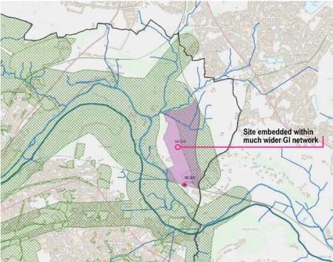
Build and Natural Environment Considerations The proposed strategic employment area is embedded in a much wider landscape, natural and built environment setting. This creates a conceptual framework to help shape the future the site and create more of a sense of place than is often the case with employment sites. A comprehensive green infrastructure and open space strategy is required as the site is positioned within a unique landscape with significant ecological and green infrastructure context which will require the strengthening of existing features, including the Avenue. Site NE22/E will require further detailed work on heritage impact and development setting, which may curtail development yield but also presents opportunities to anchor high quality heritage sensitive design. Fluvial and surface water flood risks across parts of the site will need to form part of a comprehensive strategy to water management and drainage.
Landscape Context Location of potential hazards
Creating a Sense of Place
This is a unique site which has the opportunity to create a sense of place. The design of new development in this area should be to a high standard with strong visual character and be of a high quality. A standard industrial estate format is not appropriate. Sensitive consideration will need to be given to building massing, which reflects the current Green Belt status of the land and facilitates landscaping and Green Infrastructure (GI) connectivity through the site. The site may appeal to particular environmental market sectors such as hi-tech industries and a comprehensive approach to place-marketing is required to fully maximise the opportunities offered by the site. Esholt presents a natural opportunity to drive growth in the green economy and establish a high quality model development. Development Framework Key aspects of the development framework for this site should include:
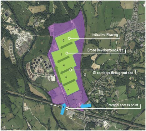
a) a clear spatial and site vision which creates a sense of place though high quality design / high specification standards (including a minimum of BREEAM Excellent) and a creative environment focused approach to building type, site layout and massing; b) site access, movement and connectivity – with reference to maximising active travel and public transport infrastructure within the scheme and connections to rail and bus transport corridors; c) a comprehensive green infrastructure, landscaping and open space strategy -linking the site to a much wider Green Belt, landscape, ecological and green corridor context, to include strengthening of existing features including the Avenue and public rights of way routes; d) detailed water management and drainage strategy addressing fluvial and surface water flood risks across parts of the site and site access constraints; d) a clear infrastructure, implementation and phasing strategy addressing land remediation and engraining planning for movement, fibre cabling, and high environmental standards for water, energy and heating infrastructure amongst other considerations with site phasing covering core employment space and ancillary uses.
Delivery and Uses The site(s) development would benefit from a comprehensive masterplan with clear phasing and delivery strategy. Development scales of (up to 100,000 sqm) on site NE23/E will need to be carefully managed to avoid impacts on established commercial and office centres. Proposed development mix of uses: Class B2, B8, E (B1a, b and c) and Ancillary E (A1, A3, D1 and D2), Sui generis (A5) are appropriate for the larger site.
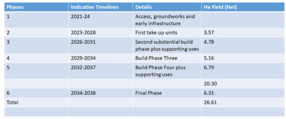
An indicative development timescale on site delivery, with build out estimates is shown below. |
|
(60) Consultation Question 75
Local Area Strategy and Plan - Wrose, Thackley and Idle
Q. Please provide any comments you may have on the area strategy?
If you have an alternative to the approaches undertaken, please provide further details and evidence in support.
(4) Consultation Question 76
Local Area Strategy and Plan - Undercliffe and Eccleshill
Q. Please provide any comments you may have on the area strategy?
If you have an alternative to the approaches undertaken, please provide further details and evidence in support.
(1) Consultation Question 77
Local Area Strategy and Plan - Barkerend
Q. Please provide any comments you may have on the area strategy?
If you have an alternative to the approaches undertaken, please provide further details and evidence in support.
(5) Consultation Question 78
Local Area Strategy and Plan - Esholt Strategic Employment Area
Q. Please provide any comments you may have on the area strategy?
If you have an alternative to the approaches undertaken, please provide further details and evidence in support.
Preferred Site Allocations and Site Pro-formas
5.2.52 The preferred site allocations for Bradford North East West for both employment and housing are detailed below in Tables A and B. These tables are subsequently followed by site pro formas for each preferred site allocation providing a summary of key site information and characteristics.
Table A: Bradford North East Employment Sites - Preferred Allocations
|
Site Ref |
Site Name |
Type |
Site Area (Hectares) |
Local Area |
|
NE22/E |
Walkhill Farm, Apperley Lane |
5% Brownfield/ 95% Greenfield (Greenbelt) |
4.94 |
Apperley Bridge/ Esholt |
|
NE23/E |
Apperley Bridge / Esholt (Former Filter Beds - Water Treatment Works) |
Brownfield (Greenbelt) |
26.61 |
Apperley Bridge/ Esholt |
|
NE24/E |
Land at Gain Lane and Woodhall Rd |
Greenfield |
9.85 |
Barkerend |
|
Total |
41.40 |
Table B: Bradford North East Housing Sites - Preferred Allocations
|
Site Ref |
Site Name |
Dwellings |
Local Area |
|
NE1/H |
Ravenscliffe Avenue, Ravenscliffe |
14 |
Undercliffe and Eccleshill |
|
NE2/H |
Westfield Lane and Kingsway, Wrose |
69 |
Wrose, Thackley and Idle |
|
NE3/H |
Westfield Lane (Rear Kingsway) Wrose |
30 |
Wrose, Thackley and Idle |
|
NE4/H |
Simpsons Green |
25 |
Wrose, Thackley and Idle |
|
NE5/H |
Prospect Road |
15 |
Barkerend |
|
NE6/H |
Exmouth Place |
75 |
Undercliffe and Eccleshill |
|
NE7/H |
Barkerend Mill, Barkerend Road |
150 |
Barkerend |
|
NE8/H |
Old Park Road, Thorpe Edge |
16 |
Wrose, Thackley and Idle |
|
NE9/H |
Arthur Street, Idle |
40 |
Undercliffe and Eccleshill |
|
NE10/H |
Ravenscliffe Avenue, Ravenscliffe |
24 |
Undercliffe and Eccleshill |
|
NE11/H |
Harrogate Rd, Greengates |
48 |
Wrose, Thackley and Idle |
|
NE12/HC |
Kings Drive, Wrose |
23 |
Wrose, Thackley and Idle |
|
NE13/H |
Rawson Avenue, Thornbury |
46 |
Barkerend |
|
NE14/H |
Joseph Street, Barkerend |
35 |
Barkerend |
|
NE15/H |
Hinchliffe Street |
6 |
Barkerend |
|
NE16/H |
Kyme Mills, Napier Terrace |
60 |
Barkerend |
|
NE17/H |
Steadman Street, Barkerend |
16 |
Barkerend |
|
NE18/H |
Rimswell Holt, Ravenscliffe |
6 |
Undercliffe and Eccleshill |
|
NE19/H |
Land east of Harrogate Rd, Greengates |
32 |
Wrose, Thackley and Idle |
|
NE20/HC |
Site of Ashfield Mills |
35 |
Wrose, Thackley and Idle |
|
NE21/H |
Blakehill Works, Bradford Road, Idle |
14 |
Undercliffe and Eccleshill |
|
Total |
779 |
Note: The sites labelled "HC" had outline planning permission at 31st March 2020. Further approval at NE21/H
(8) Consultation Question 79
Bradford North East Site Allocations and Site Pro Formas
The Local Plan sets out a series of preferred site allocations. If you wish to make representations on any of the sites proposed, please provide site reference and feedback under this question. If you wish to propose an additional or alternative site(s) to the preferred allocations listed, please also provide a plan with a red line and any further details in support.
[1] Universal Service Obligation (USO) - download speeds at or above 10Mbit/s and upload speeds at or above 1Mbit/s including non-matched records and zero predicted speeds
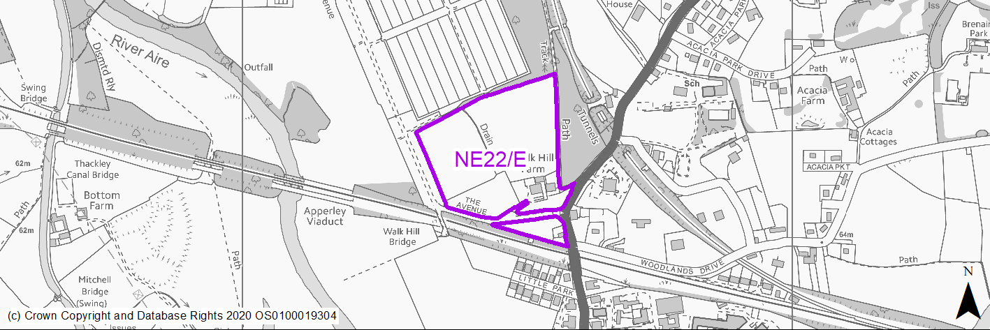
(9) NE22/E - Walkhill Farm, Apperley Lane
Site location
Regional City - Bradford NE
Ward
Idle & Thackley
Site description
Greenfield and Green Belt site with listed farm building on edge of major brownfield regeneration site.
Proposed Allocation
Employment
SHLAA referencce
NE/151
Indicative no. dwellings
N/A
Site area (Gross) (ha)
4.94
Ownership
Private
Delivery timescales
2030-35
Type (PDL/Greenfield)
PDL - 5% Greenfield - 95%
Green Belt
Yes
Flood Zone
Flood Zone 1 - low risk of flooding.
Potential site access
Harrogate Road / The Avenue junction below standard.
Public Transport Accessibility
Bus Stop within 400m Frequent service / Within 800m of Rail Station
Sustainability Appraisal
The site has been proposed for employment development, which would be likely to deliver a major boost to the range of local employment opportunities at this location whilst also providing a boost to the local economy. A major positive score has therefore been predicted for the employment and economy themed SA Objectives. A major positive score has also been predicted for the transport SA Objective due to the prevalence of public transport options in close proximity to the site.
Minor positive effects were predicted for other socio-economic themed SA Objectives due to the additional benefits of a new employment site, such as the potential for increasing the local offering of services and amenities and opportunities to learn new skills.
No major adverse effects have been predicted for the site, but minor adverse effects were predicted for a range of natural environment themed SA Objectives, primarily as a result of the impacts of new development on a majority greenfield and Green Belt site which contains trees in part of the site.
A Grade II Listed Building is situated in the south-east of the site, and it is likely that new employment development at this largely greenfield site would alter the setting of this sensitive heritage assets.
Habitats Regulations Assessment
This site falls within 7km of the South Pennine Moors SPA/SAC a HRA must be undertaken to ensure there are no significant effects on these protected sites. Developments within these zones must comply with Policy SP11; an SPD is being produced to provide further guidance.
Green Belt
See individual Green Belt site assessment in the accompanying report.
Constraints and Opportunities
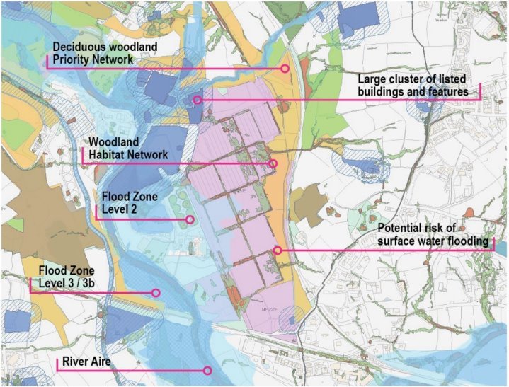
• Green Belt Site.
• Majority of the site falls within either 150 or 250m landfill buffer.
• Potential surface water flood risk within north western edge of the site.
• Listed building (Grade II) within south eastern corner of the site and with 50m buffer extending considerably within site.
• Significant proportion (eastern side) of the site considered to fall within wider Green Infrastructure corridor.
• Site bounded to the north / east by priority habitat (deciduous woodland) / woodland habitat network.
• Site abuts much larger brownfield regeneration site and former filter beds.
• Site is within close proximity to Apperley Bridge railway station.
Development considerations
• Further detailed work required on heritage impact assessment.
• Existing junction is considered substandard and further assessment required.
• Visible entrance site which will require a sensitive and high quality approach to development in keeping with heritage asset, which may limit overall development yield.
• Need to minimise any impact on existing habitat / ecological assets and support the delivery of GI through the scheme.
• Strengthen access links / orientation to railway station.
• Site would benefit from coming forward as part of a comprehensive masterplan and development strategy for the defined Apperley Bridge Strategic Employment Area.
Conclusion/Summary
Site could form a key gateway to the Apperley Bridge Strategic Employment Area through sensitive high quality design and masterplanning. Further site specific work will be required on heritage impacts and access arrangements.
Use Class
Class E (B1)
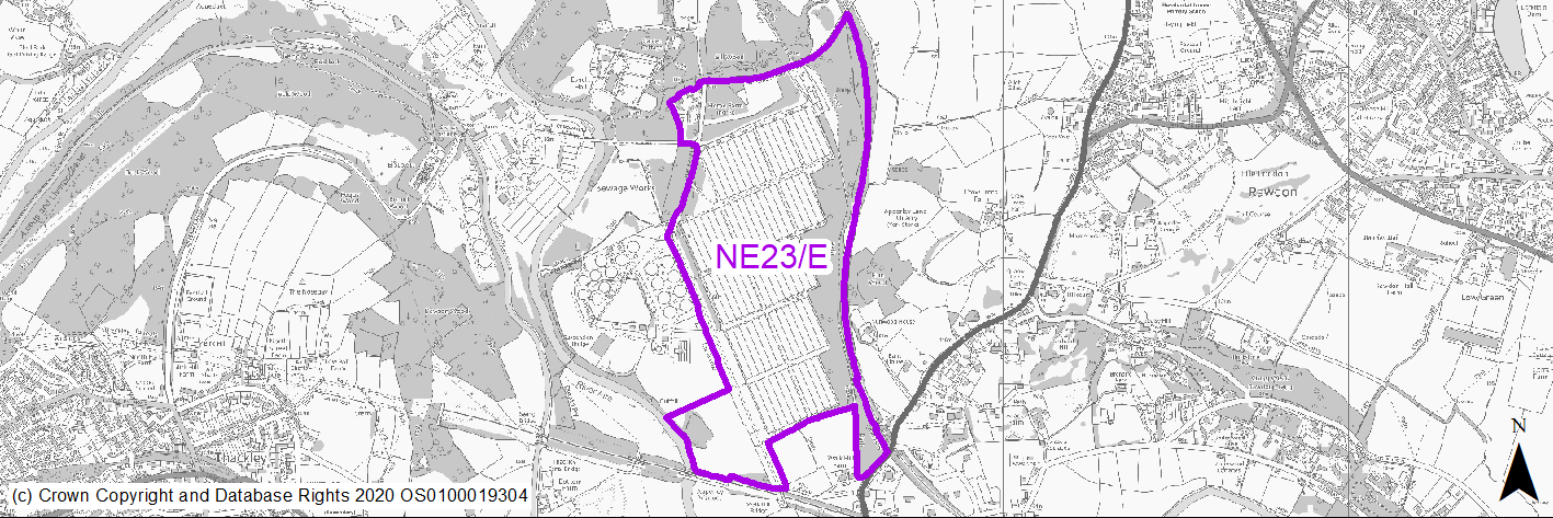
(8) NE23/E - Apperley Bridge / Esholt (Former Filter Beds - Water Treatment Works) Strategic Employment Area
Site location
Regional City - Bradford NE
Ward
Idle & Thackley
Site description
Large-scale brownfield regeneration site consisting of former filter beds within Green Belt valley location.
Proposed Allocation
Employment
SHLAA referencce
NE/051b
Indicative no. dwellings
N/A
Site area (Gross) (ha)
26.61 (PDL area)
Ownership
Private
Delivery timescales
2020-2038+
Type (PDL/Greenfield)
PDL - 100% (development platform).
Green Belt
Yes
Flood Zone
Flood Zone 1 - low risk of flooding in majority of the site / Flood Zone 2 in middle western section of the site and south western segment of the site together with extreme north west of the site / Flood Zone 3/3b within very extreme south west edge of the site and north west edge of the site is Flood Zone 3.
Potential site access road within Flood Zone 3.
Potential site access
Access would be from an improved Apperley Lane /Station Road junction. A new link road from this junction would be routed through the railway viaduct to the site.
Public Transport Accessibility
Bus Stop within 400m Frequent service / Within 800m of Rail Station
Sustainability Appraisal
The site has been proposed for employment development, which would be likely to deliver a major boost to the range of local employment opportunities at this location whilst also providing a boost to the local economy. A major positive score has therefore been predicted for the employment and economy themed SA Objectives.
A major adverse effect arises for the climate change resilience SA Objective due to the western perimeter of the site falling within Flood Zone 2, and small areas to the north-west and south west corners overlaps with Flood Zone 3. The site has multiple pockets of low, medium, and high surface water flood risk, and due to the distribution of this it may be difficult for the development to entirely avoid it.
Minor positive effects were predicted for other socio-economic themed SA Objectives due to the additional benefits of a new employment site, such as the potential for increasing the local offering of services and amenities and opportunities to learn new skills.
The site has a former utility use, is large and includes areas of GI elements and so a minor adverse effect was predicted for the biodiversity and geodiversity SA Objective. Two waterbodies are present in the north and west of the site and less than 100m of the site, the water quality of which would be at risk from development here.
There are six Grade II and one Grade II* Listed Buildings situated towards the north-west of the site, and it is likely that new employment development at this large site would alter the setting of these sensitive heritage assets.
The site falls within the Impact Risk Zones of South Pennine Moors SAC/SPA/SSSI and depending on the scale and type of employment development here, consultation with Natural England may be required as part of any planning application in order to ensure no adverse effects on the SAC/SPA/SSSI.
Habitats Regulations Assessment
This site falls within 7km of the South Pennine Moors SPA/SAC a HRA must be undertaken to ensure there are no significant effects on these protected sites. Developments within these zones must comply with Policy SP11; an SPD is being produced to provide further guidance.
Green Belt
See individual Green Belt site assessment in the accompanying report.
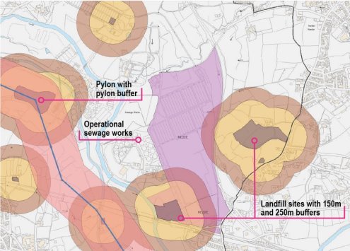
Constraints and Opportunities
• Strategic scale current Green Belt site (majority PDL).
• Main access route to site needs to be finalised.
• PDL site with extensive hard surfacing and former operational sewage treatment works.
• Proximity of the site to the operational sewage treatment works.
• Fluvial and surface water flood risks across parts of the site.
• Cluster of listed buildings with 50m buffer extending within the north west edge of the site.
• Landfill site (soils) within south western section of the site and extending 150m and 250m buffers, not considered a major constraint. Landfill buffer (250m) within the middle eastern section of the woodland habitat network and extending slightly within brownfield platform.
• Strong Green Infrastructure corridor through the eastern edge and north of the site.
• Woodland habitat network within the eastern section of the site.
• Priority habitat inventory (deciduous woodland) within site boundary.
• Southern section of the site within reasonably close proximity to rail connection and frequent bus network.
• Large linear site with decreasing accessibility the further away from public transport connections.
• Various PROW (Bridleways) within site.
Development considerations
• The site combined with NE22/E provides a unique strategic employment area (defined currently as Apperley Bridge Strategic Employment Area) for the delivery of premium quality employment space within an attractive valley landscape location. The site is identified to meet over 30% of the District’s employment land need during the plan period and has been identified as an emerging Spatial Priority Area within the wider West Yorkshire economic strategy context and is situated within close proximity to Leeds Bradford Airport and wider rail and road connections.
• The site is subject to an ongoing planning application (outline for employment uses) for which a comprehensive set of parameter plans as reserved matters will be required to progress beyond any outline approval together.
• The site has the potential to support the growth of the wider Bradford green economy with links to science, high technology and innovator businesses seeking a location with strong environmental credentials maximising green infrastructure and natural environment features.
• Key aspects of the development framework for this site should include:
- A progressive approach to site visioning, marketing and investment – unique site location with potential to attract inward investment within specialist sectors and attract enterprises and entrepreneurs looking for a distinct innovation focused community and location.
- A spatial framework and masterplan, supported by parameter plans concentrating upon: a) a clear spatial and site vision which creates a sense of place though high quality design / high specification standards (including a minimum of BREEAM Excellent) and a creative environment focused approach to building type, site layout and massing; b) site access, movement and connectivity – with reference to maximising active travel and public transport infrastructure within the scheme and connections to rail and bus transport corridors; c) a comprehensive green infrastructure, landscaping and open space strategy -linking the site to a much wider Green Belt, landscape, ecological and green corridor context, to include strengthening of existing features including the Avenue and PROW routes; d) detailed water management and drainage strategy addressing fluvial and surface water flood risks across parts of the site and site access constraints; d) a clear infrastructure, implementation and phasing strategy addressing land remediation and engraining planning for movement, fibre cabling, and high environmental standards for water, energy and heating infrastructure amongst other considerations with site phasing covering core employment space and ancillary uses.
• Scale of development and uses on site will need to be carefully managed to avoid impacts on established commercial and office centres.
• Scale of development up to 26.61 ha gross (brownfield only) and 100,000m2 of employment space within use classes defined within this pro forma.
Conclusion/Summary
Strategic scale employment site option which requires a comprehensive and innovative approach to site masterplanning and development to support indigenous business growth and attract inward investment. Site presents a natural opportunity to drive growth in the green economy and establish a high quality model development within a much wider landscape and green infrastructure context. Long term delivery project which needs a clear focus upon place-making and innovation and is identified as an emerging environmental and employment Spatial Priority Area (SPA) within the wider West Yorkshire investment context.
Use Class
Class B2/B8/E(B1a,b and c) + Ancillary E (A1,A3,D1 D2), Sui generis (A5)
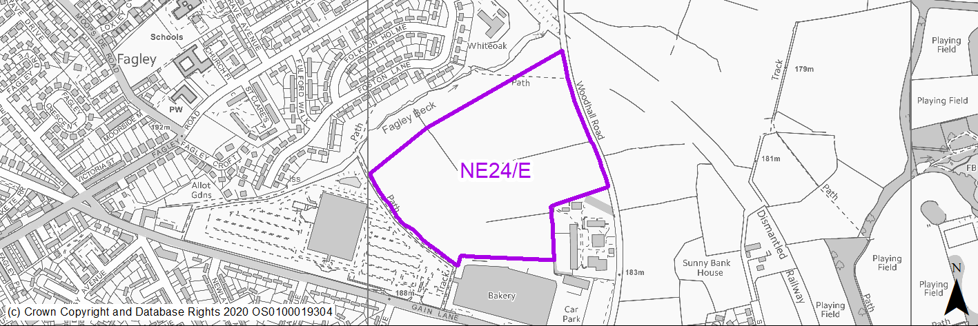
(2) NE24/E - Land At Gain Lane And Woodhall Road
Site location
Regional City - Bradford NE
Ward
Bradford Moor
Site description
Edge of urban greenfield site.
Proposed Allocation
Employment
SHLAA referencce
ELR/0044
Indicative no. dwellings
N/A
Site area (Gross) (ha)
9.85
Ownership
Private
Delivery timescales
2020-25
Type (PDL/Greenfield)
Greenfield - 100%
Green Belt
No
Flood Zone
Flood Zone 1 - low risk of flooding.
Potential site access
New site access in place.
Public Transport Accessibility
Bus Stop within 400m Frequent service
Sustainability Appraisal
See individual Sustainability Appraisal site comment in the accompanying report.
Habitats Regulations Assessment
This site is beyond the zones of influence of the South Pennine Moors SPA/SAC and is therefore unlikely to have any significant effects, a HRA is not required.
Green Belt
N/A – Site not within the Green Belt.
Constraints and Opportunities
• Bradford Enterprise Zone.
• Extensive area of TPO woodland adjacent to the south eastern edge of the site.
• Potential for limited surface water flooding in parts of the site.
Development considerations
• Site now underdevelopment in part with strong commercial interest in units.
Conclusion/Summary
Enterprise Zone site for which construction commenced during 2020.
Use Class
Class B2/B8
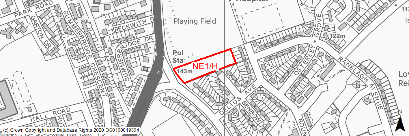
(1) NE1/H - Ravenscliffe Avenue, Ravenscliffe
Site location
Regional City - Bradford NE
Ward
Eccleshill ward
Site description
Derelict site, level and covered with overgrown vegetation.
Proposed Allocation
Housing
SHLAA referencce
NE/008
Indicative no. dwellings
14
Site area (Gross) (ha)
0.45
Ownership
Private
Delivery timescales
Developable (6-10 years)
Type (PDL/Greenfield)
Greenfield
Green Belt
No
Flood Zone
Flood Zone 1
Potential site access
No established vehicular access. Third party land is required to provide a safe access.
Public Transport Accessibility
Bus stop adjacent to site with good service 3 or 4 an hour.
Sustainability Appraisal
Development at this site would be unlikely to result in a significant effect, either positive or negative, on any SA Objective.
Minor positive effects were predicted for all socio-economic themed SA Objectives due to the benefits of new residential development for the local economy as well as the location of the site in relation to transport links, local services and amenities, education facilities and employment areas.
Minor adverse effects have been predicted for a range of natural environment themed SA Objectives, primarily as a result of the impacts of new development on a 100% greenfield site consisting of woodland including some TPO trees.
Habitats Regulations Assessment
This site is beyond the zones of influence of the South Pennine Moors SPA/SAC and is therefore unlikely to have any significant effects, a HRA is not required.
Green Belt
N/A – Site not within the Green Belt.
Constraints and Opportunities
• A sustainable location with good accessibility to services and public transport.
• Located within residential setting.
• Previous permission for housing.
• There appears to be a very restrictive covenant on the site which needs to addressed prior to seeking development.
• No established vehicular access. Third party land is required to provide a safe access.
Development considerations
• Development will need to consider how to mitigate any potential impact on the adjacent TPO woodland and onsite TPO trees.
• Safe, suitable and appropriate access needs to be established.
Conclusion/Summary
Whilst the site has constraints in terms of sensitive adjacent woodland and access, it has previously benefitted from planning permission. It is a fairly level site which is sustainably located within the settlement boundary and near to local services and facilities, including a primary school and open space.
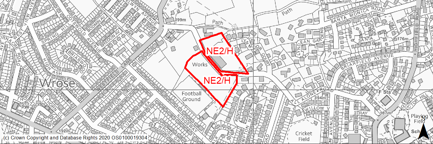
(6) NE2/H - Westfield Lane and Kingsway, Wrose
Site location
Regional City - Bradford NE
Ward
Idle and Thackley Ward
Site description
Unused site comprising demolished buildings bounded by dry stone wall and underused playing field separated by narrow lane.
Proposed Allocation
Housing
SHLAA referencce
NE/013A & NE/122
Indicative no. dwellings
69
Site area (Gross) (ha)
2.19
Ownership
Private
Delivery timescales
Developable (6-10 years)
Type (PDL/Greenfield)
Mixed
Green Belt
No
Flood Zone
Flood Zone 1
Potential site access
The previous approval required access through the football ground due to All Alone Road being substandard and this would be a requirement with any future planning application. This sites should be considered jointly but access will still be an issue.
Public Transport Accessibility
Bus stop with hourly service close by and 2 times per hour within 400m.
Sustainability Appraisal
No significant adverse effects predicted for the site. Minor adverse effects predicted for biodiversity as a result of impacts associated with development on greenfield. Minor adverse effects also predicted for water resources and air quality SA Objectives (as predicted for almost all sites). The site is well located to provide residents with good access to services, amenities, shops, jobs, public transport, schools, and health facilities, although the site is not within all target distances for any socio-economic themed SA Objective with no significant positive effects predicted for the site.
Habitats Regulations Assessment
This site falls within 7km of the South Pennine Moors SPA/SAC a HRA must be undertaken to ensure there are no significant effects on these protected sites in terms of recreational pressures. Developments within these zones must comply with Policy SP11; an SPD is being produced to provide further guidance.
Green Belt
N/A – Site not within the Green Belt.
Constraints and Opportunities
• Lack of suitable access to the northern part of the site.
• Surveys will be required relating to the effect of previous tipping.
• Large part of the site is designated as outdoor sports facilities.
• Development should respect significant mature trees and historic features of site to create a positive sense of place.
Development considerations
• Development of both land parcels should come forward comprehensively to ensure a suitable access solution is found.
• Masterplanning in conjunction with adjoining sites would be beneficial.
• New green infrastructure should be provided to aid the connectivity with adjacent land.
Conclusion/Summary
A mixed site in a sustainable location within the urban area. With suitable and appropriate access and sensitive design its development provides an opportunity to regenerate the area and provide around 69 homes.
(2) NE3/H - Westfield Lane (Rear Kingsway) Wrose
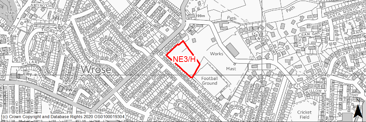
Site location
Regional City - Bradford NE
Ward
Windhill and Wrose Ward
Site description
Unused level green field.
Proposed Allocation
Housing
SHLAA referencce
NE/013C
Indicative no. dwellings
30
Site area (Gross) (ha)
0.81
Ownership
Private
Delivery timescales
Developable (6-10 years)
Type (PDL/Greenfield)
Greenfield
Green Belt
No
Flood Zone
Flood Zone 1
Potential site access
Access may need to be looked at, whilst available, it may be narrow and is shared with the properties fronting Westfield lane as rear access to their properties.
Public Transport Accessibility
Bus stop with hourly service close by and 2 times per hour within 400m.
Sustainability Appraisal
Development at this site would be unlikely to result in a significant effect, either positive or negative, on any SA Objective.
Minor positive effects were predicted for most socio-economic themed SA Objectives due to the benefits of new residential development for the local economy as well as the location of the site in relation to transport links, local services and amenities, and employment areas. However, access to both primary and secondary schools is somewhat limited due to the distances involved.
Minor adverse effects have been predicted for a range of natural environment themed SA Objectives, primarily as a result of the impacts of new development on a 100% greenfield site.
Habitats Regulations Assessment
This site falls within 7km of the South Pennine Moors SPA/SAC a HRA must be undertaken to ensure there are no significant effects on these protected sites in terms of recreational pressures. Developments within these zones must comply with Policy SP11; an SPD is being produced to provide further guidance.
Green Belt
N/A – Site not within the Green Belt.
Constraints and Opportunities
• Narrow site access.
• Small area of surface water flood risk in southern corner.
Development considerations
• The development of the site should incorporate new green infrastructure and new trees to aid connectivity with adjacent open space.
Conclusion/Summary
An urban greenfield site in a sustainable location. With suitable and appropriate access and sensitive design its development will provide at least 30 homes.
(6) NE4/H - Simpsons Green
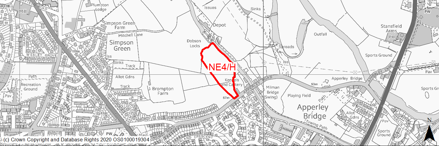
Site location
Regional City - Bradford NE
Ward
Idle and Thackley Ward
Site description
A large area consisting mainly of undulating pastureland, bounded by development on two sides and adjoining the Leeds-Liverpool Canal. Remaining unpermissioned part of safeguarded land allocation.
Proposed Allocation
Housing
SHLAA referencce
NE/025B
Indicative no. dwellings
25
Site area (Gross) (ha)
1.63
Ownership
Private
Delivery timescales
Developable (6-10 years)
Type (PDL/Greenfield)
Greenfield
Green Belt
No
Flood Zone
Flood Zone 1
Potential site access
Accessing this site at location shown on proposals map is not straight forward due to new access to adjacent development, existing properties and canal. A detailed assessment will be required through the planning process.
Public Transport Accessibility
Nearest bus stop (2/3 services per hour) is more than 400m away but easily accessible. Nearest Rail station is circa 650m away.
Sustainability Appraisal
No significant adverse effects predicted for the site. Minor adverse effects predicted for most natural environment themed SA Objectives, primarily as a result of impacts associated with development taking place on greenfield. The site is well situated to provide residents with good access to key services and amenities, including shops, jobs, health facilities and cultural spaces, with particularly good access to schools. The nearest bus stops and train station are outside the target distances of 400m and 800m.
Habitats Regulations Assessment
This site falls within 7km of the South Pennine Moors SPA/SAC a HRA must be undertaken to ensure there are no significant effects on these protected sites in terms of recreational pressures. Developments within these zones must comply with Policy SP11; an SPD is being produced to provide further guidance.
Green Belt
N/A – Site not within the Green Belt.
Constraints and Opportunities
• The majority of the site lies within the 200m buffer zone of overhead power line.
• The site lies adjacent to the canal conservation area and contains a listed building.
• Surface water flood risk across the central part of the site and the SE corner close to the listed building.
• Access is narrow and lies close to canal bridge and access to adjacent development.
Development considerations
• Mitigation to reduce the impact of development on the canal and the listed building. Topography and impact would make mitigation difficult. Potential for development without causing harm is probably limited.
• A Landscape and Visual Impact Assessment will need to be carried out.
• Design should avoid or mitigate impacts on the listed building to the south of the site and the conservation area.
• Development will need to incorporate quality open space and consider how to mitigate any surface water flooding issues.
Conclusion/Summary
Greenfield site suitable for residential development subject to sensitive design which reflects its location adjoining the canal conservation area. The development of the site should relate to new Brompton Fold development on SHLAA site NE/025A and mitigate any impact from the listed farm house.
(3) NE5/H - Prospect Road
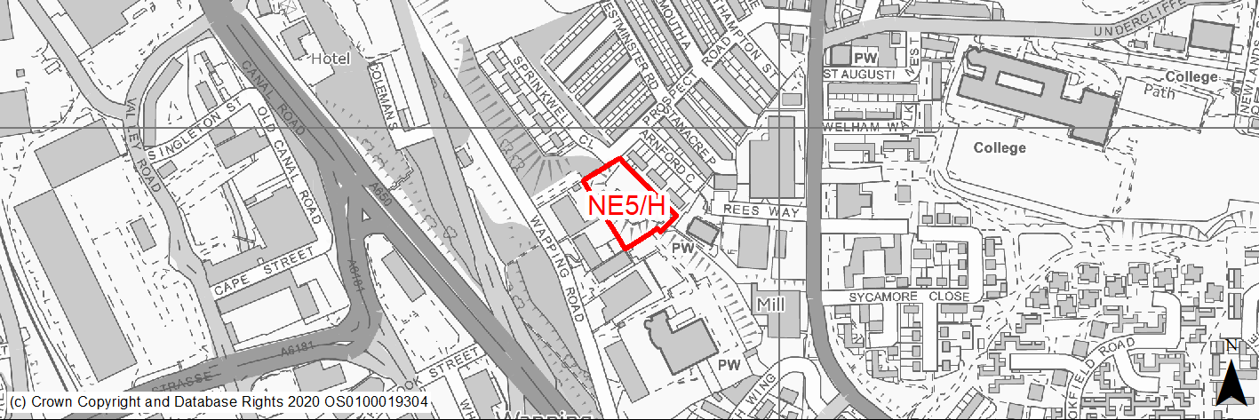
Site location
Regional City - Bradford NE
Ward
Bowling and Barkerend Ward
Site description
Mostly level, fenced off site. Part of the land is steeply sloping grassy bank adjoining rear of the former school to the west.
Proposed Allocation
Housing
SHLAA referencce
NE/031
Indicative no. dwellings
15
Site area (Gross) (ha)
0.49
Ownership
Private
Delivery timescales
Deliverable (0-5 years)
Type (PDL/Greenfield)
Greenfield
Green Belt
No
Flood Zone
Flood Zone 1
Potential site access
Established access from Prospect Road. Access could also be created from Wapping Road.
Public Transport Accessibility
Bus stop within 400m of the site with good service 3 or 4 an hour.
Sustainability Appraisal
The site could deliver major positive effects for residents on the health, transport and education SA Objectives as a result of being within the target distances for all necessary health facilities, bus stops and a rail link, and centres for primary and secondary education.
A significant adverse effect has been predicted for the air quality SA Objective as a result of the site being entirely within the CAZ. This could potentially make achieving air quality improvement targets within the CAZ more difficult.
Minor positive effects were predicted for all other socio-economic themed SA Objectives due to the benefits of new residential development for the local economy as well as the location of the site in relation to local services and amenities, and employment areas.
Minor adverse effects have been predicted for a range of natural environment themed SA Objectives, primarily as a result of the impacts of new development on a 100% greenfield site adjoining deciduous woodland priority habitat.
Habitats Regulations Assessment
This site is beyond the zones of influence of the South Pennine Moors SPA/SAC and is therefore unlikely to have any significant effects, a HRA is not required.
Green Belt
N/A – Site not within the Green Belt.
Constraints and Opportunities
• A sustainable location with good accessibility to services and public transport.
• Adjacent to Grade II listed Wapping Road School but sensitive development could be achieved without harm to setting.
• The site lies within the 150m buffer zone for a former landfill.
• Site lies within green infrastructure corridor.
• Air quality - the site lies within the draft clean air zone.
Development considerations
• Development should be sensitive to the adjacent listed building.
• New landscaping/tree planting should be provided to link with adjacent open areas and improve air quality.
Conclusion/Summary
Greenfield site in sustainable location which provides an opportunity to improve an unused area of land and regenerate the local area. The site is suitable for residential development subject to sensitive design and accommodate at least 14 homes.
(1) NE6/H - Exmouth Place
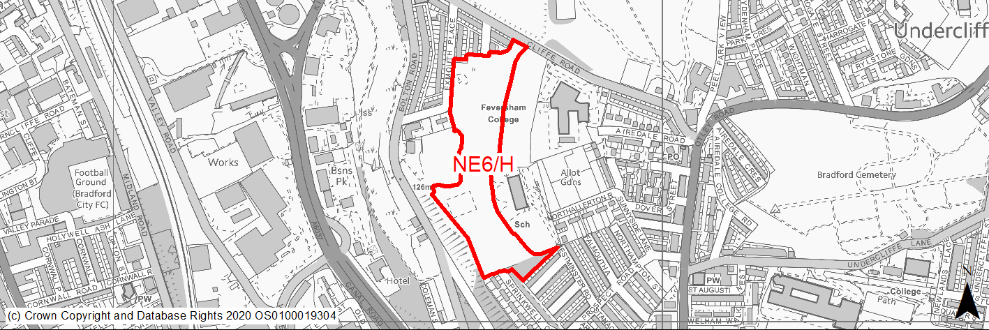
Site location
Regional City - Bradford NE
Ward
Bolton and Undercliffe Ward
Site description
Underused grassy patch of land which slopes steeply toward Exmouth Place and Wapping Road, located between school, playing fields and residential. The land contains a number of mature trees.
Proposed Allocation
Housing
SHLAA referencce
NE/034
Indicative no. dwellings
75
Site area (Gross) (ha)
3.78
Ownership
Council
Delivery timescales
Developable (6-10 years)
Type (PDL/Greenfield)
Greenfield
Green Belt
No
Flood Zone
Flood Zone 1
Potential site access
Existing access via Exmouth Place. Option to create new access through multiple points. Some residential development might be possible with access from Cliffe Road.
Public Transport Accessibility
Bus stop adjacent to site with good service 3 or 4 an hour.
Sustainability Appraisal
A significant adverse effect has been predicted for the air quality SA Objective due to the site being situated within the CAZ. A significant adverse effect can also not be ruled out for the cultural heritage objective. The site is 10m west of the Registered Park/Garden Peel Park. Development at this greenfield site could alter the setting of this important heritage asset.
Minor adverse effects predicted for most natural environment themed SA Objectives, primarily as a result of effects associated with development on greenfield.
The site is well located to provide residents with good access to key services and amenities, including shops, cultural spaces and jobs, with particularly good access to schools, public transport and health facilities.
Habitats Regulations Assessment
This site is beyond the zones of influence of the South Pennine Moors SPA/SAC and is therefore unlikely to have any significant effects, a HRA is not required.
Green Belt
N/A – Site not within the Green Belt.
Constraints and Opportunities
• The site lies within a draft green infrastructure corridor and has been subject to tipping in the past.
• Minor issues relate to surface water flooding, historic coal mining etc.
• Site lies in clean air zone.
Development considerations
• Surveys will be required to determine historic landfill and coal mining activity.
• A Landscape and Visual Impact Assessment will need to be carried out.
• Development will need to incorporate new and enhanced greenspace.
• Sensitive design will need to mitigate the impact of the development on the listed Peel Park which is a listed park and garden.
Conclusion/Summary
A greenfield site in a sustainable location within the urban area. The site is suitable for residential development which will need to be subject to sensitive design, retention of trees and resolution of any existing public access issues. Areas have been removed from the original site and retained for open space. New open spaces and landscaping will need to be designed to aid connectivity with these areas and others adjacent. The site can accommodate at least 75 homes but more could be appropriate subject to an acceptable design.
(3) NE7/H - Barkerend Mill, Barkerend Road
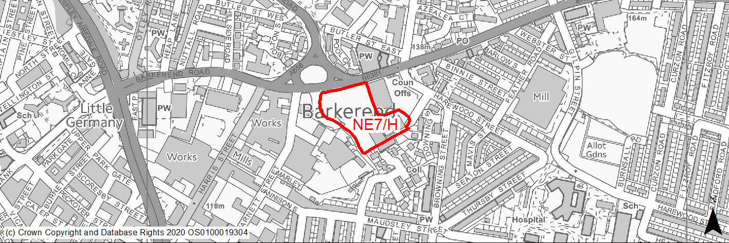
Site location
Regional City - Bradford NE
Ward
Bowling and Barkerend Ward
Site description
Substantial listed mill buildings and surrounding land in poor condition.
Proposed Allocation
Housing
SHLAA referencce
NE/035
Indicative no. dwellings
150
Site area (Gross) (ha)
1.1
Ownership
Private
Delivery timescales
Deliverable (0-5 years)
Type (PDL/Greenfield)
PDL
Green Belt
No
Flood Zone
Flood Zone 1
Potential site access
Site can be accessed from Barkerend Road and Harewood Street and is suitable for residential development. This is a large site and appears to be in multi ownership; in highway terms a holistic development proposal is preferred rather than piecemeal development. A few smaller residential proposals have not come to fruition.
Public Transport Accessibility
Bus stop adjacent to site with good service 3 or 4 an hour.
Sustainability Appraisal
A significant adverse effect has been predicted for the air quality SA Objective due to the site being within the CAZ. No other significant adverse effects have been predicted. As a PDL plot containing existing buildings, this site would be an opportunity to deliver biodiversity net gains and improvements to the local character and setting. The site falls within the South Pennine Moors SSSI/SPA/SAC Impact Risk Zones; thus, Natural England would need to be consulted to ensure no adverse effects on designated sites. One of the buildings within the site is the Grade II Listed Building ‘Barkerend Mill’, which is a large building understood to have been damaged in a fire. At this stage it is somewhat uncertain how this heritage asset would be impacted by the site allocation but it is considered to be likely that development here would be an opportunity to either repair and revitalise the asset or, if it is beyond repair, to deliver improvements to the local character by replacing the large fire-damaged building. The site is well located to provide residents with good access to key services and amenities, including shops, public transport, jobs, and cultural spaces, with particularly good access to schools and health facilities.
Habitats Regulations Assessment
This site is beyond the zones of influence of the South Pennine Moors SPA/SAC and is therefore unlikely to have any significant effects, a HRA is not required.
Green Belt
N/A – Site not within the Green Belt.
Constraints and Opportunities
• The entire site is covered by the listed building protection centred on the mill buildings themselves.
• Includes a Grade II listed building within the site.
• The site is located in a High Risk Area for former coal mining activity.
• Site lies within a draft green infrastructure corridor.
• Site subject to tipping in the past.
• There are also issues relating to surface water flooding, air quality etc.
Development considerations
• Land assembly will be required to bring this site forward.
• A comprehensive approach is preferred and piecemeal development should be avoided.
• Air quality issues will need to be mitigated by new tree planting and associated landscaping particularly along the Barkerend Road frontage.
• Development, design and layout should seek to protect the setting of the listed building. Includes one of Bradford's iconic mills that needs sensitive conversion/restoration.
• Proposal for residential development in the shape of conversion of the 3 mill buildings is currently under consideration (Ref 20/04492/MAF).
• Due to surface water flooding issues drainage would have to be carefully considered and sustainable systems and natural flood management incorporated into the design.
Conclusion/Summary
A previously developed site in a sustainable location within the urban area. Given sensitive design its redevelopment provides an opportunity to re-use a historic building and regenerate the area. The development of new homes on the land and conversion of the buildings could accommodate in the region of 150 homes, but detailed assessment of the buildings will determine what is possible.
(2) NE8/H - Old Park Road, Thorpe Edge
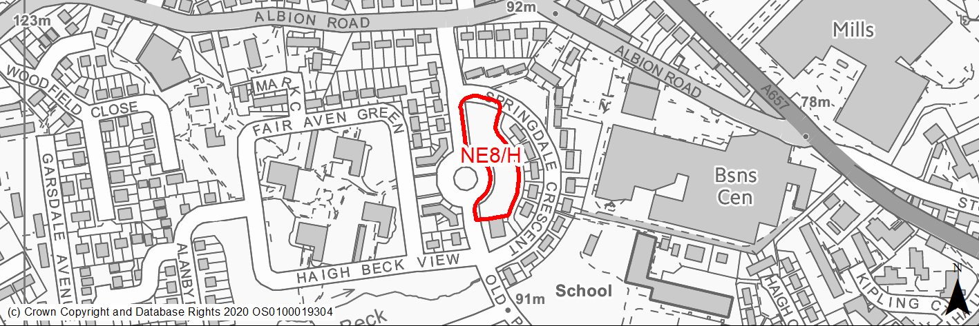
Site location
Regional City - Bradford NE
Ward
Idle and Thackley Ward
Site description
Open, grassed amenity green space in residential neighbourhood.
Proposed Allocation
Housing
SHLAA referencce
NE/045
Indicative no. dwellings
16
Site area (Gross) (ha)
0.35
Ownership
Private
Delivery timescales
Deliverable (0-5 years)
Type (PDL/Greenfield)
Greenfield
Green Belt
No
Flood Zone
Flood Zone 1
Potential site access
No access issues.
Public Transport Accessibility
Bus stop adjacent to site with good service 3 or 4 an hour.
Sustainability Appraisal
The site could deliver major positive effects for residents on both the health and education SA Objectives as a result of being within the target distances for all necessary health facilities and centres for primary and secondary education.
Minor positive effects were predicted for most socio-economic themed SA Objectives due to the benefits of new residential development for the local economy as well as the location of the site in relation to transport links, local services and amenities, and employment areas.
Although the site is greenfield it appears to be entirely mown grass, so in fact new development here could provide the opportunity to enhance the biodiversity value.
No major adverse effects have been predicted for the site, but the loss of the greenfield site would be likely to have a negative impact on the local landscape and townscape. Additionally, there is a small waterbody 60m south-west of the site which could be impacted by the construction and occupation of this site.
Habitats Regulations Assessment
This site falls within 7km of the South Pennine Moors SPA/SAC a HRA must be undertaken to ensure there are no significant effects on these protected sites in terms of recreational pressures. Developments within these zones must comply with Policy SP11; an SPD is being produced to provide further guidance.
Green Belt
N/A – Site not within the Green Belt.
Constraints and Opportunities
• Site currently only mown grass, development could provide the opportunity to enhance biodiversity value.
• Small pockets of surface water flood risk.
Development considerations
• Development will need to mitigate the loss of the amenity greenspace through enhanced tree/landscaping.
Conclusion/Summary
An opportunity for development on an unused greenfield site suitable for residential development. The site can accommodate at least 16 townhouses in linear form.
(1) NE9/H - Arthur Street, Idle
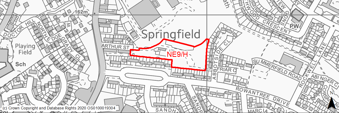
Site location
Regional City - Bradford NE
Ward
Eccleshill Ward
Site description
Existing scrap yard. Part of the site has naturalised with self-seeded trees.
Proposed Allocation
Housing
SHLAA referencce
NE/046
Indicative no. dwellings
40
Site area (Gross) (ha)
0.97
Ownership
Private
Delivery timescales
Deliverable (0-5 years)
Type (PDL/Greenfield)
PDL
Green Belt
No
Flood Zone
Flood Zone 1
Potential site access
Existing access will require modification to achieve full potential. Width is too narrow at certain points as highlighted in previous planning application stage.
Public Transport Accessibility
Bus stop adjacent to site with good service 3 or 4 an hour.
Sustainability Appraisal
No significant adverse effects predicted for the site. Minor adverse effects predicted for water resources and air quality SA Objectives, as predicted for nearly all sites. This PDL plot would be a good opportunity to deliver biodiversity net gains and improvements to the local character. The site is generally well situated to provide residents with good access to key services and amenities, including shops, cultural spaces, buses, jobs and schools, with particularly good access to health facilities.
Habitats Regulations Assessment
This site falls within 7km of the South Pennine Moors SPA/SAC a HRA must be undertaken to ensure there are no significant effects on these protected sites in terms of recreational pressures. Developments within these zones must comply with Policy SP11; an SPD is being produced to provide further guidance.
Green Belt
N/A – Site not within the Green Belt.
Constraints and Opportunities
• Part of the site contains protected woodland lies adjacent to a Priority Habitat Network.
• The site lies within the 150M buffer zone for a former landfill site.
• Site has major access issue and demolition of some existing housing may be required if site is to be developed.
Development considerations
• Previous permission refused on access and impact on trees and a new application will need to address these matters and provide appropriate mitigation.
• Development should incorporate habitat enhancement and reflect the sites position on the edge of a priority habitat corridor.
• The design should incorporate new green infrastructure to link with adjacent assets.
Conclusion/Summary
The development of the site will improve an otherwise underused brownfield site and regenerate the area. Appropriate access will need to be provided which may involve securing third party land. The site can accommodate at least 40 homes.
(2) NE10/H - Ravenscliffe Avenue, Ravenscliffe
Site location
Regional City - Bradford NE
Ward
Eccleshill Ward
Site description
Unused greenfield land fronting Ravenscliffe Avenue.
Proposed Allocation
Housing
SHLAA referencce
NE/047
Indicative no. dwellings
24
Site area (Gross) (ha)
0.5
Ownership
Private
Delivery timescales
Developable (6-10 years)
Type (PDL/Greenfield)
Greenfield
Green Belt
No
Flood Zone
Flood Zone 1
Potential site access
No access issues.
Public Transport Accessibility
Bus stop within 400m of the site and high frequency service.
Sustainability Appraisal
Minor positive effects were predicted for most socio-economic themed SA Objectives due to the benefits of new residential development for the local economy as well as the location of the site in relation to transport links, local services and amenities, education facilities and employment areas.
No major adverse effects have been predicted for the site, but minor adverse effects were predicted for a range of natural environment themed SA Objectives, primarily as a result of the impacts of new development on a 100% greenfield site.
Habitats Regulations Assessment
This site is beyond the zones of influence of the South Pennine Moors SPA/SAC and is therefore unlikely to have any significant effects, a HRA is not required.
Green Belt
N/A – Site not within the Green Belt.
Constraints and Opportunities
• Pedestrian access to the community centre runs through the centre of the site.
• Access requirements to be assessed.
Development considerations
• The frontage of the site offers the opportunity for the planting of street trees.
Conclusion/Summary
An opportunity to improve and re-use a unused site and regenerate the local area. Suitable for residential development subject to sensitive design and appropriate mitigation to air quality and GI issue.
(17) NE11/H - Harrogate Road, Greengates
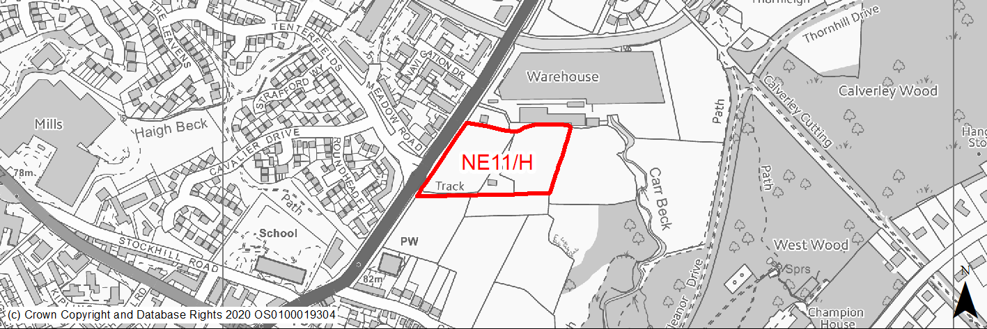
Site location
Regional City - Bradford NE
Ward
Idle and Thackley Ward
Site description
Unused, slightly sloped open greenfield part of a larger farmland with residential developments on two sides.
Proposed Allocation
Housing
SHLAA referencce
NE/055B
Indicative no. dwellings
48
Site area (Gross) (ha)
1.53
Ownership
Council
Delivery timescales
Developable (6-10 years)
Type (PDL/Greenfield)
Greenfield
Green Belt
No
Flood Zone
Flood Zone 1
Potential site access
Access from Harrogate Road.
Public Transport Accessibility
Not on high frequency bus route. Bus stops adjacent to the site providing hourly services. Nearest rail station Apperley Bridge is circa 900m away.
Sustainability Appraisal
The site could deliver a major positive effect for residents on the health SA Objective as a result of being within the target distances for all necessary health facilities.
Minor positive effects were predicted for most socio-economic themed SA Objectives due to the benefits of new residential development for the local economy as well as the location of the site in relation to transport links, local services and amenities, and education facilities.
No major adverse effects have been predicted for the site, but minor adverse effects were predicted for a range of natural environment themed SA Objectives, primarily as a result of the impacts of new development on a 100% greenfield and Green Belt site containing trees and hedgerows. The northern perimeter of the site is adjacent to the Leeds Liverpool Canal Conservation Area and there are two Grade II Listed Buildings 20m west of the site; development at this greenfield site could potentially result in an adverse effect on the setting of these. The site is less than 100m west of Carr Beck, so development here could potentially negatively impact the water quality.
Habitats Regulations Assessment
This site is beyond the zones of influence of the South Pennine Moors SPA/SAC and is therefore unlikely to have any significant effects, a HRA is not required.
Green Belt
N/A – Site not within the Green Belt.
Constraints and Opportunities
• Access could be taken from either Harrogate Road or via access from neighbouring development to the south subject to agreement.
• Site lies within a green infrastructure corridor and falls within the South Pennine Moors SSSI/SPA/SAC Impact Risk Zone.
• A small section of the land is within 250m landfill buffer zone.
• Within 50m buffer zone of a Listed Building.
Development considerations
• Sensitive site design will be required to mitigate any impact on the surrounding landscape and Green Infrastructure corridor with new landscaping provided to link with adjacent assets.
• A Landscape and Visual Impact Assessment will need to be carried out.
Conclusion/Summary
Greenfield site suitable for residential development subject to appropriate design, able to accommodate 48 homes. Consideration should be given to comprehensive development of the adjacent site to the east.
(1) NE12/HC - Kings Drive, Wrose
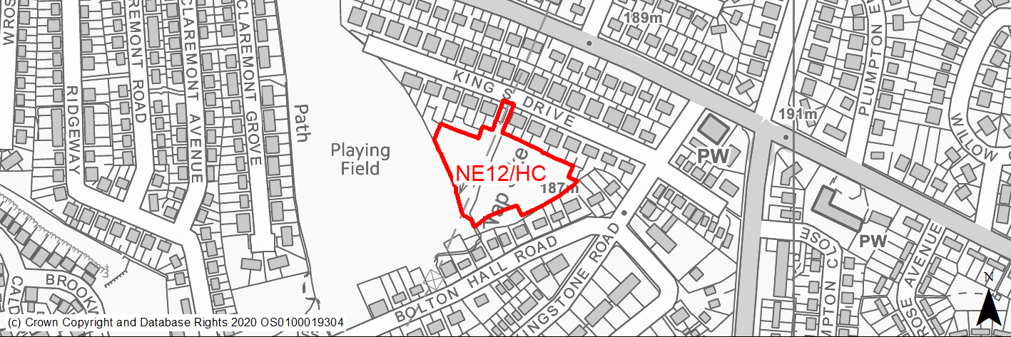
Site location
Regional City - Bradford NE
Ward
Windhill and Wrose Ward
Site description
Triangular open green space on the back of existing houses and a playing field.
Proposed Allocation
Housing
SHLAA referencce
NE/057
Indicative no. dwellings
23
Site area (Gross) (ha)
0.7
Ownership
Council
Delivery timescales
Deliverable (0-5 years)
Type (PDL/Greenfield)
Greenfield
Green Belt
No
Flood Zone
Flood Zone 1
Potential site access
Established access.
Public Transport Accessibility
Bus stop within 400m with 2 per hour services.
Sustainability Appraisal
The site could deliver a major positive effect for residents on the health SA Objective as a result of being within the target distances for all necessary health facilities.
No major adverse effects have been predicted. Minor positive effects were predicted for most socio-economic themed SA Objectives due to the benefits of new residential development for the local economy as well as the location of the site in relation to transport links, local services and amenities, education facilities and employment areas.
As a greenfield site entirely made up of woodland, development here has been predicted to result in minor adverse effects on most natural environment themed SA Objectives.
Habitats Regulations Assessment
This site falls within 7km of the South Pennine Moors SPA/SAC a HRA must be undertaken to ensure there are no significant effects on these protected sites in terms of recreational pressures. Developments within these zones must comply with Policy SP11; an SPD is being produced to provide further guidance.
Green Belt
N/A – Site not within the Green Belt.
Constraints and Opportunities
• RUDP designated recreation open space and the site is mapped as forming part of the local grassland habitat network.
• Stretch of land at risk of surface water flooding.
• High voltage pylon cable runs over the middle of the site.
Development considerations
• Recent study shows a tertiary water course (Trap Sike) is running mainly in open cut through the site. Due to the overgrown nature of the land it's been difficult to inspect much of its length. This will need to be culverted to accommodate development.
• Due to surface water flooding issues drainage would have to be carefully considered and sustainable systems and natural flood management incorporated into the design.
• A sensitive site design will be required to mitigate loss of habitat, recreation open space and enhance local ecology.
Conclusion/Summary
Whilst the site has constraints in terms of open space designation, habitat value and surface water flooding it is benefitted from a new outline planning application. It is a fairly level site which is sustainably located within the settlement boundary and near to local services and facilities, including a primary school and open space. Development would improve an open underused site and regenerate the area. Suitable for residential development subject to appropriate design and mitigating impact on environmental issues.
(1) NE13/H - Rawson Avenue, Thornbury
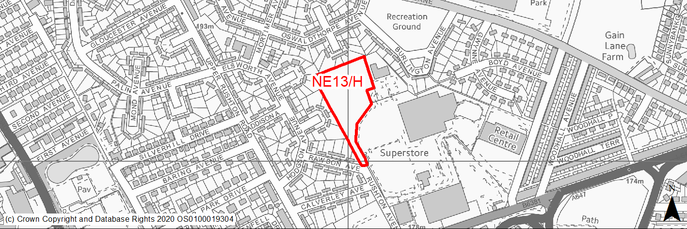
Site location
Regional City - Bradford NE
Ward
Bradford Moor Ward
Site description
Vacant, fenced off site next to supermarket/health centre car park.
Proposed Allocation
Housing
SHLAA referencce
NE/081
Indicative no. dwellings
46
Site area (Gross) (ha)
1.15
Ownership
Private
Delivery timescales
Developable (6-10 years)
Type (PDL/Greenfield)
PDL
Green Belt
No
Flood Zone
Flood Zone 1
Potential site access
Site can be accessed from Rushton Avenue.
Public Transport Accessibility
Bus stop with high frequency services within 400m.
Sustainability Appraisal
No significant adverse effects predicted for the site. The only minor adverse effects predicted are related to water consumption and air quality, as predicted for nearly all other sites. The site would be a good opportunity to deliver biodiversity net gains and improvements to the local character. The site is well located to provide residents with good access to key services and amenities, shops, buses, jobs and cultural spaces with particularly good access to both schools and health facilities.
Habitats Regulations Assessment
This site is beyond the zones of influence of the South Pennine Moors SPA/SAC and is therefore unlikely to have any significant effects, a HRA is not required.
Green Belt
N/A – Site not within the Green Belt.
Constraints and Opportunities
• Most of the site lies within 1/1000 year surface water flood risk.
Development considerations
• Site has surface water flooding issues but new drainage will mitigate and this should be incorporated into site layout.
• New areas of landscaping will provide enhanced local biodiversity gains and recreation value.
Conclusion/Summary
A well located urban site which has had permission for re use as a car park, but lies vacant. The development of the site for homes would improve a brownfield site and regenerate the area. Suitable for residential development of at least 46 homes.
(2) NE14/H - Joseph Street, Barkerend
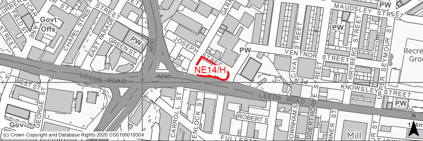
Site location
Regional City - Bradford NE
Ward
Bowling and Barkerend Ward
Site description
Levelled site currently being used as a temporary car park.
Proposed Allocation
Housing
SHLAA referencce
NE/090
Indicative no. dwellings
35
Site area (Gross) (ha)
0.2
Ownership
Private
Delivery timescales
Developable (6-10 years)
Type (PDL/Greenfield)
PDL
Green Belt
No
Flood Zone
Flood Zone 2
Potential site access
Multiple existing access routes and has been approved previously for commercial and residential uses.
Public Transport Accessibility
Bus stop adjacent to site with good service 3 or 4 an hour.
Sustainability Appraisal
A significant adverse effect has been predicted for the air quality SA Objective as a result of the site being situated within the CAZ, whilst also being 240m south of the AQMA. No other significant effects predicted. This site would be a good opportunity to deliver biodiversity net gains and improvements to the local character. The site would provide residents here with excellent access to public transport options, as well as schools and health facilities. Access to key services and amenities, shops, jobs and cultural/recreational spaces is good.
Habitats Regulations Assessment
This site is beyond the zones of influence of the South Pennine Moors SPA/SAC and is therefore unlikely to have any significant effects, a HRA is not required.
Green Belt
N/A – Site not within the Green Belt.
Constraints and Opportunities
• This is a previously developed site and provides the opportunity to regenerate land on a key approach road into the City centre.
• Air quality - the site is just 260m away from the local AQMA and lies within the draft CAZ.
• Within 50m buffer of a listed building.
Development considerations
• The design should incorporate Green Infrastructure in particular along the frontage with Leeds Road.
Conclusion/Summary
A small site but which could accommodate a medium/high density scheme such as a small urban apartment blocks. The land has had permission for residential previously.
(1) NE15/H - Hinchliffe Street
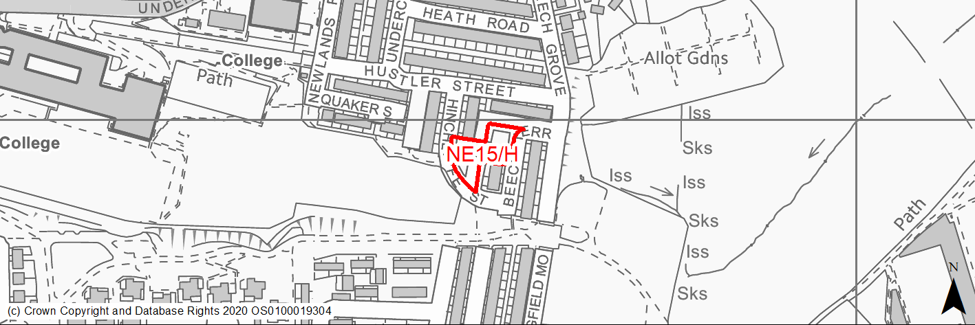
Site location
Regional City - Bradford NE
Ward
Bowling and Barkerend Ward
Site description
Sloping tipped land in residential neighbourhood. This is an irregularly shaped area of open land within a predominantly residential area. The site is in two parts with one section to the south of the odd numbered terrace of Hinchcliffe Street and the other immediately to the north of odd numbered terrace of Beech Terrace. The site slopes very steeply from the level of Hustler Street to the north to the bottom of Hinchcliffe Street. This is particularly pronounced adjacent to the retaining wall which supports the rear service road of 76-98 Hustler Street.
Proposed Allocation
Housing
SHLAA referencce
NE/109
Indicative no. dwellings
6
Site area (Gross) (ha)
0.2
Ownership
Private
Delivery timescales
Developable (6-10 years)
Type (PDL/Greenfield)
Greenfield
Green Belt
No
Flood Zone
Flood Zone 1
Potential site access
Established access from Hinchcliffe Street.
Public Transport Accessibility
Bus stop with high frequency services within 400m.
Sustainability Appraisal
Significant adverse effect predicted for NE/109 as a result of it being situated within the CAZ. Minor adverse effects have been predicted for most natural environment themed SA Objectives, primarily as a result of the impacts associated with new development on greenfield. The site is well located to provide residents with good access to key services and amenities, buses, jobs, and cultural spaces with particularly good access to schools and health facilities.
Habitats Regulations Assessment
This site is beyond the zones of influence of the South Pennine Moors SPA/SAC and is therefore unlikely to have any significant effects, a HRA is not required.
Green Belt
N/A – Site not within the Green Belt.
Constraints and Opportunities
• Site lies within draft Bradford Green Infrastructure Opportunity Corridor and falls within draft Clean Air Zone.
Development considerations
• Greenfield site which has had permission previously.
• Design should follow existing street pattern and contribute new trees to mitigate air quality issue.
• Given the residential nature of the surrounding area any proposed housing development is considered to be an appropriate form of development which achieves a housing density in accordance with the Council's density strategy.
Conclusion/Summary
Whilst the site has constraints in terms of steep slope, it has previously benefitted from outline planning permission. It is sustainably located within the settlement boundary and near to local services and facilities, including a primary school and open space. Development would improve this vacant site which is currently fly-tipped and would represent a significant visual improvement to this area.
(2) NE16/H - Kyme Mills - Napier Terrace - Moorside Lane
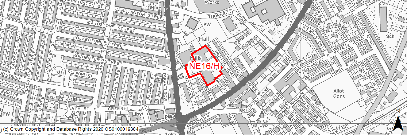
Site location
Regional City - Bradford NE
Ward
Bradford Moor Ward
Site description
Underused and partially derelict 4 storey mill building with redevelopment potential. The mill is part of a complex of similar industrial buildings, car parks and associated access.
Proposed Allocation
Housing (Mixed)
SHLAA referencce
NE/112
Indicative no. dwellings
60
Site area (Gross) (ha)
0.88
Ownership
Private/Council
Delivery timescales
Developable (6-10 years)
Type (PDL/Greenfield)
PDL
Green Belt
No
Flood Zone
Flood Zone 1
Potential site access
Multiple existing access routes/points. The site is accessed via Johnson Street and Scaley Street (off Killinghall Road) and Napier Terrace and Moorside Road/Lane (off Leeds Road).
Public Transport Accessibility
Bus stop adjacent to site with good service 3 or 4 an hour.
Sustainability Appraisal
The site could deliver major positive effects for residents on both the health and education SA Objectives as a result of being within the target distances for all necessary health facilities and centres for primary and secondary education.
A significant adverse effect has been predicted for the air quality SA Objective as a result of the site being adjacent to the CAZ. This could potentially make achieving air quality improvement targets within the CAZ more difficult.
Minor positive effects were predicted for most socio-economic themed SA Objectives due to the benefits of new residential development for the local economy as well as the location of the site in relation to transport links, local services and amenities, and employment areas.
The site is PDL containing buildings, so new development here would provide an opportunity to deliver biodiversity net gains, as well as to enhance the local townscape character. However, it is possible the large building within the site could be of local historic significance, despite not being a Listed Building.
Habitats Regulations Assessment
This site is beyond the zones of influence of the South Pennine Moors SPA/SAC and is therefore unlikely to have any significant effects, a HRA is not required.
Green Belt
N/A – Site not within the Green Belt.
Constraints and Opportunities
• The lies within the 250M buffer zone for a former landfill.
• Site contains a small pocket of area with potential surface water flooding issue.
• Site is under multiple ownership.
Development considerations
• Existing mill buildings are of heritage significance and constitute an undesignated heritage asset. They should be developed creatively and sensitively.
Conclusion/Summary
Underused buildings where residential re-use to is welcomed providing this is sensitive to the historic nature of the building and any existing uses.
(1) NE17/H - Steadman Street, Barkerend
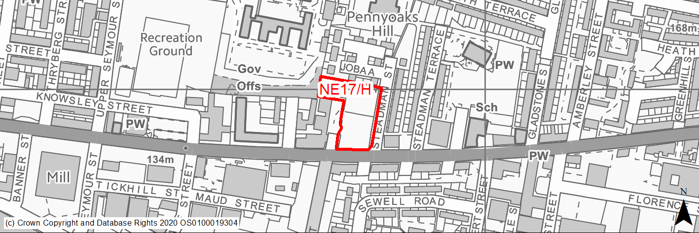
Site location
Regional City - Bradford NE
Ward
Bradford Moor Ward
Site description
Level and sloping land divided by retaining wall. The site is currently used as a vehicle scrapyard and a garage.
Proposed Allocation
Housing
SHLAA referencce
NE/113
Indicative no. dwellings
16
Site area (Gross) (ha)
0.47
Ownership
Private
Delivery timescales
Developable (6-10 years)
Type (PDL/Greenfield)
PDL
Green Belt
No
Flood Zone
Flood Zone 1
Potential site access
Existing access.
Public Transport Accessibility
Bus stop adjacent to site with good service 3 or 4 an hour.
Sustainability Appraisal
A significant adverse effect has been predicted for the air quality SA Objective as a result of the site being within the CAZ. No other significant adverse effects predicted. The site would be a good opportunity to deliver biodiversity net gains and improvements to the local character and setting. The site is well located to provide residents with good access to key services and amenities, shops, jobs, health facilities and cultural spaces, with particularly good access to schools.
Habitats Regulations Assessment
This site is beyond the zones of influence of the South Pennine Moors SPA/SAC and is therefore unlikely to have any significant effects, a HRA is not required.
Green Belt
N/A – Site not within the Green Belt.
Constraints and Opportunities
• The site lies within a clean air zone.
Development considerations
• Development will need to incorporate quality open space/landscaping to improve air quality.
Conclusion/Summary
This is an underused previously developed site in a sustainable area, which could be better used for homes and contribute toward regeneration in the area.
(1) NE18/H - Rimswell Holt, Ravenscliffe
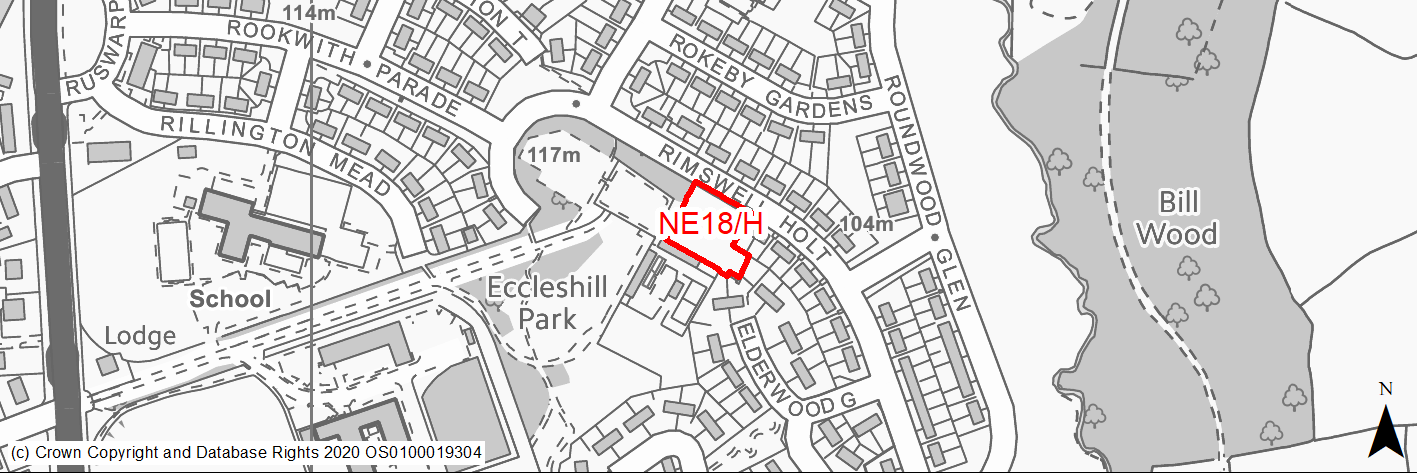
Site location
Regional City - Bradford NE
Ward
Eccleshill Ward
Site description
Cleared site formerly RC church. Opposite and adjacent residential and park.
Proposed Allocation
Housing
SHLAA referencce
NE/123
Indicative no. dwellings
6
Site area (Gross) (ha)
0.2
Ownership
Council
Delivery timescales
Developable (6-10 years)
Type (PDL/Greenfield)
Mixed
Green Belt
No
Flood Zone
Flood Zone 1
Potential site access
Established access.
Public Transport Accessibility
Bus stop adjacent to site with good service 3 or 4 an hour.
Sustainability Appraisal
No significant adverse effects predicted. Minor adverse effects predicted for most natural environment themed SA Objectives, primarily as a result of impacts associated with development on greenfield. The site is well located to provide residents with good access to key services and amenities, shops, jobs, buses, schools, and cultural spaces, with particularly good access to health facilities.
Habitats Regulations Assessment
This site is beyond the zones of influence of the South Pennine Moors SPA/SAC and is therefore unlikely to have any significant effects, a HRA is not required.
Green Belt
N/A – Site not within the Green Belt.
Constraints and Opportunities
• No constraints.
• Most part of the site lies within an area identified by Bradford Council as a draft Green Infrastructure Opportunity Corridor.
Development considerations
• Townhouses would best suit the site.
Conclusion/Summary
Development would improve an underused PDL site which has partially regenerated. The site is suitable for residential development.
(6) NE19/H - Land east of Harrogate Road, Greengates
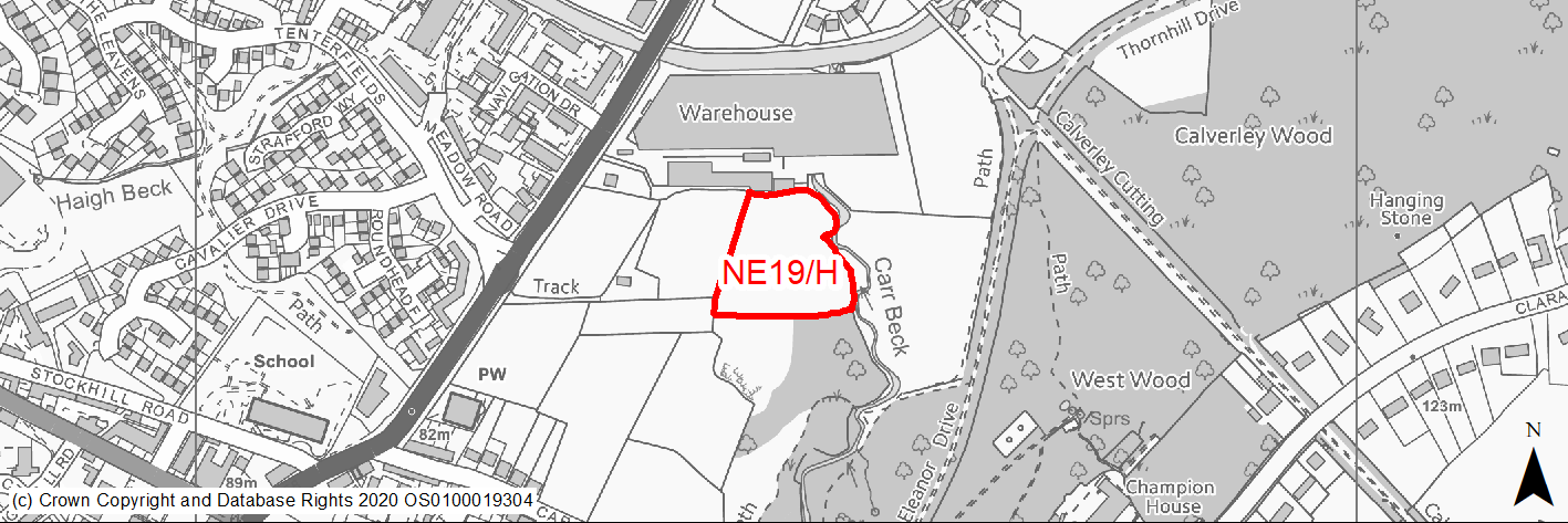
Site location
Regional City - Bradford NE
Ward
Idle and Thackley Ward
Site description
Unused, slightly sloping field with residential developments on two sides and edged by woodland.
Proposed Allocation
Housing
SHLAA referencce
NE/140
Indicative no. dwellings
32
Site area (Gross) (ha)
1.00
Ownership
Private
Delivery timescales
Developable (6-10 years)
Type (PDL/Greenfield)
Greenfield
Green Belt
Yes
Flood Zone
Flood Zone 3a on eastern edge
Potential site access
No direct access. New access need to be created through neighbouring housing estate.
Public Transport Accessibility
Not on high frequency bus route. Bus stops adjacent to the site providing hourly services. Nearest rail station Apperley Bridge is circa 900m away.
Sustainability Appraisal
Being within the target distances for all necessary health facilities, the site could deliver a major positive effect for residents on the health SA Objective.
A major adverse effect arises for the climate change resilience SA Objective due to the site’s eastern perimeter overlapping with land in the active Flood Zones 2 and 3, and falling within land at high risk of surface water flooding. More detailed flood risk assessments would likely be required for the site and careful consideration given to the layout of the development.
Minor positive effects were predicted for a range of socio-economic themed SA Objectives due to the benefits of new residential development for the local economy as well as the location of the site in relation to transport links, local services and amenities, and education facilities.
Minor adverse effects were predicted for a range of natural environment themed SA Objectives, primarily as a result of the impacts of new development on a 100% greenfield site adjacent to deciduous woodland priority habitat. The northern perimeter is adjacent to the Leeds Liverpool Canal Conservation Area, the setting of which could be adversely altered by the development.
Additionally, the site’s eastern perimeter is adjacent to Carr Beck so development here could pose a risk to water quality.
Habitats Regulations Assessment
This site is beyond the zones of influence of the South Pennine Moors SPA/SAC and is therefore unlikely to have any significant effects, a HRA is not required.
Green Belt
See individual Green Belt site assessment in the accompanying report.
Constraints and Opportunities
• Site is located adjacent to woodland, which is important for wildlife and biodiversity.
• The development of the site will have an impact on the landscape.
• Site’s eastern perimeter overlaps with land in the active Flood Zones 2 and 3, and falling within land at high risk of surface water flooding.
• The site slopes steeply towards the east.
• New access will need to be created from the west.
• Site is adjacent to green infrastructure corridor and Conservation Area.
Development considerations
• Development of the site should be sensitive to the conservation area, woodland to the east and landscape.
• Layout should incorporate strong landscaping and incorporate additional green infrastructure to aid the connectivity of the site with open areas to the east and south.
• Woodland edge along Carr Beck should be strengthened.
• A Landscape and Visual Impact Assessment will need to be carried out.
• All development should be subject to detailed flood risk assessment.
Conclusion/Summary
Greenfield site adjacent to new development at the north and south and further development site NE11/H to the west. The site should be developed comprehensively alongside NE11/H.
(2) NE20/HC - Site of Ashfield Mills, Ashfield Road, Idle
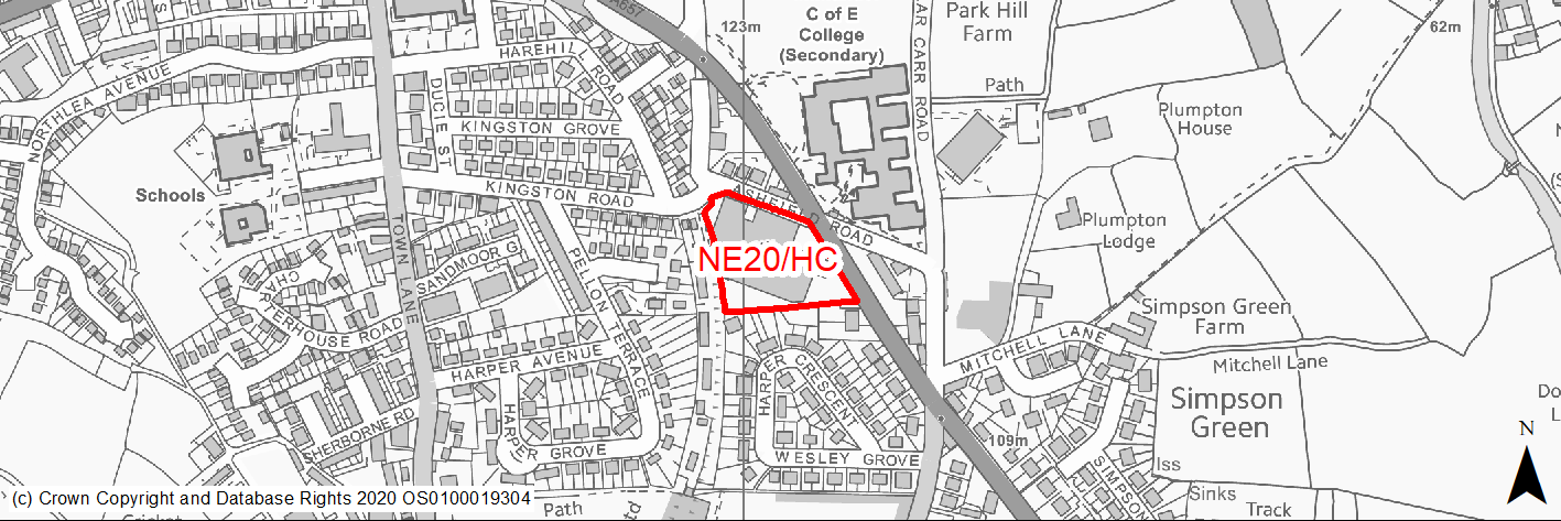
Site location
Regional City - Bradford NE
Ward
Idle and Thackley
Site description
The site is located to the west of Leeds Road and to the south of Ashfield Road and is currently occupied by a mill building. The site is currently occupied by a mill building and associated car park and servicing area.
Proposed Allocation
Housing
SHLAA referencce
NE/163
Indicative no. dwellings
35
Site area (Gross) (ha)
0.88
Ownership
Private
Delivery timescales
Deliverable (0-5 years)
Type (PDL/Greenfield)
PDL
Green Belt
No
Flood Zone
Flood Zone 1
Potential site access
Established access from Leeds Road. Also possible via Ashfield Road.
Public Transport Accessibility
Bus stop adjacent to the site provides 2 services per hour. High frequency bus stop within 400m to the west.
Sustainability Appraisal
The site could deliver major positive effects for residents on both the health and education SA Objectives as a result of being within the target distances for all necessary health facilities and centres for primary and secondary education.
Minor positive effects were predicted for most socio-economic themed SA Objectives due to the benefits of new residential development for the local economy as well as the location of the site in relation to transport links, local services and amenities, and employment areas.
As a PDL site containing existing buildings, there are opportunities for achieving biodiversity net gains and enhancing the local townscape character, depending on how the development is designed and implemented.
There are no major adverse effects predicted for the site, but its northern perimeter falls within land at medium and high risk of surface water flooding, meaning a minor adverse effect is predicted for the climate change resilience SA Objective. The only other minor adverse effects are related to increases in air pollution and water consumption, which have been predicted at nearly all sites.
Habitats Regulations Assessment
This site falls within 7km of the South Pennine Moors SPA/SAC a HRA must be undertaken to ensure there are no significant effects on these protected sites in terms of recreational pressures. Developments within these zones must comply with Policy SP11; an SPD is being produced to provide further guidance.
Green Belt
N/A – Site not within the Green Belt.
Constraints and Opportunities
• The site history and identified previous site uses are considered to have the potential to give rise to some localised ground contamination of the site, with the principal risk associated with the above and below ground storage tanks, although the overall perceived risk associated with the site is considered to be low to moderate.
• Concerns regarding the relationship of residential developments to the trees on the adjacent land which could lead to pressure for their future pruning or removal.
• There are small pockets along the northern boundary of the site which are at risk from surface water flooding.
• Recent outline planning permission granted for residential development.
Development considerations
• New developments require a long term sustaining use and construction of a complementary built form to replace demolished mill.
• Any opportunity to create and enhance green space and biodiversity gain should be maximised.
• Given the residential nature of the surrounding area any proposed housing development should aim to achieves a housing density in accordance with the Council's density strategy.
Conclusion/Summary
A mixed previously developed site in a sustainable location within the urban area suitable for residential development subject top sensitive design, retention of any trees and resolution of any issues relating to the location of the sewer.
(2) NE21/H - Blakehill Works, Bradford Road, Idle
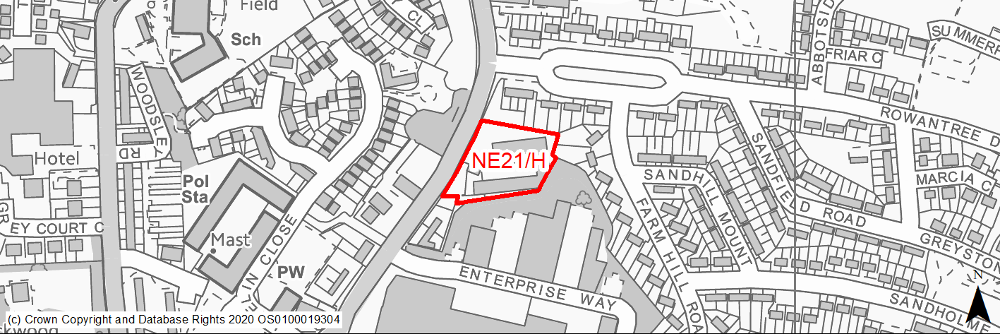
Site location
Regional City - Bradford NE
Ward
Eccleshill Ward
Site description
Vacant site of demolished industrial premises.
Proposed Allocation
Housing
SHLAA referencce
NE/182
Indicative no. dwellings
14
Site area (Gross) (ha)
0.5
Ownership
Private
Delivery timescales
Deliverable (0-5 years)
Type (PDL/Greenfield)
PDL
Green Belt
No
Flood Zone
Flood Zone 1
Potential site access
Established access.
Public Transport Accessibility
Adjacent bus stop provides high frequency bus services.
Sustainability Appraisal
The site could deliver a major positive effect for residents on the health SA Objective as a result of being within the target distances for all necessary health facilities.
Minor positive effects were predicted for nearly all other socio-economic themed SA Objectives due to the benefits of new residential development for the local economy as well as the location of the site in relation to transport links, local services and amenities, and education facilities.
The site is PDL containing existing buildings, so new development here would provide opportunities for achieving biodiversity net gains and enhancing the local townscape character, depending on the design and implementation of the development. The only adverse effects predicted for the site are minor and related to increases in air pollution and water consumption, which have been predicted at nearly all sites.
Habitats Regulations Assessment
This site falls within 7km of the South Pennine Moors SPA/SAC a HRA must be undertaken to ensure there are no significant effects on these protected sites in terms of recreational pressures. Developments within these zones must comply with Policy SP11; an SPD is being produced to provide further guidance.
Green Belt
N/A – Site not within the Green Belt.
Constraints and Opportunities
• A number of potential pollution linkages could exist within the site based on historical buildings and demolition works on site and the surrounding land use.
• The site lies within 150m and 250m buffer zone of 2 former landfill sites.
• There are small pockets within the site which are at risk from surface water flooding.
• Concerns regarding the relationship of residential developments to the mature trees on the site.
• Recent outline planning permission granted for residential development.
Development considerations
• An intrusive site investigation is recommended to confirm potential land contamination.
• Any opportunity to create and enhance green space and biodiversity gain should be maximised.
• Given the residential nature of the surrounding area any proposed housing development should aim to achieves a housing density in accordance with the Council's density strategy.
Conclusion/Summary
A mixed previously developed site in a sustainable location within the urban area suitable for residential development subject top sensitive design, retention of any trees and resolution of any issues relating to the location of the sewer.