
Draft Bradford District Local Plan - Preferred Options (Regulation 18) February 2021
Haworth
Introduction
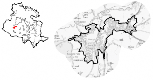
5.22.1 The village of Haworth is located within the South Pennine sub- area of Bradford District and the Worth Valley Ward. It lies within the folds of the Pennine moorlands between the settlements of Oxenhope and Oakworth. The settlement is located approximately 16km west of Bradford and 6.5km south-west of Keighley. It is largely residential in nature, with some local services. Haworth is an important tourist destination due to its historical associations with the Bronte's (there is a visitor centre and museum in the village) and the preserved steam railway and associated museum.
Figure 1: Location Plan
5.22.2 Haworth has a total population of 6,259 with the majority of this (62.2%) falling within the working age category (16-64). The working age profile of the settlement is comparable to the West Yorkshire average with a higher percentage of over 65s (20.5% compared to the sub-regional average of 16.7%). The ethnic composition of Haworth is primarily made up of people who identify themselves as White British - accounting for 95%. This is a notably higher proportion than the West Yorkshire average (78.4%), but is similar to other smaller rural settlements in the District.
Planning for Prosperity
5.22.3 The Local Plan settlement hierarchy identifies Haworth as one of the district's 11 Local Service Centres. This means that it will see a smaller scale of development, comprising both market and affordable housing, as well as the protection of its local centre to help ensure the continued provision of economic activity in the area
Economy and Employment
5.22.4 Economic activity rates are relatively high for Haworth with 74.4% of the resident population economically active compared to the West Yorkshire average (68.5%). Average household income at £42,500, is higher than the West Yorkshire average (£38,499). The main employment sectors that the residents of Cullingworth work in include retail, health and social work and manufacturing.
5.22.6 Due to the world-wide appeal of the Brontes, tourism is the single biggest industry in the area; local people are employed in a combination of recreational, historical and cultural visitor attractions. Visitor surveys indicate that over one million visitors a year come into the area.
5.22.7 There are no longer any designated employment areas within the village. In order to access a wider range of employment opportunities, residents need to commute to the larger centres of Bradford, Keighley and Halifax.
5.22.8 Business Register and Employment Survey (BRES) data indicates that the three largest industry groups by workforce jobs (all people in employment) are: hotels and catering (18.2%), health (16.3%) and retail (12.5%).
Retail
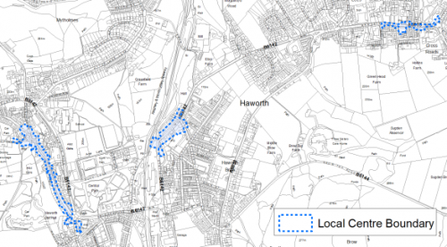
5.22.9 There are three defined retail centres in Haworth; Main Street in the centre of Haworth, Mill Hey which is to the east of the centre and a small retail centre in the Cross Roads locality.
5.22.10 Haworth Village Centre is a long linear centre focused on the semi-pedestrianised Main Street, a narrow street rising steeply to the north. With its strong historic character, Main Street is a popular tourist destination for visitors attracted to the Bronte association. As a result, the local centre, in contrast to others within the Bradford District, exists primarily to serve this tourist market rather than to meet the needs of local residents.
5.22.11 The 2019 Retail and Leisure Study found that Haworth is one of the District's largest local centres with 55 retail units. Out of these there are five convenience uses, largely aimed at tourists (chocolatier, sweet shop, bakers) and 28 comparison units, which are also overwhelmingly aimed at the tourist market, including gifts/card shops, art galleries, craft shops, second-hand shops and a new age shop. The only retail service units present are a hairdresser and a Post Office.
5.22.12 Mill Hey is a linear area located in the eastern end of Haworth, approximately 6km to the south west of Keighley town centre and 1km from the main Haworth village centre, via Bridgehouse Lane. Mill Hey operates as a separate local centre; it adjacent to the Worth Valley heritage railway station and museum, which is an important visitor attraction. Although tourism is important to the centre, it is much less of a factor than in Haworth village Centre (Main Street). Mill Hey centre primarily serves local residents; it has relatively large Spar, model shop, army surplus store, two hardware stores, a pharmacy and a pet shop.
5.22.13 The Retail Study recognises Haworth as a unique centre with significant heritage value and of great importance to the tourism economy. It is unique in the District as catering almost solely to the tourist market rather than in meeting local needs. As this situation is entrenched and is unlikely to change, the study recommends that Mill Hey be the focus for meeting local service and retail needs.
5.22.14 A third retail centre is located in the Cross Roads locality to the east of Haworth. It is a small linear centre located on Haworth Road comprising 13 units which predominantly meet convenience needs. The Retail Study notes that it is a healthy local centre with a good mix of essential shops and services to serve its local catchment.
Figure 2: Mill Hey, Haworth Main Street and Cross Roads Local Centres
Transport and Access
5.22.15 The A629, an inter-Yorkshire road that runs from Skipton, in the north to Rotherham, in the south, passing through Keighley, Halifax, Huddersfield and Chapeltown.
5.22.16 There are frequent bus services to Keighley and Hebden Bridge and along with an hourly service to Bradford departing from Cross Roads (Halifax Road). The only railway station in Haworth is a heritage railway which runs a limited service steam train between Oxenhope and Keighley. The nearest commuter station is around 5km away in Keighley. Leeds Bradford International Airport is 20km away.
5.22.17 There are numerous footpaths and bridleways leading out of the settlement into the countryside and connecting with the wider public rights of way network.
5.22.18 In relation to digital accessibility, average broadband download speed in Haworth is almost 42 megabytes per second which is slightly below the West Yorkshire average of 44.57. There are no premises where speeds are below the Universal Service Obligation (USO)[1].
Planning for Homes
5.22.19 Haworth has 3,071 dwellings which are mostly owner occupied (74%), this is higher than the regional average (63.4%). Just 4.5% are socially rented compared to the regional average of 19%.
5.22.20 There are a mix of house types in Haworth with the highest proportion being mainly older terraced properties located around the central historic core settlement (52%). Semi-detached (23%) and detached (14%) properties being the dominant dwelling type in the newer housing estates to the north and south and in Cross Roads. Around half of the village's houses were built prior to 1900 which is much higher than the regional average (18%).
5.22.21 The average house price in Haworth is £157,714 (2020), average house prices in Haworth are below regional averages for detached and semi-detached but higher for terraced and flatted properties. Figure 3. This would equate to an income multiplier of 3.76.
Figure 3: Haworth – House Prices
|
Average house price (all types of housing) (Land registry Sept-19 to August-20) |
Average house price (detached) (Land registry Sept-19 to August-20) |
Average house price (flats) (Land registry Sept-19 to August-20) |
||
|
£157,714 |
£250,667 |
£143,400 |
||
|
West Yorkshire average = £183,194 |
West Yorkshire average = £324,872 |
West Yorkshire average = £128,299 |
||
|
Average house price (semi-detached) (Land registry Sept-19 to August-20) |
Average house price (terraced) (Land registry Sept-19 to August-20) |
Households in Council Tax Band A (Valuation Office Agency (VOA) 2020) |
||
|
£168,000 |
£142,612 |
1,203 |
||
|
West Yorkshire average = £178,439 |
West Yorkshire average = £132,430 |
39.0% (West Yorkshire average = 43.1%) |
||
|
Households in Council Tax Band B (VOA 2020) |
Households in Council Tax Band C (VOA 2020) |
Households in Council Tax Band F-H (VOA 2020) |
||
|
605 |
507 |
181 |
||
|
19.6% (West Yorkshire average = 20.2%) |
16.5% (West Yorkshire average = 17.6%) |
5.9% (West Yorkshire average = 4.3%) |
5.22.22 The delivery of new housing is a key part of the development strategy for Haworth. This will ensure that the housing needs of local people can be met, both in terms of market and affordable housing. New housing will also allow for the modest growth of the settlement, to attract new residents and to help sustain the provision of services and facilities.
5.22.23 Policy SP8 in the local plan sets out a minimum requirement of 250 dwellings to be delivered in Haworth during the plan period. These will be delivered through a mix of committed sites (those under construction or have planning permission but have not yet commenced) and allocations. Table 1 below sets out the housing position for Haworth, which also includes the application of non-implementation or discount rates for planning permissions and allocations.
5.22.24 Once the commitments are discounted and removed from the supply, this leaves a residual allocation requirement of 181 units. The evaluated total site supply of housing units from the preferred allocation site equates to 204 units which is in turn discounted by 10% for non-implementation or under delivery leaving a final allocation contribution of 184 units.
Table 1: Haworth - Summary of Housing Requirement and Supply
|
Housing Target |
250 units |
|
Carried Forward Commitments |
77 |
|
Commitment Discounted by 10% |
69 |
|
Remaining Allocation Requirement |
181 |
|
Identified Allocations |
204 |
|
Allocations Discounted by 10% |
184 |
|
Total Supply Contribution from Allocations |
184 |
5.22.25 A portfolio of six sites have been identified as the preferred set of site options for Haworth to meet the housing the requirement. These consist of two brownfield sites, Ebor Mills and Ivy Bank Lane and four greenfield sites, none of which are in the Green Belt. The Council considers that the proposed level of growth within this area can be met without any need to make change to or release land from the green belt. Further information on these proposed allocations is set out in Table A and identified on the Policies Map and the Site Pro Forma below together with the local strategies map for each plan area. Development of site allocations should be in accordance with specified development guidelines and approximate site provision figures and all other relevant policies of this Local Plan. The Council will be supportive of additional proposals for new homes on additional small sites, particularly those that provide a redevelopment opportunity to bring forward land which has been previously used. Support will also be provided to developers who wish to redevelop larger sites and/or buildings for new homes not currently identified, subject to all relevant policies in the Local Plan.
Planning for Places and Communities
Green Belt, Natural Landscape and Historic Character
5.22.26 Haworth is surrounded by Green Belt; this land that surrounds the urban area of Haworth falls within the Worth and North Beck Valleys Landscape Character Area and the Yorkshire Southern Pennine Fringe National Character Area. There is a mix of landscape types surrounding Haworth:
- Upland pasture – Two small pockets of fields on a perched plateau on the eastern valley slopes above Haworth. Described as having strong character, high historic continuity and visual prominence and feelings of openness this landscape type is sensitive to further development.
- Mixed upland pasture -Small areas between the Keighley-Worth Valley railway and the eastern flank of Haworth, to the north east of Brow Moor. Described as having strong character, high historic continuity and visual prominence and feelings of openness, this landscape type is sensitive to further development.
- Wooded valley - Along the Worth Valley and Bridgehouse Beck Valley. Described as having moderate strength of character, high historic continuity, visibility and a degree of enclosure, the wooded valleys are moderately sensitive to development.
5.22.27 The local landscape also has important cultural connections to the Bronte's, in particular the moorlands to the west of Haworth to Top Withens (the ruined farmhouse said to be the inspiration for Wuthering Heights). The landscape has been identified as being prominent and open and in declining condition, with moderate strength of character and medium historic continuity.
5.22.28 The majority of the west of the settlement is designated as Haworth Conservation Area. This covers the oldest surviving part of the village including the St Michael's Church, Haworth Old Hall. The Parsonage and other buildings associated with the Bronte's.
5.22.29 There are a total of 100 Listed Buildings within the town, the majority of which are Grade II Listed. There is one Grade I Listed Building which is the Haworth Parsonage (Brontë Museum). Other Grade II Listed Buildings/Structures include; St Michael and All Angels Parish Church, Bridgehouse Mills, and Ebor Mills. The Keighley and Worth Valley Railway Station is also listed and a heritage train service runs through here between Keighley and Oxenhope. Central Park which opened in 1929 and has a Green Flag award is designated as a Historic Park and Garden.
Green Infrastructure, Ecology, Open Space and Flood Risk
5.22.30 Green Infrastructure (GI) areas which cover Haworth running north to south and branching off to the east and west in the north, form part of the District's Green Infrastructure network and should be protected and enhanced. These areas are multi-functional in nature and help to deliver benefits for biodiversity, reduce flood risk, provide public rights of way, and areas of open space. New developments should identify the opportunities to connect into these networks by enhancing natural features that exist on-site and improving the links between sites.
5.22.31 Haworth has a number of biodiversity designations within or adjoining the village area. There are five Local Wildlife Sites in the locality:
- Airedale Spring Mill Pond, Haworth (1.8ha)
- Baden Street, Haworth (2.3ha)
- Penistone Hill Country Park (74ha)
- Ives Plantation, Oxenhope (0.64ha)
- Brow Moor (39.4ha)
5.22.32 The Bridgehouse Beck Valleys contain numerous priority habitats and are part of the wider habitat network. The east and west of Haworth have a network of heath and grassland priority habitats. There are also numerous areas of woodland habitat, much of which has TPO designation, in and around the settlement, especially in the north. Dimples Quarry, Haworth Local Geological Site, lies to the west of the settlement.
5.22.33 The South Pennine Moors SPA (and SSSI) is located 1.4km from the settlement's western boundary meaning that Haworth falls within the 2.5km zone of this Internationally designated wildlife habitat. This zone has been identified as the area most frequently utilised by SPA qualifying species for foraging. Within this zone new developments will need to check for supporting habitat that might be functionally linked to the SPA and contribute to measures to mitigate against the potential increased recreational impact of the increase in population.
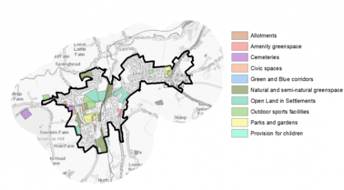
5.22.34 There are 36 open space sites of various types within the settlement which cover a total area of 33.1ha. The key open spaces sites in Haworth include Central Park, Cross Roads Park, Rawdon Road Allotments and Mytholmes Lane Fields. The priority should be for new outdoor sports open space such as playing fields and some improvements to the existing parks. Figure 4 shows the location and type of open space in the settlement.
Figure 4: Haworth – Open Space Overview
5.22.35 Haworth lies in the Worth Valley with the River Worth running east to west to the north of Haworth and Bridgehouse Beck running north to south through the centre of the settlement. The low lying areas around these watercourses could suffer from fluvial flooding and are in Flood Zone 2. There are other parts of the settlement, particularly along roads where there is potential for surface water flooding to occur due to the topography and permeability of surfaces in that area.
Community Infrastructure – Education, Health and Utilities
5.22.36 There are a number of community uses around the centre, including two churches and a village hall. Due to its popularity with tourists Haworth, has a high number leisure services units available to the community including numerous public houses, cafes, hotels and restaurants. There is also the Bronte Museum at the Parsonage.
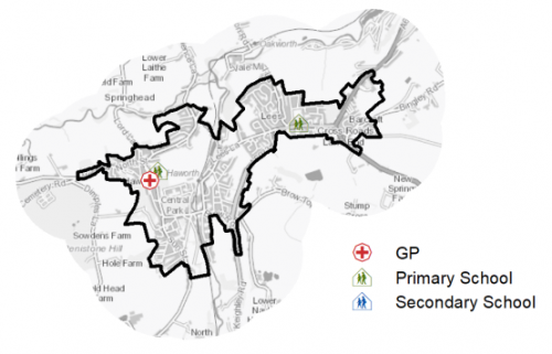
5.22.37 There are two primary schools within Haworth; Lees Primary school and Haworth Primary School. Lees Primary School is located on Haworth Road in the Cross Roads area which is to the east of Haworth centre; it has capacity for 210 students. Haworth Primary School is located on Rawdon Road to the north of the settlement; it has capacity for 341 students. Treetops children's centre is attached to Haworth Primary School and provides support and activities for primarily under-fives.
5.22.38 There is no secondary education setting within Haworth. The nearest secondary schools are Beckfoot Oakbank located on Oakworth Road, to the south of Keighley, with a capacity of 1,800 and Parkside School in Cullingworth, which has a capacity of 1,113.
5.22.39 The village is served by Haworth Medical Practice, which provides a service to residents of Haworth, Cross Roads, Stanbury and parts of Oakworth, it has around 9,300 patients. There is a pharmacy located within the settlement. Secondary (acute) healthcare is provided at Bradford Royal Infirmary and Airedale General Hospital. Figure 5 shows the location of local facilities.
Figure 5: Haworth – Schools and GP Practices
5.22.40 When planning for the long-term development of Haworth, it is vital that new development is supported by the appropriate infrastructure. The capacity, quality and accessibility of services and facilities are all key components in ensuring people can enjoy living, working and visiting the area. The council will continue work with key infrastructure providers and others including the Local Education Authority, Clinical Commissioning Group and utilities providers to determine the impacts of future growth and development on local infrastructure capacity and provision. Further infrastructure details will be published through the Local Infrastructure Plan and as part of the Regulation 19 stage of the local plan.
|
Local Area Strategy and Plan – Haworth The key elements of the local area strategy for Haworth include:
Conserve and enhance the designated and undesignated heritage of Haworth especially those elements which make a significant contribution to the distinct character of this area and the buildings and landscapes associated with the Brontes.
|

(19) Consultation Question 130
Haworth Local Area Strategy
The Local Plan sets out a local area strategy for Haworth.
Q. Please provide any comments you may have on the area strategy?
If you have an alternative to the approach undertaken, please provide further details and evidence in support.
Preferred Site Allocations and Site Pro Formas
5.22.41 The preferred housing site allocation is detailed below in Table A. This table is subsequently followed by site pro forma providing a summary of key site information and characteristics.
Table A: Housing - Preferred Allocation
|
Site Ref |
Site Name |
Dwellings |
|
HA1/H |
Worstead Road, Cross Roads |
70 |
|
HA2/H |
Lees Lane, Cross Roads |
27 |
|
HA3/H |
Lees Lane, Cross Roads |
30 |
|
HA4/H |
Ebor Mills, Ebor Lane |
38 |
|
HA5/H |
Ashlar Close |
5 |
|
HA6/H |
Ivy Bank Lane |
34 |
|
Total |
204 |
(10) Consultation Question 131
Haworth Site Allocations and Site Pro Formas
The Local Plan sets out preferred site allocations for Haworth. If you wish to make representations on the sites proposed, please provide feedback under this question.
If you wish to propose an additional or alternative site(s) to the preferred allocation listed, please also provide a plan with a red line and any further details in support.
[1] Universal Service Obligation (USO) - download speeds at or above 10Mbit/s and upload speeds at or above 1Mbit/s including non-matched records and zero predicted speeds
(14) HA1/H - Worstead Road, Cross Roads
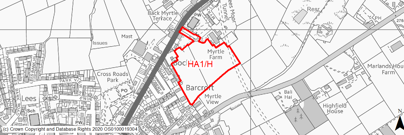
Site location
Local Service Centre - Haworth
Ward
Worth Valley Ward
Site description
The site contains steeply sloping fields with mature trees across the boundary. Good access is available on to Halifax Road via Worstead Road. A former railway tunnel passes under the eastern edge of the site.
Proposed Allocation
Housing
SHLAA referencce
HA/001
Indicative no. dwellings
70
Site area (Gross) (ha)
2.85
Ownership
Private
Delivery timescales
Developable (11-15 years)
Type (PDL/Greenfield)
Greenfield
Green Belt
No
Flood Zone
Flood Zone 1
Potential site access
Access from Worstead Road. Some reconfiguration maybe necessary to provide splays. Access of busy Halifax Road. Site can be accessed from the A629 via Worsted Road.
Public Transport Accessibility
Bus stop adjacent site with good service 3 or 4 an hour.
Sustainability Appraisal
No significant adverse effects predicted for the site. Minor adverse effects have been predicted for most natural environment themed SA Objectives, primarily as a result of the site being a large greenfield site containing GI elements. The site would provide residents with good access to buses, cultural spaces, schools and health facilities, but access to some key services and employment areas is somewhat limited.
Habitats Regulations Assessment
This site falls within 7km of the South Pennine Moors SPA/SAC. A HRA must be undertaken to ensure there are no significant effects on these protected sites. Developments within these zones must comply with Policy SP11; a SPD is being produced to provide further guidance.
Green Belt
N/A – Site not within the Green Belt.
Constraints and Opportunities
• Site slopes quite steeply south to north.
• Development of the site would have a high impact on the landscape.
• Within the Worth Valley Green Infrastructure Corridor.
• The site is located within the 2.5km buffer of the SPA/SAC.
• Sustainable location within the settlement.
• A former railway tunnel passes under the eastern edge of the site.
Development considerations
• Topography would require some leveling or terraces. Due to the site's topography, a highly sensitive site design will be required to mitigate any impact on the surrounding landscape and Green Infrastructure corridor.
• Access can be taken from Worstead Road, some reconfiguration maybe necessary to provide splays.
• Whilst not subject to TPOs, the mature trees in the centre of the site should be retained.
Conclusion/Summary
This is a sloping site which is sustainably located within the settlement boundary and near to local services and facilities, including a primary school and open space. It would deliver an estimated 70 dwellings and additional open space provision.
(19) HA2/H - Lees Lane, Cross Roads
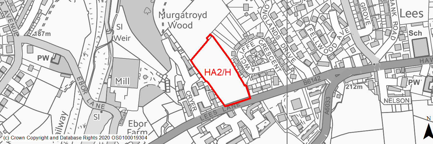
Site location
Local Service Centre - Haworth
Ward
Worth Valley Ward
Site description
Sloping unmaintained fields with group of trees on the southern boundary. Site can be accessed from neighbouring Cryer Meadows estate.
Proposed Allocation
Housing
SHLAA referencce
HA/003
Indicative no. dwellings
27
Site area (Gross) (ha)
0.87
Ownership
Private
Delivery timescales
Developable (6-10 years)
Type (PDL/Greenfield)
Greenfield
Green Belt
No
Flood Zone
Flood Zone 1
Potential site access
Access in former permission was taken from new estate on Cryer Meadows. Potential access from Lees Lane also though TPOs.
Public Transport Accessibility
Bus stop adjacent site with good service 3 or 4 an hour.
Sustainability Appraisal
No significant adverse effects predicted for the site. Minor adverse effects predicted for most natural environment themed SA Objectives, primarily as a result of effects associated with new development on a large greenfield site. The site generally offers good access to keys services and amenities, including shops, jobs and buses, but is not within the target distance of all and no major positive effects have been predicted.
Habitats Regulations Assessment
The majority of this site falls within 2.5km of the South Pennine Moors SPA/SAC a HRA must be undertaken to ensure there are no significant effects on these protected sites in terms of impact on supporting habitat which might be functionally linked to the SPA and recreational pressures. Developments within these zones must comply with Policy SP11; an SPD is being produced to provide further guidance.
Green Belt
N/A – Site not within the Green Belt.
Constraints and Opportunities
• Within the Worth Valley Green Infrastructure Corridor.
• Undulating, prominent hillside site mostly sloping east to west but with a dipped basin in south-east corner.
• The two blanket TPOs along south of site.
• The site is located within the 2.5km buffer of the SPA/SAC.
• Development of the site would have a low impact on the landscape.
• Sustainable location within the settlement.
Development considerations
• Trees covered by the two TPOs along south of site to be retained by taking access from Cryer Meadows.
• Topography would require some leveling or terraces. Due to the site's topography, a sensitive site design will be required to mitigate any impact on the surrounding landscape and Green Infrastructure corridor.
• The topography along with small areas of surface water flooding would require a considered drainage strategy.
Conclusion/Summary
This site is sustainably located within the settlement boundary and near to local services and facilities, including a primary school and open space. It would deliver an estimated 33 dwellings and additional open space provision.
(22) HA3/H - Lees Lane, Cross Roads

Site location
Local Service Centre - Haworth
Ward
Worth Valley Ward
Site description
Unused sloping field to rear of new homes and enclosed to north west by mature woodland. Access available form the Cryer Meadows estate. Allocated as Village greenspace in RUDP.
Proposed Allocation
Housing
SHLAA referencce
HA/004
Indicative no. dwellings
30
Site area (Gross) (ha)
0.97
Ownership
Private
Delivery timescales
Developable (6-15 years)
Type (PDL/Greenfield)
Greenfield
Green Belt
No
Flood Zone
Flood Zone 1
Potential site access
Access available off Midgley Drive, part of the Cryer Meadows estate.
Public Transport Accessibility
Bus stop with good service within 400m.
Sustainability Appraisal
No major effects, either positive or negative, on any SA Objective have been predicted for the site.
Minor positive effects were predicted for nearly all socio-economic themed SA Objectives due to the benefits of new residential development for the local economy as well as the location of the site in relation to transport links, local services and amenities, health and education facilities and employment areas.
Minor adverse effects were predicted for a range of natural environment themed SA Objectives, primarily as a result of the impacts of new development on a 100% greenfield site containing trees and adjacent to TPO woodland.
Habitats Regulations Assessment
Half of this site falls within 2.5km of the South Pennine Moors SPA/SAC a HRA must be undertaken to ensure there are no significant effects on these protected sites in terms of impact on supporting habitat which might be functionally linked to the SPA and recreational pressures. Developments within these zones must comply with Policy SP11; an SPD is being produced to provide further guidance.
Green Belt
N/A – Site not within the Green Belt.
Constraints and Opportunities
• Within the Worth Valley Green Infrastructure Corridor.
• Moderate slope.
• Designated as Open Land In Settlements the RUDP.
• Development of the site would have a moderate impact on the landscape.
• The site is located within the 2.5km buffer of the SPA/SAC.
• Sustainable location within the settlement.
Development considerations
• Access in former permission was taken from new estate on Cryer Meadows however access may also be provided through the development of HA2/H.
• Topography would require some leveling or terraces.
• Whilst the site is designated as Village Greenspace in the RUDP, it has already been compromised and split by the Cryer Meadows/Midgley Drive development and no longer fulfils its purpose as part of a green swathe.
• Views across the valley to this site may be screened by woodland, enhancement of the woodland edge twould be required.
• A sensitive site design will be required to mitigate any impact on the surrounding landscape and Green Infrastructure corridor.
Conclusion/Summary
This site is sustainably located within the settlement boundary and near to local services and facilities, including a primary school and open space. It would deliver an estimated 30 dwellings and additional open space provision, it may come forward as a joint development with HA2/H.
(7) HA4/H - Ebor Mills, Ebor Lane
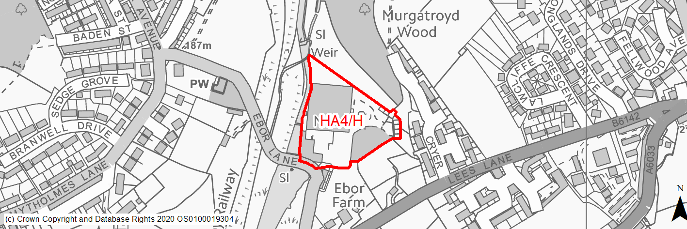
Site location
Local Service Centre - Haworth
Ward
Worth Valley Ward
Site description
Former mill located off Ebor Lane in a wooded valley, adjacent the heritage railway and Bridgehouse Beck. The mill suffered fire damage causing a number of the buildings to be demolished, some Mill buildings remain in partial use. Many of the existing mill buildings are grade II listed, the chimney is a prominant feature of the Haworth landscape despite the mill's position, nestled in the valley.
Proposed Allocation
Housing
SHLAA referencce
HA/005
Indicative no. dwellings
38
Site area (Gross) (ha)
1.18
Ownership
Private
Delivery timescales
Deliverable/Developable (0-10 years)
Type (PDL/Greenfield)
PDL
Green Belt
No
Flood Zone
Flood Zone 1
Potential site access
Access from Ebor Lane, narrow lane on a tight bend with limited visability. Improvement may be required.
Public Transport Accessibility
Bus stop adjacent site with good service 3 or 4 an hour.
Sustainability Appraisal
No significant adverse effects predicted for the site.
As a PDL plot with some vacant industrial buildings, development here could be an opportunity to deliver biodiversity net gains and improvements to the local character and setting. It would be a highly efficient use of the land resource. The site would provide residents with generally good access to services and amenities, including jobs, shops, cultural spaces and schools, with particularly good access to health facilities. The only minor adverse effects predicted for the site are related to surface water flood risk within the site, as well as potential effects on the nearby Bridgehouse Beck watercourse and (as with all sites) a minor increase in air pollution and water consumption at this location in relation to existing levels.
Habitats Regulations Assessment
This site falls within 2.5km of the South Pennine Moors SPA/SAC a HRA must be undertaken to ensure there are no significant effects on these protected sites in terms of impact on supporting habitat which might be functionally linked to the SPA and recreational pressures. Developments within these zones must comply with Policy SP11; an SPD is being produced to provide further guidance.
Green Belt
N/A – Site not within the Green Belt.
Constraints and Opportunities
• The site contains Grade II listed Ebor Mills, several listed structures remain on site, it is also within 50m of several other Listed Buildings Grade II.
• Designated in the RUDP as Open Land in Settlements.
• Within the Worth Valley Green Infrastructure Corridor.
• The site is located within the 2.5km buffer of the SPA/SAC.
• Local Wildlife Site to the south of site. Sustainable location within the settlement.
• Development of the site would have a low impact on the landscape.
Development considerations
• Buildings require a long term sustaining use and construction of a complementary built form to replace demolished mill.
• Heritage and ecological concerns are currently being reviewed in planning application process.
• Earthworks and remediation of the site will be required to establish appropriate development areas.
• A sensitive site design will be required to mitigate any impact on the listed buildings, Green Infrastructure corridor and the wider landscape.
• Direct vehicular and pedestrian access off Ebor Lane, narrow lane on a tight bend with limited visability, improvement may be required.
Conclusion/Summary
Current planning application for conversion and refurbishment of Ebor Mills into 14 dwellings, and construction of 24 new dwellings within the curtilage of the site is well developed and site may have planning permission in the near future, in which case this will be a commitment rather than allocation.
(3) HA5/H - Ashlar Close
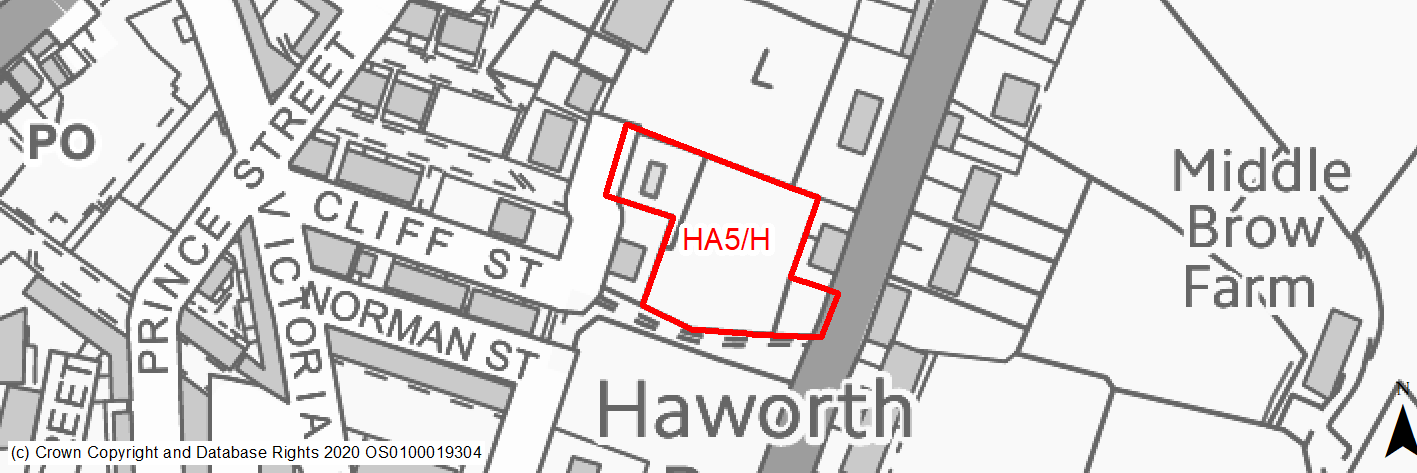
Site location
Local Service Centre - Haworth
Ward
Worth Valley Ward
Site description
Two slightly sloping fields in full use as bird and animal pens- sheep chickens and geese. Stone building and many huts exist on site which is divided by wire and wooden fencing. Access could be taken from Ashlar Close.
Proposed Allocation
Housing
SHLAA referencce
HA/008
Indicative no. dwellings
5
Site area (Gross) (ha)
0.29
Ownership
Private
Delivery timescales
Developable (6-10 years)
Type (PDL/Greenfield)
Greenfield
Green Belt
No
Flood Zone
Flood Zone 1
Potential site access
Access from Cliff Street / Ashlar Court for small development would be acceptable.
Public Transport Accessibility
Bus stop adjacent site with good service 3 or 4 an hour.
Sustainability Appraisal
The site could deliver a major positive effect for residents on the health SA Objective as a result of being within the target distances for all necessary health facilities.
Minor positive effects were predicted for nearly all other socio-economic themed SA Objectives due to the benefits of new residential development for the local economy, as well as the location of the site in relation to transport links, local services and amenities, education facilities and employment areas.
As a predominantly greenfield site containing trees which would be lost in the development, but minor adverse effects have been predicted for the site for a range of natural environment themed SA Objectives.
Habitats Regulations Assessment
This site falls within 2.5km of the South Pennine Moors SPA/SAC a HRA must be undertaken to ensure there are no significant effects on these protected sites in terms of impact on supporting habitat which might be functionally linked to the SPA and recreational pressures. Developments within these zones must comply with Policy SP11; an SPD is being produced to provide further guidance.
Green Belt
N/A – Site not within the Green Belt.
Constraints and Opportunities
• Within the Worth Valley Green Infrastructure Corridor.
• Fairly steep slope with potential for development.
• Development of the site would have a moderate impact on the landscape.
• Retaining wall at top.
• The site is located within the 2.5km buffer of the SPA/SAC.
• Sustainable location within the settlement.
Development considerations
• Topography would require some leveling or terraces.
• Due to the site's topography, a sensitive site design will be required to mitigate any impact on the surrounding landscape and Green Infrastructure corridor.
• Access can be taken from Ashlar Close.
Conclusion/Summary
This site is sustainably located within the settlement boundary and near to local services and facilities, including a primary school and open space. It would deliver an estimated 6 dwellings.
(8) HA6/H - Ivy Bank Lane

Site location
Local Service Centre - Haworth
Ward
Worth Valley Ward
Site description
Former textile mill site situated in the bottom of the valley, inbetween Ivy Bank Lane and the heritage railway / Bridgehouse Beck. The site is somewhat overgrown but contans remenants of derelict buildings and overgrown allotments. The site was formerly accesed from Ivy Bank Lane however there is steep change in levels at the former acces point. The site is within a Conservation Area and contains priority habitat.
Proposed Allocation
Housing
SHLAA referencce
HA/010
Indicative no. dwellings
34
Site area (Gross) (ha)
1.16
Ownership
Private
Delivery timescales
Deliverable (0-5 years)
Type (PDL/Greenfield)
PDL
Green Belt
No
Flood Zone
Flood Zone 1
Potential site access
Ivy Bank Lane, access would require improvements. Previous schemes have been approved in lapsed planning permissions. Access to site is poor and needs improving. In addition to the pending application 18/03530/MAO, other earlier applications have been approved and all require significant highway improvements to link the site to the external highway.
Public Transport Accessibility
Bus stop adjacent site with good service 3 or 4 an hour.
Sustainability Appraisal
No significant adverse effects predicted for the site. Minor adverse effects predicted for most natural environment themed SA Objectives, primarily as a result of the effects associated with development on greenfield and greened over PDL, with TPO woodland and Priority Habitat adjacent to and within the Site. Site falls within the Natural England SSSI Risk Zone for South Pennine SSSI for any application of 50 or more dwellings, which is currently not expected to be the case.
The site is in proximity to various heritage assets, including several Grade II Listed Buildings, Central Park Registered Park/Garden, the heritage railway adjacent to the site’s eastern perimeter, and is also within the Haworth Conservation Area. Development would be likely to have a minor adverse effect on the local setting, to some extent, but would be within an area of similar built form.
The site would provide residents here with good access to key services and amenities, including shops, cultural spaces, jobs and schools, with particularly good access to health facilities.
Habitats Regulations Assessment
This site falls within 2.5km of the South Pennine Moors SPA/SAC a HRA must be undertaken to ensure there are no significant effects on these protected sites in terms of impact on supporting habitat which might be functionally linked to the SPA and recreational pressures. Developments within these zones must comply with Policy SP11; an SPD is being produced to provide further guidance.
Green Belt
N/A – Site not within the Green Belt.
Constraints and Opportunities
• Within Haworth Conservation Area.
• 50% Natural/semi-natural green space. 30% Semi-improved neutral grassland.
• Within water source protection zone 2.
• The site has some surface water flooding: an area of 1 in 30 in centre of site and a wider area of 1 in 100 crossing the site, approx 30% of site is 1 in 1,000 largely around the centre but some areas to north and south-west.
• Within the Worth Valley Green Infrastructure Corridor.
• The site is located within the 2.5km buffer of the SPA/SAC.
• Sustainable location within the settlement. Development of the site would have a low impact on the landscape.
Development considerations
• Sensitive development respecting Haworth conservation area's character and local identity is essential.
• Part of site is composed of priority woodland and this needs to be retained. Much of the rest of the site might also be of high wildlife value as 30% Semi-improved neutral grassland, full ecology surveys are required prior to allocation.
• Whilst it is a contained site, it is highly visible on rising land hence very sensitive and any development needs to complement the existing character of the village.
• Due to surface water flooding issues drainage would have to be carefully considered and sustainable systems and natural flood management incorporated into the design.
• Ivy Bank Lane, access would require improvements, other earlier applications have been approved and all required significant highway improvements to link the site to the external highway, since then there has been a quantum of developed and expected development in the area which will lead to increased traffic at the junction.
Conclusion/Summary
Whilst the site has constraints in terms of highways and access, ecology, heritage and surface water flooding it has previously benefitted from planning permission and is part way through a new outline planning application. It is a fairly level site which is sustainably located within the settlement boundary and near to local services and facilities, including a primary school and open space. It would deliver 34 dwellings.