
Draft Bradford District Local Plan - Preferred Options (Regulation 18) February 2021
Bingley
Introduction
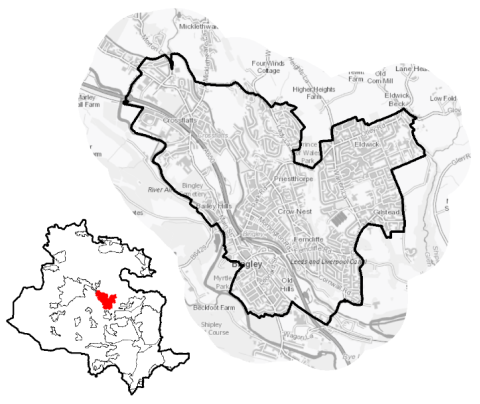
5.9.1 Bingley is the second largest settlement in the Airedale Sub Area. It is located close to the centre of the District occupying a point where the valley of River Aire narrows, some 9.7km to the north west of Bradford, 20km to the north west of Leeds and 8km to the east of Keighley. The settlement extends to the suburbs of Crossflatts in the north west, Eldwick in the north east, Gilstead in the east and Poplar House in the south. Bingley is attached to the settlement of Keighley (by ribbon development along the B6265 at Crossflatts) and Cottingley to the south east. The River Aire and the Leeds and Liverpool Canal run through the town. Its falls within Bingley Ward and the Shipley Parliamentary Constituency. Bingley Town Council acts as an administrative body for the parish area.
Figure 1: Location Map
5.9.2 Bingley is a market town, with a local employment base and good connections to nearby towns and cities including Bradford, Keighley, Leeds and Shipley. It acts as a service centre within the district, particularly for the surrounding villages including Micklethwaite, East Morton, Harden and Wilsden. The town includes a wide range of community services and facilities that support its role as well as the needs of the local population.
5.9.3 Bingley has a resident population of 17,835. It has a higher proportion of the population (23%) over the age of 65 compared to the West Yorkshire average (16.7%). The largest percentage (around 97%) of the population identify as being of White British ethnicity which is below the West Yorkshire average of 78.4%. Household composition is broadly similar to the sub-regional picture, with the largest number of households (34%) consisting of married households. The number of pensioner households (those aged over 65), it higher that than average at 23.2% compared with 19.5% within West Yorkshire.
5.9.4 The Town Council is working to prepare of a Neighbourhood Plan that will help to shape how Bingley and Cottingley will grow and develop in the coming years (up to 2030). It sets outs local priorities and policies that will be used, once adopted, as part of the statutory development plan to make decisions on planning applications in the town.
Planning for Prosperity
5.9.5 The Local Plan settlement hierarchy under Policy SP3 identifies Bingley as one of Bradford district's three principal towns. This means that it will be a main local focus growth for housing, employment, shopping, leisure, education, health and cultural activities and facilities.
5.9.6 Bingley generally ranks low in terms of overall deprivation. The exception is in living environment and crime which lie broadly on par with sub-regional averages of percentage of residents living in neighbourhoods ranked within the most deprived (20%) in England.
Figure 2: Indices of Multiple Deprivation
|
Number of people in Bingley Sub Area living in the most deprived 20% of areas of England by Indices of Deprivation (ID) 2019 domain |
||||||
|
Index of Multiple Deprivation |
Income domain |
Employment domain |
Education domain |
|||
|
797 |
797 |
797 |
0 |
|||
|
4.5% (West Yorkshire average = 36.2%) |
4.5% (West Yorkshire average = 31.9%) |
4.5% (West Yorkshire average = 32.4%) |
(West Yorkshire average = 35.3%) |
|||
|
Health domain |
Barriers to Housing and Services domain |
Living Environment domain |
Crime domain |
|||
|
2,756 |
0 |
6,920 |
7,794 |
|||
|
15.5% (West Yorkshire average = 33.8%) |
(West Yorkshire average = 1.8%) |
38.8% (West Yorkshire average = 39.8%) |
43.7% (West Yorkshire average = 48.2%) |
|||
|
Source: Ministry of Housing, Communities and Local Government (Indices of Deprivation 2019) |
||||||
Economy and Employment
5.9.7 Economic activity rates at 74.3% are above West Yorkshire average at 68.5%. This economically active population also comprises a higher proportion of full and part-time employees than the sub-regional average, and a higher percentage of self-employed people. Retail, education and health and social care are the top three employment sectors or Bingley residents, with a higher percentage of the workforce employed in managerial, professional and administrative occupations than the West Yorkshire average. The annual household income in Bingley at £44,549 is therefore higher than the West Yorkshire average of £38,499.
5.9.8 Bingley has a relatively strong employment base. This is due to its attractive surroundings, available workforce and accessibility as well as good transport connections. The town has around 700 businesses of varying types and scales that employ around 6,000 people. The largest employer is Computershare, with 900 employees. Other large employers include Damart, Emerald Publishing and UK Asset Resolution (UKAR). Business Register and Employment Survey (BRES) Register indicates that the largest industry sector is retail (at 16.7% of all people in employment), followed by finance (15.6%) and education (15%).
5.9.9 The main employment areas are located along the A650 Aire Valley trunk corridor, within and adjacent to the town centre and in the Crossflatts area (Castlefield Industrial Estate and Croft Road). A smaller business park is located on Dowley Gap Lane.
5.9.10 Policy SP6 sets a District employment land requirement of at least 72ha of open market employment land – use classes B2, B8 and E (formerly B1 type uses). It is expected that Bingley will make a contribution to employment land provision through the allocation of employment land at Castlefields Lane for general employment use and John Escritt Road for the extension of an existing business. The priority sectors within Airedale of manufacturing, logistics, professional and final services, and media sectors continue to be supported.
5.9.11 In order to meet the overall target for employment land provision and support the economic ambitions for the area, table A provides details of the preferred employment site allocations within Bingley. The preferred employment site allocations are also identified on the Policies Map and within site proformas, together with the local strategies map for each plan area.
Retail
5.9.12 Bingley is designated in the retail hierarchy (Policy EC4) as a town centre. It is roughly linear in character, focussing along Main Street and branching off along Chapel Walk and Myrtle Place. The Primary Shopping Area is defined as stretch of Main Street between Harden Road and Ferncliffe Road. The centre contains a small sized pedestrianised shopping mall, the Bingley Five Rise Centre. The Retail and Leisure Study 2019 concluded that Bingley is a healthy centre with below national average vacancy rates and a good quality environment, but could benefit from improved connectivity (particularly to the canal as a leisure attraction) and wider range of retail offer. The extent of the Town Centre boundary and Primary Shopping Area are shown on the Policies Map. Figure 3 below sets out the town centre boundary.
Figure 3: Bingley Town Centre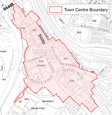
5.9.13 Crossflatts Local Centre is located at the junction of Keighley Road (B6265) and Micklethwaite Lane, approximately 2.5km to the north west of Bingley town centre. The boundary is shown on the Policy Map. It is considered to be a healthy local centre with an appropriate convenience for its size as well as a good level of services with the leisure offerings being particularly strong. Alongside the retail offerings, comprising mainly hairdressers, this provides the centre with strong day and night uses. The centre also benefits from there being no vacant units meaning the shopping experience is not weakened. The environmental quality was standard but could be improved to enhance the centre. Performing the improvements above would enhance the general aesthetics within the centre.
Transport and Access
5.9.14 Bingley has excellent transport connections (road and rail) to nearby major towns and cities due to its location within the key transport corridor running through the Aire Valley. The A650 Aire Valley trunk road passes through the town and providing the main road links to and from Bradford, Shipley and Keighley as well as to settlements in the north west of the district (Steeton with Eastburn and Silsden) and beyond into North Yorkshire and East Lancashire. The B6265 runs through the town centre connecting it with Cottingley, Crossflatts and Riddlesden. The B6429 links Bingley with Harden, Cullingworth and Wilsden, whilst a number of minor roads connect it to other settlements to the north and north east (East Morton, Menston and Baildon).
5.9.15 The town also has good public transport links. Bingley railway station is located in the town centre, whilst a second station is situated in Crossflatts. They provide frequent train services on the electrified Airedale line serving Bradford (Forster Square), Keighley, Leeds, Shipley and Skipton. Other less frequent services provide links from Bingley station beyond Skipton to Carlisle (via the Settle and Carlisle line) and Lancaster (via the Bentham Line). The town is also served by a network of high frequency bus services operated by First Bradford and the Keighley Bus Company that provide links north towards Eldwick (via Gilstead), south and east towards Bradford (via either Cottingley, Harden or Shipley) and Leeds (via Shipley), as well as west along the Aire Valley towards Keighley and Riddlesden (via Crossflatts). Other less frequent services run through Bingley town centre connecting Keighley and Cullingworth (via East Morton).
5.9.16 As noted previously, the Leeds and Liverpool Canal passes through Bingley. There are several flights of locks in the Bingley section, the famous Five Rise Locks, the smaller Three Rise and a further two lock flight at Dowley Gap. The canal climbs steeply up the side of the Aire valley through this section. The canal towpath serves as a busy walking and cycle route. It forms part of the Airedale Greenway and National Cycle Network route 696, which provides a link between Bingley, Saltaire, Shipley and Keighley and beyond via the wider network to Bradford and Leeds. Bingley is not covered by an Air Quality Management Area (AQMA) and lies outside the proposed Clean Air Zone (CAZ).
5.9.17 In terms of car ownership, Bingley has a slightly higher (28.2%) than West Yorkshire average percentage (22.6%) of two car households and lower levels of no car ownership (22.3% compared to 29.4%).
5.9.18 Ofcom digital connectivity data indicates that the average broadband download speeds in Keighley is just over 49.31 megabytes per second – above the West Yorkshire average (44.57), whilst there is only one premise where speeds are below the Universal Service Obligation (USO)[1]. Strategic transport infrastructure projects to be delivered within the plan period and protected routes are set out in table 1 below and on the Policies Map with the local plan.
Table 1: Bingley Transport Projects
|
Policies Map Ref. |
Project Name |
|
TR1.C.2 |
Bus Priority Corridor (Keighley Road/Bradford Road) |
|
TR1.A.5 |
Airedale Greenway (Leeds/Liverpool Canal) |
Planning for Homes
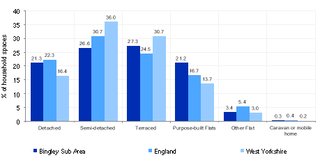
5.9.19 Bingley has 8,328 dwellings, which are split fairly evenly across dwelling types – 21.3% detached, 26.6% semi-detached, 27.3% terraced and 21.2% purpose built flats. Bingley is noticeable for having higher percentages of detached and flats than the West Yorkshire averages (16.4% and 13.7%). Figure 5 below provides further information.
Figure 5: Bingley – Dwelling Type Breakdown
5.9.20 Owner occupancy levels are higher in Bingley at 71.3% than the West Yorkshire average (63.1%), with higher levels of outright owned property at 33.4% compared to the national average at 28.8%. Bingley has a noticeable higher percentage of dwellings build after 2000 at 20.9% compared to the West Yorkshire average of 13.7%. The average house price (all dwellings) in Bingley is £191,533 which is slightly above the West Yorkshire average of £183,194 but well below the average in England of £304,430. The total affordability ratio between house prices and annual earnings which is usually used as a proxy for number of years' worth of earnings required for a house deposit is 3.37 compared to a West Yorkshire average of 2.96.
5.9.21 Delivering new housing is a key part of the overall development strategy for Bingley. It will ensure that the housing needs and aspirations of local people can be met, together with those of future residents, including the provision market and affordable housing. In addition, it will support the economy and town centre and reflect its role as a Principal Town. The local housing market in Bingley is reasonably diverse and new housing should continue to deliver a wide range of housing options for local people. Policy SP8 sets out a requirement of 850 dwellings that will be delivered in Bingley during the plan period. These will be delivered through a mix of committed sites (those under construction or have planning permission but have not yet commenced) and allocations. Table 2 below sets out the housing position for Bingley, which also includes the application of non-implementation or discount rates for planning permissions and allocations.
Table 2: Bingley - Summary of Housing Requirement and Supply
|
Housing Target |
850 units |
|
Carried Forward Commitments |
163 |
|
Commitment Discounted by 10% |
147 |
|
Remaining Allocation Requirement |
703 |
|
Identified Allocations |
781 |
|
Allocations Discounted by 10% |
703 |
|
Total Supply Contribution from Allocations |
703 |
5.9.22 Once the commitments are discounted and removed from the supply this leaves a residual allocation requirement of 703 units. The evaluated total site supply of housing units from preferred allocation sites equates to 781 units which is in turn discounted by 10% for non-implementation leaving a final allocation contribution of 703 units across all sites. The Council will be supportive of additional proposals for new homes on additional small sites, particularly those that provide a redevelopment opportunity to bring forward land which has been previously used. Support will also be provided to developers who wish to redevelop larger sites and/or buildings for new homes not currently identified, subject to all relevant policies in the Local
5.9.23 Bingley's allocation mix includes three brownfield sites, one greenfield site within the settlement and three small scale Green Belt release site which together meet the housing requirement for the town over the plan period. In delivering the target for new homes in Bingley it has been necessary to make some changes to the adopted green belt. Policy SP5 sets out The Councils approach and justification for green belt releases to accommodate new development and lists the sites proposed for allocation which current lie within or partly within the green belt.
5.9.24 The new local plan preferred site allocations for residential allocations to meet Bingley's housing requirement are set out in Table B and identified on the Policies Map and the Site Pro formas together with the local strategies map for each plan area. Development of site allocations should be in accordance with specified development guidelines and approximate site provision figures and all other relevant policies of this Local Plan.
Planning for Places and Communities
Green Belt, Natural Landscape and Historic Character
5.9.25 Bingley is surrounded by Green Belt; this land that surrounds the urban area of Bingley falls within the Airedale Landscape Character Area to the north and the Wilsden Character Area to the south west. The character of large parts to the north, south-east and west has been identified as being very sensitive to any form of development, with land to the south of the railway line being of low sensitivity
5.9.26 There are four Conservation Areas in Bingley - Bingley Town Centre that covers the oldest surviving part of the town, incorporating the parish church and the remains of the early highway (now Old Main Street), the Leeds and Liverpool Canal which cuts through the centre of the town, Eldwick Beck on the north eastern edge, and Micklethwaite, situated to the north of the town. There are a total of 77 Listed Buildings within the town, the majority of which are Grade II Listed. There is one Grade I Listed Building/Structure – Five Rise Locks. Two further structures associated with the Leeds and Liverpool Canal which are Grade II* Listed (Two Rise Locks and Three Rise Locks).
5.9.27 Other Grade II* Listed Buildings/Structures include Church of All Saints, Gawthorpe Hall, Ireland Bridge and Ryshworth Hall. One Scheduled Monument is found within the built up area in Crosley Wood. Additional heritage designations include Prince of Wales Park and the St Ives Estate which are designated as Historic Parks and Gardens. Milner Field in Gilstead is recognised as a local historic site. Additionally, land immediately east of Bingley falls within the Saltaire World Heritage Site Buffer Zone.
Green Infrastructure, Ecology, Open Space and Flood Risk
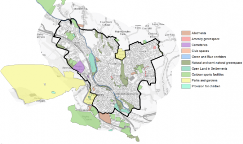
5.9.28 The town has a range of corridors and spaces that contribute towards its Green and Blue Infrastructure network. Key corridors include the valley of the River Aire as well as Shipley Glen to the east. These are identified below in Figure 6.
Figure 6: Green Infrastructure Corridors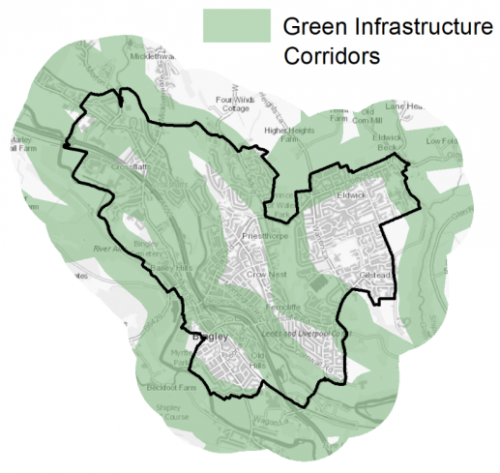
5.9.29 There are a number of biodiversity designations which lie within Bingley or adjoin the main urban area in the form of a Site of Special Scientific Interest (SSSI) and Local Wildlife Sites (LWS). The Bingley South Bog SSSI is located to the south east of the town centre and close to the A650 Aire Valley Trunk Road. The Leeds and Liverpool LWS runs through the town centre, whilst the Gilstead Moor and Prince of Wales Park LWS provide a corridor running north/south between Bingley and Eldwick. Bingley North Bog LWS lies between the A650 and the Leeds & Liverpool Canal and provides a natural habitat and informal open space. Other sites adjacent to the settlement include the St Ives Estate LWS, Hollin Plantation LWS, Ewe Hills LWS and Harden Beck LWS to the west and south west, and Shipley Glen LWS to the east.
5.9.30 In addition, there are 73 open space sites, totalling around 305ha of land within the Bingley area. These include the key sites of the St Ives Estate (Country Park), Myrtle Park, Prince of Wales Park, Bingley Cemetery and the Leeds & Liverpool Canal, alongside the woodlands and pathways of Milnerfield. Bingley has good levels of provision of nearly all open space typologies.
Figure 7: Bingley Open Space Overview
5.9.31 Bingley's location on the valleys of three watercourses means that parts of the area are liable for flooding – particularly within proximity to the River Aire corridor to the west and south of the settlement.
Community Infrastructure – Education, Health and Utilities
5.9.32 Bingley has a wide range of services which support the population including 11 Places of Worship (Churches), 3 Post Offices (Bingley, Eldwick & Gilstead), a library, Bingley Arts Centre (including Bingley Little Theatre), Bingley Swimming Pool, 4 Community Halls/Centres, a Petrol Station, Fire Station and numerous Public Houses
5.9.33 Bingley is served by six primary schools - Beckfoot Priestthorpe Primary, Crossflatts Primary, Eldwick Primary, Myrtle Park Primary, St. Joseph's Catholic Primary and Trinity All Saints Church of England Primary. They have the capacity to accommodate 2,110 pupils. Most of these schools currently have surplus places. The secondary schools that serve the town are Beckfoot School, Bingley Grammar School and Dixon's Cottingley Academy. They have the capacity to accommodate to 3,788 pupils.
5.9.34 Bingley Grammar School was founded in the 16th century and is one of the oldest schools in the country. Beckfoot and Bingley Grammar also have 6th form provision. In addition, local people have the opportunity to access post 16 education at several nearby Further Education colleges – Bradford College, Keighley College and Shipley College, whilst universities in Bradford and Leeds are also within reach.
5.9.35 Pupils attainment levels at Key Stage 1 was slightly above England and West Yorkshire average point scores and is broadly on par with national scores for Key Stage 2. Key stage 4 (GCSE) is above the West Yorkshire and national (England) average scores – 409.7 compared to 355.3 and 366.3 respectively.
5.9.36 The town and its suburbs are served by three medical facilities. These are the Eldwick & Gilstead Health Centre and the Canalside Healthcare Centre as well as Crossflatts surgery. The first is home to the Oak Glen Surgery, whilst the second hosts two medical practices (Bingley Medical Practice and Springfield Surgery), whilst the third is a branch surgery of the Bingley Medical Practice. These facilities between them have 23 GPs and 25,000 registered patients. Their catchment areas include Bingley, Cottingley, Crossflatts, East Morton, Eldwick, Gilstead, Harden, Micklethwaite, Nab Wood, Riddlesden, Sandbeds and West Morton. Secondary (acute) healthcare is provided at Bradford Royal Infirmary and Airedale General Hospital. In addition, there are five pharmacies and six dental clinics/surgeries. Figure 8 shows the location of exiting local services.
5.9.37 Average life expectancy for Bingley residents is 80 for men and 84 for women, which is slightly above the West Yorkshire and England averages. Healthy life expectancy is 67 and 69 for women which again is above national (England) and West Yorkshire figures.
Figure 8: Schools & Medical Facilities in Bingley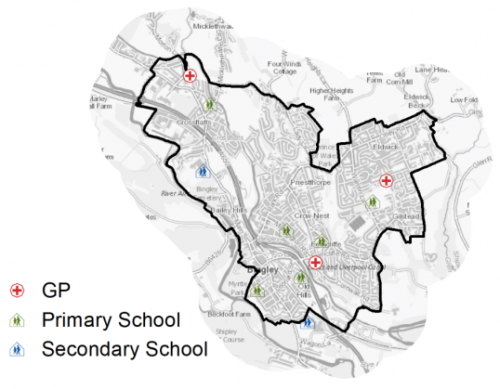
5.9.38 When planning for the long-term development of Bingley, it is vital that new development is supported by the appropriate infrastructure. The capacity, quality and accessibility of services and facilities are all key components in ensuring people can enjoy living, working and visiting the area. The council will continue work with key infrastructure providers and others including the Local Education Authority, Clinical Commissioning Group and utilities providers to determine the impacts of future growth and development on local infrastructure capacity and provision. Further infrastructure details will be published through the Local Infrastructure Plan and as part of the Regulation 19 stage of the local plan.
|
Local Area Strategy and Plan - Bingley |
|
The key elements of the local area strategy for Bingley include:
|

(17) Consultation Question 100
Bingley Local Area Strategy
The Local Plan sets out a local area strategy for Bingley.
Q. Please provide any comments you may have on the area strategy?
If you have an alternative to the approaches undertaken, please provide further details and evidence in support.
Preferred Site Allocations and Site Pro Formas
5.9.39 The preferred site allocations for Bingley for both employment and housing are detailed below in Tables A and B. These tables are subsequently followed by site pro formas for each preferred site allocation proving a summary of key site information and characteristics.
Table A: Bingley Employment Sites - Preferred Allocations
|
Site Ref |
Site Name |
Type |
Site Area (Gross Hectares) |
|
BI9/E |
Castlefields Road |
Vacant Brownfield |
1.18 |
|
BI10/E |
John Escritt Road |
Greenfield – Business Related |
0.5 |
|
Total |
1.68 |
Site BI10/E is not counted as contributing towards meeting general employment needs as is linked to the expansion of an existing business
Table B: Bingley Housing Sites - Preferred Allocations
|
Site Ref |
Site Name |
Dwellings / Other Uses |
|
BI1/H |
Coolgardie, Keighley Road |
135 |
|
BI2/HC |
Sty Lane |
440 |
|
BI3/H |
Greenhill Barn, Lady Lane |
25 |
|
BI4/H |
Heights Lane (West side) |
21 |
|
BI5/H |
Crosley Wood Road |
93 |
|
BI6/H |
Marley Court, Crossflatts |
19 |
|
BI7/H |
Whitley Street |
30 |
|
BI8/H |
Land west of Heights Lane |
18 |
|
Total |
781 |
Note: The site labelled "HC" had outline planning permission at 31st March 2020, whilst site BI6/H was the subject of a planning application which is now approved.
(13) Consultation Question 101
Bingley Site Allocations and Site Pro Formas
The Local Plan sets out a series of preferred site allocations. If you wish to make representations on any of the sites proposed, please provide site reference and feedback under this question.
If you wish to propose an additional or alternative site(s) to the preferred allocations listed, please also provide a plan with a red line and any further details in support.
[1] Universal Service Obligation (USO) - download speeds at or above 10Mbit/s and upload speeds at or above 1Mbit/s including non-matched records and zero predicted speeds
(3) BI9/E - Castlefields Road

Site location
Principal Town - Bingley
Ward
Bingley
Site description
Vacant brownfield site within industrial estate setting.
Proposed Allocation
Employment
SHLAA referencce
BI/064
Indicative no. dwellings
N/A
Site area (Gross) (ha)
1.18
Ownership
Private
Delivery timescales
2020-25
Type (PDL/Greenfield)
Brownfield - 100%
Green Belt
No
Flood Zone
Flood Zone 3 - close proximity to the River Aire.
Potential site access
Site can be accessed from existing industrial estate road.
Public Transport Accessibility
Bus Stop within 400m Frequent service / Within 800m of Rail Station
Sustainability Appraisal
See individual Sustainability Appraisal site comment in the accompanying report.
Habitats Regulations Assessment
This site falls within 7km of the South Pennine Moors SPA/SAC a HRA must be undertaken to ensure there are no significant effects on these protected sites. Developments within these zones must comply with Policy SP11; an SPD is being produced to provide further guidance.
Green Belt
N/A – Site not within the Green Belt.
Constraints and Opportunities
• Hedgerow along southern edge of the site.
• Identified in part as natural / semi-natural green space and partially within a GI corridor.
• Within SSSI impact zone.
• Surrounded by commercial and industrial land and premises on all sides - generally a level site.
• Site is situated within close proximity to River Aire and is classified as Flood Zone 3.
Development considerations
• Site can be accessed from existing industrial estate off Castlefields Road.
• Need to maintain a strong environmental buffer towards the River Aire and maximise GI and natural green space within the design with additional consideration of flood management.
• Buildings will need to be designed with flood resilience as a core principle.
Conclusion/Summary
Site is located within the popular Castlefield Industrial Estate and provides and opportunity to develop compatible employment uses within an established business location. Development detail will need to consider proximity and flood risk associated with the River Aire and integrating environmental assets within the scheme.
Use Class
Class B2/B8
(2) BI10/E - John Escritt Road

Site location
Pincipal Town - Bingley
Ward
Bingley
Site description
Greenfield site on a small industrial estate.
Proposed Allocation
Employment
SHLAA referencce
BI/057
Indicative no. dwellings
N/A
Site area (Gross) (ha)
0.5
Ownership
Private
Delivery timescales
2020-25
Type (PDL/Greenfield)
Greenfield - 100%
Green Belt
No
Flood Zone
Flood Zone 1 - low risk of flooding.
Potential site access
No major access constraints.
Public Transport Accessibility
Bus Stop within 400m Frequent service / Within 800m of Rail Station
Sustainability Appraisal
See individual Sustainability Appraisal site comment in the accompanying report.
Habitats Regulations Assessment
This site falls within 7km of the South Pennine Moors SPA/SAC a HRA must be undertaken to ensure there are no significant effects on these protected sites. Developments within these zones must comply with Policy SP11; an SPD is being produced to provide further guidance.
Green Belt
N/A – Site not within the Green Belt.
Constraints and Opportunities
• Site is under the ownership and within close proximity to James Walker (manufacturer) and may be suitable as an extension to this operations rather than as a more general open market industrial or employment use.
• Bingley South Bog SSSI immediately to the south together with hedgerow protection.
• Forms part of wider GI corridor.
• Eastern section of the site may require remediation due to previous works.
• Primary school to the north of the site which is also listed.
• Strong occupancy of nearby industrial units and within close proximity to the junction to the A650.
Development considerations
• Access off John Escritt Road.
• Strong environmental buffering required to the north and south of the site.
• Integration of GI as part of scheme design.
• Site considered to be only available at this stage for an expansion of existing operations of a nearby business.
Conclusion/Summary
Small scale employment site which may provide expansion space to an existing business. Scheme design will need to consider wider environmental considerations and link to GI network.
Use Class
Class B2/B8
(7) BI1/H - Coolgardie, Keighley Road, Crossflatts
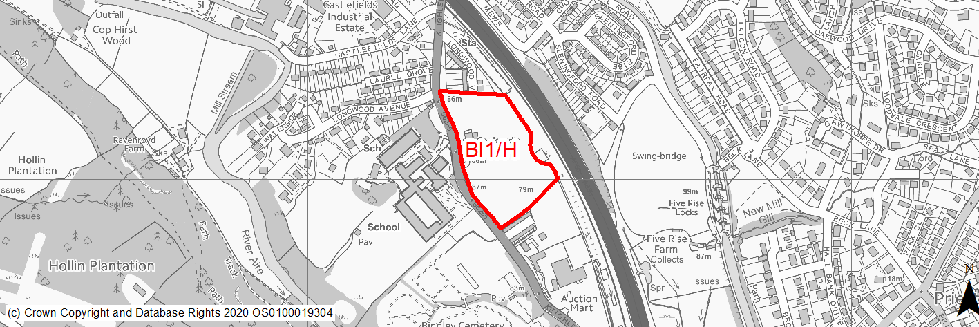
Site location
Principal Town - Bingley
Ward
Bingley
Site description
The site consists of agricultural land as well as sdsome derelict buildings adajcent to the western edge. It slopes downwards towards the Leeds/Bradford to Skipton railway line.
Proposed Allocation
Housing
SHLAA referencce
BI/005
Indicative no. dwellings
135
Site area (Gross) (ha)
2.99
Ownership
Private
Delivery timescales
Developable (6-10 years)
Type (PDL/Greenfield)
Greenfield
Green Belt
Not applicable
Flood Zone
Flood Zone 1 (22%), Flood Zone 2 (64%), Flood Zone 3a (14%)
Potential site access
Existing access to former farm buildings from Keighley Road.
Public Transport Accessibility
Bus: Nearest bus stops located adjacent to the south west corner and around 40m and 70m to the north west on Keighley Road. These stops 7/8 services per hour Bradford (6/7 per hour), Leeds (2 per hour) & Cullingworth (1 per hour) (all via Bingley) (southbound) and 8 services per hour to Keighley. Rail: Crossflats railway station is located adjacent to the north east corner of the site. It provides services to Keighley & Skipton (4 per hour), Leeds (2 per hour) and Bradford Forster Square (2 per hour).
Sustainability Appraisal
As a greenfield location, the site has been predicted to result in minor adverse effects on most natural environment themed SA Objectives. The eastern portion of the site coincides with Flood Zone 3a, while the majority of the site lies within Flood Zone 2, and so a careful layout of development would be required to avoid a significant effect on the flooding SA Objective. There are two Conservation Areas nearby, both within 200m, the setting of which could potentially be impacted upon.
The site offers excellent access to sustainable transport modes as well as health facilities. It is in proximity to important employment and economic areas. However, access to both primary and secondary state schools is somewhat limited due to the distance, although it is noted that there are grammar and private schools closer by.
Habitats Regulations Assessment
This site falls within 2.5km of the South Pennine Moors SPA/SAC a HRA must be undertaken to ensure there are no significant effects on these protected sites in terms of impact on supporting habitat which might be functionally linked to the SPA and recreational pressures. Developments within these zones must comply with Policy SP11; an SPD is being produced to provide further guidance.
Green Belt
N/A – Site not within the Green Belt.
Constraints and Opportunities
• This is a prominent greenfield site located within the built area up area of Bingley. It offers the opportunity to deliver residential development close to public transport (Crossflatts station) and the local highway network.
• Access can be taken from Keighley Road.
• The majority of the site is within Flood Zone 2 with some sections in Flood Zone 3a, whilst part of the site includes a former landfill.
• It is located within the 2.5km buffer of the SPA/SAC.
Development considerations
• Ecological survey to identify any impacts and mitigate accordingly.
• Flood risk assessment to determine extent of flood risk and identify appropriate mitigate.
• Mitigation through design to ensure development is located with the areas of lower flood risk.
• Contamination survery to determine any potential impacts and approproprite mitigation.
• Provision of high quality open space and landscaping to ensure development is compatible with the wider landscape.
• Provision of vehicular access from Keighley Road.
Conclusion/Summary
This site is situated in a sustainable location within an existing built up area and close to local facilities and services include public transport. It may be appropriate to develop a masterplan for the site to ensure that any design and layout is appropriate for the landscape and townscape. The site will deliver 135 dwellings.
(32) BI2/HC - Sty Lane
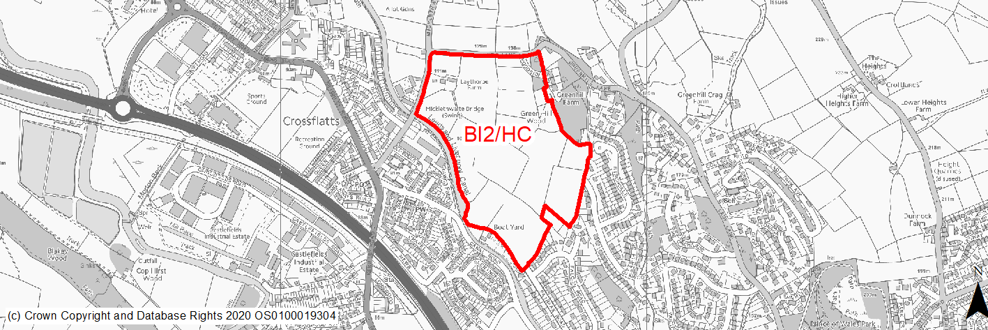
Site location
Principal Town - Bingley
Ward
Bingley
Site description
The site comprises agricultural land which sits within a wider agricultural landscape which extends north towards Micklethwaite. There is established residential development to the south of the site along Oakwood Drive and Fairfax Road. The site is separate from existing residential development in Crossflatts by the Leeds & Liverpool canal.
Proposed Allocation
Housing
SHLAA referencce
BI/008
Indicative no. dwellings
440
Site area (Gross) (ha)
16.61
Ownership
Private
Delivery timescales
Deliverable (0-5 years) and Developable (6-10 years)
Type (PDL/Greenfield)
Greenfield
Green Belt
No
Flood Zone
Flood Zone 1 (22%), Flood Zone 2 (64%), Flood Zone 3a (14%)
Potential site access
New accesses to be provided off Sty Lane, Micklethwaite Lane and limited access off Oakwood Drive.
Public Transport Accessibility
Public transport accessibility has been taken into account as part of the planning application process.
Sustainability Appraisal
As a large greenfield site containing trees and hedgerows, the development has been predicted to result in minor adverse effects on most natural environment themed SA Objectives. Additionally, consultation with Natural England would be required should there be residential development at the site of 50 dwellings or more, with regards to the potential effects on the South Pennine Moors SPAC/SAC/SSSI which is 1.3km north.
Being adjacent to the Leeds Liverpool Canal, careful consideration around protecting water quality would be required.
Consideration of the Leeds Liverpool Canal Conservation Area and a Grade II listed building which fall within the site boundary would be needed for the site’s planning application.
The site offers excellent access to healthcare facilities.
Minor positive effects were also predicted for most socio-economic themed SA Objectives due to the benefits of new residential development for the local economy as well as the location of the site in relation to transport links, educational facilities and employment areas.
Habitats Regulations Assessment
This site falls within 2.5km of the South Pennine Moors SPA/SAC a HRA must be undertaken to ensure there are no significant effects on these protected sites in terms of impact on supporting habitat which might be functionally linked to the SPA and recreational pressures. Developments within these zones must comply with Policy SP11; an SPD is being produced to provide further guidance.
Green Belt
N/A – Site not within the Green Belt.
Constraints and Opportunities
• Relevant constraints and opportunities have been considered as part of the planning application process.
Development considerations
• Relevant development considerations have been taken into account as part of the planning application process.
Conclusion/Summary
This site has outline planning permission for 440 dwellings (14/00293/MAO).
(32) BI3/H - Greenhill Barn, Lady Lane
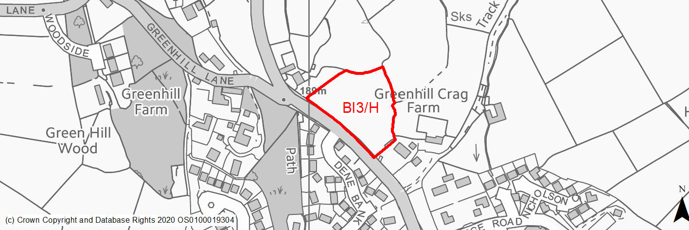
Site location
Principal Town - Bingley
Ward
Bingley
Site description
The site consists of an area of scrubland the majority of which is planted with conifer trees.
Proposed Allocation
Housing
SHLAA referencce
BI/011
Indicative no. dwellings
25
Site area (Gross) (ha)
0.79
Ownership
Private
Delivery timescales
Developable (6-10 years)
Type (PDL/Greenfield)
Greenfield
Green Belt
Green Belt
Flood Zone
Flood Zone 1
Potential site access
Existing field access onto Lady Lane.
Public Transport Accessibility
Bus: Nearest bus stop is more than 750m to the south of the site on Parkside. The site is not served by a bus route.
Sustainability Appraisal
As a large greenfield site within proximity to TPO and priority woodland habitat, the development has been predicted to result in minor adverse effects on most natural environment themed SA Objectives.
The loss of the greenfield site is also likely to have a negative impact upon the local landscape and townscape, particularly the two listed buildings within close proximity of the site.
The site’s access to transport links, services and educational facilities is somewhat limited.
Minor positive effects were predicted for most other socio-economic themed SA Objectives due to the benefits of new residential development for the local economy as well as the location of the site in relation to employment areas.
Habitats Regulations Assessment
This site falls within 2.5km of the South Pennine Moors SPA/SAC a HRA must be undertaken to ensure there are no significant effects on these protected sites in terms of impact on supporting habitat which might be functionally linked to the SPA and recreational pressures. Developments within these zones must comply with Policy SP11; an SPD is being produced to provide further guidance.
Green Belt
Based on planning judgement the site has a major potential impact on the Green Belt.
• The site is located in a moderate performing Green Belt parcel.
• The site makes a major contribution to the purposes of including land in the Green Belt.
• The site has major potential for sprawl and would have a major impact on openness.
• There are no features within the site which could be used to create a more logical or potentially stronger Green Belt boundary.
Constraints and Opportunities
• The site is currently designated as Green Belt, and the site specific Green Belt Assessment indicates that it has a major potential impact.
• An overhead electricity distribution line crosses the centre of the site and potential impact on the setting of Grade II Listed Building.
• Will require appropriate mitigation to reduce landscape impacts on the northern and eastern boundaries.
• It is with the 2.5km buffer of the SPA/SAC.
Development considerations
• Sensitive design to mitigate any impact of the setting nearby Grade II Listed Buildings.
• Suitably improved and designed access from Lady Lane is required.
• Bird survey due to proximity to SPA/SAC.
• Mitigation to reduce landscape impacts on the northern and eastern boundaries.
• Electricity distribution line.
Conclusion/Summary
This site is sustainably located adjacent to the settlement boundary for Bingley and provides suitable, small scale extension to the built up area. It is well screened to the west. It would deliver an estimated 25 dwellings.
(197) BI4/H - Heights Lane (west side), Eldwick
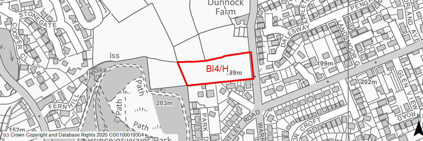
Site location
Principal Town - Bingley
Ward
Bingley
Site description
The site consists of a level field backing onto an area of woodland and Prince of Wales Park.
Proposed Allocation
Housing
SHLAA referencce
BI/013a
Indicative no. dwellings
21
Site area (Gross) (ha)
0.78
Ownership
Private
Delivery timescales
Developable (6 to 10 years)
Type (PDL/Greenfield)
Greenfield
Green Belt
Green Belt
Flood Zone
Flood Zone 2
Potential site access
Existing field access onto Heights Lane located at north east corner of the site.
Public Transport Accessibility
Bus: Nearest bus stops located around 100m to the south west of the site on Otley Road. These provide 2 services per hour in each direction to Eldwick and Bradford (via Bingley).
Rail: Bingley station is around 1.4km (straight line)/1.8km (via quickest walking route) to the south west of site.
Sustainability Appraisal
The south-western corner of the site adjoins the Prince of Wales Registered Park. New development at BI/013 could potentially alter the setting of this highly sensitive heritage asset. As a large greenfield and Green Bbelt site adjacent to a LWS and priority habitat, the development has been predicted to result in minor adverse effects on most natural environment themed SA Objectives.
The loss of the greenfield site is also likely to have a negative impact upon the local landscape and townscape, particularly the Prince of Wales Park (a Registered Park/Garden) which the adjoins the south-west corner of the site.
The site offers excellent access to healthcare facilities. Minor positive effects were also predicted for most socio-economic themed SA Objectives due to the benefits of new residential development for the local economy as well as the location of the site in relation to transport links, educational facilities and employment areas.
Habitats Regulations Assessment
This site falls within 2.5km of the South Pennine Moors SPA/SAC a HRA must be undertaken to ensure there are no significant effects on these protected sites in terms of impact on supporting habitat which might be functionally linked to the SPA and recreational pressures. Developments within these zones must comply with Policy SP11; an SPD is being produced to provide further guidance.
Green Belt
Based on planning judgement the site has a moderate potential impact on the Green Belt.
• The site is located in a moderate performing Green Belt parcel.
• The site makes a major contribution to the purposes of including land in the Green Belt.
• The site has a major potential for sprawl and would have a moderate impact on the openness.
• The site does not present an opportunity to create a stronger boundary than that of the existing one.
Constraints and Opportunities
• The site is currently designated as Green Belt, and the site specific Green Belt Assessment indicates that it has a moderate potential impact.
• It is close to a Local Wildlife Site and Listed Park (Prince of Wales Park), with the potential to impact on their settings.
• Also within the 2.5km buffer of the SPA/SAC.
• The proposed boundary represents the opportunity to ensure a sufficient buffer for the Listed Park.
Development considerations
• Bird survey due to proximity to SPA/SAC and need to consider foraging birds.
• Significant buffer zone will be required as part of design to reduce impacts on Listed Park and priority woodland habitats.
• Ecology survey required.
• Appropriately designed access from Heights Lane.
Conclusion/Summary
This site is sustainably located adjacent to the settlement boundary for Bingley and provides suitable, small scale extension to the built up area, subject to the consideration highlighed being addressed. The proposed boundary allows for sufficient buffer to be maintained with Prince of Wales Park. It will deliver an estimated 21 dwellings.
(8) BI5/H - Crossley Wood Road, Gilstead
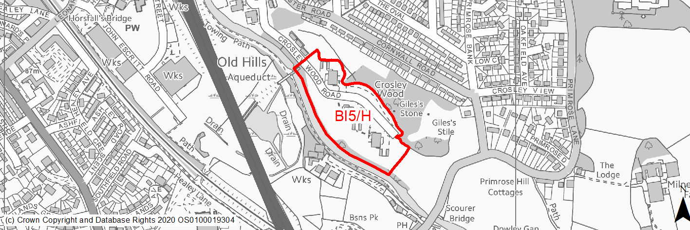
Site location
Principal Town - Bingley
Ward
Bingley
Site description
The site consists of areas of open space and car parking surrounding three multi-storey blocks of flats (Peel House, Brunswick House & Adelaide House). It also includes a number of wooded areas alongside the River Aire and to north of the site as well as a children's playground towards the eastern boundary.
Proposed Allocation
Housing
SHLAA referencce
BI/026
Indicative no. dwellings
93
Site area (Gross) (ha)
3.5
Ownership
Private
Delivery timescales
Deliverable (0-5 years), Developable (6-10 years)
Type (PDL/Greenfield)
Greenfield
Green Belt
Not applicable
Flood Zone
Flood Zone 3
Potential site access
Existing access to the site from Gloucester Road via Crosley Woods Road.
Public Transport Accessibility
Bus: Nearest bus stops located around 50m to the north of the site on Gloucester Road and Kent Road. These provide one service per hour in each direction to Eldwick and Bradford (via Bingley).
Rail: Bingley railway station is around 1km to the north west. This offers 4 services per hour towards Keighley & Skipton, 3 per hour to Leeds & 2 per hour to Bradford Forster Square, with additional limited services to Carlisle & Lancaster/Morecambe.
Sustainability Appraisal
Bingley South Bog SSSI is approximately 20m west of the site and so careful consideration for potential impacts on this sensitive biodiversity designation would be required in order to avoid a significant effect on the biodiversity SA Objective. Site potentially contains BMV land. No other significant adverse effects have been recorded for this site, with minor adverse effects predicted for most other natural environment themed SA Objectives primarily as a result of the potential loss of greenfield and impacts on woodland, as well as the adjacent water body. Being adjacent to the Leeds Liverpool Canal, careful consideration around protecting water quality would be required. The site is adjacent to the Leeds Liverpool Canal Conservation Area.
The site offers excellent access to health and education facilities. Development could potentially be an opportunity to positively enhance the site’s influence on the local character as a result of redeveloping the three blocks of flats here.
Habitats Regulations Assessment
This site falls within 7km of the South Pennine Moors SPA/SAC. A HRA must be undertaken to ensure there are no significant effects on these protected sites. Developments within these zones must comply with Policy SP11; a SPD is being produced to provide further guidance.
Green Belt
N/A – Site not within the Green Belt.
Constraints and Opportunities
• The site is located within the built up area of Bingley. It was previously occupied by three multi storey residential blocks that have since been demolished together with areas of car parking, open space and woodland.
• It is located close to the Leeds and Liverpool Canal Conservation Area and a Scheduled Monument as well as a SSSI.
• It is within the 7km buffer of the SPA/SAC.
• The site is currently the subject of a planning application for residential development (93 dwellings).
Development considerations
• Mitigation through design of impacts on setting of the Conservation Area.
• Ecological survey will required to assess the impact of development on the adjacent SSSI and priority habitats.
Conclusion/Summary
This is a sustainable site located in the built up area of Bingley, close to local facilities and services. The site will deliver 93 dwellings. Mitigation may be required to address its proximity of a conservation area and scheduled monument as well as a SSSI.
(6) BI6/H - Marley Court, Crossflatts
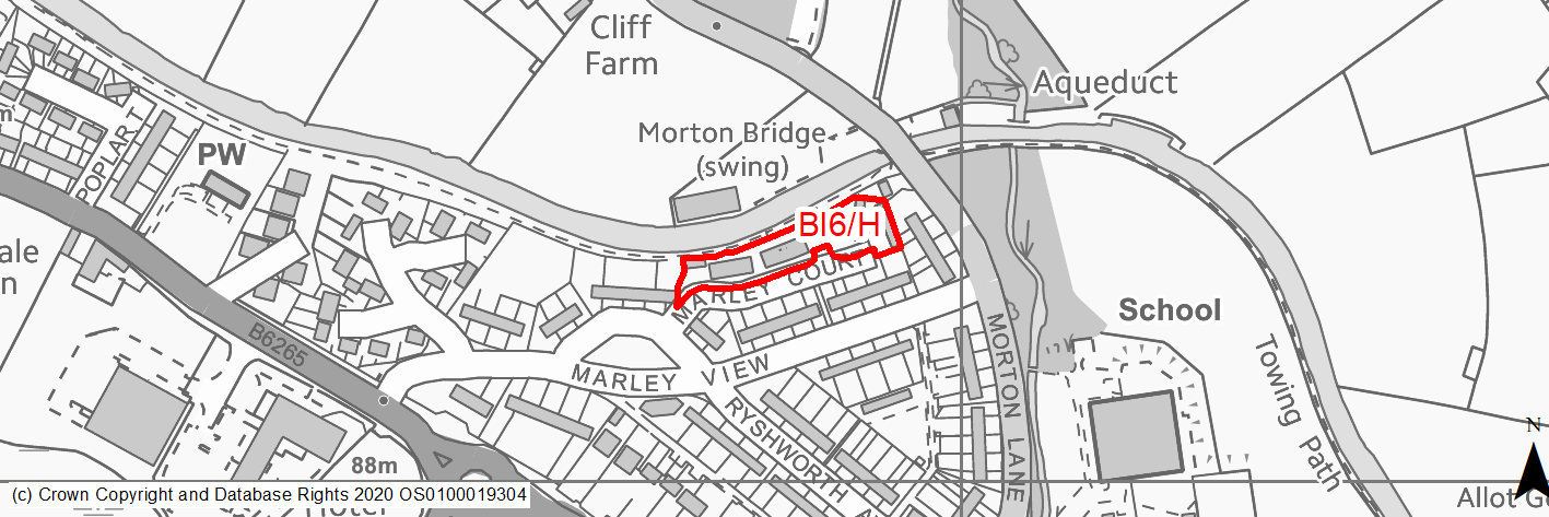
Site location
Principal Town - Bingley
Ward
Bingley
Site description
The site consists of an area of grassed land alongside the towpath of the Leeds & Liverpool Canal. It was previously occuped by flats.
Proposed Allocation
Housing
SHLAA referencce
BI/038
Indicative no. dwellings
19
Site area (Gross) (ha)
0.3
Ownership
Private
Delivery timescales
Deliverable (0-5 years)
Type (PDL/Greenfield)
PDL
Green Belt
Not applicable
Flood Zone
Flood Zone 4
Potential site access
Existing access present (Marley Court).
Public Transport Accessibility
Bus: Nearest bus stops located 140m and 170m to the south of the site on Keighley Road. The former offers 9 services per hour to Bradford (7 per hour) and Leeds (2 per hour), with the latter offering 7/8 services per hour to Keighley.
Rail: Crossflatts railway station is around 900m from the site.
Sustainability Appraisal
No major adverse effects have been predicted for the site. As a PDL site, there are opportunities here for achieving biodiversity net gains and improvements to the local character as well as the setting of nearby heritage assets. The site has excellent access to health facilities, and good access to all other services and amenities that would be needed by residents here. Being adjacent to the Leeds Liverpool Canal, careful consideration around protecting water quality would be required.
Habitats Regulations Assessment
This site falls within 2.5km of the South Pennine Moors SPA/SAC a HRA must be undertaken to ensure there are no significant effects on these protected sites in terms of impact on supporting habitat which might be functionally linked to the SPA and recreational pressures. Developments within these zones must comply with Policy SP11; an SPD is being produced to provide further guidance.
Green Belt
N/A – Site not within the Green Belt.
Constraints and Opportunities
• This is a previously developed site situated in the Crossflatts area of Bingley. It was occupied by several blocks of flats which have been demolished.
• It is adjacent to the Leeds & Liverpool Canal, which is designated as a Conservation Area as well as a Local Wildlife Site (LWS).
• Access is in place via Marley Court.
• It is within the 2.5km buffer of the SPA/SAC.
• The site is currently the subject of a planning application for residential development (19 dwellings).
Development considerations
• Mitigation through design of the impacts on the Conservation Area.
• Ecological survey will be required to assess potential impacts on adjacent LWS and habitat network.
• Contaminated land assessment will be required as the site is previously developed.
Conclusion/Summary
This is a sustainable, previously developed site with the existing built up area of Bingley (Crossflatts), close to local services and facilities including public transport and primary school. The site will deliver 19 dwellings. Mitigation may be required to address its proximity to a Conservation Area and Local Wildlife Site as well as any potential contamination from its previous use.
(4) BI7/H - Whitley Street
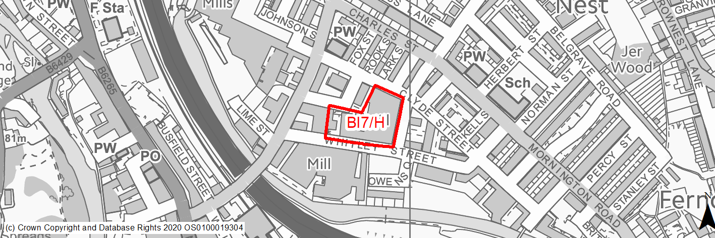
Site location
Principal Town - Bingley
Ward
Bingley
Site description
The site consists of several vacant and underused buildings located to the north side of Whitley Street and west side of Lund Street. A number of businesses currently operate from the site.
Proposed Allocation
Housing
SHLAA referencce
BI/040
Indicative no. dwellings
30
Site area (Gross) (ha)
0.5
Ownership
Private
Delivery timescales
Developable (6-10 years)
Type (PDL/Greenfield)
PDL
Green Belt
Not applicable
Flood Zone
Flood Zone 5
Potential site access
From Whitley Street, Lund Street & Clyde Street.
Public Transport Accessibility
Bus: Nearest bus stops located 70m & 75m to the north of the site on Charles Street. These offer 1 service per hour in each direction to Eldwick and Bradford (via Bingley). Other stops with more frequent services are located around 190m & 200m to the south west of the site. The former offers 13 services per hour to Bradford (7 per hour), Leeds (2 per hour), Eldwick (2 per hour), Cullingworth (1 per hour) & Keighley (1 per hour), whilst the latter offers 12 services per hour to Keighley (9 per hour), Bradford (2 per hour) & Cullingworth (1 per hour).
Rail: Bingley railway station is located 160m to the south of the site in a straight line/290m via quickest walking route. This offers 4 services per hour towards Keighley & Skipton, 3 per hour to Leeds & 2 per hour to Bradford Forster Square, with additional limited services to Carlisle & Lancaster/Morecambe.
Sustainability Appraisal
No major adverse effects have been predicted for the site. As a PDL site, there are opportunities here for achieving biodiversity net gains and improvements to the local character as well as the setting of nearby heritage assets. The site has excellent access to transport, health and education facilities, with good access to all other services and amenities that would be needed by residents here.
Habitats Regulations Assessment
This site falls within 7km of the South Pennine Moors SPA/SAC. A HRA must be undertaken to ensure there are no significant effects on these protected sites. Developments within these zones must comply with Policy SP11; a SPD is being produced to provide further guidance.
Green Belt
N/A – Site not within the Green Belt.
Constraints and Opportunities
• This site consists of an existing former mill building complex, that is currently occupied by a number of business, close to the centre of Bingley.
• It is within the Leeds & Liverpool Canal Conservation Area and within close proximity to a number of Listed Buildings.
• A gas pipeline runs adjacent to the eastern boundary.
• The site is within the 2.5km buffer of the SPA/SAC.
Development considerations
• Mitigation through design of the impacts on the Conservation Area and settings of adjacent listed buildings.
• Contaminatation assessment to determine and mitigate impacts of current uses.
Conclusion/Summary
This is sustainable site close to the centre of Bingley, that offers a potential opportunity for conversion and/or redevelopment subject to it becoming available over the plan period. It is close existing local services and facilities include public transport and shops.
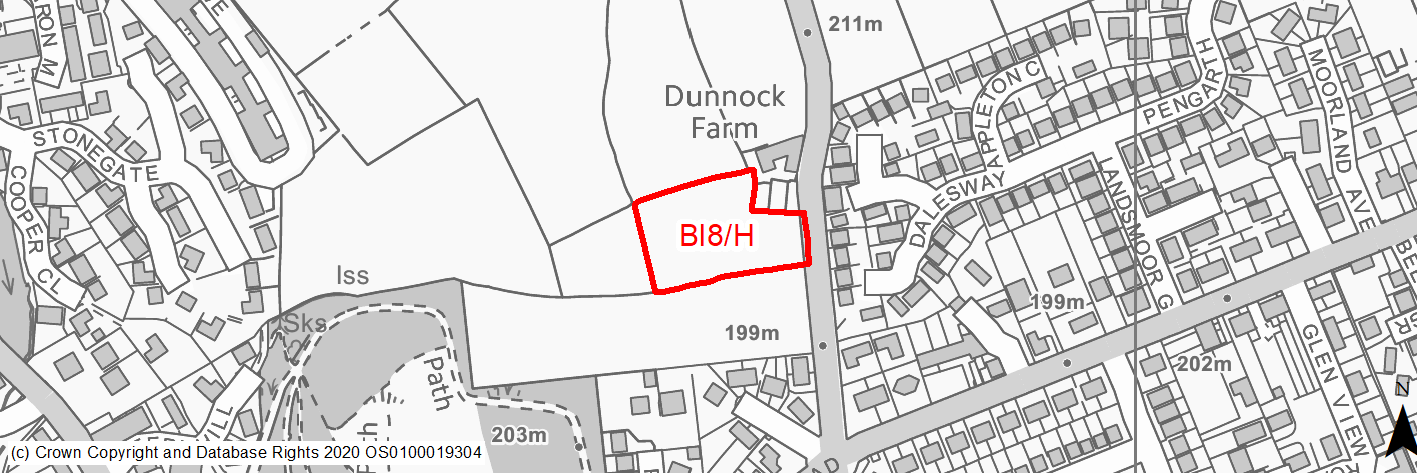
(178) BI8/H - Land west of Heights Lane, Eldwick
Site location
Principal Town - Bingley
Ward
Bingley
Site description
The site consists of several agricultural fields that surround the complex of buildings known as Dunnock Farm.
Proposed Allocation
Housing
SHLAA referencce
BI/059a
Indicative no. dwellings
18
Site area (Gross) (ha)
0.56
Ownership
Private
Delivery timescales
Developable (11-15 years)
Type (PDL/Greenfield)
Greenfield
Green Belt
Green Belt
Flood Zone
Flood Zone 6
Potential site access
Existing field access from Heights Lane at north east corner of the site.
Public Transport Accessibility
Bus: Nearest bus stops located around 130m to the south west of the site on Otley Road. These provide 2 services per hour in each direction to Eldwick and Bradford (via Bingley).
Rail: Bingley station is around 1.4km (straight line)/1.8km (via quickest walking route) to the south west of site.
Sustainability Appraisal
BI/059 is within 50m north/east of the Prince of Wales Registered Park. New development here could potentially adversely alter the setting of this highly sensitive heritage asset.
As a large greenfield and Green Belt site adjacent to a LWS and priority habitat, the development has been predicted to result in minor adverse effects on most natural environment themed SA Objectives.
The loss of the greenfield site is also likely to have a negative impact upon the local landscape and townscape, including the Prince of Wales Park (a Registered Park/Garden) which is 50m south the site.
The site offers excellent access to healthcare facilities.
Minor positive effects were also predicted for most socio-economic themed SA Objectives due to the benefits of new residential development for the local economy as well as the location of the site in relation to transport links, education facilities and employment areas.
Habitats Regulations Assessment
This site falls within 2.5km of the South Pennine Moors SPA/SAC a HRA must be undertaken to ensure there are no significant effects on these protected sites in terms of impact on supporting habitat which might be functionally linked to the SPA and recreational pressures. Developments within these zones must comply with Policy SP11; an SPD is being produced to provide further guidance.
Green Belt
Based on planning judgement the site has a major potential impact on the Green Belt.
• The site is located in a moderate performing Green Belt parcel.
• The site makes a major contribution to the purposes of including land in the Green Belt.
• The site has a major potential for sprawl and would have a major impact on the openness.
• The site does not present an opportunity to create a stronger boundary than that of the existing one.
Constraints and Opportunities
• This reserve site is currently designated as Green Belt, and the site specific Green Belt Assessment indicates that it has a major potential impact.
• It is close to a Local Wildlife Site and Listed Park (Prince of Wales Park), with the potential to impact on their settings.
• Also within the 2.5km buffer of the SPA/SAC.
• The proposed boundary represents the opportunity to ensure a sufficient buffer for the Listed Park.
Development considerations
• Bird survey due to proximity to SPA/SAC and need to consider foraging birds.
• Significant buffer zone will be required as part of design to reduce impacts on Listed Park and priority woodland habitats.
• Ecology survey required.
• Appropriately designed access from Heights Lane.
Conclusion/Summary
This site is sustainably located adjacent to the settlement boundary for Bingley and provides suitable, small scale extension to the built up area, subject to the consideration highlighed being addressed. The proposed boundary allows for sufficient buffer to be maintained with Prince of Wales Park. It will deliver an estimated 25 dwellings.