
Draft Bradford District Local Plan - Preferred Options (Regulation 18) February 2021
Steeton with Eastburn
Introduction
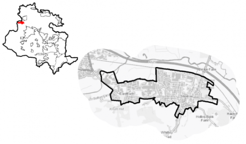
5.14.1 Steeton with Eastburn is situated in the north west of Bradford district, immediately adjacent to the local authority boundary with North Yorkshire (Craven District) on the southern edge of the valley of the River Aire, which flows through the valley bottom to the north and east of the village. It is approximately 5km miles north west of Keighley and 8 km south of Skipton. The River Aire creates a natural division between Steeton and Silsden, approximately 3km to the north. It falls within the Craven Ward together with the settlements of Addingham and Silsden and is part of the Keighley parliamentary consistency. Steeton with Eastburn Parish Council acts an administrative body for the parish area.
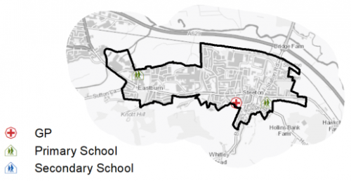
Figure 1: Location Map
5.14.2 The settlement has strong commuter connections to nearby towns and cities including Keighley, Leeds, Bradford and Skipton but also an established local employment base. There are a range of local services and facilities that support the needs of the community.
5.14.3 Steeton with Eastburn has a resident population of 4,770. The majority of the population (59.6%) is of working age, which is below the West Yorkshire average, however it also has a higher percentage of residents (20.9%) who are aged 65 and over, compared to the sub-regional level (16.7%). The population aged 15 and under is slightly lower than the sub-regional average. The largest majority (around 91.8%) of the population identify as being of White British ethnicity which is higher than the District, West Yorkshire and regional levels but not uncommon in relation to similar settlements.
5.14.4 In terms of household composition, the largest proportion consists of married and co-habiting households (51.3%), compared to a West Yorkshire level of 43.1%. 22.2% of households consist of those aged 65 and over, which is above the West Yorkshire level.
5.14.5 The Parish Council is working with the neighbouring Silsden Town Council to prepare of a Neighbourhood Plan that will help to shape how their communities will grow and develop in the coming years (up to 2030). It sets outs local priorities and policies that will be used, once adopted, as part of the statutory development plan to make decisions on planning applications in the town. The Neighbourhood Plan has recently been subject to an independent examination.
Planning for Prosperity
5.14.6 The Local Plan settlement hierarchy identifies Steeton with Eastburn as a Local Growth Centre. It is considered to be one of the most sustainable locations and is accessible to higher order settlements. As such it will help make a significant contribution of the meeting the District's housing needs, employment and providing supporting community facilities.
5.14.7 Craven ward, which includes Steeton with Eastburn, is positively ranked 28th of 30 wards in the District for the combined Index of Multiple Deprivation[1]. It is in 28th place for income and employment deprivation, and 27th place for education, skills and training deprivation. Economic activity rates are similarly positive and higher than the West Yorkshire and England averages - 73.4% of working age residents are classed as being economically active (compared to 68.5% sub-regional average), most of whom (43.6%) are in employment, mainly full time employment. The number of self-employed people (9.9%) is also above the West Yorkshire average (8.1%). The average annual household income is £40,700 which is higher than the West Yorkshire average of £38,499.
Economy and Employment
5.14.8 Steeton with Eastburn has strong commuter connections to nearby larger towns and cities. However, there are a number of active businesses in the area of various sizes offering employment opportunities. The largest employers in the village are Five Landis Ltd and Airedale Hospital. Fives Landis Ltd, manufacture and supply high precision grinding machinery for the automotive industry from their site in Eastburn. There are also two industrial estates – Eastburn Mills Industrial Estate and the Millennium Business Park/Steeton Grove. The former has a number of units that are occupied by a range of small businesses, whilst the latter is home to several smaller and larger businesses including Damart, Tellemachus, Specialist Ducting Supplies and Brooks Stairlifts as well as providing office space for the NHS and an HGV driving test centre. A smaller business/industrial area is situated adjacent to the railway station on the site of the former goods yard.
5.14.9 Business Register and Employment Survey (BRES) data indicates that the three largest industry groups by workforce jobs (all people in employment) are health (57.1%), manufacturing (19.1%) and business, administration and support services (10.5%). This potential reflects the presence of Airedale General Hospital.
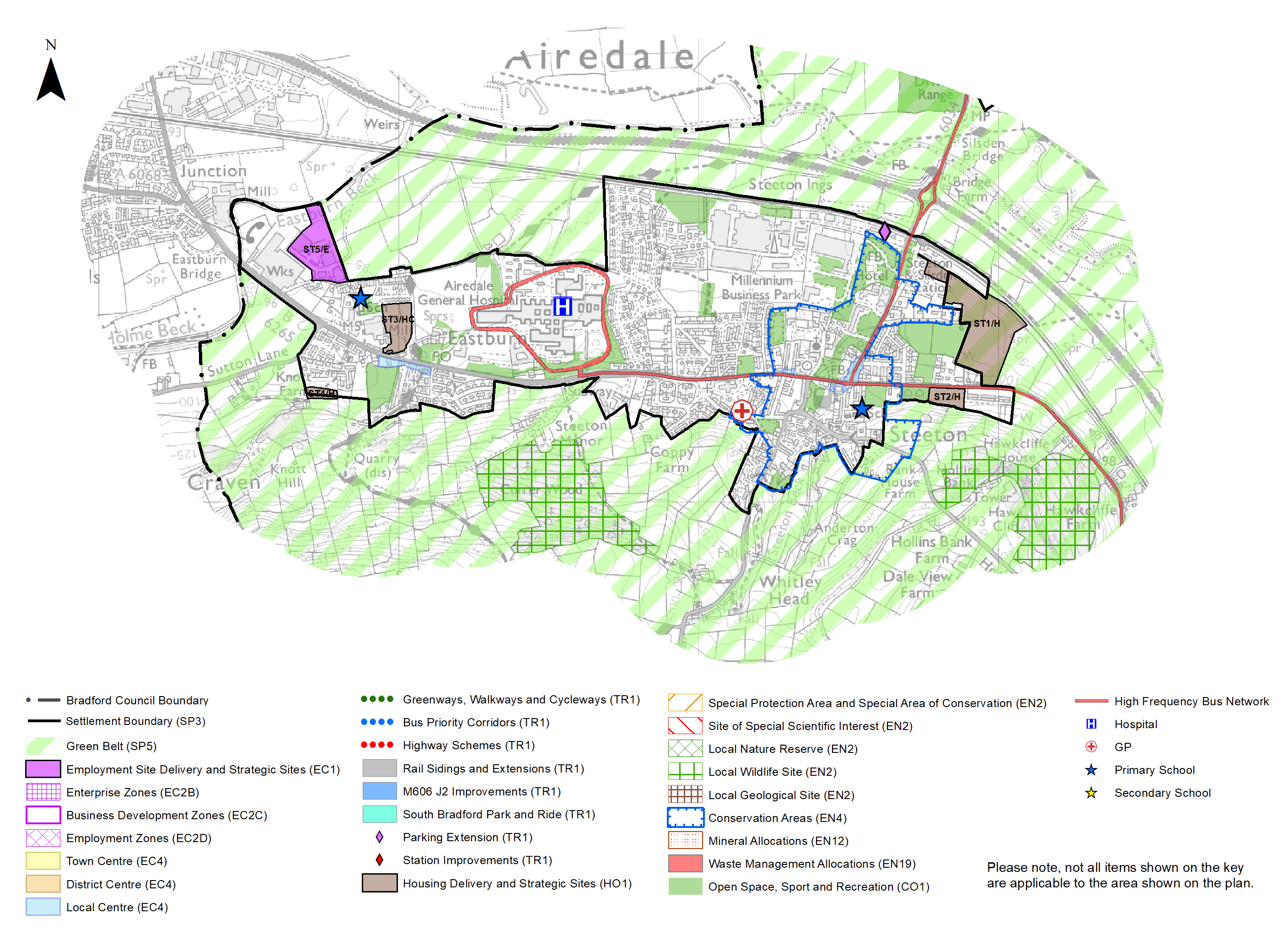
5.14.10 Policy SP6 sets a District employment land requirement of at least 72ha. Although no general employment or industrial sites have been identified in Steeton as suitable for allocation, land at Lyon Road (site ST5/E) has been identified as a potential employment site to support the expansion of an existing business.
5.14.11 In order to support the economic ambitions for the area, table A provides details of the preferred employment site allocation within Steeton with Eastburn. The preferred employment site allocation is also identified on the Policies Map and in the site pro formas together with the local strategy.
Retail
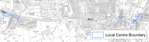
5.14.12 Steeton with Eastburn is designated in the retail hierarchy (Policy EC4) as a Local Centre. It is formed of two clusters of retail provision around 1.2km apart – one focussed around the junction of Main Road and Moor Lane in Eastburn and the other around the junction of Skipton Road/Keighley Road and Station Road in Steeton. The Eastburn cluster consists of a combined general/convenience store and post office, a takeaway and a public house, whilst the Steeton cluster includes butcher's, hair and beauty outlets, public house (The Goats Head), café and takeaway. A Co-op Food store is located on Skipton Road approximately midway between the two clusters and provides a significant contribution to the local convenience goods offer.
5.14.13 The 2019 Retail and Leisure Study highlighted that retail and service provision in the settlement is relatively limited. It recommended the Local Centre designation incorporating both clusters to ensure that the existing shops and services the settlement are protected to meet the day to day needs of the local community. The extent of the Local Centre boundary is shown on the Policies Map as well as Figure 2 (below).
Figure 2: Steeton with Eastburn Local Centres
Transport and Accessibility
5.14.14 Steeton with Eastburn is located within the key transport corridor running through the Aire Valley, providing good road and rail connections to nearby major towns and cities. It lies to the south of the A629, the main route through the Aire Valley between Bradford, North Yorkshire and East Lancashire. This gives access to other towns within Airedale including Keighley as well as to Bradford and Skipton. The village also straddles the B6265 (the former main route between Keighley and Skipton). The village is connected to the main A629 via Station Road, which then becomes the A6034 linking it to Silsden and the A65 at Addingham in the Wharfedale area.
5.14.15 Public transport links to and from Steeton with Eastburn are good. Steeton and Silsden station is located on the northern edge of the village and is a stop on the electrified Airedale line. This provides frequent links to Keighley, Bingley, Shipley, Bradford, Skipton and Leeds. Parking at the railway is a key issue. The village is also on high frequency bus routes providing connections to Keighley, Skipton, Burnley, Silsden, Addingham and Ilkley. One service per hour on the Ilkley route extends to serve Burley in Wharfedale, Menston, Otley and Leeds Bradford Airport.
5.14.16 Census data indicates that 84% of the population have access to a car or van is significantly higher than the district, sub-regional and regional levels. The largest proportion have access to one vehicle. Steeton with Eastburn is not covered by an Air Quality Management Area (AQMA) and lies outside the proposed Clean Air Zone (CAZ).
5.14.17 In relation to digital connectivity, average broadband download speeds in Steeton with Eastburn is just under 36 megabytes per second – below the West Yorkshire average (44.57 Mbit/s), whilst there are 9 premises where speeds are below the Universal Service Obligation (USO)[2].
5.14.18 Strategic transport infrastructure projects to be delivered within the plan period and protected routes are set out on the Policies Map with key initiatives within Steeton with Eastburn, detailed in Table 1 below.
Table 1: Steeton with Eastburn Transport Projects
|
Policies Map Ref. |
Project Name |
|
TR1.B.2 |
Steeton and Silsden railway station Parking extension |
Planning for Homes
5.14.19 Steeton with Eastburn has 1,811 dwellings - the majority of which 79% are owner occupied which is above the West Yorkshire average of 63.4%. The largest proportion of the settlement's housing stock consists of terraced (39.7%) and semi-detached (38%) dwellings. This is above the West Yorkshire levels. The number of detached dwellings and flats are lower than the sub-regional averages. Further information is detailed in Figure 3.
Figure 3: Steeton with Eastburn – Housing Types
|
Detached |
Semi-detached |
Terraced |
Purpose built flat |
|||
|
244 |
689 |
719 |
122 |
|||
|
13.5% (West Yorkshire average = 16.4%) |
38.0% (West Yorkshire average = 36.0%) |
39.7% (West Yorkshire average = 30.7%) |
6.7% (West Yorkshire average = 13.7%) |
|||
|
Flat (in converted house) |
Flat (in commercial property) |
Caravan or other temporary dwelling |
Second homes (2001) |
|||
|
31 |
06 |
00 |
03 |
|||
|
1.7% (West Yorkshire average = 2.2%) |
0.3% (West Yorkshire average = 0.8%) |
0.0% (West Yorkshire average = 0.2%) |
0.2% (West Yorkshire average = 0.2%) |
|||
|
Source: Census 2011 |
||||||
5.14.20 The average house price for Steeton with Eastburn at £189.286 is slightly higher than the West Yorkshire average of £183,194. Detached dwellings and flats are generally cheaper, however the prices of semi-detached and terraced dwellings are higher overall. All dwelling types are generally lower in price than the national (England) average. The total affordability ratio between house prices and annual earnings which is usually used as a proxy for number of years' worth of earnings required for a house deposit is 3.81 compared to a West Yorkshire average of 2.96.
5.14.21 Delivering new housing is a key part of the overall development strategy for Steeton with Eastburn. It will ensure that the housing needs and aspirations of local people can be met, together with those of future residents, including the provision market and affordable housing. In addition, it will support the economy and reflect its role as a Local Growth Centre.
5.14.22 Policy SP8 in the Local Plan sets out a minimum requirement of 175 dwellings to be delivered in Steeton with Eastburn during the plan period. These will be delivered through a mix of committed sites (those under construction or have planning permission but have not yet commenced) and new allocations. Table 2 below sets out the housing position for Steeton with Eastburn, which also includes the application of non- implementation or discount rates for planning permissions and allocations. The Council will be supportive of additional proposals for new homes on additional small sites, particularly those that provide a redevelopment opportunity to bring forward land which has been previously used. Support will also be provided to developers who wish to redevelop larger sites and/or buildings for new homes not currently identified, subject to all relevant policies in the Local Plan
Table 2: Steeton with Eastburn - Summary of Housing Requirement and Supply
|
Housing Target |
175 units |
|
Carried Forward Commitments |
13 |
|
Commitment Discounted by 10% |
12 |
|
Remaining Allocation Requirement |
163 |
|
Identified Allocations |
188 |
|
Allocations Discounted by 10% |
169 |
|
Total Supply Contribution from Allocations |
169 |
5.14.23 Once the commitments are discounted and removed from the supply this leaves a residual allocation requirement of 163 units. The evaluated total site supply of housing units from preferred allocation sites equates to 188 units which is in turn discounted by 10% for non-implementation leaving a final allocation contribution of 169 units across all sites, which is very slightly above the allocation requirement but is reflective of site yield and the practicalities of redefining strong settlement boundaries.
5.14.24 Steeton with Eastburn is reasonably constrained for allocations within the established settlement boundary and the local plan proposes to allocate three greenfield sites, including one Green Belt site to meet the housing requirement for this area. In delivering the target for new homes in Steeton with Eastburn it has been necessary to make some changes to the adopted green belt. Policy SP5 sets out The Councils approach and justification for green belt releases to accommodate new development and lists the sites proposed for allocation which current lie within or partly within the green belt.
5.14.25 The new local plan preferred site allocations for residential and mixed allocations to meet Steeton with Eastburn's housing requirement are set out in Table B and identified on the Policies Map and the Site Pro Formas below together with the local strategies map for each plan area. Development of site allocations should be in accordance with specified development guidelines and approximate site provision figures and all other relevant policies of this Local Plan.
Planning for Places and Communities
Green Belt, Natural Landscape and Historic Character
5.14.26 Steeton with Eastburn is surrounded by Green Belt to the north, south and east. This land falls within the Airedale Landscape Character Area. The prevailing landscape character is floodplain pasture to the north and east, and wooded incline to the south. The former is assessed as having a strong character, high historic continuity, and being prominent and open, whilst the latter is assessed as having a moderate character, high historic continuity and being prominent and open. The Landscape Character Assessment notes that both areas are considered to be sensitive to change.
5.14.27 There is one designated Conservation Area within Steeton with Eastburn. This covers the historic core of Steeton which is centred on Skipton Road, Keighley Road and Station Road to the north and Barrows Lane to the south. There are a total of 21 Listed Buildings within the settlement, all of which are Grade II Listed.
Green Infrastructure (GI), Ecology, Open Space and Flood Risk
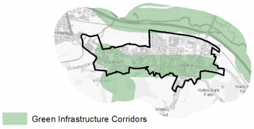
5.14.28 The village has a range of corridors and spaces that contribute towards its Green and Blue Infrastructure network. Key corridors include the valley of the River Aire (a regionally important GI corridor), Steeton Beck that flows from south to north through the centre of Steeton and Eastburn Beck that flows along the north western edge of Eastburn. Steeton Beck provides a wooded corridor through the village. The wooded incline to the south of the village has also been identified as being key element of the GI network. Figure 4 below provides an overview of the key Green Infrastructure corridors.
Figure 4: Green Infrastructure Corridors
5.14.29 Steeton with Eastburn has two biodiversity designations within and adjacent to the village in the form of Local Wildlife Sites (LWS). The Currer Woods LWS is located to the south, whilst the Hawkcliffe Woods LWS to the south east. A further LWS – the Steeton Reservoir LWS – is situated around 1.2km to the south of the village boundary. The South Pennine Moors Phase 2 SPA and SAC (and SSSI) is located around 3.1km and 3.5km to the south west and north east respectively, placing the settlement with the 7km buffer of the SPA/SAC.
5.14.30 The settlement in addition has 35 open spaces, totalling around 81ha of land. Key sites within the village include Eastburn Recreation Ground and Steeton Football and Cricket club grounds. The settlement has a reasonably good distribution of spaces throughout the settlement but there are notable deficiencies in certain types of open space, meaning high priority for increased provision of Parks and Gardens and Outdoor Sports sites including play provision for younger children. Figure 5 shows the location and type of open space in the settlement.
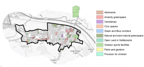 Figure 5: Steeton with Eastburn - Open Space Overview
5.14.31 Large areas of land to the north of Steeton with Eastburn and to the south of Silsden lie within a flood risk zone thus acting as constraints to any potential development in this area.
Community Infrastructure – Education, Health and Utilities
5.14.32 The village has a number of community facilities that contribute to the day to day needs of local people. These include a community hall (The Hub), post offices and public houses as well as three places of worship.
5.14.33 Steeton with Eastburn is served by 2 primary schools – Eastburn Junior & Infant School and Steeton Primary School. These schools have capacity for 525 pupils. Silsden Primary School is located in nearby in the neighbouring town and has capacity for 630 and a new primary school is being constructed in Silsden to replace the existing two sites. It is expected to open in 2021.
5.14.34 Steeton with Eastburn does not have a secondary school. The nearest schools within are in Keighley – The Holy Family Catholic School, Oakbank School and University Academy Keighley. A number of children also travel across the local authority boundary into North Yorkshire to access South Craven School in the neighbouring settlement of Cross Hills. All secondary schools include 6th Form provision. These schools have capacity for 5,223 pupils. All three Keighley schools are currently under subscribed, whilst South Craven is oversubscribed.
5.14.35 In addition to the 6th Form provision at the local secondary schools, local people have the opportunity to access post 16 education at several nearby Further Education colleges – Craven College in Skipton and Keighley College. Bradford College and Shipley College as well as the universities in Bradford and Leeds are also within reach.
5.14.36 Pupils attainment levels at Key Stage 4 (GCSE) are above the District, West Yorkshire and national (England) average scores – 398.5 compared to 335, 353.5 and 366.3 respectively. In relation to qualifications, Steeton with Eastburn has a higher proportion of working age residents with a Level 4 and above qualification[3] than the district, sub-regional and England averages.
5.14.37 Primary healthcare services are provided at Steeton Surgery. This is part of the Silsden & Steeton Medical Practice, which has 8 GPs and caters for 11,632 registered patients. Several of the GP surgeries/health centres in Keighley also include Steeton with Eastburn within their practice areas. The medical practice also includes a pharmacy.
5.14.38 Eastburn is also the location of Airedale General Hospital, one of Bradford district's two acute hospitals. It opened in 1970 and has 324 inpatient beds. It provides a wide range of services including Accident & Emergency and Maternity to a population of over 200,000 people in a large area of 700 square miles within Yorkshire and Lancashire. The area served includes area of North Bradford and Guiseley in West Yorkshire and extends into Colne and Pendle in East Lancashire. It is also major employer within the area, employing over 2,300 staff. Figure 6 shows the location of local services.
5.14.39 Airedale NHS Foundation Trust is keen to progress with a major project to build a new hospital on the site of the current Airedale General Hospital to address long standing structural problems with the current building and provide a range of new hospital facilities and complementary services.
5.14.40 ONS data indicates that the average life expectancy at birth for Steeton with Eastburn residents is 78 for men and 83 for women, which is similar to the West Yorkshire and England average. Healthy life expectancy is 65 for men and 67 women.
Figure 6: Schools & Medical Facilities in Steeton with Eastburn
5.14.41 Steeton with Eastburn is served by the Marley Waste Water Treatment Works, owned and operated by Yorkshire Water. Waste water is moved via the Aire Valley Trunk Sewer.
5.14.42 When planning for the long-term development of Steeton with Eastburn, it is vital that new development is supported by the appropriate infrastructure. The capacity, quality and accessibility of services and facilities are all key components in ensuring people can enjoy living, working and visiting the area. The council will continue work with key infrastructure providers and others including the Local Education Authority, Clinical Commissioning Group and utilities providers to determine the impacts of future growth and development on local infrastructure capacity and provision. Further infrastructure details will be published through the Local Infrastructure Plan and as part of the Regulation 19 stage of the local plan.
|
Local Area Strategy and Plan – Steeton with Eastburn |
|
The key elements of the local area strategy for Steeton with Eastburn include:
|
(13) Consultation Question 114
Steeton with Eastburn Local Area Strategy
The Local Plan sets out a local area strategy for Steeton with Eastburn.
Q. Please provide any comments you may have on the area strategy?
If you have an alternative to the approaches undertaken, please provide further details and evidence in support.
Preferred Site Allocations and Site Pro Formas
5.14.43 The preferred site allocations for Steeton with Eastburn for both employment and housing are detailed below in Tables A and B. These tables are subsequently followed by site pro formas for each preferred site allocation proving a summary of key site information and characteristics.
Table A: Steeton with Eastburn Employment Site - Preferred Allocations
|
Site Ref |
Site Name |
Type |
Site Area (Gross Hectares) |
|
ST5/E |
Lyon Road |
Brownfield / Greenfield split – Business Related |
2.69 |
|
Total |
2.69 |
Site ST5/E is not counted as contributing towards meeting general employment needs as is linked to the expansion of an existing business
Table B: Steeton with Eastburn Housing Site - Preferred Allocations
|
Site Ref |
Site Name |
Dwellings |
|
ST1/H |
Summerhill Lane |
120 |
|
ST2/H |
Aireburn Avenue |
22 |
|
ST3/HC |
West of Green Lane |
35 |
|
ST4/H |
Rear of Holly Fold |
11 |
|
Total |
188 |
Note: Site ST/3HC has outline planning permission.
(7) Consultation Question 115
Steeton with Eastburn Site Allocations and Site Pro Formas
The Local Plan sets out a series of preferred site allocations. If you wish to make representations on any of the sites proposed, please provide site reference and feedback under this question.
If you wish to propose an additional or alternative site(s) to the preferred allocations listed, please also provide a plan with a red line and any further details in support.
[1] Where 1 is the most deprived and 30 is the least deprived.
[2] Universal Service Obligation (USO) - download speeds at or above 10Mbit/s and upload speeds at or above 1Mbit/s including non-matched records and zero predicted speeds
[3] Level 1' qualifications are equivalent to a single O-level, GCSE or NVQ. 'Level 2' qualifications are equivalent to five O-levels or GCSEs. 'Level 3' qualifications are equivalent to two A levels. 'Level 4' qualifications are equivalent to degree level or higher.
(4) ST5/E - Lyon Road
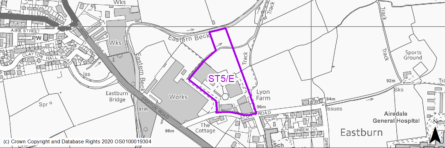
Site location
Local Growth Centre - Steeton with Eastburn
Ward
Craven
Site description
Agricultural land and buildings adjacent to industrial works.
Proposed Allocation
Employment
SHLAA referencce
ST/008
Indicative no. dwellings
N/A
Site area (Gross) (ha)
2.69
Ownership
Private
Delivery timescales
2030-38
Type (PDL/Greenfield)
PDL - 50% Greenfield - 50%
Green Belt
No
Flood Zone
Flood Zone 2.
Potential site access
Existing access off Lyon Road, but would need to be improved as quite narrow. Best suited as an expansion to the industrial premises to the west.
Public Transport Accessibility
Bus Stop outside 400m frequent service. Outside 800m of Rail Station
Sustainability Appraisal
The site has been proposed for employment development, which would be likely to deliver a major boost to the range of local employment opportunities at this location whilst also providing a boost to the local economy. A major positive score has therefore been predicted for the employment and economy themed SA Objectives.
Major adverse effects have been predicted for the site’s impact on the water resources SA Objective due to the presence of Eastern Beck within the site boundary. The construction and occupation of this site would be likely to impact the water quality.
Minor positive effects were predicted for other socio-economic themed SA Objectives due to the additional benefits of a new employment site, such as the potential for increasing the local offering of services and amenities and opportunities to learn new skills.
As a partial greenfield site including an area of trees, development here has been predicted to result in minor adverse effects on most natural environment themed SA Objectives. The site is partially PDL and contains existing buildings that appear to be of agricultural use, and there may therefore be somewhat limited scope for new development at this location to alter the local townscape and landscape character
Habitats Regulations Assessment
This site falls within 7km of the South Pennine Moors SPA/SAC a HRA must be undertaken to ensure there are no significant effects on these protected sites. Developments within these zones must comply with Policy SP11; an SPD is being produced to provide further guidance.
Green Belt
N/A – Site not within the Green Belt.
Constraints and Opportunities
• Narrow site assess off Lyon Road and would be best treated as expansion land to the industrial premises to the west.
• Site immediately abuts Green Belt.
• Hedgerows in the middle section of the site and along northern boundary.
• Potential impact on residential properties to the south.
• Flood Risk Level 2 with parcels of surface water risk.
Development considerations
• Expansion option for nearby industrial premises.
• Flood management within scheme detail.
• Environmental buffer to residential properties to the south.
Conclusion/Summary
Small employment land expansion option for neighbouring industrial premises.
Use Class
Class B2/B8
(33) ST1/H - Summerhill Lane
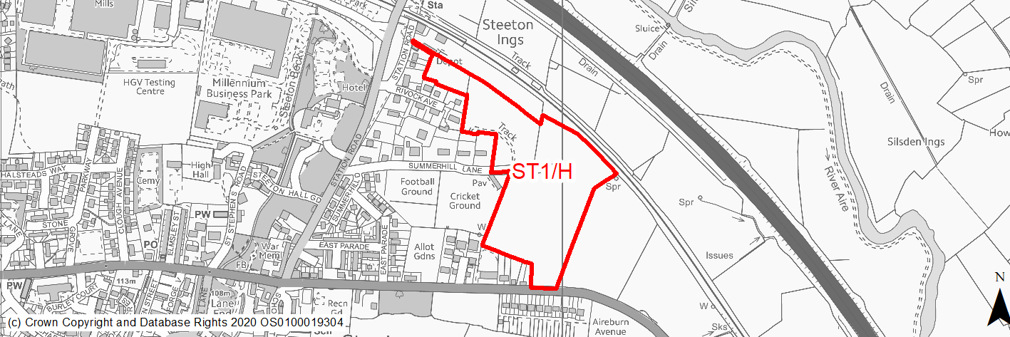
Site location
Local Growth Centre - Steeton with Eastburn
Ward
Craven
Site description
The site consists of three agricultural fields divided by stone walls on the eastern edge of Steeton with Eastburn. It is currently used for grazing.
Proposed Allocation
Housing
SHLAA referencce
ST/001a
Indicative no. dwellings
120
Site area (Gross) (ha)
5.34
Ownership
Private
Delivery timescales
Developable (6-15 years)
Type (PDL/Greenfield)
Greenfield
Green Belt
Yes
Flood Zone
Flood Zone 1 (76%), Flood Zone 2 (5%), Flood Zone 3b (19%)
Potential site access
Existing field access available close to bus stop on B6265 Keighley Road.
Public Transport Accessibility
Bus: The nearest bus stops are located immediately to the south on Keighley Road and around 80m & 170m to the west on Station Road. The first pair provide 6 services per hour to Keighley Bus Station (eastbound) and Burnley (2 per hour), Leeds Bradford Airport (1 per hour), Ilkley (1 per hour) & Skipton (2 per hour). A more limited/infrequent service also runs between Keighley & Silsden. Services 62, 66, 903 & M4. The second pair provide 2 services per hour to Ilkley (1 per hour) and Leeds Bradford Airport (1 per hour) (northbound) and Keighley (2 per hour) (southbound). A more limited/infrequent also runs between Keighley & Silsden. Services 62 & 903.
Rail: North western boundary of the site is adjacent to Steeton & Silsden railway station. This offers 8 services per hour to Leeds (2 per hour), Bradford Forster Square (2 per hour) & Skipton (4 per hour).
Sustainability Appraisal
The site could deliver a major positive effect for residents on the transport SA Objective as a result of being within the target distances for bus stops and a railway station.
Minor positive effects were predicted for most socio-economic themed SA Objectives due to the benefits of new residential development for the local economy as well as the location of the site in relation to health facilities, local services and amenities, and education facilities.
No significant adverse effects have been predicted, but as a large greenfield site, development here would likely result in minor adverse effects on all the natural environment themed SA Objectives. The site is 30m east of the Steeton Conservation Area, the setting of which could be adversely affected as a result of new development.
Habitats Regulations Assessment
This site falls within 7km of the South Pennine Moors SPA/SAC. A HRA must be undertaken to ensure there are no significant effects on these protected sites. Developments within these zones must comply with Policy SP11; a SPD is being produced to provide further guidance.
Green Belt
Based on planning judgement the site has a major potential impact on the Green Belt.
• The site is in a major Green Belt parcel.
• The site makes a major contribution to the purposes of including land in the Green Belt.
• The site has a major potential for sprawl and would have a major impact on openness.
• There are limited opportunities to create a stronger Green Belt boundary than the existing boundary.
Constraints and Opportunities
• This is a partly sloping, open site, the majority of with is located in the Green Belt on the edge of Steeton.
• The site specific Green Belt assessment indicates that it has a major potential impact.
• There is potential landscape and visual impacts due to its location and impact on the setting of the Conservation Area will need to be considered.
• Flood risk and drainage is also a potential issue.
• It is close to the Steeton and Silsden railway station, and offer the opportunity to create a pedestrian and cycle link to it.
• An apporpriate access is required.
Development considerations
• Sensitive design and layout is required to address and reduce landscape and visual impacts. Appropriate provision of tree belts around the boundary to screen views from the neighbouring road network and longer distance views from the surrounding countryside.
• Should include a robust green infrastructure network to integrate views with the surrounding countryside.
• Flood risk assessment will be required.
• Investigate and mitigate impacts on the setting of the Conservation Area.
• Investigate and mitigate surface water flooding and drainage issues.
• Investigate the provision of an appropriate vehicular access from Keighley Road.
Conclusion/Summary
This is a sustainable site located adjacent to the settlement boundary and close to nearby services and facilities including a railway station, with a frequent service. The site would deliver an estimated 120 dwellings but will need a sensitive design to mitigate the significant landscape and visual impacts.
(11) ST2/H - Aireburn Avenue
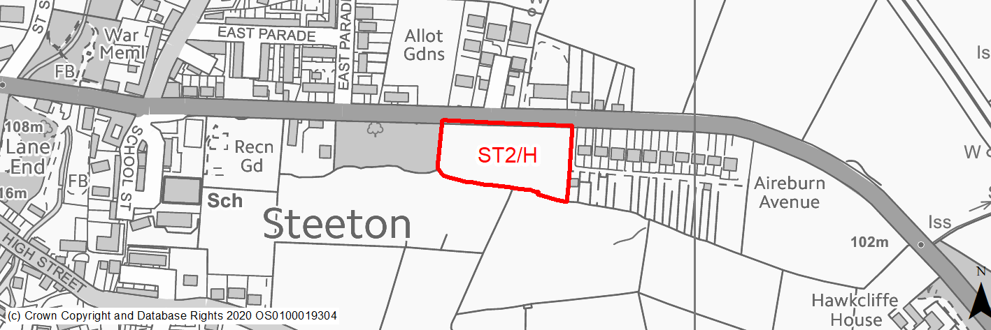
Site location
Local Growth Centre - Steeton with Eastburn
Ward
Craven
Site description
The site consists of a sloping agricultural field on the south eastern edge of the Steeton with Eastburn within the settlement boundary. It is currently used for grazing and haymaking.
Proposed Allocation
Housing
SHLAA referencce
ST/002
Indicative no. dwellings
22
Site area (Gross) (ha)
0.7
Ownership
Private
Delivery timescales
Developable (6-10 years)
Type (PDL/Greenfield)
Greenfield
Green Belt
No
Flood Zone
Flood Zone 1
Potential site access
Existing field access available at north east corner of site from B6265 Keighley Road.
Public Transport Accessibility
Bus: The nearest bus stops are located around 60m and 90m to the east of the site on Keighley Road. These provide 6 services per hour to Keighley Bus Station (eastbound) and Burnley (2 per hour), Skipton (2 per hour), Ilkley (1 per hour) & Leeds Bradford Airport (1 per hour) (westbound). Services 62, 66 & M4.
Rail: Steeton & Silsden railway station is located around 490m (in a straight line)/950m (via quickest walking route) (circa 12 mins) to the north of the site. his offers 8 services per hour to Leeds (2 per hour), Bradford Forster Square (2 per hour) & Skipton (4 per hour).
Sustainability Appraisal
No significant adverse effects predicted at the site. The site is on greenfield and minor adverse effects have been predicted for most natural environment themed SA Objectives. Site is well located to provide residents with access to jobs, cultural and recreational spaces, and schools with a particularly good access to health facilities. Access to other services and amenities, such as shops, is somewhat limited at this location.
Habitats Regulations Assessment
This site falls within 7km of the South Pennine Moors SPA/SAC. A HRA must be undertaken to ensure there are no significant effects on these protected sites. Developments within these zones must comply with Policy SP11; a SPD is being produced to provide further guidance.
Green Belt
N/A – Site not within the Green Belt.
Constraints and Opportunities
• This is a sloping, greenfield site within the settlement boundary for Steeton.
• It is within close proximity to the village centre and local facilities.
• There are potential drainage issues, whilst the setting of the Conservation Area will need to be considered.
• Within the 7km buffer of the SPA/SAC.
Development considerations
• Consider and mitigate any impacts on the setting of the Conservation Area through design and layout.
• Access available from Keighley Road.
• Investigate and mitigate drainage issues.
• Consider and address topography.
Conclusion/Summary
This is sustainable site within the settlement boundary of Steeton, close to local services and facilities including a primary school, recreation ground and public house. It is also on a public transport corridor. It will deliver an estimated 22 dwellings, but require an appropriate layout and design to address topography and proximity to Conservation Area.
(8) ST3/HC - West of Green Lane
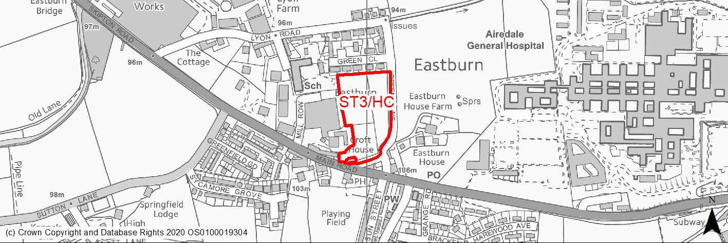
Site location
Local Growth Centre - Steeton with Eastburn
Ward
Craven
Site description
This is a greenfield site located in Eastburn, on the northern side of Main road, beyond North View and adjacent to Green Lane. The site slopes gradually down to residential properties on the northern boundary, Green Close. Eastburn Primary School and a number of industrial buildings are situated to the north western and western boundaries respectively.
Proposed Allocation
Housing
SHLAA referencce
ST/010B
Indicative no. dwellings
35
Site area (Gross) (ha)
1.33
Ownership
Private
Delivery timescales
Deliverable (0-5 years)
Type (PDL/Greenfield)
Greenfield
Green Belt
No
Flood Zone
Flood Zone 1
Potential site access
Access to be taken off Main Road (B6265).
Public Transport Accessibility
Public transport accessibility has been taken into account as part of the planning application process.
Sustainability Appraisal
Development at this site would be unlikely to result in a significant effect, either positive or negative, on any SA Objective.
Minor positive effects were predicted for a range of socio-economic themed SA Objectives due to the benefits of new residential development for the local economy as well as the location of the site in relation to transport links, education facilities and employment areas. However, residents may need to travel outside the target distance to access basic services and amenities.
No major adverse effects have been predicted for the site, but minor adverse effects were predicted for a range of natural environment themed SA Objectives, primarily as a result of the impacts of new development on a 100% greenfield site containing TPO woodland and trees.
Habitats Regulations Assessment
This site falls within 7km of the South Pennine Moors SPA/SAC a HRA must be undertaken to ensure there are no significant effects on these protected sites in terms of recreational pressures. Developments within these zones must comply with Policy SP11; an SPD is being produced to provide further guidance.
Green Belt
N/A – Site not within the Green Belt.
Constraints and Opportunities
• Relevant constraints and opportunities have been considered as part of the planning application process.
Development considerations
• Relevant development considerations have been taken into account as part of the planning application process.
Conclusion/Summary
This site has outline planning permission for 35 dwellings (19/01509/MAO approved of 06.11.19).
(8) ST4/H - Rear of Holly Fold
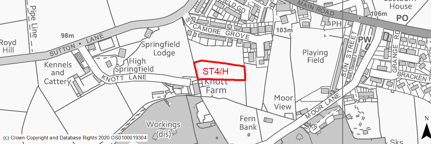
Site location
Local Growth Centre - Steeton with Eastburn
Ward
Craven
Site description
The site consists of grazing land enclosed by dry stone walls to the east and west.
Proposed Allocation
Housing
SHLAA referencce
ST/023
Indicative no. dwellings
11
Site area (Gross) (ha)
0.35
Ownership
Private
Delivery timescales
Deliverable (0-5 years)
Type (PDL/Greenfield)
Greenfield
Green Belt
Green Belt (31%)
Flood Zone
Flood Zone 1
Potential site access
Access via Holly Fold from Acre Close and Syamore Way.
Public Transport Accessibility
Bus: The nearest bus stops are located around 170m and 190m to the north on Skipton Road. These provide 4 services per hour to Keighley (eastbound) and Burnley (2 per hour) & Skipton (2 per hour) (westbound). Services 66 & M4.
Rail: Steeton & Silsden railway station is located around 2.1km (in a straight line)/2.6km (via quickest walking route - circa 30 mins). This offers 8 services per hour to Leeds (2 per hour), Bradford Forster Square (2 per hour) & Skipton (4 per hour).
Sustainability Appraisal
Development at this site would be unlikely to result in a significant effect, either positive or negative, on any SA Objective.
Minor positive effects were predicted for a range of socio-economic themed SA Objectives due to the benefits of new residential development for the local economy as well as the location of the site in relation to health facilities, transport links, education facilities and employment areas. However, residents may need to travel outside the target distance to access basic services and amenities.
No major adverse effects have been predicted for the site, but minor adverse effects were predicted for a range of natural environment themed SA Objectives, primarily as a result of the impacts of new development on a 100% greenfield site in proximity to two areas of deciduous woodland priority habitat.
Habitats Regulations Assessment
This site falls within 7km of the South Pennine Moors SPA/SAC. A HRA must be undertaken to ensure there are no significant effects on these protected sites. Developments within these zones must comply with Policy SP11; a SPD is being produced to provide further guidance.
Green Belt
N/A – Site not within the Green Belt.
Constraints and Opportunities
• This is a sloping site that is within the settlement boundary for Eastburn.
• It is located close to public transport services as well as local facilities include a shop and primary school.
• It is steeply sloping
• It is crossed by an overhead powerline.
• It is crossed by a public right of way (Footpath) providing a pedestrian link to Acer Close and Main Road.
• Within the 7km buffer of the SPA/SAC
• It is the subject of a planning application residential development.
Development considerations
• Consider and mitigate the topography of the site through sensitive design and layout as well as the provision of appropriate landscaping.
• Consider and address the presence of the Public Right of Way (Footpath).
• Access available from Acer Close via Holly Fold.
• Consider and address the presence of the powerline.
Conclusion/Summary
This is sustainable site within the settlement boundary of Steeton with Eastburn, close to local services and facilities including a primary school, recreation ground and public house. It is close to a public transport corridor. It will deliver an estimated 11 dwellings, but require an appropriate layout and design to address topography.