
Draft Bradford District Local Plan - Preferred Options (Regulation 18) February 2021
Denholme
Introduction
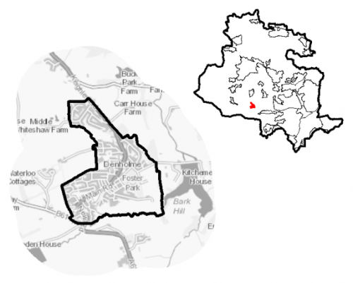
5.20.1 Denholme is a small village which is located 9km to the west of Bradford city on the A629, the main transport route connecting Halifax and Keighley. The settlement sits on a hillside within the wider South Pennine moors and is a relatively isolated residential community, now primarily a commuter settlement. The village is one of nine settlements located in the South Pennine Towns and Villages sub-area. Denholme falls within the Shipley Parliamentary Constituency and within the Bingley Rural Ward.
Figure 1: Location Plan
5.20.2 The settlement has a total population of 2,825 and a high percentage of this (62.3%) falls within the working age category (16-64). The age profile of the settlement is comparable to the West Yorkshire average with a slightly higher percentage of over 65s (17.9% compared to the sub-regional average of 16.7%). The ethnic composition of Denholme is primarily made up of people who identify themselves as White British - accounting for 93.4%. This is a notably higher proportion than the West Yorkshire average (78.4%), but is similar to other smaller rural settlements in the District.
Planning for Prosperity
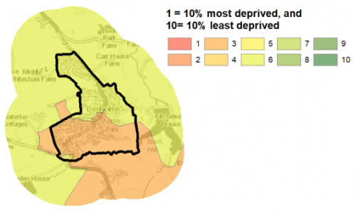
5.20.3 The Local Plan settlement hierarchy identifies Denholme as one of the district's 11 Local Service Centres. This means that it will see a smaller scale of development, comprising both market and affordable housing, as well as the protection of its local centre to help ensure the continued provision of economic activity in the area. In terms of deprivation, the southern part of the village suffers from moderate levels of overall deprivation. Figure 2 shows the general area.
Figure 2: Index of Multiple Deprivation Levels
Economy and Employment
5.20.4 Economic activity rates are relatively positive for Denholme with 73.4% of the resident population economically active compared to the West Yorkshire average (68.5%). Average household income at £39,400 is just slightly higher than the West Yorkshire average (£38,499). The main employment sectors that the residents of Denholme work in include retails, health and social work and manufacturing. There are limited employment opportunities within the village itself following the closure of many of the industrial and manufacturing businesses in recent years. Existing employment is mainly made up of the village's retail outlets and the service economy e.g. the local primary school. However, just outside the village along the A629, Halifax Road and situated within the Green Belt, is the Denholme Business Centre which houses a number of small businesses and provides potential employment opportunities to local residents. In order to access a wider range of employment opportunities, residents need to commute to the larger centres of Bradford, Keighley and Halifax.
5.20.5 Business Register and Employment Survey (BRES) data indicates that the three largest industry groups by workforce jobs (all people in employment) are: retail industry (21.9%), education (13.7%), and hotels and catering (9.2%).
5.20.6 The local plan does not seek to specifically allocate employment land within this Local Service Centre, but the plan is supportive of appropriately sited and scaled economic growth and diversification within the Pennine Towns and Villages.
Retail
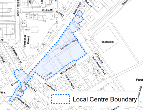
5.20.7 The 2019 Retail and Leisure Study concluded that Denholme is a healthy centre and notes the important role it plays in catering for the daily functions and immediate needs of the local population. The centre contains 14 units and is focused around High Street. The main convenience uses consist of the Co-op food store, and this is supported by an off-license and bakery. There is also a pharmacy, general goods store, charity shop, Post office and hair dressers. The boundary of the local centre is identified in figure 3 below.
Figure 3: Denholme Local Centre
Transport and Access
5.20.8 Transport connections for Denholme are focussed around the road corridor of the A629 linking Halifax and Keighley. Car ownership in the settlement is relatively high with around 75% of households having at least one car. This is slightly higher than the West Yorkshire average (70%) and reflects the rural nature of the settlement with a more limited number of public transport options and a smaller range of retail outlets and facilities, meaning residents have to travel further to access such services.
5.20.9 The village benefits from two bus routes: i) the 67 – run by The Keighley Bus Company (part of the Transdev Blazefield Group) which provides an hourly service running between Bradford and Keighley; ii) the 502 – run by Yorkshire Tiger which provides an hourly service running between Halifax and Keighley.
5.20.10 The nearest railway station is located around 7km to the north east at Bingley. Services from Bingley provide connections in to Bradford, Leeds and beyond and also up to Keighley and Skipton. Similar to other outlying villages, there is on average a higher percentage of multiple car ownership than the West Yorkshire averages.
5.20.11 There are numerous footpaths and bridleways leading out of the settlement into the countryside and connecting with the wider public rights of way network. Proposals for an extension of the Great Northern Railway Trail which would connect the existing sections of the route between Thornton and Denholme are supported in the plan with the route safeguarded for when funding allows implementation.
5.20.12 In relation to digital accessibility, average broadband download speed in Denholme is almost 54 megabytes per second which is above the West Yorkshire average of 44.57. There are 47 premises where speeds are below the Universal Service Obligation (USO)[1].
Planning for Homes
5.20.13 There are 1,230 dwellings within the settlement area. A large proportion of these properties are owner occupied (67.8%) slightly above the West Yorkshire average (63.4%). Social rented households equate to 16% of the total tenure (slightly lower than the West Yorkshire average at 18.8%).
5.20.14 There are a mix of house types in Denholme with the highest proportion being mainly older terraced properties located around the centre of the settlement (38.9%) and semi-detached (32.6%). Semi-detached and detached dwellings tend to be the dominant dwelling type in the newer housing estates to the south west and north east.
5.20.15 The average house price (all types) in Denholme is £131,000 which is well below the West Yorkshire average of £183,194. The average house price is below sub-regional figures for all house types as detailed below in figure 4
Figure 4: Denholme - House Prices
|
Average house price (all types of housing) (Land registry Sept-19 to August-20) |
Average house price (detached) (Land registry Sept-19 to August-20) |
Average house price (flats) (Land registry Sept-19 to August-20) |
||
|
£131,000 |
£240,000 |
£52,000 |
||
|
West Yorkshire average = £183,194 |
West Yorkshire average = £324,872 |
West Yorkshire average = £128,299 |
||
|
Average house price (semi-detached) (Land registry Sept-19 to August-20) |
Average house price (terraced) (Land registry Sept-19 to August-20) |
Households in Council Tax Band A (Valuation Office Agency (VOA) 2020) |
||
|
£144,545 |
£81,421 |
526 |
||
|
West Yorkshire average = £178,439 |
West Yorkshire average = £132,430 |
39.3% (West Yorkshire average = 43.1%) |
||
|
Households in Council Tax Band B (VOA 2020) |
Households in Council Tax Band C (VOA 2020) |
Households in Council Tax Band F-H (VOA 2020) |
||
|
265 |
249 |
48 |
||
|
19.8% (West Yorkshire average = 20.2%) |
18.6% (West Yorkshire average = 17.6%) |
3.6% (West Yorkshire average = 4.3%) |
5.20.16 The delivery of new housing is a key part of the development strategy for Denholme. This will ensure that the housing needs of local people can be met, both in terms of market and affordable housing. New housing will also allow for the modest growth of the settlement, to attract new residents and to help sustain the provision of services and facilities.
5.20.17 Policy SP8 in the local plan sets out a minimum requirement of 80 dwellings to be delivered in Denholme during the plan period. These will be delivered through a mix of committed sites (those under construction or have planning permission but have not yet commenced) and new allocations. Table 1 below sets out the housing position for Denholme, which also includes the application of non-implementation or discount rates for planning permissions and allocations.
Table 1: Denholme - Summary of Housing Requirement and Supply
|
Housing Target |
80 units |
|
Carried Forward Commitments |
17 |
|
Commitment Discounted by 10% |
15 |
|
Remaining Allocation Requirement |
65 |
|
Identified Allocations |
72 |
|
Allocations Discounted by 10% |
65 |
|
Total Supply Contribution from Allocations |
65 |
5.20.18 Once the commitments are discounted and removed from the supply, this leaves a residual allocation requirement of 65 units. The evaluated total site supply of housing units from the preferred allocation site equates to 72 units which is in turn discounted by 10% for non-implementation or under delivery leaving a final allocation contribution of 65 units.
5.20.19 One medium sized brownfield site at Station Road has been identified as the preferred housing option for Denholme to meet the housing requirement. Further information on this proposed allocation is set out in Table A and identified on the Policies Map and the Site Pro Forma below together with the local strategies map for each plan area. Development of site allocations should be in accordance with specified development guidelines and approximate site provision figures and all other relevant policies of this Local Plan. The Council considers that the proposed level of growth within this area can be met without any need to make change to or release land from the green belt. The Council will be supportive of additional proposals for new homes on additional small sites, particularly those that provide a redevelopment opportunity to bring forward land which has been previously used. Support will also be provided to developers who wish to redevelop larger sites and/or buildings for new homes not currently identified, subject to all relevant policies in the Local Plan.
Planning for Places and Communities
Green Belt, Natural Landscape and Historic Character
5.20.20 Denholme is surrounded by the Green Belt which forms a tight boundary with the built-up area, leaving little room for further expansion of the settlement. There are three landscape character types which surround Denholme. The dominant Landscape Character type is Mixed Upland Pasture and this covers land to the North, South and East. This landscape has a reasonably strong, visible and open character that could be sensitive to change. On the western edge of the village there is an area covered by the Parkland landscape type. This unique area of landscape is characterised by densely wooded areas, high stone walls and enclosed areas of pasture. It is of strong character with high historic continuity, visible and enclosed characteristics, but is only moderately sensitive to change. To the south west there is an area of upland pasture which again has a strong character, is visible and open, and could be sensitive to change.
5.20.21 Denholme has a limited number of heritage assets, with just four Grade II listed buildings/ structures within its settlement limits. In term of other heritage designations, Denholme has no conservation areas, no scheduled monuments, and just a small number of known archaeological sites.
Green Infrastructure(GI), Ecology, Open Space and Flood Risk
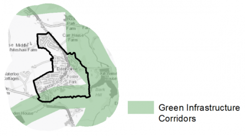
5.20.22 Areas to the east and south of Denholme form part of the District's Green Infrastructure network and should be protected and enhanced. These areas are multi-functional in nature and help to deliver benefits for biodiversity, reduce flood risk, provide public rights of way, and areas of open space. New developments should identify the opportunities to connect into these networks by enhancing natural features that exist on-site and improving the links between sites. Figure 5 shows the location of these.
Figure 5: Green Infrastructure Corridors
5.20.23 There are a number of wildlife sites and priority habitats in and around Denholme. Two key sites are Carperley Beck and Doe Park Reservoir. These are Local Wildlife Sites and provide residents with the opportunity to connect with nature. A number of sites and areas to the east of the village help to form a wider Wildlife Habitat Network – connecting spaces together to allow for the movement of species. These networks are formed of semi-improved acid grassland, broad-leaved and lowland deciduous woodland, scrub and grassland.
5.20.24 The South Pennine Moors SPA/SAC is situated close by, to the south and west meaning that Denholme falls within the 2.5km zone of this Internationally designated wildlife habitat. This zone has been identified as the area most frequently utilised by SPA qualifying species for foraging.
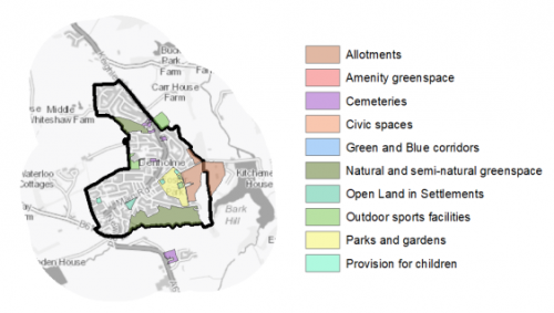
5.20.25 The 2020 Open Space Audit shows that Denholme has a good amount and range of provision. Key open space assets in the settlement include Foster Park, Carperley Beck, and Foster Park View Allotments. Figure 6 shows the location and type of open space in the village. The audit highlights that the priority for any new open space should be for amenity greenspace and outdoor sports provision.
Figure 6: Denholme – Open Space Overview
5.20.26 The main urban area of Denholme is located on the hillside which runs downhill to Carperley Beck meaning that most properties are not at risk of fluvial flooding. There are small parts of the settlement, particularly to the south west where there is potential for surface water flooding to occur due to the topography and permeability of surfaces in that area. However, flooding on the whole is not a major constraint to development in Denholme.
Community Infrastructure – Education, Health and Utilities
5.20.27 Denholme has a limited number of community facilities available to meet the day to day needs of local people. These mainly consist of local shops, a library, parks and play areas, places of worship and public houses. For a more varied mix of facilities such as sport and leisure centres and a greater choice of shops, residents would need to travel further afield in to the regional city of Bradford or the principal towns of Bingley or Keighley to access such services.
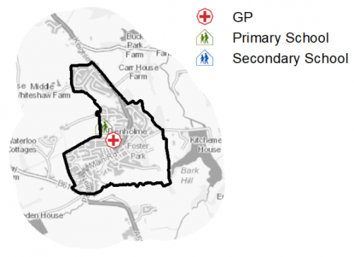
5.20.28 Denholme Primary School is a single form entry school which is part of the Nurture Academies Trust. The nearest secondary provision is found at Parkside School in Cullingworth, or Beckfoot School in Thornton.
5.20.29 There is one GP surgery located on Ann Street offering primary care services to local residents. This Practice is part of the Denholme and Thornton medical practice and is only open limited hours. Secondary (acute) healthcare is provided at Bradford Royal Infirmary,
around 8km east of the village. There is also a pharmacy within the village. The location of local services are shown in figure 7.
Figure 7: Denholme – Schools and GP Practices
5.20.30 When planning for the long-term development of Denholme, it is vital that new development is supported by the appropriate infrastructure. The capacity, quality and accessibility of services and facilities are all key components in ensuring people can enjoy living, working and visiting the area. The council will continue work with key infrastructure providers and others including the Local Education Authority, Clinical Commissioning Group and utilities providers to determine the impacts of future growth and development on local infrastructure capacity and provision. Further infrastructure details will be published through the Local Infrastructure Plan and as part of the Regulation 19 stage of the local plan.
|
Local Area Strategy and Plan - Denholme The key elements of the local area strategy for Denholme include:
|

(2) Consultation Question 126
Denholme Local Area strategy and Plan
Q. Please provide any comments you may have on the area strategy?
If you have an alternative to the approach undertaken, please provide further details and evidence in support.
Preferred Site Allocation and Site Pro Forma
5.20.31 The preferred housing site allocation is detailed below in Tables A. This table is subsequently followed by site pro forma providing a summary of key site information and characteristics.
Table A: Housing - Preferred Allocation
|
Site Ref |
Site Name |
Dwellings |
|
DH1/H |
Station Road |
72 |
|
Total |
72 |
(2) Consultation Question 127
Denholme Site Allocation and Site Pro Forma
The Local Plan sets out a preferred site allocation for Denholme. If you wish to make representations on the site proposed, please provide feedback under this question.
If you wish to propose an additional or alternative site(s) to the preferred allocation listed, please also provide a plan with a red line and any further details in support.
[1] Universal Service Obligation (USO) - download speeds at or above 10Mbit/s and upload speeds at or above 1Mbit/s including non-matched records and zero predicted speeds
(4) DH1/H - Station Road
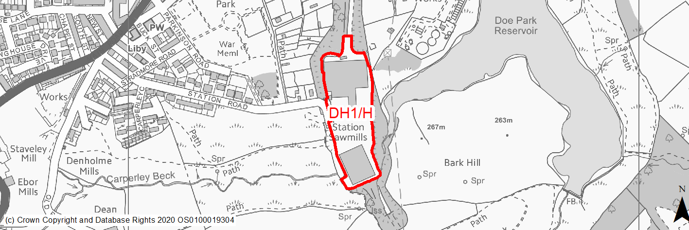
Site location
Local Service Centre - Denholme
Ward
Bingley Rural Ward
Site description
This site consists of a former timber merchants which has now been cleared. The site is relatively flat with large areas of concrete hardstanding. The site boundaries are mainly formed of strong tree lines and other vegetation.
Proposed Allocation
Housing
SHLAA referencce
DH/016
Indicative no. dwellings
72
Site area (Gross) (ha)
2.15
Ownership
Private
Delivery timescales
Deliverable (0-5 years)
Type (PDL/Greenfield)
PDL
Green Belt
No
Flood Zone
Flood Zones 2 and 3 cover a small area of the southern part of the site.
Potential site access
Existing access off Station Road - some improvements will be required.
Public Transport Accessibility
The site is over 400m from a bus stop offering a service of 2 buses per hour.
Sustainability Appraisal
The site could deliver a major positive effect for residents on the health SA Objective as a result of being within the target distances for all necessary health facilities.
A significant adverse effect arises for the climate change resilience SA Objective due to the presence of a band of land in the active flood zones FZ2 and FZ3 in the south of the site, and a very limited area of land at high risk of surface water flooding. More detailed flood risk assessments would likely be required for the site and careful consideration given to the layout of the development.
Minor positive effects were predicted for most socio-economic themed SA Objectives due to the benefits of new residential development for the local economy, as well as the location of the site in relation to local services and amenities, education facilities and employment areas.
The site appears to be vacant PDL, so residential development here could be an efficient use of land and provide opportunities to enhance the local townscape character and deliver biodiversity net gains. However, two areas of deciduous woodland priority habitat and Carperley Back LWS adjoin the perimeter, which could be impacted by the development. Carperly Beck is adjacent to the site and Doe Park Reservoir is 25m east of the site, meaning careful consideration around protecting water quality would be required.
Habitats Regulations Assessment
This site falls within 2.5km of the South Pennine Moors SPA/SAC a HRA must be undertaken to ensure there are no significant effects on these protected sites in terms of impact on supporting habitat which might be functionally linked to the SPA and recreational pressures. Developments within these zones must comply with Policy SP11; an SPD is being produced to provide further guidance.
Green Belt
N/A – Site not within the Green Belt.
Constraints and Opportunities
• This is a previously developed site and provides an opportunity to regenerate this part of Denholme.
• The site is located in a Green Infrastructure corridor.
• There is an area of surface water flood risk in the centre of the site.
• The site is located within the 2.5km buffer of the SPA/SAC.
Development considerations
• The design should incorporate Green Infrastructure to aid the connectivity of existing assets.
• Mitigate of any surface water flooding or drainage issues will be required.
• Vehicular and pedestrian access is available off Station Road.
Conclusion/Summary
This is a level, previously developed site, sustainably located within the setttlement boundary and near to a number of local services including open space and shops. The site could deliver an estimated 72 dwellings and has recently obtained planning permisision.