
Draft Bradford District Local Plan - Preferred Options (Regulation 18) February 2021
2.0 Introduction
2.1 What is the Local Plan?
2.1.1. Planning involves making decisions about the future of our cities, towns and countryside – where we work, where we live, where we play and how we are able to get to these destinations. It involves planning ahead to ensure that services, utilities and infrastructure are available where they are needed and attempting to balance different needs and goals ranging from our desire for development, growth and regeneration to our desire to protect and conserve and enhance our built and natural environment. We need to achieve a strategy for sustainable development that meets the needs of the present without compromising the ability of future generations to meet their own needs.
2.1.2 Plan-making also involves the process of building evidence, combining research and analysis with engagement and consultation with all who have a stake in making our district a great place and in the process producing a framework of policies and proposals to guide future decisions on where development will take place and in what form. Plan-making also involves making clear decisions about a spatial strategy and locations for new homes, employment and other uses. Ultimately, plan making is aimed at creating sustainable and vibrant communities and places.
2.1.3 All Councils are required by law to produce a statutory development plan for their area and Government has set a deadline of December 2023 for all local planning authorities to have an up-to-date local plan. This integrated local plan marks a departure from the current portfolio plan approach of the adopted Core Strategy and suit of development plan documents and builds upon work started on the partial review of the Core Strategy in 2019[1]. The review was stimulated by a number of major changes to the national planning policy framework including the approach to assessing housing need and setting housing requirements; the continued protection and enhancement of Green Belt, and local policy changes including the adoption of a new economic strategy for the district and a focus upon ensuring the plan contains sufficient focus upon major transport projects and regeneration opportunities.
2.1.4 The issues explored through the partial review of the Core Strategy and publication of the Preferred Options report in July 2019 set the benchmark for many of the policies within this integrated plan. The extent of the policy work has been naturally extended to encompass a full range of policy and site considerations including those currently addressed through the adopted area action plans and waste development plan documents together with a strengthened focus upon the role of land use planning in tackling climate change and setting a positive path towards a lower carbon future. The overall key directions of the plan have been explored earlier in section one and include:
- Supporting a green recovery and balanced growth
- Continuing to maximise our regeneration opportunities
- An integrated District-wide approach to local planning
- Delivering high quality neighbourhoods and housing
These themes are embedded throughout the plan and are particularly relevant to the vision and strategic objectives contained within this section of the plan.
2.1.5 The intention of the integrated local plan is to provide a comprehensive policy and spatial framework together with supporting site allocations over a 15 to 20-year timeframe of delivery, which is underpinned by a comprehensive approach to infrastructure planning, supporting both growth and regeneration. The plan is also intended to give some certainty to communities and development industry over the location of development and provide a local planning policy framework for communities that are producing Neighbourhood Plans.
2.1.6 The Local Plan is being prepared at a time when the Government is looking to make major changes to the planning system in England. There is a particular focus on simplifying the plan-making process. In recognition of this, the Local Plan is moving to a single plan document structure and seeking to have a greater focus on place-based planning. This is articulated through the Local Area Plans and Strategies (see section 5)
2.1.7 Further details relating to the Local Plan system are provided on the governments Planning Portal http://www.planningportal.gov.uk and a full Glossary of Terms and Acronyms can be found in the Appendix 1 of this document.
2.2 Plan-Making Stages
2.2.1 The process and stages to producing local plans is set out in the planning regulations and are designed to ensure that by the time the local plan is finalised it has been tested through extensive consultation and involvement of the public and wider stakeholders and all reasonable policy and strategic options have been considered.
2.2.2 Figure 2.1 below identifies where the current consultation plan is in terms of the overall process and provides an overview of the plan-making stages to Examination in Public and likely stages beyond with adoption likely in late 2022 or early 2023. The Local Development Scheme (LDS) which sets out a rolling programme of the details, timescales and arrangements for producing Local Development Documents is in the process of being formally approved to reflect the new plan-making process. A technical note has been published on the Council's website for further information.
Figure 2.1: Plan-Making Stages

2.3 Local Plan and Neighbourhood Plans
2.3.1 The local plan forms part of the overall statutory development plan for the Bradford District area alongside made neighbourhood plans. Planning law requires that applications for planning permission be determined in accordance with the development plan, unless material considerations indicate otherwise. Adopted neighbourhood plans therefore also play an important role when it comes to decisions about planning applications and at a more fundamental level can be used to articulate the spatial vision, aims, local policies and proposals for an area plus allocate sites. In line with national planning policy neighbourhood plans should support the delivery of strategic policies contained in local plans or spatial development strategies; and should shape and direct development that is outside of these strategic policies. Neighbourhood plans should not promote less development than set out in the strategic policies for the area, or undermine those strategic policies.
2.4 National Planning Policy Framework
2.4.1 The current version of the National Planning Policy Framework (NPPF) was published in February 2019 and contains the government's planning policies for England and how these are expected to be applied, including the Local Plan and Neighbourhood Plans. The Framework should also be read in conjunction with the Government's planning policy for traveller sites, and its planning policy for waste and national policy statements for major infrastructure.
2.4.2 The Local Plan has been prepared in accordance with the NPPF and advice on traveller sites and waste and within The Town and Country Planning (Local Planning) (England) Regulations 2012. It is noted that Government has made changes to the current planning system in relation to the standard method for assessing local housing need which is discussed under relevant policy areas within this plan and has consulted on other changes to the current system (First Homes, changes to affordable housing thresholds and extending the current Permission in Principle process), which have not been finalised at the time of drafting[2].
2.4.3 Further ideas in relation to deep-rooted changes to the planning system where published by Government through the 'Planning for the Future' White Paper in 2020.[3] As mentioned previously the move to a single plan document structure and more local area based approach to planning is partly informed by Government directions. Despite the potentially significant changes to the planning system, Government has reinforced its support for a plan-led system and stipulated that councils need to have up to date local plans in place by December 2023.
2.5 Plan Development – Appraisals and Assessments
2.5.1 The Local Plan is supported by a number of key appraisal and assessment documents which help inform the direction of the plan. These include:
- Sustainability Appraisal and Strategic Environmental Assessment (SA)
- Habitat Regulations Assessment (HRA)
- Equalities Impact Assessment (EqIA)
- Health Impact Assessment (HIA)
Sustainability Appraisal and Strategic Environmental Assessment (SA)
2.5.2 The Council, as the local planning authority (LPA), is legally required by Section 19 of the Planning and Compulsory Purchase Act 2004 to carry out a Sustainability Appraisal (SA) of their Plans. The Town and Country Planning (Local Planning) (England) Regulations 20122 dictate that after adopting a plan the LPA must make the SA Report available.
2.5.3 The SA is a mechanism for assessing the extent to which an emerging plan promotes sustainable development by applying a holistic assessment of the likely effects of the plan on social, economic and environmental objectives.
2.5.4 The SA is an iterative process and, over several stages and potentially multiple SA Reports, will help the Council with achieving sustainable development in their plan-making. This is by predicting and evaluating the likely sustainability impacts (including environmental, social and economic impacts) of options being considered for the Local Plan (including individual impacts and cumulative impacts) so the Council can make informed choices over what policies and development to pursue in their Plan. The SA also provides recommendations to the LPA which, if adopted, would help to avoid or mitigate any likely adverse sustainability impacts of options or alternatively would help to enhance the likely positive sustainability impacts. It is expected that the SA will make a meaningful contribution towards ensuring that the Local Plan delivers sustainable development in Bradford alongside other evidence documents being prepared by the Council.
2.5.5 The SEA is a legal requirement set out in The Environmental Assessment of Plans and Programmes Regulations 2004 (the SEA Regulations). SEA is a systematic process designed to provide for a high level of protection of the environment and to contribute to the integration of environmental considerations into the preparation and adoption of plans and programmes with a view to promoting sustainable development
2.5.6 An interim SA has been produced to accompany this Regulation 18 consultation on the Local Plan, which builds upon the policy content first evaluated through the Core Strategy Partial Review.
Habitat Regulation Assessment (HRA)
2.5.7 The South Pennine Moors, represented by Rombalds Moor to the north of the District and Haworth Moor to the west of the District have been designated as Special Protection Area (SPA) due to the importance of its breeding bird population. The South Pennine Moors are considered as a significant environmental resource. Designated originally under the European (EU) Directive for Wild Birds (known as Wild Bird Directive) 79/409, the SPA covers an area of 4295 hectares and is an internationally important site for large breeding number of Merlin (Flaco columbarius), golden plover (Pluvialis apricaria) and twite (Carduelis flavirostris).
2.5.8 The South Pennine Moors site is additionally designated as a Special Area of Conservation (SAC) and was originally designated under the EC Habitats Directive for habitat types and species identified within Annexes I and II of the Directive.
2.5.9 Under the transposed habitat regulations, the Council is required to undertake an Appropriate Assessment of the policies and proposals in the plan, to ensure that these would not lead to adverse effects on the ecological integrity of internationally important habitats or species within or close to the district; particularly in relation to the South Pennine Moors. The assessment has concluded that the Local Plan could have adverse effects on the protected habitats and associated birds due to the extent of development located close to the moors and through increases in population. This has informed several policies as well as distribution and scale of development proposed in order deal with potential adverse impacts.
2.5.10 A HRA has been undertaken to accompany this stage in the development of the Local Plan.
Equalities Impact Assessment (EqIA)
2.5.11 The Council has a duty under the Equality Act 2010 to carry out an Equality Impact Assessment (EqIA) for all plans, strategies and proposals in order to eliminate unlawful discrimination, promote equality of opportunity and promote good relations between people of different equality groups. The protected characteristic groups include age, disability, gender reassignment, religion/belief, pregnancy and maternity, sexual orientation and sex; all of which are considered to be at particular risk of discrimination. The Council has published an EqIA to accompany this Local Plan.
Health Impact Assessment (HIA)
2.5.12 The Local Plan has been informed by a Health Impact Assessment (HIA) which is not a formal requirement. The HIA assesses the potential, positive and negative, health impacts of the plan on the population of the District. The Health Impact Assessment has been issued alongside the Local Plan for information.
2.6 Plan Specific Evidence
2.6.1 The NPPF is clear that the preparation and review of all policies should be underpinned by relevant and up-to-date evidence. This should be adequate and proportionate, focused tightly on supporting and justifying the policies concerned, and take into account relevant market signals. This plan is published with an updated set of evidence which are briefly outlined below:
Strategic Housing Market Assessment (SHMA) Update 2021
2.6.2 Updates the SHMA (2019) report to take account of the issuing of the Government's latest Standard Method for assessing local housing need and updated demographic evidence. The original SHMA study commissioned was commissioned to provide an evidence base for estimating local housing need and demand across the District, consider future demographic trends, and identify the housing requirements of specific groups such as BME households, first time buyers, families with children, people with disabilities and older people.
Bradford District Updated Demographic Evidence (2020)
2.6.3 A study in support of the SHMA to provide further insight into how local housing need calculated using the Government's Standard Method, and employment growth in Bradford aligns with the latest demographic evidence and forecasts.
Gypsy and Traveller Needs Assessment (GTNA) Update (2021)
2.6.4 Additional surveying and primary research into Gypsy and Traveller accommodation requirements, which builds upon previous evidence - Traveller and Travelling Showperson Accommodation Assessment - undertaken as part of the SHMA 2019.
Future Employment Analysis (ENALR Addendum (2021)
2.6.5 Review and update to the ENALR in relation to employment forecasts and translated findings for employment land need. Sense check and analysis in relation to latest regional econometrical modelling and macroeconomic trends. Also aligns with demographic and SHMA work programmes.
Bradford District Open Space Needs and Demand Study (2020)
2.6.6 The study identifies the views and expectations of local residents, communities and key stakeholders on the provision of open spaces across Bradford District. This is intended to achieve an in-depth understanding of local views about existing provision, the quality and accessibility of sites, perceived deficiencies and expectations for additional and/or improved provision.
Bradford District Open Space Assessment (2020)
2.6.7 Major study covering a full detailed and district-wide review of the status of open space supply integrating findings from the open space needs and demand study. Work leads to standard setting to inform planning policy and identification of area strengths and weaknesses in the provision of open space types.
Heritage Impact Assessments Technical Note and Appraisals (2020)
2.6.8 Pilot series of heritage impact assessments with supporting technical note based upon best practice and partnership working with Historic England. Further work to be progressed as part of final site decisions.
Bradford District - Selective Green Belt Review (2020/21)
2.6.9 Package of studies including : i) a review of the performance of strategic Green Belt parcels against the five purposes of the Green Belt as set out in national planning policy; ii) a review of settlement level growth and distribution options where applicable iii) a detailed site specific review of the impact of removing potential allocation sites on the fundamental purposes of the Green Belt; iv) ongoing review of the cumulative impact of releasing potential allocation sites within the Green Belt; v) ongoing assessment of the potential Green Belt release sites in terms of contribution to sustainable development and proximity to local services and facilities; vi) scope to reduce and mitigate harm to the Green Belt to the lowest reasonably practical extent.
Bradford District Sites Assessment Methodology and Report (2021)
2.6.10 Detailed site assessment methodology for housing and employment sites followed by information on appraised sites. Consists of several supporting appendices.
Bradford District Strategic Land Assessment (SLA) (2020)
2.6.11 Significantly updated strategic review of housing and employment land. Supersedes previously published versions of the Strategic Housing Land Availability Assessment (SHLAA) and also integrates employment land analysis.
Flood Risk Technical Note (2021)
2.6.12 Technical note setting out the current status of the work programme on the Bradford District's Level 1 Flood Risk Assessment.
Bradford District Local Infrastructure Plan (LIP) Update (2021)
2.6.13 Working document and update to current infrastructure evidence - cuts across a number of key infrastructure planning themes including education, transport, and utilities. Theme led publication with infrastructure schedules including initial gap analysis. Publication is updated throughout the development of the local plan.
Whole Plan Viability Assessment (Part 1) (2019)
2.6.14 Study assesses the viability impact of emerging planning policies and provides advise on affordable housing levels with regard to site types and value variables across the District. Work has been used to inform affordable housing policy, overall viability considerations and testing s.106 / CIL values.
Local Insight – Area and Settlement Guides (2020)
2.6.15 Wide range of area or settlement specific socio-economic statistical guides – used to inform area / settlement profiles and identify key local issues.
2.6.16 The evidence based with be further developed to assist with finalising the Regulation 19 Plan. Key elements of this work include:
- Strategic Transport Modelling and Transport Assessments.
- Transport Strategy.
- Updates to various studies including viability, housing, employment and infrastructure (not an exhaustive list).
- Potential updates to ecology information.
- Further technical work on heritage impacts.
- District Energy Strategy.
- Updated technical evidence on minerals and waste.
- Strategic Flood Risk Level 1 and Level 2.
- Various masterplans with supporting material.
2.7 Infrastructure Planning and Delivery
2.7.1 There is a clear need to support housing and economic growth with the right infrastructure at the right time and new development will be expected to make the best use of existing infrastructure, where sufficient capacity existing accommodate needs. Where improvements to existing infrastructure are required, new development will normally be expected to meet the costs of such infrastructure, along with providing any additional infrastructure requirements arising from the development.
2.7.2 The Local Plan is being developed at an important time for the future of Bradford City with a clear focus from the Council in improving connectivity and attracting investment in the form of Northern Powerhouse Rail (NPR) and Mass Rapid Transit (MRT). This scale of infrastructure investment has the potential for transformative change for the future of the city and can provide a catalyst for housing and economic growth. Infrastructure investment is not only essential in supporting housing growth but critical in the stimulation of growth – essential for tackling Bradford's economic and deprivation challenges.
2.8 Alignment with Local Strategies
2.8.1 The Council produces a wide range of strategies and policy publications and the Local Plan forms part of a much wider portfolio of documents. There is an obvious need to ensure Council strategies align and are moving in the same direction in terms of policies and focus.
Council Plan
2.8.2 The Bradford Council Plan (2021 to 2025) is the authority's working document for what it wants to achieve to create as good a quality of life as possible for the people and communities of Bradford District. The current plan builds on some of the same priorities as the 2016 – 2020 plan but also looks to address some new major challenges the district will face in the coming years. These include responding to and recovering from the COVID-19 pandemic; and following the Council's declaration of a climate emergency, taking the steps we need to take to deal with that emergency and to continue to build on sustainable delivery.
2.8.3 The Local Plan, and it policies will have an important role in contributing towards the achievement of number of the Council Plan priorities and outcomes, in particular:
- Building a Better Future;
- Creating a Sustainable District;
- Better Skills, More Good Jobs and a Growing Economy;
- Decent Homes;
- Better Health, Better Lives; and
- Safe, Strong and Active Communities.
Housing Strategy
2.8.4 The Bradford Housing Strategy 2020 to 2030 "A Place to Call Home, A Place to Thrive" sets out the vision, priorities and approach to meeting the housing needs of the residents of Bradford District in ways that can contribute to a more productive and inclusive economy, address health and social inequalities, tackle the challenge of climate change and help build stronger communities. The strategy is jointly owned by the Council and the multi-agency Bradford Housing Partnership. Its objectives are:
- More Homes - We want to increase the supply of homes of the right type and quality and in the right locations to meet the needs and aspirations of our diverse and growing population
- Quality Homes and Neighbourhoods - Our homes and neighbourhoods should be sensitive to future environmental, demographic and technological change. We want high-quality homes in neighbourhoods where people want to live and thrive. We want new developments of the highest quality standards and existing homes retrofitted to create homes that are energy efficient and adaptable.
- Homes for All - We want to ensure that everyone has a place to call home and that vulnerable residents in our communities are supported to live independently.
2.8.5 The Local Plan is central to delivering these objectives and puts in place a statutory policy framework to do so.
Communities and Health
2.8.6 The Bradford District Partnership's (BDP) 'Stronger Communities Together' Strategy (2018-2023) focuses upon a shared vision:
'to make Bradford District a great place for everyone – a place where all our children have a great start in life, where businesses are supported to create good jobs and workers have the skills to succeed, a place where people live longer, and have healthier lives and all our neighbourhoods are good places to live with decent homes for everyone'.
2.8.7 Key priorities include equality of opportunity - addressing factors affecting economic participation and poverty including language skills and educational attainment; promoting greater interaction, dialogue and understanding between people from different backgrounds given the diversity of the population and the extent of residential and educational segregation; ensuring that people understand fully their rights and freedoms and their responsibilities; generating and connecting people to opportunities to participate in community and civic life and strengthening leadership and tackling crime and the fear of crime so that everyone feels safe.
2.8.8 Recent work by the Town Fund partnerships for Keighley and Shipley has been considered in developing the Local Plan and key priorities.
2.8.9 The Local Plan includes a focus upon regeneration, jobs and skills development together with helping create healthy safe places.
2.8.10 Bradford's new economic strategy – 'Pioneering, Confident and Connected' was one of the original drivers for the partial review of the Core Strategy and is embedded within the employment policies within the Local Plan.
2.8.11 The BDP 'Children, Young People and Families Plan 2017-20' sets out a vision and series of priorities for children, young people and families, how the plan will achieve these. There are particular Local Plan connections through health orientated policies to the strategy in relation to reducing health and social inequalities, including tackling child poverty and reducing obesity. There are also connections to this work to the'Connecting people and placefor better health and wellbeing - A Joint Health and Wellbeing Strategyfor Bradford and Airedale, 2018-2023', with its priorities focused upon giving children a great start in life; ensuring people in Bradford have good mental health and people in all parts of the District are living well and ageing well together with supporting the development of the district as a healthy place to live, learn and work. The Local Plan includes a significant focus upon creating healthy places including a major strategic policy focus.
Air Quality and Transport
2.8.12 Air quality is a key issue for the District. The Council is preparing an Air Quality Plan which will protect and enhance the health of everyone who lives, works or spends time in the district. The plan will show it plans to bring the levels of nitrogen dioxide within legal limits in the shortest possible time. Measures proposed include the creation of a Clean Air Zone (CAZ).
2.8.13 The Council is currently in the process of preparing a Bradford Transport Strategy 2040. This will sit alongside the West Yorkshire Transport Strategy 2040 and set out a vision for the future of transport within the district.
Sustainable Development
2.8.14 The Council's Sustainable Development Action Plan (2020 to 2021) was approved in March 2020. The plan sets out a package of measures to help tackle climate change while building a sustainable and prosperous economy that works in the interests of everyone and minimises waste and the use of finite natural resources. The proposed measures are in line with the UN's Sustainable Development Goals and will cut carbon and costs, help to reduce household bills through better energy efficiency, improve health and wellbeing and generate new jobs and sustainable economic growth through investment in a green economy.
2.8.15 The role planning system's role is to contribute towards the achievement of sustainable development[4]. Local Plans are an essential part of the system and are required by law to achievement of sustainable development[5], and its policies will set out a positive framework for doing so.
2.9 City Region, Duty to Cooperate and Partnerships
2.9.1 In preparing the Local Plan, it is essential to take account of the wider context of the Leeds City Region. The Council is a member of the Leeds City Region Local Enterprise Partnership (LEP) and the West Yorkshire Combined Authority (WYCA). The LEP is responsible for preparing the Leeds City Region Strategic Economic Plan (SEP) that provides the economic policy framework for the area, with a focus upon a number of key subjects including Skills and Employment, Digital, Transport, Green Infrastructure, Trade and Investment, and Housing, Regeneration and Infrastructure. WYCA is responsible for the preparation of West Yorkshire Transport Strategy and helping to deliver the SEP.
2.9.2 More recently, the Government announced a mayoral devolution deal for West Yorkshire. This involves giving a newly elected mayor and mayoral combined authority control over annual £38 million investment fund as well as new powers over transport, education and housing.
2.9.2 The Duty to Cooperate requires the Council to work closely with neighbouring local authorities such as Leeds City Council or Kirklees Council as well as a number of key public sectors bodies including the Environment Agency or Natural England. This means engaging with one another in an active, constructive and ongoing basis to address cross-boundary, strategic planning issues as part of preparing the Local Plan. This takes a variety of forms including holding regular meetings, collaborating on producing evidence to support the Plan or participating in various regional or sub-regional working groups.
2.9.3 The Council is required to produce a Statement of Common Ground with key partners. It is a written record of the progress made by council and partner bodies to address cross boundary, strategic planning matters, and documents where effective co-operation is taking place during the plan-making process. It is also a way of demonstrating at examination that Local Plans are deliverable over their lifetime, as well as being based on effective joint working across local authority boundaries
2.9.4 There is a significant history of collaboration within the Yorkshire and Humber region on strategic planning issues. This has continued through the Leeds City Region and between individual local planning authorities. The Council is a signatory to the Leeds City Region Statement of Common Ground. This sets outs the approach to joint working across the city region on planning matters.
2.9.5 In addition to the working across the city region, it is also essential to work with bodies that have that sub-national or national remits. The Council is working closely with Transport for the North (TfN) to bring Northern Powerhouse Rail (NPR) to the Bradford.
2.10 Plan Period
2.10.1 It is recognised that the local plan needs to provide both longer range strategic direction but also flexibility to ensure that plans take account of changing local circumstances and national policy. Para 33 of the NPPF indicates that policies in local plans and spatial development strategies should be reviewed to assess whether they need updating at least once every five years, and then be updated as necessary.
2.10.2 National planning policy therefore builds in a requirement for regular local plan reviews. Para 33 also indicates that: 'Relevant strategic policies will need updating at least once every five years if their applicable local housing need figure has changed significantly; and they are likely to require earlier review if local housing need is expected to change significantly in the near future'.
2.10.3 The NPPF is also clear that strategic policies should look ahead over a minimum 15-year period from adoption, to anticipate and respond to long term requirements and opportunities, such as those arising from major improvements in infrastructure (para. 22).
2.10.4 The timelines detailed in the CSPR preferred options consultation indicated a potential submission draft (Regulation 19) document by Summer 2020[6]. The development of the new fully integrated local plan to Regulation 19 standard is on a longer timeframe, with a submission draft document expected to be completed by the end of 2021. Further evidence work needs to be completed between Regulation 18 and 19, particularly in relation to transport assessments, flood risk and other technical work areas.
2.10.5 This would then indicate submission to Secretary of State with supporting papers in early 2022, with examination and modifications to progress through the year taking a plan adoption through to 2023. Government has set a requirement for all local authorities to have up-to-date local plans in place by December 2023.
2.10.6 In light of these considerations it is intended to maintain the plan start date from 1st April 2020 but extend the plan end date to 2038 to allow for a minimum implementation length of 15-years for strategic policies. The monitoring information which underpins the plan has been reset to 31st March 2020, which allows for updated forecasts for completion and delivery data.
Preferred Option:
Plan Period: 2020-2038
2.10.7 In finalising the preferred option a number of reasonable alternatives were considered and discounted:
- 2013-2035/36/37/38 – this alternative results in technically a plan period of at least 22 years but a significant proportion of the plan is already set in the 'past'.
- 2020-2035 – this alternative results in a 15-year plan period but the risk that if that plan is adopted in 2023, this will leave only 12 years for strategic policies.
- 2021-2038 – this alternative results in a 17-year plan period and 15 years for strategic polices (on adoption of the plan in 2023) – requires a roll forward of monitoring data to 31st March 2021 with related uncertainties – information would need to be estimated at this time.
- 2022-2038 – this alternative results in a 16-year plan and 15 years for strategic policies (on adoption of the plan in 2023) – but requires potentially up to two years of additional housing monitoring data up to the start of the plan period (2022), with related estimate uncertainties.
- 2020-40 – this alternative produces a long range 20-year plan with 17-year strategic policies (on adoption in 2022), however the further the plan period, potentially the more unreliable the data and would in practical terms with an exhausted supply of non-Green Belt land require the identification of additional Green Belt land to release to meet higher total housing need figures.
(179) Consultation Question 1
Preferred Option: Plan Period 2020-2038
The adopted Core Strategy plan period currently runs from 2013 and covers the 17-year period to 2030. National planning policy indicates that strategic policies should look ahead over a minimum 15-year period from adoption. The proposed plan period allows for a 17- year plan length and a forward view on strategic policies of 15 years from the date of anticipated adoption in 2023. A revised plan period of 2020-2038 is proposed.
Q1. Please provide your comments for the preferred plan period and any suggested changes? If you would support an alternative to the Preferred Option, please provide further details and evidence to support this.
2.11 District Portrait
2.11.1 An outline of the key features and characteristics of the District are set out below.
District Portrait
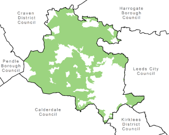
Bradford is a large metropolitan authority which covers approximately 370 sq km (143 sq miles) and forms one of the five districts within the West Yorkshire conurbation. The District is located within the Leeds City Region.
65% (23,880 hectares) of the Bradford District is covered by Green Belt.
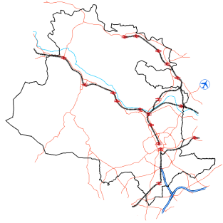
The District is located north of the M62 which is connected to it by the M606.
Two railway lines serve Bradford City Centre with regular services to Leeds and Manchester from Bradford Interchange and to Leeds, Ilkley and Skipton from Bradford Forster Square. There are also several direct services to and from London at both stations.
The Leeds and Liverpool Canal runs through the District via Shipley, Bingley, Keighley and Silsden.
Leeds Bradford Airport is located approximately 6 miles North East of the City Centre, just outside the District.

Bradford had a population of 539,775 in 2019 of which 49.3% were male and 50.7% were female. 127,915 (23.7%) were aged 0-15 which compares to 20.6% in West Yorkshire. 330,965 (61.3%) were aged 16-64 (working age population) which compares to 62.8% in West Yorkshire. 80,900 (15%) were aged 65+ which compares to 16.7% in West Yorkshire.
Source: 2019 Mid-Year Estimates (ONS).

In 2019, there was approximately 216,360 dwellings compared to 208,722 in 2013 representing an increase of 7,638 (3.7%).
The average house price is £158,753, compared to £183,194 in West Yorkshire.
Source: MHCLG, Dwelling Stock (2020)

At 31st March 2019, 69% of the population (aged 16-64) were active or potentially active (people working or available for work or training) members or the labour market. This compares to 77% in the Yorkshire and The Humber region. 66% of the working population (aged 16-64) is employed, compared to 74% in the Yorkshire and The Humber region. 4.8% of the economically active population are unemployed, compared to 4.6% in the Yorkshire and The Humber region.
Source: NOMIS, Official labour market statistics, Annual Population Survey (2019). Please note, these figures are pre-covid-19.
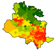
Bradford District is ranked 21st(previously 19th in 2015) most deprived local authority in England (1 is the most deprived and 326 is the least deprived).
Spatially, there are inequalities between urban and rural parts of the District, with the more deprived areas being found exclusively in the urban areas.
Source: MHCLG, Indices of Deprivation (2019)

Historic England have identified 2,287 listings of listed buildings in the Bradford District, 12 of which are recorded on the heritage at risk register.
Grade I = 23, Grade II* = 69, Grade II = 2,193
There are 59 Conservation Areas.
And 194 Scheduled Ancient Monuments.
Source: Historic England (2019)
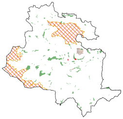
There are significant areas of the Bradford District which provide a valuable recreational resource as well as having landscape and biodiversity benefits.
There are 1,693 designated open space sites totalling 2,781 ha of land (covering 7.5% of the District).
One Special Protection Area (SPA) and Special Area of Conservation (SAC) (South Pennine Moors) totalling 4,488 ha (12% of the District).
Four Sites of Special Scientific Interest (SSSIs) totalling 4,498 ha (12% of the District).
Four Local Nature Reserves (LNR) totalling 17 ha (0.05% of the District).
108 Local Wildlife Sites (LWS) totalling 1,302 ha (3.5% of the District).
16 Local Geological Sites (LGS) totalling 250 ha (0.7% of the District).
Source: Natural England and Bradford Council, 2019.
Please note, some designations overlap.
(3) 2.12 Spatial Vision
2.12.1 Central to the Local Plan for Bradford District is the long-term spatial vision that provides the framework for the development of the policies within the plan. The vision is carried forward from the Core Strategy and includes a revision only to the plan period.
'By 2038 the Bradford District:
Has become a key driver of the Leeds City Region's economy and a much sought after and desirable location where people want to live, do business, shop and spend their leisure and recreation time. The District has demonstrated that it is a place that encourages sustainable lifestyle choices and responds positively to the challenge of climate change.
The growth of the City of Bradford and the towns along Airedale and Wharfedale has been supported by a significant increase in the delivery of new houses, both market and affordable. This growth has driven the economic and social transformation of the District. Sustainable development and management has been at heart of this growth and prosperity. The District's unique landscapes, heritage and biodiversity assets have played a vital role in making great places that encapsulates what makes Bradford so special.
Economic transformation of the District has been achieved based on Bradford's key strengths of its unique young, growing and international workforce as well as its culture of entrepreneurship, high quality places where businesses can thrive and its rich historic and cultural identity and wealth of environmental assets'.
(8) 2.13 Strategic Objectives
2.13.1 The following objectives indicate how the spatial vision for Bradford District will be delivered by the Council and its partners in making planning and investment decisions. Many of these objectives are identified as corporate priorities while others reflect priorities embedded with regional and national plans and programmes. The objectives carry forward changes indicated as part of the CSPR and a slight refresh in other areas to reflect the main directions in the Local Plan.
2.13.2 The objectives are specific, achievable, attainable and realistic in what they seek to achieve in order to fulfil the vision over the plan period. The Performance Framework of the Core Strategy and the Annual Monitoring Report will measure whether the Council and its partners are meeting the spatial objectives.
The Spatial Vision for Bradford District will be achieved through the following strategic objectives:
1. To recognise and fully exploit the role and transformational potential of the City of Bradford and the towns along Airedale and Wharfedale as dynamic locations of choice for housing and economic growth within the Leeds City Region.
2. To ensure that the District's requirements for housing, business and commerce are met in full in sustainable locations that reduce the need to travel and are well served by public transport and services, whilst prioritising, the use of deliverable and developable previously developed land. In so doing overcrowding within the existing housing stock should be reduced.
3. Ensure that the appropriate critical infrastructure (including green, social and technological) is delivered to support growth and the timing of development and infrastructure delivery are aligned.
4. To significantly improve the quality of new development and ensure that new housing schemes create inclusive, accessible, distinctive and healthy places that incorporate green streets and spaces and make efficient use of resources.
5. To provide a range of quality dwellings, in terms of type and affordability, in well-designed liveable neighbourhoods to cater for the current needs and future growth of the District and to ensure that the housing needs of all parts of the community including specialist needs are met.
6. To promote the role of the Bradford District in the Leeds City Region economy by creating conditions for housing growth, city living and enterprise where business thrives, generating opportunity, prosperity and jobs.
7. To promote and support a successful growing economy with a wide range of high quality employment opportunities, by fostering indigenous firms and by attracting inward investment in the green economy and high value technology, creative, innovative and knowledge based industries.
8. To promote, manage and develop the image and the role of Bradford City Centre as a regionally significant business, commercial, shopping, civic and cultural area.
9. To develop our skills, training and education base through new development and support the University of Bradford and the District's colleges and schools in investing in buildings and spaces to ensure a well-educated and skilled workforce.
10. To improve and develop excellent public transport and highway systems to increase the level of accessibility within the District and establish strong connections with other parts of the Leeds City Region and beyond through high speed rail connections and an integrated transit and public transport system ensuring safety, efficiency and sustainability.
11. To ensure that Bradford is a diverse city where socially inclusive and vocal communities live and where the needs of citizens are met through improved access to good quality homes, jobs, shopping, cultural facilities, health and education provision and community facilities for a growing population.
12. To provide a clean, safe, secure, sustainable, attractive and accessible built and natural environment in order to reduce the fear of crime and disorder and foster a shared sense of civic pride and responsibility, supporting the social, economic and physical regeneration of neighbourhoods across the District.
13. Safeguard, enhance and promote the diverse historic built and natural heritage of the District which helps reinforce the local distinctiveness of places.
14. To improve air quality and reduce the impact of climate change through mitigation and adaptation, particularly through reducing emissions, energy consumption, the risk of flooding, and promoting the use of renewable and low carbon energy and securing the means to become locally self-sufficient.
15. Provide accessible and varied opportunities for leisure and recreation including access to the countryside, provision of open space and the utilisation of green infrastructure spaces and routes for walking and cycling.
16. Ensure that new development provides a biodiversity net-gain and safeguards and enhances the District's biodiversity assets through careful landscape, woodland and waterways management. In particular the South Pennine Moors and upland fringe.
17. Safeguard and enhance the District's natural and renewable energy resources, including water, agriculture, woodland and minerals, and promote the sustainable management of waste and recycling.
18. To create and deliver healthy places in Bradford District that maximise health and well-being benefits for residents and visitors, provide opportunities for healthy lifestyles and reduce health inequalities.
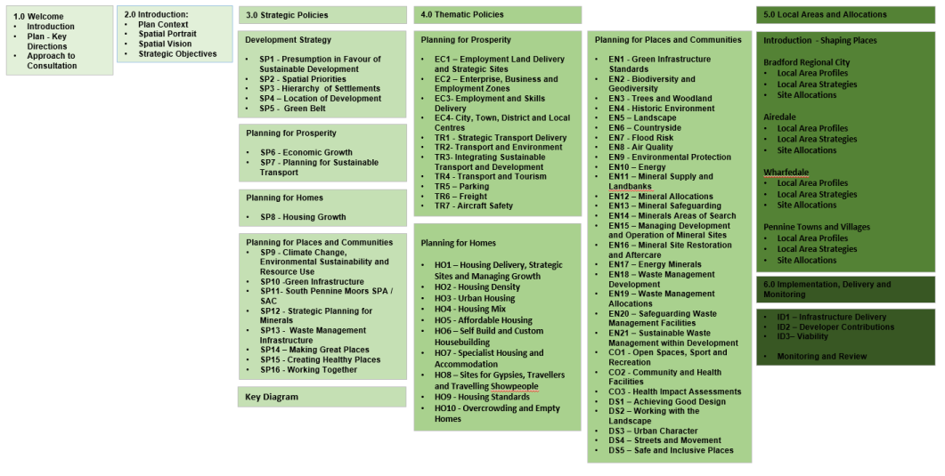
2.14 Plan Framework
2.14.1 The process of moving to a single plan structure has involved a redesign of a number of policy areas and integration of others plus the full 'move across' once reviewed and updated where necessary of policies and material from the Core Strategy, Waste Management DPD, Area Action Plans and RUDP. This has been a complex process, but in summary the main links back to previous editions of policies is set out in Appendix 2 for information.
2.14.2 The overall framework for the plan is set out below, which moves from strategic policies in section 3 through to thematic or more development management orientated planning policies in section 4. Section 5 of the plan drills down further and concentrates on local areas and settlements and provides detailed information on preferred site allocations. The plan is structured to facilitate questions and responses throughout.
[1] The Local Plan currently consists of the Core Strategy DPD (2017), Bradford City Centre Area Action Plan (2017), Shipley and Canal Road Corridor Area Action Plan (2017) and the Waste Management DPD (2017). The saved policies of the Bradford Replacement Unitary Development Plan (2005) are also part of the statutory development plan for the district.
[2] Changes to the current planning system - GOV.UK (www.gov.uk) and Government response to the local housing need proposals in "Changes to the current planning system" - GOV.UK (www.gov.uk)
[4] National Planning Policy Framework (NPPF) (February 2019) – Paragraph 7
[5] This is a legal requirement of local planning authorities exercising their plan-making functions (section 39(2) of the Planning and Compulsory Purchase Act 2004).