
Draft Bradford District Local Plan - Preferred Options (Regulation 18) February 2021
Baildon
Introduction
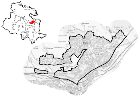
5.8.1 Baildon is a town located to the east of the Bradford District approximately 8km to the north of Bradford City Centre and 4.5km to the east of Bingley, 9km south-east of Ilkley, and 15km north-west of Leeds. It is situated on relatively steeply sloping land between the foot of Baildon Moor and the River Aire, which forms its southern and eastern boundary. It forms a continuous urban area with Shipley and Bradford.
5.8.2 Baildon Moor and Baildon Bank - a steep escarpment stretching into the settlement from its western edge allows for good long distance views south and westwards from its highest point across to Shipley and Saltaire and are prominent features in landscape. The built up area extends to Baildon Moor in the north-west, Tong Park in the north east and Baildon Bottom in the south-west. The settlement also includes the residential enclave based around Glenwood Avenue which is connected to the main body by Higher Coach Road.
5.8.3 The settlement is located within the Shipley Parliamentary Constituency and mainly within Baildon Ward. A section (Baildon South West) of the built up area is within the Shipley ward. Baildon officially took on town status in June 2013. Baildon Town Council acts as the administrative body for the town.
Figure 1: Location Map
5.8.4 Baildon is primarily a residential commuter settlement with good connections to nearby towns and cities including Leeds, Bradford and Shipley. There are a range of local services and facilities to meet the needs of the local population, which is estimated at 15,547 with slighter older age profile (24.6% aged over 65 years) compared to the West Yorkshire average (16.7%). The ethnicity of the population is primarily White British at 94.3% compared to a West Yorkshire average of 78.4%.
Planning for Prosperity
5.8.5 The Local Plan settlement hierarchy identifies Baildon as a Local Service Centre. The District's Local Service Centres and rural areas form the fourth element of the settlement hierarchy in the local plan (Policy SP3) and provide services and facilities that serve the needs of, and are accessible to, people living in the surrounding rural areas.
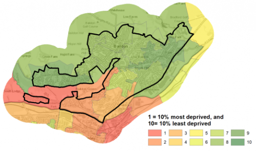
5.8.6 The Baildon local area scores significantly lower than the West Yorkshire average across all deprivation measures if measured by number of people in the area living within the 20% most deprived areas of England as ranked by the Indices of Multiple Deprivation. Figure 2 shows statistical comparisons with West Yorkshire and figure 3, the areas of deprivation.
|
Number of people in Baildon Sub Area living in the most deprived 20% of areas of England by Indices of Deprivation (ID) 2019 domain |
||||||||||
|
Index of Multiple Deprivation |
Income domain |
Employment domain |
Education domain |
|||||||
|
2,525 |
2,525 |
835 |
0 |
|||||||
|
16.2% (West Yorkshire average = 36.2%) |
16.2% (West Yorkshire average = 31.9%) |
5.4% (West Yorkshire average = 32.4%) |
(West Yorkshire average = 35.3%) |
|||||||
|
Health domain |
Barriers to Housing and Services domain |
Living Environment domain |
Crime domain |
|||||||
|
2,525 |
0 |
1,575 |
3,872 |
|||||||
|
16.2% (West Yorkshire average = 33.8%) |
(West Yorkshire average = 1.8%) |
10.1% (West Yorkshire average = 39.8%) |
24.9% (West Yorkshire average = 48.2%) |
|||||||
|
Source: Ministry of Housing, Communities and Local Government (Indices of Deprivation 2019) |
||||||||||
Figure 2: Indices of Multiple Deprivation
Figure 3: Baildon - Areas of Multiple Deprivation
Economy and Employment
5.8.7 Economic activity rates are also relatively positive for Baildon at 71.3% of resident population compared with 68.5% for the West Yorkshire average, with a higher percentage of full time employees and self-employed people than the sub-regional comparisons. Average household income at £42,513 is above the West Yorkshire average at £38,499. Incomes are reflective of job types with higher percentages of the local population working in managerial, professional and administrative / secretarial occupations.
5.8.8 Historically, Baildon was a centre of the woollen industry, however it has since become primarily a commuter settlement for nearby larger towns and cities including Bradford and Leeds. Employment development is centred on the Charlestown area of the town. This area is in the bottom of the valley of the River Aire between the A6038 Otley Road and the river. They consist of a mix of large retail units, trade counters, industrial/business units, workshops and factory units. Larger employers present in this area include DENSO Marston, H.C. Slingsby, Manor Coating Systems and Printcraft. This area is not included within the settlement boundary for Baildon. It falls within the Lower Baildon area which is being considered in tandem with Shipley as part of the Regional City of Bradford. The Tong Park Industrial Estate is located to the north of Otley Road adjacent to the eastern edge of the settlement. Other employment is available to the south of the River Aire in Shipley.
5.8.9 The Business Register and Employment Survey (BRES) data indicates that the three largest industry groups by workforce jobs (all people in employment) are manufacturing (24.3%), wholesale (7.8%) and health (7.6%).
Retail
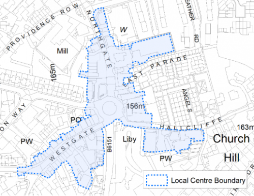
5.8.10 Baildon is designated in the retail hierarchy (Policy EC4) as a Local Centre. The centre is concentrated on the Towngate roundabout, Westgate and Northgate. The centre boundary is shown on the Policies Map and figure 4 below. The Retail and Leisure Study 2019 considered it to be a viable, well maintained and attractive centre with low vacancy rates, a high quality environment and good public realm.
5.8.11 The centre's convenience offer is anchored by a Co-op Food Store, whilst the comparison is varied covering a range of goods. Retail and leisure services are highlighted as being above the national average. These uses include hairdressers, beauty salons, an optician, several takeaways, restaurants and pubs. In addition, there are number of financial and business services present. The centre is also home to Baildon Library, the Ian Clough Hall and St. John's Parish Church. A bus station also located adjacent to the Martins store.
Figure 4: Baildon Local Centre
Transport and Access
5.8.12 Baildon is located on the northern edge of the key transport corridor running through the Aire Valley, providing good road and rail connections to nearby major towns and cities. It lies mostly to the north of A6038 Otley Road, which forms the southern edge of the settlement boundary. This route provides links to Shipley and Bradford (to the south) and Menston, Guiseley and Otley (to the north and north east). It is connected to the centre of Baildon by the B6151, which runs south from Browgate roundabout. Several minor roads run north from the town across Baildon Moor, providing links to Bingley (Eldwick) and Ilkley.
5.8.13 Public transport provision in Baildon is considered to be reasonable. Baildon railway station, located to the south-east, is on the electrified Wharfedale line and provides access to both Bradford Forster Square and Ilkley (2 trains per hour in each direction). Leeds can be reached via a change of train at either Guiseley or Shipley. The station's location towards the edge of the settlement poses problems in terms of accessibility for its users but both Saltaire and Shipley stations are also accessible from Baildon.
5.8.14 Although a frequent bus service runs (3 services per hour) runs from Baildon Towngate to Shipley and Bradford City Centre via the Knoll Estate and Baildon Green, much of the outlying town is not well served. There is also a more limited (hourly) service that links Lucy Hall Drive to Shipley and Bradford via the centre and east of Baildon. An hourly service between Bradford and Leeds Bradford Airport (via Guiseley and Yeadon) runs along A6038 Otley Road.
5.8.15 The Baildon area has higher levels of car ownership than the West Yorkshire average across all number of vehicles and consequently lower levels of households with no car at 19.7% compared to a sub-regional average of 29.4%. Baildon is not covered by an Air Quality Management Area (AQMA) and lies outside the proposed Clean Air Zone (CAZ).
5.8.16 In relation to digital connectivity, average broadband download speeds in Baildon is just over 55 megabytes per second – above the West Yorkshire average, whilst there are only 16 premises where speeds are below the Universal Service Obligation (USO)[1].
5.8.17 Strategic transport infrastructure projects to be delivered within the plan period and protected routes are set out on the Policies Map with the local plan.
Planning for Homes
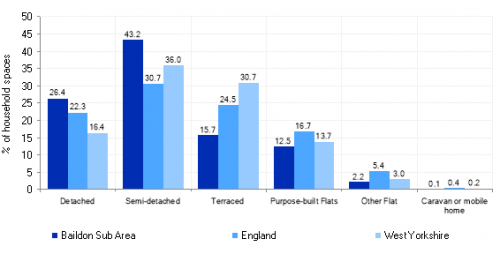
5.8.18 Baildon has 7,113 dwellings, with higher than sub-regional average number of detached and semi-detached properties, together with strong levels of owner occupancy (78.4% compared to 63.4% West Yorkshire average). The overall percentage of property build before 1900 (9.8%) is roughly half of the West Yorkshire average percentage. The dwelling type split for the Baildon area is detailed below in Figure 5.
Figure 5: Baildon - Housing Types
5.8.19 The average house price (across all dwelling types) for Baildon is £238,179, compared with a West Yorkshire average of £183,194. Average property prices per dwelling type are however lower than the England averages. The total affordability ratio between house prices and annual earnings which is usually used as a proxy for number of years' worth of earnings required for a house deposit is 4.05 compared to a West Yorkshire average of 2.96.
5.8.20 Delivering new housing is a key part of the overall development strategy for Baildon. It will ensure that the housing needs and aspirations of local people can be met, together with those of future residents, including the provision of market and affordable housing. Baildon has a reasonably strong local housing market, and further growth will support the economy and sustain Baildons role as a Local Service Centre.
5.8.21 Policy SP8 in the local plan sets out a minimum requirement of 250 dwellings to be delivered in Baildon during the plan period. These will be delivered through a mix of committed sites (those under construction or have planning permission but have not yet commenced) and allocations. Table 1 below sets out the housing position for Baildon, which also includes the application of non-implementation or discount rates for planning permissions and allocations.
Table 1: Baildon - Summary of Housing Requirement and Supply
|
Housing Target |
250 units |
|
Carried Forward Commitments |
81 |
|
Commitment Discounted by 10% |
73 |
|
Remaining Allocation Requirement |
177 |
|
Identified Allocations |
217 |
|
Allocations Discounted by 10% |
195 |
|
Total Supply Contribution from Allocations |
195 |
5.8.22 Once the commitments are discounted and removed from the supply this leaves a residual allocation requirement of 177 units. The evaluated total site supply of housing units from preferred allocation sites equates to 217 units which is in turn discounted by 10% for non-implementation leaving a final allocation contribution of 195 units across all sites, which is slightly above the allocation requirement but is reflective of site yield and the practicalities of redefining strong settlement boundaries. The Council will be supportive of additional proposals for new homes on additional small sites, particularly those that provide a redevelopment opportunity to bring forward land which has been previously used. Support will also be provided to developers who wish to redevelop larger sites and/or buildings for new homes not currently identified, subject to all relevant policies in the Local Plan
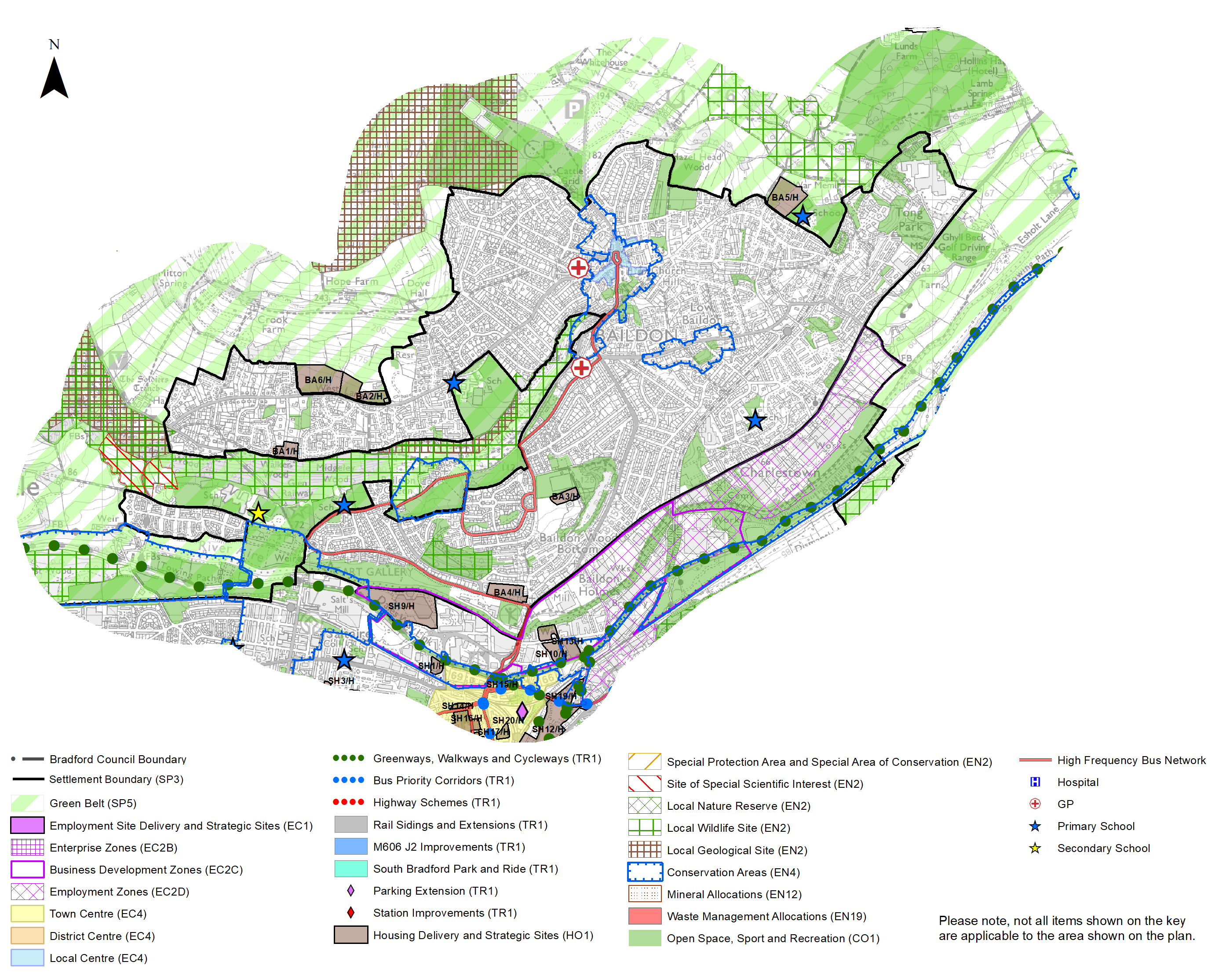
5.8.23 Baildon is reasonably constrained for allocations within the established settlement boundary and the local plan proposes to allocate six greenfield sites, including three Green Belt sites to meet the housing requirement for this area. In delivering the target for new homes in Baildon it has been necessary to make some changes to the adopted green belt. Policy SP5 sets out The Councils approach and justification for green belt releases to accommodate new development and lists the sites proposed for allocation which current lie within or partly within the green belt."
5.8.24 The new local plan preferred site allocations for residential and mixed allocations to meet Baildons housing requirement are set out in Table A and identified on the Policies Map and the Site Proformas below together with the local strategies map for each plan area. Development of site allocations should be in accordance with specified development guidelines and approximate site provision figures and all other relevant policies of this Local Plan.
Planning for Places and Communities
Green Belt, Natural Landscape and Historic Character
5.8.25 Baildon is surrounded by Green Belt, particularly to the north, east and west/south west. These areas fall within the Airedale, Esholt and Rombalds Ridge Landscape Character Areas. The prevailing landscape character is a mixture of types including enclosed pasture (to the east), gritstone moorland (to the north and south west), industrial corridor (to the south), mixed upland pasture (to the north/north west and east), wooded incline (to south west) and wooded valley (to the east and west). These are assessed as having varying strengths of character and historic continuity, and degrees of visibility and enclosure. The Landscape Character Assessment notes that some of these areas are moderately sensitive or sensitive to change. The gritstone moorland is classed as being very sensitive.
5.8.26 There are two designated Conservation Areas in Baildon, namely Baildon and Baildon Green. The section of the Leeds & Liverpool Canal Conservation is partially within and adjoining the built up area at its south west corner. The Conservation Area boundaries are shown on the Policies Map. Roberts Park (on the south western edge of Baildon and northern edge of Saltaire) is considered to be a nationally important site which has been included in the Register of Parks and Gardens of Special Historic Interest in England. The park is also identified as an archaeologically important site. There are a total of 44 Listed Buildings within the town, the majority of which (43) are Grade II Listed. There is one which is Grade II* Listed (Baildon). Five Scheduled Monuments are found close the western and north western edges of the built up area on Baildon Moor. The majority of these features are cup marked rocks. The Moor has been identified as an area of archaeological importance.
5.8.27 Baildon is within close proximity to the Saltaire World Heritage Site and as a result land to the north west covering much of Baildon Moor and the west of Baildon lies within the 500m Buffer Zone of the World Heritage Site. This zone will have implications for development as it may affect views into and out of the World Heritage Site should be protected.
Green Infrastructure (GI), Ecology, Open Space and Flood Risk
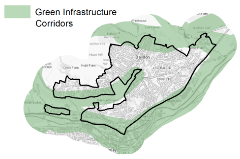
5.8.28 The town has a range of corridors and spaces that contribute towards its Green and Blue Infrastructure network. Key corridors include the valley of the River Aire (a regionally important GI corridor), Shipley Glen and the Gill Beck valley. Baildon Moor and Baildon Bank are also highly important components of this network. These corridors are detailed below in Figure 6.
Figure 6: Green Infrastructure Corridors
5.8.29 Baildon Moor and the countryside to the north, east and west of the settlement contain a number of biodiversity designations such as Local Wildlife Sites (LWS) – Baildon Bank; Baildon Moor; Fairbank Wood; Shipley Glen; Tong Park with Hawksworth Spring Wood; and Shipley Glen - and Local Geological Sites (LGS) – Baildon Bank & Baildon Green Quarries; Baildon Moor; and Shipley Glen. The Trench Meadows Site of Special Scientific Interest (SSSI) is adjacent to the south western edge of the built up area. There are also several areas of ancient woodland - Fairbank Wood and Walker/Midgeley Woods – within and adjacent to the settlement. The vast majority of Baildon falls within 7km of the South Pennine Moors (Phase 2) SPA and SAC (and SSSI).
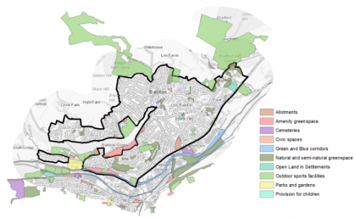
5.8.30 Baildon has a wide range of identified open spaces – totalling 74 sites with a land take of circa 199ha. Key sites within the town include Baildon Cricket Ground, Baildon Rugby Club, Baildon Golf Course, Hollins Hall Golf Course, Fairbank and The Dell Recreation Ground and Playing Fields. There are good levels of provision of certain typologies in this area, however there are deficiencies in provision in the northern part of the settlement (north of West Lane). There are high levels of deficiency in three typologies, where there is a need for increased provision – parks, cemeteries and allotments. In terms of cemetery provision, this type of space is often provided at a sub-area level and therefore provision of this type of space is not a mandatory requirement in every settlement. Any additional provision of such space may help to provide a more sustainable option for the residents of Baildon. Figure 7 below shows the location and type of open space in Baildon.
Figure 7: Baildon - Open Space Overview
5.8.31 Fluvial flood risk is generally associated with the River Aire to the south of Baildon. There are however identified areas of surface water flood risk across the town associated with principal transport routes.
Community Infrastructure – Education, Health and Utilities
5.8.32 In addition to the retail provision, described above, the town has a good range of community facilities and services to meet the day to day needs of the local population. This includes the town's library and range of spaces for local groups and functions. There is also a post office (located on Station Road), five public houses, a social club and eight Places of Worship.
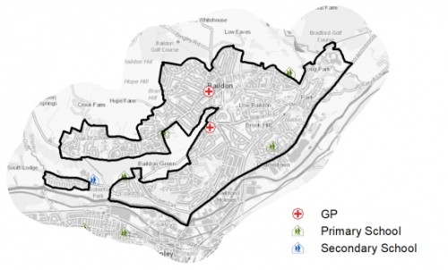
5.8.33 Baildon is served by 4 primary schools – Sandal Primary School, Baildon Church of England School, Hoyle Court Primary School and Glenaire Primary School - with the capacity to accommodate 1,417 pupils. Most schools are under capacity, with only one being over capacity. The nearest secondary school is Titus Salt School, located adjacent to Roberts Park in Saltaire. It has the capacity to accommodate 1,520 pupils. The school also includes sixth form provision. Pupils attainment levels at Key Stages 1,2 and 4 (GCSE) are generally above national average.
5.8.34 Shipley College is located in Saltaire, immediately to the south, and offers a range of full-time courses for school leavers, traineeships, apprenticeships and supported internships as well as part-time courses for adults looking to gain skills for professional and/or personal development.
5.8.35 Baildon has a two NHS registered healthcare facilities within the town. There are three GP surgeries/health centres covering Baildon and the surrounding area. Secondary (acute) healthcare is provided at Airedale General Hospital in Steeton and Bradford Royal Infirmary in the city. Average life expectancy for Baildon residents is 78 for men and 84 for women, which is similar to the West Yorkshire and England averages. Healthy life expectancy is 66 for men and 68 for women. Figure 8 below shows the location of local schools and medical facilities.
Figure 8: Schools & Medical Facilities in Baildon
5.8.36 When planning for the long-term development of Baildon, it is vital that new development is supported by the appropriate infrastructure. The capacity, quality and accessibility of services and facilities are all key components in ensuring people can enjoy living, working and visiting the area. The Council will continue work with key infrastructure providers and others including the Local Education Authority, Clinical Commissioning Group and utilities providers to determine the impacts of future growth and development on local infrastructure capacity and provision. Further infrastructure details will be published through the Local Infrastructure Plan and as part of the Regulation 19 stage of the local plan.
|
Local Area Strategy and Plan - Baildon |
|
The key elements of the local area strategy for Baildon include:
|
(34) Consultation Question 98
Baildon Local Area Strategy
The Local Plan sets out a local area strategy for Baildon.
Q. Please provide any comments you may have on the area strategy?
If you have an alternative to the approach undertaken, please provide further details and evidence in support.
Preferred Site Allocations and Site Pro Formas
5.8.37 The preferred housing site allocations are detailed below in Tables A. This table is subsequently followed by site pro formas for each preferred site allocation proving a summary of key site information and characteristics.
Table A: Housing & Mixed Use - Preferred Allocations
|
Site Ref |
Site Name |
Dwellings / Other Uses |
|
BA1/H |
Stubbings Road |
5 |
|
BA2/H |
West Lane (1) |
46 |
|
BA3/H |
Cliffe Lane West |
20 |
|
BA4/H |
Green Lane |
30 |
|
BA5/H |
Meadowside Road, West of Baildon CE Primary School |
40 |
|
BA6/H |
West Lane (2) |
76 |
|
Total |
217 |
(10) Consultation Question 99
Baildon Site Allocations and Site Pro Formas
The Local Plan sets out a series of preferred site allocations. If you wish to make representations on any of the sites proposed, please provide site reference and feedback under this question.
If you wish to propose an additional or alternative site(s) to the preferred allocations listed, please also provide a plan with a red line and any further details in support.
[1] Universal Service Obligation (USO) - download speeds at or above 10Mbit/s and upload speeds at or above 1Mbit/s including non-matched records and zero predicted speeds
(32) BA1/H - Stubbings Road
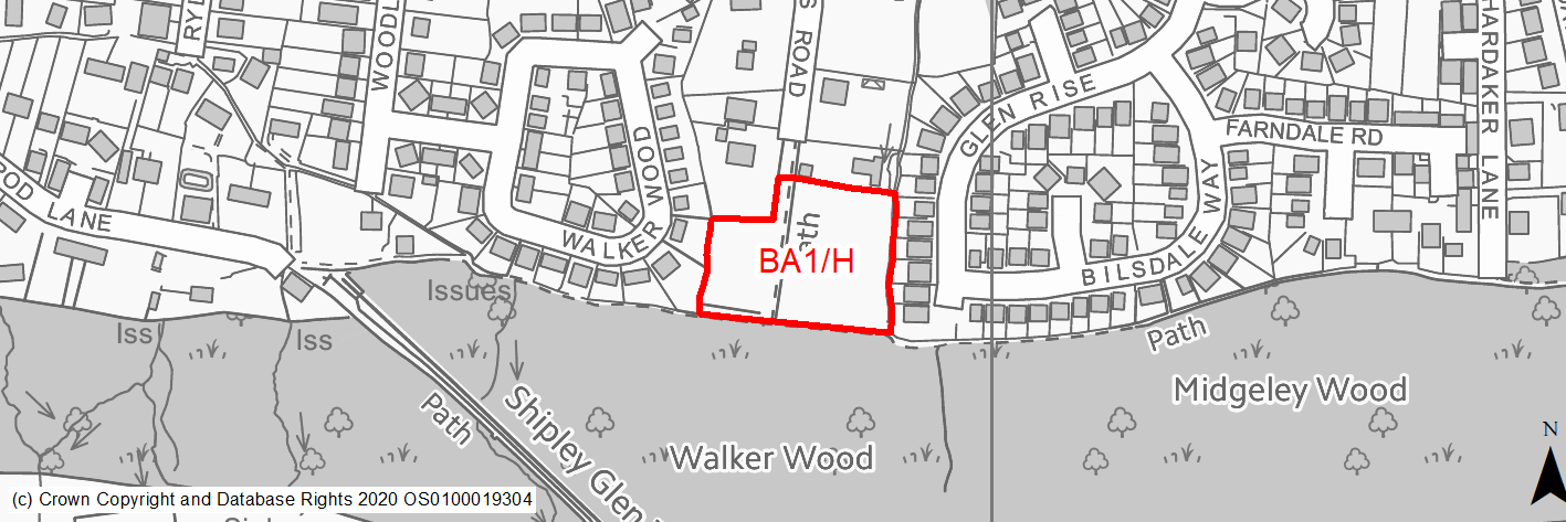
Site location
Local Service Centre - Baildon
Ward
Baildon
Site description
The site consists of an area of unused land situated off a private road.
Proposed Allocation
Housing
SHLAA referencce
BA/002
Indicative no. dwellings
5
Site area (Gross) (ha)
0.78
Ownership
Private
Delivery timescales
Deliverable (0 to 5 years)
Type (PDL/Greenfield)
Greenfield
Green Belt
No
Flood Zone
Flood Zone 1
Potential site access
Existing access is available from Stubbins Lane and narrow pathway. It should be noted that the pending planning application identifies an access from Walker Wood using an existing dwelling that would be demolished.
Public Transport Accessibility
Bus: The nearest bus stops are located around 215m to the north of the site on West Lane. These offer one service per hour (eastbound) towards Bradford city centre and one service per hour (westbound) towards Baildon (Lucy Hall Drive) (Service 656). Other stops are located around 350m (circa 10 mins walk) to the south east on Thompson Lane. These offer2 services per hour in each direction to Baildon (Towngate), Shipley and Bradford City Centre (Service 626).
Rail: Saltaire railway station is located around 700m (in a straight line)/1.3km (via quickest walking route) (circa 18 minutes) to the south of the site. This offers 8 services per hour towards Skipton and Keighley (4 per hour), Bradford Forster Square (2 per hour) and Leeds (2 per hour).
Sustainability Appraisal
This site could deliver a major positive effect for residents on the education SA Objective, as a result of being within the target distance for both primary and secondary education facilities. No major adverse effects are anticipated.
Minor adverse effects were predicted for a range of natural environment themed SA Objectives, primarily as a result of new development taking place on a 100% greenfield site, its proximity to a Local Wildlife Site (LWS) which is also an area of Ancient Woodland and Priority Habitat, and the presence of a TPO protected woodland and a TPO protected tree onsite.
Minor positive effects were predicted for most socio-economic themed SA Objectives due to the benefits of new residential development for the local economy as well as the location of the site in relation to transport links and employment areas.
Habitats Regulations Assessment
This site falls within 7km of the South Pennine Moors SPA/SAC. An HRA must be undertaken to ensure there are no significant effects on these protected sites. Developments within these zones must comply with Policy SP11; a SPD is being produced to provide further guidance.
Green Belt
N/A – Site not within the Green Belt.
Constraints and Opportunities
• This is a gently sloping, greenfield site within the settlement boundary for Baildon. It consists of a mixture of woodland and grassland and is within an established residential area.
• It is located within the Saltaire World Heritage Site buffer zone and is adjacent to an area of ancient woodland and a Local Wildlife Site as well as areas of TPO woodland.
• Several public rights of way run through and adjacent to the site, whilst there is a watercourse on the eastern boundary.
• It is within the 7km buffer of the SPA/SAC.
Development considerations
• Sensitive design is required to mitigiate/reduce impacts on the setting of the Saltaire World Heritage Site as well as views to/from it.
• Ecological survey is required to assess the impact on adjacent habitats (Ancient Woodland) and nature conservation designations.
• Access is available via Stubbings Lane, however this should be investigated further.
• Public Rights of Way should be included within the layout of any development.
Conclusion/Summary
This is a sustainable site located within the settlement boundary for Baildon close to local services and facilities including primary and secondary schools as well as public transport services. Sensitive design and layout will be required in this location to mitigate impacts on the surrounding heritage and natural environment designations. It will deliver an estimated 5 dwellings.
(153) BA2/H - West Lane
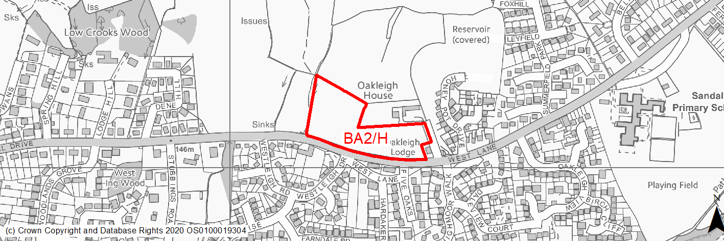
Site location
Local Service Centre - Baildon
Ward
Baildon
Site description
The site consists of a large area of agricultural land divided into five sections by several dry stone walls and belts of trees (varying sizes). It is currently used for animal grazing.
Proposed Allocation
Housing
SHLAA referencce
BA/005a
Indicative no. dwellings
46
Site area (Gross) (ha)
1.77
Ownership
Private
Delivery timescales
Developable (6 to 15 years)
Type (PDL/Greenfield)
Greenfield
Green Belt
Yes
Flood Zone
Flood Zone 1
Potential site access
Existing field access via site BA/023 from West Lane. Other possible access point may be via Honey Pot Lane, close the south eastern boundary. No visibility splay issues.
Public Transport Accessibility
Bus: The nearest bus stops are located immediately adjacent to the southern boundary of the site on West Lane. These offer one service per hour (eastbound) towards Bradford city centre and one service per hour (westbound) towards Baildon (Lucy Hall Drive).
Rail: Saltaire railway station is located around 1.1km (in a straight line)/1.8km (via quickest walking route) (circa 24 minutes) to the south of the site. This offers 8 services per hour towards Skipton and Keighley (4 per hour), Bradford Forster Square (2 per hour) and Leeds (2 per hour).
Sustainability Appraisal
This site could deliver a major positive effect for residents on the education SA Objective, as a result of being within the target distance for both primary and secondary education facilities.
Minor adverse effects are predicted for the sites impact on the water resources SA Objective due to the presence of a small stream adjacent to the site’s perimeter which could be impacted by the construction and occupation of this site.
Minor adverse effects were predicted for a range of natural environment themed SA Objectives, primarily as a result of new development taking place on a 100% greenfield site and Green Belt land, and an area of TPO woodland adjacent to the site.
Minor positive effects were predicted for most socio-economic themed SA Objectives due to the benefits of new residential development for the local economy as well as the location of the site in relation to transport links and employment areas.
Habitats Regulations Assessment
This site falls within 7km of the South Pennine Moors SPA/SAC. A HRA must be undertaken to ensure there are no significant effects on these protected sites. Developments within these zones must comply with Policy SP11; a SPD is being produced to provide further guidance.
Green Belt
Based on planning judgement the site has a moderate potential impact on the Green Belt.
• The site is located in a major Green Belt parcel.
• The site makes a moderate contribution to the purposes of including land in the Green Belt.
• The site has a moderate potential for sprawl and would have a major impact on openness.
• There is limited opportunity to create a stronger Green Belt boundary.
Constraints and Opportunities
• This is a gently sloped, greenfield site within the Green Belt adjoining the settlement boundary for Baildon.
• The site specific Green Belt assessment indicates that it has a moderate potential impact. It consists of agricultural fields.
• It is within the Saltaire World Heritage Site buffer zone.
• There is also potential for signifcant impacts on the landscape, whilst there are also anumber of watercourses and wet areas within the site.
• It is within the 7km buffer of the SPA/SAC.
Development considerations
• Provision of compensatory improvements to the surrounding Green Belt which may include enhancement of the existing rights of way within the vicinity of the site.
• An ecological assessment will be required.
• A Flood Risk Assessment will be required (site is over 1ha).
• A landscape impact assessment will be required to assess the impact of development on the wider landscape.
• A sensitive design and layout will be required, including consideration of topography, building heights and appropriate screening to mitigate any impact on the landscape.
• Heritage impact assessment will be required to determine impact of setting of the Saltaire World Heritage Site and the views to/from it.
• A landscape buffer should be provided along the northern boundary of the site to reduce potential heritage/landscape impacts.
• Vehicular and pedestrian access is available from West Lane, although consideration should be given to impacts on the wider highway network.
Conclusion/Summary
This is a sustainable site located adjacent to the settlement boundary. It site would deliver an estimated 46 dwellings but will need a sensitive design and layout to mitigate the landscape and heritage impacts.
(12) BA3/H - Cliffe Lane West
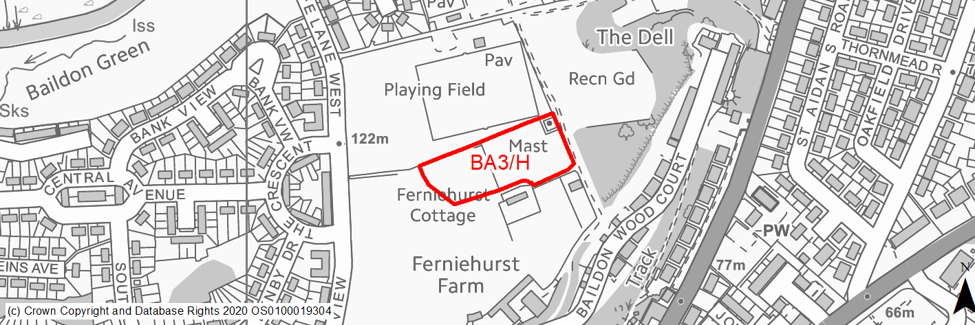
Site location
Local Service Centre - Baildon
Ward
Baildon
Site description
The site consists of former playground/playing fields for a school that has been demolished.
Proposed Allocation
Housing
SHLAA referencce
BA/008B
Indicative no. dwellings
20
Site area (Gross) (ha)
0.63
Ownership
Council
Delivery timescales
Developable (6 - 10 years)
Type (PDL/Greenfield)
Greenfield
Green Belt
No
Flood Zone
Flood Zone 1
Potential site access
Existing access is via adjacent bridleway, which would not be suitable. It should that there is potential access from the adjacent housing development (Richard Whiteley Drive).
Public Transport Accessibility
Bus: The nearest bus stops are located around 190m and 240m respectively to the south of the site on Baildon Road. The former offers 1 service per hour towards Baildon, whilst the latter offers 1 service per hour to Bradford city centre. Other stops are available around 140m to the west of the site on Denby Drive and The Crescent respectively. The former offers 3 services per hour towards Bradford city centre, whilst the latter offers 3 service per hour towards Baildon.
Rail: Shipley railway station is located around 1.1km (in a straight line)/1.2km (via the quickest walking route) (circa 16 minutes) to the south of the site. This offers 16 (occasionally 18) services per hour towards Bradford Forster Square (6 per hour); Leeds (4 [occasionally 5] per hour; Ilkley (2 per hour); Skipton (4 per hour); and Carlisle & Lancaster (roughly every two hours).
Sustainability Appraisal
This site could deliver a major positive effect for residents on the health SA Objective, as a result of being within the target distance for all necessary health facilities.
Minor adverse effects were predicted for a range of natural environment themed SA Objectives, primarily as a result of new development taking place on a predominantly greenfield site.
Minor positive effects were predicted for most socio-economic themed SA Objectives due to the benefits of new residential development for the local economy as well as the location of the site in relation to transport links, education facilities and employment areas.
The site falls within the buffer zone of the Saltaire WHS. The WHS is just over 1km south-west of the site and so effects on the WHS may be unlikely. However, this may need to be a consideration of any planning application at the site.
Habitats Regulations Assessment
This site falls within 7km of the South Pennine Moors SPA/SAC. A HRA must be undertaken to ensure there are no significant effects on these protected sites. Developments within these zones must comply with Policy SP11; a SPD is being produced to provide further guidance.
Green Belt
N/A – Site not within the Green Belt.
Constraints and Opportunities
• This is a gently sloping, greenfield site within the built up area of Baildon and is currently in use for agriculture.
• It is designated as a playing field.
• It is within the vicinity of a Listed Building (Grade II) and within the Saltaire World Heritage Site buffer zone.
• In addition is enclosed by priority habitats, and is within the 7km buffer of the SPA/SAC.
Development considerations
• Sensitive design and layout will be required to ensure the protection and enhance of the Listed Building and its setting.
• Heritage Impact Assessment required to assess and mitigate impacts on Listed Builded and World Heritage Site.
• Ecological survey required to assessment impact on adjacent priority habitats.
• Potential access from Richard Whiteley Drive development.
Conclusion/Summary
This is a sustainable site within the built up area of Baildon, close to local services and facilities include primary school, playing fields/recreation ground and frequent public transport services. It would deliver an estimated 20 dwellings but will need sensitive design and layout to mitigate heritage impacts.
(33) BA4/H - Green Lane
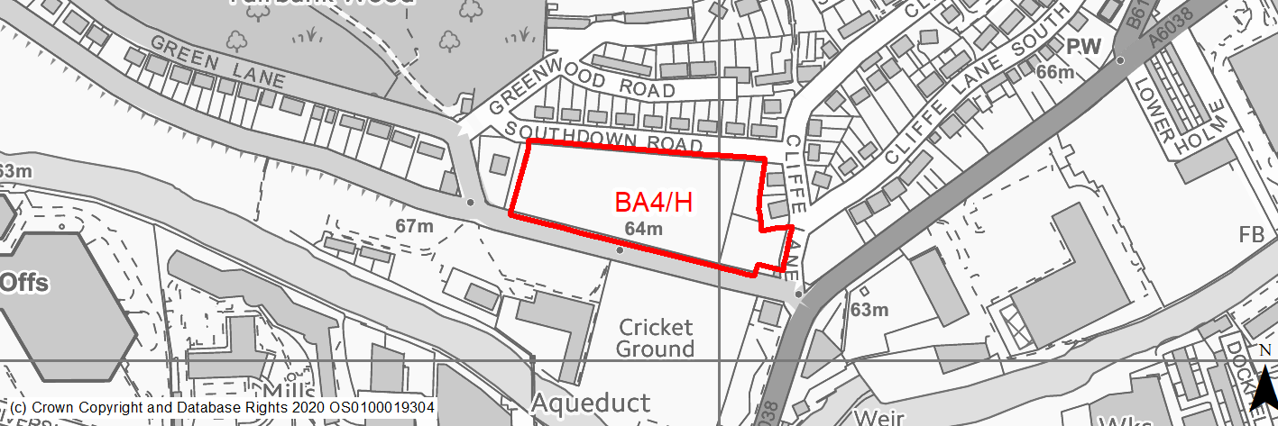
Site location
Local Service Centre - Baildon
Ward
Baildon
Site description
The site consists of two sections. The first is an open grassed area surrounded by mature trees with some woodland. The second section consists of the cleared site of a former college building.
Proposed Allocation
Housing
SHLAA referencce
BA/011
Indicative no. dwellings
30
Site area (Gross) (ha)
1.23
Ownership
Council
Delivery timescales
Developable (6 - 10 years)
Type (PDL/Greenfield)
Greenfield
Green Belt
No
Flood Zone
Flood Zone 1 (85%), Flood Zone 2 (11%), Flood Zone 3a (4%).
Potential site access
Existing access points available from Green Lane.
Public Transport Accessibility
Bus: The nearest bus stops are located immediately adjacent to the southern boundary of the site on Green Lane. These offer four services per hour (eastbound) towards Bradford city centre (3 per hour) and Shipley (1 per hour) and four services per hour (westbound) towards Baildon. Other bus stops are available around 80m and 125m to the south on Otley Road. The former offers 5 (sometimes 6) service per hour towards Baildon (4, sometimes 5 per hour) and Leeds Bradford Airport via Guiseley (1 per hour). The latter offers 6 (sometimes 4) services per hour towards Bradford City Centre and Shipley.
Rail: Shipley railway station is located 530m (in a straight line)/750m (via quickest walking route) (circa 11 minutes) to the south of the site. This offers 16 (occasionally 18) services per hour towards Bradford Forster Square (6 per hour); Leeds (4 [occasionally 5] per hour; Ilkley (2 per hour); Skipton (4 per hour); and Carlisle & Lancaster (roughly every two hours).
Sustainability Appraisal
This site could deliver a major positive effect for residents on the health and transport SA Objectives, as a result of being within the target distance for all necessary health facilities as well as being within the target distance of bus stops and a railway station (in Shipley).
Minor adverse effects were predicted for most natural environment themed SA Objectives, primarily as a result of new development on a greenfield site. There site is in proximity to a CAZ and so could make achieving air quality improvements there more difficult.
The site falls within the buffer zone of the Saltaire WHS. The WHS is just over 500m south-west of the site and effects on the WHS are largely uncertain but a negative effect cannot be ruled out at this stage. This may therefore need to be a consideration of any planning application at the site.
Habitats Regulations Assessment
This site falls within 7km of the South Pennine Moors SPA/SAC. A HRA must be undertaken to ensure there are no significant effects on these protected sites. Developments within these zones must comply with Policy SP11; a SPD is being produced to provide further guidance.
Green Belt
N/A – Site not within the Green Belt.
Constraints and Opportunities
• This is a predominatley level, greenfield site with the built up area of Baildon. It includes a number of mature trees around its perimeter and used for grazining.
• In addtion, it is within the Saltaire World Heritage Site buffer and Green Infrastructure corridor.
• Areas of higher flood risk are found within part of the site.
• Close to high frequency bus routes and within walking distance of a railway station (Shipley).
• Within the 7km buffer of the SPA/SAC.
Development considerations
• Existing mature trees should be retained and preserve with any development.
• Design and layout should be congisant of existing sensitive receptors (nearby residential properties and footpaths).
• Design should also reflect its location on a key approach to the Saltaire World Heritage site.
• Flood risk assessment will be required.
• Ecological survey is require.
• Access can be obtained from Green Lane, however appropriate consideration should be given to the impacts on the existing Otley Road/Green Lane junction.
Conclusion/Summary
This is a sustainable site within the built up area of Baildon, close to local services and facilities include primary school, playing fields/recreation ground and frequent public transport services. It would deliver an estimated 30 dwellings but will need sensitive design and layout to mitigate heritage impacts.
(146) BA5/H - Meadowside Road/West of Baildon Cof E Primary School
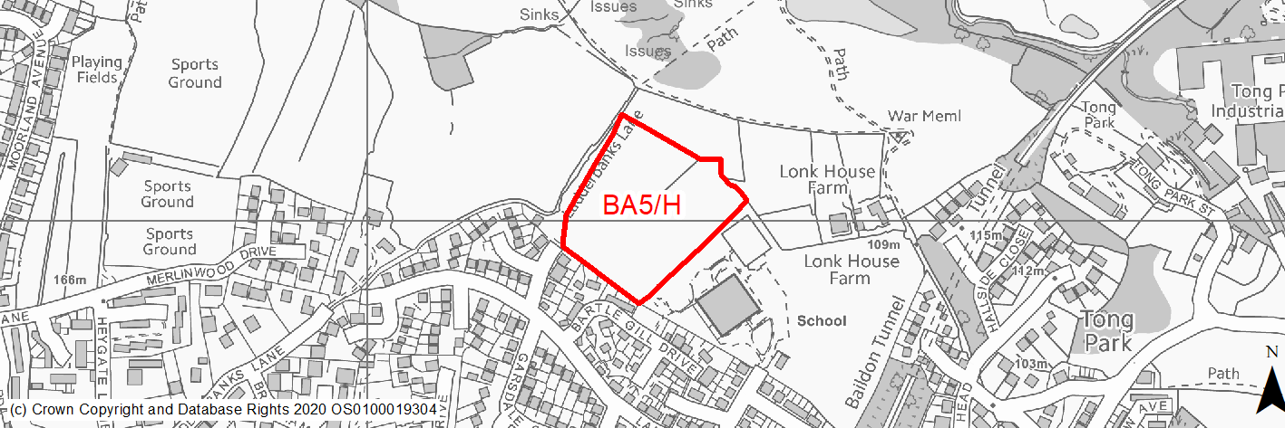
Site location
Local Service Centre - Baildon
Ward
Baildon
Site description
The site consists of open land which is level in parts but generally slopes away from the adjacent residential development. It includes scattered trees and shrubs with its boundary as well as trees around the edges. It is currently used for horse grazing.
Proposed Allocation
Housing
SHLAA referencce
BA/022
Indicative no. dwellings
40
Site area (Gross) (ha)
2.16
Ownership
Private
Delivery timescales
Developable (6 - 10 years)
Type (PDL/Greenfield)
Greenfield
Green Belt
Yes
Flood Zone
Flood Zone 1
Potential site access
Potential access available from Meadowside Road, however may require some additional third party land due to configuration of the site boundary.
Public Transport Accessibility
Bus: The nearest bus stop is located around 180m to the south of the site on Garsdale Crescent. This offers an irregular service to Shipley and Esholt.
Rail: Baildon railway station is located round 525m (in a straight line)/800m (via quickest walking route) (circa 10 minutes) to the south of the site. This offers 4 services per hour towards Bradford Forster Square (2 per hour) and Ilkley (2 per hour).
Sustainability Appraisal
Site is located in a high accessible area of Baildon being in proximity to a large number of local services, facilities, and transport links, including Baildon Railway Station.
Minor adverse effects were predicted for a range of natural environment themed SA Objectives, primarily as a result of new development taking place on a 100% greenfield site, an area of TPO woodland adjacent to the site and 30m from a LWS.
Minor positive effects were predicted for most socio-economic themed SA Objectives due to the benefits of new residential development for the local economy as well as the location of the site in relation to transport links, educational facilities, and employment areas.
Habitats Regulations Assessment
This site falls within 7km of the South Pennine Moors SPA/SAC. A HRA must be undertaken to ensure there are no significant effects on these protected sites. Developments within these zones must comply with Policy SP11; a SPD is being produced to provide further guidance.
Green Belt
Based on planning judgement the site has a major potential impact on the Green Belt.
• The site is located in moderate Green Belt parcel.
• The site makes a moderate contribution to the purposes of including land in the Green Belt.
• The site has a high potential for sprawl and would have a major impact on openness.
• There is no opportunity to create a stronger Green Belt boundary.
Constraints and Opportunities
• This is sloping, greenfield site within the Green Belt adjoining the settlement boundary for Baildon. The site specific Green Belt assessment indicates that it has a major potential impact. It is located adjacent to a primary school and residential development, whilst a Public Right of Way runs along the boundary.
• There is also potential for landscape impacts as well as on adjacent sensitive receptors (footpaths).
• At TPO tree and an area of TPO woodland are present.
• It is within the 7km buffer of the SPA/SAC.
Development considerations
• Provision of compensatory improvements to the surrounding Green Belt which may include enhancement of the existing rights of way within the vicinity of the site.
• An ecological assessment will be required.
• A landscape impact assessment will be required to assess the impact of development on the wider landscape.
• A sensitive design and layout will be required, including consideration of topography, building heights and appropriate screening to mitigate any impact on the landscape.
• Access is available from Meadowside Road.
• Opportunities to improve public transport accessibility should be investigated.
Conclusion/Summary
This is a sustainable site located adjacent to the settlement boundary with access to local facilities, most notably a primary school. The site would deliver an estimated 40 dwellings but will need a sensitive design and layout to mitigate the landscape impacts, as well as opportunities for improved public transport access.
(150) BA6/H - West Lane
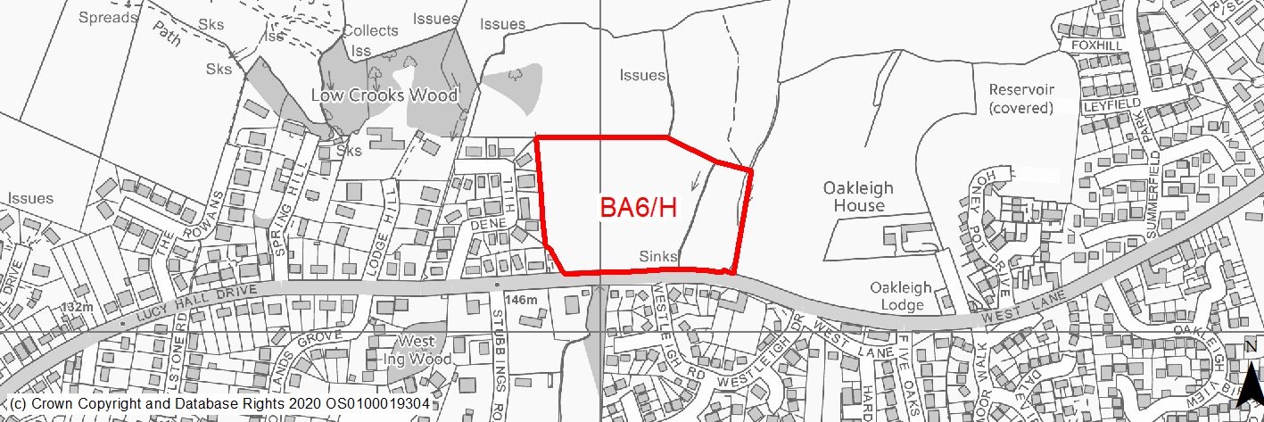
Site location
Local Service Centre - Baildon
Ward
Baildon
Site description
The site consists of four agricultural fields that are used for animal grazing. It is level towards the southern edge (adjacent to West Lane) but begins to slope steeply form the centre towards the northern edge. There are a number of trees within the site, along field boundaries as well as along the site boundary. A stream is present adjacent to the eastern edge.
Proposed Allocation
Housing
SHLAA referencce
BA/023a
Indicative no. dwellings
76
Site area (Gross) (ha)
2.89
Ownership
Private
Delivery timescales
Developable (10 - 15 years)
Type (PDL/Greenfield)
Greenfield
Green Belt
Yes
Flood Zone
Flood Zone 1
Potential site access
Existing field access from West Lane.
Public Transport Accessibility
Bus: The nearest bus stops are located immediately adjacent to the southern boundary of the site on West Lane. These offer one service per hour (eastbound) towards Bradford city centre and one service per hour (westbound) towards Baildon (Lucy Hall Drive).
Rail: Saltaire railway station is located around 1.1km (in a straight line)/1.8km (via quickest walking route) (circa 24 minutes) to the south of the site. This offers 8 services per hour towards Skipton and Keighley (4 per hour), Bradford Forster Square (2 per hour) and Leeds (2 per hour).
Sustainability Appraisal
This site could deliver a major positive effect for residents on the education SA Objective, as a result of being within the target distance for both primary and secondary education facilities.
No major adverse effects are predicted. Minor adverse effects were predicted for a range of natural environment themed SA Objectives, primarily as a result of new development taking place on a 100% greenfield site and Green Belt land, and an area of TPO woodland adjacent to the site.
Minor positive effects were predicted for most socio-economic themed SA Objectives due to the benefits of new residential development for the local economy as well as the location of the site in relation to transport links, educational facilities and employment areas.
Habitats Regulations Assessment
This site falls within 7km of the South Pennine Moors SPA/SAC. A HRA must be undertaken to ensure there are no significant effects on these protected sites. Developments within these zones must comply with Policy SP11; a SPD is being produced to provide further guidance.
Green Belt
Based on planning judgement the site has a moderate potential impact on the Green Belt.
• The site is located in a major Green Belt parcel.
• The site makes a moderate contribution to the purposes of including land in the Green Belt.
• The site has a moderate potential for sprawl and would have a major impact on openness.
• There is limited opportunity to create a stronger Green Belt boundary.
Constraints and Opportunities
• This is a sloped, greenfield site within the Green Belt adjoining the settlement boundary for Baildon. The site specific Green Belt assessment indicates that it has a moderate potential impact. It consists of agricultural fields.
• It is within the Saltaire World Heritage Site buffer zone.
• There is also potential for signifcant impacts on the landscape, whilst there are also a number of watercourses and wet areas within the site.
• It is within the 7km buffer of the SPA/SAC.
Development considerations
• Provision of compensatory improvements to the surrounding Green Belt which may include enhancement of the existing rights of way within the vicinity of the site.
• An ecological assessment will be required.
• A Flood Risk Assessment will be required (site is over 1ha).
• A landscape impact assessment will be required to assess the impact of development on the wider landscape.
• A sensitive design and layout will be required, including consideration of topography, building heights and appropriate screening to mitigate any impact on the landscape.
• Heritage impact assessment will be required to determine impact of setting of the Saltaire World Heritage Site and the views to/from it.
• Landscape buffer will be required at the northern boundary to reduce potential visual, landscape and heritage impacts.
• Vehicular and pedestrian access is available from West Lane, although consideration should be given to impacts on the wider highway network.
Conclusion/Summary
This is a sustainable site located adjacent to the settlement boundary. It site would deliver an estimated 76 dwellings but will need a sensitive design and layout to mitigate the landscape and heritage impacts.